Mapping and Estimating Blue Carbon in Mangrove Forests Using Drone and Field-Based Tree Height Data: A Cost-Effective Tool for Conservation and Management
Abstract
1. Introduction
1.1. Drone-Based Estimation of Biomass and Carbon in Coastal Ecosystems
1.2. Structural Trait Extraction and Limitations
1.3. Species Classification and Health Assessment
1.4. Individual Tree-Based Approaches
2. Materials and Methods
2.1. Study Site
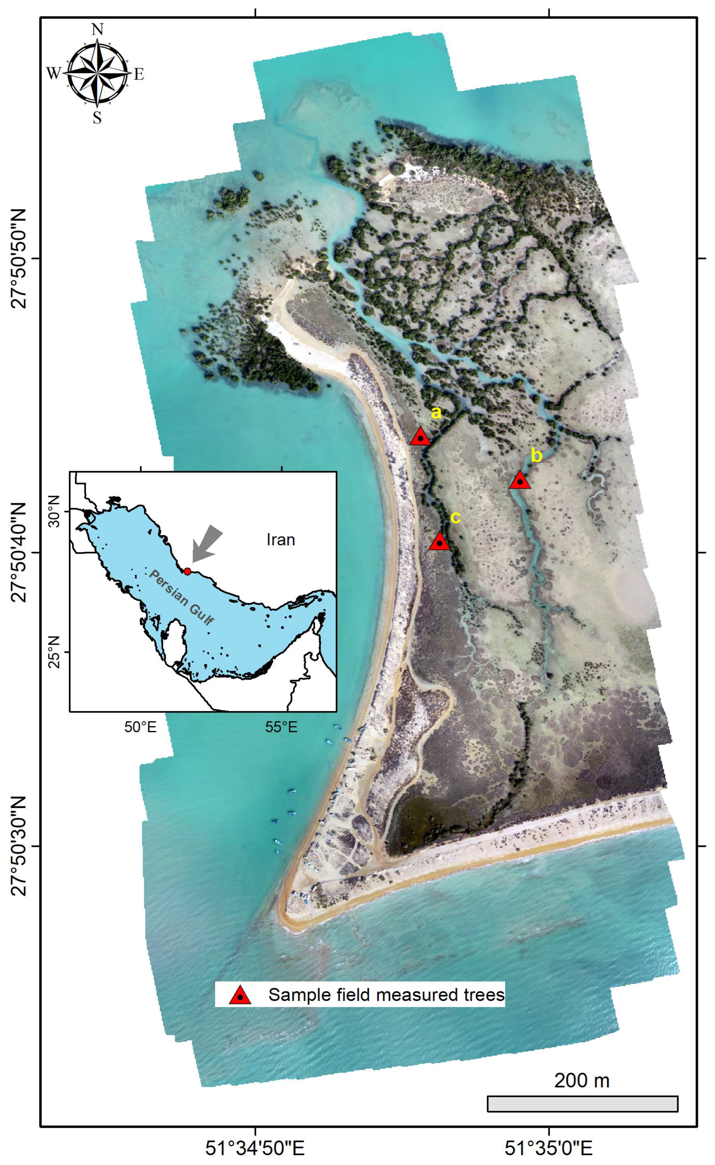
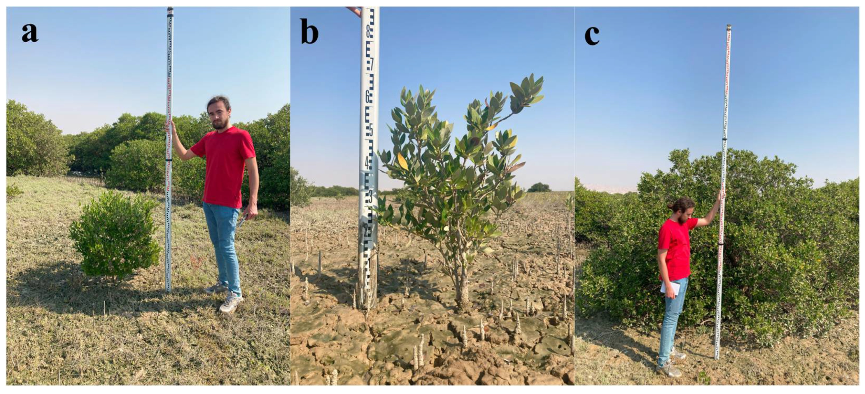
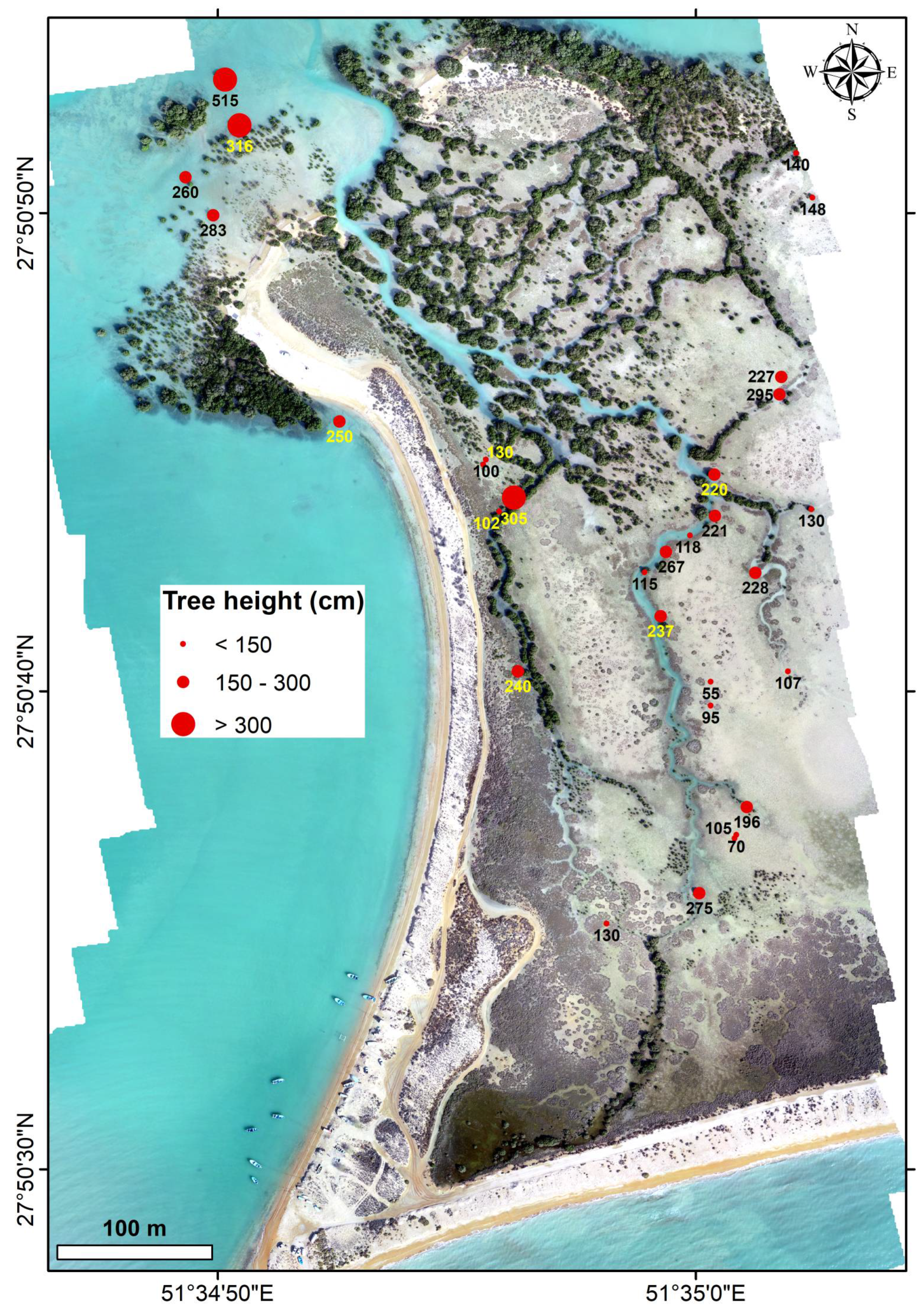
2.2. Field Data Collection
2.3. Drone-Based Data Acquisition
2.4. Image Processing
2.5. Biomass and Blue Carbon Estimation
2.6. Statistical Analysis
- (i)
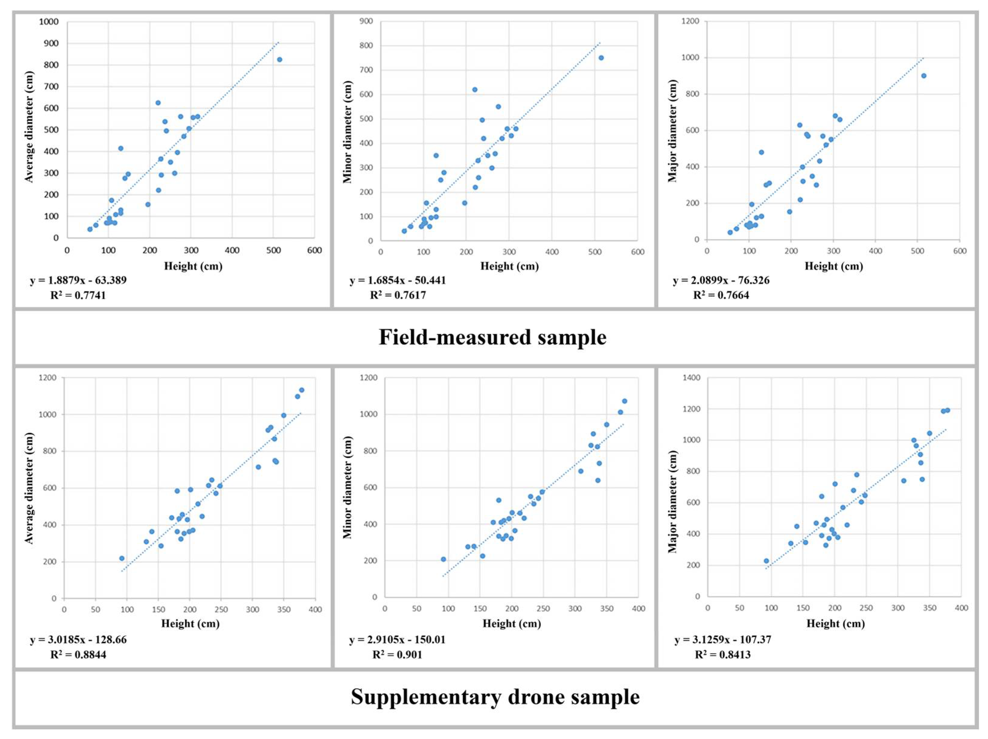
- Height vs. average crown diameter;
- (ii)
- Height vs. minor crown diameter;
- (iii)
- Height vs. major crown diameter.
- (i)
- Trees < 150 cm;
- (ii)
- Trees > 150 cm and < 300 cm;
- (iii)
- Trees > 300 cm.
3. Results
3.1. Drone-Derived Geospatial Data Products
3.2. Field Measurements Output

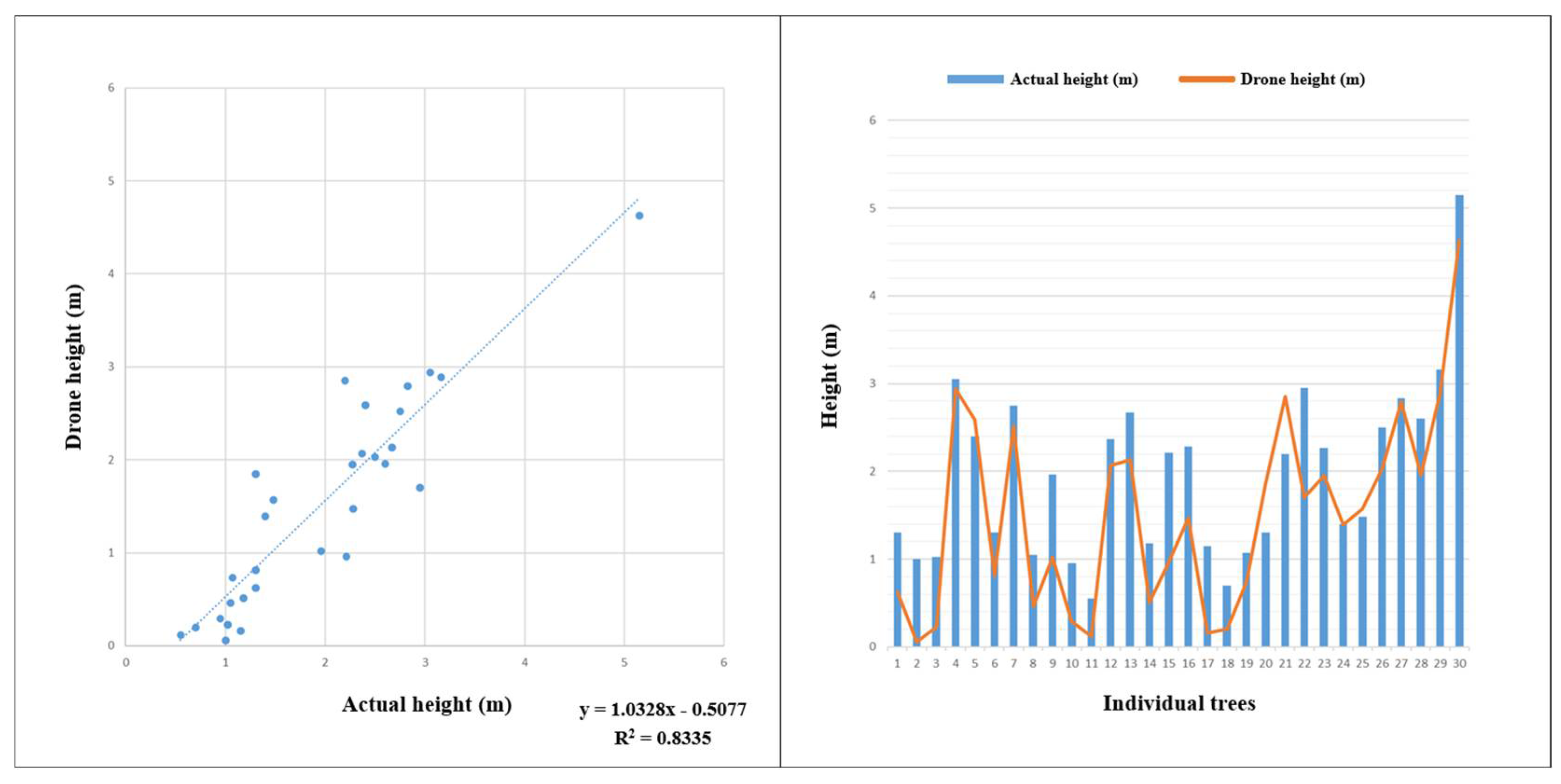
3.3. Field and Drone Data Comparison
3.4. Allometric Modeling Results
3.5. Tree Height Grouping and Carbon Distribution
3.6. Total Estimated Biomass and Blue Carbon
4. Discussion
4.1. Overview of Key Findings
4.2. Evaluation of Drone Accuracy and Sources of Error
4.3. Comparison with Previous Studies
4.4. Practical Implications for Conservation and Research
4.5. Limitations and Future Work
5. Conclusions
Author Contributions
Funding
Data Availability Statement
Acknowledgments
Conflicts of Interest
References
- Solórzano, J.V.; Peralta-Carreta, C.; Gallardo-Cruz, J.A. Mapping Tropical Forested Wetlands Biomass with LiDAR: A Machine Learning Comparison. Remote Sens. 2025, 17, 1076. [Google Scholar] [CrossRef]
- Alongi, D.M. Carbon cycling and storage in mangrove forests. Ann. Rev. Mar. Sci. 2014, 6, 195–219. [Google Scholar] [CrossRef] [PubMed]
- Duarte, C.M.; Middelburg, J.J.; Caraco, N. Major role of marine vegetation on the oceanic carbon cycle. Biogeosciences 2005, 2, 1–8. [Google Scholar] [CrossRef]
- Bergamaschi, B.A.; Krabbenhoft, D.P.; Aiken, G.R.; Patino, E.; Rumbold, D.G.; Orem, W.H. Tidally driven export of dissolved organic carbon, total mercury, and methylmercury from a mangrove-dominated estuary. Environ. Sci. Technol. 2012, 46, 1371–1378. [Google Scholar] [CrossRef] [PubMed]
- Kuenzer, C.; Bluemel, A.; Gebhardt, S.; Quoc, T.V.; Dech, S. Remote Sensing of Mangrove Ecosystems: A Review. Remote Sens. 2011, 3, 878–928. [Google Scholar] [CrossRef]
- Tran, T.V.; Reef, R.; Zhu, X. A review of spectral indices for mangrove remote sensing. Remote Sens. 2022, 14, 4868. [Google Scholar] [CrossRef]
- Lovelock, C.E.; McAllister, R.R.J. ‘Blue carbon’ projects for the collective good. Carbon Manag. 2013, 4, 477–479. [Google Scholar]
- Wylie, L.; Sutton-Grier, A.E.; Moore, A. Keys to successful blue carbon projects: Lessons learned from global case studies. Mar. Policy 2016, 65, 76–84. [Google Scholar] [CrossRef]
- Song, S.; Ding, Y.; Li, W.; Meng, Y.; Zhou, J.; Gou, R.; Zhang, C.; Ye, S.; Saintilan, N.; Krauss, K.W. Mangrove reforestation provides greater blue carbon benefit than afforestation for mitigating global climate change. Nat. Commun. 2023, 14, 756. [Google Scholar] [CrossRef] [PubMed]
- Jones, T.G.; Glass, L.; Gandhi, S.; Ravaoarinorotsihoarana, L.; Carro, A.; Benson, L.; Ratsimba, H.R.; Giri, C.; Randriamanatena, D.; Cripps, G. Madagascar’s mangroves: Quantifying nation-wide and ecosystem specific dynamics, and detailed contemporary mapping of distinct ecosystems. Remote Sens. 2016, 8, 106. [Google Scholar] [CrossRef]
- Kabiri, K.; Abedi, E. Rapid mangrove dieback in the northern Persian Gulf driven by anthropogenic activities and environmental stressors. Discov. Environ. 2025, 3, 22. [Google Scholar] [CrossRef]
- Guo, S.; Nie, H. Estimation of mariculture carbon sinks in China and its influencing factors. J. Mar. Sci. Eng. 2024, 12, 724. [Google Scholar] [CrossRef]
- Garofalo, S.P.; Giannico, V.; Lorente, B.; García, A.J.G.; Vivaldi, G.A.; Thameur, A.; Salcedo, F.P. Predicting carob tree physiological parameters under different irrigation systems using Random Forest and Planet satellite images. Front. Plant Sci. 2024, 15, 1302435. [Google Scholar] [CrossRef] [PubMed]
- Ma, Y.; Chen, S.; Ermon, S.; Lobell, D.B. Transfer learning in environmental remote sensing. Remote Sens. Environ. 2024, 301, 113924. [Google Scholar] [CrossRef]
- Navarro, A.; Young, M.; Allan, B.; Carnell, P.; Macreadie, P.; Ierodiaconou, D. The application of Unmanned Aerial Vehicles (UAVs) to estimate above-ground biomass of mangrove ecosystems. Remote Sens. Environ. 2020, 242, 111747. [Google Scholar] [CrossRef]
- Kabiri, K. Mapping coastal ecosystems and features using a low-cost standard drone: Case study, Nayband Bay, Persian gulf, Iran. J. Coast. Conserv. 2020, 24, 62. [Google Scholar] [CrossRef]
- Akinaga, T.; Saito, M.; Onodera, S.; Hyodo, F. UAV visual imagery-based evaluation of blue carbon as seagrass beds on a tidal flat scale. Remote Sens. Appl. Soc. Environ. 2025, 37, 101430. [Google Scholar] [CrossRef]
- Jones, A.R.; Raja Segaran, R.; Clarke, K.D.; Waycott, M.; Goh, W.S.H.; Gillanders, B.M. Estimating mangrove tree biomass and carbon content: A comparison of forest inventory techniques and drone imagery. Front. Mar. Sci. 2020, 6, 784. [Google Scholar] [CrossRef]
- Ou, J.; Tian, Y.; Zhang, Q.; Xie, X.; Zhang, Y.; Tao, J.; Lin, J. Coupling UAV hyperspectral and LiDAR data for mangrove classification using XGBoost in China’s Pinglu Canal Estuary. Forests 2023, 14, 1838. [Google Scholar] [CrossRef]
- Deng, L.; Chen, B.; Yan, M.; Fu, B.; Yang, Z.; Zhang, B.; Zhang, L. Estimation of species-scale canopy chlorophyll content in mangroves from UAV and GF-6 data. Forests 2023, 14, 1417. [Google Scholar] [CrossRef]
- Abdollahnejad, A.; Panagiotidis, D. Tree species classification and health status assessment for a mixed broadleaf-conifer forest with UAS multispectral imaging. Remote Sens. 2020, 12, 3722. [Google Scholar] [CrossRef]
- Qiu, P.; Wang, D.; Zou, X.; Yang, X.; Xie, G.; Xu, S.; Zhong, Z. Finer resolution estimation and mapping of mangrove biomass using UAV LiDAR and worldview-2 data. Forests 2019, 10, 871. [Google Scholar] [CrossRef]
- Yu, X.; Hyyppä, J.; Holopainen, M.; Vastaranta, M. Comparison of area-based and individual tree-based methods for predicting plot-level forest attributes. Remote Sens. 2010, 2, 1481–1495. [Google Scholar] [CrossRef]
- Moaddab, A.R.; Khabazi, M.; Roosta, H. Determining the rate of salinity of Persian Gulf waters with the aid of satellite images and least squares method. Open J. Mar. Sci. 2017, 7, 155. [Google Scholar] [CrossRef][Green Version]
- Etemadi, H.; Smoak, J.M.; Abbasi, E. Spatiotemporal pattern of degradation in arid mangrove forests of the Northern Persian Gulf. Oceanologia 2021, 63, 99–114. [Google Scholar] [CrossRef]
- Hassanzadeh, S.; Hosseinibalam, F.; Rezaei-Latifi, A. Numerical modelling of salinity variations due to wind and thermohaline forcing in the Persian Gulf. Appl. Math. Model. 2011, 35, 1512–1537. [Google Scholar] [CrossRef]
- Ibrahim, H.D.; Xue, P.; Eltahir, E.A.B. Multiple salinity equilibria and resilience of Persian/Arabian Gulf basin salinity to brine discharge. Front. Mar. Sci. 2020, 7, 573. [Google Scholar] [CrossRef]
- Mehrabian, A.; Naqinezhad, A.; Mahiny, A.S.; Mostafavi, H.; Liaghati, H.; Kouchekzadeh, M. Vegetation mapping of the Mond protected area of Bushehr province (south-west Iran). J. Integr. Plant Biol. 2009, 51, 251–260. [Google Scholar] [CrossRef] [PubMed]
- Owers, C.J.; Rogers, K.; Woodroffe, C.D. Spatial variation of above-ground carbon storage in temperate coastal wetlands. Estuar. Coast. Shelf Sci. 2018, 210, 55–67. [Google Scholar] [CrossRef]
- Feldpausch, T.R.; Lloyd, J.; Lewis, S.L.; Brienen, R.J.W.; Gloor, M.; Monteagudo Mendoza, A.; Lopez-Gonzalez, G.; Banin, L.; Abu Salim, K.; Affum-Baffoe, K. Tree height integrated into pantropical forest biomass estimates. Biogeosciences 2012, 9, 3381–3403. [Google Scholar] [CrossRef]
- Gonçalves, G.; Andriolo, U.; Gonçalves, L.M.S.; Sobral, P.; Bessa, F. Beach litter survey by drones: Mini-review and discussion of a potential standardization. Environ. Pollut. 2022, 315, 120370. [Google Scholar] [CrossRef] [PubMed]
- Panagiotidis, D.; Abdollahnejad, A.; Surový, P.; Chiteculo, V. Determining tree height and crown diameter from high-resolution UAV imagery. Int. J. Remote Sens. 2017, 38, 2392–2410. [Google Scholar] [CrossRef]
- Kauffman, J.B.; Donato, D.C. Protocols for the Measurement, Monitoring and Reporting of Structure, Biomass and Carbon Stocks in Mangrove Forests; Cifor: Bogor, Indonesia, 2012; Volume 86, p. 7. [Google Scholar]
- Yin, D.; Wang, L.; Lu, Y.; Shi, C. Mangrove tree height growth monitoring from multi-temporal UAV-LiDAR. Remote Sens. Environ. 2024, 303, 114002. [Google Scholar] [CrossRef]
- Lagomasino, D.; Fatoyinbo, T.; Lee, S.; Feliciano, E.; Trettin, C.; Simard, M. A comparison of mangrove canopy height using multiple independent measurements from land, air, and space. Remote Sens. 2016, 8, 327. [Google Scholar] [CrossRef] [PubMed]
- Fu, B.; Wei, Y.; Jiang, L.; Yao, H.; Li, X.; Yang, Y.; Jia, M.; Sun, W. Estimation of mangrove heights and aboveground biomass using UAV-LiDAR, Sentinel-1 and ZY-3 stereo images. Ecol. Inform. 2025, 88, 103160. [Google Scholar] [CrossRef]
- Novais, J.; Vieira, A.; Bento-Gonçalves, A.; Silva, S.; Folharini, S.; Marques, T. The use of UAVs for morphological coastal change monitoring—A bibliometric analysis. Drones 2023, 7, 629. [Google Scholar] [CrossRef]
- Larekeng, S.H.; Nursaputra, M.; Mappiasse, M.F.; Ishak, S.; Basyuni, M.; Sumarga, E.; Arifanti, V.B.; Aznawi, A.A.; Rahmila, Y.I.; Yulianti, M. Estimation of mangrove carbon stocks using unmanned aerial vehicle over coastal vegetation. Glob. J. Environ. Sci. Manag. 2024, 10, 1133–1150. [Google Scholar]
- Shaltout, K.H.; Ahmed, M.T.; Alrumman, S.A.; Ahmed, D.A.; Eid, E.M. Standing crop biomass and carbon content of mangrove Avicennia marina (Forssk.) Vierh. along the Red Sea coast of Saudi Arabia. Sustainability 2021, 13, 13996. [Google Scholar]
- Blanco-Sacristán, J.; Johansen, K.; Elías-Lara, M.; Tu, Y.-H.; Duarte, C.M.; McCabe, M.F. Quantifying mangrove carbon assimilation rates using UAV imagery. Sci. Rep. 2024, 14, 4648. [Google Scholar] [CrossRef] [PubMed]
- Arifanti, V.B.; Kauffman, J.B.; Subarno; Ilman, M.; Tosiani, A.; Novita, N. Contributions of mangrove conservation and restoration to climate change mitigation in Indonesia. Glob. Change Biol. 2022, 28, 4523–4538. [Google Scholar] [CrossRef] [PubMed]
- Huang, S.; Zhang, Z.; Sun, Y.; Song, W.; Meng, J. Enhancing Mangrove Aboveground Biomass Estimation with UAV-LiDAR: A Novel Mutual Information-Based Feature Selection Approach. Sustainability 2025, 17, 3004. [Google Scholar] [CrossRef]
- Sadeghi, S.; Sohrabi, H. The effect of UAV flight altitude on the accuracy of individual tree height extraction in a broad-leaved forest. Int. Arch. Photogramm. Remote Sens. Spat. Inf. Sci. 2019, 42, W18. [Google Scholar]



| Height Class | Count (n) | Min (cm) | Max (cm) | Mean (cm) | Median (cm) | SD (cm) |
|---|---|---|---|---|---|---|
| All | 60 | 55 | 515 | 215 | 209 | 90 |
| <150 cm | 17 | 55 | 148 | 112 | 115 | 25 |
| 150–300 cm | 31 | 154 | 295 | 220 | 220 | 35 |
| >300 cm | 12 | 309 | 515 | 350 | 335.5 | 56 |
| Tree No. | DH (cm) | CA (m2) | AGB (kg) | BC (kg) |
|---|---|---|---|---|
| 1 | 180 | 26.64 | 90.38 | 43.38 |
| 2 | 140 | 9.89 | 22.25 | 10.68 |
| 3 | 92 | 3.75 | 4.59 | 2.2 |
| 4 | 235 | 31.24 | 148.06 | 71.07 |
| 5 | 213 | 20.59 | 82.8 | 39.74 |
| 6 | 205 | 10.83 | 38.68 | 18.56 |
| 7 | 220 | 15.57 | 63.02 | 30.25 |
| 8 | 183 | 14.81 | 47.91 | 22.99 |
| 9 | 335 | 58.89 | 456.84 | 219.28 |
| 10 | 230 | 29.37 | 134.74 | 64.67 |
| 11 | 180 | 10.26 | 31.2 | 14.97 |
| 12 | 154 | 6.14 | 14.63 | 7.02 |
| 13 | 242 | 25.65 | 123.09 | 59.08 |
| 14 | 171 | 15.13 | 45.28 | 21.73 |
| 15 | 186 | 8.29 | 25.58 | 12.28 |
| 16 | 248 | 29.36 | 147.28 | 70.69 |
| 17 | 350 | 77.4 | 652.58 | 313.24 |
| 18 | 329 | 67.68 | 522.22 | 250.66 |
| 19 | 199 | 10.19 | 34.87 | 16.74 |
| 20 | 188 | 16.32 | 55.14 | 26.46 |
| 21 | 196 | 14.52 | 50.83 | 24.4 |
| 22 | 336 | 43.07 | 323.53 | 155.29 |
| 23 | 372 | 94.1 | 872.17 | 418.64 |
| 24 | 201 | 26.12 | 100.79 | 48.38 |
| 25 | 309 | 40.1 | 270.49 | 129.83 |
| 26 | 378 | 100.36 | 954.94 | 458.37 |
| 27 | 325 | 65.18 | 493.57 | 236.91 |
| 28 | 191 | 9.81 | 31.86 | 15.29 |
| 29 | 338 | 43.17 | 326.65 | 156.79 |
| 30 | 131 | 7.41 | 14.9 | 7.15 |
| Tree No. | AH (cm) | CA (m2) | AGB (kg) | BC (kg) |
|---|---|---|---|---|
| 1 | 130 | 1.02 | 1.62 | 0.77 |
| 2 | 100 | 0.38 | 0.4 | 0.19 |
| 3 | 102 | 0.63 | 0.71 | 0.34 |
| 4 | 305 | 23.07 | 143.82 | 69.03 |
| 5 | 240 | 18.80 | 86.18 | 41.36 |
| 6 | 130 | 1.32 | 2.17 | 1.041 |
| 7 | 275 | 24.62 | 136.78 | 65.65 |
| 8 | 105 | 0.44 | 0.49 | 0.23 |
| 9 | 196 | 1.88 | 5.22 | 2.5 |
| 10 | 95 | 0.37 | 0.36 | 0.17 |
| 11 | 55 | 0.12 | 0.05 | 0.02 |
| 12 | 237 | 22.54 | 103.97 | 49.9 |
| 13 | 267 | 12.17 | 60.23 | 28.91 |
| 14 | 118 | 0.9 | 1.26 | 0.6 |
| 15 | 221 | 3.8 | 13.15 | 6.31 |
| 16 | 228 | 6.53 | 24.96 | 11.98 |
| 17 | 115 | 0.37 | 0.46 | 0.22 |
| 18 | 70 | 0.28 | 0.18 | 0.08 |
| 19 | 107 | 2.37 | 3.3 | 1.58 |
| 20 | 130 | 13.19 | 28.08 | 13.48 |
| 21 | 220 | 30.67 | 134.17 | 64.4 |
| 22 | 295 | 19.87 | 117.04 | 56.18 |
| 23 | 227 | 10.36 | 41.54 | 19.94 |
| 24 | 140 | 5.89 | 12.47 | 5.99 |
| 25 | 148 | 6.86 | 15.79 | 7.58 |
| 26 | 250 | 9.62 | 42.86 | 20.57 |
| 27 | 283 | 17.15 | 94.57 | 45.39 |
| 28 | 260 | 7.06 | 31.84 | 15.28 |
| 29 | 316 | 23.84 | 155.59 | 74.68 |
| 30 | 515 | 53.01 | 676.3 | 324.62 |
| Tree No. | DH (cm) | CA (m2) | AGB (kg) | BC (kg) |
|---|---|---|---|---|
| 1 | 62 | 1.02 | 0.67 | 0.32 |
| 2 | 6 | 0.38 | 0.01 | 0.006 |
| 3 | 23 | 0.63 | 0.12 | 0.05 |
| 4 | 294 | 23.07 | 137.69 | 66.09 |
| 5 | 259 | 18.80 | 94.32 | 45.27 |
| 6 | 81 | 1.32 | 1.23 | 0.59 |
| 7 | 252 | 24.62 | 123.33 | 59.2 |
| 8 | 46 | 0.44 | 0.18 | 0.08 |
| 9 | 102 | 1.88 | 2.41 | 1.15 |
| 10 | 29 | 0.37 | 0.09 | 0.04 |
| 11 | 12 | 0.12 | 0.009 | 0.004 |
| 12 | 207 | 22.54 | 88.57 | 42.51 |
| 13 | 213 | 12.17 | 46.09 | 22.12 |
| 14 | 51 | 0.9 | 0.46 | 0.22 |
| 15 | 96 | 3.8 | 4.89 | 2.35 |
| 16 | 147 | 6.53 | 14.84 | 7.12 |
| 17 | 16 | 0.37 | 0.04 | 0.02 |
| 18 | 20 | 0.28 | 0.04 | 0.02 |
| 19 | 73 | 2.37 | 2.09 | 1 |
| 20 | 185 | 13.19 | 42.66 | 20.47 |
| 21 | 285 | 30.67 | 182.33 | 87.51 |
| 22 | 170 | 19.87 | 60.91 | 29.24 |
| 23 | 195 | 10.36 | 34.7 | 16.65 |
| 24 | 139 | 5.89 | 12.37 | 5.93 |
| 25 | 157 | 6.86 | 16.94 | 8.13 |
| 26 | 203 | 9.62 | 33.48 | 16.07 |
| 27 | 279 | 17.15 | 92.99 | 44.63 |
| 28 | 196 | 7.06 | 22.78 | 10.93 |
| 29 | 289 | 23.84 | 139.97 | 67.18 |
| 30 | 463 | 53.01 | 596.17 | 286.16 |
Disclaimer/Publisher’s Note: The statements, opinions and data contained in all publications are solely those of the individual author(s) and contributor(s) and not of MDPI and/or the editor(s). MDPI and/or the editor(s) disclaim responsibility for any injury to people or property resulting from any ideas, methods, instructions or products referred to in the content. |
© 2025 by the authors. Licensee MDPI, Basel, Switzerland. This article is an open access article distributed under the terms and conditions of the Creative Commons Attribution (CC BY) license (https://creativecommons.org/licenses/by/4.0/).
Share and Cite
Karimi, A.; Abtahi, B.; Kabiri, K. Mapping and Estimating Blue Carbon in Mangrove Forests Using Drone and Field-Based Tree Height Data: A Cost-Effective Tool for Conservation and Management. Forests 2025, 16, 1196. https://doi.org/10.3390/f16071196
Karimi A, Abtahi B, Kabiri K. Mapping and Estimating Blue Carbon in Mangrove Forests Using Drone and Field-Based Tree Height Data: A Cost-Effective Tool for Conservation and Management. Forests. 2025; 16(7):1196. https://doi.org/10.3390/f16071196
Chicago/Turabian StyleKarimi, Ali, Behrooz Abtahi, and Keivan Kabiri. 2025. "Mapping and Estimating Blue Carbon in Mangrove Forests Using Drone and Field-Based Tree Height Data: A Cost-Effective Tool for Conservation and Management" Forests 16, no. 7: 1196. https://doi.org/10.3390/f16071196
APA StyleKarimi, A., Abtahi, B., & Kabiri, K. (2025). Mapping and Estimating Blue Carbon in Mangrove Forests Using Drone and Field-Based Tree Height Data: A Cost-Effective Tool for Conservation and Management. Forests, 16(7), 1196. https://doi.org/10.3390/f16071196


