
High-Resolution Mapping and Impact Assessment of Forest Aboveground Carbon Stock in the Pinglu Canal Basin: A Multi-Sensor and Multi-Model Machine Learning Approach

Abstract
1. Introduction
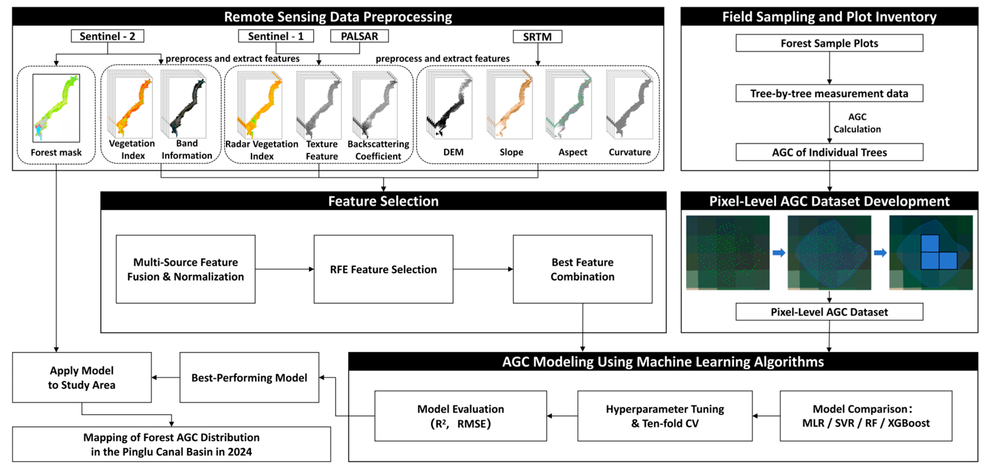
2. Materials and Methods
2.1. Study Area
2.2. Data and Methodology
2.2.1. Field Sampling and Plot Inventory
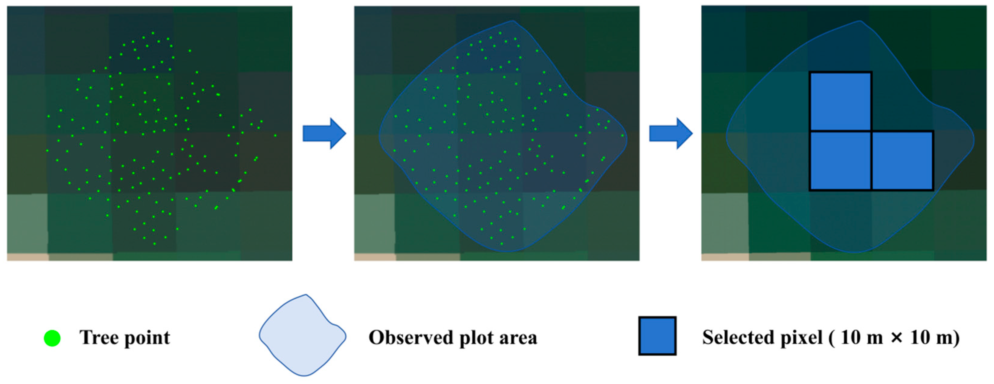
2.2.2. Pixel-Level AGC Dataset Development
2.2.3. Remote Sensing Data Preprocessing
- Optical Data
- 2.
- SAR Data
- 3.
- Topographic Data
- 4.
- Forest Mask
- 5.
- Historical Forest AGC Data
2.2.4. Feature Selection
2.2.5. Machine Learning Algorithms
2.2.6. Model Evaluation
3. Results
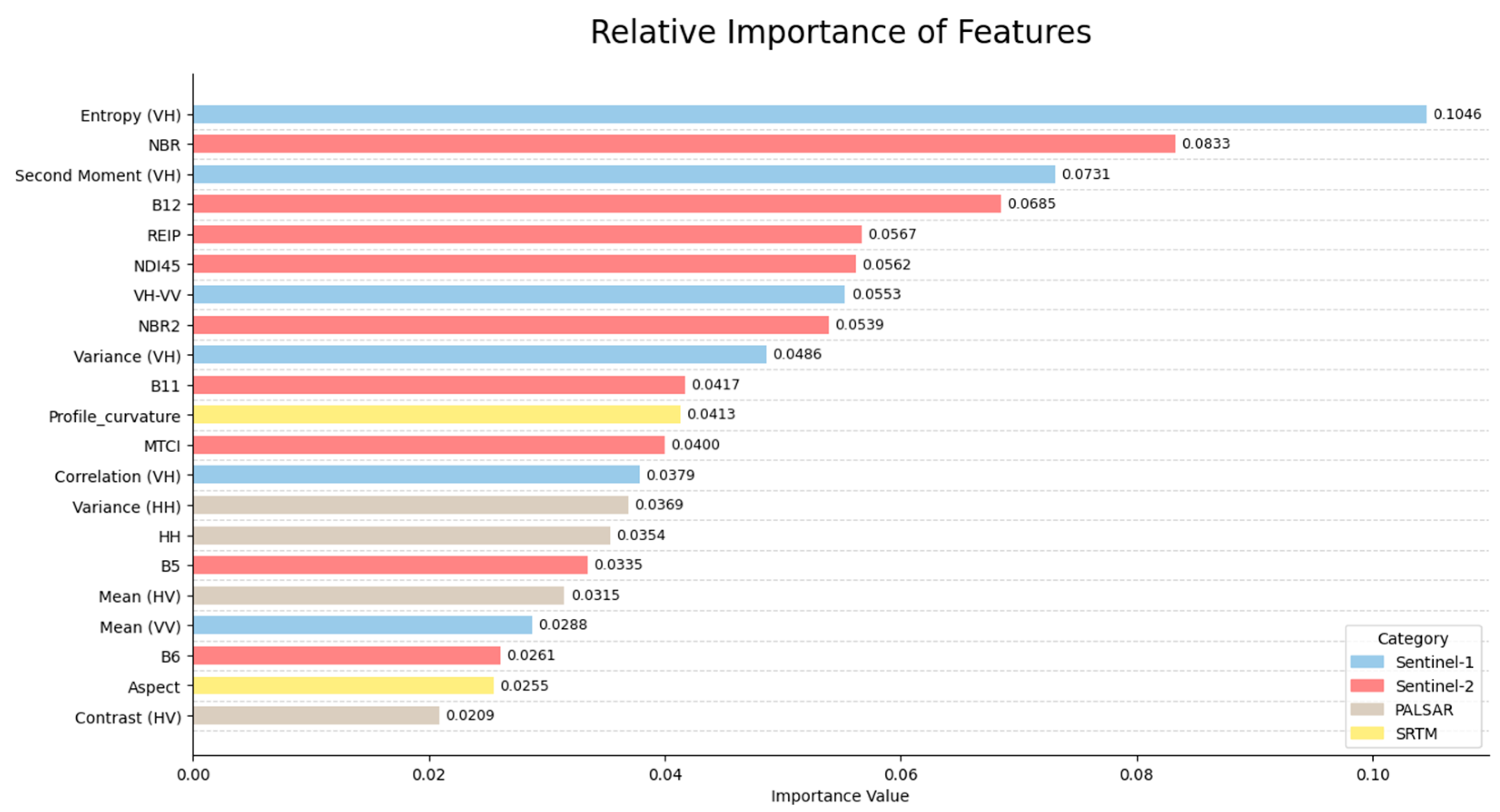
3.1. Data Collection Comparison and Feature Selection
3.2. Model Validation
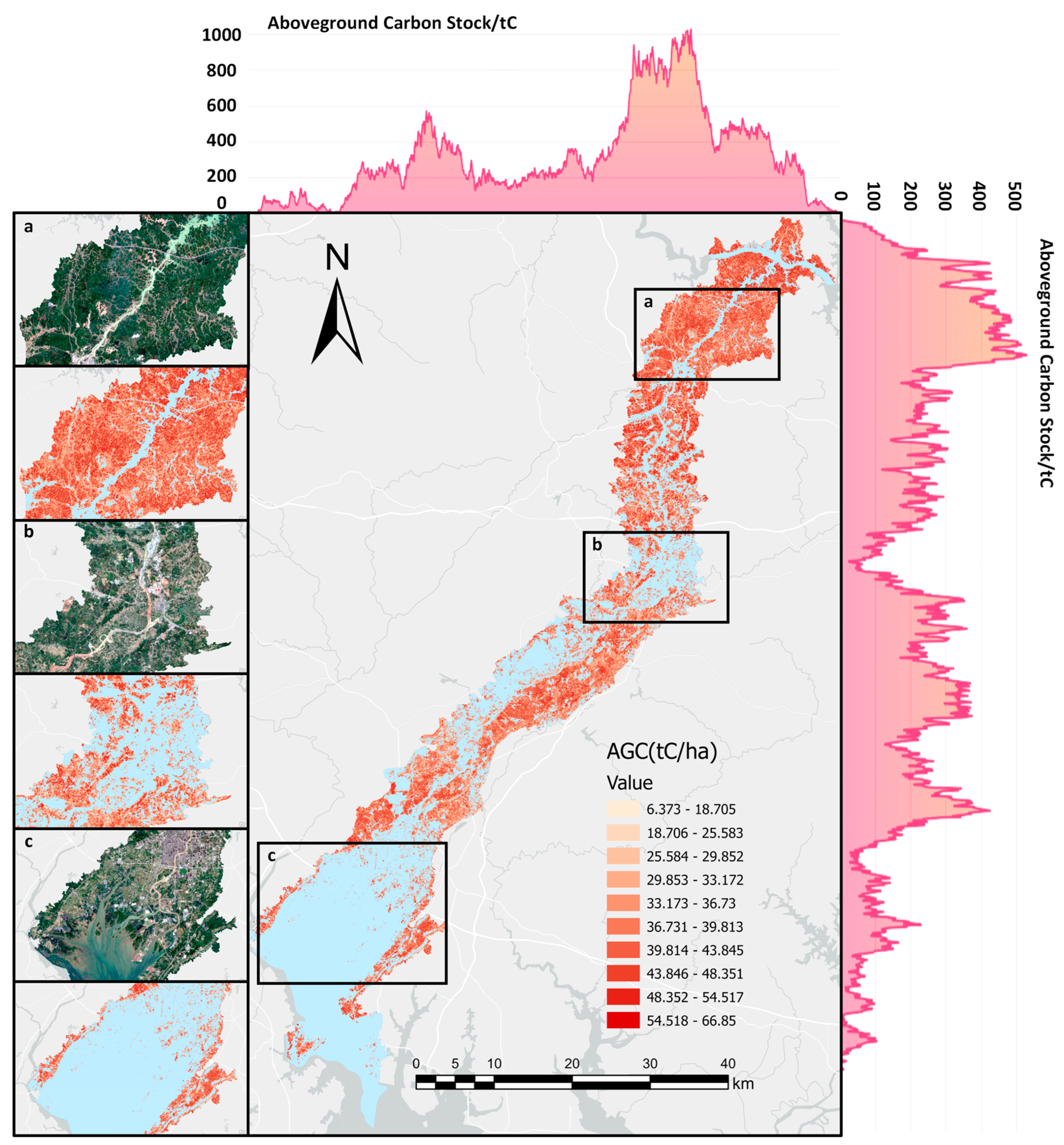
3.3. Spatial Distribution of Forest AGC in the Pinglu Canal Basin
4. Discussion
4.1. Addressing Spatial Heterogeneity in AGC Estimation with Advanced Sampling Methods
4.2. Relationship Between Multiple Source Factors and AGC
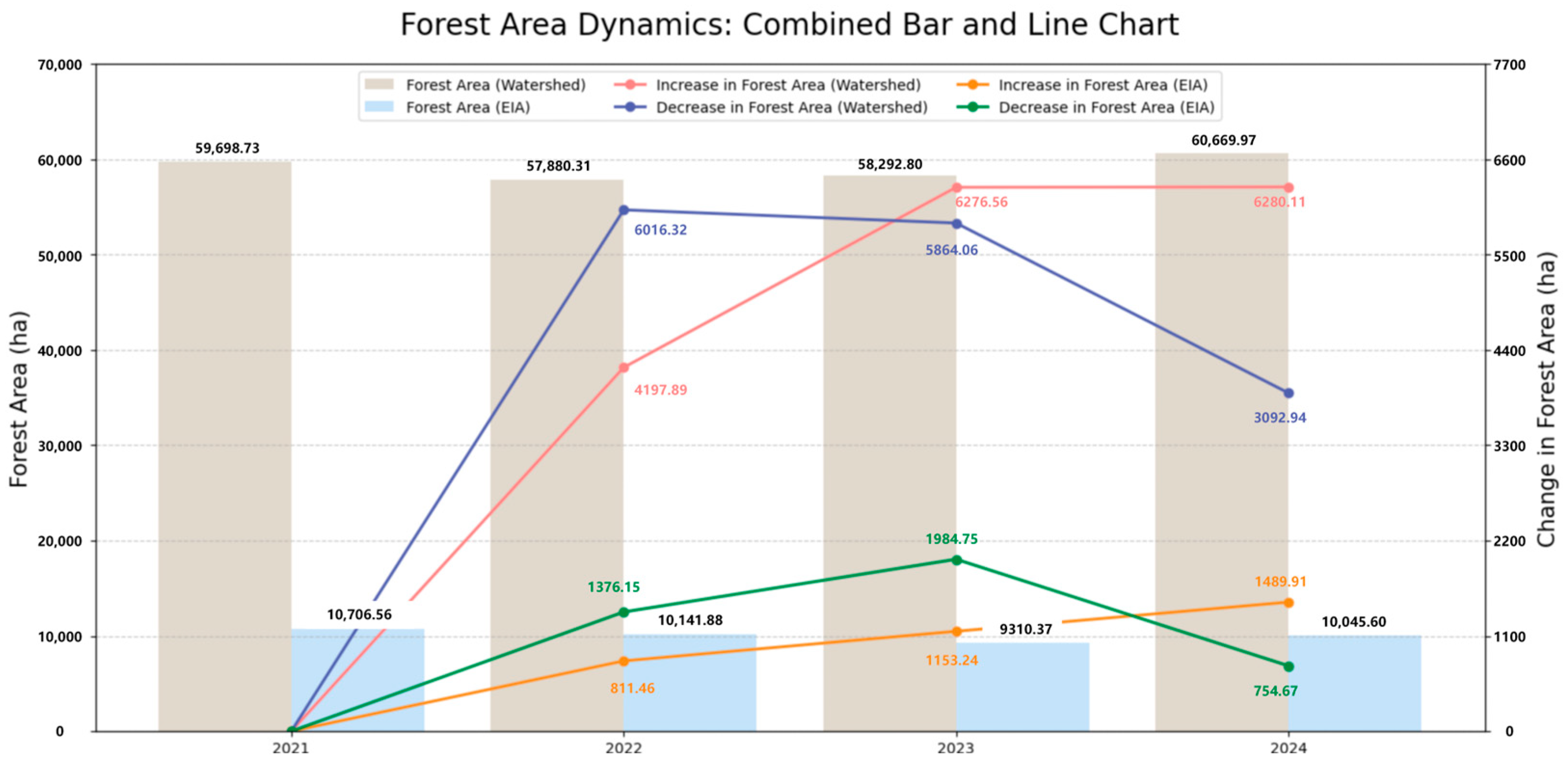
4.3. Analysis of Interannual Variation of AGC and Area Change in the Pinglu Canal Basin Forest
4.4. Method Comparison and Applicability
- (1)
- Spaceborne LiDAR-based modeling using GEDI or ICESat-2
- (2)
- High-resolution remote sensing modeling based on deep learning (e.g., CNN, Transformer)
- (3)
- Empirical regression models based on vegetation indices or topographic variables
5. Conclusions
- ●
- By integrating high-precision tree-level coordinate data obtained from RTK with Sentinel-2 imagery, this study developed a high-quality, pixel-level AGC dataset for the Pinglu Canal basin in 2024. This approach effectively addressed key challenges, including aligning field measurements with satellite data resolution and capturing spatial heterogeneity, thereby providing a robust foundation for accurate carbon stock estimation.
- ●
- Using RFE, we conducted effective feature selection and compared the estimation capabilities of different machine learning models. Among all tested data combinations and models, the hyperparameter-optimized RF model demonstrated the best performance in AGC estimation. Based on this, we generated a 10 m-resolution AGC spatial distribution map for the Pinglu Canal basin, offering a visual tool for carbon stock monitoring.
- ●
- By comparing the predicted 2024 AGC under a baseline scenario with the estimated AGC derived from multi-source remote sensing data and field survey data under actual conditions, we found that active forest conservation and vegetation restoration measures during the Pinglu Canal construction period resulted in better forest growth than natural growth scenarios. This highlights the potential for large-scale infrastructure projects to achieve a certain degree of harmony between construction and forest ecosystem protection.
Author Contributions
Funding
Data Availability Statement
Acknowledgments
Conflicts of Interest
Abbreviations
| AGC | Aboveground carbon stock |
| SAR | Synthetic Aperture Radar |
| SVR | Support Vector Regression |
| RF | Random Forest |
| RFE | Recursive Feature Elimination |
| MLR | Multiple Linear Regression |
| RTK | Real-Time Kinematic |
| GEE | Google Earth Engine |
| SRTM | Shuttle Radar Topography Mission |
| DEM | Digital Elevation Model |
| AGB | Aboveground biomass |
| R2 | Coefficient of determination |
| RMSE | Root mean square error |
| SVM | Support Vector Machine |
| EIA | Environmental Impact Assessment |
References
- Malhi, Y.; Franklin, J.; Seddon, N.; Solan, M.; Turner, M.G.; Field, C.B.; Knowlton, N. Climate change and ecosystems: Threats, opportunities and solutions. Philos. Trans. R. Soc. B Biol. Sci. 2020, 375, 20190104. [Google Scholar] [CrossRef] [PubMed]
- Pörtner, H.-O.; Scholes, R.J.; Agard, J.; Archer, E.; Arneth, A.; Bai, X.; Barnes, D.; Burrows, M.; Chan, L.; Cheung, W.L.W. Scientific Outcome of the IPBES-IPCC Co-Sponsored Workshop on Biodiversity and Climate Change; Intergovernmental Science-Policy Platform on Biodiversity and Ecosystem Services (IPBES): Bonn, Germany, 2021. [Google Scholar]
- Falkowski, P.; Scholes, R.J.; Boyle, E.; Canadell, J.; Canfield, D.; Elser, J.; Gruber, N.; Hibbard, K.; Högberg, P.; Linder, S. The global carbon cycle: A test of our knowledge of earth as a system. Science 2000, 290, 291–296. [Google Scholar] [CrossRef] [PubMed]
- Lorenz, K. Carbon Sequestration in Forest Ecosystems; Springer: Berlin/Heidelberg, Germany, 2010. [Google Scholar]
- Goetz, S.J.; Hansen, M.; Houghton, R.A.; Walker, W.; Laporte, N.; Busch, J. Measurement and monitoring needs, capabilities and potential for addressing reduced emissions from deforestation and forest degradation under REDD+. Environ. Res. Lett. 2015, 10, 123001. [Google Scholar] [CrossRef]
- Jenkins, M.; Schaap, B. Forest ecosystem services. In Background Analytical Study; United Nations Forum on Forests: New York, NY, USA, 2018; Volume 1. [Google Scholar]
- Wang, Y.; Guo, C.-H.; Chen, X.-J.; Jia, L.-Q.; Guo, X.-N.; Chen, R.-S.; Zhang, M.-S.; Chen, Z.-Y.; Wang, H.-D. Carbon peak and carbon neutrality in China: Goals, implementation path and prospects. China Geol. 2021, 4, 720–746. [Google Scholar] [CrossRef]
- FAO. Global Forest Resources Assessment 2020: Main Report; Food and Agriculture Organization of the United Nations: Rome, Italy, 2020. [Google Scholar]
- Zhou, Q.; Wang, L.; Tang, F.; Zhao, S.; Huang, N.; Zheng, K. Mapping spatial and temporal distribution information of plantations in Guangxi from 2000 to 2020. Front. Ecol. Evol. 2023, 11, 1201161. [Google Scholar] [CrossRef]
- Carse, A. Nature as infrastructure: Making and managing the Panama Canal watershed. Soc. Stud. Sci. 2012, 42, 539–563. [Google Scholar] [CrossRef]
- Condit, R.; Robinson, W.D.; Ibáñez, R.; Aguilar, S.; Sanjur, A.; Martínez, R.; Stallard, R.F.; García, T.; Angehr, G.R.; Petit, L. The Status of the Panama Canal Watershed and Its Biodiversity at the Beginning of the 21st Century: Long-term ecological studies reveal a diverse flora and fauna near the Panama Canal, harbored within a corridor of forest stretching from the Caribbean to the Pacific, but deforestation, land degradation, erosion, and overhunting remain threats. Bioscience 2001, 51, 389–398. [Google Scholar]
- Moreno, S.H. Impact of development on the Panama Canal environment. J. Interam. Stud. World Aff. 1993, 35, 129–150. [Google Scholar] [CrossRef]
- Wallander, S.; Lauterbach, S.; Anderson, K.; Chou, F.; Grossman, J.M.; Schloegel, C. Existing markets for ecosystem services in the Panama canal watershed. In Emerging Markets for Ecosystem Services; CRC Press: Boca Raton, FL, USA, 2021; pp. 311–336. [Google Scholar]
- Ibáñez, R.; Condit, R.; Angehr, G.; Aguilar, S.; GarcÍa, T.; MartÍnez, R.; Sanjur, A.; Stallard, R.; Wright, S.J.; Rand, A.S. An ecosystem report on the Panama Canal: Monitoring the status of the forest communities and the watershed. Environ. Monit. Assess. 2002, 80, 65–95. [Google Scholar] [CrossRef]
- Simonit, S.; Perrings, C. Bundling ecosystem services in the Panama Canal watershed. Proc. Natl. Acad. Sci. USA 2013, 110, 9326–9331. [Google Scholar] [CrossRef]
- Condit, R. Extracting environmental benefits from a new canal in Nicaragua: Lessons from Panama. PLoS Biol. 2015, 13, e1002208. [Google Scholar] [CrossRef]
- Gibbs, H.K.; Brown, S.; Niles, J.O.; Foley, J.A. Monitoring and estimating tropical forest carbon stocks: Making REDD a reality. Environ. Res. Lett. 2007, 2, 045023. [Google Scholar] [CrossRef]
- Segura, M.; Kanninen, M. Allometric models for tree volume and total aboveground biomass in a tropical humid forest in Costa Rica 1. Biotropica 2005, 37, 2–8. [Google Scholar] [CrossRef]
- Lu, D.; Chen, Q.; Wang, G.; Liu, L.; Li, G.; Moran, E. A survey of remote sensing-based aboveground biomass estimation methods in forest ecosystems. Int. J. Digit. Earth 2016, 9, 63–105. [Google Scholar] [CrossRef]
- Halme, E.; Pellikka, P.; Mottus, M. Utility of hyperspectral compared to multispectral remote sensing data in estimating forest biomass and structure variables in Finnish boreal forest. Int. J. Appl. Earth Obs. Geoinf. 2019, 83, 101942. [Google Scholar] [CrossRef]
- Li, W.; Zhang, Y.; Zhang, J.; Chen, H.; Chen, E.; Zhao, L.; Zhao, D. Tropical forest AGB estimation based on structure parameters extracted by TomoSAR. Int. J. Appl. Earth Obs. Geoinf. 2023, 121, 103369. [Google Scholar] [CrossRef]
- Puliti, S.; Breidenbach, J.; Schumacher, J.; Hauglin, M.; Klingenberg, T.F.; Astrup, R. Above-ground biomass change estimation using national forest inventory data with Sentinel-2 and Landsat. Remote Sens. Environ. 2021, 265, 112644. [Google Scholar] [CrossRef]
- Verly, O.M.; Leite, R.V.; da Silva Tavares-Junior, I.; da Rocha, S.J.S.S.; Leite, H.G.; Gleriani, J.M.; Rufino, M.P.M.X.; de Fatima Silva, V.; Torres, C.M.M.E.; Plata-Rueda, A. Atlantic forest woody carbon stock estimation for different successional stages using Sentinel-2 data. Ecol. Indic. 2023, 146, 109870. [Google Scholar] [CrossRef]
- Schmitt, M.; Zhu, X.X. Data fusion and remote sensing: An ever-growing relationship. IEEE Geosci. Remote Sens. Mag. 2016, 4, 6–23. [Google Scholar] [CrossRef]
- Sinha, S.; Mohan, S.; Das, A.; Sharma, L.; Jeganathan, C.; Santra, A.; Santra Mitra, S.; Nathawat, M. Multi-sensor approach integrating optical and multi-frequency synthetic aperture radar for carbon stock estimation over a tropical deciduous forest in India. Carbon Manag. 2020, 11, 39–55. [Google Scholar] [CrossRef]
- Yang, Q.; Niu, C.; Liu, X.; Feng, Y.; Ma, Q.; Wang, X.; Tang, H.; Guo, Q. Mapping high-resolution forest aboveground biomass of China using multisource remote sensing data. GISci. Remote Sens. 2023, 60, 2203303. [Google Scholar] [CrossRef]
- Kanga, S. Advancements in remote sensing tools for forestry analysis. Sustain. For. 2023, 6, 2269. [Google Scholar] [CrossRef]
- Li, J.; Bao, W.; Wang, X.; Song, Y.; Liao, T.; Xu, X.; Guo, M. Estimating Aboveground Biomass of Boreal Forests in Northern China Using Multiple Data sets. IEEE Trans. Geosci. Remote Sens. 2024, 62, 4408410. [Google Scholar]
- Cosenza, D.N.; Korhonen, L.; Maltamo, M.; Packalen, P.; Strunk, J.L.; Næsset, E.; Gobakken, T.; Soares, P.; Tomé, M. Comparison of linear regression, k-nearest neighbour and random forest methods in airborne laser-scanning-based prediction of growing stock. Forestry 2021, 94, 311–323. [Google Scholar] [CrossRef]
- Mohammadi, J.; Shataee, S.; Babanezhad, M. Estimation of forest stand volume, tree density and biodiversity using Landsat ETM+ Data, comparison of linear and regression tree analyses. Procedia Environ. Sci. 2011, 7, 299–304. [Google Scholar] [CrossRef]
- Georgopoulos, N.; Gitas, I.Z.; Stefanidou, A.; Korhonen, L.; Stavrakoudis, D. Estimation of Individual Tree Stem Biomass in an Uneven-Aged Structured Coniferous Forest Using Multispectral LiDAR Data. Remote Sens. 2021, 13, 4827. [Google Scholar] [CrossRef]
- Singh, C.; Karan, S.K.; Sardar, P.; Samadder, S.R. Remote sensing-based biomass estimation of dry deciduous tropical forest using machine learning and ensemble analysis. J. Environ. Manag. 2022, 308, 114639. [Google Scholar] [CrossRef]
- Bergstra, J.; Bardenet, R.; Bengio, Y.; Kégl, B. Algorithms for hyper-parameter optimization. In Proceedings of the 25th International Conference on Neural Information Processing Systems, Granada, Spain, 12–15 December 2011; Volume 24. [Google Scholar]
- Jung, J.; Kim, S.; Hong, S.; Kim, K.; Kim, E.; Im, J.; Heo, J. Effects of national forest inventory plot location error on forest carbon stock estimation using k-nearest neighbor algorithm. ISPRS J. Photogramm. Remote Sens. 2013, 81, 82–92. [Google Scholar] [CrossRef]
- Urbazaev, M.; Thiel, C.; Cremer, F.; Dubayah, R.; Migliavacca, M.; Reichstein, M.; Schmullius, C. Estimation of forest aboveground biomass and uncertainties by integration of field measurements, airborne LiDAR, and SAR and optical satellite data in Mexico. Carbon Balance Manag. 2018, 13, 5. [Google Scholar] [CrossRef]
- Huang, L.; Huang, Z.; Zhou, W.; Wu, S.; Li, X.; Mao, F.; Song, M.; Zhao, Y.; Lv, L.; Yu, J. Landsat-based spatiotemporal estimation of subtropical forest aboveground carbon storage using machine learning algorithms with hyperparameter tuning. Front. Plant Sci. 2024, 15, 1421567. [Google Scholar] [CrossRef]
- Zhang, Y.; He, B.; Chen, R.; Zhang, H.; Fan, C.; Yin, J.; Li, Y. The potential of optical and SAR time-series data for the improvement of aboveground biomass carbon estimation in Southwestern China’s evergreen coniferous forests. GISci. Remote Sens. 2024, 61, 2345438. [Google Scholar] [CrossRef]
- Ecke, S.; Stehr, F.; Frey, J.; Tiede, D.; Dempewolf, J.; Klemmt, H.-J.; Endres, E.; Seifert, T. Towards operational UAV-based forest health monitoring: Species identification and crown condition assessment by means of deep learning. Comput. Electron. Agric. 2024, 219, 108785. [Google Scholar] [CrossRef]
- Qin, H.; Zhou, W.; Yao, Y.; Wang, W. Individual tree segmentation and tree species classification in subtropical broadleaf forests using UAV-based LiDAR, hyperspectral, and ultrahigh-resolution RGB data. Remote Sens. Environ. 2022, 280, 113143. [Google Scholar] [CrossRef]
- Li, H.; Hiroshima, T.; Li, X.; Hayashi, M.; Kato, T. High-resolution mapping of forest structure and carbon stock using multi-source remote sensing data in Japan. Remote Sens. Environ. 2024, 312, 114322. [Google Scholar] [CrossRef]
- Liu, S.; Wang, H.; Hu, Y.; Zhang, M.; Zhu, Y.; Wang, Z.; Li, D.; Yang, M.; Wang, F. Land use and land cover mapping in China using multimodal fine-grained dual network. IEEE Trans. Geosci. Remote Sens. 2023, 61, 4405219. [Google Scholar] [CrossRef]
- Xu, H.; Man, Y.; Yang, M.; Wu, J.; Zhang, Q.; Wang, J. Analytical Insight of Earth: A Cloud-Platform of Intelligent Computing for Geospatial Big Data. arXiv 2023, arXiv:2312.16385. [Google Scholar]
- Zhao, C.; Qin, C.-Z. 10-m-resolution mangrove maps of China derived from multi-source and multi-temporal satellite observations. ISPRS J. Photogramm. Remote Sens. 2020, 169, 389–405. [Google Scholar] [CrossRef]
- Chen, Y.; Feng, X.; Fu, B.; Ma, H.; Zohner, C.M.; Crowther, T.W.; Huang, Y.; Wu, X.; Wei, F. Maps with 1 km resolution reveal increases in above-and belowground forest biomass carbon pools in China over the past 20 years. Earth Syst. Sci. Data 2023, 15, 897–910. [Google Scholar] [CrossRef]
- Li, Y.; Li, C.; Li, M.; Liu, Z. Influence of variable selection and forest type on forest aboveground biomass estimation using machine learning algorithms. Forests 2019, 10, 1073. [Google Scholar] [CrossRef]
- Cabello-Solorzano, K.; Ortigosa de Araujo, I.; Peña, M.; Correia, L.; Tallón-Ballesteros, A.J. The impact of data normalization on the accuracy of machine learning algorithms: A comparative analysis. In Proceedings of the International Conference on Soft Computing Models in Industrial and Environmental Applications, Salamanca, Spain, 5–7 September 2023; pp. 344–353. [Google Scholar]
- Wang, C.; Zhang, W.; Ji, Y.; Marino, A.; Li, C.; Wang, L.; Zhao, H.; Wang, M. Estimation of Aboveground Biomass for Different Forest Types Using Data from Sentinel-1, Sentinel-2, ALOS PALSAR-2, and GEDI. Forests 2024, 15, 215. [Google Scholar] [CrossRef]
- Wang, Z.; Zhang, Y.; Li, F.; Gao, W.; Guo, F.; Li, Z.; Yang, Z. Regional mangrove vegetation carbon stocks predicted integrating UAV-LiDAR and satellite data. J. Environ. Manag. 2024, 368, 122101. [Google Scholar] [CrossRef]
- Guyon, I.; Weston, J.; Barnhill, S.; Vapnik, V. Gene selection for cancer classification using support vector machines. Mach. Learn. 2002, 46, 389–422. [Google Scholar] [CrossRef]
- Breiman, L. Random forests. Mach. Learn. 2001, 45, 5–32. [Google Scholar] [CrossRef]
- Uyanık, G.K.; Güler, N. A study on multiple linear regression analysis. Procedia Soc. Behav. Sci. 2013, 106, 234–240. [Google Scholar] [CrossRef]
- Awad, M.; Khanna, R.; Awad, M.; Khanna, R. Support vector regression. In Efficient Learning Machines: Theories, Concepts, and Applications for Engineers and System Designers; Apress: New York, NY, USA, 2015; pp. 67–80. [Google Scholar]
- Chen, T.; Guestrin, C. Xgboost: A scalable tree boosting system. In Proceedings of the 22nd ACM SIGKDD International Conference on Knowledge Discovery and Data Mining, San Francisco, CA, USA, 13–17 August 2016; pp. 785–794. [Google Scholar]
- Cheng, F.; Ou, G.; Wang, M.; Liu, C. Remote sensing estimation of forest carbon stock based on machine learning algorithms. Forests 2024, 15, 681. [Google Scholar] [CrossRef]
- Ding, X.; Liu, J.; Yang, F.; Cao, J. Random radial basis function kernel-based support vector machine. J. Frankl. Inst. 2021, 358, 10121–10140. [Google Scholar] [CrossRef]
- Jiang, W.; Zhang, L.; Zhang, X.; Gao, S.; Gao, H.; Sun, L.; Yan, G. Multi-Decision Vector Fusion Model for Enhanced Mapping of Aboveground Biomass in Subtropical Forests Integrating Sentinel-1, Sentinel-2, and Airborne LiDAR Data. Remote Sens. 2025, 17, 1285. [Google Scholar] [CrossRef]
- Kohavi, R. A study of cross-validation and bootstrap for accuracy estimation and model selection. In Proceedings of the International Joint Confeence on Artificial Intelligence, Montreal, QC, Canada, 20–25 August 1995; pp. 1137–1145. [Google Scholar]
- Wang, X.; Jiao, H. Spatial scaling of forest aboveground biomass using multi-source remote sensing data. IEEE Access 2020, 8, 178870–178885. [Google Scholar] [CrossRef]
- Yan, X.; Li, J.; Smith, A.R.; Yang, D.; Ma, T.; Su, Y.; Shao, J. Evaluation of machine learning methods and multi-source remote sensing data combinations to construct forest above-ground biomass models. Int. J. Digit. Earth 2023, 16, 4471–4491. [Google Scholar] [CrossRef]
- Yan, L.; Roy, D.; Li, Z.; Zhang, H.; Huang, H. Sentinel-2A multi-temporal misregistration characterization and an orbit-based sub-pixel registration methodology. Remote Sens. Environ. 2018, 215, 495–506. [Google Scholar] [CrossRef]
- Dai, W.; Fu, W.; Jiang, P.; Zhao, K.; Li, Y.; Tao, J. Spatial pattern of carbon stocks in forest ecosystems of a typical subtropical region of southeastern China. For. Ecol. Manag. 2018, 409, 288–297. [Google Scholar] [CrossRef]
- Lin, Z.; Chao, L.; Wu, C.; Hong, W.; Hong, T.; Hu, X. Spatial analysis of carbon storage density of mid-subtropical forests using geostatistics: A case study in Jiangle County, southeast China. Acta Geochim. 2018, 37, 90–101. [Google Scholar] [CrossRef]
- Fuchs, H.; Magdon, P.; Kleinn, C.; Flessa, H. Estimating aboveground carbon in a catchment of the Siberian forest tundra: Combining satellite imagery and field inventory. Remote Sens. Environ. 2009, 113, 518–531. [Google Scholar] [CrossRef]
- Xu, D.; Wang, H.; Xu, W.; Luan, Z.; Xu, X. LiDAR applications to estimate forest biomass at individual tree scale: Opportunities, challenges and future perspectives. Forests 2021, 12, 550. [Google Scholar] [CrossRef]
- Liao, K.; Li, Y.; Zou, B.; Li, D.; Lu, D. Examining the role of UAV Lidar data in improving tree volume calculation accuracy. Remote Sens. 2022, 14, 4410. [Google Scholar] [CrossRef]
- Mohammed, K.; Kpienbaareh, D.; Wang, J.; Goldblum, D.; Luginaah, I.; Lupafya, E.; Dakishoni, L. Synthesizing Local Capacities, Multi-Source Remote Sensing and Meta-Learning to Optimize Forest Carbon Assessment in Data-Poor Regions. Remote Sens. 2025, 17, 289. [Google Scholar] [CrossRef]
- Cheekhooree, K. Canopy Height Assessment in South Australian Pinus Radiata Plantations Using Sentinel-1: A Comparative Analysis Between INSAR and Machine Learning Algorithms. Master’s Thesis, Flinders University, College of Science and Engineering, Bedford Park, Australia, 2024. [Google Scholar]
- Lausch, A.; Erasmi, S.; King, D.J.; Magdon, P.; Heurich, M. Understanding forest health with remote sensing-part I—A review of spectral traits, processes and remote-sensing characteristics. Remote Sens. 2016, 8, 1029. [Google Scholar] [CrossRef]
- Datt, B. Remote Sensing of Foliar Biochemistry and Biophysical Properties in Eucalyptus Species: Application of High Spectral Resolution Reflectance Measurements. Ph.D. Thesis, UNSW Sydney, Sydney, Australia, 1999. [Google Scholar]
- Sharma, C.; Gairola, S.; Baduni, N.; Ghildiyal, S.; Suyal, S. Variation in carbon stocks on different slope aspects in seven major forest types of temperate region of Garhwal Himalaya, India. J. Biosci. 2011, 36, 701–708. [Google Scholar] [CrossRef]
- Singh, S. Understanding the role of slope aspect in shaping the vegetation attributes and soil properties in Montane ecosystems. Trop. Ecol. 2018, 59, 417–430. [Google Scholar]
- Xu, W.; Cheng, Y.; Luo, M.; Mai, X.; Wang, W.; Zhang, W.; Wang, Y. Progress and Limitations in Forest Carbon Stock Estimation Using Remote Sensing Technologies: A Comprehensive Review. Forests 2025, 16, 449. [Google Scholar] [CrossRef]
- Zhang, X.; Shen, J.; Sun, F.; Wang, S. Spatial-temporal evolution and influencing factors analysis of ecosystem services value: A case study in sunan canal basin of jiangsu province, eastern China. Remote Sens. 2022, 15, 112. [Google Scholar] [CrossRef]
- Zhao, H.; Wu, C.; Wang, X. Large-scale forest conservation and restoration programs significantly contributed to land surface greening in China. Environ. Res. Lett. 2022, 17, 024023. [Google Scholar] [CrossRef]
- Lu, F.; Hu, H.; Sun, W.; Zhu, J.; Liu, G.; Zhou, W.; Zhang, Q.; Shi, P.; Liu, X.; Wu, X. Effects of national ecological restoration projects on carbon sequestration in China from 2001 to 2010. Proc. Natl. Acad. Sci. USA 2018, 115, 4039–4044. [Google Scholar] [CrossRef]
- Mitra, S.; Madhuvanthi, S.; Sabumon, P. Integrating Green Infrastructure. In Nature-Based Solutions in Achieving Sustainable Development Goals; Springer: Cham, Switzerland, 2024; p. 167. [Google Scholar]
- Neuenschwander, A.; Duncanson, L.; Montesano, P.; Minor, D.; Guenther, E.; Hancock, S.; Wulder, M.; White, J.C.; Purslow, M.; Thomas, N. Towards global spaceborne lidar biomass: Developing and applying boreal forest biomass models for ICESat-2 laser altimetry data. Sci. Remote Sens. 2024, 10, 100150. [Google Scholar] [CrossRef]
- Zhang, F.; Tian, X.; Zhang, H.; Jiang, M. Estimation of aboveground carbon density of forests using deep learning and multisource remote sensing. Remote Sens. 2022, 14, 3022. [Google Scholar] [CrossRef]
- Poudel, A.; Shrestha, H.L.; Mahat, N.; Sharma, G.; Aryal, S.; Kalakheti, R.; Lamsal, B. Modeling and Mapping of Aboveground Biomass and Carbon Stock Using Sentinel-2 Imagery in Chure Region, Nepal. Int. J. For. Res. 2023, 2023, 5553957. [Google Scholar] [CrossRef]
- Shumway, R.H.; Stoffer, D.S.; Shumway, R.H.; Stoffer, D.S. ARIMA models. In Time Series Analysis and Its Applications: With R Examples; Springer: Berlin/Heidelberg, Germany, 2017; pp. 75–163. [Google Scholar]
- Greff, K.; Srivastava, R.K.; Koutník, J.; Steunebrink, B.R.; Schmidhuber, J. LSTM: A search space odyssey. IEEE Trans. Neural Netw. Learn. Syst. 2016, 28, 2222–2232. [Google Scholar] [CrossRef]


| Sensor | Bands, Indices or Texture Features | Description | |
|---|---|---|---|
| Sentinel-2 | Multispectral bands | B2 | 490 nm, blue |
| B3 | 560 nm, green | ||
| B4 | 665 nm, red | ||
| B5 | 705 nm, red edge1 | ||
| B6 | 740 nm, red edge2 | ||
| B7 | 783 nm, red edge3 | ||
| B8 | 842 nm, NIR | ||
| B8A | 865 nm, red edge4 | ||
| B11 | 1610 nm, SWIR | ||
| B12 | 2190 nm, SWIR | ||
| Vegetation indices | ARVI, CVI, DVI, EVI, GNDVI, GRVI, IPVI, LAI, MSAVI, MTCI, NBR, NBR2, NDI45, NDVI, NDWI, REIP, SAVI, WDVI | All 18 vegetation indices are calculated based on multispectral bands. | |
| Sentinel-1 | Polarization | VV | Vertical–vertical polarization |
| VH | Vertical–horizonal polarization | ||
| Indices | VV + VH | All 5 indices are calculated based on the dual-polarization backscatter coefficient (VV and VH). | |
| VV − VH | |||
| VV/VH | |||
| VH/VV | |||
| (VV − VH)/(VV + VH) | |||
| Texture feature | Mean | Texture features are extracted from dual-polarization backscatter coefficients (VV and VH) using GLCM with a 7 × 7 pixel window. | |
| Variance | |||
| Homogeneity | |||
| Contrast | |||
| Dissimilarity | |||
| Entropy | |||
| Second moment | |||
| Correlation | |||
| PALSAR | Polarization | HH | Horizontal–horizontal polarization |
| HV | Horizontal–vertical polarization | ||
| Indices | HH + HV | All 5 indices are calculated based on the dual-polarization backscatter coefficient (HH and HV). | |
| HH − HV | |||
| HH/HV | |||
| HV/HH | |||
| (HH − HV)/(HH + HV) | |||
| Texture feature | Same as Sentinel-1 | Texture features are extracted from dual-polarization backscatter coefficients (HH and HV) using GLCM with a 7 × 7 pixel window. | |
| SRTM | DEM | Elevation | Height above sea level |
| Indices | Slope | All 5 indices are all calculated using standard terrain analysis algorithms in GIS software (ArcGIS Pro, version 3.0.1). | |
| Aspect | |||
| Curvature | |||
| Plan curvature | |||
| Profile curvature |
| Sensor | Number | R2 | RMSE | Selected | R2 | RMSE |
|---|---|---|---|---|---|---|
| S2 | 28 | 0.441 | 19.370 | 24 | 0.446 | 19.281 |
| S1 | 23 | 0.577 | 17.723 | 22 | 0.580 | 17.662 |
| PALSAR | 23 | 0.356 | 19.113 | 11 | 0.360 | 19.053 |
| SRTM | 6 | 0.342 | 24.017 | 4 | 0.361 | 21.696 |
| S2 + S1 | 51 | 0.601 | 16.361 | 42 | 0.610 | 16.190 |
| S2 + PALSAR | 51 | 0.494 | 19.217 | 28 | 0.503 | 19.063 |
| S2 + SRTM | 34 | 0.495 | 18.160 | 14 | 0.506 | 17.949 |
| S1 + PALSAR | 46 | 0.601 | 17.482 | 45 | 0.608 | 17.555 |
| S1 + SRTM | 29 | 0.615 | 16.897 | 22 | 0.630 | 16.569 |
| PALSAR + SRTM | 29 | 0.422 | 20.130 | 28 | 0.431 | 19.979 |
| S2 + S1 + PALSAR | 74 | 0.621 | 12.634 | 50 | 0.658 | 11.999 |
| S2 + S1 + SRTM | 57 | 0.640 | 13.373 | 37 | 0.655 | 13.090 |
| S2 + PALSAR + SRTM | 57 | 0.499 | 19.298 | 41 | 0.520 | 18.887 |
| S1 + PALSAR + SRTM | 52 | 0.616 | 14.067 | 51 | 0.632 | 13.613 |
| ALL | 80 | 0.647 | 12.191 | 21 | 0.659 | 11.980 |
| Data Source | Key Variables | Importance/ Feature Role | Typical Forest Types | Correlation with AGC | Notes/ Interpretation |
|---|---|---|---|---|---|
| Sentinel-1 | Entropy (VH), VH-VV, second moment (VH) | High—captures structure and texture | Masson pine | Moderate to high | Key radar variables for structure; performs well in high-biomass and coniferous areas |
| Sentinel-2 | NBR, REIP, B12 | High—spectral condition indicators | Eucalyptus | Moderate to high | Sensitive to canopy health and chlorophyll; good in low–medium biomass zones |
| PALSAR | Variance (HH), HH, mean (HV) | Medium—supplementary structure | Mixed forests | Low to moderate | Adds heterogeneity info, useful in mixed stands |
| SRTM | Profile_curvature, aspect | Low—topographic background | Mixed forests | Weak | Reflects terrain influence; steep areas may limit carbon accumulation |
Disclaimer/Publisher’s Note: The statements, opinions and data contained in all publications are solely those of the individual author(s) and contributor(s) and not of MDPI and/or the editor(s). MDPI and/or the editor(s) disclaim responsibility for any injury to people or property resulting from any ideas, methods, instructions or products referred to in the content. |
© 2025 by the authors. Licensee MDPI, Basel, Switzerland. This article is an open access article distributed under the terms and conditions of the Creative Commons Attribution (CC BY) license (https://creativecommons.org/licenses/by/4.0/).
Share and Cite
Xu, W.; Mai, X.; Deng, S.; Wang, W.; Wu, W.; Zhang, W.; Wang, Y. High-Resolution Mapping and Impact Assessment of Forest Aboveground Carbon Stock in the Pinglu Canal Basin: A Multi-Sensor and Multi-Model Machine Learning Approach. Forests 2025, 16, 1130. https://doi.org/10.3390/f16071130
Xu W, Mai X, Deng S, Wang W, Wu W, Zhang W, Wang Y. High-Resolution Mapping and Impact Assessment of Forest Aboveground Carbon Stock in the Pinglu Canal Basin: A Multi-Sensor and Multi-Model Machine Learning Approach. Forests. 2025; 16(7):1130. https://doi.org/10.3390/f16071130
Chicago/Turabian StyleXu, Weifeng, Xuzhi Mai, Songwen Deng, Wenhuan Wang, Wenqian Wu, Wei Zhang, and Yinghui Wang. 2025. "High-Resolution Mapping and Impact Assessment of Forest Aboveground Carbon Stock in the Pinglu Canal Basin: A Multi-Sensor and Multi-Model Machine Learning Approach" Forests 16, no. 7: 1130. https://doi.org/10.3390/f16071130
APA StyleXu, W., Mai, X., Deng, S., Wang, W., Wu, W., Zhang, W., & Wang, Y. (2025). High-Resolution Mapping and Impact Assessment of Forest Aboveground Carbon Stock in the Pinglu Canal Basin: A Multi-Sensor and Multi-Model Machine Learning Approach. Forests, 16(7), 1130. https://doi.org/10.3390/f16071130