GIS-Based Multi-Criteria Analysis for Urban Afforestation Planning in Semi-Arid Cities
Abstract
1. Introduction
2. Data and Methodology
2.1. Study Area
2.2. Data Acquisition and Preprocessing
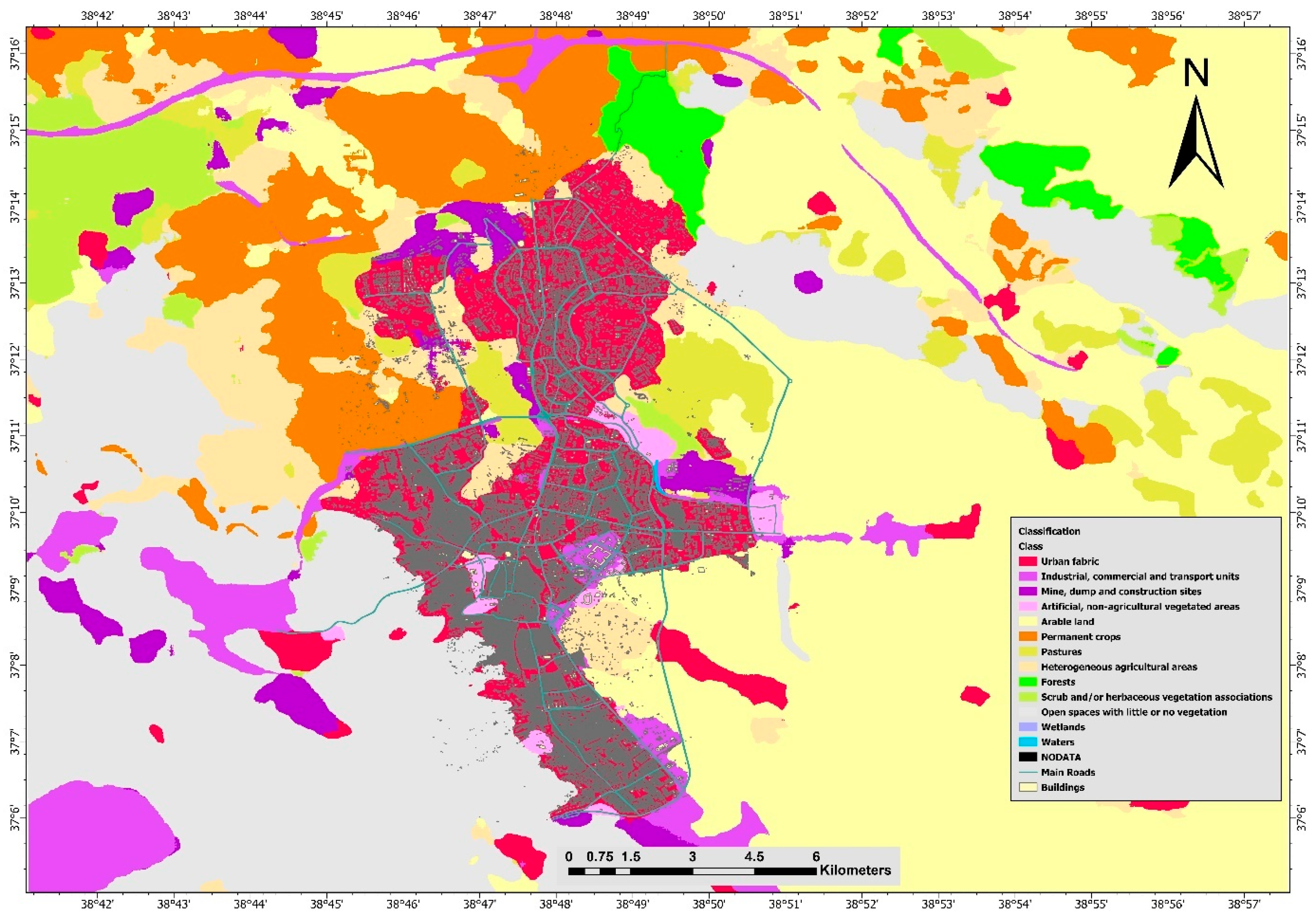
2.3. Land Use and Land Cover Classification
2.4. Land Surface Temperature Calculation
2.5. Criteria Layer Development
2.6. Analytical Hierarchy Process
2.7. Weighted Overlay and Final Suitability Mapping
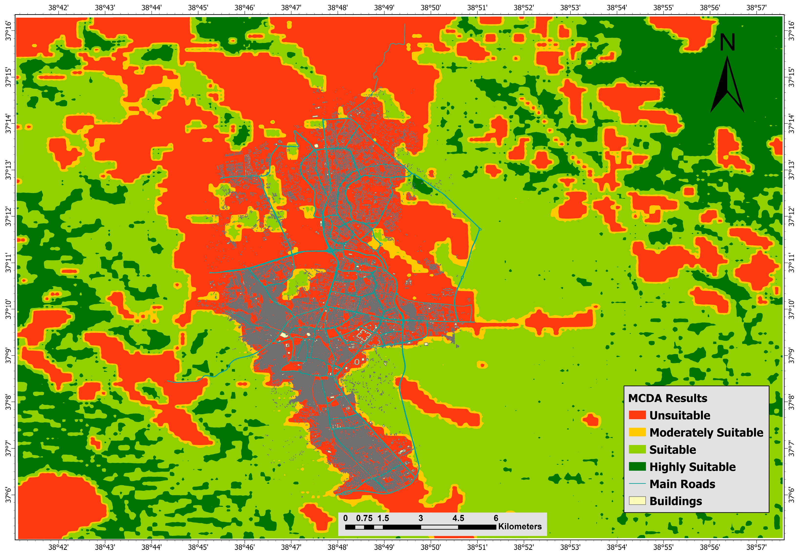
- Highly suitable (0.75–1.00)
- Suitable (0.50–0.75)
- Moderately suitable (0.25–0.50)
- Unsuitable (0.00–0.25)
3. Results
3.1. Spatial Patterns of Individual Criteria
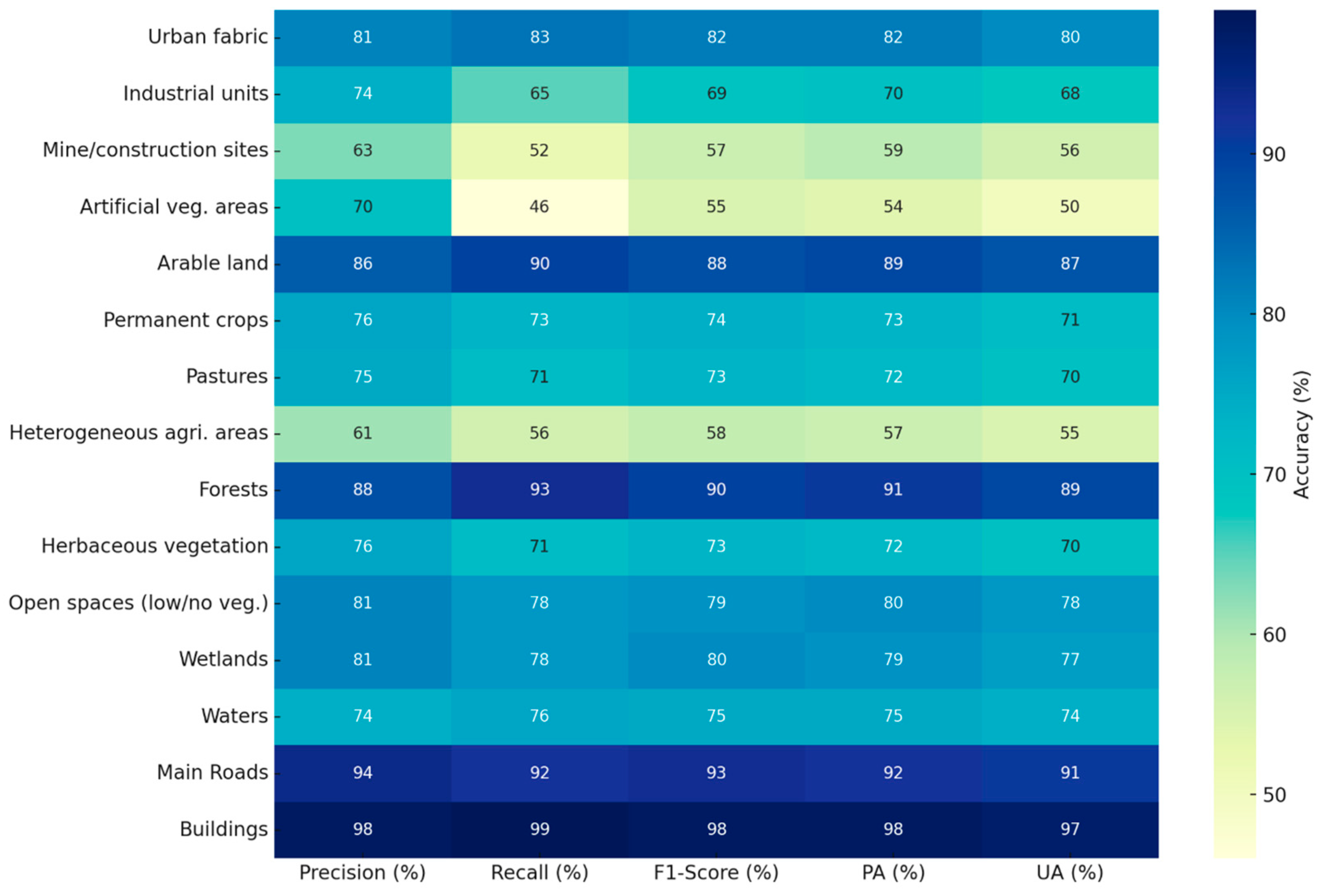
- Scrublands: Precision = 76%, Recall = 71%, F1-score = 73%
- Open Land with Little or No Vegetation: Precision = 81%, Recall = 78%, F1-score = 79%
- Heterogeneous Agricultural Areas: Precision = 61%, Recall = 56%, F1-score = 58%
3.2. Multi-Criteria Decision Analysis Results
4. Discussion
5. Conclusions
Author Contributions
Funding
Data Availability Statement
Acknowledgments
Conflicts of Interest
References
- Pamukcu-Albers, P.; Ugolini, F.; La Rosa, D.; Grădinaru, S.R.; Azevedo, J.C.; Wu, J. Building green infrastructure to enhance urban resilience to climate change and pandemics. Landsc. Ecol. 2021, 36, 665–673. [Google Scholar] [CrossRef] [PubMed]
- Yu, H.; Zahidi, I.; Fai, C.M. Mitigating Urban Heat Islands (UHI) Through Vegetation Restoration: Insights From Mining Communities. Glob. Chall. 2025, 9, 2400288. [Google Scholar] [CrossRef]
- Shen, X.; Chen, M.; Li, X.; Gao, S.; Yang, Q.; Wen, Y.; Sun, Q. Advancing climate resilience through a geo-design framework: Strengthening urban and community forestry for sustainable environmental design. J. For. Res. 2024, 35, 117. [Google Scholar] [CrossRef]
- Sharma, G.; Morgenroth, J.; Richards, D.R.; Ye, N. Advancing urban forest and ecosystem service assessment through the integration of remote sensing and i-Tree Eco: A systematic review. Urban For. Urban Green. 2025, 81, 128659. [Google Scholar] [CrossRef]
- Yin, S.; Chen, W.Y.; Liu, C. Urban forests as a strategy for transforming towards healthy cities. Urban For. Urban Green. 2023, 81, 127871. [Google Scholar] [CrossRef]
- Singh, H. Urban Forests, Climate Change and Environmental Pollution: Physio-Biochemical and Molecular Perspectives to Enhance Urban Resilience; Springer Nature: Cham, Switzerland, 2024. [Google Scholar]
- Wolf, K.L.; Lam, S.T.; McKeen, J.K.; Richardson, G.R.; van Den Bosch, M.; Bardekjian, A.C. Urban trees and human health: A scoping review. Int. J. Environ. Res. Public Health 2020, 17, 4371. [Google Scholar] [CrossRef]
- Liang, D.; Huang, G. Influence of urban tree traits on their ecosystem services: A literature review. Land 2023, 12, 1699. [Google Scholar] [CrossRef]
- Cardinali, M.; Beenackers, M.A.; Fleury-Bahi, G.; Bodénan, P.; Petrova, M.T.; van Timmeren, A.; Pottgiesser, U. Examining green space characteristics for social cohesion and mental health outcomes: A sensitivity analysis in four European cities. Urban For. Urban Green. 2024, 93, 128230. [Google Scholar] [CrossRef]
- Wilson, B.; Neale, C.; Roe, J. Urban green space access, social cohesion, and mental health outcomes before and during Covid-19. Cities 2024, 152, 105173. [Google Scholar] [CrossRef]
- Xu, Z.; Marini, S.; Mauro, M.; Maietta Latessa, P.; Grigoletto, A.; Toselli, S. Associations Between Urban Green Space Quality and Mental Wellbeing: Systematic Review. Land 2025, 14, 381. [Google Scholar] [CrossRef]
- Russo, A.; Escobedo, F.J.; Cirella, G.T.; Zerbe, S. Edible green infrastructure: An approach and review of provisioning ecosystem services and disservices in urban environments. Agric. Ecosyst. Environ. 2017, 242, 53–66. [Google Scholar] [CrossRef]
- Simath, S.; Emmanuel, R.; Aarrevaara, E. Sustainable Urban Heat Risk Resilience: Lessons on Opportunities and Barriers to Action from Colombo, Sri Lanka. Sustainability 2024, 16, 9488. [Google Scholar] [CrossRef]
- Alikhanova, S.; Bull, J.W. Review of nature-based solutions in dryland ecosystems: The aral sea case study. Environ. Manag. 2023, 72, 457–472. [Google Scholar] [CrossRef]
- Xie, X.; Zhao, W.; Yin, G.; Fu, H.; Wang, X. Divergent ecological restoration driven by afforestation along the North and south banks of the Yarlung Zangbo middle reach. Land Degrad. Dev. 2025, 36, 521–532. [Google Scholar] [CrossRef]
- Olgun, R.; Cheng, C.; Coseo, P. Nature-based solutions scenario planning for climate change adaptation in arid and semi-arid regions. Land 2024, 13, 1464. [Google Scholar] [CrossRef]
- Resemini, R.; Geroldi, C.; Capotorti, G.; De Toni, A.; Parisi, F.; De Sanctis, M.; Cabai, T.; Rossini, M.; Vignali, L.; Poli, M.U.; et al. Building Greener Cities Together: Urban Afforestation Requires Multiple Skills to Address Social, Ecological, and Climate Challenges. Plants 2025, 14, 404. [Google Scholar] [CrossRef] [PubMed]
- Kiberet, B.; Nebere, A.; Workineh, B.A.; Jothimani, M. Integrating geospatial technologies and AHP for optimal urban green space development: A case study of Gondar, Ethiopia. Discov. Sustain. 2025, 6, 303. [Google Scholar] [CrossRef]
- Zhao, Y.; Wang, Z.; Lin, Y.; Jing, R.; Wang, Z.; Liu, X. GIS-Based Suitability Assessment for the Ecological Restoration of Oyster Reefs: A Case Study of the Tianjin Coast in Bohai Bay. Sustainability 2025, 17, 4759. [Google Scholar] [CrossRef]
- Prodromou, M.; Gitas, I.; Mettas, C.; Tzouvaras, M.; Themistocleous, K.; Konstantinidis, A.; Pamboris, A.; Hadjimitsis, D. Remote-Sensing-Based Prioritization of Post-Fire Restoration Actions in Mediterranean Ecosystems: A Case Study in Cyprus. Remote Sens. 2025, 17, 1269. [Google Scholar] [CrossRef]
- Wang, R.; Sun, Y.; Zong, J.; Wang, Y.; Cao, X.; Wang, Y.; Cheng, X.; Zhang, W. Remote Sensing Application in Ecological Restoration Monitoring: A Systematic Review. Remote Sens. 2024, 16, 2204. [Google Scholar] [CrossRef]
- Rahman, M.M.; Szabó, G. Sustainable Urban Land-Use Optimization Using GIS-Based Multicriteria Decision-Making (GIS-MCDM) Approach. ISPRS Int. J. Geo-Inf. 2022, 11, 313. [Google Scholar] [CrossRef]
- Heydari, R.; Fathololoumi, S.; Soltanbeygi, M.; Firozjaei, M.K. A Sustainability-Oriented Spatial Multi-Criteria Decision Analysis Framework for Optimizing Recreational Ecological Park Development. Sustainability 2025, 17, 731. [Google Scholar] [CrossRef]
- Kayitete, L.; Bakolo, C.; Tomlinson, J.; Fawcett, J.; Tuyisenge, M.F.; de Dieu Tuyizere, J. Applying Multi-Criteria Analysis in GIS to predict suitability for recreational green space interventions in Kigali City, Rwanda. Appl. Geomat. 2025, 17, 163–175. [Google Scholar] [CrossRef]
- Moradi, B.; Akbari, R.; Taghavi, S.R.; Fardad, F.; Esmailzadeh, A.; Ahmadi, M.Z.; Attarroshan, S.; Nickravesh, F.; Jokar Arsanjani, J.; Amirkhani, M.; et al. A Scenario-Based Spatial Multi-Criteria Decision-Making System for Urban Environment Quality Assessment: Case Study of Tehran. Land 2023, 12, 1659. [Google Scholar] [CrossRef]
- Martin, G.K.; O’Dell, K.; Kinney, P.L.; Pescador-Jimenez, M.; Rojas-Rueda, D.; Canales, R.; Anenberg, S.C. Tracking progress toward urban nature targets using landcover and vegetation indices: A global study for the 96 C40 Cities. GeoHealth 2024, 8, e2023GH000996. [Google Scholar] [CrossRef] [PubMed]
- Pelorosso, R.; Apollonio, C.; Rocchini, D.; Petroselli, A. Effects of Land Use-Land Cover Thematic Resolution on Environmental Evaluations. Remote Sens. 2021, 13, 1232. [Google Scholar] [CrossRef]
- Aryal, J.; Sitaula, C.; Aryal, S. NDVI Threshold-Based Urban Green Space Mapping from Sentinel-2A at the Local Governmental Area (LGA) Level of Victoria, Australia. Land 2022, 11, 351. [Google Scholar] [CrossRef]
- Śleszyński, P.; Gibas, P.; Sudra, P. The Problem of Mismatch between the CORINE Land Cover Data Classification and the Development of Settlement in Poland. Remote Sens. 2020, 12, 2253. [Google Scholar] [CrossRef]
- Kwan, C.; Gribben, D.; Ayhan, B.; Li, J.; Bernabe, S.; Plaza, A. An Accurate Vegetation and Non-Vegetation Differentiation Approach Based on Land Cover Classification. Remote Sens. 2020, 12, 3880. [Google Scholar] [CrossRef]
- Sierra, S.; Ramo, R.; Padilla, M.; Cobo, A. Optimizing deep neural networks for high-resolution land cover classification through data augmentation. Environ. Monit. Assess. 2025, 197, 423. [Google Scholar] [CrossRef]
- Fayaz, M.; Nam, J.; Dang, L.M.; Song, H.-K.; Moon, H. Land-Cover Classification Using Deep Learning with High-Resolution Remote-Sensing Imagery. Appl. Sci. 2024, 14, 1844. [Google Scholar] [CrossRef]
- Corbane, C.; Syrris, V.; Sabo, F.; Politis, P.; Melchiorri, M.; Pesaresi, M.; Soille, P.; Kemper, T. Convolutional neural networks for global human settlements mapping from Sentinel-2 satellite imagery. Neural Comput. Appl. 2021, 33, 6697–6720. [Google Scholar] [CrossRef]
- Zhou, X.; Zhou, W.; Li, F.; Shao, Z.; Fu, X. Vegetation Type Classification Based on 3D Convolutional Neural Network Model: A Case Study of Baishuijiang National Nature Reserve. Forests 2022, 13, 906. [Google Scholar] [CrossRef]
- Chen, S.; Zhang, M.; Lei, F. Mapping Vegetation Types by Different Fully Convolutional Neural Network Structures with Inadequate Training Labels in Complex Landscape Urban Areas. Forests 2023, 14, 1788. [Google Scholar] [CrossRef]
- Manos, E.; Witharana, C.; Udawalpola, M.R.; Hasan, A.; Liljedahl, A.K. Convolutional Neural Networks for Automated Built Infrastructure Detection in the Arctic Using Sub-Meter Spatial Resolution Satellite Imagery. Remote Sens. 2022, 14, 2719. [Google Scholar] [CrossRef]
- Mo, Y.; Huang, Y.; Zhong, R.; Wang, B.; Guo, Z. Investigating the Effects of 2D/3D Urban Morphology on Land Surface Temperature Using High-Resolution Remote Sensing Data. Buildings 2025, 15, 1256. [Google Scholar] [CrossRef]
- Patra, P.K.; Behera, D.; Chettry, V.; Jena, K.M.; Goswami, S.; Jothimani, M. Geospatial analysis of unplanned urbanization: Impact on land surface temperature and habitat suitability in Cuttack, India. Discov. Sustain. 2025, 6, 118. [Google Scholar] [CrossRef]
- Feng, Y.; Wu, G.; Ge, S.; Feng, F.; Li, P. Identification of Key Drivers of Land Surface Temperature Within the Local Climate Zone Framework. Land 2025, 14, 771. [Google Scholar] [CrossRef]
- Wang, X.; Scott, C.E.; Dallimer, M. High summer land surface temperatures in a temperate city are mitigated by tree canopy cover. Urban Clim. 2023, 51, 101606. [Google Scholar] [CrossRef]
- Staples, T.L.; Mayfield, M.M.; England, J.R.; Dwyer, J.M. Drivers of Acacia and Eucalyptus growth rate differ in strength and direction in restoration plantings across Australia. Ecol. Appl. 2022, 32, e2636. [Google Scholar] [CrossRef]
- Clementi, M.; Dessì, V.; Podestà, G.M.; Chien, S.-C.; Wei, B.A.T.; Lucchi, E. GIS-Based Digital Twin Model for Solar Radiation Mapping to Support Sustainable Urban Agriculture Design. Sustainability 2024, 16, 6590. [Google Scholar] [CrossRef]
- Ramírez, L.A.; Llambí, L.D.; Azocar, C.J.; Fernandez, M.; Torres, J.E.; Bader, M.Y. Patterns in climate and seedling establishment at a dry tropical treeline. Plant Ecol. 2022, 223, 1047–1068. [Google Scholar] [CrossRef]
- Al-Kindi, K.M.; Alabri, Z. Investigating the role of the key conditioning factors in flood susceptibility mapping through machine learning approaches. Earth Syst. Environ. 2024, 8, 63–81. [Google Scholar] [CrossRef]
- Shekar, P.R.; Mathew, A.; Hasher, F.F.B.; Mehmood, K.; Zhran, M. Towards Sustainable Development: Ranking of Soil Erosion-Prone Areas Using Morphometric Analysis and Multi-Criteria Decision-Making Techniques. Sustainability 2025, 17, 2124. [Google Scholar] [CrossRef]
- Elmahdy, S.; Ali, T.; Mohamed, M. Flash Flood Susceptibility Modeling and Magnitude Index Using Machine Learning and Geohydrological Models: A Modified Hybrid Approach. Remote Sens. 2020, 12, 2695. [Google Scholar] [CrossRef]
- Costache, R.; Barbulescu, A.; Pham, Q.B. Integrated Framework for Detecting the Areas Prone to Flooding Generated by Flash-Floods in Small River Catchments. Water 2021, 13, 758. [Google Scholar] [CrossRef]
- Battisti, L.; Giacco, G.; Moraca, M.; Pettenati, G.; Dansero, E.; Larcher, F. Spatializing Urban Forests as Nature-based Solutions: A methodological proposal. Cities 2024, 144, 104629. [Google Scholar] [CrossRef]
- Isola, F.; Lai, S.; Leone, F.; Zoppi, C. Urban Green Infrastructure and Ecosystem Service Supply: A Study Concerning the Functional Urban Area of Cagliari, Italy. Sustainability 2024, 16, 8628. [Google Scholar] [CrossRef]
- Magliocco, A.; Sabbion, P. Advancing Urban and Extra-Urban Afforestation: A Case Study of the Italian National Urban Forestry Plan in the Metropolitan City of Genoa. Land 2025, 14, 695. [Google Scholar] [CrossRef]
- Cimini, A.; De Fioravante, P.; Marinosci, I.; Congedo, L.; Cipriano, P.; Dazzi, L.; Marchetti, M.; Scarascia Mugnozza, G.; Munafò, M. Green Urban Public Spaces Accessibility: A Spatial Analysis for the Urban Area of the 14 Italian Metropolitan Cities Based on SDG Methodology. Land 2024, 13, 2174. [Google Scholar] [CrossRef]
- Ruiz-Apilánez, B.; Ormaetxea, E.; Aguado-Moralejo, I. Urban Green Infrastructure Accessibility: Investigating Environmental Justice in a European and Global Green Capital. Land 2023, 12, 1534. [Google Scholar] [CrossRef]
- Chen, S.; Knöll, M. Environmental Justice in the Context of Access to Urban Green Spaces for Refugee Children. Land 2024, 13, 716. [Google Scholar] [CrossRef]
- Konijnendijk, C.C. Evidence-based guidelines for greener, healthier, more resilient neighbourhoods: Introducing the 3–30–300 rule. J. For. Res. 2023, 34, 821–830. [Google Scholar] [CrossRef]
- Bai, H.; Li, Z.; Guo, H.; Chen, H.; Luo, P. Urban Green Space Planning Based on Remote Sensing and Geographic Information Systems. Remote Sens. 2022, 14, 4213. [Google Scholar] [CrossRef]
- Anteneh, M.B.; Damte, D.S.; Abate, S.G.; Gedefaw, A.A. Geospatial assessment of urban green space using multi-criteria decision analysis in Debre Markos City, Ethiopia. Environ. Syst. Res. 2023, 12, 7. [Google Scholar] [CrossRef]
- Gelan, E. GIS-based multi-criteria analysis for sustainable urban green spaces planning in emerging towns of Ethiopia: The case of Sululta town. Environ. Syst. Res. 2021, 10, 1–14. [Google Scholar] [CrossRef]
- Prodanovic, V.; Bach, P.M.; Stojkovic, M. Urban nature-based solutions planning for biodiversity outcomes: Human, ecological, and artificial intelligence perspectives. Urban Ecosyst. 2024, 27, 1795–1806. [Google Scholar] [CrossRef]
- Mecca, B. Assessing the sustainable development: A review of multi-criteria decision analysis for urban and architectural sustainability. J. Multi-Criteria Decis. Anal. 2023, 30, 203–218. [Google Scholar] [CrossRef]
- Başeğmez, M.; Doğan, A.; Aydın, C.C. Management of sustainable urban green spaces through machine learning–supported MCDM and GIS integration. Environ. Sci. Pollut. Res. 2025, 32, 11466–11487. [Google Scholar] [CrossRef]
- Fan, D.; Maliki, N.Z.B.; Yu, S.; Jin, F.; Han, X. Enhancing urban blue-green landscape quality assessment through hybrid genetic algorithm-back propagation (GA-BP) neural network approach: A case study in Fucheng, China. Environ. Monit. Assess. 2024, 196, 424. [Google Scholar] [CrossRef]
- Park, Y.; Lee, S.-W.; Lee, J. Comparison of Fuzzy AHP and AHP in Multicriteria Inventory Classification While Planning Green Infrastructure for Resilient Stream Ecosystems. Sustainability 2020, 12, 9035. [Google Scholar] [CrossRef]
- Wang, W.; Luan, W.; Jing, H.; Zhu, J.; Zhang, K.; Ma, Q.; Zhang, S.; Liang, X. Quantitative Assessment of Urban Expansion Impact on Vegetation in the Lanzhou–Xining Urban Agglomeration. Appl. Sci. 2024, 14, 8615. [Google Scholar] [CrossRef]
- Meng, Y.; Wei, C.; Guo, Y.; Tang, Z. A Planted Forest Mapping Method Based on Long-Term Change Trend Features Derived from Dense Landsat Time Series in an Ecological Restoration Region. Remote Sens. 2022, 14, 961. [Google Scholar] [CrossRef]
- Kwan, C.; Gribben, D.; Ayhan, B.; Bernabe, S.; Plaza, A.; Selva, M. Improving Land Cover Classification Using Extended Multi-Attribute Profiles (EMAP) Enhanced Color, Near Infrared, and LiDAR Data. Remote Sens. 2020, 12, 1392. [Google Scholar] [CrossRef]
- Phan, T.N.; Kuch, V.; Lehnert, L.W. Land Cover Classification using Google Earth Engine and Random Forest Classifier—The Role of Image Composition. Remote Sens. 2020, 12, 2411. [Google Scholar] [CrossRef]
- Orhan, O.; Bilgilioglu, S.S.; Kaya, Z.; Ozcan, A.K.; Bilgilioglu, H. Assessing and mapping landslide susceptibility using different machine learning methods. Geocarto Int. 2022, 37, 2795–2820. [Google Scholar] [CrossRef]
- Egerer, M.; Suda, M. Designing “Tiny Forests” as a lesson for transdisciplinary urban ecology learning. Urban Ecosyst. 2023, 26, 1331–1339. [Google Scholar] [CrossRef]
- Saaty, T.L. Decision making—The analytic hierarchy and network processes (AHP/ANP). Journal of systems science and systems engineering. J. Syst. Sci. Syst. Eng. 2004, 13, 1–35. [Google Scholar] [CrossRef]

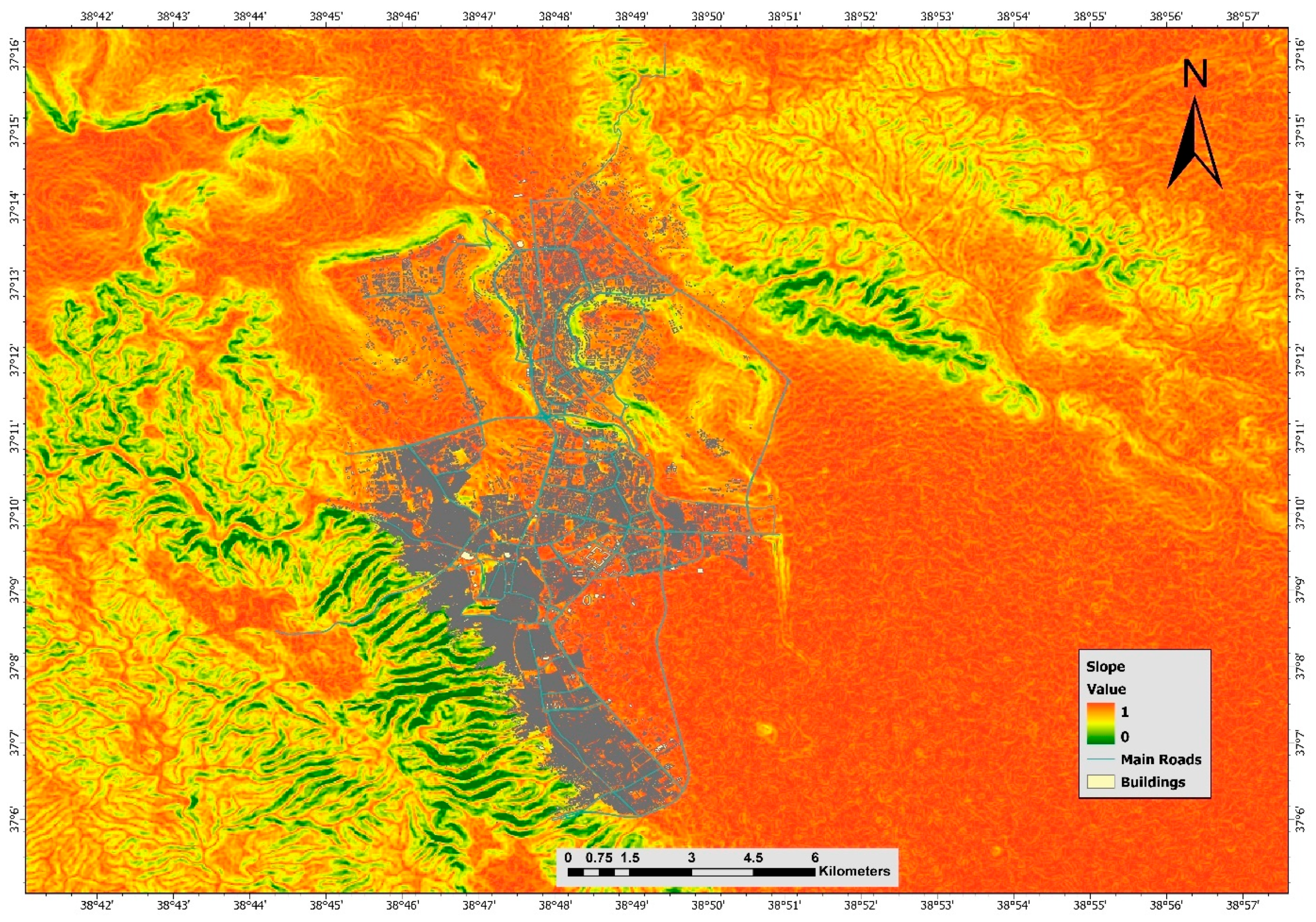
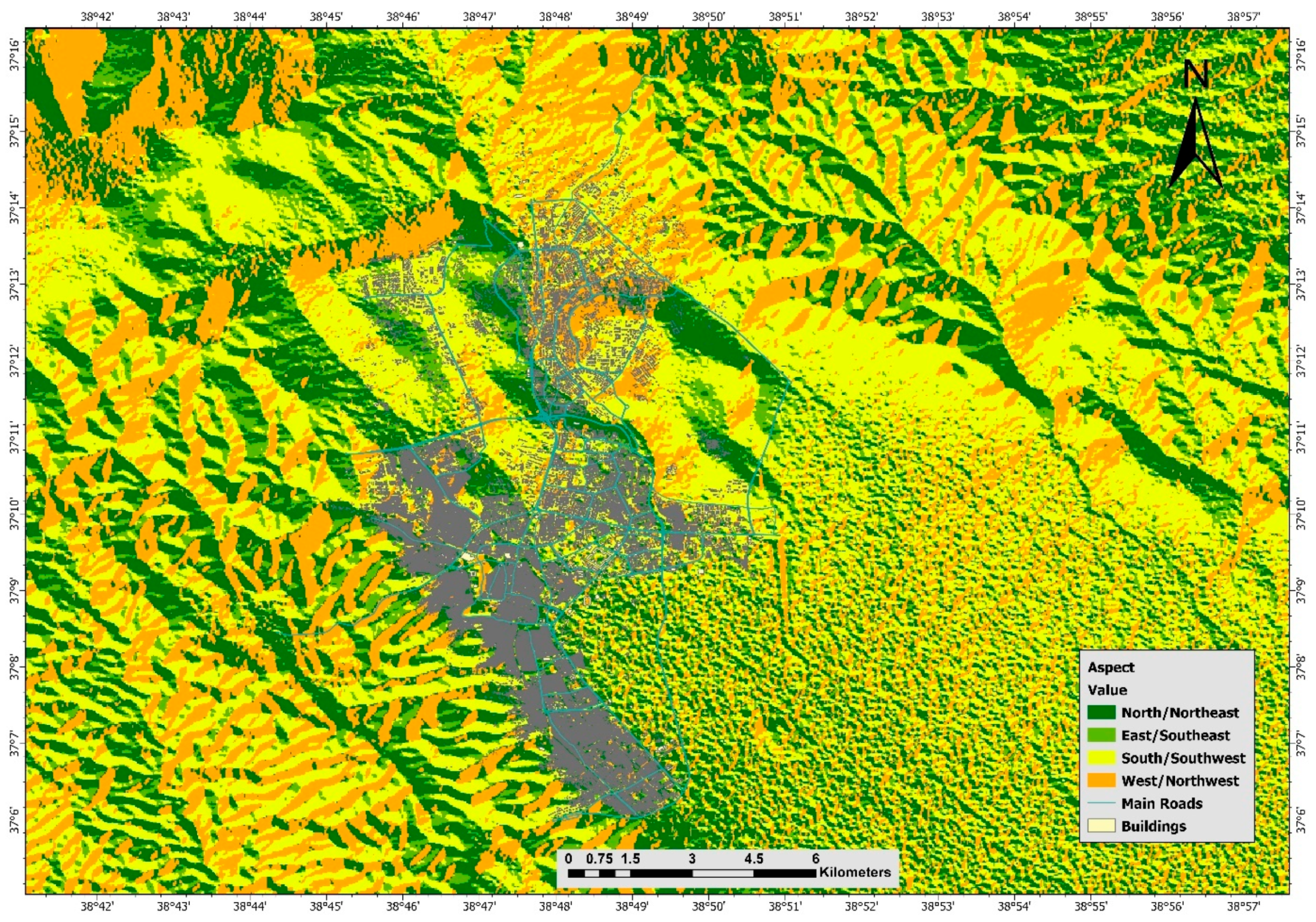

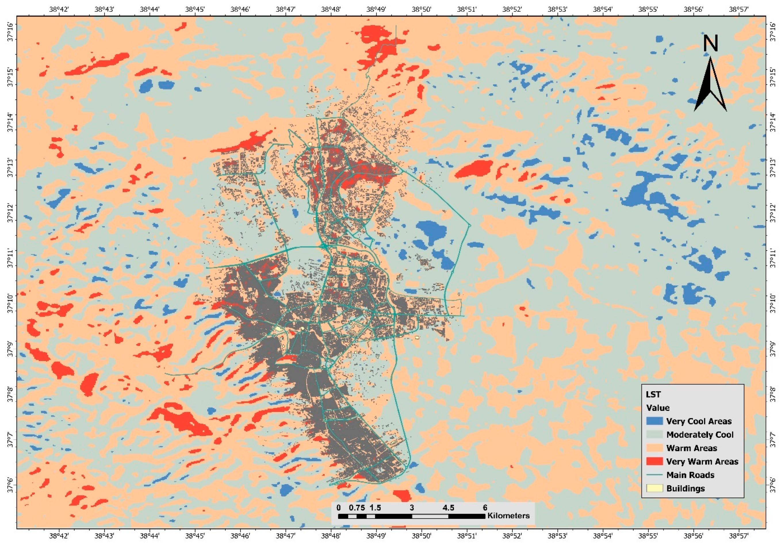
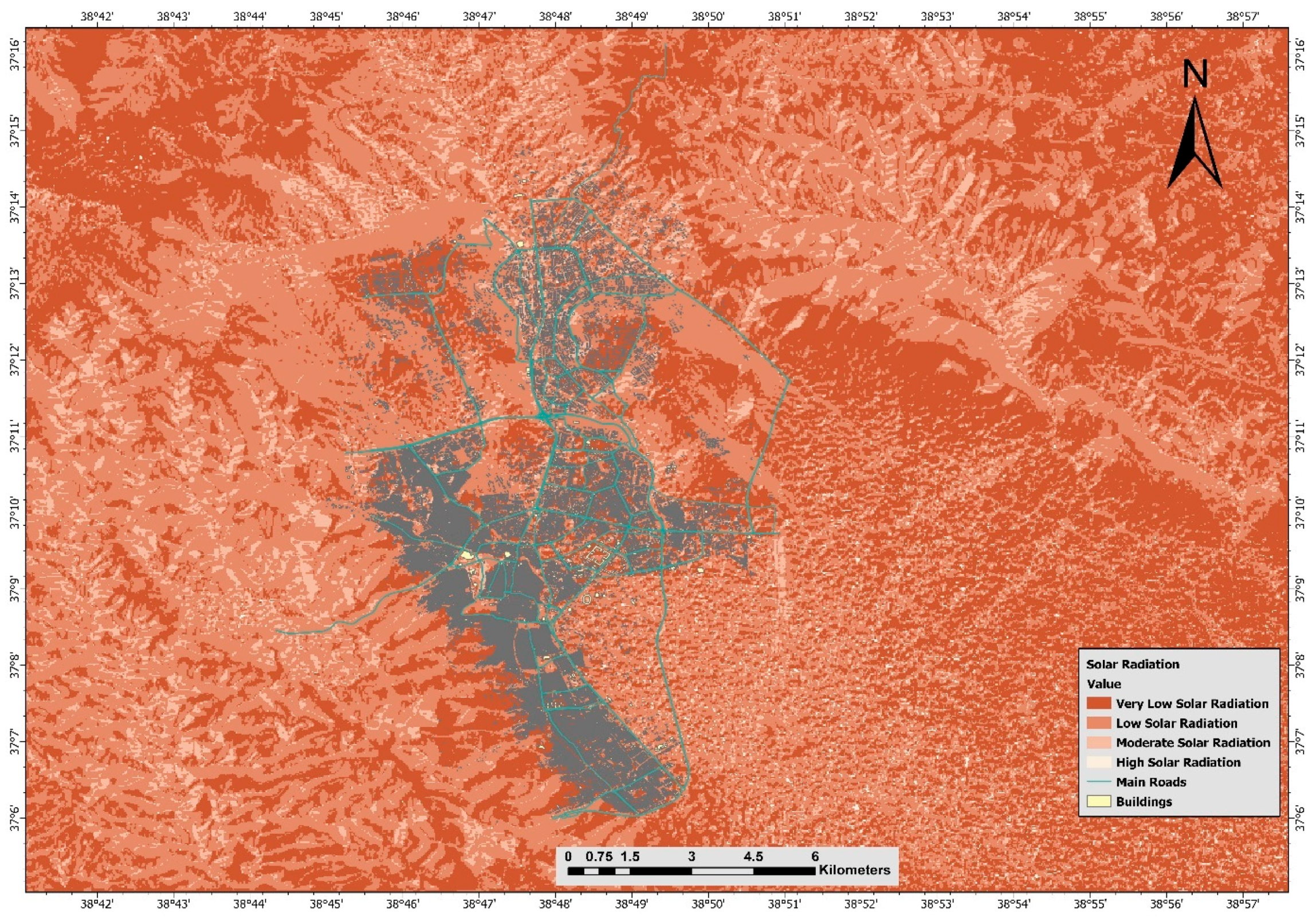

| Criterion | Data Source | Suitability Interpretation |
|---|---|---|
| Slope | SRTM DEM | Lower slopes preferred for planting accessibility |
| Aspect | SRTM DEM | North and east-facing slopes prioritized |
| Elevation | SRTM DEM | Moderate elevations are ecologically favorable |
| LST | Landsat 8 | Cooler areas preferred to reduce urban heat islands |
| Solar Radiation | SRTM DEM | Moderate exposure preferred for growth potential |
| Flow Accumulation | SRTM DEM | Low accumulation preferred to avoid erosion risks |
| Distance to Roads | OpenStreetMap | Moderate proximity facilitates management/logistics |
| Distance to Settlements | OpenStreetMap | Reasonable proximity supports accessibility |
| Land Cover Suitability | Sentinel-2 | Non-forested, non-urban, non-water areas only |
| Criterion | SLO | ASP | ELE | LST | SOL | FLA | DTR | DTS | LCS |
|---|---|---|---|---|---|---|---|---|---|
| Slope | 1 | 2 | 1 | 1/3 | 1 | 3 | 3 | 4 | 2 |
| Aspect | 1 | 1 | 1/5 | 1 | 3 | 2 | 3 | 2 | |
| Elevation | 1 | 1/5 | 1 | 2 | 2 | 2 | 2 | ||
| LST | 1 | 2 | 4 | 4 | 5 | 3 | |||
| Solar Radiation | 1 | 3 | 3 | 3 | 2 | ||||
| Flow Accumulation | 1 | 2 | 3 | 2 | |||||
| Distance to Roads | 1 | 2 | 2 | ||||||
| Distance to Settlements | 1 | 2 | |||||||
| Land Cover Suitability | 1 |
| Criterion | Weight | Weight (%) |
|---|---|---|
| Surface Temperature (LST) | 0.296 | 29.6% |
| Slope | 0.138 | 13.8% |
| Solar Radiation | 0.130 | 13.0% |
| Aspect | 0.106 | 10.6% |
| Elevation | 0.102 | 10.2% |
| Flow Accumulation | 0.072 | 7.2% |
| Distance to Roads | 0.059 | 5.9% |
| Land Cover Suitability | 0.050 | 5.0% |
| Distance to Settlements | 0.046 | 4.6% |
Disclaimer/Publisher’s Note: The statements, opinions and data contained in all publications are solely those of the individual author(s) and contributor(s) and not of MDPI and/or the editor(s). MDPI and/or the editor(s) disclaim responsibility for any injury to people or property resulting from any ideas, methods, instructions or products referred to in the content. |
© 2025 by the authors. Licensee MDPI, Basel, Switzerland. This article is an open access article distributed under the terms and conditions of the Creative Commons Attribution (CC BY) license (https://creativecommons.org/licenses/by/4.0/).
Share and Cite
Şenol, H.İ.; Yiğit, A.Y.; Ulvi, A. GIS-Based Multi-Criteria Analysis for Urban Afforestation Planning in Semi-Arid Cities. Forests 2025, 16, 1064. https://doi.org/10.3390/f16071064
Şenol Hİ, Yiğit AY, Ulvi A. GIS-Based Multi-Criteria Analysis for Urban Afforestation Planning in Semi-Arid Cities. Forests. 2025; 16(7):1064. https://doi.org/10.3390/f16071064
Chicago/Turabian StyleŞenol, Halil İbrahim, Abdurahman Yasin Yiğit, and Ali Ulvi. 2025. "GIS-Based Multi-Criteria Analysis for Urban Afforestation Planning in Semi-Arid Cities" Forests 16, no. 7: 1064. https://doi.org/10.3390/f16071064
APA StyleŞenol, H. İ., Yiğit, A. Y., & Ulvi, A. (2025). GIS-Based Multi-Criteria Analysis for Urban Afforestation Planning in Semi-Arid Cities. Forests, 16(7), 1064. https://doi.org/10.3390/f16071064


