Abstract
Forests are increasingly under pressure due to rapid population growth, unplanned urbanization, and the conversion of forest land for non-forestry uses. In Istanbul, large-scale infrastructure projects—including a major airport, motorways, and a bridge—constructed in forested northern regions have led to significant land use change, generating complex social and environmental impacts. This study examines how local populations perceive the social consequences of these projects. Data were collected through 995 questionnaires across 25 neighborhoods and semi-structured interviews with 18 neighborhood headmen and 5 representatives from NGOs and professional organizations. Exploratory factor analysis was used to categorize perceptions, and Mann–Whitney U tests assessed differences based on proximity to project sites and project type. The findings indicate that both proximity and project type play a key role: residents living closer to the projects—and particularly those living near the airport—report more negative impacts, including feelings of insecurity, increased accident risk, limited employment opportunities, loss of forest, agricultural, and pasture lands, heightened environmental, noise, and air pollution, as well as adverse effects on physical and mental health. Measuring and mitigating these impacts during and after the projects is essential. Properly conducted, audited, and effective social impact assessments are of vital importance for the local people living around the project.
1. Introduction
Land use change, driven primarily by infrastructure expansion and urban growth, represents one of the most profound transformations reshaping the world today. These changes have irreversible consequences for ecosystems, biodiversity, and human communities alike. The majority of these transformations are caused by direct human activities [1], and according to projections, by 2050, human settlements and infrastructure are expected to cover 4%–5% of the global land area as a direct consequence of these pressures [2].
Forests are among the most severely affected ecosystems in this process. In Türkiye, forest land conversion for non-forestry purposes (mining, infrastructure, education facilities, etc.) has intensified over the past decades. As indicated by Atmiş et al. [3], the total area of forest land allocated for such uses has reached 3.5% of the country’s forest territory. The Sustainable Forest Management Türkiye 2019 Report highlights that the increasing number of non-forestry allocations from forest areas has significantly accelerated forest fragmentation. The report further emphasizes that this fragmentation increases the number of discrete forest patches and represents the initial stage of forest land use change. This process not only disrupts ecological continuity but also makes forest ecosystems more vulnerable to conversion and degradation [4]. These transformations have also triggered various forms of community response. As highlighted by Günşen et al. [5], public opposition to forest land allocations in Türkiye has been most prominent in response to mining, energy, and large-scale infrastructure projects, with Istanbul identified as one of the key provinces where such protests have been concentrated.
Istanbul exemplifies these dynamics at the metropolitan scale. As Türkiye’s most densely populated and urbanized province, the city’s northern forest regions have come under increasing pressure from large-scale infrastructure developments, including the Istanbul Airport, the Yavuz Sultan Selim Bridge, and the Northern Marmara Motorway. In addition, the controversial Kanal Istanbul project has been proposed, which would further transform significant areas of forest and water basins in the region. According to official statistics from the General Directorate of Forestry (OGM), forests currently constitute approximately 44% of Istanbul’s total land area [6]. However, this percentage may not accurately reflect on-the-ground changes, as some forest-designated areas have been allocated for non-forestry uses over the years. Şahin [7] states that between 1998 and 2017, a total of 21,358 hectares of forest land in Istanbul was allocated for non-forestry purposes, illustrating the long-term scale of these conversions. A similar trend was observed between 2012 and 2018, as Erdönmez [8] states that 14,000 hectares of forest land was allocated for non-forestry purposes through nearly 800 permits. These figures reflect a wider trend of land use change in Istanbul, where forest allocations for infrastructure projects are closely linked to the city’s expanding urban footprint. Previous research indicates that urban expansion in Istanbul has largely occurred at the expense of forested and agricultural areas. Between 1971 and 2018, settlement areas increased more than fivefold, from 20,813 to 106,087 hectares [9]. Similar transformations have taken place along the city’s coastal regions, where the proportion of built-up areas rose from 36% to 47% between 1987 and 2007, accompanied by parallel declines in forests and farmland [10]. Projections suggest that the construction of the Yavuz Sultan Selim Bridge alone may result in the conversion of over 41,000 hectares of forest into residential zones by 2040 [11]. These transformations not only accelerate ecological degradation but also generate profound socio-cultural and economic consequences for forest-edge communities.
Land use change, particularly the conversion of forest lands, has wide-ranging impacts on the environment, society, and the economy. While industrialization and urbanization have historically driven these changes, their consequences have become increasingly pronounced and detrimental in recent decades [12]. These transformations not only threaten long-term environmental sustainability but also disrupt livelihoods, social structures, and cultural heritage [13,14]. The social impacts of land use change are multidimensional and complex. Planned or unplanned interventions—including infrastructure projects—can lead to changes in lifestyles, cultural practices, political systems, health, welfare, and property rights [13]. Forests, beyond their ecological functions, provide essential services such as clean water, air purification, recreational opportunities, and support for traditional livelihoods and cultural practices. How people perceive and value these services is also shaped by their proximity to forest areas. According to Muhamad et al. [15], living in close proximity to forests enhances people’s awareness and valuation of these ecosystem services, highlighting the importance of local context in shaping perceptions of land use change. The loss of these lands can lead to the disruption of local livelihoods, reduced well-being, and the loss of cultural heritage [14]. These impacts are felt most intensely by communities that depend on resources for their economic, cultural, and social needs. Furthermore, perceptions of these impacts can influence community well-being and responses to change, even when they are not objectively measurable [16].
Research related to large-scale infrastructure projects—such as airports, motorways, and bridges—has largely addressed their economic and environmental impacts. Economic impacts have been widely studied, particularly in relation to local development and employment opportunities [17,18,19,20,21,22]. Environmental consequences, on the other hand, have mainly been associated with air and noise pollution and their implications for public health [23,24,25], as well as impacts on natural resources and wildlife habitats [26,27,28]. Alongside these concerns, a growing number of studies have also examined the social impacts of large-scale infrastructure projects. These studies commonly focus on outcomes such as changes in life satisfaction, social cohesion, perceptions of safety, and livelihood transformations [21,22,28,29].
This study contributes to the international literature on forest land use change by highlighting the experiences of forest-edge populations that are directly exposed to the transformation of forest lands into large-scale infrastructure projects. While much of the existing research has focused on the environmental or economic outcomes of such projects, less attention has been paid to how local residents experience and interpret these changes. By situating the analysis in Istanbul, where infrastructure development has increasingly targeted forested northern districts, this study provides rare empirical evidence on the perceived socio-cultural, economic, environmental, and health-related consequences of forest loss. Specifically, it investigates the following: (1) how local communities perceive the impacts of these projects; (2) whether these perceptions vary by proximity to the project sites; and (3) whether the type of project—such as an airport, a motorway, or a bridge—shapes the nature and intensity of these perceptions. By highlighting the experiences of forest-edge communities, the study offers valuable insight into the often-overlooked social dimensions of forest conversion and supports more inclusive and sustainable planning in forested regions.
2. Materials and Methods
2.1. Study Area
The study was conducted in neighborhoods surrounding large-scale infrastructure projects constructed in forest areas on the northern side of Istanbul. Istanbul is the most metropolitan and urbanized city in Türkiye, where forests are under increasing pressure due to urban expansion. This has made forest–society relations particularly critical. As the city’s population continues to grow, the demand for settlements and infrastructure intensifies, leading to a corresponding increase in non-forestry land allocations.
The three major infrastructure projects—the Istanbul Airport, the Yavuz Sultan Selim Bridge, and the Northern Marmara Motorway—are located in the northern part of the city, where forest cover is densest. The Istanbul Airport occupies an area of 7650 hectares, 5230 hectares of which was formerly forest land [30]. Similarly, the Northern Marmara Motorway and Yavuz Sultan Selim Bridge were constructed over an area totaling 3374 hectares, of which 2673 hectares was forested [31]. The development of these projects has resulted in significant land use change and has generated substantial social impacts in the region.
In this context, 25 neighborhoods were identified within the districts of Sarıyer, Arnavutköy, and Eyüpsultan, located within the surrounding areas of the projects and along their routes. These neighborhoods were selected as the study sample based on spatial proximity and land use characteristics. Field interviews with local headmen (mukhtars) further confirmed their suitability, as these communities have experienced marked impacts from land use transformation.
Proximity was defined not solely based on Euclidean distance but also by spatial and contextual adjacency. Neighborhoods directly bordering the project area were categorized as being in close proximity (near), while those located just beyond this first ring—yet still relatively near—were considered distant. This classification better reflects actual exposure to project-related disruptions and aligns with observable differences in infrastructure, traffic flow, and environmental change. Figure 1 shows the map of the study area.
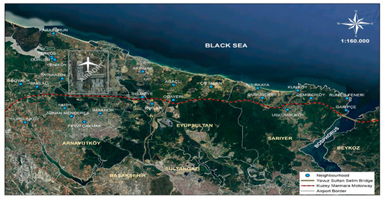
Figure 1.
Study area (prepared with ArcMap 10.5).
The residents of these neighborhoods—many of which were previously designated as villages or forest villages before the implementation of Law No. 6360 in 2012—continue to lead predominantly rural lifestyles compared to those in central Istanbul. Consequently, they are more vulnerable to the rapid transformation brought about by large-scale infrastructure development.
2.2. Method
Following the identification of the study area, field-based reports were reviewed, on-site observations were carried out in the designated neighborhoods during the construction phase of the projects, and preliminary interviews were conducted with local residents. Based on the insights gained from this initial stage, a structured questionnaire and a semi-structured interview guide were developed.
The questionnaire was first tested through a pilot survey conducted with 100 residents across 4 neighborhoods, which were selected based on their proximity to the project sites. Within each neighborhood, participants were selected using random sampling to reduce selection bias and to ensure that a range of household perspectives were captured. Based on the findings from the pilot study, several modifications were made to the questionnaire: complex or ambiguous items were revised for clarity, redundant questions were removed, and response categories were refined to improve interpretability and response accuracy.
After pilot study corrections, full-scale fieldwork was carried out. A total of 995 questionnaires were administered across 25 neighborhoods, and semi-structured interviews were conducted with 18 neighborhood headmen (mukhtars) and 5 representatives from non-governmental organizations (NGOs).
The 25 neighborhoods were selected using purposive sampling based on their geographical location along the project corridors. All selected neighborhoods are situated in close proximity (i.e., either directly bordering the project areas—classified as “near”, adjacent to those neighborhoods—classified as “distant”) to the Istanbul Airport, the Northern Marmara Motorway, and the Yavuz Sultan Selim Bridge, ensuring that the sample included communities within the spatial impact zone of the projects. Within each neighborhood, questionnaire respondents were selected randomly to ensure variation in household-level perspectives. These neighborhoods are predominantly rural or peri-urban in character, providing a consistent yet diverse context for examining the social effects of land use change.
The questionnaire consisted of 2 sections and a total of 47 statements. The first section included 35 Likert-scale items designed to measure respondents’ perceptions across 4 thematic areas: socio-cultural change, economic impacts, environmental and health-related concerns, and future evaluations. These items were rated on a five-point Likert scale ranging from 1 (“strongly disagree”) to 5 (“strongly agree”). The second section comprised 12 questions aimed at collecting background information on the participants. This section included a combination of ordinal, categorical, and open-ended questions covering demographics such as age, gender, education level, income, and occupation. The questionnaire was administered through face-to-face interviews. Informed consent was obtained verbally after participants were informed about the aim of the study, their voluntary participation, and their right to withdraw at any point. A total of 1025 questionnaires were completed during fieldwork, of which 995 were found to be valid and included in the final analysis. A demographic profile of the participants is presented in Appendix A.1. The high response and completion rate indicates strong participant engagement and interest in the research topic.
Semi-structured interviews were conducted with 18 neighborhood headmen (mukhtars) and 5 representatives from non-governmental organizations (NGOs). Interviews with headmen were carried out in 18 of the 25 neighborhoods included in the study, corresponding to 72% of the total. The remaining headmen either declined the invitation to participate or were unavailable at the time of fieldwork. This high participation rate enhances the depth and credibility of the qualitative findings. NGO representatives were selected based on their expertise and direct involvement in monitoring or reporting on the infrastructure projects. The interview process continued until thematic saturation was reached—no new insights emerged during the final rounds—indicating that the sample size was sufficient for capturing the diversity of perspectives relevant to the study’s objectives.
Upon the completion of data collection, reliability analysis was conducted to assess the internal consistency of the questionnaire. An exploratory factor analysis (EFA) was then applied to identify the underlying structure of the items. Additionally, frequency distributions of the participant responses were analyzed.
To determine whether there were statistically significant differences in perceived impacts based on spatial and categorical variables, the Mann–Whitney U test was employed in two comparisons: (i) between neighborhoods classified as near and distant to the projects (proximity), and (ii) between neighborhoods located around the airport and those around the motorway and bridge (project type). An overview of the study workflow is presented in Figure 2.
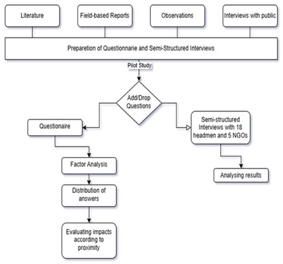
Figure 2.
Workflow of the study.
A reliability analysis was conducted to evaluate the internal consistency of the scale. According to Hair et al. [32], a Cronbach’s alpha value above 0.70 is considered acceptable, and above 0.80 is considered good. The calculated Cronbach’s alpha values for each dimension were as follows: socio-cultural impacts (α = 0.79), economic impacts (α = 0.68), environmental and health-related impacts (α = 0.88), and future evaluations (α = 0.73). As shown in Appendix A.2 the economic dimension had the lowest reliability coefficient, although it remains close to the 0.70 threshold. The environmental dimension had the highest internal consistency, followed by socio-cultural and future evaluation dimensions. These results indicate that the scale demonstrates acceptable reliability overall.
Exploratory factor analysis (EFA) was conducted to reduce the number of variables, examine dimensionality, and group items into meaningful factors. The primary objective of factor analysis is to determine the number, nature, and structure of the underlying factors [33]. The Kaiser–Meyer–Olkin (KMO) and Bartlett’s Test of Sphericity were used to assess the suitability of the dataset. KMO values were found to be 0.83 for socio-cultural impacts, 0.78 for economic impacts, 0.91 for environmental and health-related impacts, and 0.75 for future evaluations—all exceeding the 0.50 minimum threshold. Bartlett’s Test of Sphericity was statistically significant (p < 0.01) for all factor groups, indicating strong correlations among items and confirming the dataset’s suitability for factor analysis.
Appendix A.2 presents the factor loadings for each dimension, alongside the respective Cronbach’s alpha scores, KMO values, and Bartlett’s test results. In the next step, new index variables were created for each factor by selecting items with factor loadings above 0.50.
The factor analysis identified four thematic dimensions reflecting the perceived impacts of projects, as follows:
- Socio-cultural impacts (12 items): Items with the highest loadings related to traditions and culture, the distinctive characteristics of the region, family structure and relationships, and sense of belonging. Other components included neighborhood safety, social spaces, desire to continue living in the area, and everyday life impacts. One item—“I think the place where I live is now more peaceful”—had a negative loading (−0.498) due to reverse coding.
- Economic impacts (6 items): The highest loading items concerned perceptions of project contributions to the local economy. Other items addressed economic benefits to locals, welfare, ease of earning income, employment opportunities, and national economic contributions.
- Environmental and health-related impacts (12 items): This factor included concerns regarding migratory bird patterns, air and environmental pollution, degradation of natural resources, water scarcity, climate change, and overall environmental deterioration. Other items related to damage to agricultural and pasture lands, loss of green and forested areas, and effects on physical and mental health.
- Future evaluations (5 items): Items with high factor loadings involved expectations about increased public and private sector services. Other indicators included increases in socio-cultural activities, regional attractiveness, and urban development.
Based on these factor groupings, Mann–Whitney U tests were conducted separately for each dimension to evaluate whether statistically significant differences existed in perceptions according to project proximity (near vs. distant neighborhoods) and project type (airport vs. motorway and bridge). The Mann–Whitney U test is a non-parametric test used to compare differences between two independent groups when data are not normally distributed.
In addition to the quantitative analysis, semi-structured interviews were conducted with 18 neighborhood headmen (mukhtars), as well as five representatives from NGOs and professional organizations. A short questionnaire with four core questions was developed for the interviews, focusing on: (i) perceptions of forest land conversion for project construction, (ii) the effects of land use change on local communities, and (iii) perceived social, economic, environmental, and health-related consequences at both local and national levels. Additional questions were asked when needed. Recurring themes and shared responses were summarized, and frequency counts (ƒ) were presented to indicate the prevalence of opinions.
3. Results
This section presents the findings related to participants’ evaluations of the perceived impacts of large-scale infrastructure projects implemented in the region. The analysis focuses on four key dimensions, as follows: socio-cultural impacts, economic impacts, environmental and health-related impacts, and future evaluations.
3.1. Socio-Cultural Impacts
The findings suggest that the highest level of perceived negative socio-cultural impact was associated with a loss of peacefulness in the region, with 56.2% of participants expressing disagreement with the statement “the place is now more peaceful”. This was followed by perceptions of an increased risk of accidents (52.1%), feelings of unsafety (49.0%), and difficulty adapting to change (47.1%).
In contrast, some aspects of community life were perceived to be less negatively impacted. Only 12.5% of participants stated that they no longer wanted to live in the neighborhood, and 13.7% reported a reduced sense of belonging. Similarly, negative perceptions of family structure being affected (16.8%) and weakened neighborhood relations (20.5%) were relatively low.
Cultural aspects such as the perceived decline of regional identity (39.0%), the deterioration of local culture and traditions (32.3%), the negative effects on daily life (27.5%), and the erosion of communal social spaces (17.6%) also raised concern, although to a lesser degree than safety-related issues. The most significant impacts appeared to be linked to safety, adaptation, and cultural identity.
These findings reflect that although respondents reported substantial changes in the emotional and cultural landscape of their neighborhoods, more personal or community-based social bonds—such as family, neighborhood connection, and belonging—appeared less affected. A detailed response distribution is presented in Figure 3.
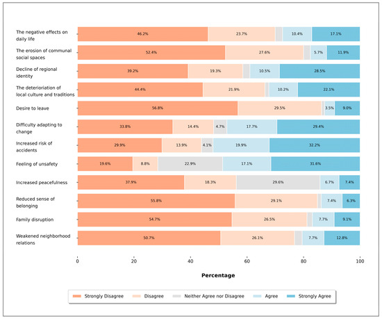
Figure 3.
Distribution of local people’s perceptions regarding socio-cultural impacts.
The Mann–Whitney U test results indicate that both proximity to the project and project type significantly influenced a wide range of socio-cultural perceptions (Table 1). Respondents living near the projects, and those residing in the airport area in particular, reported significantly more negative perceptions regarding peacefulness, feeling of unsafety, and difficulty adapting to change.

Table 1.
Mann–Whitney U test results on socio-cultural impacts of the projects.
Although other aspects of community and family life and cultural identity received relatively fewer negative perceptions overall, the most negative evaluations within those aspects also came from participants closer to the projects and residing in the airport area. This indicates that even when dissatisfaction is less widespread, proximity and the scale of land use change—particularly in the case of the airport—correspond with sharper perceptions of socio-cultural disruption.
Conclusions that emerged during the interviews with headmen are as follows:
- Since most neighborhoods do not have zoning permits, population growth has not been observed, but there is concern that this will change in the future and these areas will be built up more (f = 6);
- The way of life of local people (intertwined with nature, engaged in animal husbandry and agriculture) will change (f = 4);
- Neighborhood relations will be affected in the future (f = 4);
- Risk of accidents has increased (f = 3).
The impacts that have been identified here are generally related to the concerns of local residents about the future. While the idea that the region will develop over time leads to a perception that better infrastructure services will be available, the fact that lifestyles have changed and will continue to change raises concerns in terms of adapting to the new conditions. In addition, it is also predicted that neighborhood relations will be negatively affected by the changes resulting from these new conditions. The positive contribution of the projects to the region has been the ease of transportation; however, the intensive operation of excavation trucks in the area and the increase in traffic compared to the previous situation have increased the risk of accidents.
3.2. Economic Impacts
The findings reveal that participants predominantly held negative perceptions regarding the local economic outcomes of the projects. The highest levels of dissatisfaction were observed in terms of income distribution and financial ease. Specifically, 80.6% of respondents disagreed or strongly disagreed with the statement that a large part of the local people benefits from the income generated by the projects, and 80.1% stated that earning enough money to live on has not become easier. Similarly, 72.0% perceived no improvement in employment opportunities, and 59.7% felt that their individual welfare levels had not increased.
In addition, 55.4% of participants did not believe that the projects contributed positively to the local economy. However, in contrast, only 30.1% expressed doubt regarding the projects’ contribution to the national economy, with 39.4% strongly agreeing that such investments would significantly enhance the country’s economic development. This divergence highlights a core issue in large-scale infrastructure planning; while projects may be viewed as beneficial at the macroeconomic level, they often fall short in delivering localized economic improvements, particularly in employment and income equity. A detailed response distribution is presented in Figure 4.
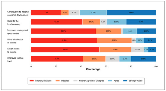
Figure 4.
Distribution of local people’s perceptions regarding economic impacts.
The Mann–Whitney U test results revealed statistically significant differences in the perceptions of only two economic impact items based on proximity and project type (Table 2). Respondents living farther from the projects evaluated the statement “boost to the local economy” more positively than those living nearby (p < 0.005), suggesting that those directly affected by the projects perceive fewer local economic benefits. In contrast, participants living near the airport reported more positive views on improved employment opportunities than those near the motorway or bridge (p < 0.002).
Table 2.
Mann–Whitney U test results on economic impacts of the projects.
Although most of the remaining items did not differ significantly across groups, the overall pattern of responses indicates a generally negative perception of economic benefits, with the notable exception of the item on national economic development, which received relatively higher scores across all groups.
Major conclusions that were highlighted in interviews with headmen are as follows:
- Income from forestry, agriculture, and animal husbandry has decreased (f = 6);
- Projects have increased the land values (f = 5);
- The roads divided the pastures, and cattle crossing the pastures were hit by vehicles, resulting in financial losses (f = 4);
- Agriculture and milk yields decreased due to dust during the construction phase of the projects (f = 3);
- Local people who did not own property were negatively affected by rent increases (f = 3);
- Employment opportunities have increased (f = 2), but the impact on employment has had a minimal or no impact (f = 3);
- Income from fishing has decreased (f = 2).
The major impact of the projects is said to be the increase in the value of land in the region (this assessment was made before the issue of rent increases in Istanbul). However, there have also been rent increases in the region. This has two main consequences; while those who own more than one house can earn extra income by renting out their properties (a positive effect), those who live and work in rented accommodations (houses and workplaces) are negatively affected by these increases and are considering leaving the region. In neighborhoods close to the airport that are indirectly affected by the airport (e.g., mining and excavations), livestock farming is mostly negatively affected. Due to the construction of the airport on the pastures of these neighborhoods and the highway dividing some pastures, pasture areas have decreased, and various animal accidents have occurred. Both agriculture and animal husbandry have suffered income losses. Revenues from forests have decreased over the years, and forestry activities in several neighborhoods have completely ceased with the projects.
The productivity of agricultural areas has decreased due to the high amount of dust, especially during the construction of the projects. In neighborhoods where the negative impacts are more prevalent, there are limited employment opportunities due to the airport; conversely, in neighborhoods with lower levels of negative impacts and more positive impacts, the airport employs more workers.
It was also remarked that the number of people working in animal husbandry and the number of animals have decreased after the projects, as the pastures are now divided by roads and animals no longer have access to pasture areas, which leads to various accidents and material losses. It was also recognized that many animals perished due to quarries (the mines in question having been opened for the airport), which have also decreased pasture areas.
In some neighborhoods, it was stated that the entrances to the sea were closed due to the discharge of excavation into the sea, which both polluted the water and led to a decrease in the number of visitors coming to the region, which in turn led to a decrease in income.
3.3. Environment and Health-Related Impacts
The findings reveal widespread perceptions of environmental and health-related deterioration associated with large-scale infrastructure projects. The strongest concern was about the reduction in forest areas, with 88.4% of respondents agreeing or strongly agreeing that these areas have been severely damaged. This was closely followed by the perceived loss of agricultural and pasture lands (85.9%) and increased environmental pollution and damage to natural resources (78.0%).
In addition, 75.5% of respondents anticipated that environmental problems will continue to increase, and 73.6% believed that water resources and drinking water supplies have been negatively affected. A similar proportion (73.4%) stated that the arrival and living conditions of migratory birds have declined. Visual quality also emerged as a concern, with 72.1% indicating that the decrease in green areas has reduced the aesthetic value of the region.
Pollution-related impacts were also strongly perceived: 67.3% of participants believed that air pollution has increased, while 66.4% observed increased noise pollution. Similarly, 66.9% agreed that climatic conditions in the region have changed.
In terms of health impacts, 60.9% of participants felt that their physical and/or psychological health had been negatively affected, and 50.9% believed that general health problems in the area had increased. Notably, the median response for most environmental items was 5, indicating strong agreement, whereas the median for both health-related items was 2, reflecting clear concern and disagreement with the idea that health conditions remained unaffected. A detailed response distribution is presented in Figure 5.
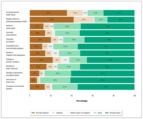
Figure 5.
Distribution of local people’s perceptions regarding environmental and health-related impacts.
The Mann–Whitney U test results demonstrate that participants’ perceptions of environmental and health-related impacts were predominantly negative, with statistically significant differences observed based on both proximity and project type (Table 3). The results reflect widespread concern regarding environmental degradation and health risks, particularly among those living near the projects and those residing in the airport area, where perceived impacts were notably more severe.
Table 3.
Mann-Whitney U test results on environmental and health-related impacts of the projects.
The following issues were highlighted in the interviews with headmen:
- Forest areas have been reduced and damaged (f = 11);
- Air pollution (from dust, soil) has increased (f = 7);
- The projects and related stone mines have damaged or destroyed wetlands (ponds) and drinking water (f = 6);
- Pasture areas have been reduced, divided, and damaged (f = 5);
- Climatic conditions in the region have been affected (decreased precipitation, increased wind, etc.) (f = 5);
- The arrival of migratory birds to the region has decreased (f = 5);
- Excavations disposed into the sea contaminate the sea (f = 4);
- Noise pollution (from airports, roads, mines) has increased (f = 4);
- Agricultural areas have decreased (f = 3).
In general, neighborhoods close to the projects stated that a lot of forest areas have been destroyed, although one headman remarked that the area is a heathland and mining area, so forest areas have not been damaged. Overall, it was emphasized that pasture and agricultural areas have also decreased.
It was stated that there was a lot of noise, dust, and air pollution in the neighborhoods close to the projects (especially the airport). After the airport became operational, a few neighborhoods (specifically those along flight routes) were negatively affected by noise. Neighborhoods with an elderly population were found to be particularly sensitive.
It was emphasized that the projects (especially the airport) resulted in the filling of many ponds which were used by buffaloes, birds, and other animals, as well as by people for fishing. It was also mentioned that the sea was being polluted by the dumping of excavated dirt and substrate thought to originate from these projects.
It was stated that with the decrease in forests, there would be a corresponding decrease in precipitation and an increase in wind. It was mentioned that the arrival of migratory birds to the region has decreased, and wild animals have also been affected. Some neighborhoods (especially those close to the project) emphasized that recreational areas have also decreased due to the decrease in forest area.
3.4. Future Evaluations
The results indicate that participants generally hold optimistic expectations regarding the future impacts of the infrastructure projects. The most frequently expressed expectation was that urbanization in the region will accelerate, with 75.4% of respondents agreeing or strongly agreeing with this statement. This was followed by similarly strong beliefs that the region will become more attractive and preferable to live in (72.2%) and that private sector services will expand (72.6%).
A moderate level of agreement was observed regarding the expected increase in public services (60.3%) and socio-cultural activities (55.2%). Nevertheless, for these two items, around one-third of respondents still expressed disagreement (32.5% and 33.9%, respectively), suggesting that optimism is not uniformly shared across all aspects of community development.
Overall, these results reflect a forward-looking optimism, particularly in terms of regional growth, investment, and service expansion. However, they also highlight potential uncertainty or skepticism about the broader socio-cultural transformation that might accompany these developments. A detailed response distribution is presented in Figure 6.
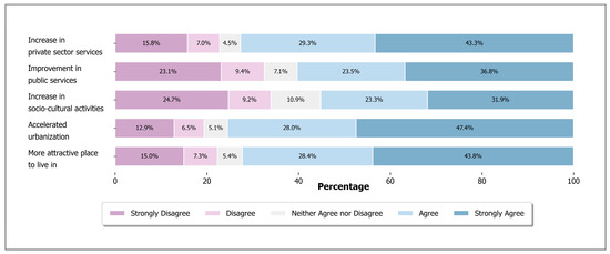
Figure 6.
Distribution of local people’s future evaluations.
The Mann–Whitney U test results revealed significant differences in how participants evaluated the future prospects of their neighborhoods, based on both proximity to the project and, to a lesser extent, project type (Table 4). Participants living farther from the projects consistently gave more positive ratings across all items, including perceptions of urbanization, socio-cultural vitality, and improvements in public and private services.
Table 4.
Mann–Whitney U test results on future evaluations of local people.
Regarding project type, the statement “more attractive place to live in” was evaluated less positively by those living near the airport, compared to those near the motorway or bridge (p < 0.037). This suggests that closer proximity—especially to large-scale projects like the airport—correlates with a less favorable assessment.
In the interviews with NGOs, the following issues were emphasized:
- Most NGOs interviewed were concerned that Istanbul is a city that has grown along the east–west axis, but that projects in the north will expand the city towards a region where natural areas are also located (f = 3); one, however, stated that the city will not grow towards the north as forest areas cannot be used for development (f = 1). Another stated that the city has already started to grow towards the north (based on the examples of Zekeriyaköy and Uskumruköy) and that this growth will continue even without the projects, which will not affect growth (f = 1).
- The region will develop gradually (concerning infrastructure, transportation, job opportunities, and social opportunities) (f = 3).
The impacts that have emerged are generally related to the concerns of local residents about the future. While the idea that the region will develop over time leads to a perception that better infrastructure services will be available, the fact that lifestyles have changed and will continue to change raises concerns about adapting to new conditions.
4. Discussion
4.1. Socio-Cultural Impacts
This study demonstrates that the predominant perception among local residents is that the region has become more disturbed and less safe following the implementation of large-scale infrastructure projects. Feelings of unease and insecurity were particularly pronounced among residents living in closer proximity to project areas, and interviews with neighborhood headmen confirmed a perceived increase in the incidence of traffic accidents. These findings are consistent with previous research by Geurs et al. [29], who identified risk of accidents and concerns about safety as key social impacts associated with transportation infrastructure. Similarly, Moterrubio et al. [28] found that increased heavy vehicle traffic due to airport development contributed to more frequent accidents and was associated with heightened perceptions of crime risk.
Safety concerns appear to be part of a broader sense of disruption. Perceptions of traffic volume and personal safety—particularly in relation to increased vehicle flow and the perceived dangers of navigating public spaces—were among the most commonly reported issues in [21], with proximity to the motorway playing a key role in shaping these concerns. Their study also highlighted that perceptions of infrastructure impacts were influenced by factors such as length of residence, neighborhood attachment, and the spatial distribution of social networks—all of which were relevant in the present study and may help explain the heightened concerns among residents living closer to project sites. Similar patterns were identified in airport-related developments. Piotrowska-Trybull et al. [22] found that satisfaction with living near an airport varied significantly by distance; individuals residing farther away reported greater satisfaction and improvements in quality of life compared to those living nearby, who attributed their dissatisfaction largely to aircraft noise and increased car traffic. These findings reinforce the central role of proximity in shaping residents’ perceptions of peace and safety, as also observed in the present study.
While concerns related to peace, adaptation, and cultural identity were widespread, more intimate aspects of social life such as family cohesion, neighborhood relations, and sense of belonging were comparatively less affected. These findings are consistent with the observation that population growth in most neighborhoods has been limited due to the lack of comprehensive zoning permits, which has slowed the pace of large-scale in-migration. Interview data confirmed that headmen were aware of this dynamic and noted that while future demographic pressures are likely, most neighborhoods have not yet experienced significant population increases. TURKSTAT [34] data support this, showing that between 2013 and 2021, only a small number of neighborhoods experienced growth, while the majority saw slight population declines. Williams and Schirmer [35] emphasize that even small demographic changes in rural communities can significantly impact social structures and community cohesion.
Nevertheless, some socio-cultural impacts are already emerging in subtle forms. For example, the migration of families who were traditionally engaged in agriculture and animal husbandry has begun to reshape the demographic and occupational character of affected areas. The headmen and NGO representatives interviewed in this study emphasized that the disruption of these livelihoods is a significant factor contributing to local displacement. Although the Airport ESIA report assessed these demographic shifts as having a low impact, the Bridge and Motorway ESIA reports anticipated an increase in the male population in certain areas, which may lead to adverse socio-cultural outcomes over time.
Concerns about weakening neighborhood cohesion, personal privacy, and quality of life were also noted, reflecting similar concerns as those reported by Varlıer and Özçevik [36], who found that residents affected by the Yavuz Sultan Selim Bridge project feared that large-scale transformations could threaten long-standing social ties. These fears are not unfounded; interviews in the present study revealed isolated tensions between local residents and incoming laborers during the construction phase. The Airport ESIA report itself acknowledged the potential for social conflict due to labor influx during both the construction and operational periods [30].
These observations reinforce the importance of assessing socio-cultural impacts not only as secondary outcomes but as central considerations in the planning and evaluation of major infrastructure developments. While the improvement of physical connectivity is often emphasized, the erosion of social cohesion, disruption of place-based identities, and deterioration in perceived safety are equally impactful—albeit less visible—dimensions of such projects. Future research should focus on long-term, community-based monitoring to better understand the evolving social fabric in affected areas. These insights can inform more holistic policy responses that protect social integrity and minimize the unintended consequences of development.
The findings suggest a need to rethink how social impact assessments (SIAs) are designed and implemented in infrastructure planning. SIAs should not be treated as one-time formalities conducted before project approval, but instead as continuous processes that begin in early planning and extend into post-completion phases. They must be participatory, adaptive, and attentive to localized and evolving impacts over time. Particularly in large-scale infrastructure projects, sustained SIA mechanisms can help address uneven and long-term socio-cultural consequences.
4.2. Economic Impacts
Airports are frequently regarded as catalysts for regional economic development, generating direct, indirect, and induced effects [37,38,39]. Numerous studies have supported this perspective, demonstrating positive relationships between airports and regional economic growth. For instance, Florida et al. [40] identified a strong association between airports and regional economic development, particularly in areas served by large airports. Similarly, Percoco [17] found that increases in air passenger traffic significantly boost employment in the service sector, with positive spillover effects into adjacent regions. Blonigen and Cristea [18] further linked growing air traffic to regional population and income growth, as well as the expansion of service and retail sectors. However, contrasting findings also exist. For example, [20] found no significant correlation between hub airport activity and reduced unemployment rates in nearby communities; instead, he observed a rise in unemployment levels in some areas.
While proximity to major road networks is often associated with increased employment densities and the expansion of urban functions such as commercial and industrial development [19], local perceptions may not always align with these broader economic expectations. As Ogilvie et al. [21] note, while key informants frequently emphasized the economic development potential of new motorway infrastructure, residents more often focused on immediate practical benefits such as reduced travel time, and some even speculated that any economic gains would primarily benefit those outside their communities.
Consistent with these conflicting findings in the literature, the study presents a more complex and localized perspective. The majority of local residents perceive that the infrastructure projects, particularly the airport, have not resulted in increased employment opportunities or improvements in welfare levels. Many respondents believe that earning a livelihood has not become easier, and there is a widespread perception that the income generated by these projects has not been fairly distributed among local communities. Furthermore, the projects are generally viewed as contributing more significantly to the national economy rather than delivering tangible economic benefits to the local population.
Participants stated that the airport not only increased their own employment opportunities, but also served as a business attraction for new investors and supported the development of local businesses [22].
Proximity to the projects appears to influence these perceptions. Residents living closer to the airport report a slight increase in employment opportunities compared to those near the bridge and highway projects. Conversely, individuals residing farther from the developments tend to believe that the projects have contributed more significantly to the local economy. Although these trends were not highly prominent in the quantitative survey data, insights gathered from semi-structured interviews with community leaders offer additional context. Specifically, two neighborhood headmen stated that employment opportunities had increased, particularly due to the airport project, which provided jobs during and after the construction phase. In contrast, three headmen reported that the projects contributed little or not at all to local employment. These findings suggest that while some neighborhoods have benefited from job creation, others have experienced minimal or no gains in employment opportunities. NGOs and professional organizations consulted during the study also emphasized the loss of income experienced by local communities and raised concerns about the uneven distribution of economic benefits.
Furthermore, while the Airport ESIA report highlights regional economic growth and increased job opportunities as major positive impacts of the projects, it remains uncertain whether this projected growth will translate into meaningful and sustainable benefits for local communities. Although the ESIA acknowledges the irreversible loss of agricultural and pasture lands as a long-term high-significance impact, it argues that fair compensation payments could mitigate these negative effects [41]. However, our findings suggest that for households dependent on agriculture, animal husbandry, and forestry, the loss of land is not solely an economic issue; it also undermines livelihoods and could lead to broader social consequences, including increased migration and a cascade of additional socio-economic challenges that warrant further investigation.
4.3. Environmental and Health-Related Impacts
The perceptions of local people regarding the environmental and health-related impacts of the airport and related infrastructure projects are notably strong and predominantly negative. In particular, those living in close proximity to the airport and other large-scale projects reported more significant adverse effects. This perception is consistently supported by both quantitative survey data and qualitative interviews with community representatives, professional organizations, and NGOs. Among the key issues identified were reductions in forest, agricultural, and pasture areas, which are seen as contributing to ecosystem fragmentation and deterioration. These findings align with those of [42], who highlighted that large infrastructure projects lead to forest fragmentation and negatively affect forest ecosystem services. Similarly, Atmiş et al. [3] emphasized the location of such projects in significant forested areas, contributing to deforestation.
Additionally, NGOs pointed out disruptions to ecosystem integrity, particularly the damage to flora and fauna. These findings are in line with earlier studies such as [26], which reported the fragmentation of habitats, increased animal mortality due to road traffic, and damage to wetland ecosystems. Mansuroglu et al. [27] further identified that motorway construction disrupts water systems, exacerbating environmental degradation. Our findings similarly indicate that water resources in the region have been negatively affected.
There is also a strong perception among local residents that the regional climate has changed, with reports of reduced precipitation and increased wind, as indicated by both survey results and interviews. This perception is supported by Sekamane et al. [43], who reported that communities living near large infrastructure developments often associate these projects with localized climate changes.
The Istanbul Airport’s location on a critical migratory bird route further exacerbates environmental concerns. Studies conducted prior to the airport’s construction, such as Arslangündoğdu [44], highlighted potential negative impacts on migratory bird populations. Our findings confirm that the number of migratory birds arriving in the region has decreased, which aligns with the concerns expressed by Monterrubio et al. [28] regarding the detrimental impacts of airport construction on avian fauna and flora.
Concerns about deteriorating air and noise quality emerged as one of the most prominent themes in participants’ responses. A majority of participants expressed concern over pollution-related disturbances, with over two-thirds perceiving a rise in both air and noise pollution in their surroundings. Although no significant differences were observed across project types, proximity emerged as a key factor; those living closer to the infrastructure consistently reported more intense experiences of both air and noise pollution. These findings align with previous research highlighting the role of spatial proximity in shaping pollution-related perceptions. Ogilvie et al. [21] similarly reported that perceptions of air and noise pollution were closely tied to residential proximity to motorway infrastructure. Moreover, Piotrowska-Trybull et al. [22] found that noise was more disturbing in areas near airports, and that perceptions of declining air quality were common regardless of distance. Przespolewska-Gdowik and Jasinski [25] highlighted that individuals living near airports and within prevailing wind directions are more heavily exposed to air pollutants, a pattern reflected in our data. Lefevre et al. [45] also observed that individuals annoyed by aircraft noise tend to report lower perceived quality of life, consistent with sentiments expressed by our respondents. Maurice et al. [23] identified associations between air pollution and physical health problems, as well as between noise pollution and both physical illnesses and longer-term mental health conditions—relationships that resonate with the concerns raised in our study. Johnson et al. [24] identified similar risks in their study of communities near airports, emphasizing the multiple health risks posed by air and noise pollution.
Our fieldwork findings further support and contextualize these observations. According to both the questionnaire results and interviews with local headmen, increases in noise and air pollution—as well as in physical and mental health problems—have been observed in the region. A significant amount of air pollution, particularly in the form of dust and noise during the construction phase (including activities such as blasting), was reported in neighborhoods located near the project areas. Although the intensity of these pollutants appears to have decreased during the operational phase, concerns persist due to the rising number of both air and land-based vehicles operating in the area. In terms of health impacts, a substantial portion of participants reported that their physical and/or psychological health had been negatively affected (60.9%), and many believed that general health problems in the area had increased (50.9%). These perceptions were more commonly expressed by those living near the project sites and around the airport. These findings suggest that the cumulative effects of construction and operational activities continue to pose risks to community health and well-being. They are also consistent with previous research showing that changes in the built environment—such as construction or infrastructure development—may negatively affect mental well-being over time, particularly among individuals living in closer proximity to such developments [20]. Therefore, it is recommended that the environmental and health impacts of these pollutants on local communities be explored in greater depth through future comprehensive studies.
Although Environmental Impact Assessments (EIAs) are intended to evaluate the environmental consequences of such projects, their scope often excludes broader social, economic, and health dimensions. Nita et al. [46] argued that EIAs require significant reform to address these limitations. Caro-Gonzalez et al. [47] advocated for the integration of Social Impact Assessments (SIAs) to more comprehensively evaluate the socio-cultural and economic consequences of large-scale infrastructure developments.
While EIA reports often highlight economic growth and potential benefits, the findings of this study demonstrate that the environmental and health-related consequences perceived by local communities are substantial and multi-faceted. There is a clear need for more holistic assessment frameworks that address these issues comprehensively and equitably.
4.4. Future Evaluations
According to evaluations conducted with local residents, there is a prevailing belief that the region will become more attractive in the future, with expectations of increased urbanization and the expansion of private sector services. This perception is generally more positive among those living farther from the project areas, while residents in closer proximity tend to remain more cautious due to concerns about the potential negative consequences of rapid development.
One of the primary concerns raised during interviews with NGO representatives and professional associations is the possibility of Istanbul’s expansion into its northern forest zones as a consequence of large-scale infrastructure investments. This aligns with previous findings by Karacor and Korshid [48], who noted that although the Istanbul Airport may generate positive economic outcomes, it is also likely to intensify environmental degradation. Similarly, Keken et al. [49] observed that the development of motorway networks has increased accessibility and encouraged the growth of residential areas, making such regions more appealing for both settlement and investment.
Given these dynamics, it is important that future evaluations of the projects consider not only the anticipated economic benefits but also the potential long-term socio-cultural and environmental impacts. Ensuring that regional development occurs in a sustainable and equitable manner will require comprehensive and participatory planning processes.
Road construction has been shown to intensify nearby land use changes, acting as a long-term driver of urbanization, agricultural intensification, and other human activities. Its influence tends to grow with increasing levels of urbanization, mobility, and industrialization. Findings from the Hodonín region illustrate that proximity to major roads is closely associated with such transformations [50]. Similarly, Aïkous et al. [51] emphasized that highway infrastructure often acts as a catalyst for industrial and commercial expansion, even in cases where such developments are formally restricted by zoning regulations. Villarroya and Puig [52] found that urban and industrial expansion in proximity to motorways was concentrated only in areas adjacent to existing settlements, suggesting that pre-existing urban structures play a critical role in shaping where land use transformation is most likely to occur. These findings point to the need for more nuanced assessments of how infrastructure-induced accessibility may influence future development patterns in forest-edge areas.
5. Conclusions
This study examined how large-scale infrastructure projects affect local socio-cultural, economic, environmental, and health-related conditions, and investigated whether spatial proximity and project type shape perceptions of these impacts. The findings show that both factors significantly influenced the intensity of perceived impacts, with residents living near the projects—especially those around the airport—reporting more negative evaluations across most dimensions.
Sociocultural concerns were most pronounced in relation to loss of peacefulness, insecurity, and difficulty adapting to change, with more negative perceptions consistently reported by residents living closer to the projects—particularly those near the airport. In contrast, ties such as family structure, neighborhood connection, and sense of belonging appeared less affected overall.
Economic perceptions were similarly negative, particularly regarding income distribution, job opportunities, and the ability to make a living. Although some participants acknowledged national-level economic benefits, few perceived meaningful local improvements. Differences by spatial proximity and project type were limited, with only a small number of items showing significant variation; however, residents living near the airport tended to be slightly less negative regarding job opportunities, while those living farther from the projects expressed relatively more optimism about local economic development.
Environmental degradation emerged as the most widespread concern, including deforestation, loss of agricultural and pasture lands, and pollution affecting water resources, air quality, and visual landscapes. These changes were also seen as contributing to physical and psychological health problems. These environmental and health-related concerns were more strongly expressed by respondents living in close proximity to the projects—particularly those residing near the airport—highlighting how geographic context shapes perceptions of ecological disruption.
Many respondents expressed optimistic views regarding the region’s future development, including expectations of increased services and urban attractiveness—views that were more commonly held by those living farther from the projects or near the motorway and bridge.
5.1. Policy Recommendations
In light of these findings, several policy recommendations are proposed to mitigate the adverse impacts of future infrastructure developments, as follows:
- i.
- Social dimensions included in Environmental and Social Impact Assessments (ESIAs) may not always capture place-based experiences or community-specific perceptions. Future assessments could benefit from deeper engagement with local knowledge and lived realities to better reflect the diversity of impacts experienced across different contexts.
- ii.
- Projects should avoid critical ecological zones that serve as livelihoods and communal spaces. Where environmental damage is unavoidable, project plans must include enforceable restoration targets—especially for forest areas, wetlands, and pasture lands. The inclusion of nature-based solutions and buffer zones should be mandatory.
- iii.
- Communities affected by land use change—particularly those who rely on forests, agricultural lands, or pastures for their livelihoods—require compensation mechanisms that go beyond land ownership status. This includes individuals engaged in forestry, agriculture, and animal husbandry, many of whom have experienced significant income losses due to project-related disruptions. Rent increases in affected areas have also created additional pressures on residents who do not own property. To mitigate these challenges, livelihood restoration efforts should combine fair and timely compensation with targeted support for vulnerable groups, including access to job opportunities and training programs when feasible.
- iv.
- Long-term monitoring of social, economic, and environmental impacts should be mandated. To ensure policy responsiveness, adaptive management strategies and structured feedback mechanisms involving affected residents must be institutionalized throughout the project lifecycle.
- v.
- Future development plans need to explicitly aim at preserving natural resources, particularly remaining forests, pastures, and water sources. Without such consideration, the pace of land use change is likely to accelerate, threatening both ecological systems and the sustainability of rural communities closely tied to them.
By adopting these policy recommendations, decision-makers can better balance the goals of economic development with the need to protect the social and environmental well-being of local communities. This balanced approach is essential for ensuring sustainable and equitable outcomes in future infrastructure investments.
5.2. Data Limitations
One limitation of the present analysis is that spatial proximity was operationalized as a binary (near vs. distant) category. Although this approach clarifies broad spatial contrasts, it does not capture potential non-linear or threshold effects that might emerge along a continuous distance gradient. Future studies could model proximity as a continuous variable—and test for curvilinear relationships—to reveal more complex spatial patterns of impact perception. Another limitation is, despite assurances of anonymity, some respondents may have moderated their answers because of social-desirability bias, potentially under-reporting favorable views of the projects or overstating negative effects. Future surveys could employ indirect questioning techniques or include behavioral proxies to mitigate this concern.
Author Contributions
Conceptualization, G.Ş. and S.Y.E.; methodology, G.Ş., S.Y.E. and Ö.Y.; software, G.Ş. and Ö.Y.; validation, G.Ş. and Ö.Y.; formal analysis, G.Ş. and Ö.Y.; investigation, G.Ş.; resources, G.Ş.; data curation, G.Ş.; writing—original draft preparation, G.Ş. and S.Y.E.; writing—review and editing, G.Ş. and S.Y.E.; visualization, G.Ş.; supervision, S.Y.E.; project administration, G.Ş.; funding acquisition, G.Ş. All authors have read and agreed to the published version of the manuscript.
Funding
This study was produced from the doctorate thesis of Gizem ŞAHİN and was supported by the Scientific and Technological Research Council of Türkiye (TÜBİTAK) with a grant number of 121O877 (TOVAG-1002 Project).
Institutional Review Board Statement
The study was conducted in accordance with the Declaration of Helsinki, and approved by the Social Sciences and Humanities Research Ethics Committee of Istanbul University-Cerrahpaşa (protocol code 2021/189, approval date: 30 June 2021).
Informed Consent Statement
All participants were informed of the details of the study, and participation was voluntary and anonymous.
Data Availability Statement
Dataset available on request from the authors. The raw data supporting the conclusions of this article will be made available by the authors on request.
Acknowledgments
The authors would like to thank the TÜBİTAK for financial support and project scholarship students Bekircan BALCI, Kardelen AYARSLAN, and Sercan YILDIRIM for their contributions to the field application of the questionnaires. The authors would also like to thank Tufan DEMİREL for his help in drawing the study area’s map. We are also grateful to the anonymous reviewers for their insightful and constructive comments, which significantly improved the quality of this manuscript.
Conflicts of Interest
The authors declare no conflicts of interest.
Appendix A
Appendix A.1
Table A1.
Sociodemographic characteristics of participants (2021).
Table A1.
Sociodemographic characteristics of participants (2021).
| Features of Participants | Freq. | Percentage (%) | Features of Participants | Freq. | Percentage (%) | ||
| Gender | Female | 333 | 33.5 | Age | 18–24 | 70 | 7 |
| Male | 662 | 66.5 | 25–34 | 154 | 15.5 | ||
| Education Level | Illiterate | 13 | 1.3 | 35–49 | 261 | 26.2 | |
| Literate | 5 | 0.5 | 50–64 | 318 | 32 | ||
| Primary school graduate | 416 | 41.8 | 65+ | 192 | 19.3 | ||
| Secondary School, Vocational Secondary School and Primary School | 146 | 14.7 | Monthly Average Income (TL) | Retired | 73 | 7.3 | |
| Minimum Wage | 272 | 27.3 | |||||
| Minimum Wage–TRY 3999 | 218 | 21.9 | |||||
| TRY 4000–7999 | 277 | 27.8 | |||||
| High School | 244 | 24.5 | TRY 8000–11,999 | 94 | 9.4 | ||
| University or College | 154 | 15.5 | TRY 12,000–14,999 | 23 | 2.3 | ||
| Postgraduate | 17 | 1.7 | TRY 15,000+ | 38 | 3.8 | ||
Appendix A.2
Table A2.
Factors assessing the perceived social-cultural, economic, environmental and health-related impacts on land use change.
Table A2.
Factors assessing the perceived social-cultural, economic, environmental and health-related impacts on land use change.
| Latent Variable | Statements and Its Labels | Factor Loadings | KMO Measure of Sampling Adequacy | Bartlett’s Test of Sphericity Chi-Square (df), [p-Value] | Cronbach’s Alpha |
| Socio-cultural impacts | Neighborhood relations have weakened with the arrival of new people in the area. (Weakened neighbourhood relations) | 0.561 | 0.831 | 2504.6 (66), [0.000] | 0.798 |
| Family structure and relationships have been adversely affected. (Family disruption) | 0.621 | ||||
| I do not feel like I belong in this neighborhood anymore. (Reduced sense of belonging) | 0.603 | ||||
| I think the place where I live is now more peaceful. (Increased peacefulness) | −0.498 | ||||
| I think where I live is now more unsafe. (Feeling of unsafety) | 0.576 | ||||
| Developments and changes in the region increase the risk of accidents (caused by traffic, cars, aircraft, etc.) (Increased risk of accidents) | 0.474 | ||||
| I do not think I will be able to live here or adapt to living here after planning permission is granted /construction starts. (Difficulty adapting to change) | 0.437 | ||||
| I do not want to live here anymore. (Desire to leave) | 0.544 | ||||
| Our traditions and culture have been negatively affected. (The deterioration of local culture and traditions) | 0.669 | ||||
| The distinctive qualities of the region have deteriorated. (Decline in regional identity) | 0.637 | ||||
| Social areas of our region have been disrupted. (The erosion of communal social spaces) | 0.559 | ||||
| Laborers, new property owners, and daily users coming to the region have negatively affected our daily life. (The negative effects on daily life) | 0.546 | ||||
| Economic impacts | My welfare level has increased. (Improved welfare level) | 0.639 | 0.782 | 807.2 (15), [0.000] | 0.688 |
| It is easier to earn enough money to live on. (Easier access to income) | 0.635 | ||||
| A large part of the local people benefit from the income obtained. (Fairer distribution of income) | 0.641 | ||||
| It has improved the employment opportunities for the region (opening of various business branches as a result of more people coming to the region). (Improved employment opportunities) | 0.563 | ||||
| The airport, YSS Bridge, and KMO will strengthen the local economy. (Boost to the local economy) | 0.741 | ||||
| I think that the construction of Istanbul Airport, YSS bridge, and KMO will make significant economic contributions to the development of the country. (Contribution to National Economic Development) | 0.526 | ||||
| Environmental and health-related impacts | Environmental pollution has increased, and natural resources have been damaged. (Increased environmental pollution) | 0.716 | 0.910 | 4409.1 (66), [0.000] | 0.883 |
| Forest areas have been severely reduced or damaged. (Destruction of forest areas) | 0.614 | ||||
| Agricultural and pasture areas have been reduced or damaged. (Damage to agricultural and pasture lands) | 0.689 | ||||
| Water resources in the region have decreased and sources providing drinking water have been adversely affected. (Decrease in water resources) | 0.708 | ||||
| It caused changes in climatic conditions in the region. (Changes in climatic conditions) | 0.707 | ||||
| The arrival of migratory birds to the region has decreased and living conditions have been adversely affected. (Decline in migratory bird populations) | 0.732 | ||||
| I think that environmental problems will increase. (Anticipated rise in environmental problems) | 0.701 | ||||
| Air pollution has increased. (Increased air pollution) | 0.722 | ||||
| Noise pollution has increased. (Increased noise pollution) | 0.548 | ||||
| The decrease in the green area where we live has reduced the pleasant appearance. (Decline in visual quality) | 0.626 | ||||
| My physical and/or psychological health has been adversely affected. (Negative effect on physical/psychological health) | 0.583 | ||||
| I think that health problems in general (related to the change in the environment) have increased in the region. (Increased general health issues) | 0.564 | ||||
| Future Evaluations | The region will become more attractive and a place where people will prefer to live. (More attractive place to live in) | 0.627 | 0.753 | 1063.7 (10), [0.000] | 0.730 |
| I think urbanization will accelerate in this region. (Accelerated urbanization) | 0.615 | ||||
| I think that socio-cultural activities will increase. (Increase in socio-cultural activities) | 0.699 | ||||
| I think that public services will increase. (Improvement in public services) | 0.776 | ||||
| I think that private sector services will increase. (Increase in private sector services) | 0.732 |
References
- Song, X.P.; Hansen, M.C.; Stehman, S.V. Global land change from 1982 to 2016. Nature 2018, 560, 639–643. [Google Scholar] [CrossRef] [PubMed]
- UNEP. Assessing Global Land Use—Balancing Consumption with Sustainable Supply; UNEP: Nairobi, Kenya, 2014; ISBN 978-92-807-3330-3. [Google Scholar]
- Atmiş, E.; Yıldız, D.; Erdönmez, C. A different dimension in deforestation and forest degradation: Non-forestry uses of forests in Turkey. Land Use Policy 2024, 139, 107086. [Google Scholar] [CrossRef]
- OGM (General Directorate of Forestry). Sustainable Forest Management Criteria and Indicators 2019 Turkiye Report; Strateji Geliştirme Daire Başkanlığı: Ankara, Türkiye, 2020.
- Günşen, H.B.; Atmiş, E.; Erdönmez, C. Ormansızlaşmaya Karşı Sürdürülen Halk Mücadeleleri. In Türkiye Ormancılığı:2022 Türkiye’de Ormansızlaşma ve Orman Bozulması; Türkiye Ormancılar Derneği Yayın No. 57; Türkiye Ormancılar Derneği: Ankara, Türkiye, 2022; pp. 175–198. [Google Scholar]
- TOB (Tarım ve Orman Bakanlığı). Türkiye Tarım Alanları. Available online: https://www.tarimorman.gov.tr/Konular/Bitkisel-Uretim/Tarla-Ve-Bahce-Bitkileri/Urunler-Ve-Uretim (accessed on 3 August 2022).
- Şahin, G. İstanbul Ormanlarındaki Arazi Kullanım Değişimi ve Sosyal Etkilerinin Değerlendirilmesi. Ph.D. Thesis, İstanbul Üniversitesi-Cerrahpaşa, Lisansüstü Eğitim Enstitüsü, Istanbul, Türkiye, 2022. [Google Scholar]
- Erdönmez, C. Türkiye’de Ormancılık Politikaları ve İstanbul Ormanları. In Ekosistem, İklim ve Kentsel Büyüme Perspektifinden İstanbul ve Kuzey Ormanları; Türkiye Ormancılar Derneği Yayın No. 50; Türkiye Ormancılar Derneği: İstanbul, Türkiye, 2020; pp. 110–117. ISBN 978-975-93478-7-1. [Google Scholar]
- Şahin, A. İstanbul ve Çevresinin Orman Varlığı. In Ekosistem, İklim ve Kentsel Büyüme Perspektifinden İstanbul ve Kuzey Ormanları; Türkiye Ormancılar Derneği Yayın No. 50; Türkiye Ormancılar Derneği: İstanbul, Türkiye, 2020; pp. 24–52. ISBN 978-975-93478-7-1. [Google Scholar]
- Kurt, S.; Demirci, A.; Karaburun, A. İstanbul Kıyılarında 1987 ve 2007 Yılları Arasında Arazi Kullanımında Meydana Gelen Değişimler. East. Geogr. Rev. 2011, 26, 115–128. [Google Scholar]
- Yıldırım, Y.; Ayazlı, İ.E. İstanbul İçin Kentsel Büyüme Simülasyon Modeli Oluşturulması. Turk. J. Remote Sens. GIS 2021, 2, 59–66. [Google Scholar] [CrossRef]
- Briassoulis, H. Land-Use, Land-Cover Changes and Global Aggregate Impacts. In Encyclopedia of Land Use, Land Cover and Soil Sciences; Verheye, W., Ed.; EOLSS Publishers/UNESCO: Oxford, UK, 2009; Volume I, pp. 192–208. ISBN 978-1-84826-235-5. [Google Scholar]
- Vanclay, F. Social impact assessment. In Encyclopedia of Global Environmental Change; Munn, T., Ed.; Wiley: Chichester, UK, 2002; Volume 4, pp. 387–393. [Google Scholar]
- Vanclay, F.; Esteves, A.M.; Aucamp, I.; Franks, D.M. Social Impact Assessment: Guidance for Assessing and Managing the Social Impacts of Projects; International Association for Impact Assessment (IAIA): Fargo, ND, USA, 2015. [Google Scholar]
- Muhamad, D.; Okubo, S.; Harashina, K.; Parikesit; Gunawan, B.; Takeuchi, K. Living close to forests enhances people’s perception of ecosystem services in a forest–agricultural landscape of West Java, Indonesia. Ecosyst. Serv. 2014, 8, 197–206. [Google Scholar] [CrossRef]
- Vanclay, F. The Potential Application of Social Impact Assessment in Integrated Coastal Zone Management. Ocean Coast. Manag. 2012, 68, 149–156. [Google Scholar] [CrossRef]
- Percoco, M. Airport Activity and Local Development: Evidence from Italy. Urban Stud. 2010, 47, 2427–2443. [Google Scholar] [CrossRef]
- Blonigen, B.A.; Cristea, A.D. Air Service and Urban Growth: Evidence from a Quasi-Natural Policy Experiment. J. Urban Econ. 2015, 86, 128–146. [Google Scholar] [CrossRef]
- Kasraian, D.; Maat, K.; Stead, D.; van Wee, B. Long-Term Impacts of Transport Infrastructure Networks on Land-Use Change: An International Review of Empirical Studies. Transp. Rev. 2016, 36, 772–792. [Google Scholar] [CrossRef]
- Woodburn, A. Investigating Neighborhood Change in Airport-Adjacent Communities in Multiairport Regions, 1970–2010. Transp. Res. Rec. J. Transp. Res. Board 2017, 2626, 1–8. [Google Scholar] [CrossRef]
- Ogilvie, D.; Foley, L.; Nimegeer, A.; Olsen, J.R.; Mitchell, R.; Thomson, H. Health Impacts of the M74 Urban Motorway Extension: A Mixed-Method Natural Experimental Study. Public Health Res. 2017, 5, S12–S13. [Google Scholar] [CrossRef] [PubMed]
- Piotrowska-Trybull, M.; Kozuba, J.; Sirko, S. Impact of airports on the environment: Opinions of local community representatives. Sci. J. Silesian Univ. Technol. Ser. Transp. 2022, 117, 191–209. [Google Scholar] [CrossRef]
- Maurice, L.Q.; Lee, D.S.; Wuebbles, D.W.; Isaksen, I.; Finegold, L.; Vallet, M.; Pilling, M.; Spengler, J. Assessing Current Scientific Knowledge, Uncertainties and Gaps in Quantifying Climate Change, Noise and Air Quality Aviation Impacts; Maurice, L.Q., Lee, D.S., Eds.; Final Report of the International Civil Aviation Organization (ICAO) Committee on Aviation and Environmental Protection (CAEP) Workshop; US Federal Aviation Administration: Washington, DC, USA; Manchester Metropolitan University: Manchester, UK, 2009.
- Johnson, K.; Solet, D.; Serry, K. Community Health and Airport Operations Related Noise and Air Pollution: Report to the Legislature in Response to Washington State HOUSE BILL 1109; Public Health Seattle & King County, Assessment, Policy Development and Evaluation Unit: Seattle, WA, USA, 2020.
- Przespolewska-Gdowik, K.; Jasiński, R. Analysis of the Nicolaus Copernicus Airport Activity in Terms of the Flight Operations Impact on Air Pollution. Energies 2021, 14, 8236. [Google Scholar] [CrossRef]
- Golubic, J.; Simunovic, L.; Ivankovic, H. Negative Impact of Motorway Construction on the Biological and Landscape Diversity. Traffic Transp. 2002, 14, 149–153. [Google Scholar]
- Mansuroglu, S.; Kinikli, P.; Yilmaz, R. Impacts of Highways on Land Uses: The Case of Antalya–Alanya Highway. J. Environ. Prot. Ecol. 2013, 14, 293–302. [Google Scholar]
- Monterrubio, C.; Andriotis, K.; Rodríguez-Muñoz, G. Residents’ perceptions of airport construction impacts: A negativity bias approach. Tour. Manag. 2020, 77, 103983. [Google Scholar] [CrossRef]
- Geurs, K.T.; Boon, W.; van Wee, B. Social Impacts of Transport: Literature Review and the State of the Practice of Transport Appraisal in the Netherlands and the United Kingdom. Transp. Rev. 2009, 29, 69–90. [Google Scholar] [CrossRef]
- İstanbul Airport ESIA. İstanbul New Airport Environmental and Social Impact Assessment Report, “Introduction”. ENVIRON. 2015. Available online: https://www.igairport.aero/media/i0gnbas3/chapter-1-introduction.pdf (accessed on 10 August 2022).
- Northern Marmara ESIA. Kuzey Marmara Otoyolu (3. Boğaz Köprüsü dâhil) Projesi için Çevresel ve Sosyal Etki Değerlendirmesi (ÇSED); AECOM: Dallas, TX, USA, 2013. [Google Scholar]
- Hair, J.F., Jr.; Babin, B.; Money, A.H.; Samouel, P. Essential of Business Research Methods; John Wiley & Sons: Hoboken, NJ, USA, 2003. [Google Scholar]
- Tucker, L.R.; MacCallum, R.C. Exploratory Factor Analysis. Available online: https://labs.dgsom.ucla.edu/hays/files/view/docs/factor.pdf (accessed on 12 January 2024).
- TURKSTAT. Address Based Population Registration System Results; 2022. Available online: https://biruni.tuik.gov.tr/medas/?locale=tr (accessed on 15 October 2022).
- Williams, K.J.H.; Schirmer, J. Understanding the Relationship Between Social Change and Its Impacts: The Experience of Rural Land Use Change in South-Eastern Australia. J. Rural Stud. 2012, 28, 538–548. [Google Scholar] [CrossRef]
- Varlıer, N.N.; Özçevik, Ö. Social Impacts and Public Participation in Transportation Projects: A Review of the Third Bridge Project in İstanbul. WIT Trans. Ecol. Environ. 2015, 193, 699–712. [Google Scholar]
- Giuliano, G.; Agarwal, A. Land Use Impacts of Transportation Investments. In The Geography of Urban Transportation, 4th ed.; Giuliano, G., Hanson, S., Eds.; The Guilford Press: New York, NY, USA, 2017; ISBN 9781462529674. [Google Scholar]
- Young, S.B.; Wells, A. Airport Planning and Management, 7th ed.; McGraw-Hill Education: New York, NY, USA, 2019. [Google Scholar]
- Graham, A. Managing Airports: An International Perspective, 6th ed.; Elsevier: Amsterdam, The Netherlands, 2022; ISBN 978-0-7506-8613-6. [Google Scholar]
- Florida, R.; Mellander, C.; Holgersson, T. Up in the air: The role of airports for regional economic development. Ann. Reg. Sci. 2015, 54, 197–214. [Google Scholar] [CrossRef]
- İstanbul Airport ESIA. İstanbul New Airport Environmental and Social Impact Assessment Report, “Social and Cultural Assessment”. ENVIRON. 2015. Available online: https://www.igairport.aero/media/utdot2v1/chapter-7_13-social-and-cultural-assessment.pdf (accessed on 10 August 2022).
- Şengönül, K.; Serengil, Y. Kentleşmenin Su Havzalarına ve Orman Ekosistemlerine Etkileri İstanbul Avrupa Yakasından Örnekler. In İstanbul Ormanlarının Sorunları ve Çözüm Önerileri, 1. Baskı; Türkiye Ormancılar Derneği: İstanbul, Türkiye, 2014; pp. 189–195. [Google Scholar]
- Sekamane, T.; Nel, W.A.J.; McKay, T.J.; Tantoh, H.B. Community perceptions of the social impacts of the Metolong Dam and Reservoir in Lesotho. Land Use Policy 2023, 125, 106495. [Google Scholar] [CrossRef]
- Arslangündoğdu, Z. İstanbul’da Nüfus Artışı ve Genişlemenin Yaban Hayatı Üzerine Etkileri ve Çözüm Önerileri. In İstanbul Ormanlarının Sorunları ve Çözüm Önerileri, 1. Baskı ed; Türkiye Ormancılar Derneği: İstanbul, Türkiye, 2014; pp. 197–209. [Google Scholar]
- Lefèvre, M.; Chaumond, A.; Champelovier, P.; Giorgis Allemand, L.; Lambert, J.; Laumon, B.; Evrard, A.-S. Understanding the relationship between air traffic noise exposure and annoyance in populations living near airports in France. Environ. Int. 2020, 144, 106058. [Google Scholar] [CrossRef] [PubMed]
- Nita, A.; Fineran, S.; Rozylowicz, L. Researchers’ perspective on the main strengths and weaknesses of Environmental Impact Assessment (EIA) procedures. Environ. Impact Assess. Rev. 2022, 92, 106690. [Google Scholar] [CrossRef]
- Caro-Gonzalez, A.L.; Nita, A.; Toro, J.; Zamorano, M. From procedural to transformative: A review of the evolution of effectiveness in EIA. Environ. Impact Assess. Rev. 2023, 103, 107256. [Google Scholar] [CrossRef]
- Karacor, E.K.; Korshid, D. Projected environmental effects of the Third Airport in Istanbul. J. Food Agric. Environ. 2015, 13, 223–227. [Google Scholar]
- Keken, Z.; Sebkova, M.; Skalos, J. Analyzing Land Cover Change—The Impact of the Motorway Construction and Their Operation on Landscape Structure. J. Geogr. Inf. Syst. 2014, 6, 559–561. [Google Scholar] [CrossRef][Green Version]
- Jedlička, J.; Havlíček, M.; Dostál, I.; Huzlík, J.; Skokanová, H. Assessing relationships between land use changes and the development of a road network in the Hodonín region (Czech Republic). Quaest. Geogr. 2019, 38, 145–159. [Google Scholar] [CrossRef]
- Aïkous, M.; Dubé, J.; Brunelle, C.; Champagne, M.P. Highway expansion and impacts on land use changes: An event study approach. Transp. Res. Part D Transp. Environ. 2023, 119, 103730. [Google Scholar] [CrossRef]
- Villarroya, A.; Puig, J. Urban and industrial land-use changes alongside motorways within the Pyrenean area of Navarre, Spain. Environ. Eng. Manag. J. 2012, 11, 1213–1220. Available online: https://eemj.eu/index.php/EEMJ/article/view/1133 (accessed on 17 May 2025).
Disclaimer/Publisher’s Note: The statements, opinions and data contained in all publications are solely those of the individual author(s) and contributor(s) and not of MDPI and/or the editor(s). MDPI and/or the editor(s) disclaim responsibility for any injury to people or property resulting from any ideas, methods, instructions or products referred to in the content. |
© 2025 by the authors. Licensee MDPI, Basel, Switzerland. This article is an open access article distributed under the terms and conditions of the Creative Commons Attribution (CC BY) license (https://creativecommons.org/licenses/by/4.0/).