

Monitoring and Assessing Ecological Environmental Quality in Qianping Reservoir, Central China: A Remote Sensing Ecological Index (RSEI) Approach

 ,
,  ,
, 
Abstract
1. Introduction
2. Materials and Methods
2.1. Study Site
2.2. Data and Research Framework
2.2.1. Data Source and Processing
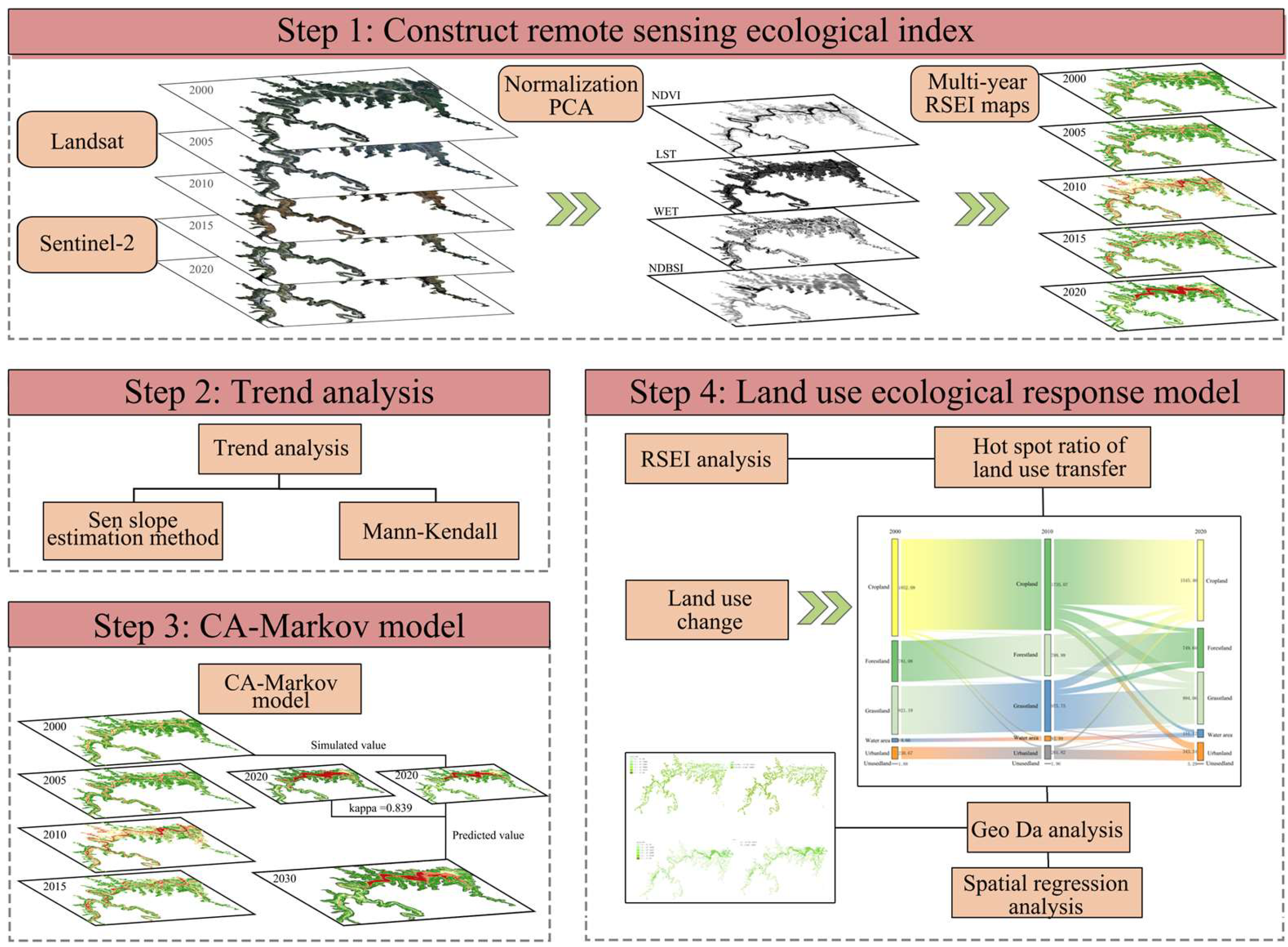
2.2.2. Research Framework
2.3. Calculation of RSEI
- (1)
- NDVI
- (2)
- WET
- (3)
- LST
- (4)
- NDBSI
- (5)
- Construction of the RSEI
2.4. Trend Analysis and Consistency Test
2.5. CA-Markov Model
2.6. Land Use Ecological Response Model
3. Results
3.1. Quality Evaluation of the RSEI
3.1.1. Principal Component Analysis
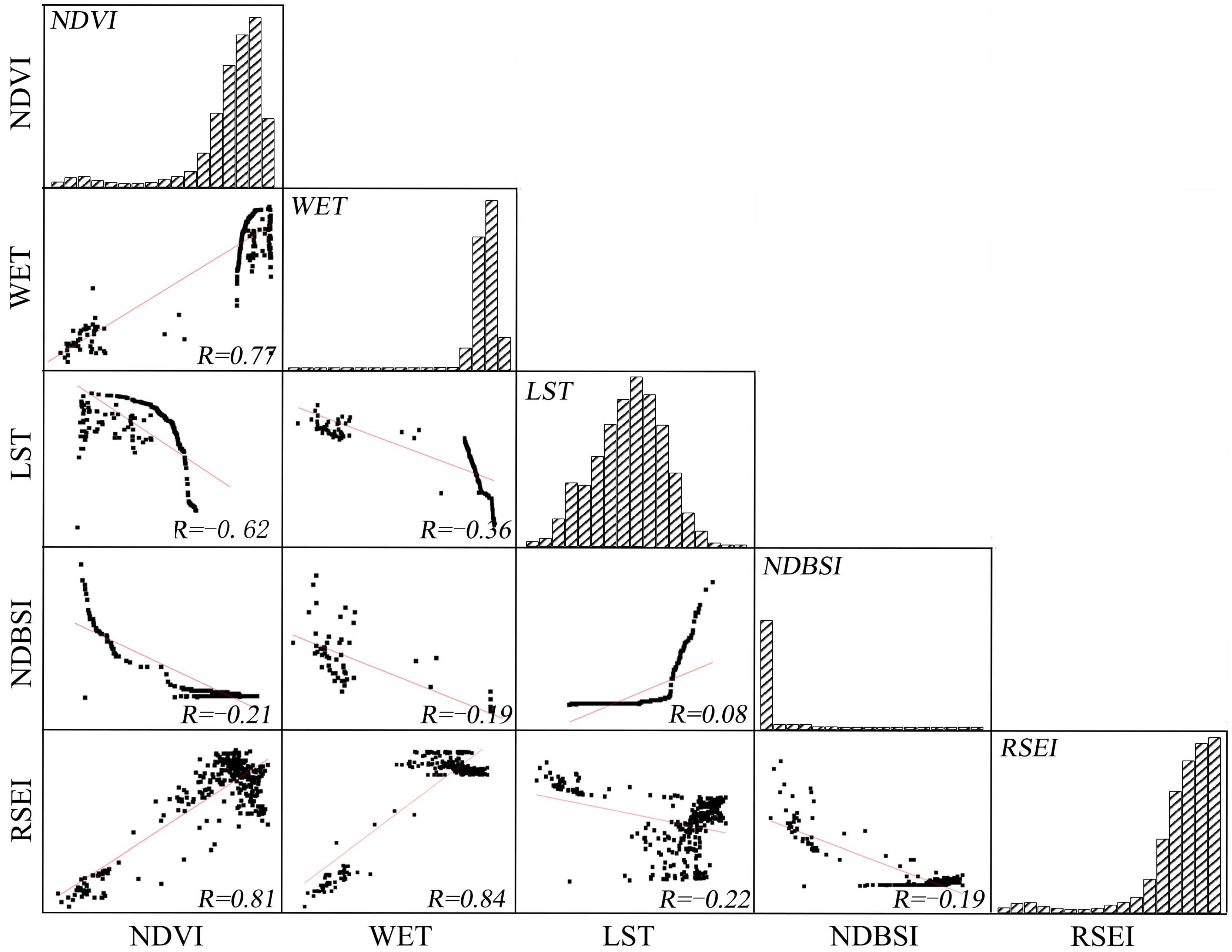
3.1.2. Indicator Correlation Analysis
3.2. Spatiotemporal Characteristics of the EEQ in the Qianping Reservoir
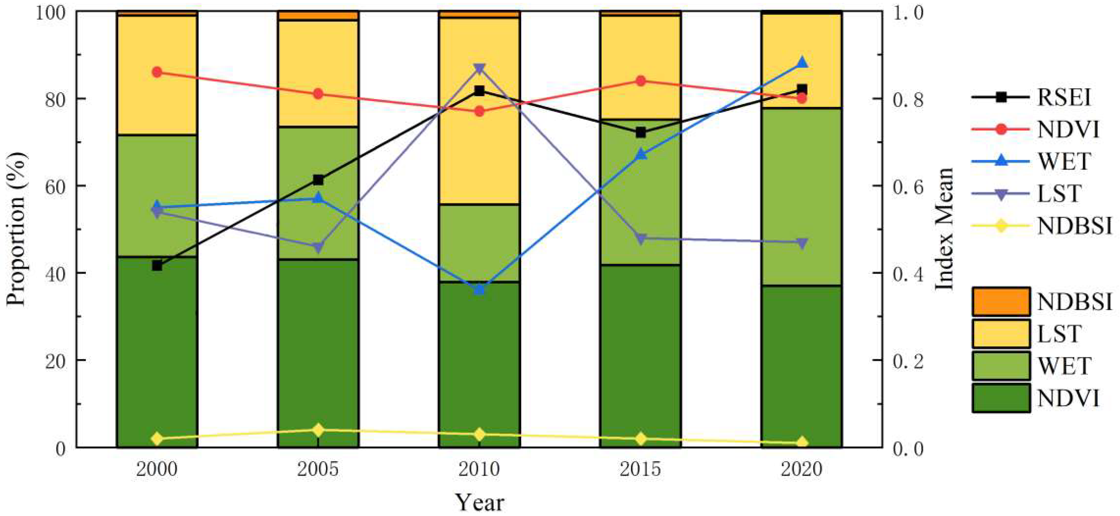
3.2.1. Temporal Variation Characteristics
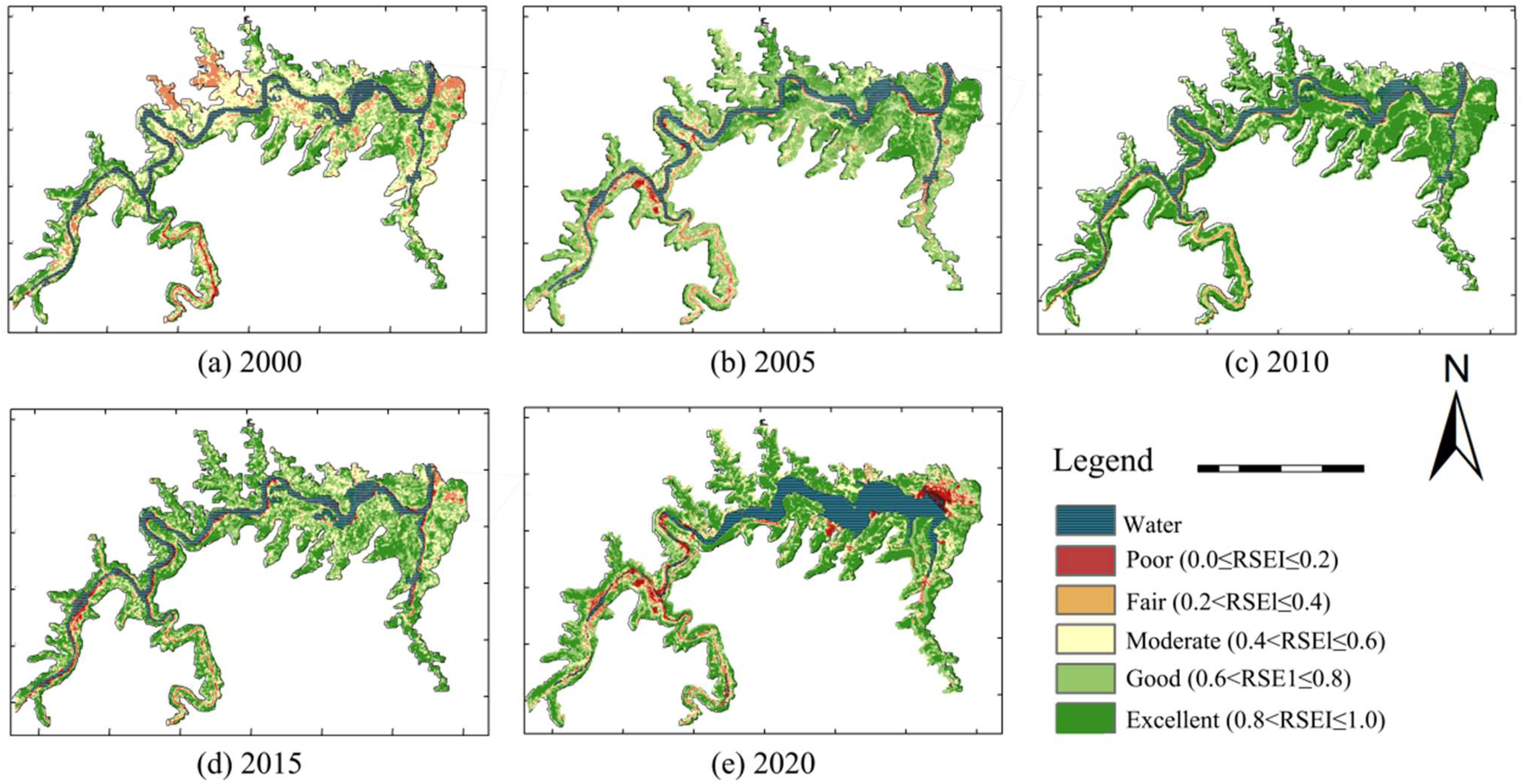
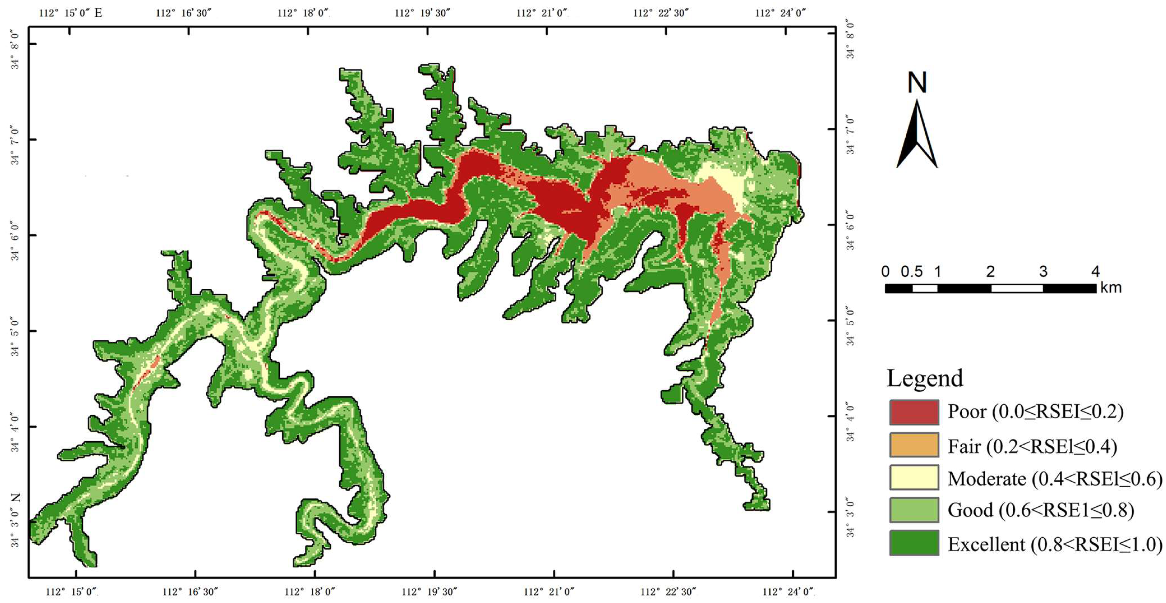
3.2.2. Spatial Variation Characteristics
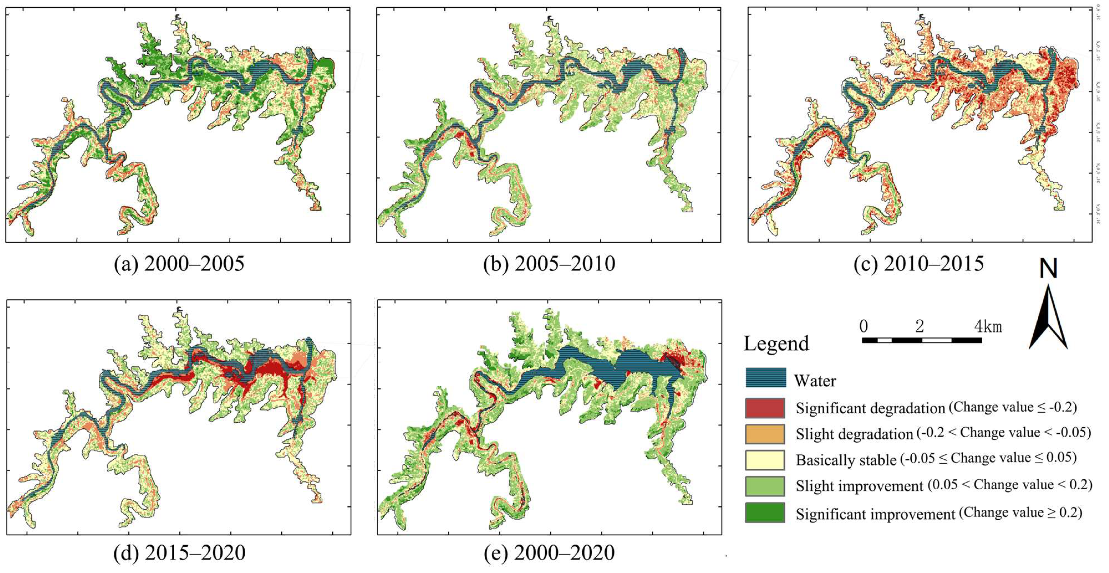
3.3. Changing Trends
3.4. CA-Markov Model Prediction
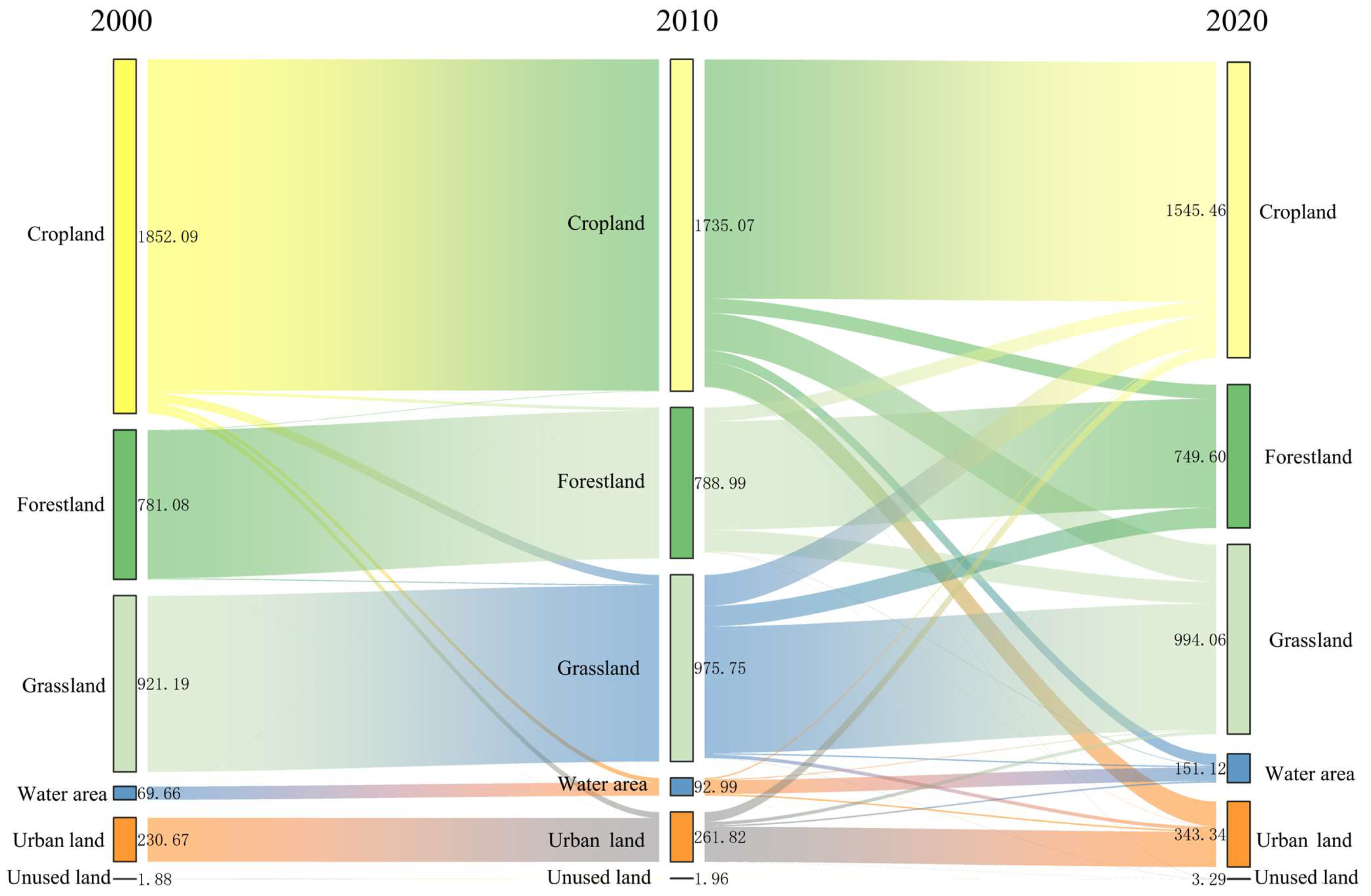
3.5. Analysis of Ecological Responses to Land Use Changes
4. Discussion
4.1. Effectiveness and Suitability of the RSEI for Analyzing EEQ in Reservoir Areas
4.2. Spatiotemporal Characteristics of Changes in EEQ
4.3. Trends and Influencing Factors in EEQ
4.4. Limitations
5. Recommendations
- Implement strict cultivated land protection policies to counter progressive farmland loss (279.97 hm2 net reduction since 2000), coupled with precision agriculture technologies to enhance land productivity while balancing urban–rural development needs.
- Reconstruct multi-layered vegetation communities (tree–shrub–herb mosaics) in dam-adjacent areas using native flood/drought-resilient species, addressing acute vegetation degradation post-construction.
- Stabilize hydrologically sensitive slopes through root-intensive shrubs and pollutant-filtering herbaceous covers to mitigate water level fluctuation impacts.
- Apply soil-bioengineering techniques (e.g., rain-harvesting terraces, geotextile-reinforced planting) on bare slopes to rebuild erosion-resistant plant communities.
6. Conclusions
Author Contributions
Funding
Data Availability Statement
Conflicts of Interest
References
- Zheng, Z.; Wu, Z.; Chen, Y.; Yang, Z.; Marinello, F. Exploration of Eco-Environment and Urbanization Changes in Coastal Zones: A Case Study in China over the Past 20 Years. Ecol. Indic. 2020, 119, 106847. [Google Scholar] [CrossRef]
- Cabral, A.I.; Costa, F.L. Land Cover Changes and Landscape Pattern Dynamics in Senegal and Guinea Bissau Borderland. Appl. Geogr. 2017, 82, 115–128. [Google Scholar] [CrossRef]
- Wang, J.; Ding, Y.; Wang, S.; Watson, A.E.; He, H.; Ye, H.; Ouyang, X.; Li, Y. Pixel-Scale Historical-Baseline-Based Ecological Quality: Measuring Impacts from Climate Change and Human Activities from 2000 to 2018 in China. J. Environ. Manag. 2022, 313, 114944. [Google Scholar] [CrossRef]
- Wang, X. Advances in Separating Effects of Climate Variability and Human Activity on Stream Discharge: An Overview. Adv. Water Resour. 2014, 71, 209–218. [Google Scholar] [CrossRef]
- Cudennec, C.; Leduc, C.; Koutsoyiannis, D. Dryland Hydrology in Mediterranean Regions—A Review. Hydrol. Sci. J. 2007, 52, 1077–1087. [Google Scholar] [CrossRef]
- Cooper, S.D.; Lake, P.S.; Sabater, S.; Melack, J.M.; Sabo, J.L. The Effects of Land Use Changes on Streams and Rivers in Mediterranean Climates. Hydrobiologia 2013, 719, 383–425. [Google Scholar] [CrossRef]
- Belmar, O.; Velasco, J.; Martinez-Capel, F.; Marín, A.A.; Martínez-Capel, F. Natural Flow Regime, Degree of Alteration and Environmental Ows in the Mula Stream (Segura River Basin, SE Spain). Limnetica 2010, 29, 0353–0368. [Google Scholar] [CrossRef]
- Grill, G.; Lehner, B.; Thieme, M.; Geenen, B.; Tickner, D.; Antonelli, F.; Babu, S.; Borrelli, P.; Cheng, L.; Crochetiere, H. Mapping the World’s Free-Flowing Rivers. Nature 2019, 569, 215–221. [Google Scholar] [CrossRef]
- Han, L.; Huo, H.; Liu, Z.; Zhao, Y.-H.; Zhu, H.-L.; Chen, R.; Zhao, Z.-L. Spatial and Temporal Variations of Vegetation Coverage in the Middle Section of Yellow River Basin Based on Terrain Gradient: Taking Yan’an City as an Example. Ying Yong Sheng Tai Xue Bao (J. Appl. Ecol.) 2021, 32, 1581–1592. [Google Scholar]
- Gupta, K.; Kumar, P.; Pathan, S.K.; Sharma, K.P. Urban Neighborhood Green Index—A Measure of Green Spaces in Urban Areas. Landsc. Urban Plan. 2012, 105, 325–335. [Google Scholar] [CrossRef]
- Zhang, Y.; Odeh, I.O.; Han, C. Bi-Temporal Characterization of Land Surface Temperature in Relation to Impervious Surface Area, NDVI and NDBI, Using a Sub-Pixel Image Analysis. Int. J. Appl. Earth Obs. Geoinf. 2009, 11, 256–264. [Google Scholar] [CrossRef]
- Xu, H. A New Index for Delineating Built-up Land Features in Satellite Imagery. Int. J. Remote Sens. 2008, 29, 4269–4276. [Google Scholar] [CrossRef]
- Gao, P.; Kasimu, A.; Zhao, Y.; Lin, B.; Chai, J.; Ruzi, T.; Zhao, H. Evaluation of the Temporal and Spatial Changes of Ecological Quality in the Hami Oasis Based on RSEI. Sustainability 2020, 12, 7716. [Google Scholar] [CrossRef]
- Liu, X.; Zhou, Q.; Zhou, L.; Meng, H.; Li, M.; Peng, C. RSEI-Based Dynamic Monitoring of Ecological Quality of the Soil and Water Conservation Functional Area in the Chongqing Section of the Three Gorges Reservoir Area. Res. Soil Water Conserv. 2021, 28, 278–286. [Google Scholar]
- Chang, W.; Wang, H.; Ning, X.; Zhang, H. Extraction of Zhalong Wetlands Information Based on Images of Sentinel-2 Red-Edge Bands and Sentinel-1 Radar Bands. Wetl. Sci. 2020, 18, 10–19. [Google Scholar]
- Zhang, X.; Liu, X.; Zhao, Z.; Ma, Y.; Yang, Y. Dynamic Monitoring of Ecology and Environment in the Agro-Pastral Ecotone Based on Remote Sensing: A Case of Yanchi County in Ningxia Hui Autonomous Region. Arid Land Geogr. 2017, 40, 1070. [Google Scholar]
- Xu, H.Q.; Shi, T.T.; Wang, M.Y.; Lin, Z.L. Land Cover Changes in the Xiong’an New Area and a Prediction of Ecological Response to Forthcoming Regional Planning. Acta Ecol. Sin. 2017, 37, 6289–6301. [Google Scholar]
- Nong, L.; Wang, J. Dynamic Monitoring of Ecological Environment Quality in Kunming Based on RSEI Model. Chin. J. Ecol. 2020, 39, 2042. [Google Scholar]
- Zhou, J.; Liu, W. Monitoring and Evaluation of Eco-Environment Quality Based on Remote Sensing-Based Ecological Index (RSEI) in Taihu Lake Basin, China. Sustainability 2022, 14, 5642. [Google Scholar] [CrossRef]
- Lin, M.S.; Lin, J.H.; Cheng, Y.; Wang, X.; Zhang, M.; Qi, X. Ecological Vulnerability Assessment of Key Villages of Tourism Poverty Alleviation in Fujian Province. Acta Ecol. Sin. 2018, 38, 7093–7101. [Google Scholar]
- Aburas, M.M.; Abdullah, S.H.; Ramli, M.F.; Ash’aari, Z.H. Measuring Land Cover Change in Seremban, Malaysia Using NDVI Index. Procedia Environ. Sci. 2015, 30, 238–243. [Google Scholar] [CrossRef]
- Omar, M.S.; Kawamukai, H. Prediction of NDVI Using the Holt-Winters Model in High and Low Vegetation Regions: A Case Study of East Africa. Sci. Afr. 2021, 14, e01020. [Google Scholar] [CrossRef]
- Crist, E.P. A TM Tasseled Cap Equivalent Transformation for Reflectance Factor Data. Remote Sens. Environ. 1985, 17, 301–306. [Google Scholar] [CrossRef]
- Zhang, Y.; Chen, L.; Wang, Y.; Chen, L.; Yao, F.; Wu, P.; Wang, B.; Li, Y.; Zhou, T.; Zhang, T. Research on the Contribution of Urban Land Surface Moisture to the Alleviation Effect of Urban Land Surface Heat Based on Landsat 8 Data. Remote Sens. 2015, 7, 10737–10762. [Google Scholar] [CrossRef]
- Li, A.; Wang, A.; Liang, S.; Zhou, W. Eco-Environmental Vulnerability Evaluation in Mountainous Region Using Remote Sensing and GIS—A Case Study in the Upper Reaches of Minjiang River, China. Ecol. Model. 2006, 192, 175–187. [Google Scholar] [CrossRef]
- Nichol, J. Remote Sensing of Urban Heat Islands by Day and Night. Photogramm. Eng. Remote Sens. 2005, 71, 613–621. [Google Scholar] [CrossRef]
- Wang, C.; Jiang, Q.; Engel, B.; Mercado, J.A.V.; Zhang, Z. Analysis on Net Primary Productivity Change of Forests and Its Multi–Level Driving Mechanism–A Case Study in Changbai Mountains in Northeast China. Technol. Forecast. Soc. Change 2020, 153, 119939. [Google Scholar] [CrossRef]
- Wu, K.; Gao, Q.; Wang, R.; Yang, P.; Peng, Q.; Liu, C. Evaluation of Ecological Environment Quality in Shijiazhuang Based on RSEI Model. Prog. Geophys. 2021, 36, 968–976. [Google Scholar]
- Hong, J.-H.; Su, Z.L.-T.; Lu, E.H.-C. Spatial Perspectives toward the Recommendation of Remote Sensing Images Using the INDEX Indicator, Based on Principal Component Analysis. Remote Sens. 2020, 12, 1277. [Google Scholar] [CrossRef]
- Wu, Y.J.; Zhao, X.; Xi, Y.; Liu, H.; Li, C. Comprehensive Evaluation and Spatial-Temporal Changes of Eco-Environmental Quality Based on MODIS in Tibet during 2006–2016. Acta Geogr. Sin. 2019, 74, 1438–1449. [Google Scholar]
- Sen, P.K. Estimates of the Regression Coefficient Based on Kendall’s Tau. J. Am. Stat. Assoc. 1968, 63, 1379–1389. [Google Scholar] [CrossRef]
- Kendall, M.G.; Gibbons, J.D. Rank Correlation Methods, 4th ed.; Charles Griffin: London, UK, 1975. [Google Scholar]
- Song, W.; Gu, H.-H.; Song, W.; Li, F.-P.; Cheng, S.-P.; Zhang, Y.-X.; Ai, Y.-J. Environmental Assessments in Dense Mining Areas Using Remote Sensing Information over Qian’an and Qianxi Regions China. Ecol. Indic. 2023, 146, 109814. [Google Scholar] [CrossRef]
- Shukla, S.; Gedam, S. Assessing the Impacts of Urbanization on Hydrological Processes in a Semi-Arid River Basin of Maharashtra, India. Model. Earth Syst. Environ. 2018, 4, 699–728. [Google Scholar] [CrossRef]
- Qin, Q.T.; Chen, J.J.; Yang, Y.P.; Zhao, X.Y.; Zhou, G.Q.; You, H.T.; Han, X.W. Spatiotemporal Variations of Vegetation and Its Response to Topography and Climate in the Source Region of the Yellow River. China Environ. Sci. 2021, 41, 3832–3841. [Google Scholar]
- Ning, X.; Zhu, N.; Liu, Y.; Wang, H. Quantifying Impacts of Climate and Human Activities on the Grassland in the Three-River Headwater Region after Two Phases of Ecological Project. Geogr. Sustain. 2022, 3, 164–176. [Google Scholar] [CrossRef]
- Hu, F.; Zhang, Y.; Guo, Y.; Zhang, P.; Lyu, S.; Zhang, C. Spatial and Temporal Changes in Land Use and Habitat Quality in the Weihe River Basin Based on the PLUS and InVEST Models and Predictions. Arid Land Geogr. 2022, 45, 1125–1136. [Google Scholar]
- Surabuddin Mondal, M.; Sharma, N.; Kappas, M.; Garg, P.K. Ca Markov Modeling of Land Use Land Cover Dynamics and Sensitivity Analysis to Identify Sensitive Parameter (S). Int. Arch. Photogramm. Remote Sens. Spat. Inf. Sci. 2019, 42, 723–729. [Google Scholar] [CrossRef]
- Freeman, M.C.; Marcinek, P.A. Fish Assemblage Responses to Water Withdrawals and Water Supply Reservoirs in Piedmont Streams. Environ. Manag. 2006, 38, 435–450. [Google Scholar] [CrossRef]
- Wang, L.X.; Zhao, R.; Liu, Z.; Zhang, S.C.; Kong, J.; Yang, Y. Monitoring and Prediction of Ecological Environmental Quality in the Yanhe River Basin Based on the Remote Sensing Ecological Index. Arid Zone Res. 2022, 39, 943–954. [Google Scholar]
- Asif, M.; Kazmi, J.H.; Tariq, A.; Zhao, N.; Guluzade, R.; Soufan, W.; Almutairi, K.F.; Sabagh, A.E.; Aslam, M. Modelling of Land Use and Land Cover Changes and Prediction Using CA-Markov and Random Forest. Geocarto Int. 2023, 38, 2210532. [Google Scholar] [CrossRef]
- Zhao, Y.H.; Jia, X.; Liu, J.C.; Liu, G. Analysis and Forecast of Landscape Pattern in Xi’an from 2000 to 2011. Acta Ecol. Sin. 2013, 33, 2556–2564. [Google Scholar] [CrossRef]
- Chen, W.; Huang, H.; Tian, Y.; Du, Y.Y. Monitoring and Assessment of the Eco-Environment Quality in the Sanjiangyuan Region Based on Google Earth Engine. J. Geo-Inf. Sci. 2019, 21, 1382–1391. [Google Scholar]
- Wang, F.; Li, W.-H.; Lin, Y.-M.; Nan, X.-X.; Hu, Z.-R. Spatiotemporal Pattern and Driving Force Analysis of Ecological Environmental Quality in Typical Ecological Areas of the Yellow River Basin from 1990 to 2020. Huan Jing Ke Xue 2023, 44, 2518–2527. [Google Scholar]
- Quan, W.T.; Zhang, S.Y.; Liu, Y.; Wang, W.D. Monitoring and Evaluation of Ecological Environment Changes in Dongzhuang Reservoir Basin in Shaanxi Province Based on Remote Sensing Ecological Index. Bull. Soil Water Conserv. 2022, 42, 96–104. [Google Scholar]
- Li, X.; Liu, J.P.; Saito, Y.; Nguyen, V.L. Recent Evolution of the Mekong Delta and the Impacts of Dams. Earth-Sci. Rev. 2017, 175, 1–17. [Google Scholar]
- Shumba, A.; Gumindoga, W.; Togarepi, S.; Edward, T.P.M. A Remote Sensing and GIS Based Application for Monitoring Water Levels at Kariba Dam. In Proceedings of the ACRID 2017: EAI International Conference for Research, Innovation and Development for Africa, European Alliance for Innovation, Bratislava, Slovakia, 20 June 2017; p. 150. [Google Scholar]
- Guo, H.; Wang, Y.; Yu, J.; Yi, L.; Shi, Z.; Wang, F. A Novel Framework for Vegetation Change Characterization from Time Series Landsat Images. Environ. Res. 2023, 222, 115379. [Google Scholar] [CrossRef]
- Ke, R.; Mei, Z. Analysis on the Influence of Urbanization and Greenland-Degradation on City Thermal Environment. Ecol. Environ. 2010, 19, 2023. [Google Scholar]
- Zou, T.; Chang, Y.; Chen, P.; Liu, J. Spatial-Temporal Variations of Ecological Vulnerability in Jilin Province (China), 2000 to 2018. Ecol. Indic. 2021, 133, 108429. [Google Scholar] [CrossRef]
- An, M.; Xie, P.; He, W.; Wang, B.; Huang, J.; Khanal, R. Local and Tele-Coupling Development between Carbon Emission and Ecologic Environment Quality. J. Clean. Prod. 2023, 394, 136409. [Google Scholar] [CrossRef]


| Data Type | Resolution | Time | Source |
|---|---|---|---|
| Landsat | 10 m | 2000/2005/2010/2015 | http://www.gscloud.cn accessed on 9 June 2023 |
| Sentinel-2 | 10 m | 2020 | https://www.esa.int/ (European Space Agency) accessed on 9 June 2023 |
| DEM | 12.5 m | 2020 | http://www.gscloud.cn accessed on 9 June 2023 |
| NDVI | 30 m | 2000–2020 | http://www.gscloud.cn accessed on 9 June 2023 |
| Land cover | 30 m | 2000/2005/2010/2015/2020 | https://www.gscloud.cn/ accessed on 9 June 2023 |
| Step | Process | Technical Specification | Software/Tool |
|---|---|---|---|
| 1 | RSEI Data Normalization | Min–max scaling (0–1 range) of all indices (NDVI, WET, NDBSI, LST) | ArcGIS 10.5 |
| 2 | Land Use Transition Matrix | 30 × 30 m grid analysis of 2015–2020 changes using cross-tabulation | TerrSet 18.3 |
| 3 | Hotspot Analysis | Getis-Ord Gi statistics (p < 0.05) for significant transition clusters | GeoDa 1.20 |
| 4 | Grid Difference Analysis | RSEI change = ∑(RSEI2020 − RSEI2015) per grid | Python 3.8 |
| 5 | Correlation Analysis | Pearson’s r between land type % change and ΔRSEI | GeoDa 1.20 |
| 6 | Cultivated Land Impact | OLS regression: ΔRSEI = β0 + β1(cultivated land loss) + ε | GeoDa 1.20 |
| Year | Indicator | PC1 | PC2 | PC3 | PC4 |
|---|---|---|---|---|---|
| 2000 | NDVI | 0.31 | −0.48 | −0.55 | 0.54 |
| WET | 0.47 | 0.52 | 0.47 | 0.37 | |
| LST | −0.37 | −0.31 | 0.57 | 0.46 | |
| NDBSI | −0.49 | 0.58 | −0.49 | 0.41 | |
| Eigenvalue | 0.089 | 0.024 | 0.009 | 0.001 | |
| Contribution rate (%) | 80.47 | 12.63 | 5.68 | 1.22 | |
| 2005 | NDVI | 0.47 | −0.54 | −0.36 | 0.52 |
| WET | 0.49 | 0.46 | 0.52 | 0.46 | |
| LST | −0.41 | −0.40 | −0.54 | 0.49 | |
| NDBSI | −0.56 | 0.56 | 0.47 | 0.47 | |
| Eigenvalue | 0.078 | 0.019 | 0.011 | 0.001 | |
| Contribution rate (%) | 76.61 | 13.15 | 9.57 | 0.67 | |
| 2010 | NDVI | 0.56 | −0.48 | −0.39 | 0.38 |
| WET | 0.52 | 0.51 | 0.48 | 0.42 | |
| LST | −0.45 | −0.54 | −0.44 | 0.55 | |
| NDBSI | −0.62 | 0.45 | 0.55 | 0.58 | |
| Eigenvalue | 0.069 | 0.027 | 0.012 | 0.001 | |
| Contribution rate (%) | 70.38 | 18.98 | 9.55 | 1.09 | |
| 2015 | NDVI | 0.51 | −0.47 | −0.39 | 0.44 |
| WET | 0.47 | 0.48 | 0.47 | 0.51 | |
| LST | −0.39 | −0.51 | 0.55 | 0.38 | |
| NDBSI | −0.52 | −0.49 | −0.42 | 0.41 | |
| Eigenvalue | 0.076 | 0.021 | 0.015 | 0.001 | |
| Contribution rate (%) | 76.43 | 12.49 | 10.35 | 0.73 | |
| 2020 | NDVI | 0.66 | −0.17 | 0.50 | −0.53 |
| WET | 0.17 | −0.20 | −0.82 | −0.50 | |
| LST | −0.39 | −0.91 | 0.16 | −0.04 | |
| NDBSI | −0.61 | 0.33 | 0.21 | −0.69 | |
| Eigenvalue | 0.066 | 0.019 | 0.014 | 0.001 | |
| Contribution rate (%) | 65.29 | 19.24 | 14.31 | 1.15 |
| Simulated RSEI Levels | Total Points | ||||||
|---|---|---|---|---|---|---|---|
| Excellent | Good | Moderate | Fair | Poor | |||
| Calculated RSEI levels | Excellent | 135 | 12 | 0 | 1 | 1 | 149 |
| Good | 11 | 66 | 4 | 2 | 2 | 85 | |
| Moderate | 0 | 3 | 14 | 0 | 0 | 17 | |
| Fair | 0 | 1 | 6 | 10 | 4 | 21 | |
| Poor | 0 | 0 | 0 | 1 | 25 | 26 | |
| Total | 146 | 82 | 24 | 14 | 32 | 298 | |
Disclaimer/Publisher’s Note: The statements, opinions and data contained in all publications are solely those of the individual author(s) and contributor(s) and not of MDPI and/or the editor(s). MDPI and/or the editor(s) disclaim responsibility for any injury to people or property resulting from any ideas, methods, instructions or products referred to in the content. |
© 2025 by the authors. Licensee MDPI, Basel, Switzerland. This article is an open access article distributed under the terms and conditions of the Creative Commons Attribution (CC BY) license (https://creativecommons.org/licenses/by/4.0/).
Share and Cite
Xu, E.; Zhang, G.; Wang, H.; Yang, M.; Tian, H.; Zhao, M.; Dong, N.; Li, C.; Hu, Y.; Tian, G.; et al. Monitoring and Assessing Ecological Environmental Quality in Qianping Reservoir, Central China: A Remote Sensing Ecological Index (RSEI) Approach. Forests 2025, 16, 831. https://doi.org/10.3390/f16050831
Xu E, Zhang G, Wang H, Yang M, Tian H, Zhao M, Dong N, Li C, Hu Y, Tian G, et al. Monitoring and Assessing Ecological Environmental Quality in Qianping Reservoir, Central China: A Remote Sensing Ecological Index (RSEI) Approach. Forests. 2025; 16(5):831. https://doi.org/10.3390/f16050831
Chicago/Turabian StyleXu, Enkai, Guohang Zhang, Hua Wang, Mei Yang, Hao Tian, Ming Zhao, Nalin Dong, Congshi Li, Yongge Hu, Guohang Tian, and et al. 2025. "Monitoring and Assessing Ecological Environmental Quality in Qianping Reservoir, Central China: A Remote Sensing Ecological Index (RSEI) Approach" Forests 16, no. 5: 831. https://doi.org/10.3390/f16050831
APA StyleXu, E., Zhang, G., Wang, H., Yang, M., Tian, H., Zhao, M., Dong, N., Li, C., Hu, Y., Tian, G., Lei, Y., Chen, Q., & Wei, D. (2025). Monitoring and Assessing Ecological Environmental Quality in Qianping Reservoir, Central China: A Remote Sensing Ecological Index (RSEI) Approach. Forests, 16(5), 831. https://doi.org/10.3390/f16050831