
A Comparative Study Between Gaofen-1 WFV and Sentinel MSI Imagery for Fire Severity Assessment in a Karst Region, China


Abstract
1. Introduction
2. Materials and Methods
2.1. Fire Events
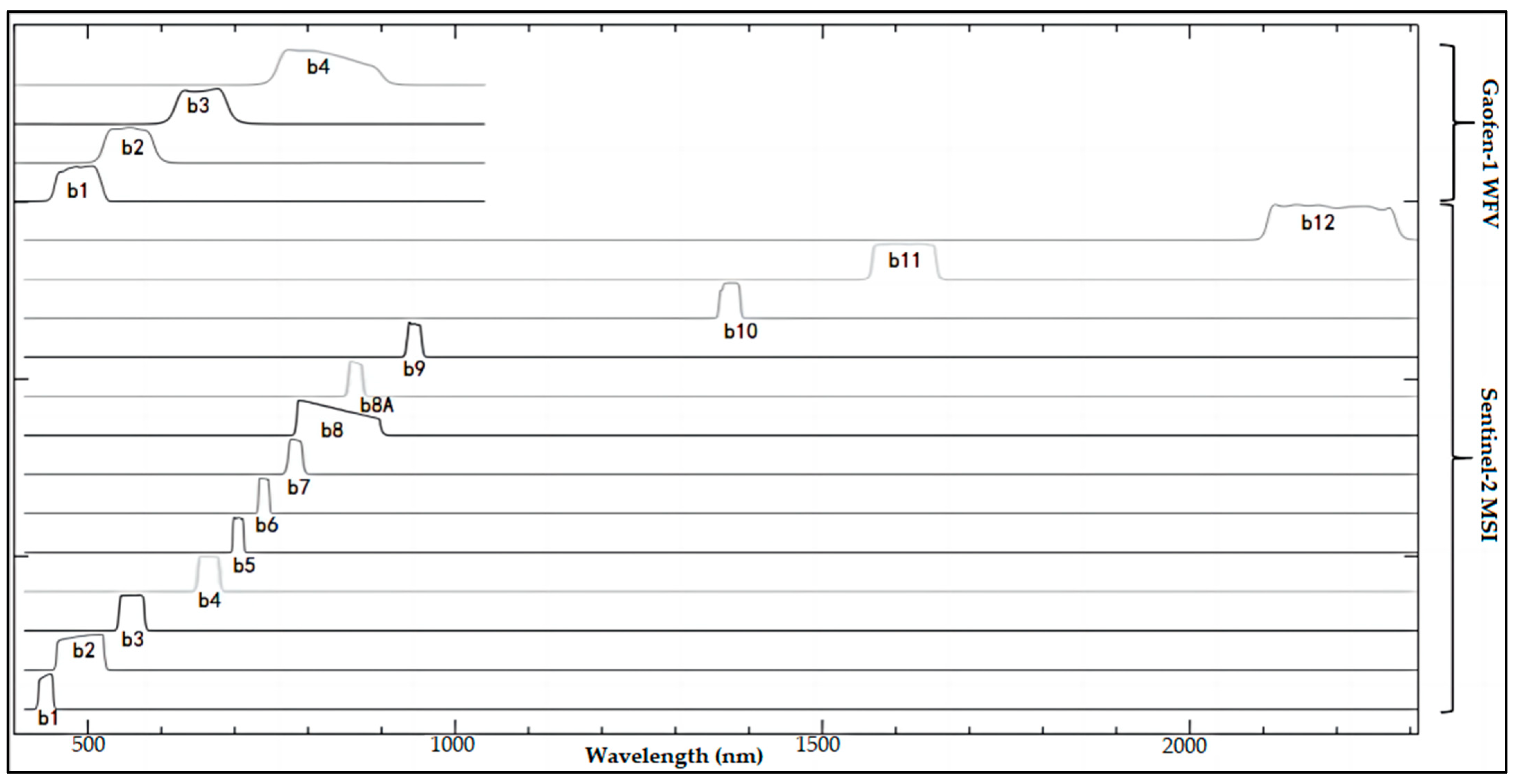
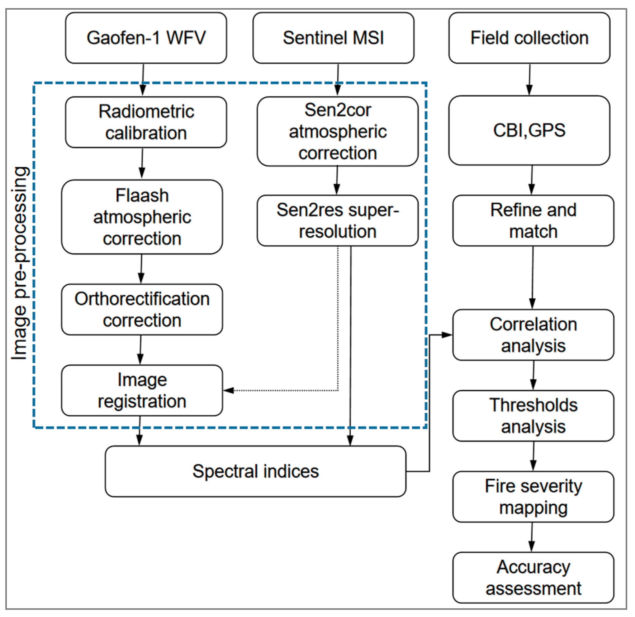
2.2. Imagery and Preprocessing
2.3. Fire Severity Spectral Indices
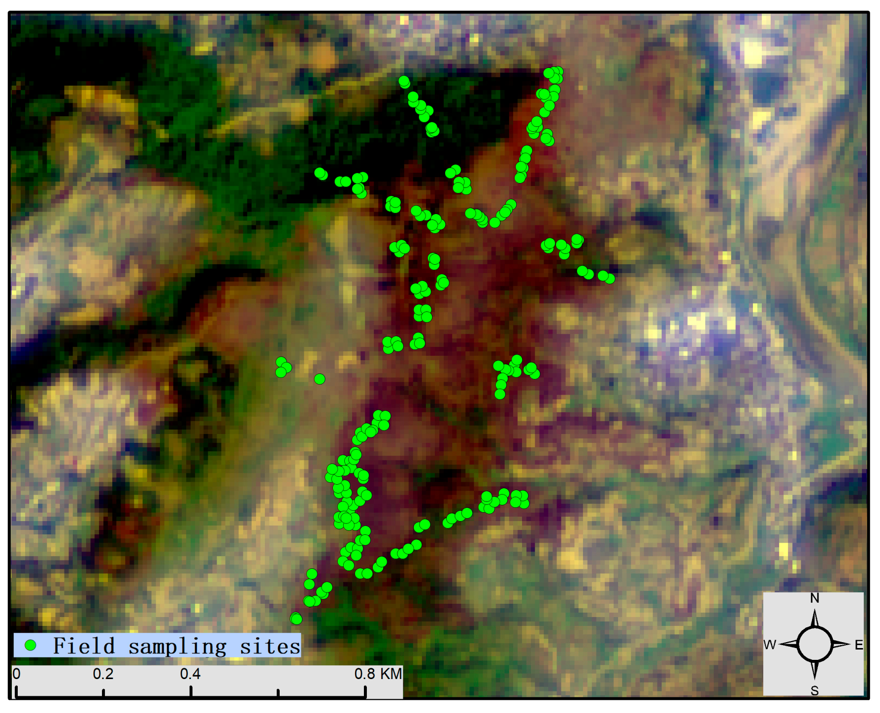
2.4. Field Survey Data
2.5. Statistical Analyses
3. Results and Discussion
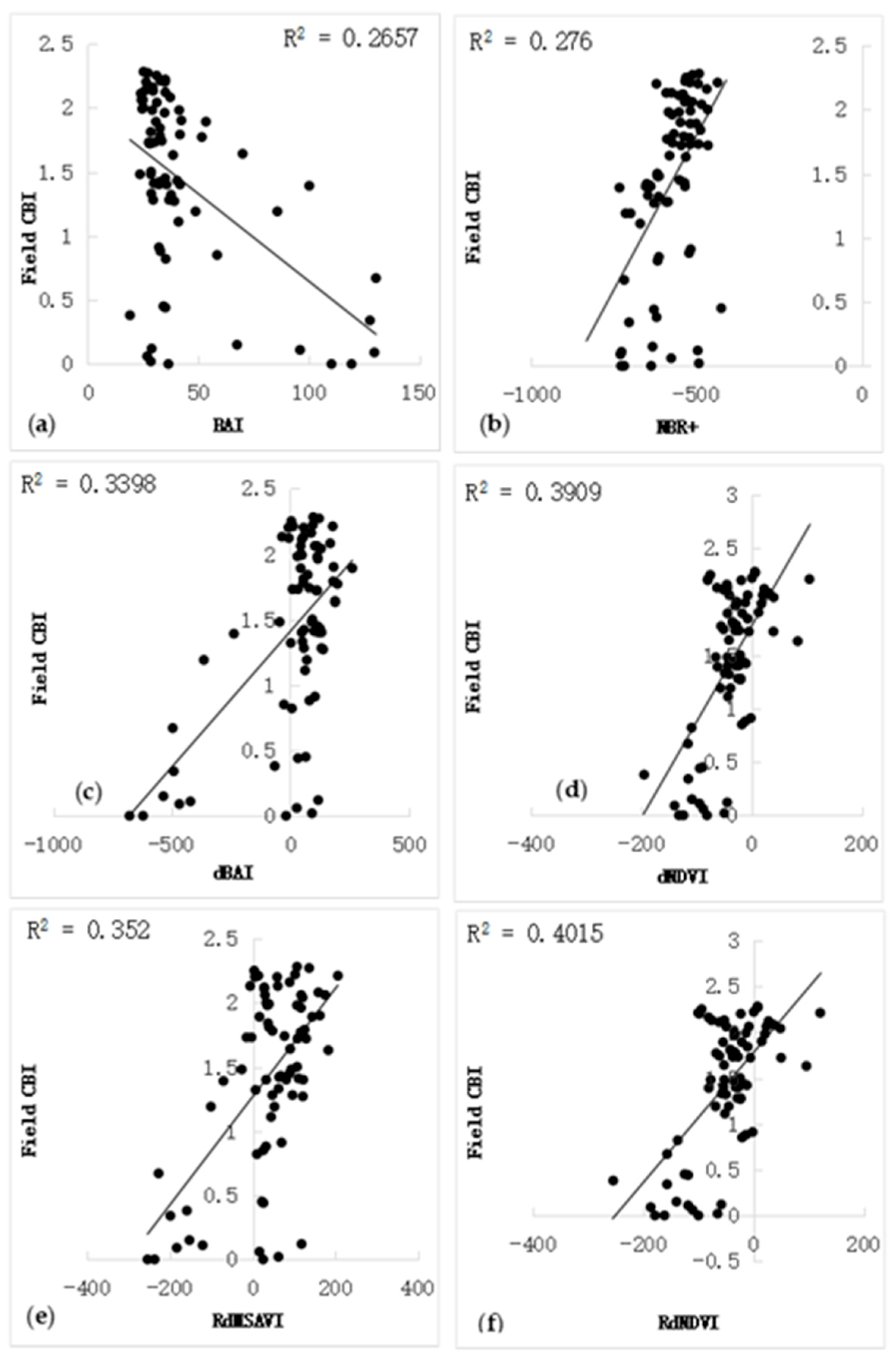
3.1. The Comparative Analysis of Different Indices in Fire Severity Assessment
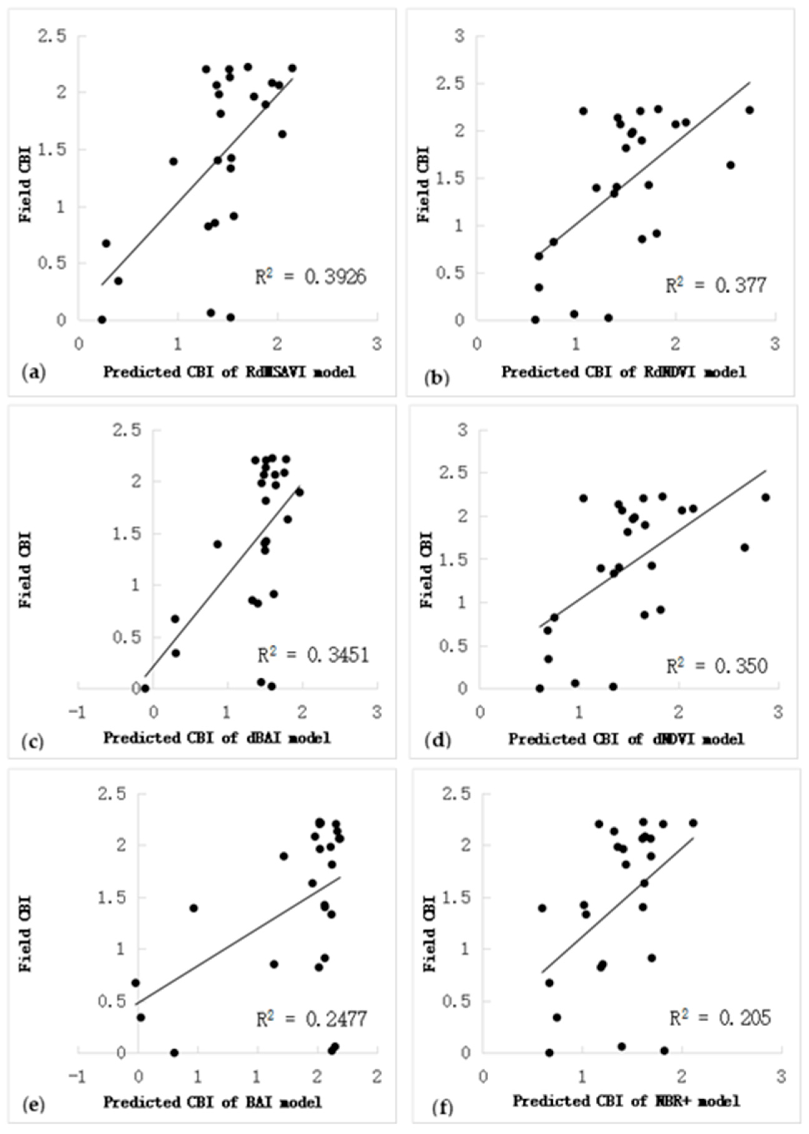
3.2. The Fire Severity Model Construction
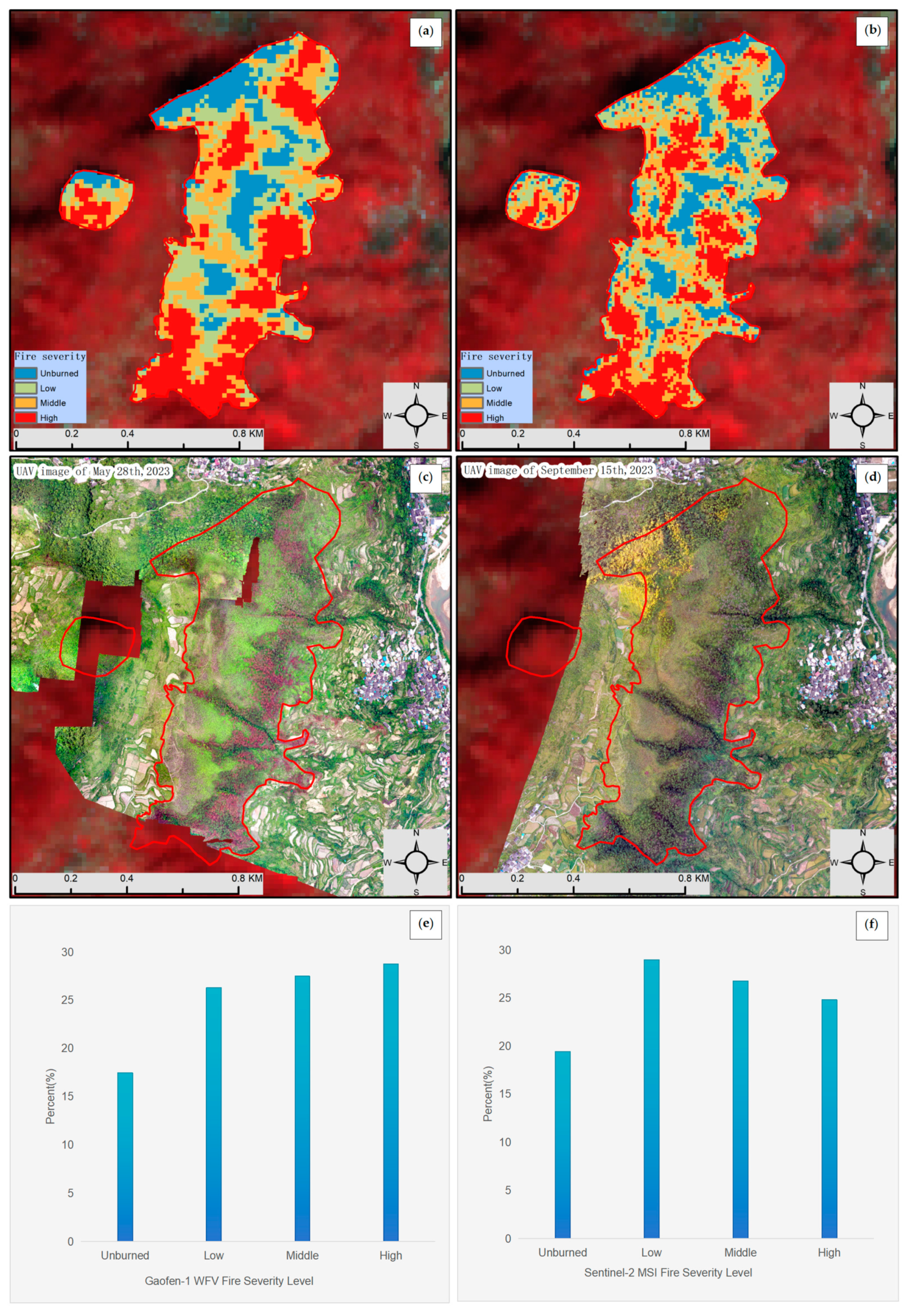
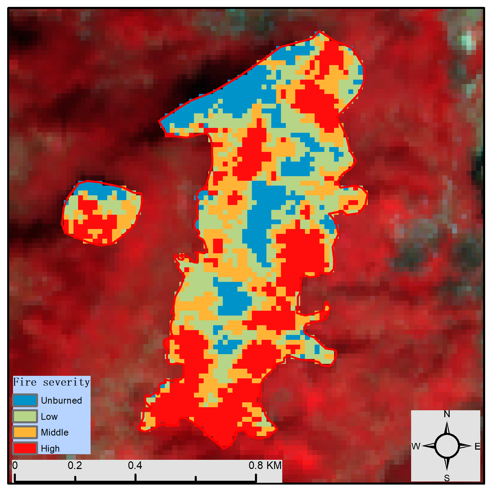
3.3. Fire Severity Mapping
3.4. Discussion
4. Conclusions
Author Contributions
Funding
Data Availability Statement
Acknowledgments
Conflicts of Interest
Abbreviations
| WFV | Wide Field of View |
| MSI | Multispectral Imager |
| RMSE | root mean square error |
| UAV | unmanned aerial vehicle |
Appendix A

| Site No. | ABC * | DE * | ABCDE * | Site No. | ABC * | DE * | ABCDE * |
|---|---|---|---|---|---|---|---|
| 1 | 2.06 | / | 2.06 | 39 | 1.96 | / | 1.96 |
| 2 | 2.18 | 2.31 | 2.21 | 40 | 2.17 | 2.36 | 2.22 |
| 3 | 2.16 | / | 2.16 | 41 | 1.89 | 2.26 | 1.98 |
| 4 | 2.28 | / | 2.28 | 42 | 2.2 | / | 2.2 |
| 5 | 1.72 | / | 1.72 | 43 | 1.61 | 1.15 | 1.32 |
| 6 | 2.04 | / | 2.04 | 44 | 1.84 | 1.42 | 1.74 |
| 7 | 1.84 | / | 1.84 | 45 | 2.04 | 1.8 | 1.98 |
| 8 | 2 | 0.88 | 1.72 | 46 | 2.1 | 2.19 | 2.12 |
| 9 | 1.92 | 0.25 | 1.5 | 47 | 2.1 | 2.2 | 2.13 |
| 10 | 2.13 | / | 2.13 | 48 | 2.2 | / | 2.2 |
| 11 | 1.68 | 0.27 | 1.33 | 49 | 2 | / | 2 |
| 12 | 1.74 | 0.46 | 1.42 | 50 | 1.63 | 0.59 | 1.28 |
| 13 | 1.81 | 0.49 | 1.48 | 51 | 1.59 | 1.01 | 1.4 |
| 14 | 1.87 | 0.5 | 1.41 | 52 | 0.45 | 0 | 0.34 |
| 15 | 1.61 | 0.24 | 1.27 | 53 | 0.12 | 0 | 0.09 |
| 16 | 1.48 | / | 1.48 | 54 | 0.89 | 0 | 0.67 |
| 17 | 2.06 | / | 2.06 | 55 | 0 | 0 | 0 |
| 18 | 2.27 | / | 2.27 | 56 | 0 | 0 | 0 |
| 19 | 1.81 | / | 1.81 | 57 | 0.15 | / | 0.15 |
| 20 | 1.89 | / | 1.89 | 58 | 0.06 | / | 0.06 |
| 21 | 1.33 | 0.09 | 0.91 | 59 | 0.02 | / | 0.02 |
| 22 | 2.23 | 0.72 | 1.73 | 60 | 0.12 | / | 0.12 |
| 23 | 1.14 | 0.09 | 0.88 | 61 | 0.45 | / | 0.45 |
| 24 | 1.72 | 0.42 | 1.4 | 62 | 0.38 | / | 0.38 |
| 25 | 1.44 | 0.43 | 1.19 | 63 | 0.82 | / | 0.82 |
| 26 | 1.59 | 0.14 | 1.11 | 64 | 0 | / | 0 |
| 27 | 1.73 | / | 1.73 | 65 | 2.25 | / | 2.25 |
| 28 | 1.45 | / | 1.45 | 66 | 2.08 | 0.88 | 1.78 |
| 29 | 1.56 | 0.43 | 1.28 | 67 | 2.13 | 2.46 | 2.21 |
| 30 | 1.42 | 1.44 | 1.43 | 68 | 2.11 | / | 2.11 |
| 31 | 2.1 | 2.01 | 2.08 | 69 | 2.06 | / | 2.06 |
| 32 | 2.07 | 0.75 | 1.63 | 70 | 1.99 | / | 1.99 |
| 33 | 1.47 | 1.19 | 1.4 | 71 | 0.44 | / | 0.44 |
| 34 | 1.94 | 1.82 | 1.9 | 72 | 1.11 | 0.08 | 0.85 |
| 35 | 1.89 | / | 1.89 | 73 | 1.78 | 0.2 | 1.39 |
| 36 | 1.72 | 1.38 | 1.64 | 74 | 0.14 | 0.02 | 0.11 |
| 37 | 1.79 | / | 1.79 | 75 | 1.56 | 0.08 | 1.19 |
| 38 | 1.97 | 1.15 | 1.77 |
References
- Zhao, J.; Yue, C.; Wang, J.; Hantson, S.; Wang, X.; He, B.; Li, G.; Wang, L.; Zhao, H.; Luyssaert, S. Forest fire size amplifies postfire land surface warming. Nature 2024, 633, 828–834. [Google Scholar] [CrossRef] [PubMed]
- Yilmaz, O.S.; Acar, U.; Sanli, F.B.; Gulgen, F.; Ates, A.M. Mapping burn severity and monitoring CO content in Türkiye’s 2021 Wildfires, using Sentinel-2 and Sentinel-5P satellite data on the GEE platform. Earth Sci. Inform. 2023, 16, 221–240. [Google Scholar] [CrossRef]
- Liu, Z.; Yang, J. Quantifying ecological drivers of ecosystem productivity of the early-successional boreal Larix gmelinii forest. Ecosphere 2014, 5, 1–16. [Google Scholar] [CrossRef]
- Chebykina, E.Y.; Abakumov, E.V.; Kimeklis, A.K.; Gladkov, G.V.; Andronov, E.E.; Dymov, A.A. Wildfires’ Effect on Soil Properties and Bacterial Biodiversity of Postpyrogenic Histic Podzols (Middle Taiga, Komi Republic). Forests 2024, 15, 145. [Google Scholar] [CrossRef]
- Van Der Werf, G.R.; Randerson, J.T.; Giglio, L.; Van Leeuwen, T.T.; Chen, Y.; Rogers, B.M.; Mu, M.; Van Marle, M.J.; Morton, D.C.; Collatz, G.J.; et al. Global fire emissions estimates during 1997–2016. Earth Syst. Sci. Data 2017, 9, 697–720. [Google Scholar] [CrossRef]
- Mathews, L.E.H.; Kinoshita, A. Urban Fire Severity and Vegetation Dynamics in Southern California. Remote. Sens. 2021, 13, 19. [Google Scholar] [CrossRef]
- Chang, Y.; Zhu, Z.; Bu, R.; Li, Y.; Hu, Y. Environmental controls on the characteristics of mean number of forest fires and mean forest area burned (1987–2007) in China. For. Ecol. Manag. 2015, 356, 13–21. [Google Scholar] [CrossRef]
- Fang, K.; Yao, Q.; Guo, Z.; Zheng, B.; Du, J.; Qi, F.; Yan, P.; Li, J.; Ou, T.; Liu, J.; et al. ENSO modulates wildfire activity in China. Nat. Commun. 2021, 12, 1764. [Google Scholar] [CrossRef]
- Masinda, M.M.; Li, F.; Liu, Q.; Sun, L.; Hu, T. Forest Fire Risk Estimation in a Typical Temperate Forest in Northeastern China using the Canadian Forest Fire Weather Index, Case study in Autumn 2019 and 2020. Nat. Hazards 2022, 111, 1085–1101. [Google Scholar] [CrossRef]
- Yi, K.; Zhang, J. Spatial distribution and temporal variability of open fire in China. Int. J. Wildland Fire 2016, 26, 122–135. [Google Scholar] [CrossRef]
- Wu, Z.; He, H.S.; Keane, R.E.; Zhu, Z.; Wang, Y.; Shan, Y. Current and future patterns of forest fire occurrence in China. Int. J. Wildland Fire 2020, 29, 104–119. [Google Scholar] [CrossRef]
- Lian, C.; Xiao, C.; Feng, Z.; Ma, Q. Accelerating decline of wildfires in China in the 21st century. Front. For. Glob. Change 2024, 6, 1252587. [Google Scholar] [CrossRef]
- Su, J.; Gou, X.; Lambers, J.H.R.; Zhang, D.D.; Zheng, W.; Xie, M.; Manzanedo, R.D. Increasing ENSO variability synchronizes tree growth in subtropical forests. Agric. For. Meteorol. 2024, 345, 109830. [Google Scholar] [CrossRef]
- Smith-Ramírez, C.; Castillo-Mandujano, J.; Becerra, P.; Sandoval, N.; Fuentes, R.; Allende, R.; Acua, M.P. Combining remote sensing and field data to assess recovery of the Chilean Mediterranean vegetation after fire: Effect of time elapsed and burn severity. For. Ecol. Manag. 2022, 503, 119800. [Google Scholar] [CrossRef]
- Hultquist, C.; Chen, G.; Zhao, K. A comparison of Gaussian process regression, random forests and support vector regression for burn severity assessment in diseased forests. Remote Sens. Lett. 2014, 5, 723–732. [Google Scholar] [CrossRef]
- Partheepan, S.; Sanati, F.; Hassan, J. Bushfire Severity Modelling and Future Trend Prediction Across Australia: Integrating Remote Sensing and Machine Learning. arXiv 2024. [Google Scholar] [CrossRef]
- Zikiou, N.; Rushmeier, H.; Capel, M.I.; Kandakji, T.; Rios, N.; Lahdir, M. Remote Sensing and Machine Learning for Accurate Fire Severity Mapping in Northern Algeria. Remote Sens. 2024, 16, 1517. [Google Scholar] [CrossRef]
- White, J.D.; Ryan, K.C.; Key, C.C.; Running, S.W. Remote Sensing of Forest Fire Severity and Vegetation Recovery. Int. J. Wildland Fire 1996, 6, 125–136. [Google Scholar] [CrossRef]
- Landmann, T. Characterizing sub-pixel landsat ETM plus fire severity on experimental fires in the Kruger National Park, South Africa. S. Afr. J. Sci. 2003, 99, 357–360. [Google Scholar] [CrossRef]
- Parks, S.A.; Dillon, G.K.; Miller, C. A New Metric for Quantifying Burn Severity: The Relativized Burn Ratio. Remote Sens. 2014, 6, 1827–1844. [Google Scholar] [CrossRef]
- Zheng, Z.; Wang, J.; Shan, B.; He, Y.; Liao, C.; Gao, Y.; Yang, S. A New Model for Transfer Learning-Based Mapping of Burn Severity. Remote Sens. 2020, 12, 708. [Google Scholar] [CrossRef]
- Chafer, C.J.; Noonan, M.; Macnaught, E. The post-fire measurement of fire severity and intensity in the Christmas 2001 Sydney wildfires. Int. J. Wildland Fire 2004, 13, 227–240. [Google Scholar] [CrossRef]
- Key, C.H.; Benson, N.C. Landscape Assessment: Ground measure of severity, the Composite Burn Index; and Remote sensing of severity, the Normalized Burn Ratio. FIREMON Fire Eff. Monit. Inventory Syst. 2006, 164, LA-1–LA-51. [Google Scholar]
- Roy, D.P.; Boschetti, L.; Trigg, S.N. Remote sensing of fire severity: Assessing the performance of the normalized burn ratio. IEEE Geosci. Remote Sens. Lett. 2006, 3, 112–116. [Google Scholar] [CrossRef]
- Epting, J.; Verbyla, D.; Sorbel, B. Evaluation of remotely sensed indices for assessing burn severity in interior Alaska using Landsat TM and ETM+. Remote Sens. Environ. 2005, 96, 328–339. [Google Scholar] [CrossRef]
- Wimberly, M.C.; Reilly, M.J. Assessment of fire severity and species diversity in the southern Appalachians using Landsat TM and ETM+ imagery. Remote Sens. Environ. 2007, 108, 189–197. [Google Scholar] [CrossRef]
- Escuin, S.; Navarro, R.; Fernández, P. Fire severity assessment by using NBR (Normalized Burn Ratio) and NDVI (Normalized Difference Vegetation Index) derived from LANDSAT TM/ETM images. Int. J. Remote Sens. 2008, 29, 1053–1073. [Google Scholar] [CrossRef]
- Cocke, A.E.; Fulé, P.Z.; Crouse, J.E. Comparison of burn severity assessments using Differenced Normalized Burn Ratio and ground data. Int. J. Wildland Fire 2005, 14, 189–198. [Google Scholar] [CrossRef]
- Miller, J.D.; Yool, S.R. Mapping forest post-fire canopy consumption in several overstory types using multi-temporal Landsat TM and ETM data. Remote Sens. Environ. 2002, 82, 481–496. [Google Scholar] [CrossRef]
- Miller, J.D.; Thode, A.E. Quantifying burn severity in a heterogeneous landscape with a relative version of the delta Normalized Burn Ratio (dNBR). Remote Sens. Environ. 2007, 109, 66–80. [Google Scholar] [CrossRef]
- Gajardo, J.; Yáñez, M.A.; Espinoza, S.E.; Carrasco-Benavides, M.; Ormazábal, Y.; Mena, C.A.; Gómez, P.; Garrido, P.B. Comparison of the Absolute and Relative Difference Spectral Indices to Estimate Burn Severity: The Case of Endangered Nothofagus alessandrii (ruil). Ecol. Restor. 2022, 40, 191–202. [Google Scholar] [CrossRef]
- Mitri, G.H.; Gitas, I.Z. Mapping the severity of fire using object-based classification of IKONOS imagery. Int. J. Wildland Fire 2008, 17, 431–442. [Google Scholar] [CrossRef]
- Manso, O.F.; Manso, A.F.; Pastor, C.Q. Combining spectral mixture analysis and object-based classification for fire severity mapping. For. Syst. 2009, 18, 296–313. [Google Scholar] [CrossRef]
- Quintano, C.; Fernandez-Manso, A.; Calvo, L.; Marcos, E.; Valbuena, L. Land surface temperature as potential indicator of burn severity in forest Mediterranean ecosystems. Int. J. Appl. Earth Obs. Geoinf. 2015, 36, 1–12. [Google Scholar] [CrossRef]
- Zheng, Z.; Zeng, Y.; Li, S.; Huang, W. A new burn severity index based on land surface temperature and enhanced vegetation index. Int. J. Appl. Earth Obs. Geoinf. 2016, 45, 84–94. [Google Scholar] [CrossRef]
- Guan, D.; Su, W. Quantitative Assessment of Eco-Environment Vulnerability in Karst Region. Lowl. Technol. Int. 2016, 16, 45–53. [Google Scholar] [CrossRef]
- Li, S.-L.; Liu, C.-Q.; Chen, J.-A.; Wang, S.-J. Karst ecosystem and environment: Characteristics, evolution processes, and sustainable development. Agric. Ecosyst. Environ. 2021, 306, 107173. [Google Scholar] [CrossRef]
- Jiang, Z.; Liu, H.; Wang, H.; Peng, J.; Meersmans, J.; Green, S.; Quine, T.; Wu, X.; Song, Z. Bedrock geochemistry influences vegetation growth by regulating the regolith water holding capacity. Nat. Commun. 2020, 11, 2392. [Google Scholar] [CrossRef]
- Bin, W.; Ming, L.; Dan, J.; Suju, L.; Qiang, C.; Chao, W.; Yang, Z.; Huan, Y.; Jun, Z. A Method of Automatically Extracting Forest Fire Burned Areas Using Gf-1 Remote Sensing Images. In Proceedings of the IGARSS 2019—2019 IEEE International Geoscience and Remote Sensing Symposium, Yokohama, Japan, 28 July–2 August 2019. [Google Scholar]
- Zhao, Y.; Huang, Y.; Sun, X.; Dong, G.; Li, Y.; Ma, M. Forest Fire Mapping Using Multi-Source Remote Sensing Data: A Case Study in Chongqing. Remote Sens. 2023, 15, 2323. [Google Scholar] [CrossRef]
- Mallinis, G.; Mitsopoulos, I.; Chrysafi, I. Evaluating and comparing Sentinel 2A and Landsat-8 Operational Land Imager (OLI) spectral indices for estimating fire severity in a Mediterranean pine ecosystem of Greece. GIScience Remote Sens. 2018, 55, 1–18. [Google Scholar] [CrossRef]
- García-Llamas, P.; Suárez-Seoane, S.; Fernández-Guisuraga, J.M.; Fernández-García, V.; Fernández-Manso, A.; Quintano, C.; Taboada, A.; Marcos, E.; Calvo, L. Evaluation and comparison of Landsat 8, Sentinel-2 and Deimos-1 remote sensing indices for assessing burn severity in Mediterranean fire-prone ecosystems. Int. J. Appl. Earth Obs. Geoinf. 2019, 80, 137–144. [Google Scholar] [CrossRef]
- Saulino, L.; Rita, A.; Migliozzi, A.; Maffei, C.; Allevato, E.; Garonna, A.P.; Saracino, A. Detecting Burn Severity across Mediterranean Forest Types by Coupling Medium-Spatial Resolution Satellite Imagery and Field Data. Remote Sens. 2020, 12, 741. [Google Scholar] [CrossRef]
- Huangping County. Introduction to Huangping County. Available online: https://www.qdnhp.gov.cn/zjhp/hpjj/ (accessed on 8 August 2024).
- ESA. Copernicus Data Space Ecosystem. Available online: https://dataspace.copernicus.eu/ (accessed on 10 March 2023).
- ESA. Overview of Sentinel-2 Mission. Available online: https://sentiwiki.copernicus.eu/web/s2-mission#MSI-Instrument (accessed on 15 March 2024).
- CNSA. Land Observation Satellite Data Services. Available online: https://data.cresda.cn/ (accessed on 25 May 2023).
- Santis, A.D.; Chuvieco, E. Burn severity estimation from remotely sensed data: Performance of simulation versus empirical models. Remote Sens. Environ. 2007, 108, 422–435. [Google Scholar] [CrossRef]
- Zheng, Z.; Zeng, Y.; Li, S.; Huang, W. Mapping Burn Severity of Forest Fires in Small Sample Size Scenarios. Forests 2018, 9, 608. [Google Scholar] [CrossRef]
- Rouse, J.W.; Haas, R.H.; Schell, J.A.; Deering, D.W. Monitoring Vegetation Systems in the Great Plains with Erts. In Third Earth Resources Technology Satellite-1 Symposium; NASA: Washington, DC, USA, 1974; Volume 1, pp. 309–317. [Google Scholar]
- Chuvieco, E.; Mart, M.P.; Palacios, A. Assessment of different spectral indices in the red-near-infrared spectral domain for burned land discrimination. Int. J. Remote Sens. 2002, 23, 5103–5110. [Google Scholar] [CrossRef]
- Pinty, B.; Verstraete, M.M. GEMI: A non-linear index to monitor global vegetation from satellites. Vegetatio 1992, 101, 15–20. [Google Scholar] [CrossRef]
- Qi, J.; Chehbouni, A.; Huete, A.R.; Kerr, Y.H.; Sorooshian, S. A modified soil adjusted vegetation index. Remote Sens. Environ. 1994, 48, 119–126. [Google Scholar] [CrossRef]
- García, M.J.L.; Caselles, V. Mapping burns and natural reforestation using thematic Mapper data. Geocarto Int. 1991, 6, 31–37. [Google Scholar] [CrossRef]
- Alcaras, E.; Costantino, D.; Guastaferro, F.; Parente, C.; Pepe, M. Normalized Burn Ratio Plus A New Index for Sentinel-2 Imagery. Remote Sens. 2022, 14, 1727. [Google Scholar] [CrossRef]
- Soverel, N.O.; Perrakis, D.D.; Coops, N.C. Estimating burn severity from Landsat dNBR and RdNBR indices across western Canada. Remote Sens. Environ. 2010, 114, 1896–1909. [Google Scholar] [CrossRef]
- Liao, Y.; Li, X.; Huang, L.; Tian, P.; Gu, X. Burned land retrieval from GAOFEN-1 satellite image based on vegetation index. J. Nat. Disasters 2021, 30, 199–206. [Google Scholar] [CrossRef]
- Tan, L.; Zeng, Y.; Zheng, Z. An adaptability analysis of remote sensing indices in evaluating fire severity. Remote Sens. Iand Resour. 2016, 28, 84–90. [Google Scholar] [CrossRef]


| Fire Name | Occurrence Date | Remote Sensor | Pre-Fire Date | Post-Fire Date | Field Survey Date | |||
|---|---|---|---|---|---|---|---|---|
| Wanshui town | 3 April 2023 | Gaofen-1 | Sentinel-2B | Gaofen-1 | Sentinel-2B | Gaofen-1 | Sentinel-2B | |
| WFV | MSI | 3 November 2022 | 6 November 2022 | 22 October 2023 | 22 October 2023 | 22 August 2023 to 20 October 2023 | ||
| Spectral Index | Gaofen-1 WFV | Sentinel MSI | Reference | Categories |
|---|---|---|---|---|
| Normalized differential vegetation index (NDVI) | Rouse et al. [50] | Spectral indices | ||
| Burned area index (BAI) | Chuvieco et al. [51] | |||
| Global environmental monitoring index (GEMI) | Pinty and Verstraete [52] | |||
| Modified soil adjusted vegetation index (MSAVI) | Qi et al. [53] | |||
| Normalized burn ratio (NBR) | — | López-García and Caselles [54] | ||
| Normalized burn ratio plus (NBR+) | — | Alcaras et al. [55] | ||
| Differenced normalized differential vegetation index (dNDVI) | García-Llamas et al. [42] | Differenced spectral indices | ||
| Differenced burned area index (dBAI) | — | |||
| Differenced global environmental monitoring index (dGEMI) | — | |||
| Differenced modified soil adjusted vegetation index (dMSAVI) | — | |||
| Differenced normalized burn ratio (dNBR) | — | − | Mallinis et al. [41] | |
| Differenced normalized burn ratio plus (dNBR+) | — | — | ||
| Relative differenced normalized differential vegetation index (RdNDVI) | — | Relatively differenced spectral indices | ||
| Relative differenced burned area index (RdBAI) | — | |||
| Relative differenced global environmental monitoring index (RdGEMI) | — | |||
| Relative differenced modified soil adjusted vegetation index (RdMSAVI) | — | |||
| Relative differenced normalized burn ratio (RdNBR) | — | Miller and Thode [30] | ||
| Relative differenced normalized burn ratio plus (RdNBR+) | — | |||
| Relativized burn ratio (RBR) | Parks et al. [20] | |||
| Spectral Indices | Gaofen-1 WFV | Sentinel MSI | Categories |
|---|---|---|---|
| NDVI | 0.290 * | −0.074 | Spectral indices |
| BAI | −0.515 *** | −0.482 *** | |
| GEMI | 0.489 *** | 0.457 *** | |
| MSAVI | 0.472 *** | 0.419 *** | |
| NBR | — | −0.484 *** | |
| NBR+ | — | 0.525 *** | |
| dNDVI | 0.486 *** | 0.625 *** | Differenced spectral indices |
| dBAI | 0.583 *** | 0.612 *** | |
| dNBR | — | 0.445 *** | |
| dNBR+ | — | 0.444 *** | |
| dMSAVI | 0.558 *** | 0.461 *** | |
| dGEMI | 0.566 *** | 0.463 *** | |
| RdNDVI | 0.504 *** | 0.634 *** | Relatively differenced spectral indices |
| RdBAI | 0.558 *** | 0.551 *** | |
| RdNBR | — | 0.444 *** | |
| RdNBR+ | — | 0.470 *** | |
| RdMSAVI | 0.593 *** | 0.515 *** | |
| RdGEMI | 0.579 *** | 0.487 *** | |
| RBR | — | 0.445 *** |
| CBI Threshold | [0, 0.25] | (0.25, 1.25) | [1.25, 2.0) | [2.0, 3.0] | Total |
|---|---|---|---|---|---|
| Training Points | 6 | 7 | 26 | 11 | 50 |
| Validation Points | 3 | 5 | 9 | 8 | 25 |
| Model | Model Formula | Correlation Coefficient | |
|---|---|---|---|
| Gaofen-1 WFV | |||
| RdMSAVI | |||
| dBAI | |||
| BAI | |||
| Sentinel-2 MSI | |||
| RdNDVI | 0.650 | ||
| dNDVI | |||
| NBR+ | |||
| Severity Class Model | Unburned | Low | Middle | High |
|---|---|---|---|---|
| Gaofen-1 WFV | ||||
| CBI | [0, 0.25] | (0.25, 1.25) | [1.25, 2.0) | [2.0, 3.0] |
| dBAI | ≤−163.72 | (−163.72, −7.58) | [−7.58, 109.53) | ≥109.53 |
| BAI | ≥61.97 | (43.72, 61.97) | (30.03, 43.72] | ≤30.03 |
| RdMSAVI | ≤−49.75 | (−49.75, 26.08) | [26.08, 82.95) | ≥82.95 |
| Sentinel-2 MSI | ||||
| RdNDVI | ≤−117.64 | (−117.64, −61.64) | [−61.64, −19.63) | ≥−19.63 |
| dNDVI | ≤−91.02 | (−91.02, −47.93) | [−47.93, −15.61) | ≥−15.61 |
| NBR+ | ≤−647.85 | (−647.85, −584.19) | [−584.19, −536.44) | ≥−536.44 |
| Model Name | Fire Severity Class Accuracy | |||||
|---|---|---|---|---|---|---|
| Gaofen-1 WFV | Unburned | Low | Middle | High | Total accuracy | RMSE |
| dBAI | 33.3 | 20.0 | 55.6 | 37.5 | 40.0 | 0.61 |
| BAI | 33.3 | 20.0 | 44.4 | 50 | 40.0 | 0.67 |
| RdMSAVI | 33.3 | 20.0 | 55.6 | 50 | 44.0 | 0.58 |
| Sentinel-2 MSI | ||||||
| dNDVI | 33.3 | 0.0 | 55.6 | 50.0 | 40.0 | 0.61 |
| NBR+ | 33.3 | 40.0 | 22.2 | 75.0 | 44.0 | 0.67 |
| RdNDVI | 66.7 | 0.0 | 66.7 | 50.0 | 48.0 | 0.59 |
Disclaimer/Publisher’s Note: The statements, opinions and data contained in all publications are solely those of the individual author(s) and contributor(s) and not of MDPI and/or the editor(s). MDPI and/or the editor(s) disclaim responsibility for any injury to people or property resulting from any ideas, methods, instructions or products referred to in the content. |
© 2025 by the authors. Licensee MDPI, Basel, Switzerland. This article is an open access article distributed under the terms and conditions of the Creative Commons Attribution (CC BY) license (https://creativecommons.org/licenses/by/4.0/).
Share and Cite
Liao, Y.; Liu, Y.; Yang, J.; Li, H.; Shi, Y.; Li, X.; Hu, F.; Fan, J.; Zheng, Z. A Comparative Study Between Gaofen-1 WFV and Sentinel MSI Imagery for Fire Severity Assessment in a Karst Region, China. Forests 2025, 16, 597. https://doi.org/10.3390/f16040597
Liao Y, Liu Y, Yang J, Li H, Shi Y, Li X, Hu F, Fan J, Zheng Z. A Comparative Study Between Gaofen-1 WFV and Sentinel MSI Imagery for Fire Severity Assessment in a Karst Region, China. Forests. 2025; 16(4):597. https://doi.org/10.3390/f16040597
Chicago/Turabian StyleLiao, Yao, Yun Liu, Juan Yang, Huixuan Li, Yue Shi, Xue Li, Feng Hu, Jinlong Fan, and Zhong Zheng. 2025. "A Comparative Study Between Gaofen-1 WFV and Sentinel MSI Imagery for Fire Severity Assessment in a Karst Region, China" Forests 16, no. 4: 597. https://doi.org/10.3390/f16040597
APA StyleLiao, Y., Liu, Y., Yang, J., Li, H., Shi, Y., Li, X., Hu, F., Fan, J., & Zheng, Z. (2025). A Comparative Study Between Gaofen-1 WFV and Sentinel MSI Imagery for Fire Severity Assessment in a Karst Region, China. Forests, 16(4), 597. https://doi.org/10.3390/f16040597