Review

Visualization of Post-Fire Remote Sensing Using CiteSpace: A Bibliometric Analysis

College of Geography and Ocean Sciences, Yanbian University, Hunchun 133300, China
*
Author to whom correspondence should be addressed.
Forests 2025, 16(4), 592; https://doi.org/10.3390/f16040592
Submission received: 17 January 2025 / Revised: 10 March 2025 / Accepted: 26 March 2025 / Published: 28 March 2025

Abstract

:
At present, remote sensing serves as a key approach to track ecological recovery after fires. However, systematic and quantitative research on the research progress of post-fire remote sensing remains insufficient. This study presents the first global bibliometric analysis of post-fire remote sensing research (1994–2024), analyzing 1155 Web of Science publications and using CiteSpace to reveal critical trends and gaps. The key findings include the following: As multi-sensor remote sensing and big data technologies evolve, the research focus is increasingly pivoting toward interdisciplinary, multi-scale, and intelligent methodologies. Since 2020, AI-driven technologies such as machine learning have become research hotspots and continue to grow. In the future, more extensive time-series monitoring, holistic evaluations under compound disturbances, and enhanced fire management strategies will be required to addressing the global climate change challenge and sustainability. The USA, Canada, China, and multiple European nations work jointly on fire ecology research and technology development, but Africa, as a high wildfire-incidence area, currently lacks appropriate local research. Remote sensing of the environment and remote sensing and forests maintain a pivotal role in scholarly impact and information exchange. This work redefines post-fire remote sensing as a nexus of ecological urgency and social justice, demanding inclusive innovation to address climate-driven post-fire recovery regimes.

1. Introduction

Wildfires, as a globally significant natural disturbance, exert profound impacts on ecosystem structures and functionality [1]. Recent decades have witnessed an alarming escalation in wildfire frequency and intensity, driven by the synergistic effects of climate extremes and anthropogenic pressures [2]. This paradigm shift in fire regimes has precipitated cascading ecological consequences, including accelerated climate feedback loops, altered soil biogeochemistry, and transformative biodiversity impacts ranging from species extirpation to community reassembly [3,4]. The catastrophic 2019–2020 Australian bushfires exemplify this crisis, impacting 293 threatened fauna and 680 flora species while fundamentally compromising ecosystem resilience [5]. Within this context, post-fire remote sensing (PFRS) has emerged as a critical technological frontier for ecological security, enabling the systematic monitoring of burn impacts and supporting evidence-based recovery strategies [6].
The evolution of PFRS methodologies has paralleled transformative advancements in Earth observation technologies. Modern multi-sensor systems integrating satellite sensors (Landsat, MODIS, Sentinel) and UAV platforms now enable the multi-scale assessment of burn severity (BS), vegetation recovery dynamics, and carbon flux perturbations [7]. Recent innovations in spectral index development (e.g., NBR, dNBR, EVI) and machine learning architectures have revolutionized fire impact quantification, permitting the sub-pixel analysis of vegetation mortality and soil exposure [8,9]. Mallinis et al. demonstrated the complementary value of Sentinel-2A and Landsat-8 OLI data through the rigorous validation of three field-based fire severity indices, establishing a framework for sensor fusion approaches [10]. Emerging frontiers in hyperspectral imaging and deep learning-based change detection now enable an unprecedented temporal resolution in monitoring post-fire succession [11]. Presently, the method of machine learning combined with satellite imagery demonstrates significant advantages in detecting post-fire vegetation changes and making recovery assessments, with a high accuracy and speedy performance, which can meet the needs of different application scenarios [12]. Seydi et al. presented an End-to-End automated burned area mapping framework using post-fire Sentinel-2 imagery and a deep learning morphological neural network, and they evaluated the results of their burned area mapping with the most recent wildfires in six different study areas in different countries, showing great efficiency in mapping burned areas accurately and in a timely manner [13].
Bibliometric analysis has become indispensable for mapping knowledge trajectories in complex interdisciplinary domains. This methodology enables the systematic identification of research fronts through a quantitative analysis of publication patterns, collaboration networks, and conceptual evolution [14,15]. Recent applications in environmental sciences have demonstrated its efficacy in revealing paradigm shifts—for instance, Zhu et al. employed CiteSpace to decode the key direction and development trend of soil microplastics research in the future [16], while Sun et al. comprehensively analyzed the processes and mechanisms of compound flooding in coastal regions by reviewing the pertinent literature from the past decade. [17]. Current review studies in this area tend to have some limitations and ignore its interdisciplinary character. For example, Lezhnin et al. only consider the research trends of remote sensing technology in forest burnt areas, burn severity, and post-fire recovery, ignoring the advancement in emerging technologies such as machine learning for PFRS research [7]. In comparison, bibliometric analysis is particularly valuable for PFRS research, where rapid technological advances and multi-disciplinary intersections create fragmented knowledge landscapes. This study addresses critical gaps through a bibliometric investigation: (1) Historical trajectory analysis: Reconstructing the evolution of PFRS research since 1994 through citation network mining. (2) Knowledge domain mapping: Identifying core research clusters and emerging frontiers using keyword co-occurrence and burst detection. (3) Future directions synthesis: Integrating a temporal trend analysis with technological forecasting to anticipate next-generation monitoring paradigms. The resultant framework aims to systematize dispersed PFRS knowledge through a bibliometric analysis and inform the development of post-fire management and research.

2. Data and Methodology

2.1. Data Collection and Search Strategies

This study utilized the Web of Science (WOS) Core Collection as the primary data source, selected for its curated coverage of high-impact journals, robust citation indexing, and widespread adoption in bibliometric studies [18]. The citation information and journal categories available in the WOS dataset serve as a proxy for discipline classification, allowing us to assess the accuracy of predictions and enhancing compatibility with CiteSpace’s analytical workflows [18]. Consequently, the bibliometric data were obtained from the Conference Proceedings Citation Index—Science and the Science Citation Index Expanded, within the WOS Core Collection, aiming to assess current research prospects and identify the main trends in post-fire remote sensing research. Since WOS records show that the first manuscript addressing “post-fire remote sensing” was published in 1994, we limited our study range to from 1994 through to December 2024. The final Boolean query was iteratively refined through scoping reviews to balance recall and precision:
TS = (“post-fire” OR “burn severity” OR “fire AND vegetation recovery” OR “fire AND ecosystem recovery” OR “fire AND vegetation dynamics” OR “fire scar detection” OR “fire AND vegetation regrowth”) AND TS = (“remote sensing” OR “satellite observation” OR “NDVI” OR “EVI” OR “NBR” OR “LiDAR” OR “SAR” OR “multispectral” OR “hyperspectral” OR “UAV” OR “drones”) AND PY = (1994–2024)
Duplicates were removed via CiteSpace’s built-in deduplicator. Three independent reviewers assessed title/abstract relevance using the inclusion/exclusion criteria: (1) Document types: Articles, reviews, conference proceedings. (2) Language: English-only. (3) Subject filters: Ecology, environmental science, remote sensing, etc. (4) Exclusions: Totally irrelevant fields such as biomedical engineering, marine acoustics, and non-terrestrial fires. After manual screening and deduplication, we ultimately obtained 1155 articles related to post-fire remote sensing as valid articles, which were then exported in the “RefWorks” plain text format with full metadata.

2.2. Analytical Methods

In order to improve our comprehension of relationships within the literature, CiteSpace V6.2.R4 (64-bit) Advanced was utilized to visualize the data. CiteSpace is a Java-based information visualization software created by Chaomei Chen at Drexel University in 2004, which serves as an information visualization platform that can extract data on publications, journals, research institutions, and countries [19]. The software subsequently converts these datasets into interconnected networks, with node size and color intensity showing the impact relationships among the documents. The interactive visualization in CiteSpace supports multiple views, such as cluster, timeline, historical, and hierarchical displays [20]. It holds distinct advantages in bibliometric analysis and knowledge mapping, such as clarifying the overall characteristics of a field, illustrating and visualizing the keyword network associated with post-fire remote sensing, and quantifying inter-unit correlations within the network.
The main steps are as follows: First, create a new CiteSpace project and import the aforementioned complete records and reference data into it. Second, configure the relevant parameters in the project, setting time slicing to one-year intervals with the means combined after individual analysis every year. and selecting the node types to be analyzed, such as author, keyword, journal, category, and reference. The specific parameter settings are shown in Table 1. For visualizations of nodes like keywords and authors, options such as keyword co-occurrence, clustering, and burst detection facilitate the identification of top thematic areas in post-fire remote sensing at various time intervals and reveal their developmental patterns. Meanwhile, author, institution, and country co-occurrence analyses explore the collaboration network of leading scholars or major research groups by tuning thresholds and precision levels. The parameters used for each analysis are given in the upper left of the corresponding image. For journal and reference co-citation, co-citation networks and clustering structures are used to determine the distribution and progression of key documents, core periodicals, and critical academic dissemination.
Finally, through incorporating CiteSpace’s Modularity and Silhouette indicators, along with insights from citation bursts and cluster label interpretations, we conduct a detailed examination of node magnitude, linkage density, and key standout features in the visualization. This approach not only clarifies connections and intersections across various topics but also uncovers emergent research hotspots and future directions through highly cited keywords or publications. By comparing these visual representations both longitudinally and transversely, this study examines the status and evolutionary trajectory of post-fire remote sensing research from the angles of cooperative networks, disciplinary scope, journal distribution, and keyword evolution, thereby offering valuable support for further studies or theoretical expansions.

3. Results and Discussion

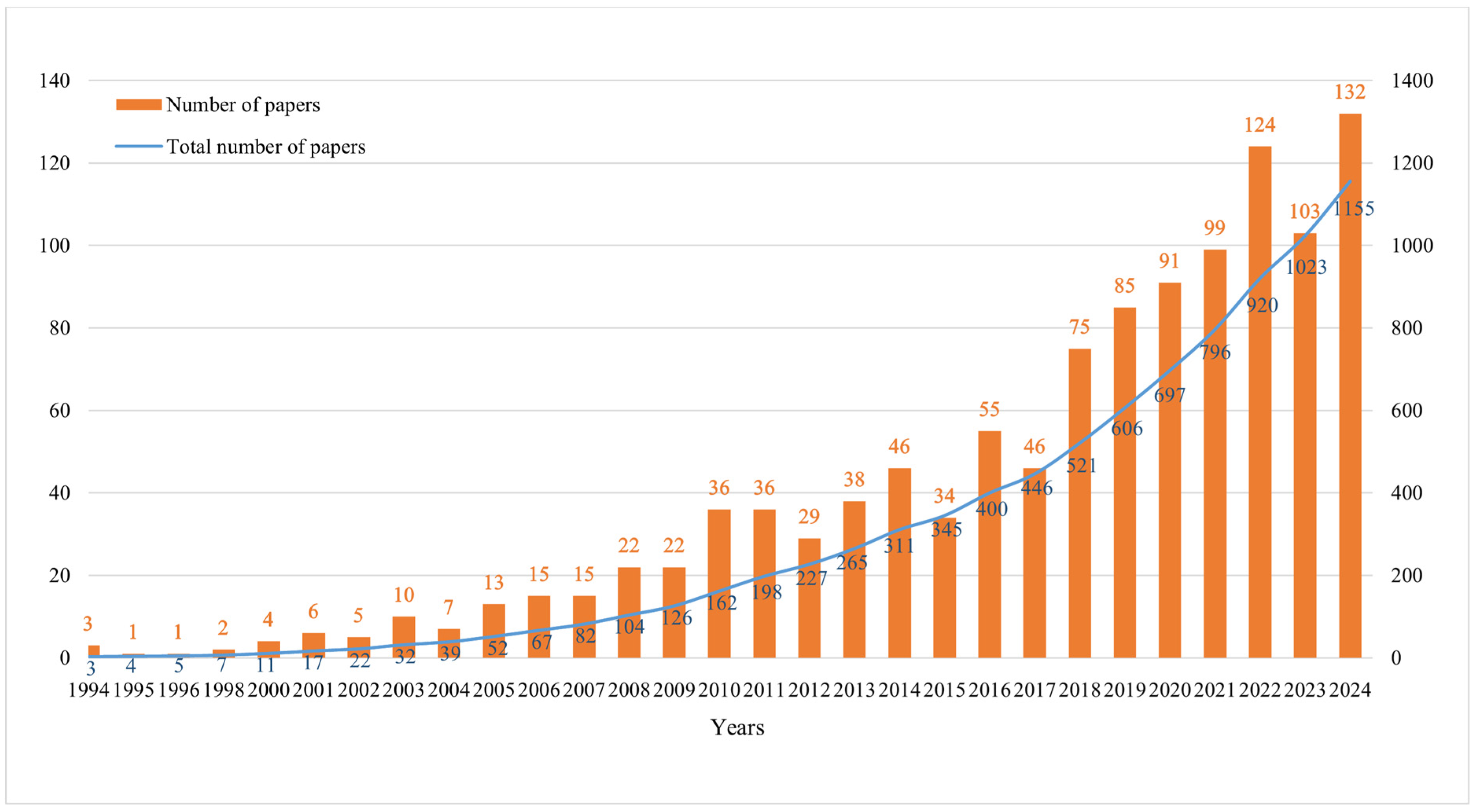
3.1. Publications and Annual Growth

Figure 1 delineates three distinct phases in the evolution of PFRS research, quantified through the bibliometric analysis of 1155 publications (1994–2024):
The first phase was Nascent Exploration (1994–2000): Annual publications averaged <5 papers, reflecting the field’s emergent status. The foundational work during this period focused on validating remote sensing’s utility for fire impact assessment. Note Bourgeau-Chavez et al.’s pioneering use of ERS-1 SAR to map burn severity in Alaskan boreal forests, demonstrating synthetic aperture radar’s sensitivity to post-fire structural changes [21]. In the same year, Elizabeth et al. proposed using remote sensing technology to identify two major structural differences between forest types, old growth and young post-fire stands, thus advancing the conservation of pristine woodlands [22]. In this phase, PFRS research is unfolding, constrained by a limited sensor resolution (<60 m) and manual image processing workflows.
The second phase was Methodological Expansion (2001–2017): There was a more notable increase in publications; particularly between 2005 and 2010, the number rapidly rose from about ten papers annually to thirty or forty. This growth was closely related to the widespread application of remote sensing data sources (such as Landsat, MODIS) and fire assessment indices (such as NBR, dNBR) in research [23,24]. Subsequently, the publication volume continued to climb in the mid-to-late 2010s, with some years approaching or exceeding 50 papers. During this period, researchers progressed from traditional medium to low-resolution imagery towards multi-source data fusion (hyperspectral, SAR, LiDAR, etc.) and dived into more complex ecological modeling [25,26].
The third phase is Technological Convergence (2018–2024): Notably, the field entered a hypergrowth phase, gradually approaching or exceeding 100 papers annually between 2019–2024, showing an accelerating upward trend. This phenomenon correlates with the increasing frequency and intensity of global fires and growing public concern about fire risks and ecological losses [27]. It also benefits from the rise of big data and artificial intelligence technologies, enabling researchers to utilize richer remote sensing data. Google Earth Engine (GEE) has been extensively used for various applications, including wildfire mapping and trend analysis, due to its key advanced characteristics, such as being free to use, providing high-speed parallel processing without downloading data, and being user-friendly [28]. Parks and his team present methods to quickly and easily produce Landsat-derived fire severity metrics (dNBR, RdNBR, and RBR) within GEE and provide an expanded potential in terms of fire severity monitoring and research. The GEE-based severity datasets generally achieved higher validation statistics in terms of correspondence to field data and overall classification accuracy [29]. Overall, this publication trend clearly reflects the field’s evolution from the early slow exploratory stage to today’s multidisciplinary focus and explosive growth, suggesting that post-fire remote sensing research will maintain a high vitality and attract more investment from scientific communities and management departments in the coming period.

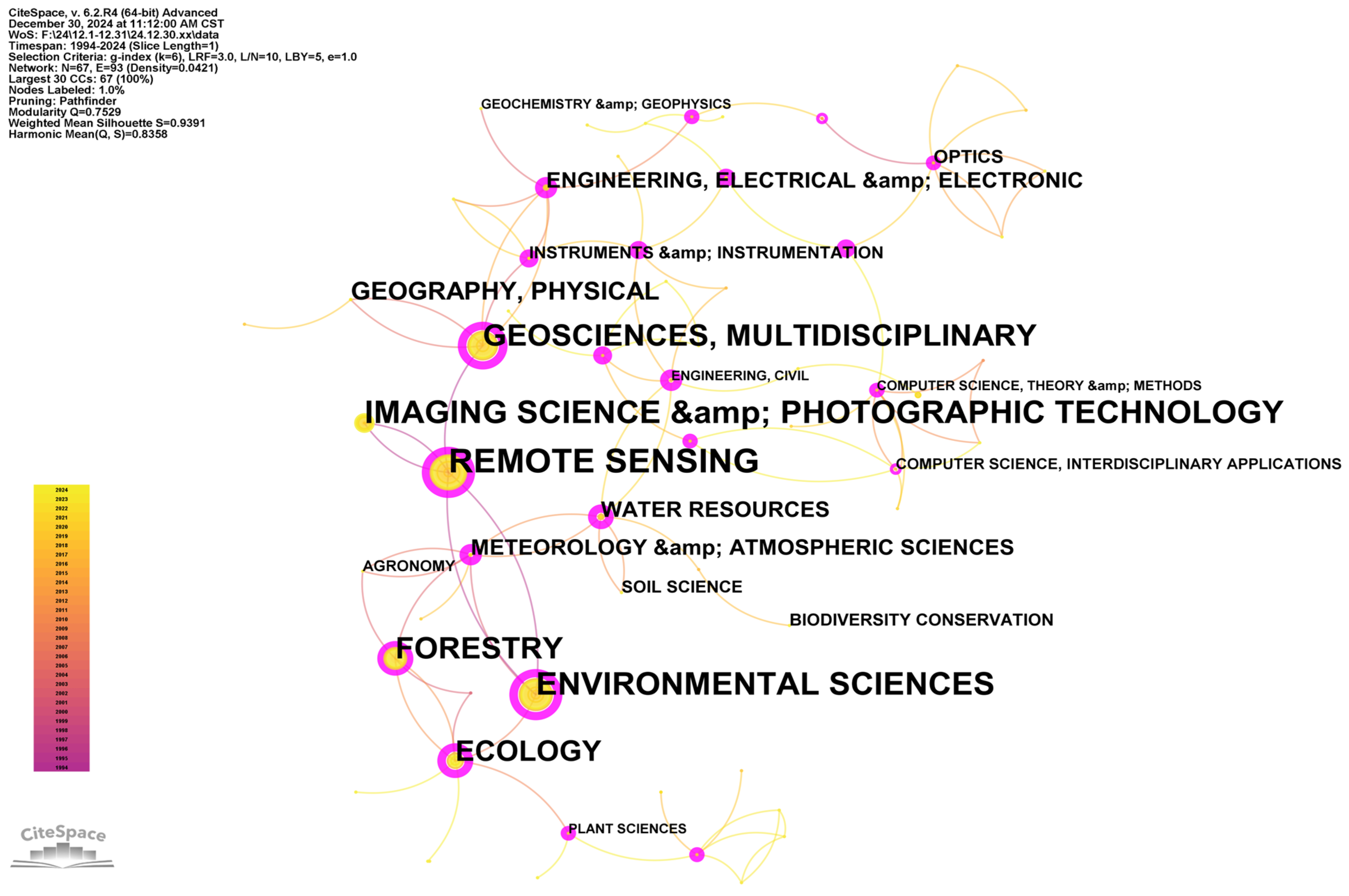
3.2. Subject Area Distribution

The visualization based on subject categories shows the distribution and intersection of literature in different research fields within the “post-fire remote sensing” theme (Figure 2). From the figure, we can observe that the subject categories include both technical and natural science branches centered on “remote sensing”, “photogrammetry”, and “geosciences” as well as fields that assess the ecological impact of wildfires at macro and micro levels, such as “environmental sciences”, “ecology”, “meteorology”, and “hydrology”. It even extends to directions like “optics” and “computer science” that provide critical technical support for related data collection and processing.
The dense connections between central nodes such as “REMOTE SENSING”; “GEOSCIENCES, MULTIDISCIPLINARY”; “ENVIRONMENTAL SCIENCES”, and “ECOLOGY” reflect the bridging role of remote sensing methods in multidisciplinary comprehensive research (Figure 2): on the one hand, characterizing post-fire surface and atmospheric processes from a geoscience perspective and on the other hand, incorporating the needs of environmental science, ecology, forestry, and other subdivided disciplines for ecosystem health assessments and management strategy formulations after fires. Additionally, the prominent connection between “IMAGING SCIENCE AND PHOTOGRAPHIC TECHNOLOGY” and “COMPUTER SCIENCE, INTERDISCIPLINARY APPLICATIONS” highlights the important position of technical platforms and algorithms in this field, especially as new approaches like big data, ML, and hyperspectral/multispectral imaging continue to push the boundaries of research depth and breadth. It shows that studies concerning fires and their aftermath are no longer restricted to isolated forestry or ecology spheres but instead integrate fields including engineering, geography, meteorology, environmental science, and information technology. It establishes a three-dimensional research network with remote sensing as the bridge, ecology and environment as the core, and collaboration with engineering and computer science as its foundation.
From Table 2, “REMOTE SENSING” (with a frequency of 492) holds the most central position, with a relatively high centrality (0.36), confirming the crucial role of remote sensing technology in post-fire recovery research. “ENVIRONMENTAL SCIENCES” (frequency 387), “IMAGING SCIENCE AND PHOTOGRAPHIC TECHNOLOGY” (frequency 303), and “GEOSCIENCES, MULTIDISCIPLINARY” (frequency 310) follow closely, demonstrating the continued intersection and deep integration of environmental science with geoscience and imaging science in this field. The asymmetric centrality scores (environmental sciences > remote sensing) suggest environmental applications drive technological innovation rather than vice versa. Meanwhile, traditional ecology- and environment-related disciplines such as “FORESTRY”, “ECOLOGY”, “METEOROLOGY AND ATMOSPHERIC SCIENCES”, and “WATER RESOURCES” maintain a high literature output, indicating researchers’ sustained attention to multiple ecosystem processes post-fire. Water resources (56 frequency, 0.53 centrality) emerged post-2005 as a critical subdomain, correlating with studies linking post-fire hydrological cycles to vegetation recovery rates [30].
Notably, newly emerging or low-frequency but relatively recent subject categories, such as “ENGINEERING, AEROSPACE” (2009), “COMPUTER SCIENCE, ARTIFICIAL INTELLIGENCE” (2011), “ROBOTICS” (2023), and “ENGINEERING, OCEAN” (2022), reflect the field’s continuous expansion into emerging technological directions. On the one hand, developments in aerospace and robotics technology have provided more possibilities for remote sensing data acquisition and post-fire monitoring; on the other hand, artificial intelligence algorithms are increasingly becoming important tools for fire detection and subsequent ecological recovery process simulation [31]. Furthermore, the emergence of disciplines such as “BIODIVERSITY CONSERVATION” (2010), “SUSTAINABLE SCIENCE AND TECHNOLOGY” (2019), and “URBAN STUDIES” (2023) indicates that post-fire research topics are gradually encompassing broader social–environmental issues such as biodiversity conservation, sustainable development, and urban ecological resilience [32].

3.3. Core Journals and Literature
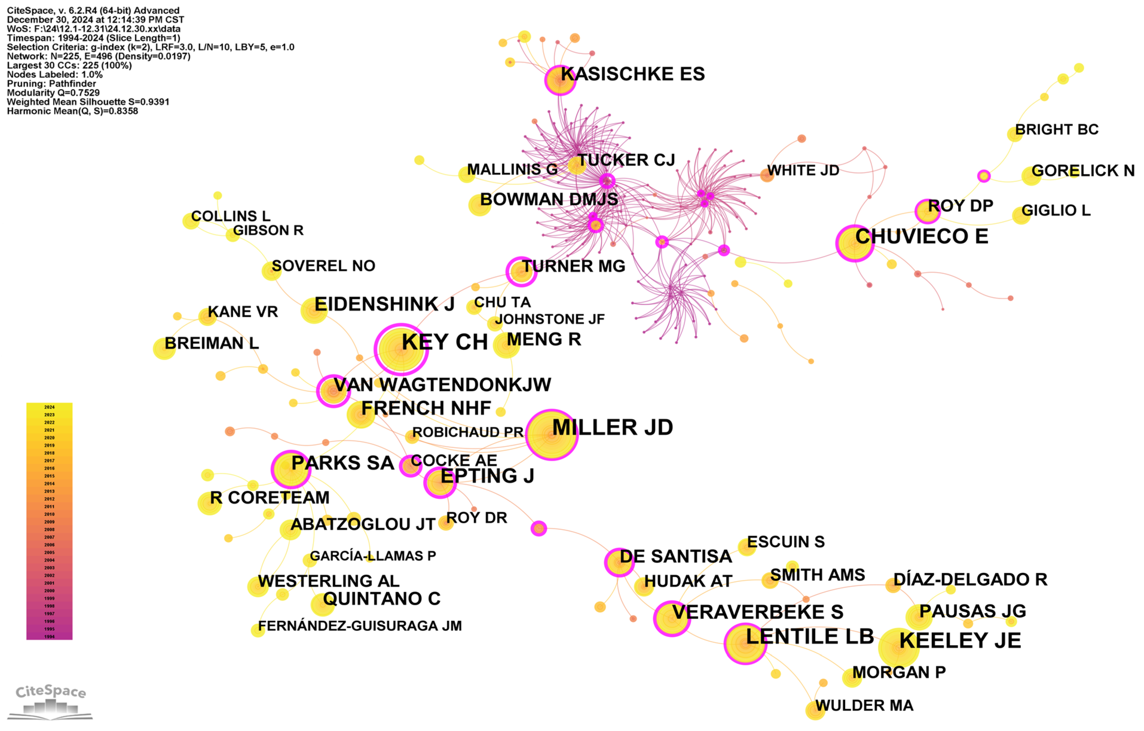
Figure 3 shows the journals with at least 200 citations. From the journal co-citation diagram, it is apparent that certain leading journals in remote sensing and ecological/environmental studies (such as Remote Sensing of Environment, International Journal of Remote Sensing, Forest Ecology and Management, International Journal of Wildland Fire) show sizeable nodes and dense interconnections, occupying the network’s central position, indicating their substantial citation impact and broad reach in the sphere of “post-fire remote sensing”. These publications largely integrate theoretical and practical research, spanning remote sensing data analysis, wildfire surveillance, and the study of ecological recovery processes. Hence, whether introducing novel techniques, undertaking case investigations, or providing reviews, they often attract co-references from other scholars. Concurrently, ecological and climate-focused journals like Ecology, Ecosystems, Global Change Biology, and Climatic Change occupy prominent places in the network, indicating that post-fire recovery extends beyond mere technology or monitoring and intersects deeply with ecology and global change research. Similarly, engineering-focused publications like IEEE Transactions on Geoscience and Remote Sensing and the ISPRS Journal of Photogrammetry and Remote Sensing present advanced remote sensing and image analysis methods, delivering essential backing for fire severity assessment and subsequent fire-related monitoring.
The core journals generally center on remote sensing and ecological/environmental themes, incorporating research outcomes from the engineering and climate change domains, mirroring the interdisciplinary character of post-fire studies. Overall, these key journals collectively form a knowledge network focused on a remote sensing–ecology crossover, while also embracing climate and environmental perspectives.
Reference co-citation analysis brings to light how different publications interrelate, facilitating an in-depth understanding of disciplinary frameworks, pinpointing the key literature and basic research underpinnings, and uncovering leading trends and frontiers [33]. Literature with a high citation count tends to have strong scholarly significance and play a leading role. Running CiteSpace produced Figure 4, in which each node is a distinct cited publication, and those with over 15 citations are annotated with the first author and the year of publication. Additionally, links signify co-citation relationships among the documents. A bigger node indicates a more critical reference; the shorter the distance between two nodes, the higher their co-citation rate and the greater the similarity in their research topics [34,35]. The network exhibits a left-to-right chronological structuring, with foundational spectral indices (left) feeding into ML-driven approaches (center), which subsequently enable climate-adaptive frameworks (right). This progression mirrors the field’s shift from descriptive mapping to predictive analytics. Among these, the paper by Gibson R et al. titled “A remote sensing approach to mapping fire severity in South-Eastern Australia using Sentinel-2 and Random Forest” stands out as the most frequently co-cited article. It indicates that employing Sentinel-2 imagery and Random Forest (RF) supervised classification allows for highly accurate fire severity mapping, underscoring the importance of integrating multiple automated systems to achieve a more comprehensive remote sensing fire-mapping solution [36].
Among the top 10 most cited articles, four are recent research articles published within the past five years. Of these four, three employ remote sensing spectral indices (e.g., dNBR), highlighting their utility in assessing fire severity. Two use ML techniques (e.g., RF), illustrating their advantages in multifactorial, complex contexts. All articles rely on Landsat or Sentinel-2 data, emphasizing the significance of high-resolution imagery for enhancing classification accuracy [10,36,37,38]. Additionally, nodes with a purple ring in Figure 4 indicate a document centrality exceeding 0.1. A broader purple ring implies a more pivotal role for that node. A 2018 study by Collins L et al. examined the potential of RF algorithms for fire severity classification and mapping, demonstrating the promise of ML in classifying fire severity across heterogeneous landscapes [39]. Among the selected literature, this research exhibits the highest centrality (0.46). Its corresponding node occupies a hub position in the co-citation network, linking numerous papers from the past five years. This underscores its foundational role in shaping further investigations into “ML and post-fire remote sensing”, through key metrics, data products, or theoretical frameworks. These observations also corroborate the earlier argument that research interests are veering towards more refined and integrative strategies, including ML-based fire monitoring and large-scale analyses on cloud computing platforms.

3.4. Core Authors

Core author analysis generally covers two dimensions: the co-author analysis, showing direct collaboration among authors (Figure 5), and the author co-citation analysis, highlighting the frequency and degree of association by which these authors are co-cited (Figure 6). The dual-network analysis of author collaboration and co-citation patterns reveals distinct yet complementary dimensions of knowledge production in PFRS research. The first dimension reveals how research teams or individual academics band together within a given area, whereas the second underscores a scholar’s foundational role in the field’s knowledge framework and their impact on later research (10.1517/21678707.2014.920251; 10.1016/j.est.2021.102253). Combining both types of visualizations enables a more holistic understanding of how author groups and academic networks interrelate in the current post-fire remote sensing arena.
Author collaboration play a crucial role in knowledge exchange, innovation, and the advancement in research quality within the post-fire remote sensing field. Drawing on the WOS Core Collection, 3883 authors were identified and subjected to co-authorship analysis. In the author collaboration network (Figure 5), early notable collaborative clusters revolve around scholars such as Kasischke, ES; French, NHF; and Bourgeauchavez, LL. In contrast, more recent co-authors such as Quintano, Carmen and Calvo, Leonor form close clusters with Fernandez-Garcia, Victor, Suarez-Seoane, Susana, and Fernandez-Guisiraga, Jose Manuel, indicating that they have published collaboratively on a frequent basis in post-fire remote sensing research and driven progress in the field together.
Figure 5 also reveals several relatively independent or smaller-scale author networks, mainly in the form of small groups with 2–5 members. For instance, Liu, Shuguang, Huang Shengli, and Dahal Devendra have worked on surface changes in the Alaskan region triggered by wildfires and secondary succession [40]. The Canadian team of Coops, Nicholas C; White, Joanne C; and Wulder, Michael A focuses on evaluating shifts in forest structure along productivity gradients in Northern Canada following wildfires, using diverse remote sensing datasets [41]. Additionally, there is a considerable number of relatively autonomous authors who have not formed explicit networks with others, indicating limited communication and collaboration—such as Gimeno, M and Hanan, Erin J. The lack of interaction and communication among international peers has, to some extent, hindered the generation and advancement of ideas in this field.
In contrast, the author co-citation network (Figure 6) unveils those scholars who serve as “cornerstone” or “link” figures within the conceptual and methodological frameworks of the academic field. Among them, Miller, JD (407) and Key, CH (395) have the highest citation counts, occupying the largest nodes, with Key, CH also exhibiting the highest centrality (0.9). Miller, JD’s research primarily centers on wildfire impacts on forest ecosystems, fire severity evaluation, and post-wildfire ecological restoration, rather than engaging in more interdisciplinary topics leading to the phenomenon. More specifically, Miller, JD and his team proposed the relativized dNBR (RdNBR) for standardizing fire severity assessments [42], and they investigated the long-term effects of fires on diverse forest types, thereby evaluating the duration and patterns of post-fire vegetation recovery [43].
Meanwhile, Key, CH and his team developed FIREMON, a standardized framework for post-wildfire evaluation [44]; they also proposed and tested approaches to gauge wildfire landscape heterogeneity, highlighting the significance of unburnt zones in aiding the restoration of plants [45]. Their work is broadly referenced in fire ecology, remote sensing, and climate change research, which explains their high citation counts and high centrality. He is not only a central scholar in the field of wildfire ecology but also a key facilitator of disciplinary integration and knowledge dissemination, providing significant support for global fire monitoring and post-fire recovery research. The co-citation network does not precisely overlap with the author collaboration network. Some authors who appear relatively “independent” in the collaboration network may have prominent node positions in the co-citation map due to pioneering work or highly cited publications, and vice versa.

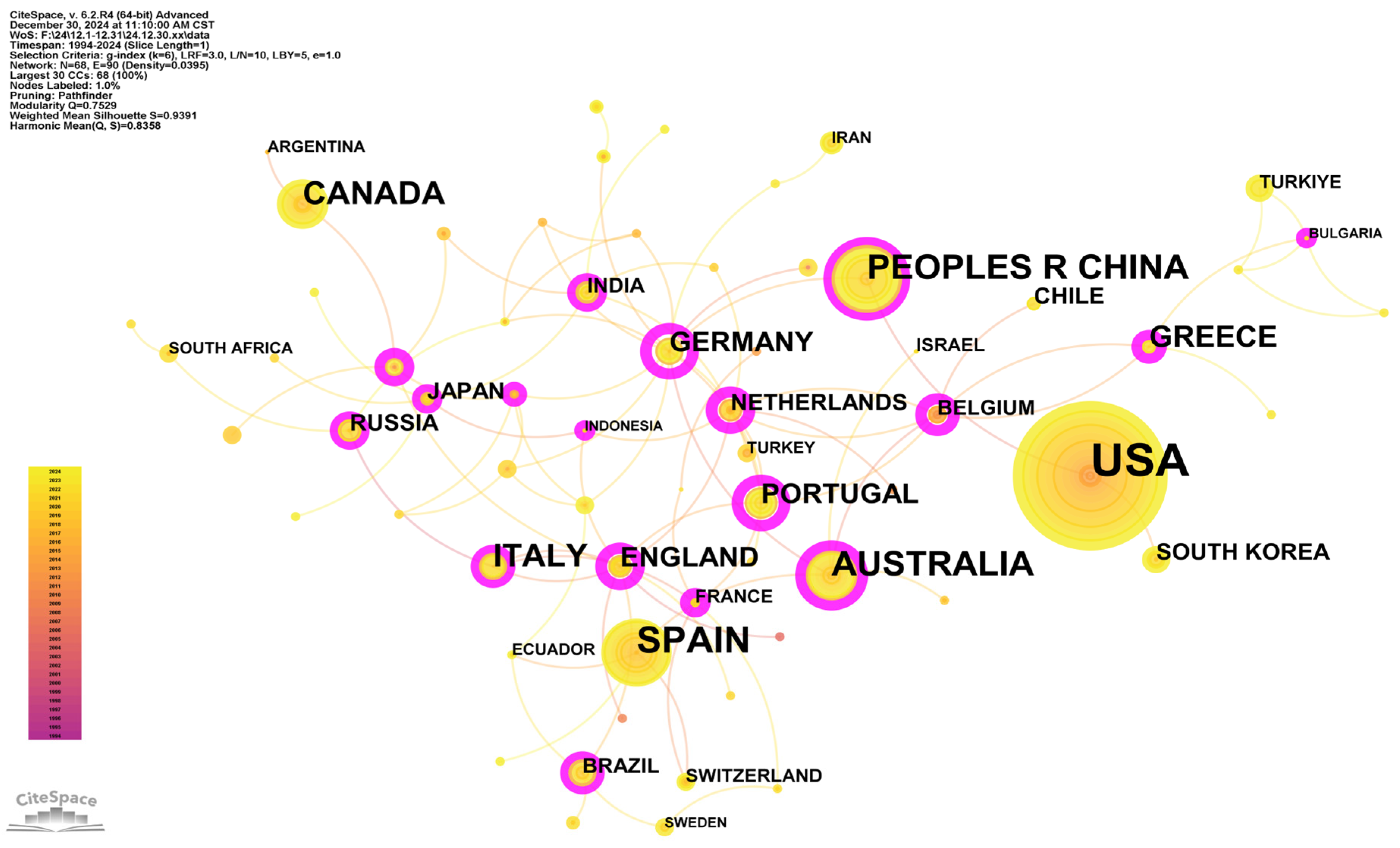
3.5. Countries and Institutions
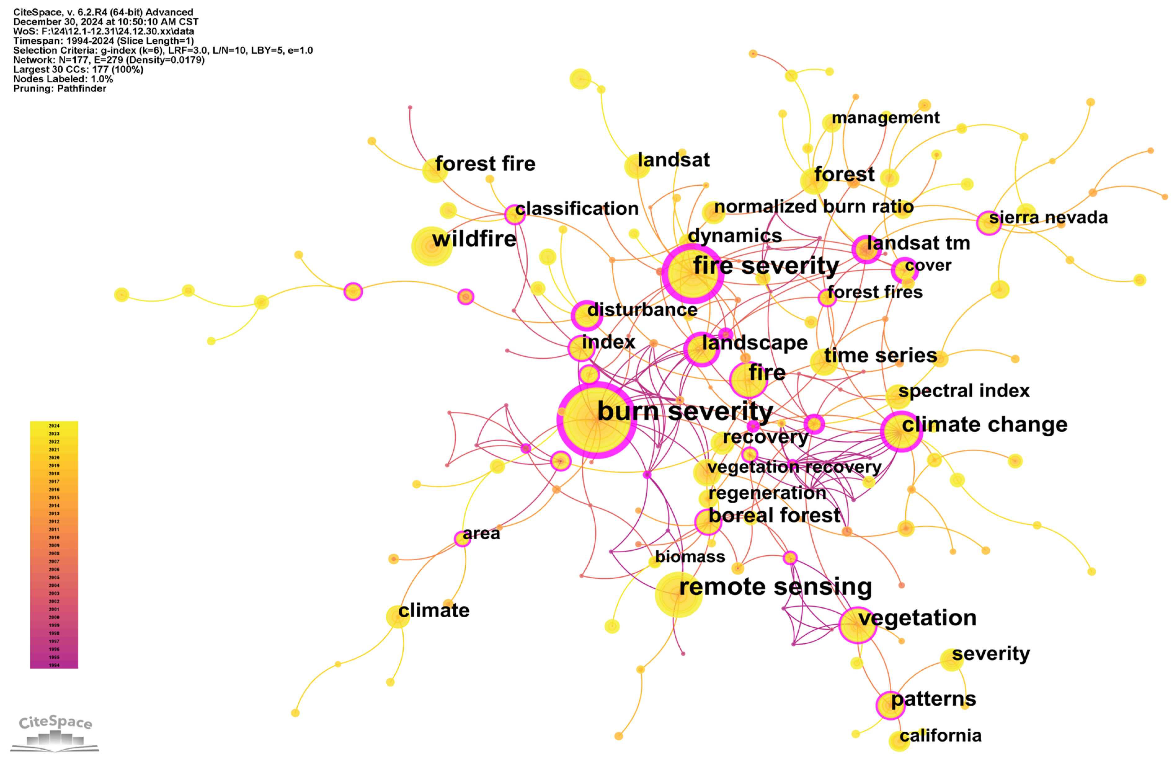
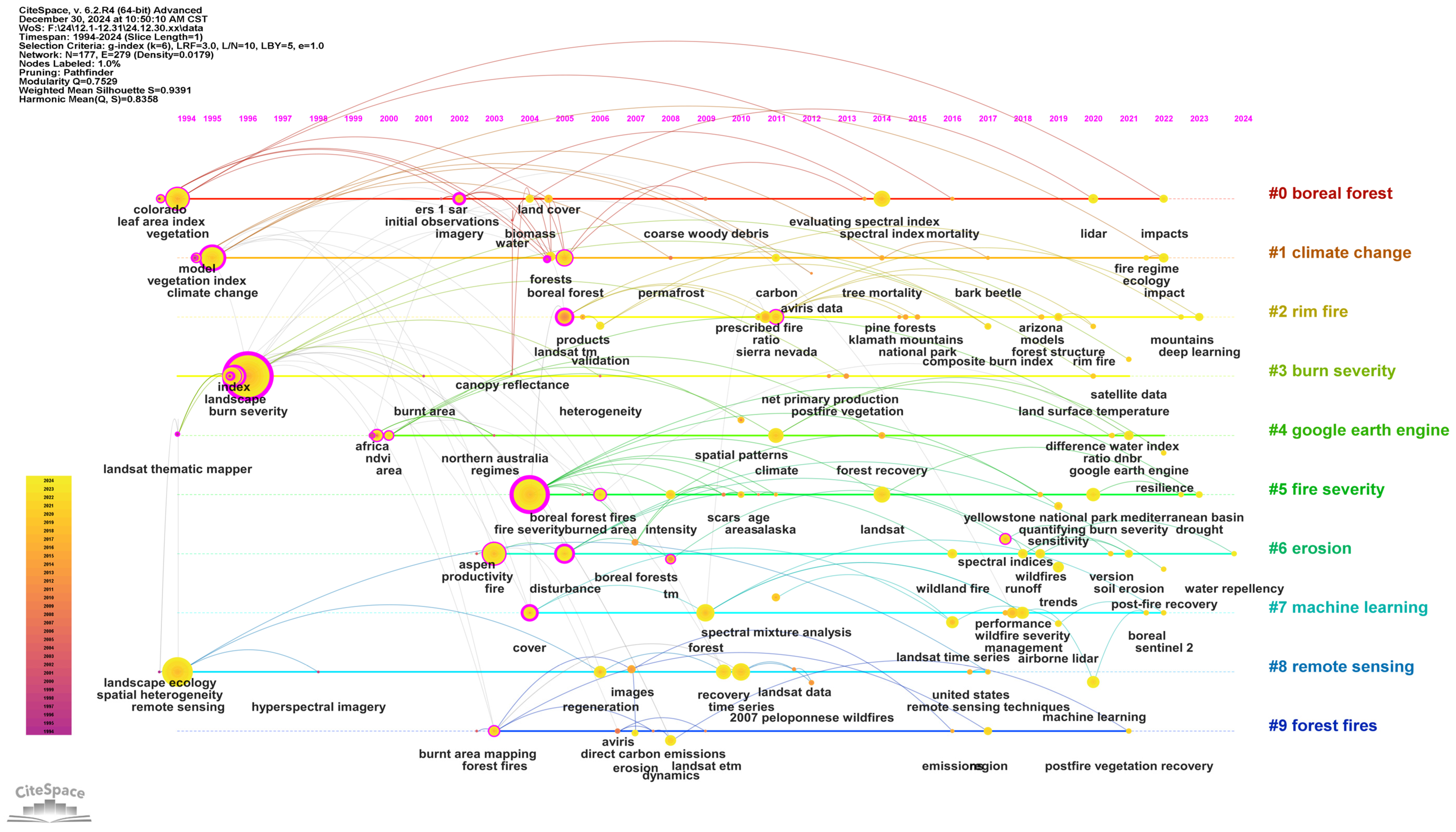
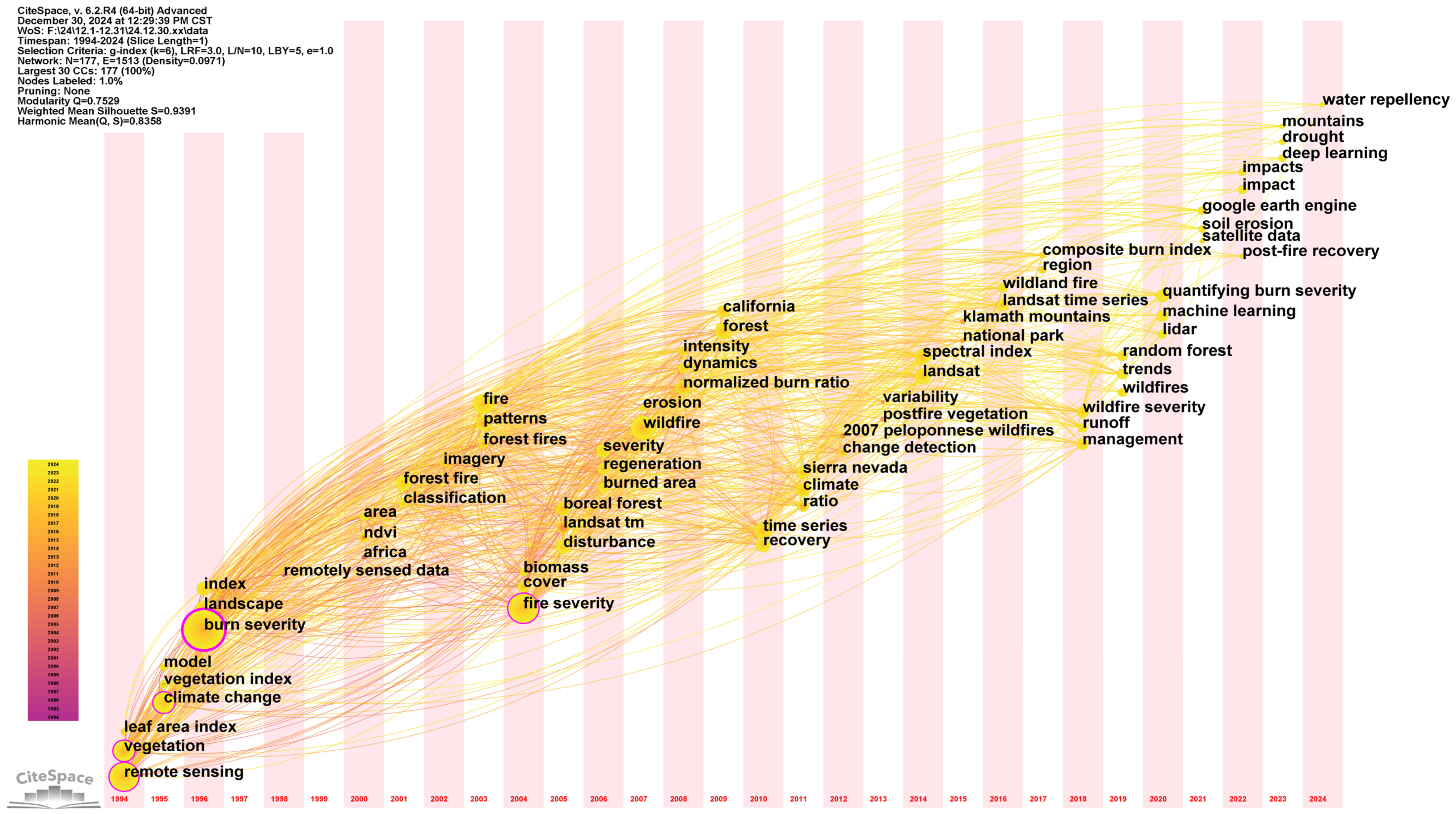
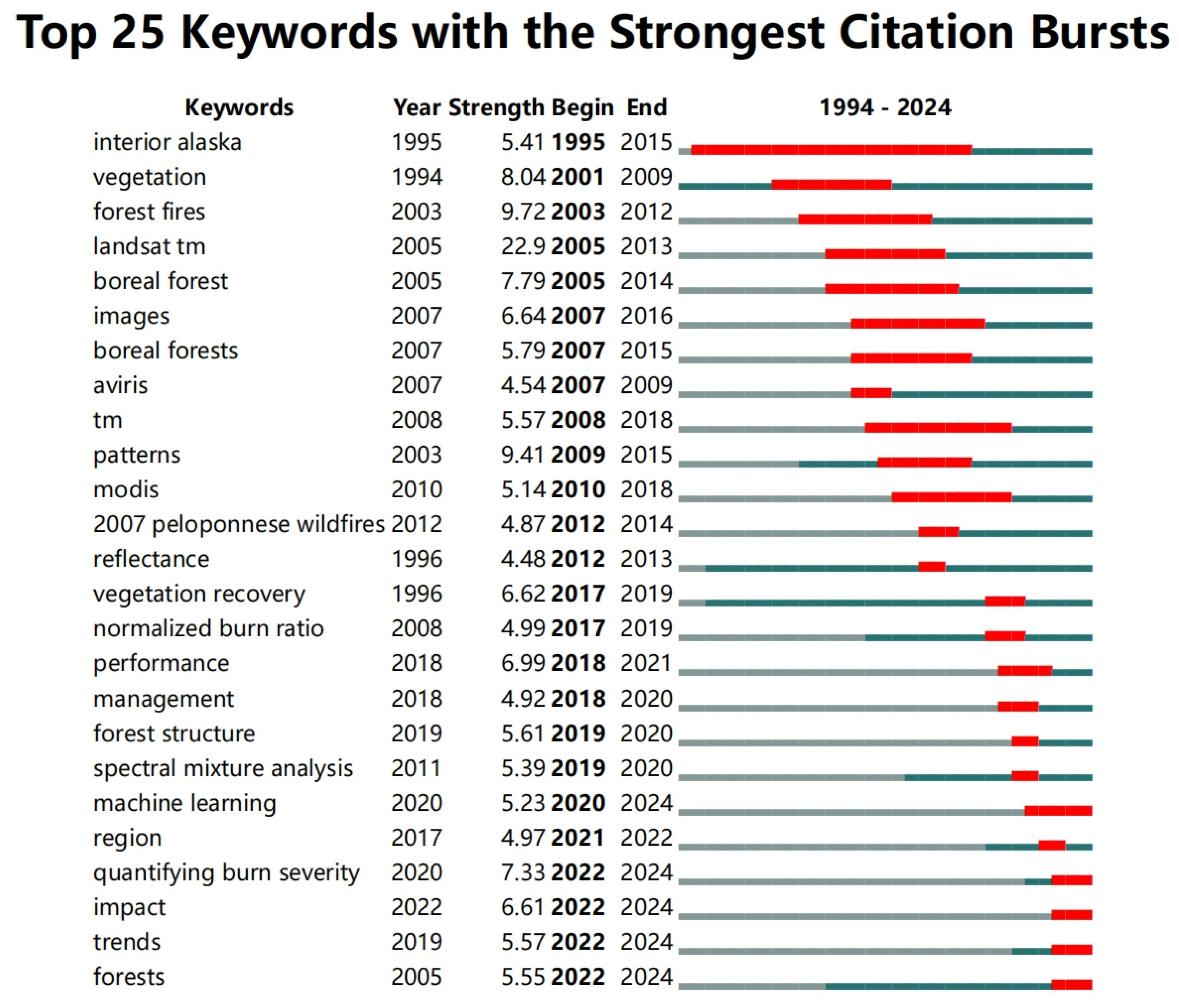
In the country/region co-occurrence map (Figure 7), the USA and the People’s Republic of China (PRC) occupy larger node sizes, indicating that both nations produce a notable volume of publications in post-fire remote sensing research. Spain, Australia, and Canada also feature prominent nodes, maintaining broad academic ties with numerous neighboring countries. While the USA dominates in publication volume, European institutions have a higher citation impact. Within Europe, multiple countries form clustered networks in the diagram; for example, Germany, the Netherlands, Portugal, Greece, and Italy are interwoven, with dense interlinkages to other nations, reflecting the prevalence of cross-border research within the EU, such as the EU Green Deal that provides the political framework to facilitate an integrated approach to wildfire risk reduction [46]. Some South American, African, and Asian countries such as Brazil, South Africa, Argentina, and South Korea display smaller nodes but still maintain some linkages with North American and European nations, indicating a multipolar global interest in forest fires and ecological restoration. Compared to countries and regions such as the United States, Australia, and Europe, Africa has been experiencing the extensive burning of forests, savannahs, grasslands, and agricultural lands, accounting for 72% of the global area burned in the last few decades and contributing more than half of the global biomass burning [47]. However, very few African institutions are conducting relevant research and collaborating with researchers from other regions. Although there is currently some wildfire and burned area assessment modeling at the watershed and ecoregion scales for specific regions in Africa, further research is needed for application to the entire continent [48].
In the institutional collaboration network (Figure 8), American governmental agencies and research institutions are clustered in the center, including the United States Department of Agriculture (USDA), the United States Forest Service, the United States Geological Survey (USGS), and the United States Department of the Interior. Surrounding them are entities such as NASA (including the NASA Goddard Space Flight Center and Jet Propulsion Laboratory), the California State University System, the University of California System, the University of Montana, and Oregon State University. This distribution pattern suggests that in the United States, post-fire remote sensing research is frequently advanced through collaboration among government agencies, NASA and other aerospace institutions, universities, and research centers.
Mirroring the US context, Canadian institutions such as Natural Resources Canada, the Canadian Forest Service, and the University of British Columbia also collaborate frequently with certain American and European universities and research centers, aligning with the necessity for high-latitude forest ecology research and fire surveillance [49]. Within Europe, Spain’s Universidad de Leon, Universidad de Valladolid, and the Consejo Superior de Investigaciones Científicas (CSIC) jointly undertake studies on post-fire remote sensing, while Italy’s Consiglio Nazionale delle Ricerche (CNR) and Belgium’s Ghent University link up with multiple universities and research institutes in Figure 8. In addition, the Chinese Academy of Sciences (CAS) has demonstrated active collaboration with US organizations such as the USDA, aligning with China’s growing emphasis on forest and ecological recovery research in recent years (10.3390/rs5126938). Overall, cooperation at both national and institutional levels strongly supports the growing trend of international collaboration in post-fire remote sensing research. By integrating diverse disciplines, this multi-tier collaborative network drives advancements in theoretical frameworks, methodological approaches, and practical management, culminating in the formation of a cross-national and cross-sector research consortium.

3.6. Keywords

Examining the frequency and interconnections of these co-occurring keywords helps identify key topics within a given research domain [50]. From the keyword co-occurrence map (Figure 9), it is evident that fire-related themes (e.g., fire severity, burn severity, forest fires, wildfire) and remote sensing topics (remote sensing, Landsat TM, spectral index) together form the network’s core. Among these, burn severity and fire severity exhibit large node sizes and dense linkages, underscoring their pivotal status in post-fire remote sensing research. Next in line are climate change, boreal forest, and vegetation recovery, all interconnected with post-fire ecological recovery. It indicates that researchers have moved beyond merely examining fire occurrence and intensity, now situating post-fire within the broader contexts of climate change and specific forest ecosystems, while also extending this to vegetation dynamics, ecosystem recovery, and management strategies [51,52].
To clarify how various keywords relate in these studies, a keyword clustering analysis was conducted in CiteSpace, yielding a keyword co-occurrence clustering diagram. The smaller the number following “#”, the larger the number of keywords in that cluster and the better its clustering performance [14]. As shown in Figure 10, the WOS keyword clusters include the following: #0 “boreal forest”; #1 “climate change”; #2 “rim fire”; #3 “burn severity”; #4 “Google Earth Engine”; #5 “fire severity”; #6 “erosion”; #7 “machine learning”; #8 “remote sensing”; #9 “forest fires”. These clusters may be roughly grouped into four categories:
(1)
Forest types and wildfires: “boreal forest”, “rim fire”, and “forest fires”. Much post-fire remote sensing research focuses on specific regions or well-known wildfire events [53,54]. Boreal forests are primarily located in the high latitudes of the Northern Hemisphere, characterized by significant carbon stocks and prominent permafrost features. Consequently, fires in these regions can profoundly affect regional and even global carbon cycles [55]. “Forest fires” refers to wildfire disturbances across diverse forest ecosystems. As climate change and human activities intensify, the extent and frequency of forest fires continue to rise, prompting widespread concern [56];
(2)
Technical support: “remote sensing”, “Google Earth Engine”, “machine learning”. This category direct reflects the rapid evolution in data and methods of post-fire research in recent years, emphasizing the new opportunities that the era of big data brings to post-fire remote sensing. Compared with conventional threshold-based or linear regression methods, ML can exploit multi-source data features more comprehensively, facilitating a more accurate prediction and spatiotemporal modeling of post-fire recovery or fire dynamics. It also captures the complexity of ecological regeneration under multiple disturbance scenarios more effectively, thus attracting significant interest [57,58];
(3)
Fire evaluation: “burn severity” and “fire severity”. This category shows the core effort in quantitatively assessing wildfire impacts in fire science, further developing multi-perspective, interdisciplinary academic discourse. Both keywords in this group concentrate on quantifying the level of destruction inflicted on vegetation, soil, and related components by fire [59]. These indicators encompass more than just the extent of burned area, instead focusing on a comprehensive quantitative appraisal of ecosystem function and structure (e.g., canopy damage, soil nutrient depletion, sur-face hydrological alterations) [60]. Consequently, the research pathway of fire assessment indicators extends naturally into post-fire forest restoration management, climate adaptation strategies, and the maintenance and rehabilitation of ecosystem services [61];
(4)
Fire and ecosystems: “climate change” and “erosion”. With global warming and an increase in extreme weather events, the frequency and intensity of wildfires generally escalate, leaving post-fire recovery to contend with a more uncertain climatic background [62]. Following a wildfire, vegetation cover declines abruptly and soil structure deteriorates; combined with intense rainfall or snowmelt, this can trigger severe soil erosion and the loss of soil resources. The decline in soil carbon and nutrients not only prevents subsequent vegetation regeneration but may also compound sediment build-up in water bodies, thus degrading their water quality [63]. Evidently, fire ecology research is increasingly underscoring the multi-medium interplay of “fire–water–soil–atmosphere”, prompting a convergence of hydrology, geomorphology, ecology, and various other fields.
These four main thematic categories intertwine to build a multidimensional framework for post-fire remote sensing research: “Starting from specific forest types and fire scenarios, making use of evolving remote sensing and big data methods, employing proven or newly developed indicators to quantify fire impacts, and incorporating climatic and environmental perspectives to comprehensively elucidate the drivers and recovery mechanisms of post-fire ecosystems”. Throughout this process, post-fire remote sensing research exhibits a strong interdisciplinary character and is deeply integrated with global environmental change topics, offering vital scientific support for scholars, administrators, and government bodies in managing wildfire risks, driving restoration, and ensuring ecological security.
By identifying burst keywords, a timeline visualization is generated. When a set of keywords from the same cluster appear horizontally aligned, it indicates a prolonged temporal span, suggesting that the cluster emerged earlier in the study and maintained its relevance over an extended period. In general, post-fire remote sensing research clusters exhibit close interlinkages, with considerable cross-disciplinary inquiry. In the early phase, around 1994–2000, traditional remote sensing indices (e.g., NDVI, leaf area index) and broad concepts such as climate change and vegetation came into focus. Subsequently, between 2000 and 2010, terms like canopy reflectance, fire severity, boreal forest, climate, and forest fires emerged as hot topics, suggesting a rapidly evolving framework of “assessing fire intensity via remote sensing indicators within a regional or global environmental change context, and analyzing structural and functional changes in post-fire ecosystems”. After 2010, emerging technologies such as ML, GEE, and lidar became increasingly salient, demonstrating a trend towards leveraging big data and high-resolution datasets for the finer-scale characterization of post-fire recovery and ecological processes (Figure 11).
In the keyword time zone diagram (Figure 12), research topics exhibit distinct priorities of focus during different periods. Early work concentrated on fundamental issues such as wildfire remote sensing, vegetation indices (e.g., NDVI, LAI), and climate change. With the dive into post-fire remote sensing, investigations into mid-level themes and mechanisms, including fire severity, burn severity, and boreal forests, became increasingly active. In recent years, machine learning, RF, and deep learning techniques have been applied to construct and forecast multi-dimensional, multi-scale models of post-fire ecological recovery. Meanwhile, additional studies target secondary post-fire effects such as soil erosion and water repellency [64], along with the potential of large-scale, long-duration analyses using cloud computing platforms like GEE. The time zone view illustrates how the field has rapidly moved from mere post-fire remote sensing surveillance to dynamic prediction, precise management, and multi-source data integration [65,66].
A “keyword burst” refers to a term whose frequency abruptly increases in a short period, helping to reveal trends and changes in keyword frequency within a specific timeframe and, through their burst intensity and duration, identify influential topics in the field. The keywords are ranked by burst intensity, and the top 25 are visualized (Figure 13). In this figure, “Begin” indicates the first year of the burst, “End” indicates its concluding year, red highlights the burst period, and blue denotes the yearly timeline. In Figure 13, it is apparent that research hotspots surface in different years and remain active for a span before eventually waning or persisting, further illustrating and validating the scholarly evolution outlined earlier. Keywords such as “interior Alaska” (1995–2015), “vegetation” (2001–2009), and “forest fires” (2003–2012) garnered strong early attention, indicating that initial research interest focused on post-fire ecology in particular regions, vegetation response, and large-scale forest fire surveillance. The prominence of Alaska and boreal forests primarily increased from the early 2000s to around 2010, aligning with the “focus on high-latitude forest ecosystems” described earlier in this paper.
After 2005, remote sensing keywords—such as “landsat tm”, “tm”, and “modis”—showed a clear rise in burst strength and sustained influence over extended periods; for instance, Landsat TM remained active from 2005 to 2013, while MODIS achieved high citation levels from 2010 to 2018. This timeframe aligns with the previously mentioned mainstream research approach of “using optical remote sensing imagery to evaluate fire effects and monitor post-fire recovery”, indicating that multi-source satellite data served as a major driver in post-fire studies during this phase [67]. Similarly, “patterns” and “reflectance” also exhibited significant bursts between 2009 and 2015, suggesting a peak attention to fire forms and their spectral attributes.
Notably, many recent or ongoing strong burst keywords relate to emerging technologies, comprehensive assessments, and post-fire ecological management. “Machine learning” began to surge from 2020 and was projected to continue until 2024, while “quantifying burn severity”, “impact”, “trends”, and “region” also entered a burst phase around 2022. These keywords mirror the contemporary waves of research discussed above, featuring cloud computing platforms, multi-source big data, and artificial intelligence algorithms. Moreover, “performance”, “management”, and “forest structure” spiked between 2018 and 2020, suggesting significant interest in fire management strategies, forest structure assessment, and model validation [68].
Reviewing the full timeline, the evolution of post-fire remote sensing has undergone three distinct phases: (1) late-1990s foundational studies on vegetation recovery in fire-prone regions like Alaska; (2) 2000s advancements in boreal forest monitoring using medium to high-resolution satellite data; and (3) post-2010 breakthroughs driven by artificial intelligence and big data analytics. It reflects the ongoing shift of post-fire remote sensing research from regional cases and classic methods towards globalization, refinement, and automation. The temporal distribution of these burst keywords further corroborates previous interpretations of the research network structure, clustering themes, and timeline of the post-fire remote sensing research development pipeline.
From the keyword analysis, it is evident that, in the past 30 years, this domain has moved from “using remote sensing to monitor fires and assess the impacts” to “addressing post-fire ecological recovery and governance under climate change” and most recently to “employing ML, cloud computing, and multi-sensor integration for advanced forecasting and assessment of fire activity and post-fire vegetation trends”. Throughout post-fire remote sensing research, “burn severity” and “fire severity” remain pivotal, linking tightly with forest categories (“boreal forest”, “forest fires”) and connecting to macro-level concerns (e.g., “climate change”, “erosion”, “management”). From a technical standpoint, “remote sensing”, “Google Earth Engine”, and “machine learning” form distinct modules, addressing core requirements for post-fire recovery and wildfire evaluation. The synergy of disciplines and cross-domain technological complementarity continues to generate new methods and applications. Concurrently, the network structure of these keywords indicates a growing trend of cross-disciplinary interaction and convergence, suggesting that post-fire remote sensing research will further progress towards ecological restoration, climate adaptation, and hazard management under multi-technology collaboration and multi-scale evaluation.

3.7. Basic Situation of Research in the Field of Post-Fire Remote Sensing

The bibliometric analysis of 1155 publications (1994–2024) reveals the volume of publications on post-fire remote sensing has been rising for many years, but the annual output remains relatively small (<150 papers/year), underscoring the field’s emerging status and untapped potential. While the foundational frameworks for fire impact assessment are well established, critical gaps persist in operationalizing findings for ecological governance. Investigations into post-fire recovery encompass not only the monitoring and mechanistic analysis of burn severity and fire severity but also extend to vegetation regrowth dynamics under climate change, soil erosion, hydrological processes, and biodiversity conservation [69]. Using bibliometric and visual analytics, the present investigation systematically reviews the state of post-fire remote sensing and ecological recovery research, indicating that the core topics revolve around quantifying and assessing fire events, along with tracking post-fire recovery dynamics across key global forest ecosystems. The following points need deeper investigation and a heightened focus:
From the perspective of monitoring and quantification, post-fire assessments have traditionally depended on medium- and low-resolution optical data and limited remote sensing indices. Now, with the emergence of hyperspectral, LiDAR, and SAR techniques, studies are steadily progressing towards more refined and diversified approaches. The bibliometric analysis underscores keywords like “machine learning”, “Google Earth Engine”, and “quantifying burn severity”, highlighting the potential of novel algorithms and platforms for processing high spatiotemporal resolution data and conducting fire assessments at the global scale [70]. However, challenges remain, including information redundancy and the limited generalization of the algorithms, calling for additional field verifications and cross-site comparisons to improve the reliability of the findings. Most of the current PFRS modeling has strong temporal and spatial limitations and is not able to accurately assess larger-scale areas [71].
Concerning post-fire ecological dynamics and restoration, the recent emergence of keywords like “climate change”, “forest structure”, and “vegetation recovery” shows that post-fire regeneration is now viewed within a more complex climate–ecology system, rather than scholars merely quantifying burned regions or fire severity [72]. Mechanistically, post-fire ecosystem restoration typically involves a host of intricate factors such as climate conditions, soil nutrients, water availability, and subsequent disturbances [73]. At the same time, how to deal with and assess post-fire ecology and restoration is a dynamic decision-making process [74]. Coupled analyses of these variables necessitate interdisciplinary theoretical and methodological contributions from fields such as biology, geography, environmental science, and meteorology, thereby establishing an integrated and cross-sector research framework [75].
From a managerial and practical standpoint, key governmental agencies and re-search institutions (e.g., USDA, USFS, NASA, CAS) play pivotal roles in the co-authorship network, highlighting the critical importance of inter-agency and inter-disciplinary collaboration in wildfire management and ecological recovery. Current research goes beyond assessing the short-term impact of fires, also taking into account longer-term structural and functional ecological changes and the impacts on carbon cycling, species diversity, socio-economic factors, and managerial strategies [76].

3.8. Prospects for Post-Fire Remote Sensing Research

The synthesis of bibliometric trends, technological advancements, and interdisciplinary demands reveals four transformative pathways for future research in post-fire remote sensing. These directions address the current gaps while aligning with global sustainability goals.
Long-term, multi-regional comparative studies: A focus on deciphering biome-specific recovery trajectories under climate change. For example, the results of a three-year field rainfall manipulation experiment suggest that summer rainfall can have a significant impact on Mediterranean-type scrubland recovery patterns and may have long-term effects on the community [77]. It remains essential to investigate the differences in fire disturbance and recovery patterns among varied forest types—particularly those highly sensitive to climate such as boreal forests, tropical rainforests, or Mediterranean ecosystems—using long-term observation data and cross-regional comparisons [78]. By utilizing high temporal resolution remote sensing imagery, ground-based plot data, and climate data, it is possible to examine the links between fire incidence, severity, and ecological recovery rates, revealing the spatial and temporal variability in post-fire recovery. Such insights underlie more precise ecological management strategies. At the same time, when confronted with post-fire landscapes, a focus on restoring ecosystems to their previous desired state should be avoided. Factors such as the degree of degradation and resilience of ecosystems, and the balance between conservation and human intervention, should be considered holistically [79]. Establishing standardized cross-continental datasets and addressing data gaps in underrepresented regions remain important [80].
Multi-source data fusion and AI-driven automation: A focus on achieving pixel-to-process understanding through integrated analytics. Building on optical imagery (e.g., Landsat, MODIS, Sentinel), researchers should incorporate hyperspectral, LiDAR, and SAR data to enhance the accuracy and automation of fire detection, burn severity quantification, and recovery simulation. For example, Hu et al. demonstrated a higher performance by applying a SAR image synthesis method based on Generative Adversarial Networks for burn area mapping and burn severity assessment using SAR and optical data [81]. In recent years, advances in computer vision and image-processing technologies have made fire stereo visual measurements possible, and understanding and modeling wildfire behavior through UAV stereo visual data can provide high-precision basic data for post-fire assessment [82]. Combining fire dynamics data with post-fire multi-temporal remote sensing imagery can fill the data gap between the macro scale and micro scale, and the correlation between fire behavior (e.g., direction of spread, intensity) and post-disaster ecological response (e.g., rate of vegetation restoration) can be investigated, providing a new perspective on fire ecology. As big data and cloud computing technologies proliferate and ML methods mature, fusing these diverse datasets and developing more generalized models promises even greater precision and automation in identifying wildfires, measuring burn severity, and modeling ecological recovery [83]. Utilizing high-resolution imagery, advanced sensor integration, AI-based algorithms, and geospatial cloud computing infrastructures is also critical to enhancing post-fire mapping and assessment, especially in under-represented tropical regions [7].
Expansion and validation of fire assessment indices: A focus on transitioning from spectral-based metrics to functional ecosystem indicators. Fires frequently coincide with varied disturbances, including drought, pest outbreaks, and land use changes, thus requiring evaluations of post-fire recovery and management strategies amid multifactor interactions. The comprehensive collection of relevant environmental variables is required to understand fire occurrence and risk [71]. Future studies should extend the current indices (dNBR, RdNBR, fire severity) by integrating ground measurements and environmental parameters (e.g., soil nutrients and moisture). The research shows that incorporating features such as leaf dry mass traits, leaf water potential, and water content into remote sensing image-based models can improve the overall performance of the models [84]. Indicators and evaluation methods should be refined to address ecosystem-specific recovery mechanisms and functional needs—such as biodiversity, carbon sequestration, or water conservation [85]. Remote sensing parameterization methods should be further developed in future studies to include the groundwater hydrological status in the analysis, use robust metrics for intercomparison studies, and link vegetation regeneration to hydrological models [86].
Interdisciplinary collaboration and integrated management decisions: A focus on bridging science and policy through co-designed tools. In future, collaboration among research institutes and government agencies should be strengthened in fire prediction, post-fire ecological restoration, resource allocation, and policy oversight, leading to more robust fire management and ecological adaptation strategies [87]. Simultaneously, via wide-ranging international partnerships and multiple academic perspectives, climate modeling, land-surface process modeling, and socio-economic analyses can be integrated into post-fire ecology research frameworks, enabling comprehensive assessments of fire disturbance effects on global climate change, regional resource management, and societal impacts. In addition, democratizing post-fire remote sensing capabilities requires the public deposition of ML training datasets (e.g., NASA’s FIRED database) and model weights under Open Science Mandates.

3.9. Limitations

While this study provides a comprehensive bibliometric overview, several limitations warrant consideration: (1) Database bias: A reliance on WOS may exclude critical studies from Scopus or regional databases (e.g., CNKI, SciELO), particularly in Chinese and South American contexts. Future studies integrating Scopus and CAB Abstracts could better capture the synergies of post-fire remote sensing in specific fields. (2) Language restrictions: Non-English publications (e.g., Russian boreal studies) were excluded. (3) Algorithmic generalization: Bibliometric tools like CiteSpace prioritize citation frequency over methodological rigor, potentially inflating the prominence of high-impact but context-specific studies. In addition, the collaborative relationships described in this study between different authors, institutions, and countries are articulated on the basis of co-authorship. However, these links do not necessarily imply shared funding or direct collaboration.

4. Conclusions

This study is the first global bibliometric synthesis of post-fire remote sensing research, uncovering novel insights that advance the field beyond prior region-specific reviews. The results indicate that early work largely concentrated on high-latitude forests (e.g., Alaska, Northern Canada) and Mediterranean regions, relying mainly on medium- and low-resolution optical imagery or field-based surveys. Over the past decade, a greater precision in large-scale fire detection and post-fire ecological assessments has been achieved through cloud computing platforms (e.g., GEE) and multi-source data (hyperspectral, LiDAR, radar, etc.). More generalized models should be further developed in the future to address climate change and different regions. Meanwhile, major research entities worldwide, including the USDA, NASA, CAS, and various European institutes, have actively collaborated in this field, giving rise to numerous high-impact journals such as Remote Sensing of Environment, International Journal of Remote Sensing, Forest Ecology and Management, and International Journal of Wildland Fire. However, Africa, as a wildfire-prone region, lacks indigenous research. In addition, there are still many under-represented regions that need attention. The international, interdisciplinary collaborations networks of post-fire research have not only facilitated a deeper integration of remote sensing methodologies and wildfire ecology theory but also provided vital scientific support for post-fire management decisions and ecological restoration strategies.

Author Contributions

Conceptualization, M.S. and X.Z.; methodology, X.Z. and R.J.; validation, R.J. and X.Z.; formal analysis, M.S. and X.Z.; investigation, M.S.; data curation, X.Z. writing—original draft preparation, M.S.; writing—review and editing, R.J.; visualization, M.S.; supervision, R.J.; project administration, R.J. All authors have read and agreed to the published version of the manuscript.

Funding

This research was funded by the Key R&D project of Jilin Provincial Department of Science and Technology, grant number [20200403030SF]; the National Natural Science Foundation of China (NSFC), grant number [42471093]; and the National Natural Science Foundation of China (NSFC), grant number [U24A20585].

Institutional Review Board Statement

Not applicable.

Informed Consent Statement

Not applicable.

Data Availability Statement

The original contributions presented in the study are included in the article; further inquiries can be directed to the corresponding author.

Conflicts of Interest

The authors declare no conflicts of interest.

References

  1. Loydi, A.; Funk, F.A.; García, A. Vegetation Recovery after Fire in Mountain Grasslands of Argentina. J. Mt. Sci. 2020, 17, 373–383. [Google Scholar] [CrossRef]
  2. Celis, N.; Casallas, A.; Lopez-Barrera, E.A.; Felician, M.; Marchi, M.D.; Pappalardo, S.E. Climate Change, Forest Fires, and Territorial Dynamics in the Amazon Rainforest: An Integrated Analysis for Mitigation Strategies. ISPRS Int. J. Geo-Inf. 2023, 12, 436. [Google Scholar] [CrossRef]
  3. Sintayehu, D.W. Impact of Climate Change on Biotdersity and Associated Key Ecosystem Services in Africa: A Systematic Review. Ecosyst. Health Sustain. 2018, 4, 225–239. [Google Scholar] [CrossRef]
  4. Liu, Y.; Goodrick, S.; Heilman, W. Wildland Fire Emissions, Carbon, and Climate: Wildfire–Climate Interactions. For. Ecol. Manag. 2014, 317, 80–96. [Google Scholar] [CrossRef]
  5. Abram, N.J.; Henley, B.J.; Gupta, A.S.; Lippmann, T.J.R.; Clarke, H.; Dowdy, A.J.; Sharples, J.J.; Nolan, R.H.; Zhang, T.; Wooster, M.J.; et al. Connections of Climate Change and Variability to Large and Extreme Forest Fires in Southeast Australia. Commun. Earth Environ. 2021, 2, 8. [Google Scholar] [CrossRef]
  6. Hao, B.; Xu, X.; Wu, F.; Tan, L. Long-Term Effects of Fire Severity and Climatic Factors on Post-Forest-Fire Vegetation Recovery. Forests 2022, 13, 883. [Google Scholar] [CrossRef]
  7. Kurbanov, E.; Vorobev, O.; Lezhnin, S.; Sha, J.; Wang, J.; Li, X.; Cole, J.; Dergunov, D.; Wang, Y. Remote Sensing of Forest Burnt Area, Burn Severity, and Post-Fire Recovery: A Review. Remote Sens. 2022, 14, 4714. [Google Scholar] [CrossRef]
  8. Shvetsov, E.G.; Kukavskaya, E.A.; Buryak, L.V.; Barrett, K. Assessment of Post-Fire Vegetation Recovery in Southern Siberia Using Remote Sensing Observations. Environ. Res. Lett. 2019, 14, 055001. [Google Scholar] [CrossRef]
  9. Pérez-Cabello, F.; Montorio, R.; Alves, D.B. Remote Sensing Techniques to Assess Post-Fire Vegetation Recovery. Curr. Opin. Environ. Sci. Health 2021, 21, 100251. [Google Scholar] [CrossRef]
  10. Mallinis, G.; Mitsopoulos, I.; Chrysafi, I. Evaluating and Comparing Sentinel 2A and Landsat-8 Operational Land Imager (OLI) Spectral Indices for Estimating Fire Severity in a Mediterranean Pine Ecosystem of Greece. GIScience Remote Sens. 2017, 55, 1–18. [Google Scholar] [CrossRef]
  11. Lai, R.; Oguchi, T.; Zhong, C. Evaluating Spatiotemporal Patterns of Post-Eruption Vegetation Recovery at Unzen Volcano, Japan, from Landsat Time Series. Remote Sens. 2022, 14, 5419. [Google Scholar] [CrossRef]
  12. Priya, R.S.; Vani, K. Vegetation Change Detection and Recovery Assessment Based on Post-Fire Satellite Imagery Using Deep Learning. Sci. Rep. 2024, 14, 12611. [Google Scholar] [CrossRef] [PubMed]
  13. Seydi, S.T.; Hasanlou, M.; Chanussot, J. Burnt-Net: Wildfire Burned Area Mapping with Single Post-Fire Sentinel-2 Data and Deep Learning Morphological Neural Network. Ecol. Indic. 2022, 140, 108999. [Google Scholar] [CrossRef]
  14. Yang, H.; Shao, X.; Wu, M. A Review on Ecosystem Health Research: A Visualization Based on CiteSpace. Sustainability 2019, 11, 4908. [Google Scholar] [CrossRef]
  15. Chen, C.; Song, I.-Y.; Yuan, X.; Zhang, J. The Thematic and Citation Landscape of Data and Knowledge Engineering (1985–2007). Data Knowl. Eng. 2008, 67, 234–259. [Google Scholar] [CrossRef]
  16. Zhu, Y.-D.; Shao, T.-J.; Wang, Y.-H.; Wang, R.-Y. Review and Future Trends of Soil Microplastics Research: Visual Analysis Based on Citespace. Environ. Sci. Eur. 2022, 34, 122. [Google Scholar] [CrossRef]
  17. Sun, H.; Zhang, X.; Ruan, X.; Jiang, H.; Shou, W. Mapping Compound Flooding Risks for Urban Resilience in Coastal Zones: A Comprehensive Methodological Review. Remote Sens. 2024, 16, 350. [Google Scholar] [CrossRef]
  18. Jia, F.; Sun, D.; Looi, C. Artificial Intelligence in Science Education (2013–2023): Research Trends in Ten Years. J. Sci. Educ. Technol. 2023, 33, 94–117. [Google Scholar] [CrossRef]
  19. Chen, C. Searching for Intellectual Turning Points: Progressive Knowledge Domain Visualization. Proc. Natl. Acad. Sci. USA 2004, 101, 5303–5310. [Google Scholar] [CrossRef]
  20. Chen, C.; Song, M. Visualizing a Field of Research: A Methodology of Systematic Scientometric Reviews. PLoS ONE 2019, 14, e0223994. [Google Scholar] [CrossRef]
  21. Bourgeau-Chavez, L.L.; Kasischke, E.S.; French NH, F.; Szeto, L.H.; Kherkher, C.M. Using ERS-1 SAR Imagery to Monitor Variations in Burn Severity in an Alaskan Fire-Distributed Boreal Forest Ecosystem. In Proceedings of the International Geoscience and Remote Sensing Symposium on Surface and Atmospheric Remote Sensing—Technologies, Data Analysis and Interpretation (IGARSS 94), Caltech, Pasadena, CA, USA; 1992; Volumes 1–4, pp. 243–245. [Google Scholar]
  22. Nel, E.M.; Wessman, C.A.; Veblen, T.T. Digital and Visual Analysis of Thematic Mapper Imagery for Differentiating Old Growth from Younger Spruce-Fir Stands. Remote Sens. Environ. 1994, 48, 291–301. [Google Scholar] [CrossRef]
  23. Tang, Z.; Zhang, T.; Wu, L.; Ren, S.; Cai, S. Knowledge Mapping for Fire Risk Assessment: A Scientometric Analysis Based on VOSviewer and CiteSpace. Fire 2024, 7, 23. [Google Scholar] [CrossRef]
  24. Yu, Y.; Shen, Y.; Liu, Y.; Wei, Y.; Rui, X.; Li, B. Knowledge Mapping and Trends in Research on Remote Sensing Change Detection Using CiteSpace Analysis. Earth Sci. Inform. 2022, 16, 787–801. [Google Scholar] [CrossRef]
  25. Zhang, J. Multi-Source Remote Sensing Data Fusion: Status and Trends. Int. J. Image Data Fusion 2010, 1, 5–24. [Google Scholar] [CrossRef]
  26. Wei, X.; Bai, K.; Chang, N.-B.; Gao, W. Multi-Source Hierarchical Data Fusion for High-Resolution AOD Mapping in a Forest Fire Event. Int. J. Appl. Earth Obs. Geoinf. 2021, 102, 102366. [Google Scholar] [CrossRef]
  27. Hart, S.J.; Henkelman, J.; McLoughlin, P.D.; Nielsen, S.E.; Truchon-Savard, A.; Johnstone, J.F. Examining Forest Resilience to Changing Fire Frequency in a Fire-prone Region of Boreal Forest. Glob. Change Biol. 2019, 25, 869–884. [Google Scholar] [CrossRef]
  28. Seydi, S.T.; Akhoondzadeh, M.; Amani, M.; Mahdavi, S. Wildfire Damage Assessment over Australia Using Sentinel-2 Imagery and MODIS Land Cover Product within the Google Earth Engine Cloud Platform. Remote Sens. 2021, 13, 220. [Google Scholar] [CrossRef]
  29. Parks, S.A.; Holsinger, L.M.; Voss, M.A.; Loehman, R.A.; Robinson, N.P. Mean Composite Fire Severity Metrics Computed with Google Earth Engine Offer Improved Accuracy and Expanded Mapping Potential. Remote Sens. 2018, 10, 879. [Google Scholar] [CrossRef]
  30. Kinoshita, A.M.; Hogue, T.S. Spatial and Temporal Controls on Post-Fire Hydrologic Recovery in Southern California Watersheds. CATENA 2011, 87, 240–252. [Google Scholar] [CrossRef]
  31. Boroujeni, S.P.H.; Razi, A.; Khoshdel, S.; Afghah, F.; Coen, J.L.; O’Neill, L.; Fule, P.; Watts, A.; Kokolakis, N.-M.T.; Vamvoudakis, K.G. A Comprehensive Survey of Research towards AI-Enabled Unmanned Aerial Systems in Pre-, Active-, and Post-Wildfire Management. Inf. Fusion 2024, 108, 102369. [Google Scholar] [CrossRef]
  32. McWethy, D.B.; Schoennagel, T.; Higuera, P.E.; Krawchuk, M.; Harvey, B.J.; Metcalf, E.C.; Schultz, C.; Miller, C.; Metcalf, A.L.; Buma, B.; et al. Rethinking Resilience to Wildfire. Nat. Sustain. 2019, 2, 797–804. [Google Scholar] [CrossRef]
  33. Chen, C. CiteSpace II: Detecting and Visualizing Emerging Trends and Transient Patterns in Scientific Literature. J. Am. Soc. Inf. Sci. Technol. 2006, 57, 359–377. [Google Scholar] [CrossRef]
  34. Liu, J.; Li, J.; Wang, J. In-Depth Analysis on Thermal Hazards Related Research Trends about Lithium-Ion Batteries: A Bibliometric Study. J. Energy Storage 2021, 35, 102253. [Google Scholar] [CrossRef]
  35. Chen, C.; Dubin, R.; Kim, M.C. Orphan Drugs and Rare Diseases: A Scientometric Review (2000–2014). Expert Opin. Orphan Drugs 2014, 2, 709–724. [Google Scholar] [CrossRef]
  36. Gibson, R.; Danaher, T.; Hehir, W.; Collins, L. A Remote Sensing Approach to Mapping Fire Severity in South-Eastern Australia Using Sentinel 2 and Random Forest. Remote Sens. Environ. 2020, 240, 111702. [Google Scholar] [CrossRef]
  37. Bright, B.C.; Hudak, A.T.; Kennedy, R.E.; Braaten, J.D.; Khalyani, A.H. Examining Post-Fire Vegetation Recovery with Landsat Time Series Analysis in Three Western North American Forest Types. Fire Ecol. 2019, 15, 8. [Google Scholar] [CrossRef]
  38. Fernández-García, V.; Santamarta, M.; Fernández-Manso, A.; Quintano, C.; Marcos, E.; Calvo, L. Burn Severity Metrics in Fire-Prone Pine Ecosystems along a Climatic Gradient Using Landsat Imagery. Remote Sens. Environ. 2018, 206, 205–217. [Google Scholar] [CrossRef]
  39. Collins, L.; Griffioen, P.; Newell, G.; Mellor, A. The Utility of Random Forests for Wildfire Severity Mapping. Remote Sens. Environ. 2018, 216, 374–384. [Google Scholar] [CrossRef]
  40. Huang, S.; Jin, S.; Dahal, D.; Chen, X.; Young, C.; Liu, H.; Liu, S. Reconstructing Satellite Images to Quantify Spatially Explicit Land Surface Change Caused by Fires and Succession: A Demonstration in the Yukon River Basin of Interior Alaska. Isprs J. Photogramm. Remote Sens. 2013, 79, 94–105. [Google Scholar] [CrossRef]
  41. Bolton, D.K.; Coops, N.C.; Hermosilla, T.; Wulder, M.A.; White, J.C. Assessing Variability in Post-fire Forest Structure along Gradients of Productivity in the Canadian Boreal Using Multi-source Remote Sensing. J. Biogeogr. 2017, 44, 1294–1305. [Google Scholar] [CrossRef]
  42. Miller, J.D.; Knapp, E.E.; Key, C.H.; Skinner, C.N.; Isbell, C.J.; Creasy, R.M.; Sherlock, J.W. Calibration and Validation of the Relative Differenced Normalized Burn Ratio (RdNBR) to Three Measures of Fire Severity in the Sierra Nevada and Klamath Mountains, California, USA. Remote Sens. Environ. 2009, 113, 645–656. [Google Scholar] [CrossRef]
  43. Miller, J.D.; Safford, H.D.; Welch, K.R. Using One Year Post-Fire Fire Severity Assessments to Estimate Longer-Term Effects of Fire in Conifer Forests of Northern and Eastern California, USA. For. Ecol. Manag. 2016, 382, 168–183. [Google Scholar] [CrossRef]
  44. Lutes, D.C.; Keane, R.E.; Caratti, J.F.; Key, C.H.; Benson, N.C.; Sutherland, S.; Gangi, L.J. FIREMON: Fire Effects Monitoring and Inventory System; US Department of Agriculture, Forest Service: Fort Collins, CO, USA, 2006. [Google Scholar] [CrossRef]
  45. Kolden, C.A.; Lutz, J.A.; Key, C.H.; Kane, J.T.; Wagtendonk, J.W. van Mapped versus Actual Burned Area within Wildfire Perimeters: Characterizing the Unburned. For. Ecol. Manag. 2012, 286, 38–47. [Google Scholar] [CrossRef]
  46. Ascoli, D.; Plana, E.; Oggioni, S.D.; Tomao, A.; Colonico, M.; Corona, P.; Giannino, F.; Moreno, M.; Xanthopoulos, G.; Kaoukis, K.; et al. Fire-Smart Solutions for Sustainable Wildfire Risk Prevention: Bottom-up Initiatives Meet Top-down Policies under EU Green Deal. Int. J. Disaster Risk Reduct. 2023, 92, 103715. [Google Scholar] [CrossRef]
  47. Wu, M.; Luo, J.; Huang, T.; Lian, L.; Chen, T.; Song, S.; Wang, Z.; Ma, S.; Xie, C.; Zhao, Y.; et al. Effects of African BaP Emission from Wildfire Biomass Burning on Regional and Global Environment and Human Health. Environ. Int. 2022, 162, 107162. [Google Scholar] [CrossRef]
  48. Kouassi, J.-L.; Wandan, N.; Mbow, C. Predictive Modeling of Wildfire Occurrence and Damage in a Tropical Savanna Ecosystem of West Africa. Fire 2020, 3, 42. [Google Scholar] [CrossRef]
  49. Ruggirello, M.J.; Bustamante, G.; Rodriguez, P.; Cruz-Alonso, V.; Soler, R. Post-Fire Forest Recovery at High Latitudes: Tree Regeneration Dominated by Fire-Adapted, Early-Seral Species Increases with Latitude. Ann. For. Sci. 2023, 80, 17. [Google Scholar] [CrossRef]
  50. Hu, L.; Zhu, H.; Liao, Q.; Qu, B.; Gao, R.; Tao, R.; Fu, M. Visual Analysis of Coal Fire Detection Research Based on Bibliometrics. Int. J. Remote Sens. 2023, 44, 5976–6011. [Google Scholar] [CrossRef]
  51. Tian, Y.; Wu, Z.; Li, M.; Wang, B.; Zhang, X. Forest Fire Spread Monitoring and Vegetation Dynamics Detection Based on Multi-Source Remote Sensing Images. Remote Sens. 2022, 14, 4431. [Google Scholar] [CrossRef]
  52. Jones, M.W.; Veraverbeke, S.; Andela, N.; Doerr, S.H.; Kolden, C.; Mataveli, G.; Pettinari, M.L.; Quéré, C.L.; Rosan, T.M.; van der Werf, G.R.; et al. Global Rise in Forest Fire Emissions Linked to Climate Change in the Extratropics. Science 2024, 386, eadl5889. [Google Scholar] [CrossRef]
  53. Lydersen, J.M.; North, M.P.; Collins, B.M. Severity of an Uncharacteristically Large Wildfire, the Rim Fire, in Forests with Relatively Restored Frequent Fire Regimes. For. Ecol. Manag. 2014, 328, 326–334. [Google Scholar] [CrossRef]
  54. Lentile, L.B.; Morgan, P.; Hudak, A.T.; Bobbitt, M.J.; Lewis, S.A.; Smith, A.M.S.; Robichaud, P.R. Post-Fire Burn Severity and Vegetation Response Following Eight Large Wildfires Across the Western United States. Fire Ecol. 2007, 3, 91–108. [Google Scholar] [CrossRef]
  55. Mekonnen, Z.A.; Riley, W.J.; Randerson, J.T.; Shirley, I.A.; Bouskill, N.J.; Grant, R.F. Wildfire Exacerbates High-Latitude Soil Carbon Losses from Climate Warming. Environ. Res. Lett. 2022, 17, 094037. [Google Scholar] [CrossRef]
  56. Williams, A.P.; Abatzoglou, J.T.; Gershunov, A.; Guzman-Morales, J.; Bishop, D.A.; Balch, J.K.; Lettenmaier, D.P. Observed Impacts of Anthropogenic Climate Change on Wildfire in California. Earth’s Future 2019, 7, 892–910. [Google Scholar] [CrossRef]
  57. Poon, P.K.; Kinoshita, A.M. Estimating Evapotranspiration in a Post-Fire Environment Using Remote Sensing and Machine Learning. Remote Sens. 2018, 10, 1728. [Google Scholar] [CrossRef]
  58. Jain, P.; Coogan, S.C.P.; Subramanian, S.G.; Crowley, M.; Taylor, S.; Flannigan, M.D. A Review of Machine Learning Applications in Wildfire Science and Management. Environ. Rev. 2020, 28, 478–505. [Google Scholar] [CrossRef]
  59. Keeley, J.E. Fire Intensity, Fire Severity and Burn Severity: A Brief Review and Suggested Usage. Int. J. Wildland Fire 2009, 18, 116. [Google Scholar] [CrossRef]
  60. Johnstone, J.F.; Chapin, F.S. Effects of Soil Burn Severity on Post-Fire Tree Recruitment in Boreal Forest. Ecosystems 2006, 9, 14–31. [Google Scholar] [CrossRef]
  61. Kokaly, R.F.; Rockwell, B.W.; Haire, S.L.; King, T.V.V. Characterization of Post-Fire Surface Cover, Soils, and Burn Severity at the Cerro Grande Fire, New Mexico, Using Hyperspectral and Multispectral Remote Sensing. Remote Sens. Environ. 2007, 106, 305–325. [Google Scholar] [CrossRef]
  62. Boucher, D.; Gauthier, S.; Thiffault, N.; Marchand, W.; Girardin, M.; Urli, M. How Climate Change Might Affect Tree Regeneration Following Fire at Northern Latitudes: A Review. New For. 2019, 51, 543–571. [Google Scholar] [CrossRef]
  63. Rust, A.J.; Hogue, T.S.; Saxe, S.; McCray, J. Post-Fire Water-Quality Response in the Western United States. Int. J. Wildland Fire 2018, 27, 203. [Google Scholar] [CrossRef]
  64. Li, Q.; Ahn, S.; Kim, T.; Im, S. Post-Fire Impacts of Vegetation Burning on Soil Properties and Water Repellency in a Pine Forest, South Korea. Forests 2021, 12, 708. [Google Scholar] [CrossRef]
  65. Zhao, Y.; Huang, Y.; Sun, X.; Dong, G.; Li, Y.; Ma, M. Forest Fire Mapping Using Multi-Source Remote Sensing Data: A Case Study in Chongqing. Remote Sens. 2023, 15, 2323. [Google Scholar] [CrossRef]
  66. Giannakidou, S.; Radoglou-Grammatikis, P.; Lagkas, T.; Argyriou, V.; Goudos, S.; Markakis, E.K.; Sarigiannidis, P. Leveraging the Power of Internet of Things and Artificial Intelligence in Forest Fire Prevention, Detection, and Restoration: A Comprehensive Survey. Internet Things 2024, 26, 101171. [Google Scholar] [CrossRef]
  67. Mauro, B.D.; Fava, F.; Busetto, L.; Crosta, G.F.; Colombo, R. Post-Fire Resilience in the Alpine Region Estimated from MODIS Satellite Multispectral Data. Int. J. Appl. Earth Obs. Geoinf. 2014, 32, 163–172. [Google Scholar] [CrossRef]
  68. Viana-Soto, A.; García, M.; Aguado, I.; Salas, J. Assessing Post-Fire Forest Structure Recovery by Combining LiDAR Data and Landsat Time Series in Mediterranean Pine Forests. Int. J. Appl. Earth Obs. Geoinf. 2022, 108, 102754. [Google Scholar] [CrossRef]
  69. Kominoski, J.S.; Fernandez, M.; Breault, P.; Sclater, V.; Rothermel, B.B. Fire Severity and Post-Fire Hydrology Drive Nutrient Cycling and Plant Community Recovery in Intermittent Wetlands. Ecosystems 2021, 25, 265–278. [Google Scholar] [CrossRef]
  70. Souane, A.A.; Khurram, A.; Huang, H.; Shu, Z.; Feng, S.; Belgherbi, B.; Wu, Z. Utilizing Machine Learning and Geospatial Techniques to Evaluate Post-Fire Vegetation Recovery in Mediterranean Forest Ecosystem: Tenira, Algeria. Forests 2024, 16, 53. [Google Scholar] [CrossRef]
  71. Adab, H.; Kanniah, K.D.; Beringer, J. Estimating and Up-Scaling Fuel Moisture and Leaf Dry Matter Content of a Temperate Humid Forest Using Multi Resolution Remote Sensing Data. Remote Sens. 2016, 8, 961. [Google Scholar] [CrossRef]
  72. Nolan, R.H.; Collins, L.; Leigh, A.; Ooi, M.K.J.; Curran, T.J.; Fairman, T.A.; de Dios, V.R.; Bradstock, R. Limits to Post-fire Vegetation Recovery under Climate Change. Plant Cell Environ. 2021, 44, 3471–3489. [Google Scholar] [CrossRef]
  73. Roshan, S.A.; Heydari, M.; Wait, A.; Uddin, S.M.M.; Lucas-Borja, M.E.; Keeley, J.E. Divergent Successional Trajectories of Soil Seed Bank and Post-Fire Vegetation in a Semiarid Oak Forest: Implications for Post-Fire Ecological Restoration. Ecol. Eng. 2022, 182, 106736. [Google Scholar] [CrossRef]
  74. Robichaud, P.R.; Lewis, S.A.; Brown, R.E.; Ashmun, L.E. Emergency Post-Fire Rehabilitation Treatment Effects on Burned Area Ecology and Long-Term Restoration. Fire Ecol. 2009, 5, 115–128. [Google Scholar] [CrossRef]
  75. Scheper, A.C.; Verweij, P.A.; Kuijk, M. van Post-Fire Forest Restoration in the Humid Tropics: A Synthesis of Available Strategies and Knowledge Gaps for Effective Restoration. Sci. Total Environ. 2021, 771, 144647. [Google Scholar] [CrossRef]
  76. Cheng, Y.; Luo, P.; Yang, H.; Li, H.; Luo, C.; Jia, H.; Huang, Y. Fire Effects on Soil Carbon Cycling Pools in Forest Ecosystems: A Global Meta-Analysis. Sci. Total Environ. 2023, 895, 165001. [Google Scholar] [CrossRef] [PubMed]
  77. Van Blerk, J.J.; West, A.G.; Altwegg, R.; Hoffman, M.T. Post-Fire Summer Rainfall Differentially Affects Reseeder and Resprouter Population Recovery in Fire-Prone Shrublands of South Africa. Sci. Total Environ. 2021, 788, 147699. [Google Scholar] [CrossRef]
  78. Littlefield, C.E.; Dobrowski, S.Z.; Abatzoglou, J.T.; Parks, S.A.; Davis, K.T. A Climatic Dipole Drives Short- and Long-Term Patterns of Postfire Forest Recovery in the Western United States. Proc. Natl. Acad. Sci. USA 2020, 117, 29730–29737. [Google Scholar] [CrossRef]
  79. Souza-Alonso, P.; Saiz, G.; García, R.A.; Pauchard, A.; Ferreira, A.; Merino, A. Post-Fire Ecological Restoration in Latin American Forest Ecosystems: Insights and Lessons from the Last Two Decades. For. Ecol. Manag. 2022, 509, 120083. [Google Scholar] [CrossRef]
  80. Roces-Díaz, J.V.; Santín, C.; Martínez-Vilalta, J.; Doerr, S.H. A Global Synthesis of Fire Effects on Ecosystem Services of Forests and Woodlands. Front. Ecol. Environ. 2021, 20, 170–178. [Google Scholar] [CrossRef]
  81. Hu, X.; Zhang, P.; Ban, Y.; Rahnemoonfar, M. GAN-Based SAR and Optical Image Translation for Wildfire Impact Assessment Using Multi-Source Remote Sensing Data. Remote Sens. Environ. 2023, 289, 113522. [Google Scholar] [CrossRef]
  82. Ciullo, V.; Rossi, L.; Pieri, A. Experimental Fire Measurement with UAV Multimodal Stereovision. Remote Sens. 2020, 12, 3546. [Google Scholar] [CrossRef]
  83. Yuan, Q.; Shen, H.; Li, T.; Li, Z.; Li, S.; Jiang, Y.; Xu, H.; Tan, W.; Yang, Q.; Wang, J.; et al. Deep Learning in Environmental Remote Sensing: Achievements and Challenges. Remote Sens. Environ. 2020, 241, 111716. [Google Scholar] [CrossRef]
  84. Nolan, R.H.; Foster, B.; Griebel, A.; Choat, B.; Medlyn, B.E.; Yebra, M.; Younes, N.; Boer, M.M. Drought-Related Leaf Functional Traits Control Spatial and Temporal Dynamics of Live Fuel Moisture Content. Agric. For. Meteorol. 2022, 319, 108941. [Google Scholar] [CrossRef]
  85. Han, D.; Di, X.; Yang, G.; Sun, L.; Weng, Y. Quantifying Fire Severity: A Brief Review and Recommendations for Improvement. Ecosyst. Health Sustain. 2021, 7, 1973346. [Google Scholar] [CrossRef]
  86. Ebel, B.A.; Shephard, Z.M.; Walvoord, M.A.; Murphy, S.F.; Partridge, T.F.; Perkins, K.S. Modeling Post-Wildfire Hydrologic Response: Review and Future Directions for Applications of Physically Based Distributed Simulation. Earth’s Future 2023, 11, e2022EF003038. [Google Scholar] [CrossRef]
  87. Gonçalves, J.; Portela, A.P.; Regos, A.; Sil, Â.; Marcos, B.; Alonso, J.; Honrado, J. Fostering Post-Fire Research Towards a More Balanced Wildfire Science Agenda to Navigate Global Environmental Change. Fire 2025, 8, 51. [Google Scholar] [CrossRef]
Figure 1. Number of articles published per year from 1994 to 2024.
Forests 16 00592 g001
Figure 2. Co-occurrence network diagram for the subject area of post-fire remote sensing.
Forests 16 00592 g002
Figure 3. Journal co-citation network of post-fire remote sensing research.
Forests 16 00592 g003
Figure 4. Literature co-citation network for post-fire remote sensing.
Forests 16 00592 g004
Figure 5. Author co-occurrence map for post-fire remote sensing research.
Forests 16 00592 g005
Figure 6. Author co-citation map for post-fire remote sensing research.
Forests 16 00592 g006
Figure 7. Country co-occurrence map for post-fire remote sensing research.
Forests 16 00592 g007
Figure 8. Institution co-occurrence map for post-fire remote sensing research.
Forests 16 00592 g008
Figure 9. Keyword co-occurrence map for post-fire remote sensing research.
Forests 16 00592 g009
Figure 10. Co-occurring keyword cluster network.
Forests 16 00592 g010
Figure 11. Timeline map of keywords of post-fire remote sensing.
Forests 16 00592 g011
Figure 12. Time zone view of keywords of post-fire remote sensing.
Forests 16 00592 g012
Figure 13. Top 25 keywords with the strongest citation bursts (1994–2024).
Forests 16 00592 g013
Table 1. Node selection criteria.
ParameterDescriptionImpact
g-index (k = 6)The top 6% of cited literature was selected for each time sliceFiltering low-impact literature to highlight core nodes
LRF = 3.0Link Retention Factor (LRF), which controls the strength of link retention across time segmentsThe higher the value, the closer the cross-time connection
L/N = 10Keep up to 10 links per nodePreventing over-complexity of networks
LBY = 5The minimum look back years only considers the last 5 yearsFocus on recent active research directions
E = 1.0The weight decay factor for connections between time slicese = 1 indicates that there is no attenuation, and the weight of the historical connection is the same as the current one
Table 2. Top 10 ranking of subject areas of post-fire remote sensing.
RankingSubject AreaYearFrequencyCentrality
1REMOTE SENSING19944920.36
2ENVIRONMENTAL SCIENCES19943870.5
3IMAGING SCIENCE AND PHOTOGRAPHIC TECHNOLOGY19943590
4GEOSCIENCES, MULTIDISCIPLINARY19943090.41
5FORESTRY19942880.17
6ECOLOGY19941780.56
7GEOGRAPHY, PHYSICAL20001020.06
8ENGINEERING, ELECTRICAL, AND ELECTRONIC2001620.29
9WATER RESOURCES2005560.53
10METEOROLOGY AND ATMOSPHERIC SCIENCES2002550.46
Disclaimer/Publisher’s Note: The statements, opinions and data contained in all publications are solely those of the individual author(s) and contributor(s) and not of MDPI and/or the editor(s). MDPI and/or the editor(s) disclaim responsibility for any injury to people or property resulting from any ideas, methods, instructions or products referred to in the content.

