Spatial Heterogeneity Analysis of the Driving Mechanisms and Threshold Responses of Vegetation at Different Regional Scales in Hunan Province
Abstract
1. Introduction
2. Materials and Methods
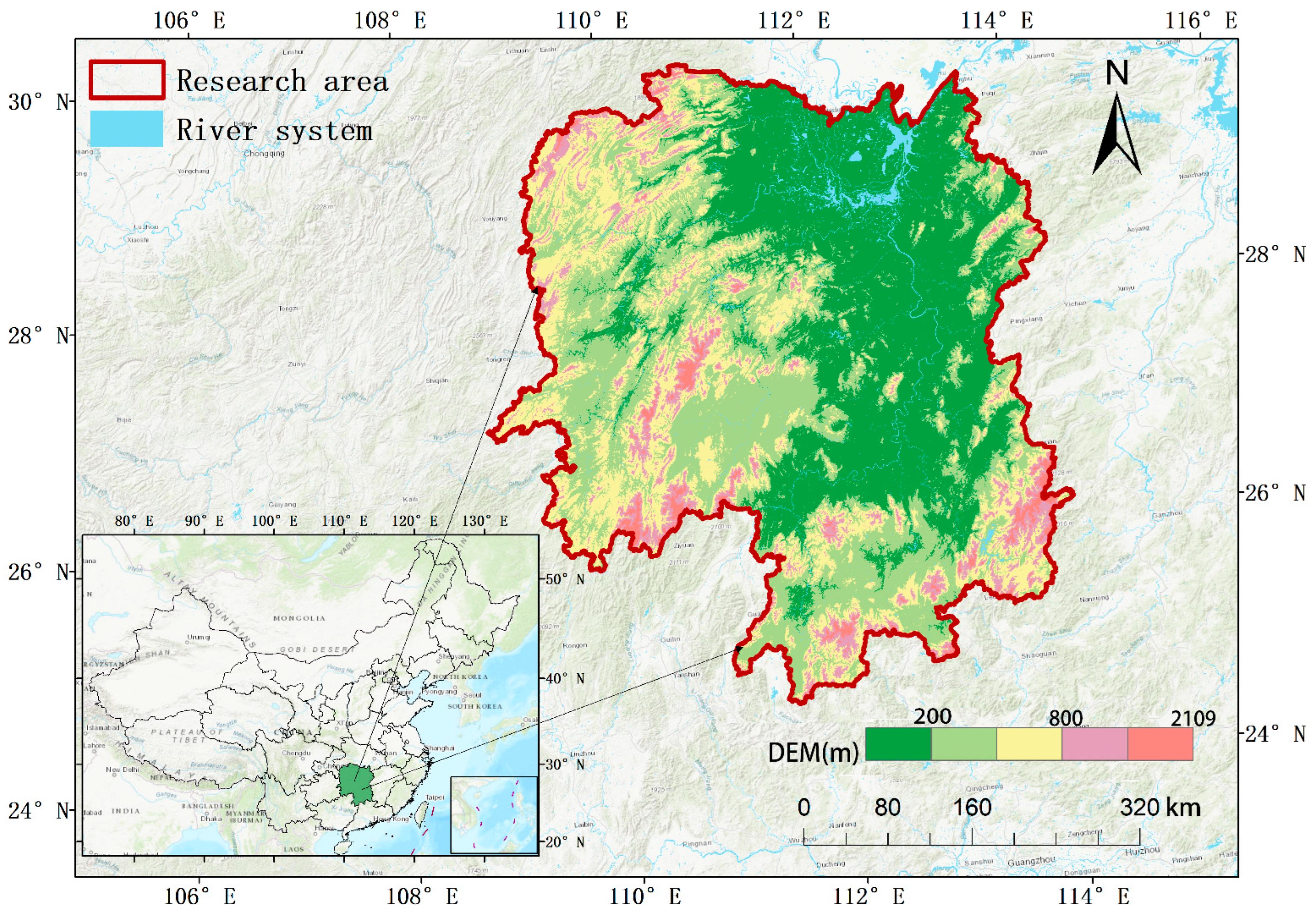
2.1. Overview of the Study Area
2.2. Data Sources and Preprocessing
2.2.1. NDVI Dataset
2.2.2. Driving Forces of the NDVI Dataset
2.2.3. Dataset of Different Sub-Zones
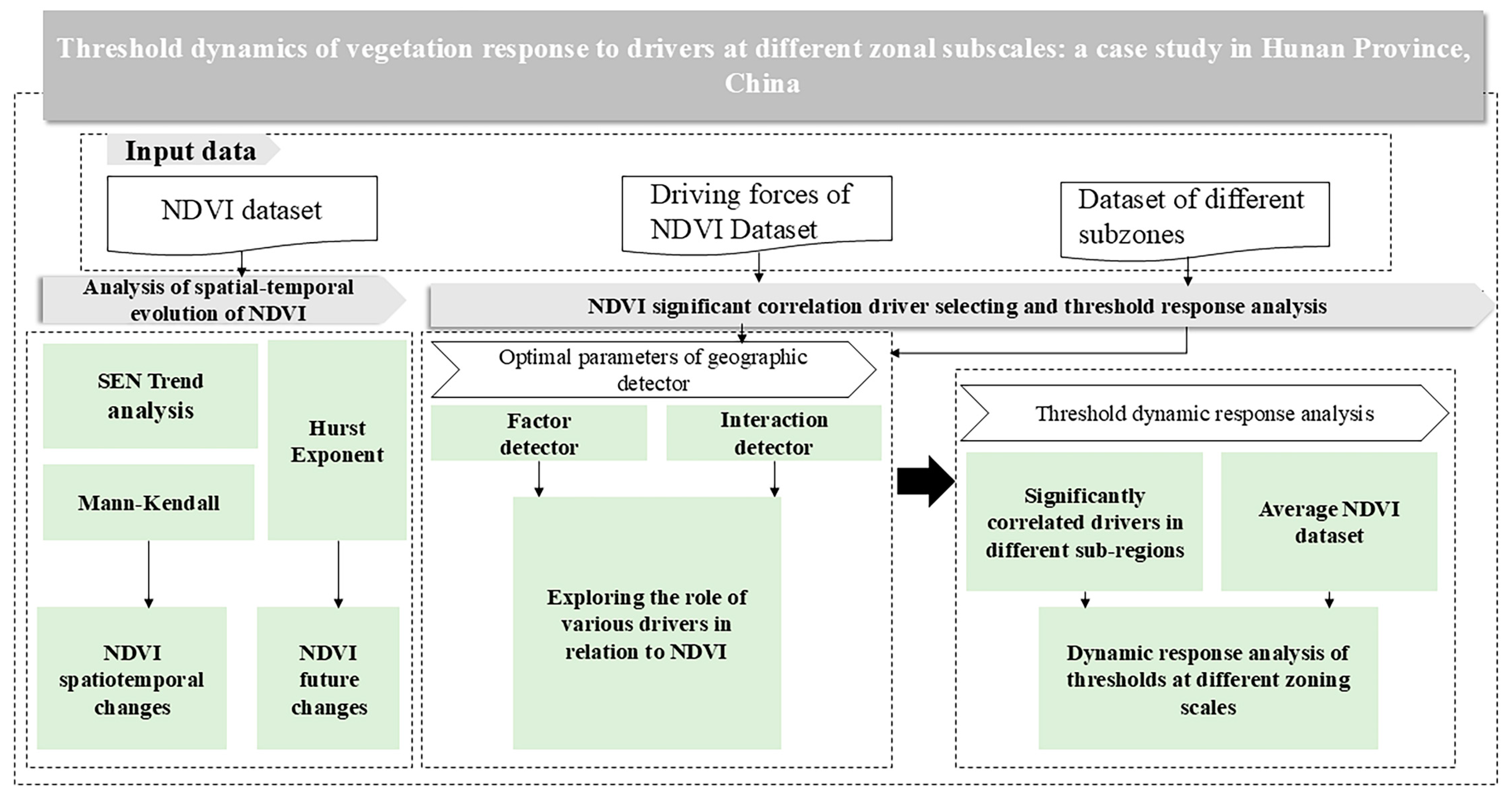
2.3. Methodology
2.3.1. Sen + Mann–Kendall Trend Analysis
2.3.2. Hurst Exponent
- When 0 < H < 0.5, the time series exhibits anti-persistence, meaning that increases are likely to be followed by decreases, and vice versa.
- When 0.5 < H < 1, the time series shows persistence, implying that trends are likely to continue in the same direction.
- When H = 0.5, the series behaves randomly, with no correlation between past and future values.
2.3.3. Indicator Selection and Information Extraction
- (1)
- Indicator selection:
- (2)
- Information extraction:
2.3.4. Optimal Parameters-Based Geographic Detector
2.3.5. Data Discretization
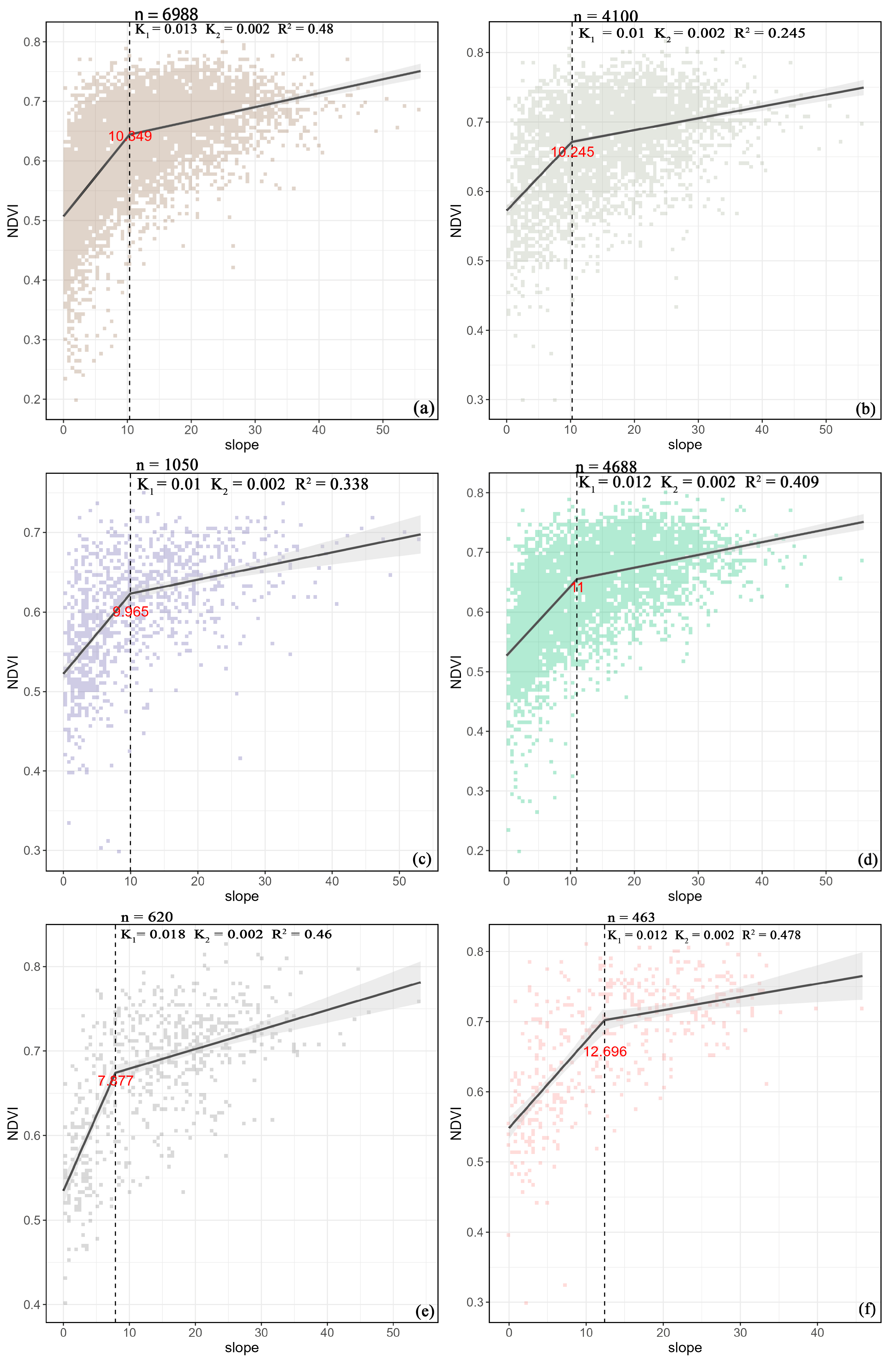
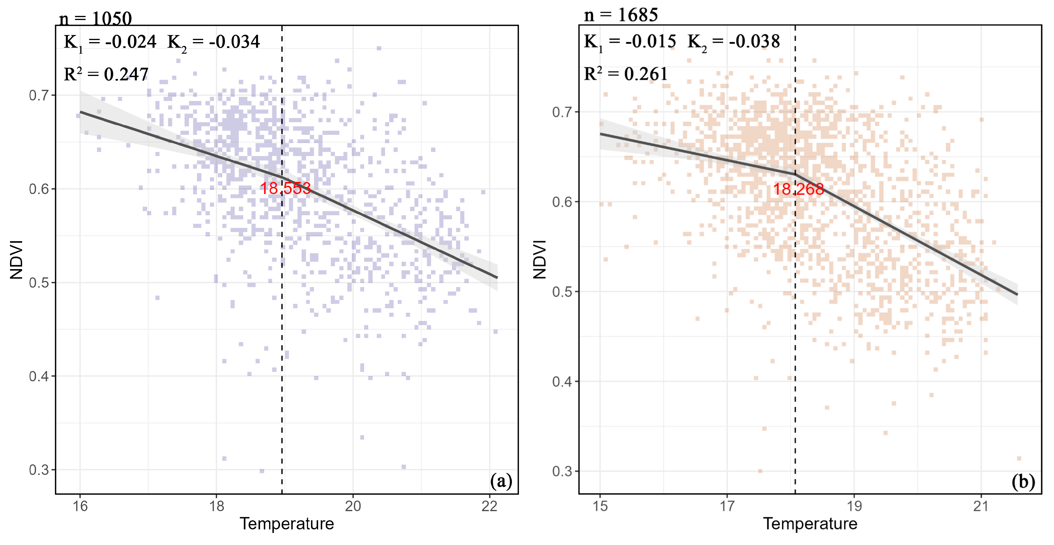
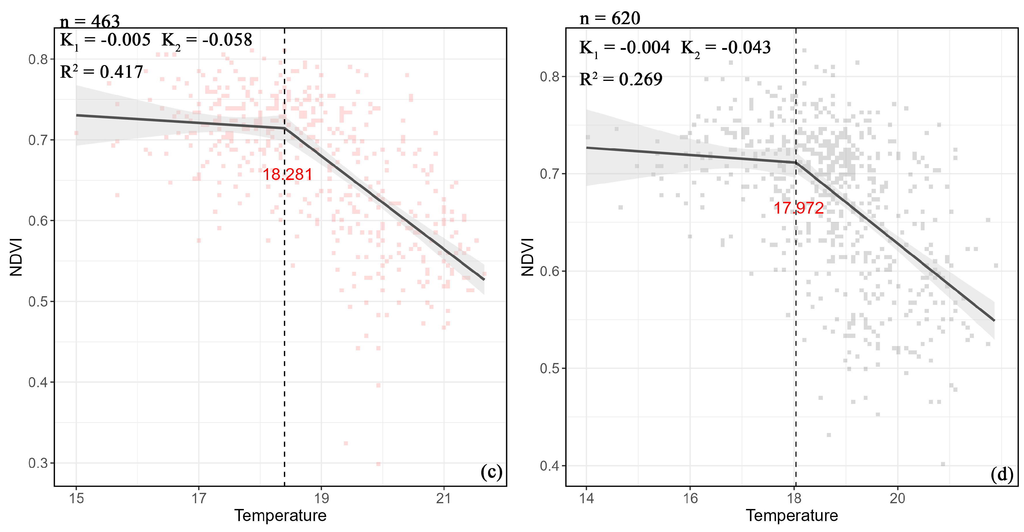
2.3.6. Threshold Response Analysis
3. Results
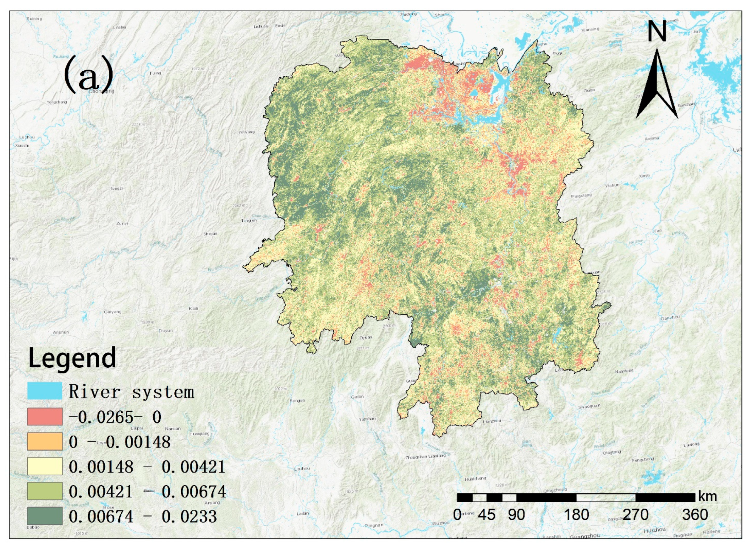
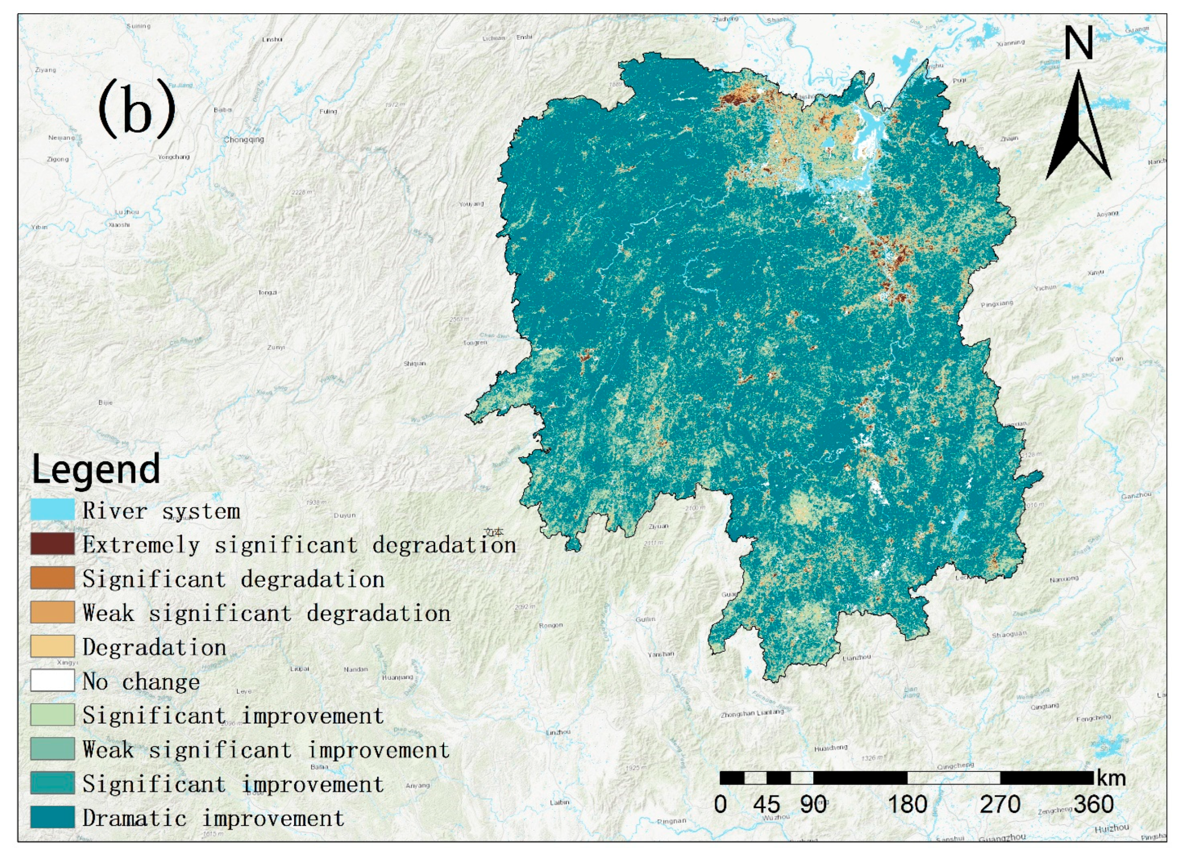
3.1. Analysis of Spatiotemporal Evolution of the NDVI
3.2. Future Evolution Characteristics
3.3. Geodetector Analysis of the NDVI’s Driving Factors
3.3.1. Influence Detection
Global Influence Detection
Regional Influence Detection
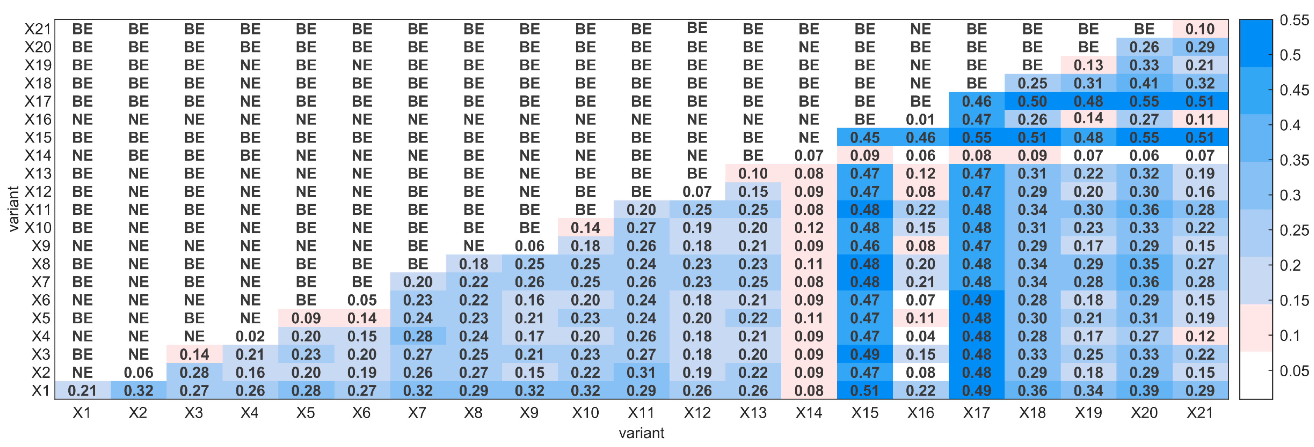
3.3.2. Interaction Detection
Global Interaction Detection
Zonal Interaction Detection
3.4. Threshold Response
4. Discussion
4.1. Long-Term Evolutionary Trends of the NDVI in Hunan Province
4.2. Differential Analysis of the NDVI’s Driving Mechanisms at Different Zonal Scales
4.3. Threshold Responses of the NDVI’s Drivers Can Guide Future Plantation Forestry in Hunan
5. Conclusions
Author Contributions
Funding
Data Availability Statement
Acknowledgments
Conflicts of Interest
References
- Jiang, L.; Guli, J.; Bao, A.; Guo, H.; Ndayisaba, F. Vegetation dynamics and responses to climate change and human activities in Central Asia. Sci. Total. Environ. 2017, 599–600, 967–980. [Google Scholar] [CrossRef]
- Meehl, G.A.; Stocker, T.F.; Collins, W.D.; Friedlingstein, P.; Gaye, A.T.; Gregory, J.M.; Kitoh, A.; Knutti, R.; Murphy, J.M.; Noda, A. Global Climate Projections; Cambridge University Press: Cambridge, UK, 2007; Chapter 10. [Google Scholar]
- Ren, J.T.; Xiao, J.H.; Ma, J.; He, P.X. Quantitative assessment of the potential benefits of global afforestation on ecosystem productivity. Environ. Res. Lett. 2025, 20, 034055. [Google Scholar] [CrossRef]
- Xia, J.; Chen, J.; Piao, S.; Ciais, P.; Luo, Y.; Wan, S. Terrestrial carbon cycle affected by non-uniform climate warming. Nat. Geosci. 2014, 7, 173–180. [Google Scholar] [CrossRef]
- Yang, L.; Guan, Q.; Jinkuo, L.; Tian, J.; Tan, Z.; Li, H. Evolution of NDVI secular trends and responses to climate change: A perspective from nonlinearity and nonstationarity characteristics. Remote Sens. Environ. 2021, 254, 112247. [Google Scholar] [CrossRef]
- Muir, C.; Southworth, J.; Khatami, R.; Herrero, H.; Akyapı, B. Vegetation Dynamics and Climatological Drivers in Ethiopia at the Turn of the Century. Remote Sens. 2021, 13, 3267. [Google Scholar] [CrossRef]
- Mishra, N.B.; Crews, K.A.; Neeti, N.; Meyer, T.; Young, K.R. MODIS derived vegetation greenness trends in African Savanna: Deconstructing and localizing the role of changing moisture availability, fire regime and anthropogenic impact. Remote Sens. Environ. 2015, 169, 192–204. [Google Scholar] [CrossRef]
- Wu, Y.; Tang, G.; Gu, H.; Liu, Y.; Yang, M.; Sun, L. The variation of vegetation greenness and underlying mechanisms in Guangdong province of China during 2001–2013 based on MODIS data. Sci. Total. Environ. 2019, 653, 536–546. [Google Scholar] [CrossRef]
- Feng, Q.; Ma, H.; Jiang, X.; Wang, X.; Cao, S. What Has Caused Desertification in China? Sci. Rep. 2015, 5, 15998. [Google Scholar] [CrossRef]
- Kong, C.; Huang, J.; Du, S.; Li, G. Exploring the Driving Forces of Vegetation Greening on the Loess Plateau at the County Scale. Forests 2024, 15, 486. [Google Scholar] [CrossRef]
- Xu, X.; Zhang, D. Comparing the long-term effects of artificial and natural vegetation restoration strategies: A case-study of Wuqi and its adjacent counties in northern China. Land Degrad. Dev. 2021, 32, 3930–3945. [Google Scholar] [CrossRef]
- Liu, H.; Zhang, M.; Lin, Z.; Xu, X. Spatial heterogeneity of the relationship between vegetation dynamics and climate change and their driving forces at multiple time scales in Southwest China. Agric. For. Meteorol. 2018, 256–257, 10–21. [Google Scholar] [CrossRef]
- He, G.; Zhen, X.; Li, Z.; Shen, W.; Han, J.; Zhang, L.; Li, X.; Zhang, R. Influence of Variations of Hydrothermal Conditions on Normalized Difference Vegetation Index in Typical Temperature Zones Along the East Coast of China. Front. Earth Sci. 2020, 8, 574101. [Google Scholar] [CrossRef]
- Malhi, Y.; Franklin, J.; Seddon, N.; Solan, M.; Turner, M.G.; Field, C.B.; Knowlton, N. Climate change and ecosystems: Threats, opportunities and solutions. Philos. Trans. R. Soc. B Biol. Sci. 2020, 375, 20190104. [Google Scholar] [CrossRef]
- Meng, X.; Pi, H.; Gao, X.; He, P.; Lei, J. A high-accuracy vegetation restoration potential mapping model integrating similar habitat and machine learning. Land Degrad. Dev. 2022, 34, 1208–1224. [Google Scholar] [CrossRef]
- Yang, L.; Shen, F.; Zhang, L.; Cai, Y.; Yi, F.; Zhou, C. Quantifying influences of natural and anthropogenic factors on vegetation changes using structural equation modeling: A case study in Jiangsu Province, China. J. Clean. Prod. 2021, 280, 124330. [Google Scholar] [CrossRef]
- Meng, X.; Gao, X.; Lei, J.; Li, S. Development of a multiscale discretization method for the geographical detector model. Int. J. Geogr. Inf. Sci. 2021, 35, 1650–1675. [Google Scholar] [CrossRef]
- He, P.; Sun, Z.; Ma, J.; Han, Z.; Dong, Y.; Liu, H.; Meng, X.; Ma, J. Dynamic characteristics and driving factors of vegetation greenness under changing environments in Xinjiang, China. Environ. Sci. Pollut. Res. 2021, 28, 42516–42532. [Google Scholar] [CrossRef]
- Tong, X.; Wang, K.; Brandt, M.; Yue, Y.; Liao, C.; Fensholt, R. Assessing Future Vegetation Trends and Restoration Prospects in the Karst Regions of Southwest China. Remote Sens. 2016, 8, 357. [Google Scholar] [CrossRef]
- Wan, Z. New refinements and validation of the MODIS Land-Surface Temperature/Emissivity products. Remote Sens. Environ. 2008, 112, 59–74. [Google Scholar] [CrossRef]
- Funk, C.; Peterson, P.; Landsfeld, M.; Pedreros, D.; Verdin, J.; Shukla, S.; Husak, G.; Rowland, J.; Harrison, L.; Hoell, A.; et al. The climate hazards infrared precipitation with stations—A new environmental record for monitoring extremes. Sci. Data 2015, 2, 150066. [Google Scholar] [CrossRef]
- Martens, B.; Miralles, D.G.; Lievens, H.; van der Schalie, R.; de Jeu, R.A.M.; Fernández-Prieto, D.; Beck, H.E.; Dorigo, W.A.; Verhoest, N.E.C. GLEAM v3: Satellite-based land evaporation and root-zone soil moisture. Geosci. Model Dev. 2017, 10, 1903–1925. [Google Scholar] [CrossRef]
- ASADEM Merged DEM Global 1 arc Second V001 [Data Set]. NASA EOSDIS Land Processes Distributed Active Archive Center: Washington, DC, USA. 2020. Available online: https://lpdaac.usgs.gov/products/nasadem_hgtv001/ (accessed on 15 February 2024).
- Yang, Z.; Hu, J.; Wang, Z.; Chen, S. A new model based on coupling coordination analysis incorporates the development rate for urbanization and ecosystem services assessment: A case of the Yangtze River Delta. Ecol. Indic. 2024, 159, 111596. [Google Scholar] [CrossRef]
- Tatem, A.J. WorldPop, open data for spatial demography. Sci. Data 2017, 4, 170004. [Google Scholar] [CrossRef]
- Mann, H.B. Nonparametric Tests Against Trend. Nonparametric 1945, 13, 245–259. [Google Scholar] [CrossRef]
- Alashan, S. Non-monotonic trend analysis using Mann–Kendall with self-quantiles. Theor. Appl. Climatol. 2024, 155, 901–910. [Google Scholar] [CrossRef]
- Mandelbrot, B.B.; Wallis, J.R. Robustness of the rescaled range R/S in the measurement of noncyclic long-run statistical dependence. Water Resour. Res. 1969, 5, 967–988. [Google Scholar] [CrossRef]
- Gu, Z.; Duan, X.; Shi, Y.; Li, Y.; Pan, X. Spatiotemporal variation in vegetation coverage and its response to climatic factors in the Red River Basin, China. Ecol. Indic. 2018, 93, 54–64. [Google Scholar] [CrossRef]
- Tan, F.; Lu, Z.; Zeng, F. Study on the trade-off/synergy spatiotemporal benefits of ecosystem services and its influencing factors in hilly areas of southern China. Front. Ecol. Evol. 2024, 11, 1342766. [Google Scholar] [CrossRef]
- Song, Y.; Wang, J.; Ge, Y.; Xu, C. An optimal parameters-based geographical detector model enhances geographic characteristics of explanatory variables for spatial heterogeneity analysis: Cases with different types of spatial data. GISci. Remote Sens. 2020, 57, 593–610. [Google Scholar] [CrossRef]
- GB/T 15772-2008; General Principles for Comprehensive Planning of Soil and Water Conservation. General Administration of Quality Supervision, Inspection and Quarantine of the People’s Republic of China: Beijing, China, 2008.
- Luo, Y.; Lü, Y.; Guo, X.; Liu, Y.; Zhang, L.; Li, T. The thresholds of forest-to-grassland ratios can be critical for harmonizing ecosystem service relationships spatiotemporally in dryland regions. Appl. Geogr. 2024, 169, 103334. [Google Scholar] [CrossRef]
- Ma, J.; Wang, J.; He, S.; Zhang, J.; Liu, L.; Zhong, X. Direct and indirect effects of urbanization on vegetation: A survey of Yunnan central urban Economic Circle, China. Ecol. Indic. 2024, 166, 112536. [Google Scholar] [CrossRef]
- Yang, S.; Yang, X.; Zhang, J.; Gao, X.; Zhou, J.; Wu, X. Assessing the impacts of rural depopulation and urbanization on vegetation cover: Based on land use and nighttime light data in China, 2000–2020. Ecol. Indic. 2024, 159, 111639. [Google Scholar] [CrossRef]
- Ma, J.; Xiao, X.; Miao, R.; Li, Y.; Chen, B.; Zhang, Y.; Zhao, B. Trends and controls of terrestrial gross primary productivity of China during 2000–2016. Environ. Res. Lett. 2019, 14, 084032. [Google Scholar] [CrossRef]
- Jiang, Z.; Lian, Y.; Qin, X. Rocky Desertification in Southwest China: Impacts, Causes, and Restoration. Earth Sci. Rev. 2014, 132, 1–12. [Google Scholar] [CrossRef]
- Han, W.; Chen, D.; Li, H.; Chang, Z.; Chen, J.; Ye, L.; Liu, S.; Wang, Z. Spatiotemporal Variation of NDVI in Anhui Province from 2001 to 2019 and Its Response to Climatic Factors. Forests 2022, 13, 1643. [Google Scholar] [CrossRef]
- Cheng, J.; Qian, M.; Liu, J.; Chen, X.; Zuo, Y.; Zhao, Z.; Zhang, J. How Did the Southwest China Mountains Turn Green from 2000 to 2020? A Case Study in Chongqing. Forests 2023, 14, 1563. [Google Scholar] [CrossRef]
- Piao, S.; Wang, X.; Park, T.; Chen, C.; Lian, X.; He, Y.; Bjerke, J.W.; Chen, A.; Ciais, P.; Tømmervik, H.; et al. Characteristics, drivers and feedbacks of global greening. Nat. Rev. Earth Environ. 2019, 1, 14–27. [Google Scholar] [CrossRef]
- Guo, E.; Wang, Y.; Wang, C.; Sun, Z.; Bao, Y.; Mandula, N.; Jirigala, B.; Bao, Y.; Li, H. NDVI Indicates Long-Term Dynamics of Vegetation and Its Driving Forces from Climatic and Anthropogenic Factors in Mongolian Plateau. Remote Sens. 2021, 13, 688. [Google Scholar] [CrossRef]
- Fang, J.; Kato, T.; Guo, Z.; Yang, Y.; Hu, H.; Shen, H.; Zhao, X.; Kishimoto-Mo, A.W.; Tang, Y.; Houghton, R.A. Evidence for environmentally enhanced forest growth. Proc. Natl. Acad. Sci. USA 2014, 111, 9527–9532. [Google Scholar] [CrossRef]
- Tao, J.; Xu, T.; Dong, J.; Yu, X.; Jiang, Y.; Zhang, Y.; Huang, K.; Zhu, J.; Dong, J.; Xu, Y.; et al. Elevation-dependent effects of climate change on vegetation greenness in the high mountains of southwest China during 1982–2013. Int. J. Climatol. 2017, 38, 2029–2038. [Google Scholar] [CrossRef]
- Jiang, S.; Chen, X.; Smettem, K.; Wang, T. Climate and land use influences on changing spatiotemporal patterns of mountain vegetation cover in southwest China. Ecol. Indic. 2021, 121, 107193. [Google Scholar] [CrossRef]
- Liu, Y.; Huang, H.; Meng, L.; Liu, M.; Wu, Z.; Liu, T.; Labat, D. Spatial-temporal evolution of vegetation coverage and its relationship with terrain and human factors in the upper reaches of Ganjiang River Basin, China. Front. Earth Sci. 2023, 10, 1043403. [Google Scholar] [CrossRef]
- Du, J.; Quan, Z.; Fang, S.; Liu, C.; Wu, J.; Fu, Q. Spatiotemporal changes in vegetation coverage and its causes in China since the Chinese economic reform. Environ. Sci. Pollut. Res. 2020, 27, 1144–1159. [Google Scholar] [CrossRef] [PubMed]
- Li, B.; Wang, Y.; Wang, W.; Wang, C.; Lin, A. Satellite remote sensing analysis to monitor revegetation in the Yangtze River basin, China. Land Degrad. Dev. 2021, 33, 68–78. [Google Scholar] [CrossRef]
- Hou, W.; Gao, J.; Wu, S.; Dai, E. Interannual Variations in Growing-Season NDVI and Its Correlation with Climate Variables in the Southwestern Karst Region of China. Remote Sens. 2015, 7, 11105–11124. [Google Scholar] [CrossRef]
- Wenming, A.; Zongshan, L.; Shuai, W.; Xing, W.; Yihe, L.; Guohua, L.; Bojie, F. Exploring the effects of the “Grain for Green” program on the differences in soil water in the semi-arid LoessPlateau of China. Ecol. Eng. 2017, 107, 144–151. [Google Scholar] [CrossRef]
- Fu, B.; Wu, X.; Wang, Z.; Wu, X.; Wang, S. Coupling human and natural systems for sustainability: Experience from China’s Loess Plateau. Earth Syst. Dyn. 2022, 13, 795–808. [Google Scholar] [CrossRef]
- Fu, B.; Liu, Y.; Meadows, M.E. Ecological restoration for sustainable development in China. Natl. Sci. Rev. 2023, 10, nwad033. [Google Scholar] [CrossRef]
- You, G.; Liu, B.; Zou, C.; Li, H.; McKenzie, S.; He, Y.; Gao, J.; Jia, X.; Altaf Arain, M.; Wang, S.; et al. Sensitivity of vegetation dynamics to climate variability in a forest-steppe transition ecozone, north-eastern Inner Mongolia, China. Ecol. Indic. 2021, 120, 106833. [Google Scholar] [CrossRef]
- Lee, B.X.; Kjaerulf, F.; Turner, S.; Cohen, L.; Donnelly, P.D.; Muggah, R.; Davis, R.; Realini, A.; Kieselbach, B.; MacGregor, L.S.; et al. Transforming Our World: Implementing the 2030 Agenda Through Sustainable Development Goal Indicators. J. Public Health Policy 2016, 37, 13–31. [Google Scholar] [CrossRef]
- Vaz, A.S.; Amorim, F.; Pereira, P.; Antunes, S.; Rebelo, H.; Oliveira, N.G. Integrating conservation targets and ecosystem services in landscape spatial planning from Portugal. Landsc. Urban Plan. 2021, 215, 104213. [Google Scholar] [CrossRef]
- Jamei, E.; Rajagopalan, P.; Seyedmahmoudian, M.; Jamei, Y. Review on the impact of urban geometry and pedestrian level greening on outdoor thermal comfort. Renew. Sustain. Energy Rev. 2016, 54, 1002–1017. [Google Scholar] [CrossRef]
- Tan, Z.; Christopoulos, G.; Roberts, A.C.; Ren, G.; Ouyang, W.; Lo, K.; Ho, C. The comparative thermal experience of young and old pedestrians in urban green spaces and in densely built areas. Urban For. Urban Green. 2025, 105, 128712. [Google Scholar] [CrossRef]
- Yao, R.; Cao, J.; Wang, L.; Zhang, W.; Wu, X. Urbanization effects on vegetation cover in major African cities during 2001–2017. Int. J. Appl. Earth Obs. Geoinf. 2019, 75, 44–53. [Google Scholar] [CrossRef]
- Li, W.; Cao, Q.; Lang, K.; Wu, J. Linking potential heat source and sink to urban heat island: Heterogeneous effects of landscape pattern on land surface temperature. Sci. Total. Environ. 2017, 586, 457–465. [Google Scholar] [CrossRef]
- Rahaman, Z.A.; Kafy, A.A.; Saha, M.; Rahim, A.A.; Almulhim, A.I.; Rahaman, S.N.; Fattah, M.A.; Rahman, M.T.; Kalaivani, S.; Al Rakib, A. Assessing the impacts of vegetation cover loss on surface temperature, urban heat island and carbon emission in Penang city, Malaysia. Build. Environ. 2022, 222, 109335. [Google Scholar] [CrossRef]
- Jamei, Y.; Rajagopalan, P.; Sun, Q.C. Spatial structure of surface urban heat island and its relationship with vegetation and built-up areas in Melbourne, Australia. Sci. Total. Environ. 2019, 659, 1335–1351. [Google Scholar] [CrossRef]
- Hansen, B. Threshold Effects in Non-Dynamic Panels: Estimation, Testing, and Inference. J. Econom. 1999, 93, 345–368. [Google Scholar] [CrossRef]
- Wallington, T.J.; Hobbs, R.J.; Moore, S.A. Implications of Current Ecological Thinking for Biodiversity Conservation: A Review of the Salient Issues. Ecol. Soc. 2005, 10, 15. [Google Scholar] [CrossRef]
- Tangjialeke, W.; Zou, J.; Ding, J.; Yahefujiang, H.; Huang, S.; Li, J. Analysis of drought response thresholds and drought-causing factors of central Asian vegetation. Ecol. Indic. 2024, 169, 112926. [Google Scholar] [CrossRef]
- Zi, C.; Jie, W.; Hong-Bo, C. CO2 emissions and urbanization correlation in China based on threshold analysis. Ecol. Indic. 2016, 61, 193–201. [Google Scholar] [CrossRef]
- Byers, J.E.; Cuddington, K.; Jones, C.G.; Talley, T.S.; Hastings, A.; Lambrinos, J.G.; Crooks, J.A.; Wilson, W.G. Using ecosystem engineers to restore ecological systems. Trends Ecol. Evol. 2006, 21, 493–500. [Google Scholar] [CrossRef] [PubMed]
- Suding, K.N.; Gross, K.L.; Houseman, G.R. Alternative states and positive feedbacks in restoration ecology. Trends Ecol. Evol. 2004, 19, 46–53. [Google Scholar] [CrossRef] [PubMed]
- Xie, Y.; Wang, L.; An, R.; Luo, X.; Lu, Y.; Liu, Y.; Yao, S.; Liu, Y. The Effect of Sloping Land Conversion Program on Soil Erosion in Shaanxi Province, China: A Spatial Panel Approach. Front. Environ. Sci. 2022, 10, 913712. [Google Scholar] [CrossRef]
- Yin, R.; Rothstein, D.; Qi, J.; Liu, S. Methodology for an Integrative Assessment of China’s Ecological Restoration Programs. In An Integrated Assessment of China’s Ecological Restoration Programs; Springer: Berlin/Heidelberg, Germany, 2009; pp. 39–54. [Google Scholar]
- Guha, S.; Govil, H. Land surface temperature and normalized difference vegetation index relationship: A seasonal study on a tropical city. SN Appl. Sci. 2020, 2, 1661. [Google Scholar] [CrossRef]
- Ullah, W.; Ahmad, K.; Ullah, S.; Tahir, A.A.; Javed, M.F.; Nazir, A.; Abbasi, A.M.; Aziz, M.; Mohamed, A. Analysis of the relationship among land surface temperature (LST), land use land cover (LULC), and normalized difference vegetation index (NDVI) with topographic elements in the lower Himalayan region. Heliyon 2023, 9, e13322. [Google Scholar] [CrossRef]
- Zhu, S.Y.; Xu, J.; Zeng, J.Y.; He, P.X.; Wang, Y.P.; Bao, S.N.; Ma, J.; Shi, J.C. UFLUX-GPP: A Cost-Effective Framework for Quantifying Daily Terrestrial Ecosystem Carbon Uptake Using Satellite Data. IEEE Trans. Geosci. Remote Sens. 2024, 62, 4107917. [Google Scholar] [CrossRef]
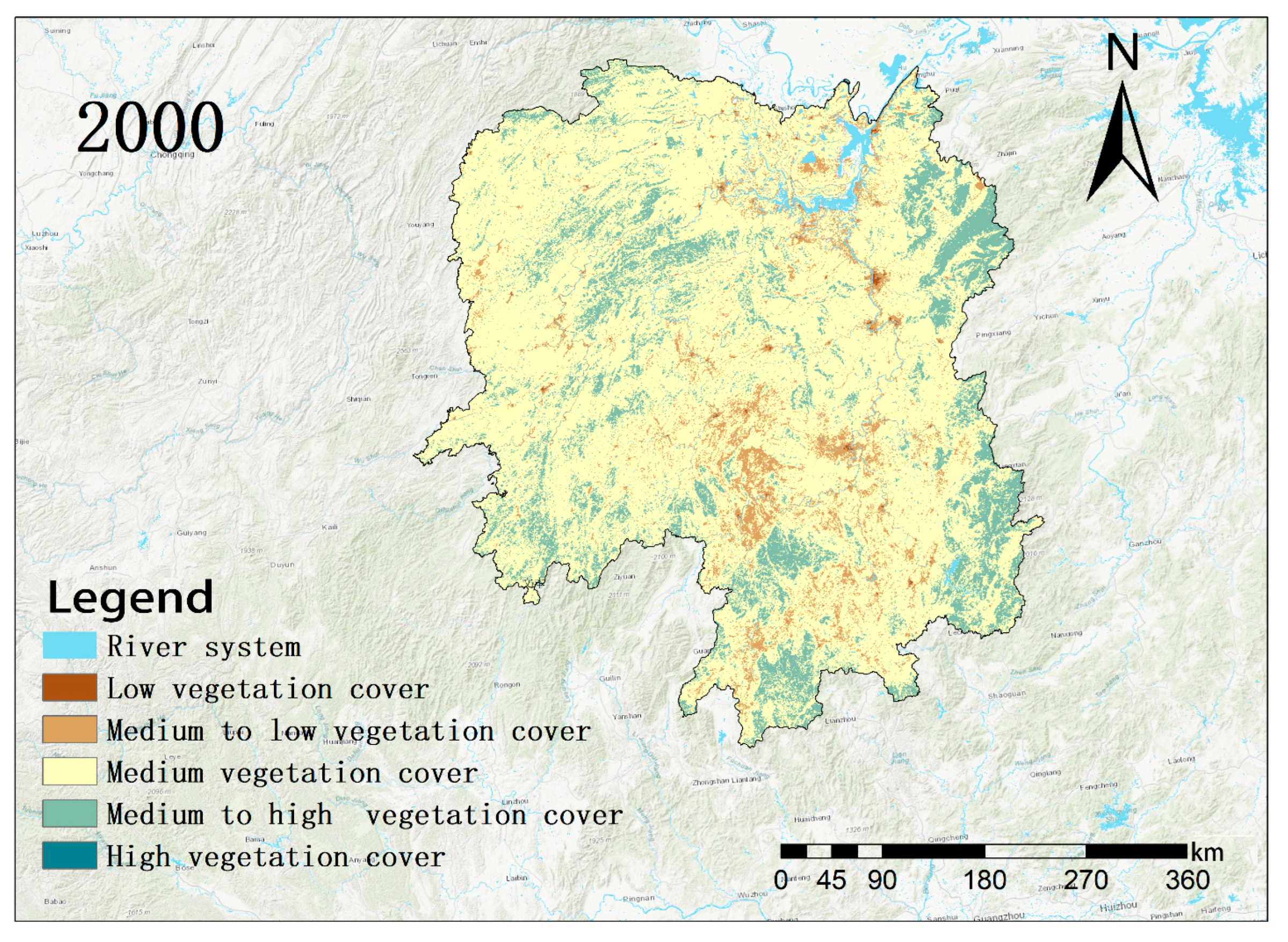
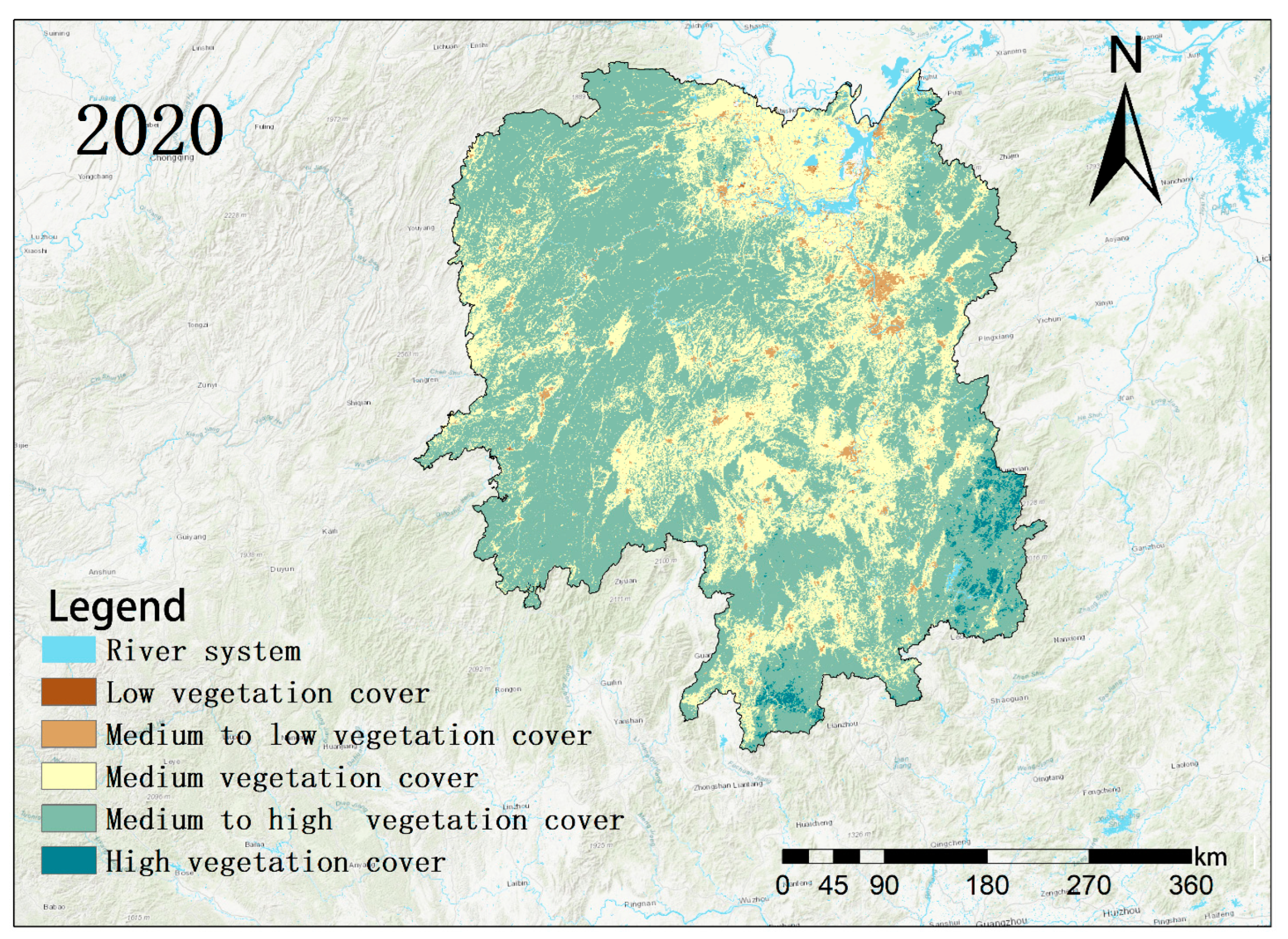
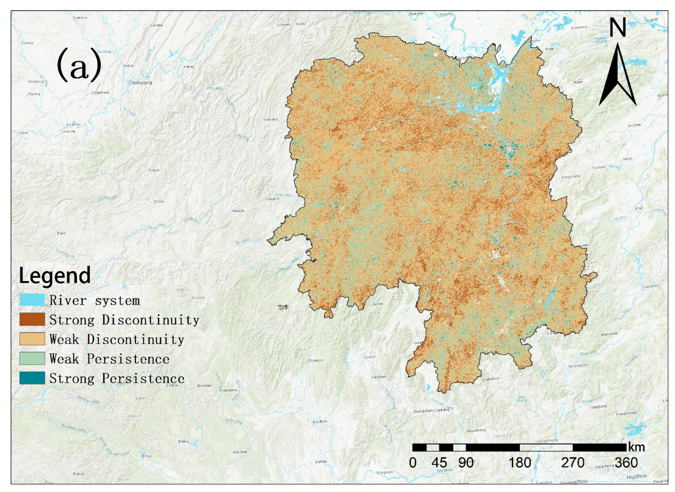


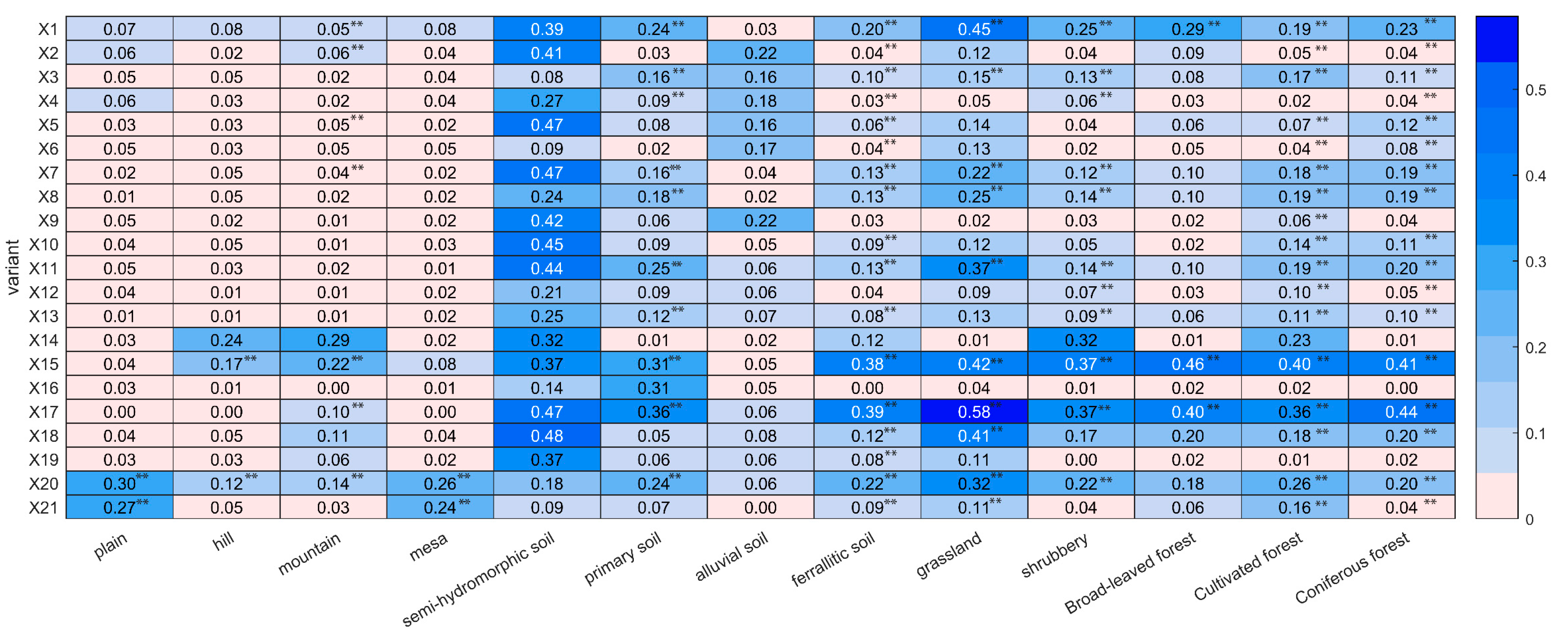



| Categories | Variant | Dataset | Abbreviation | Year Range | Time Resolution | Data Source |
|---|---|---|---|---|---|---|
| / | Y | Normalized difference vegetation index | NDVI | 2000–2020 | 16d | NASA |
| Climatic factors | X1 | Mean annual temperature | TEM | 2000–2020 | 8d | NOAA |
| X2 | Mean annual precipitation | PRE | 2000–2020 | 1d | GEE | |
| X3 | Effective photosynthetic radiation | PAR | 2000–2020 | 1M | NASA | |
| X4 | Aridity index | SPEI | 2000–2020 | 1M | SPEI | |
| X5 | Actual evaporation | E | 2000–2020 | 1a | GLEAM | |
| X6 | Potential evaporation | Ep | 2000–2020 | 1a | GLEAM | |
| X7 | Interception loss | Ei | 2000–2020 | 1a | GLEAM | |
| X8 | Bare soil evaporation | Eb | 2000–2020 | 1a | GLEAM | |
| X9 | Transpiration | Et | 2000–2020 | 1a | GLEAM | |
| X10 | Open-water evaporation | Ew | 2000–2020 | 1a | GLEAM | |
| X11 | Evaporative stress factor | S | 2000–2020 | 1a | GLEAM | |
| X12 | Root zone soil moisture | SMroot | 2000–2020 | 1a | GLEAM | |
| X13 | Surface soil moisture; 0–10 | SMsurf | 2000–2020 | 1a | GLEAM | |
| Topographical geomorphology | X14 | Elevation | DEM | 2000 | GEE | |
| X15 | Slope | Slope | 2000 | GEE | ||
| X16 | Aspect | Aspect | 2000 | GEE | ||
| X17 | Geomorphological type | Geomorphy type | 2009 | RESDC | ||
| Soil | X18 | Soil type | Soil type | RESDC | ||
| Vegetation | X19 | Vegetation type | Vegetation type | 2001 | RESDC | |
| Human activity | X20 | Land use type | Land use type | 2000–2020 | 5a | RESDC |
| X21 | Population density | Population density | 2000–2020 | 1a | WPOP |
| Variant | Dataset | Abbreviation | Year Range | Time Resolution | Data Source |
|---|---|---|---|---|---|
| X1 | Mean annual temperature | TEM | 2000–2020 | 8d | NOAA |
| X2 | Mean annual precipitation | PRE | 2000–2020 | 1d | GEE |
| X3 | Effective photosynthetic radiation | PAR | 2000–2020 | 1M | NASA |
| X4 | Aridity index | SPEI | 2000–2020 | 1M | SPEI |
| X5 | Actual evaporation | E | 2000–2020 | 1a | GLEAM |
| X6 | Potential evaporation | Ep | 2000–2020 | 1a | GLEAM |
| X7 | Interception loss | Ei | 2000–2020 | 1a | GLEAM |
| X8 | Bare soil evaporation | Eb | 2000–2020 | 1a | GLEAM |
| X9 | Transpiration | Et | 2000–2020 | 1a | GLEAM |
| X10 | Open-water evaporation | Ew | 2000–2020 | 1a | GLEAM |
| X11 | Evaporative stress factor | S | 2000–2020 | 1a | GLEAM |
| X12 | Root zone soil moisture | SMroot | 2000–2020 | 1a | GLEAM |
| X13 | Surface soil moisture; 0–10 | SMsurf | 2000–2020 | 1a | GLEAM |
| X14 | Elevation | DEM | 2000 | GEE | |
| X15 | Slope | Slope | 2000 | GEE | |
| X16 | Aspect | Aspect | 2000 | GEE | |
| X17 | Geomorphological type | Geomorphy type | 2009 | RESDC | |
| X18 | Soil type | Soil type | RESDC | ||
| X19 | Vegetation type | Vegetation type | 2001 | RESDC | |
| X20 | Land use type | Land use type | 2000–2020 | 5a | RESDC |
| X21 | Population density | Population density | 2000–2020 | 1a | WPOP |
| Basis of Judgment | Interaction |
|---|---|
| q(X1∩X2) < Min[q(X1), q(X2)] | Nonlinear attenuation |
| Min[q(X1), q(X2)] < q(X1∩X2) < Max[q(X1), q(X2)] | Single-factor nonlinear attenuation |
| q(X1∩X2) > Max[q(X1), q(X2)] | Two-factor enhancement |
| q(X1∩X2) = q(X1) + q(X2) | Standalone |
| q(X1∩X2) > q(X1) + q(X2) | Nonlinear enhancement |
| NDVI Rating | Low Vegetation Cover | Medium–Low Vegetation Cover | Medium Vegetation Cover | Medium–High Vegetation Cover | High Vegetation Cover | Total 2020 | Shift |
|---|---|---|---|---|---|---|---|
| Low vegetation cover | 55 | 163 | 46 | 0 | 0 | 263 | 208 |
| Medium–low vegetation cover | 334 | 2878 | 2009 | 2 | 0 | 5223 | 2345 |
| Medium vegetation cover | 49 | 12,283 | 59,389 | 293 | 0 | 72,015 | 12,625 |
| Medium–high vegetation cover | 1 | 881 | 97,928 | 29,951 | 0 | 128,759 | 98,809 |
| High vegetation cover | 0 | 0 | 417 | 1658 | 0 | 2075 | 2075 |
| Total 2000 | 438 | 16,205 | 159,789 | 31,903 | 0 | ||
| Transfer out | 384 | 13,326 | 100,399 | 1953 | 0 | ||
| Magnitude of change | −175 | −10,981 | −87,773 | 96,856 | 2075 |
| Factor | X1 | X2 | X3 | X4 | X5 | X6 | X7 | X8 | X9 | X10 | |
| q | 0.210 | 0.0596 | 0.136 | 0.0203 | 0.0935 | 0.0527 | 0.195 | 0.185 | 0.0605 | 0.141 | |
| p | 0.00 | 0.00 | 0.00 | 0.00 | 0.00 | 0.00 | 0.00 | 0.00 | 0.00 | 0.00 | |
| Factor | X11 | X12 | X13 | X14 | X15 | X16 | X17 | X18 | X19 | X20 | X21 |
| q | 0.202 | 0.0683 | 0.104 | 0.221 | 0.453 | 0.0089 | 0.462 | 0.251 | 0.131 | 0.258 | 0.096 |
| p | 0.00 | 0.00 | 0.00 | 0.00 | 0.00 | 0.0024 | 0.00 | 0.00 | 0.00 | 0.00 | 0.00 |
| Partition Type | Zoning Unit | Dominant Interactions 1 | q-Value | Dominant Interactions 2 | q-Value | Dominant Interactions 3 | q-Value |
|---|---|---|---|---|---|---|---|
| Geology | Plains | X1∩X20 | 0.421 ** | X16∩X20 | 0.402 ** | X11∩X20 | 0.399 ** |
| Hills | X15∩X20 | 0.274 * | X1∩X15 | 0.234 * | X15∩X21 | 0.215 * | |
| Mountains | X15∩X20 | 0.310 * | X15∩X18 | 0.295 * | X15∩X19 | 0.273 * | |
| Mesas | X1∩X20 | 0.352 ** | X15∩X20 | 0.340 * | X1∩X21 | 0.320 * | |
| Soil area | Semi-hydromorphic soil | X5∩X16 | 0.771 ** | X9∩X16 | 0.751 ** | X10∩X16 | 0.740 ** |
| Primary soil | X17∩X20 | 0.463 * | X15∩X20 | 0.450 * | X15∩X17 | 0.440 * | |
| Alluvial soil | X5∩X16 | 0.523 ** | X6∩X16 | 0.460 ** | X4∩X16 | 0.450 ** | |
| Ferrallitic soil | X17∩X20 | 0.490 * | X15∩X17 | 0.487 * | X15∩X20 | 0.483 * | |
| Vegetation zone | Grassland | X11∩X17 | 0.674 * | X17∩X20 | 0.671 * | X8∩X17 | 0.663 * |
| Shrubbery | X15∩X17 | 0.478 * | X15∩X20 | 0.470 * | X1∩X15 | 0.451 * | |
| Broadleaf forest | X1∩X15 | 0.575 * | X15∩X17 | 0.559 * | X2∩X15 | 0.534 ** | |
| Cultivated forest | X15∩X20 | 0.541 * | X15∩X21 | 0.520 * | X17∩X20 | 0.515 * | |
| Coniferous forest | X15∩X17 | 0.527 * | X17∩X20 | 0.505 * | X15∩X20 | 0.498 * |
Disclaimer/Publisher’s Note: The statements, opinions and data contained in all publications are solely those of the individual author(s) and contributor(s) and not of MDPI and/or the editor(s). MDPI and/or the editor(s) disclaim responsibility for any injury to people or property resulting from any ideas, methods, instructions or products referred to in the content. |
© 2025 by the authors. Licensee MDPI, Basel, Switzerland. This article is an open access article distributed under the terms and conditions of the Creative Commons Attribution (CC BY) license (https://creativecommons.org/licenses/by/4.0/).
Share and Cite
Zhang, Q.; Xiao, J.; Meng, X.; Ma, J.; He, P. Spatial Heterogeneity Analysis of the Driving Mechanisms and Threshold Responses of Vegetation at Different Regional Scales in Hunan Province. Forests 2025, 16, 515. https://doi.org/10.3390/f16030515
Zhang Q, Xiao J, Meng X, Ma J, He P. Spatial Heterogeneity Analysis of the Driving Mechanisms and Threshold Responses of Vegetation at Different Regional Scales in Hunan Province. Forests. 2025; 16(3):515. https://doi.org/10.3390/f16030515
Chicago/Turabian StyleZhang, Qingbin, Jianhua Xiao, Xiaoyu Meng, Jun Ma, and Panxing He. 2025. "Spatial Heterogeneity Analysis of the Driving Mechanisms and Threshold Responses of Vegetation at Different Regional Scales in Hunan Province" Forests 16, no. 3: 515. https://doi.org/10.3390/f16030515
APA StyleZhang, Q., Xiao, J., Meng, X., Ma, J., & He, P. (2025). Spatial Heterogeneity Analysis of the Driving Mechanisms and Threshold Responses of Vegetation at Different Regional Scales in Hunan Province. Forests, 16(3), 515. https://doi.org/10.3390/f16030515


