
GIS-Based Spatial Modeling of Soil Erosion and Wildfire Susceptibility Using VIIRS and Sentinel-2 Data: A Case Study of Šar Mountains National Park, Serbia

 ,
, 
 , , and
Abstract
1. Introduction
2. Materials and Methods
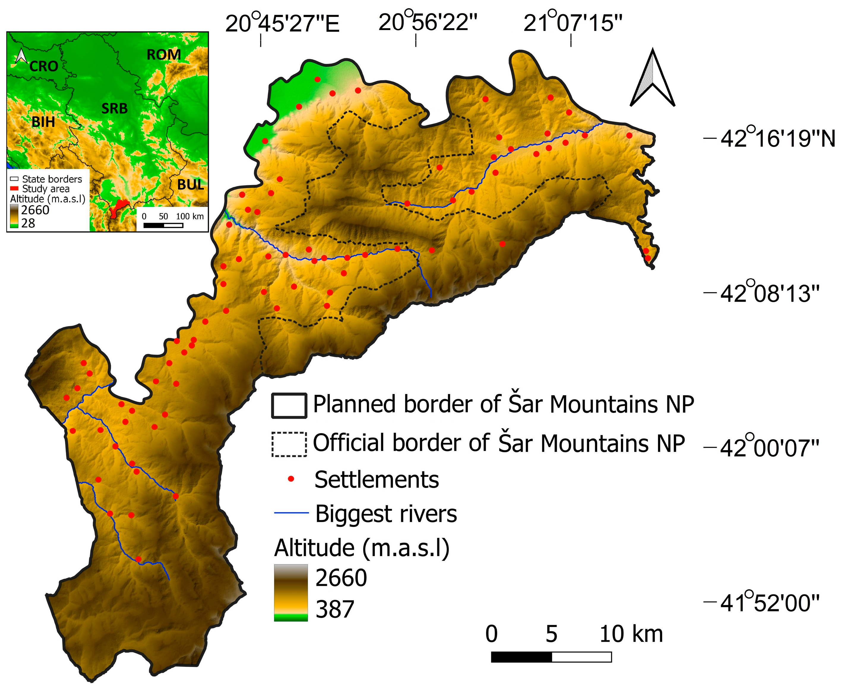
2.1. Study Area
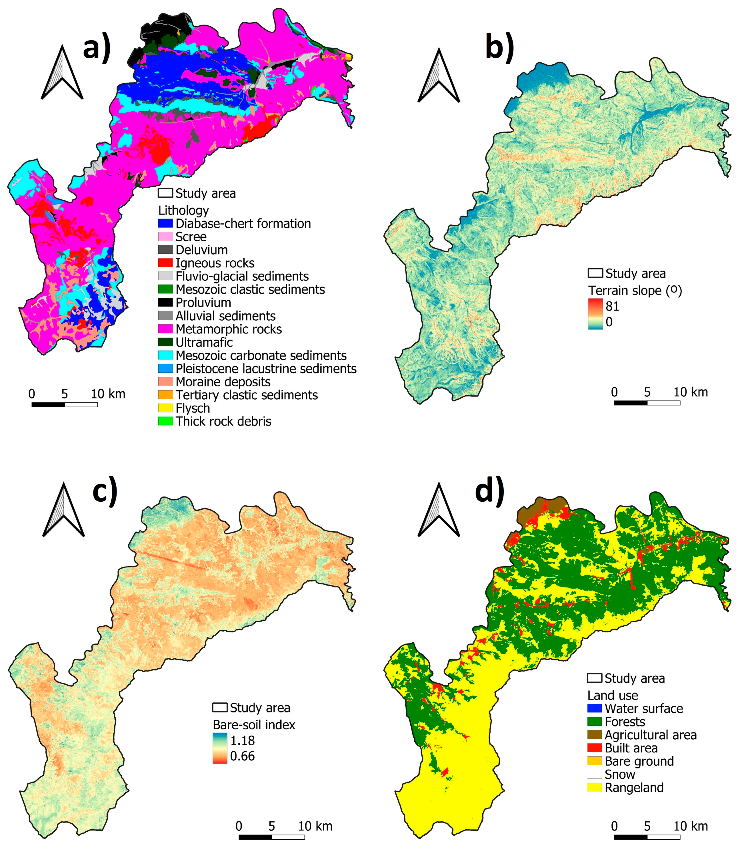
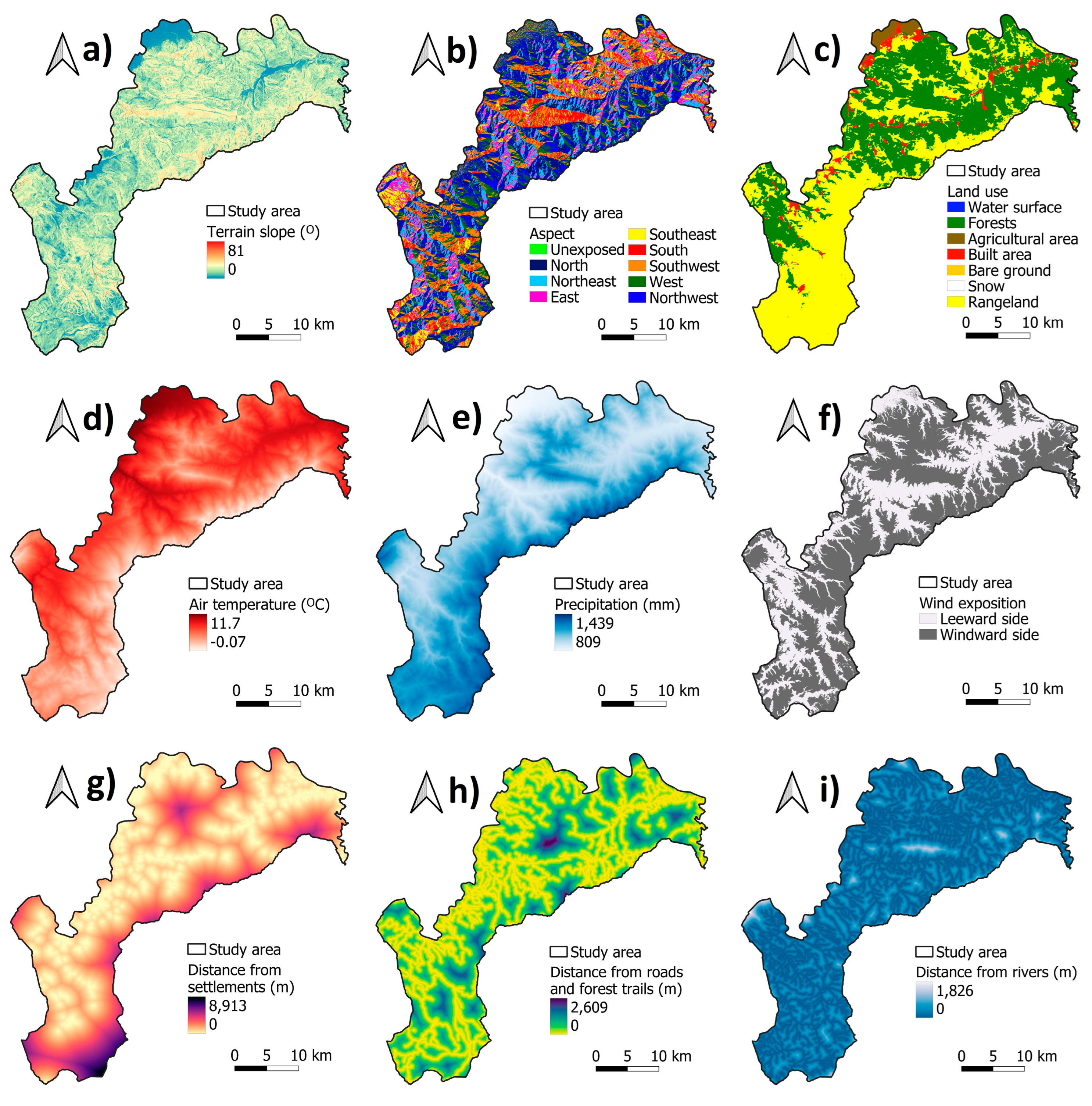
2.2. Data Sets and Criteria
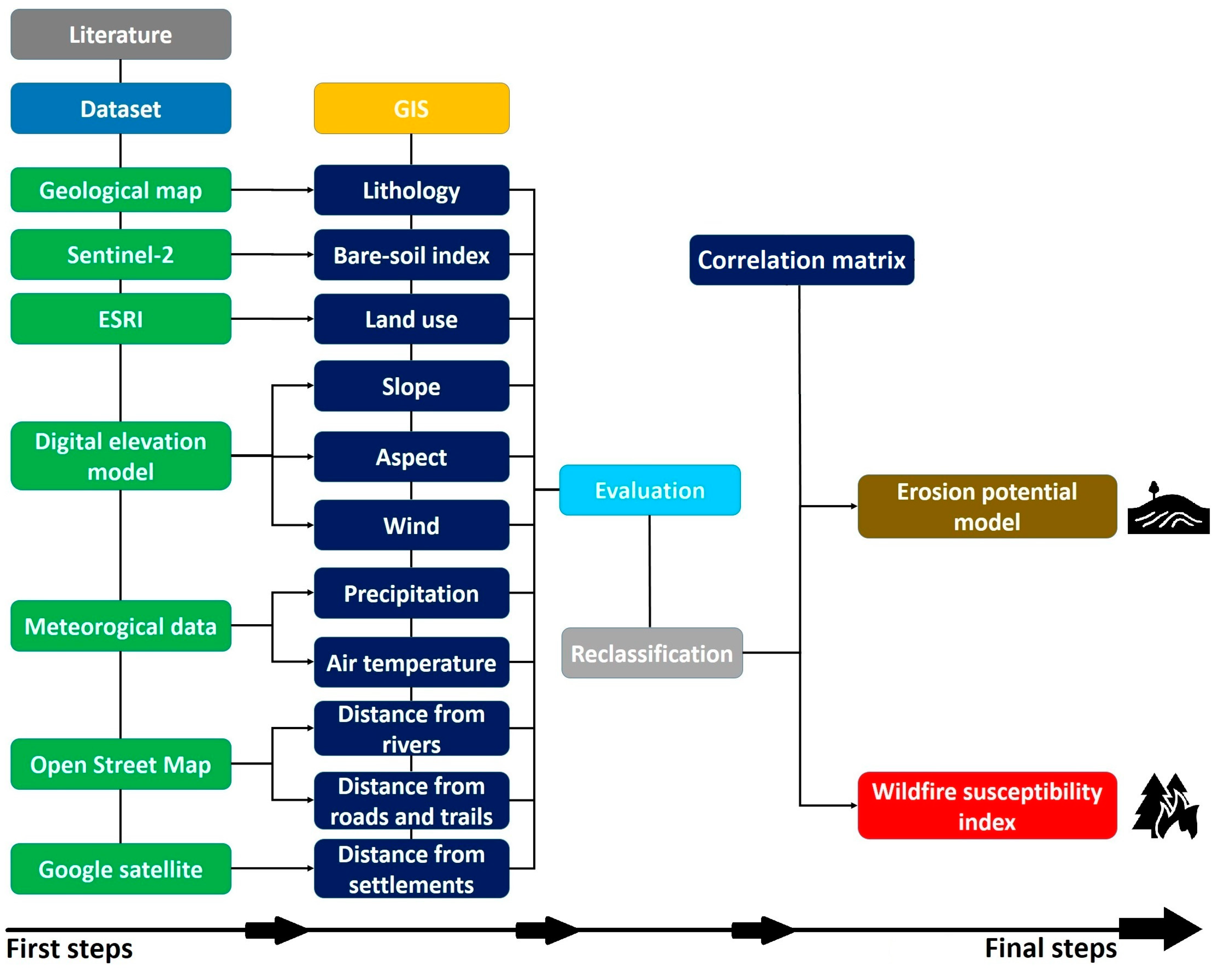
2.3. Methodology
2.3.1. Erosion Potential Model (EPM)
2.3.2. Wildfire Susceptibility Index (WSI)
3. Results
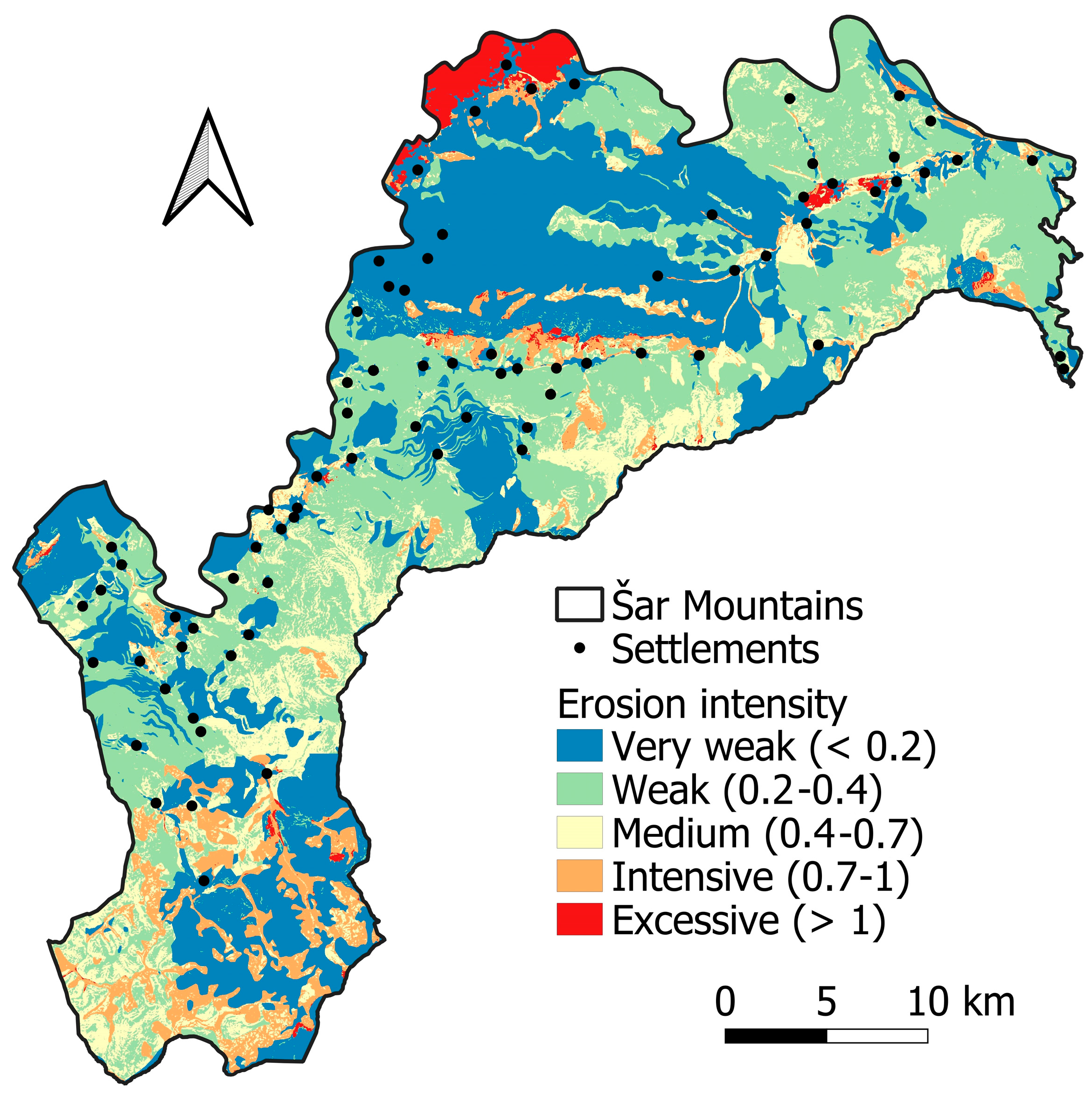
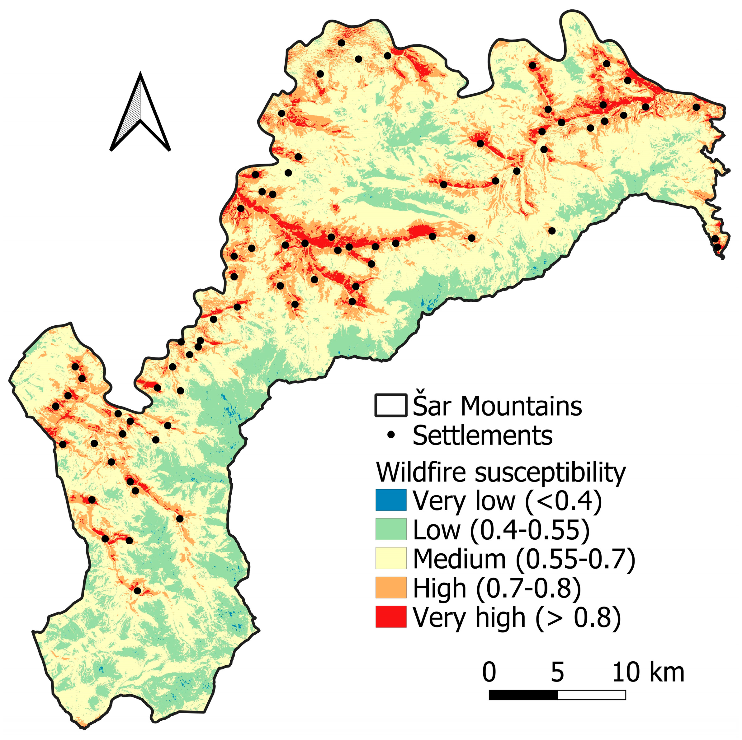
3.1. Spatial Analysis of Erosion Intensity and Wildfire Susceptibility
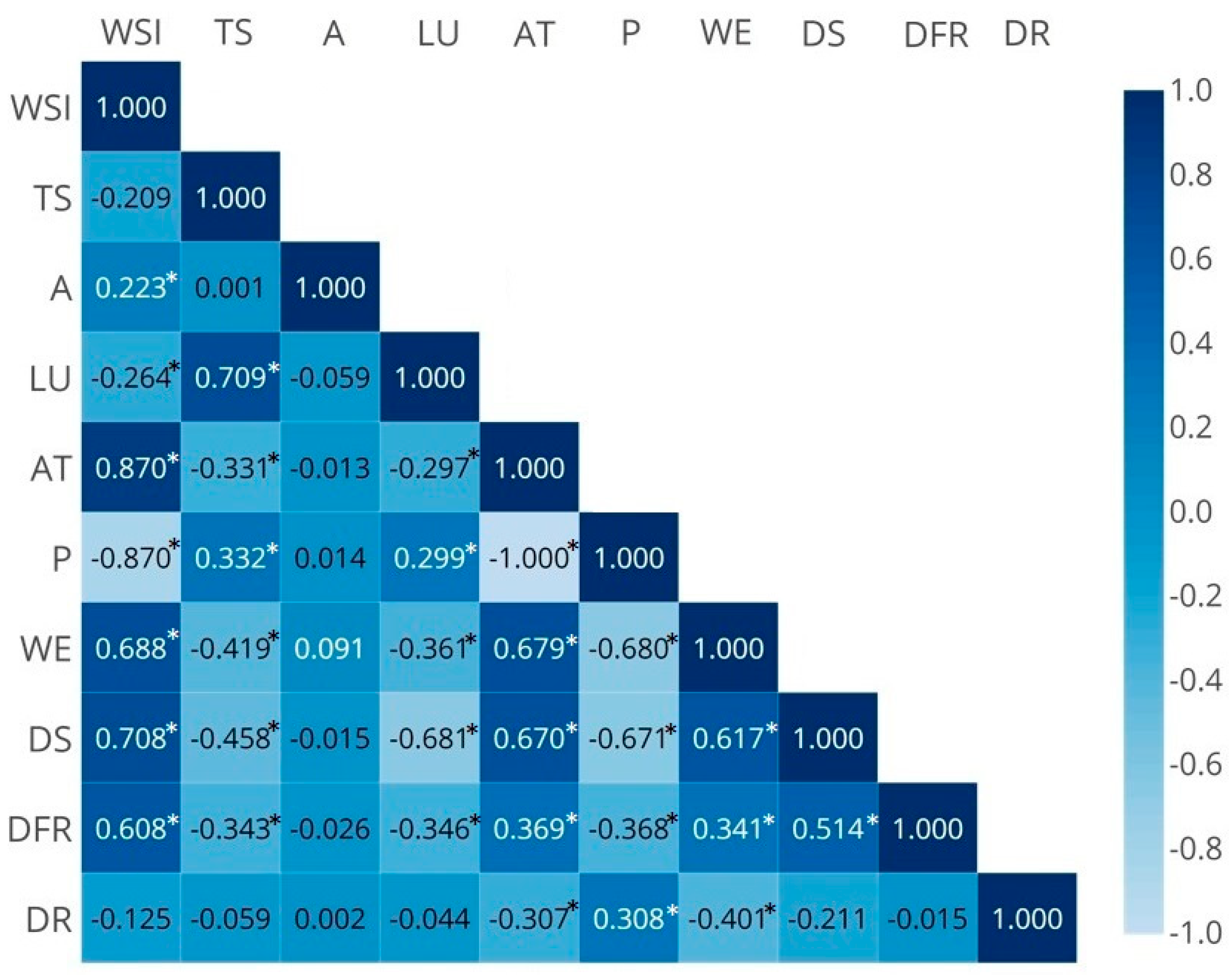
3.2. Determination of Control Indicators–The Impact of Selected Criteria
4. Discussion
5. Conclusions
Author Contributions
Funding
Data Availability Statement
Acknowledgments
Conflicts of Interest
References
- Cremen, G.; Galasso, C.; McCloskey, J. Modelling and quantifying tomorrow’s risks from natural hazards. Sci. Total Environ. 2022, 817, 152552. [Google Scholar] [CrossRef] [PubMed]
- Deđanski, V.; Durlević, U.; Kovjanić, A.; Lukić, T. GIS-Based Spatial Modeling of Landslide Susceptibility Using BWM-LSI: A Case Study—City of Smederevo (Serbia). Open Geosci. 2024, 16, 20220688. [Google Scholar] [CrossRef]
- Lukić, T.; Marić, P.; Hrnjak, I.; Gavrilov, M.B.; Mladjan, D.; Zorn, M.; Komac, B.; Milošević, Z.; Marković, S.B.; Sakulski, D.; et al. Forest fire analysis and classification based on Serbian case study. Acta Geogr. Slov. 2017, 57, 51–63. [Google Scholar] [CrossRef]
- Srejić, T.; Manojlović, S.; Sibinović, M.; Bajat, B.; Novković, I.; Milošević, M.V.; Carević, I.; Todosijević, M.; Sedlak, M.G. Agricultural Land Use Changes as a Driving Force of Soil Erosion in the Velika Morava River Basin, Serbia. Agriculture 2023, 13, 778. [Google Scholar] [CrossRef]
- Hou, D.; Bolan, N.; Tsang, D.; Kirkham, M.; O’Connor, D. Sustainable soil use and management: An interdisciplinary and systematic approach. Sci. Total Environ. 2020, 729, 138961. [Google Scholar] [CrossRef] [PubMed]
- Keesstra, S.D.; Bouma, J.; Wallinga, J.; Tittonell, P.; Smith, P.; Cerdà, A.; Montanarella, L.; Quinton, J.; Pachepsky, Y.; Van der Puten, W. The significance of soils and soil science towards realization of the United Nations Sustainable Development Goals. Soil 2016, 2, 111–128. [Google Scholar] [CrossRef]
- Lal, R. Soil erosion and the global carbon budget. Environ. Int. 2003, 29, 437–450. [Google Scholar] [CrossRef]
- Poesen, J. Soil erosion in the Anthropocene: Research needs. Earth Surf. Process. Landf. 2018, 43, 64–84. [Google Scholar] [CrossRef]
- Borrelli, P.; Alewell, C.; Alvarez, P.; Anache, J.; Baartman, J.; Ballabio, C.; Bezak, N.; Biddoccu, M.; Cerda, A.; Chalise, D. Soil erosion modelling: A global review and statistical analysis. Sci. Total Environ. 2021, 780, 146494. [Google Scholar] [CrossRef]
- Di Bene, C.; Francaviglia, R.; Farina, R.; Álvaro-Fuentes, J.; Zornoza, R. Agricultural Diversification. Agriculture 2022, 12, 369. [Google Scholar] [CrossRef]
- Pimentel, D.; Harvey, C.; Resosudarmo, P.; Sinclair, K.; Kurz, D.; Mcnair, M.; Crist, S.; Shpritz, L.; Fitton, L.; Saffouri, R.; et al. Environmental and Economic Costs of Soil Erosion and Conservation Benefits. Science 1995, 267, 1117–1123. [Google Scholar] [CrossRef] [PubMed]
- Altobelli, F.; Vargas, R.; Corti, G.; Dazzi, C.; Montanarella, L.; Monteleone, A.; Caon, L.; Piazza, M.; Calzolari, C.; Munafò, M.; et al. Improving soil and water conservation and ecosystem services by sustainable soil management practices: From a global to an Italian soil partnership. Ital. J. Agron. 2020, 15, 1765. [Google Scholar] [CrossRef]
- Lal, R. Accelerated Soil Erosion as a Source of Atmospheric CO2. Soil Till. Res. 2019, 188, 35–40. [Google Scholar] [CrossRef]
- Li, Z.Y.; Fang, H.Y. Impacts of Climate Change on Water Erosion: A Review. Earth Sci. Rev. 2016, 163, 94–117. [Google Scholar] [CrossRef]
- Ma, X.; Zhao, C.; Zhu, J. Aggravated Risk of Soil Erosion with Global Warming—A Global Meta-Analysis. Catena 2021, 200, 105129. [Google Scholar] [CrossRef]
- Golosov, V.; Yermolaev, O.; Litvin, L.; Chizhikova, N.; Kiryukhina, Z.; Safina, G. Influence of Climate and Land Use Changes on Recent Trends of Soil Erosion Rates within the Russian Plain. Land Degrad. Dev. 2018, 29, 2658–2667. [Google Scholar] [CrossRef]
- Bento-Gonçalves, A.; Vieira, A.; Santos, S.M.d. Research on Wildfires, Soil Erosion and Land Degradation in the XXI Century. Fire 2024, 7, 327. [Google Scholar] [CrossRef]
- Gavrilović, S. Engineering of Torrents and Erosion. J. Constr. 1972, 1–292. (In Serbian) [Google Scholar]
- Tošić, R.; Dragićević, S.; Lovrić, N. Assessment of Soil Erosion and Sediment Yield Changes Using Erosion Potential Model—Case Study: Republic of Srpska (BiH). CJEES 2012, 7, 147–154. [Google Scholar]
- Raza, A.; Ahrends, H.; Habib-Ur-Rahman, M.; Gaiser, T. Modeling Approaches to Assess Soil Erosion by Water at the Field Scale with Special Emphasis on Heterogeneity of Soils and Crops. Land 2021, 10, 422. [Google Scholar] [CrossRef]
- Dragićević, S.; Kostadinov, S.; Novković, I.; Momirović, N.; Langović, M.; Stefanović, T.; Radović, M.; Tošić, R. Assessment of Soil Erosion and Torrential Flood Susceptibility: Case Study—Timok River Basin, Serbia. In The Lower Danube River: Hydro-Environmental Issues and Sustainability; Springer International Publishing: Cham, Switzerland, 2022; pp. 357–380. [Google Scholar] [CrossRef]
- Polovina, S.; Radić, B.; Ristić, R.; Milčanović, V. Application of Remote Sensing for Identifying Soil Erosion Processes on a Regional Scale: An Innovative Approach to Enhance the Erosion Potential Model. Remote Sens. 2024, 16, 2390. [Google Scholar] [CrossRef]
- Bezak, N.; Borrelli, P.; Mikoš, M.; Jemec Auflič, M.; Panagos, P. Towards Multi-Model Soil Erosion Modelling: An Evaluation of the Erosion Potential Method (EPM) for Global Soil Erosion Assessments. Catena 2024, 234, 107596. [Google Scholar] [CrossRef]
- Dominici, R.; Larosa, S.; Viscomi, A.; Mao, L.; De Rosa, R.; Cianflone, G. Yield Erosion Sediment (YES): A PyQGIS Plug-in for the Sediments Production Calculation Based on the Erosion Potential Method. Geosciences 2020, 10, 324. [Google Scholar] [CrossRef]
- Elaloui, A.; Khalki, E.M.E.; Namous, M.; Ziadi, K.; Eloudi, H.; Faouzi, E.; Bou-Imajjane, L.; Karroum, M.; Tramblay, Y.; Boudhar, A.; et al. Soil Erosion under Future Climate Change Scenarios in a Semi-Arid Region. Water 2022, 15, 146. [Google Scholar] [CrossRef]
- Sakuno, N.R.R.; Guiçardi, A.C.F.; Spalevic, V.; Avanzi, J.C.; Silva, M.L.N.; Mincato, R.L. Adaptation and Application of the Erosion Potential Method for Tropical Soils. Rev. Ciência Agronômica 2020, 51, e20186545. [Google Scholar] [CrossRef]
- Djurdjić, S.; Jakovljević, T. Possibilities and Challenges of Cross-Border Cooperation in the Field of Environmental Protection. In Proceedings of the Tenth Scientific-Professional Meeting with International Participation “Local Self-Government in Planning and Arrangement of Space and Settlements”, Pirot, Serbia, 17–19 October 2024; pp. 63–69. (In Serbian). [Google Scholar]
- Dragićević, S.; Mészáros, M.; Djurdjić, S.; Pavić, D.; Novković, I.; Tošić, R. Vulnerability of National Parks to Natural Hazards in the Serbian Danube Region. Pol. J. Environ. Stud. 2013, 22, 1053–1060. [Google Scholar]
- Durlević, U.; Novković, I.; Lukić, T.; Valjarević, A.; Samardžić, I.; Krstić, F.; Batoćanin, N.; Mijatov, M.; Ćurić, V. Multihazard Susceptibility Assessment: A Case Study—Municipality of Štrpce (Southern Serbia). Open Geosci. 2021, 13, 1414–1431. [Google Scholar] [CrossRef]
- Novkovic, I.; Marković, G.B.; Lukić, D.; Dragićević, S.; Milošević, M.; Djurdjić, S.; Samardžić, I.; Lezaic, T.; Tadić, M. GIS-Based Forest Fire Susceptibility Zonation with IoT Sensor Network Support, Case Study—Nature Park Golija, Serbia. Sensors 2021, 21, 6520. [Google Scholar] [CrossRef]
- Lukić, D.; Perić, M.; Stankov, S. GIS-AHP Multi Criteria Nature Protection Vulnerability Evaluation Method: A Case Study of Tara National Park, Serbia. Fresenius Environ. Bull. 2023, 32, 2954–2964. [Google Scholar]
- Živanović, S.; Gocić, M.; Tošić, I. Vulnerability of Central Serbian National Parks to Wildfires. Időjárás 2024, 128, 99–120. [Google Scholar] [CrossRef]
- Li, J.; Shan, Y.; Yin, S.; Wang, M.; Sun, L.; Wang, D. Nonparametric Multivariate Analysis of Variance for Affecting Factors on the Extent of Wildfire Damage in Jilin Province, China. J. For. Res. 2019, 30, 2185–2197. [Google Scholar] [CrossRef]
- Zema, D.A.; Nunes, J.P.; Lucas-Borja, M.E. Improvement of Seasonal Runoff and Soil Loss Predictions by the MMF (Morgan-Morgan-Finney) Model after Wildfire and Soil Treatment in Mediterranean Forest Ecosystems. Catena 2020, 188, 104415. [Google Scholar] [CrossRef]
- Das, J.; Mahato, S.; Joshi, P.K.; Liou, Y.-A. Forest Fire Susceptibility Zonation in Eastern India Using Statistical and Weighted Modelling Approaches. Remote Sens. 2023, 15, 1340. [Google Scholar] [CrossRef]
- Bjånes, A.; Fuente, L.D.R.; Mena, P. A Deep Learning Ensemble Model for Wildfire Susceptibility Mapping. Ecol. Inform. 2021, 65, 101397. [Google Scholar] [CrossRef]
- Bahadori, N.; Razavi-Termeh, S.V.; Sadeghi-Niaraki, A.; Al-Kindi, K.M.; Abuhmed, T.; Nazeri, B.; Choi, S.-M. Wildfire Susceptibility Mapping Using Deep Learning Algorithms in Two Satellite Imagery Datasets. Forests 2023, 14, 1325. [Google Scholar] [CrossRef]
- Aleksova, B.; Lukić, T.; Milevski, I.; Puhar, D.; Marković, S.B. Preliminary Assessment of Geohazards’ Impacts on Geodiversity in the Kratovska Reka Catchment (North Macedonia). Geosciences 2024, 14, 62. [Google Scholar] [CrossRef]
- Erten, E.; Kurgun, V.; Musaoğlu, N. Forest Fire Risk Zone Mapping from Satellite Imagery and GIS: A Case Study. In Proceedings of the XX Congress of the International Society for Photogrammetry and Remote Sensing, Istanbul, Turkey, 12–23 July 2004; pp. 33–39. [Google Scholar]
- Turco, M.; Rosa-Cánovas, J.J.; Bedia, J.; Jerez, S.; Montávez, J.P.; Llasat, M.C.; Provenzale, A. Exacerbated Fires in Mediterranean Europe Due to Anthropogenic Warming Projected with Non-Stationary Climate-Fire Models. Nat. Commun. 2018, 9, 3821. [Google Scholar] [CrossRef]
- Feurdean, A.; Vannière, B.; Finsinger, W.; Warren, D.; Connor, S.C.; Forrest, M.; Liakka, J.; Panait, A.; Werner, C.; Andrič, M.; et al. Fire Hazard Modulation by Long-Term Dynamics in Land Cover and Dominant Forest Type in Eastern and Central Europe. Biogeosciences 2020, 17, 1213–1230. [Google Scholar] [CrossRef]
- Costa, H.; de Rigo, D.; Libertà, G.; Durrant, T.; San-Miguel-Ayanz, J. European Wildfire Danger and Vulnerability under a Changing Climate: Towards Integrating Risk Dimensions; EUR 30116 EN; Publications Office of the European Union: Luxembourg, 2020. [Google Scholar] [CrossRef]
- Gigović, L.; Pourghasemi, H.R.; Drobnjak, S.; Bai, S. Testing a New Ensemble Model Based on SVM and Random Forest in Forest Fire Susceptibility Assessment and Its Mapping in Serbia’s Tara National Park. Forests 2019, 10, 408. [Google Scholar] [CrossRef]
- Thuiller, W.; Lavorel, S.; Araújo, M.B.; Sykes, M.T. Climate Change Threats to Plant Diversity in Europe. Proc. Natl. Acad. Sci. USA 2005, 102, 8245–8250. [Google Scholar] [CrossRef]
- Milanović, S.; Marković, N.; Pamučar, D.; Gigović, L.; Kostić, P.; Milanović, S.D. Forest Fire Probability Mapping in Eastern Serbia: Logistic Regression versus Random Forest Method. Forests 2021, 12, 5. [Google Scholar] [CrossRef]
- Demir, A.; Akay, A.E. Forest Fire Risk Mapping Using GIS-Based Analytical Hierarchy Process Approach. Eur. J. For. Eng. 2024, 10, 15–28. [Google Scholar] [CrossRef]
- Dong, X.; Li-min, D.; Guo-fan, S.; Lei, T.; Hui, W. Forest Fire Risk Zone Mapping from Satellite Images and GIS for Baihe Forestry Bureau, Jilin, China. J. For. Res. 2005, 16, 169–174. [Google Scholar] [CrossRef]
- Tiwari, A.; Shoab, M.; Dixit, A. GIS-Based Forest Fire Susceptibility Modeling in Pauri Garhwal, India: A Comparative Assessment of Frequency Ratio, Analytic Hierarchy Process and Fuzzy Modeling Techniques. Nat. Hazards 2021, 105, 1189–1230. [Google Scholar] [CrossRef]
- Pourghasemi, H.R.; Beheshtirad, M.; Pradhan, B. A Comparative Assessment of Prediction Capabilities of Modified Analytical Hierarchy Process (M-AHP) and Mamdani Fuzzy Logic Models using Netcad-GIS for Forest Fire Susceptibility Mapping. Geomat. Nat. Hazards Risk 2016, 7, 861–885. [Google Scholar] [CrossRef]
- QGIS Development Team. QGIS Geographic Information System v3.28.10 with GRASS. Open Source Geospatial Foundation Project. 2023. Available online: http://qgis.osgeo.org (accessed on 18 June 2023).
- Nikolić, G.; Vujović, F.; Golijanin, J.; Šiljeg, A.; Valjarević, A. Modelling of Wildfire Susceptibility in Different Climate Zones in Montenegro Using GIS-MCDA. Atmosphere 2023, 14, 929. [Google Scholar] [CrossRef]
- Ćurić, V.; Durlević, U.; Ristić, N.; Novković, I.; Čegar, N. GIS Application in Analysis of Threat of Forest Fires and Landslides in the Svrljiški Timok Basin (Serbia). Bull. Serbian Geograph. Soc. 2022, 102, 107–130. [Google Scholar] [CrossRef]
- Durlević, U.; Novković, I.; Bajić, S.; Milinčić, M.; Valjarević, A.; Čegar, N.; Lukić, T. Snow Avalanche Hazard Prediction Using the Best-Worst Method—Case Study: The Šar Mountains, Serbia. In Advances in Best-Worst Method; Rezaei, J., Brunelli, M., Mohammadi, M., Eds.; Springer: Cham, Switzerland, 2023; pp. 211–216. [Google Scholar] [CrossRef]
- Stojković, S.; Marković, D.; Durlević, U. Snow Cover Estimation Using Sentinel-2 High Spatial Resolution Data: A Case Study: National Park Šar Planina (Serbia). In Advanced Technologies, Systems, and Applications VII; Ademović, N., Mujčić, E., Mulić, M., Kevrić, J., Akšamija, Z., Eds.; Springer: Cham, Switzerland, 2023; pp. 507–519. [Google Scholar] [CrossRef]
- Durlević, U.; Valjarević, A.; Novković, I.; Ćurčić, N.B.; Smiljić, M.; Morar, C.; Stoica, A.; Barišić, D.; Lukić, T. GIS-Based Spatial Modeling of Snow Avalanches Using Analytic Hierarchy Process: A Case Study of the Šar Mountains, Serbia. Atmosphere 2022, 13, 1229. [Google Scholar] [CrossRef]
- Institute of Nature Conservation of Serbia. Protected Areas, National Park Šar Planina. 2024. Available online: https://zzps.rs (accessed on 23 February 2024).
- Durlević, U.; Valjarević, A.; Novković, I.; Vujović, F.; Josifov, N.; Krušić, J.; Komac, B.; Đekić, T.; Singh, S.K.; Jović, G.; et al. Universal Snow Avalanche Modeling Index Based on SAFI–Flow-R Approach in Poorly-Gauged Regions. ISPRS Int. J. Geo-Inf. 2024, 13, 315. [Google Scholar] [CrossRef]
- Aleksova, B.; Milevski, I.; Dragićević, S.; Lukić, T. GIS-Based Integrated Multi-Hazard Vulnerability Assessment in Makedonska Kamenica Municipality, North Macedonia. Atmosphere 2024, 15, 774. [Google Scholar] [CrossRef]
- Tošić, R.; Dragićević, S. Chronological Development of the Erosion Potential Method; Serbian Geographical Society: Belgrade, Serbia, 2024. (In Serbian) [Google Scholar]
- Geoliss. Basic Geological Map of Former Yugoslavia. 1979. Available online: https://geoliss.mre.gov.rs/prez/OGK/RasterSrbija/ (accessed on 9 February 2024).
- Environmental Systems Research Institute [ESRI]. Sentinel-2 Land Cover Explorer. 2023. Available online: https://livingatlas.arcgis.com/landcoverexplorer/#mapCenter=21.076%2C42.197%2C13&mode=step&timeExtent=2017%2C2023&year=2023 (accessed on 12 February 2024).
- Stefanidis, S.; Mallinis, G.; Alexandridis, V. Multi-Decadal Monitoring of Soil Erosion Rates in South Europe. Environ. Sci. Proc. 2023, 26, 138. [Google Scholar] [CrossRef]
- Durlević, U.; Momčilović, A.; Ćurić, V.; Dragojević, M. GIS Application in Analysis of Erosion Intensity in the Vlasina River Basin. Bull. Serbian Geograph. Soc. 2019, 99, 17–36. [Google Scholar] [CrossRef]
- Sivrikaya, F.; Sağlam, B.; Akay, A.E.; Bozali, N. Evaluation of Forest Fire Risk with GIS. Pol. J. Environ. Stud. 2014, 23, 187–194. [Google Scholar]
- Alaska Satellite Facility. ALOS PALSAR. 2006. Available online: https://search.asf.alaska.edu/#/ (accessed on 10 February 2024).
- Nguyen, C.T.; Chidthaisong, A.; Kieu Diem, P.; Huo, L.-Z. A Modified Bare Soil Index to Identify Bare Land Features During Agricultural Fallow-Period in Southeast Asia Using Landsat 8. Land 2021, 10, 231. [Google Scholar] [CrossRef]
- Diek, S.; Fornallaz, F.; Schaepman, M.; De Jong, R. Barest Pixel Composite for Agricultural Areas Using Landsat Time Series. Remote Sens. 2017, 9, 1245. [Google Scholar] [CrossRef]
- Iban, M.C.; Aksu, O. SHAP-Driven Explainable Artificial Intelligence Framework for Wildfire Susceptibility Mapping Using MODIS Active Fire Pixels: An In-Depth Interpretation of Contributing Factors in Izmir, Türkiye. Remote Sens. 2024, 16, 2842. [Google Scholar] [CrossRef]
- Živanović, S.; Gocić, M. Forest Fires in Serbia—Influence of Humidity Conditions. J. Geogr. Inst. Cvijic 2022, 72, 221–228. [Google Scholar] [CrossRef]
- Yu, Q.; Zhao, Y.; Yin, Z.; Xu, Z. Wildfire Susceptibility Prediction Based on a CA-Based CCNN with Active Learning Optimization. Fire 2024, 7, 201. [Google Scholar] [CrossRef]
- Rozas, H.; Xie, W.; Gebraeel, N. Condition-Based Maintenance for Wind Farms Using a Distributionally Robust Chance Constrained Program. IEEE Trans. Power Syst. 2025, 40, 231–243. [Google Scholar] [CrossRef]
- Abouali, A.; Viegas, X.D.; Raposo, R.J. Analysis of the Wind Flow and Fire Spread Dynamics over a Sloped–Ridgeline Hill. Combust. Flame 2021, 234, 111724. [Google Scholar] [CrossRef]
- Francos, M.; Colino-Prieto, F.; Sánchez-García, C. How Mediterranean Ecosystem Deals with Wildfire Impact on Soil Ecosystem Services and Functions: A Review. Land 2024, 13, 407. [Google Scholar] [CrossRef]
- Florath, J.; Chanussot, J.; Keller, S. Road Accessibility during Natural Hazards Based on Volunteered Geographic Information Data and Network Analysis. ISPRS Int. J. Geo-Inf. 2024, 13, 107. [Google Scholar] [CrossRef]
- Open Street Map. Data Export. 2023. Available online: https://www.openstreetmap.org/export#map=4/48.89/29 (accessed on 25 June 2023).
- Yue, W.; Ren, C.; Liang, Y.; Liang, J.; Lin, X.; Yin, A.; Wei, Z. Assessment of Wildfire Susceptibility and Wildfire Threats to Ecological Environment and Urban Development Based on GIS and Multi-Source Data: A Case Study of Guilin, China. Remote Sens. 2023, 15, 2659. [Google Scholar] [CrossRef]
- Dai, T.; Wang, L.; Li, T.; Qiu, P.; Wang, J. Study on the Characteristics of Soil Erosion in the Black Soil Area of Northeast China under Natural Rainfall Conditions: The Case of Sunjiagou Small Watershed. Sustainability 2022, 14, 8284. [Google Scholar] [CrossRef]
- Baharvand, S.; Pradhan, B. Erosion and Flood Susceptibility Evaluation in a Catchment of Kopet-Dagh Mountains Using EPM and RFM in GIS. Environ. Earth Sci. 2022, 81, 490. [Google Scholar] [CrossRef]
- Salma, K.; Ahmed, A.; Abdellah, A.; Salma, E. Estimation and mapping of water erosion and soil loss: Application of Gavrilovic erosion potential model (EPM) using GIS and remote sensing in the Assif el mal Watershed, Western high Atlas. China Geol. 2024, 7, 672–685. [Google Scholar] [CrossRef]
- Lazarević, R. Erosion in Serbia. Belgrade Želnid 2009, 1–294. (In Serbian) [Google Scholar]
- Milevski, I.; Aleksova, B.; Lukić, T.; Dragićević, S.; Valjarević, A. Multi-Hazard Modeling of Erosion and Landslide Susceptibility at the National Scale in the Example of North Macedonia. Open Geosci. 2024, 16, 20220718. [Google Scholar] [CrossRef]
- Kostadinov, S.; Braunović, S.; Dragićević, S.; Zlatić, M.; Dragović, N.; Rakonjac, N. Effects of Erosion Control Works: Case Study—Grdelica Gorge, the South Morava River (Serbia). Water 2018, 10, 1094. [Google Scholar] [CrossRef]
- Petrović, A.M.; Manojlović, S.; Srejić, T.; Zlatanović, N. Insights into Land-Use and Demographical Changes: Runoff and Erosion Modifications in the Highlands of Serbia. Land 2024, 13, 1342. [Google Scholar] [CrossRef]
- Ouallali, A.; Kader, S.; Bammou, Y.; Aqnouy, M.; Courba, S.; Beroho, M.; Briak, H.; Spalevic, V.; Kuriqi, A.; Hysa, A. Assessment of the Erosion and Outflow Intensity in the Rif Region under Different Land Use and Land Cover Scenarios. Land 2024, 13, 141. [Google Scholar] [CrossRef]
- Srejić, T.; Manojlović, S.; Kričković, E. Spatial Differentiation of the Intensity of Soil Erosion According to Predominant Geographical Factors in the Municipality of Rekovac. In Proceedings—VI Congress of Geographers of Serbia with International Participation; University of Belgrade: Belgrade, Serbia, 2024; pp. 103–111. (In Serbian) [Google Scholar]
- Manojlović, S. Influence of Geographical Factors on Changes in the Intensity of Water Erosion in the Nišava River Basin; University of Belgrade, Faculty of Geography: Belgrade, Serbia, 2019. (In Serbian) [Google Scholar]
- Elbadaoui, K.; Mansour, S.; Ikirri, M.; Abdelrahman, K.; Abu-Alam, T.; Abioui, M. Integrating Erosion Potential Model (EPM) and PAP/RAC Guidelines for Water Erosion Mapping and Detection of Vulnerable Areas in the Toudgha River Watershed of the Central High Atlas, Morocco. Land 2023, 12, 837. [Google Scholar] [CrossRef]
- Yesuph, A.Y.; Dagnew, A.B. Soil Erosion Mapping and Severity Analysis Based on RUSLE Model and Local Perception in the Beshillo Catchment of the Blue Nile Basin, Ethiopia. Environ. Syst. Res. 2019, 8, 17. [Google Scholar] [CrossRef]
- Attoubounou, R.A.; Diawara, H.; Ludwig, R.; Adounkpe, J. Quantification of Soil–Water Erosion Using the RUSLE Method in the Mékrou Watershed (Middle Niger River). ISPRS Int. J. Geo-Inf. 2025, 14, 28. [Google Scholar] [CrossRef]
- Fire Information for Resource Management System [FIRMS]. Archive Download. 2025. Available online: https://firms.modaps.eosdis.nasa.gov/download/ (accessed on 15 February 2025).
- Dragićević, S.; Pripužić, M.; Živković, N.; Novković, I.; Kostadinov, S.; Langović, M.; Milojković, B.; Čvorović, Z. Spatial and Temporal Variability of Bank Erosion during the Period 1930–2016: Case Study—Kolubara River Basin (Serbia). Water 2017, 9, 748. [Google Scholar] [CrossRef]
- Santi, P.M.; Rengers, F.K. 9.32—Wildfire and Landscape Change. In Treatise on Geomorphology, 2nd ed.; Jack, J., Shroder, F., Eds.; Academic Press: San Diego, CA, USA, 2022; pp. 765–797. [Google Scholar]
- Dow, H.W.; East, A.E.; Sankey, J.B.; Warrick, J.A.; Kostelnik, J.; Lindsay, D.N.; Kean, J.W. Postfire sediment mobilization and its downstream implications across California, 1984–2021. J. Geophys. Res. Earth Surf. 2024, 129, e2024JF007725. [Google Scholar] [CrossRef]
- Shakesby, R. Post-wildfire soil erosion in the Mediterranean: Review and future research directions. Earth Sci. Rev. 2011, 105, 71–100. [Google Scholar] [CrossRef]
- Manojlović, S.; Sibinović, M.; Srejić, T.; Novković, I.; Milošević, M.V.; Gatarić, D.; Carević, I.; Batoćanin, N. Factors Controlling the Change of Soil Erosion Intensity in Mountain Watersheds in Serbia. Front. Environ. Sci. 2022, 10, 888901. [Google Scholar] [CrossRef]
- Potić, I.M.; Ćurčić, N.B.; Radovanović, M.M.; Stanojević, G.B.; Malinović-Milićević, S.B.; Yamashkin, S.A.; Yamashkin, A.A. Estimation of Soil Erosion Dynamics Using Remote Sensing and SWAT in Kopaonik National Park, Serbia. J. Geogr. Inst. Cvijic 2021, 71, 231–247. [Google Scholar] [CrossRef]
- Ristić, R.; Vasiljević, N.; Radić, B.; Radivojević, S. Degradation of Landscape in Serbian Ski Resorts: Aspects of Scale and Transfer of Impacts. SPATIUM Int. Rev. 2009, 20, 49–52. [Google Scholar] [CrossRef]
- Živanović, S.; Tošić, I. Influence of Climatic Conditions on Fire Risk in Djerdap National Park (Serbia): A Case Study of September 2011. Therm. Sci. 2020, 24, 2845–2855. [Google Scholar] [CrossRef]
- Malušević, I.; Ristić, R.; Radić, B.; Polovina, S.; Milčanović, V.; Nešković, P. A Historical Overview of Methods for the Estimation of Erosion Processes on the Territory of the Republic of Serbia. Land 2025, 14, 405. [Google Scholar] [CrossRef]
- Alsaihani, M.; Alharbi, R. Mapping of Soil Erosion Vulnerability in Wadi Bin Abdullah, Saudi Arabia through RUSLE and Remote Sensing. Water 2024, 16, 2663. [Google Scholar] [CrossRef]
- Nieto, C.E.; Martínez-Graña, A.M.; Merchán, L. Soil Erosion Risk Analysis in the Ría de Arosa (Pontevedra, Spain) Using the RUSLE and GIS Techniques. Forests 2024, 15, 1481. [Google Scholar] [CrossRef]
- Erdoğan Yüksel, E.; Karan, Ö.F.; Akay, A.E. Spatio-Temporal Analysis of Erosion Risk Assessment Using GIS-Based AHP Method: A Case Study of Doğancı Dam Watershed in Bursa (Türkiye). Forests 2024, 15, 1135. [Google Scholar] [CrossRef]
- Bao, M.; Liu, J.; Ren, H.; Liu, S.; Ren, C.; Chen, C.; Liu, J. Research Trends in Wildland Fire Prediction Amidst Climate Change: A Comprehensive Bibliometric Analysis. Forests 2024, 15, 1197. [Google Scholar] [CrossRef]
- Zhang, T.; Wang, D.; Lu, Y. A Dynamic Spatiotemporal Understanding of Changes in Social Vulnerability to Wildfires at Local Scale. Fire 2024, 7, 251. [Google Scholar] [CrossRef]
- Shin, S.S.; Park, S.D.; Kim, G. Applicability Comparison of GIS-Based RUSLE and SEMMA for Risk Assessment of Soil Erosion in Wildfire Watersheds. Remote Sens. 2024, 16, 932. [Google Scholar] [CrossRef]
- Radovanović, M.; Pereira Gomes, J.F.; Yamashkin, A.A.; Milenković, M.; Stevančević, M. Electrons or Protons: What Is the Cause of Forest Fires in Western Europe on June 18, 2017? J. Geogr. Inst. “Jovan Cvijić” SASA 2017, 67, 213–218. [Google Scholar] [CrossRef]
- Čupić, A.; Smičiklas, I.; Manić, M.; Đokić, M.; Dragović, R.; Đorđević, M.; Gocić, M.; Jović, M.; Topalović, D.; Gajić, B.; et al. 137Cs-Based Assessment of Soil Erosion Rates in a Morphologically Diverse Catchment with Varying Soil Types and Vegetation Cover: Relationship with Soil Properties and RUSLE Model Predictions. Water 2025, 17, 526. [Google Scholar] [CrossRef]
- Nur, A.S.; Kim, Y.J.; Lee, J.H.; Lee, C.-W. Spatial Prediction of Wildfire Susceptibility Using Hybrid Machine Learning Models Based on Support Vector Regression in Sydney, Australia. Remote Sens. 2023, 15, 760. [Google Scholar] [CrossRef]
- Milenković, M.; Ducić, V.; Obradović, D.; Dedić, A.; Burić, D. Climatic and Anthropogenic Impacts on Forest Fires in Conditions of Extreme Fire Danger on Sandy Soils. J. Geogr. Inst. “Jovan Cvijić” SASA 2023, 73, 155–168. [Google Scholar] [CrossRef]
- Falaras, T.; Tselka, I.; Papadopoulos, I.; Nikolidaki, M.; Karavias, A.; Bafi, D.; Petani, A.; Krassakis, P.; Parcharidis, I. Operational Mapping and Post-Disaster Hazard Assessment by the Development of a Multiparametric Web App Using Geospatial Technologies and Data: Attica Region 2021 Wildfires (Greece). Appl. Sci. 2022, 12, 7256. [Google Scholar] [CrossRef]
- Đokić, M.; Manić, M.; Đorđević, M.; Gocić, M.; Čupić, A.; Jović, M.; Dragović, R.; Gajić, B.; Smičiklas, I.; Dragović, S. Remote Sensing and Nuclear Techniques for High-Resolution Mapping and Quantification of Gully Erosion in the Highly Erodible Area of the Malčanska River Basin, Eastern Serbia. Environ. Res. 2023, 235, 116679. [Google Scholar] [CrossRef] [PubMed]
- Manić, M.; Đorđević, M.; Đokić, M.; Dragović, R.; Kićović, D.; Đorđević, D.; Jović, M.; Smičiklas, I.; Dragović, S. Remote Sensing and Nuclear Techniques for Soil Erosion Research in Forest Areas: Case Study of the Crveni Potok Catchment. Front. Environ. Sci. 2022, 10, 897248. [Google Scholar] [CrossRef]
- González, F.; Morante-Carballo, F.; González, A.; Bravo-Montero, L.; Benavidez-Silva, C.; Tedim, F. Assessment of Forest Fire Severity for a Management Conceptual Model: Case Study in Vilcabamba, Ecuador. Forests 2024, 15, 2210. [Google Scholar] [CrossRef]
- Shin, S.S.; Park, S.D.; Kim, G. Risk Assessment of Soil Erosion Using a GIS-Based SEMMA in Post-Fire and Managed Watershed. Sustainability 2022, 14, 7339. [Google Scholar] [CrossRef]
- Dosis, S.; Petropoulos, G.P.; Kalogeropoulos, K. A Geospatial Approach to Identify and Evaluate Ecological Restoration Sites in Post-Fire Landscapes. Land 2023, 12, 2183. [Google Scholar] [CrossRef]
- Li, Y.; Wu, G.; Zhang, S.; Li, M.; Nie, B.; Chen, Z. A Novel Method of Modeling Grassland Wildfire Dynamics Based on Cellular Automata: A Case Study in Inner Mongolia, China. ISPRS Int. J. Geo-Inf. 2023, 12, 474. [Google Scholar] [CrossRef]
- Tzouveleki, M.; Hatzaki, M.; Antoniou, V.; Karali, A.; Giannakopoulos, C. Modelling Future Forest Fire Risk for the Tourism Sector of Crete. Environ. Sci. Proc. 2023, 26, 150. [Google Scholar] [CrossRef]
- Jo, H.-W.; Krasovskiy, A.; Hong, M.; Corning, S.; Kim, W.; Kraxner, F.; Lee, W.-K. Modeling Historical and Future Forest Fires in South Korea: The FLAM Optimization Approach. Remote Sens. 2023, 15, 1446. [Google Scholar] [CrossRef]
- Asensio, M.I.; Cascón, J.M.; Prieto-Herráez, D.; Ferragut, L. An Historical Review of the Simplified Physical Fire Spread Model PhyFire: Model and Numerical Methods. Appl. Sci. 2023, 13, 2035. [Google Scholar] [CrossRef]
- Tonini, M.; Pereira, M.G.; Fiorucci, P. Performance and Efficiency of Machine Learning Based Approaches for Wildfire Susceptibility Mapping. Environ. Sci. Proc. 2022, 17, 38. [Google Scholar] [CrossRef]


| Criteria | Parameter | Grade | Area (km2) | Share in Total Area (%) |
|---|---|---|---|---|
| Lithology | Diabase–chert formation | 0.25 | 134.94 | 13.86 |
| Scree | 2 | 1.74 | 0.18 | |
| Deluvium | 2 | 26.01 | 2.67 | |
| Igneous rocks | 0.2 | 60.91 | 6.26 | |
| Fluvio-glacial sediments | 1.8 | 29.94 | 3.07 | |
| Mesozoic clastic sediments | 1.8 | 1.79 | 0.18 | |
| Proluvium | 1.9 | 30.35 | 3.12 | |
| Alluvial sediments | 2 | 16.02 | 1.65 | |
| Metamorphic rocks | 0.9 | 465.23 | 47.78 | |
| Ultramafic | 0.35 | 25.39 | 2.61 | |
| Mesozoic carbonate sediments | 0.35 | 125.11 | 12.85 | |
| Pleistocene lacustrine sediments | 1.9 | 3.00 | 0.31 | |
| Moraine deposits | 1.8 | 49.95 | 5.13 | |
| Tertiary clastic sediments | 0.9 | 1.93 | 0.20 | |
| Flysch | 0.9 | 0.54 | 0.05 | |
| Thick rock debris | 0.2 | 0.87 | 0.09 | |
| Land use | Water surface | 0 | 0.03 | 0.003 |
| Forests | 0.25 | 431.78 | 44.34 | |
| Agricultural areas | 0.85 | 18.09 | 1.86 | |
| Built area | 0.05 | 36.23 | 3.72 | |
| Bare ground | 1 | 0.06 | 0.006 | |
| Snow | 0.3 | 0.02 | 0.002 | |
| Rangeland | 0.3 | 487.51 | 50.07 | |
| Bare-soil index | (BSI + 1) | From 0.67 to 1.21 | Overall | 100% |
| Terrain slope | Decimal slope | From 0 to 5.96 | Overall | 100% |
| Criteria | Parameter | Grade | Area (km2) | Share in Total Area (%) |
|---|---|---|---|---|
| Terrain slope (°) | 0–4 | 0.2 | 40.39 | 4.14 |
| 4–8 | 0.4 | 67.75 | 6.95 | |
| 8–12 | 0.6 | 111.67 | 11.46 | |
| 12–16 | 0.8 | 155.83 | 15.99 | |
| >16 | 1 | 599.05 | 61.46 | |
| Aspect | Unexposed | 0.9 | 3.28 | 0.34 |
| North | 0.1 | 163.47 | 16.79 | |
| Northeast | 0.2 | 133.98 | 13.76 | |
| East | 0.4 | 90.27 | 9.27 | |
| Southeast | 0.8 | 74.59 | 7.66 | |
| South | 1 | 90.21 | 9.26 | |
| Southwest | 0.9 | 113.26 | 11.63 | |
| West | 0.5 | 140.31 | 14.41 | |
| Northwest | 0.3 | 164.36 | 16.88 | |
| Land use | Water surface | 0 | 0.03 | 0.003 |
| Forests | 1 | 431.78 | 44.34 | |
| Agricultural areas | 0.6 | 18.09 | 1.86 | |
| Built area | 0.2 | 36.23 | 3.72 | |
| Bare ground | 0.1 | 0.06 | 0.006 | |
| Snow | 0 | 0.02 | 0.002 | |
| Rangeland | 0.9 | 487.51 | 50.07 | |
| Air temperature (°C) | <2.34 | 0.2 | 50.71 | 5.21 |
| 2.34–4.68 | 0.4 | 222.30 | 22.83 | |
| 4.68–7 | 0.6 | 295.21 | 30.32 | |
| 7–9.36 | 0.8 | 310.40 | 31.88 | |
| >9.36 | 1 | 95.02 | 9.76 | |
| Precipitation (mm) | <934 | 1 | 48.21 | 4.95 |
| 934–1060 | 0.8 | 222.06 | 22.81 | |
| 1060–1186 | 0.6 | 300.22 | 30.83 | |
| 1186–1312 | 0.4 | 308.97 | 31.73 | |
| >1312 | 0.2 | 94.18 | 9.67 | |
| Wind exposure | Windward | 0.5 | 583.03 | 59.88 |
| Leeward | 1 | 390.62 | 40.12 | |
| Distance from settlements (m) | 0–50 | 1 | 38.52 | 3.96 |
| 50–150 | 0.8 | 50.88 | 5.23 | |
| 150–300 | 0.6 | 69.44 | 7.13 | |
| 300–500 | 0.4 | 90.34 | 9.28 | |
| >500 | 0.2 | 724.54 | 74.41 | |
| Distance from roads and forest trails (m) | 0–100 | 1 | 203.06 | 20.85 |
| 100–300 | 0.8 | 254.67 | 26.15 | |
| 300–500 | 0.6 | 168.15 | 17.27 | |
| 500–700 | 0.4 | 115.67 | 11.88 | |
| >700 | 0.2 | 232.18 | 23.84 | |
| Distance from rivers (m) | 0–50 | 0.2 | 156.26 | 16.05 |
| 50–200 | 0.4 | 362.58 | 37.24 | |
| 200–350 | 0.6 | 226.54 | 23.27 | |
| 350–500 | 0.8 | 119.05 | 12.23 | |
| >500 | 1 | 109.30 | 11.22 |
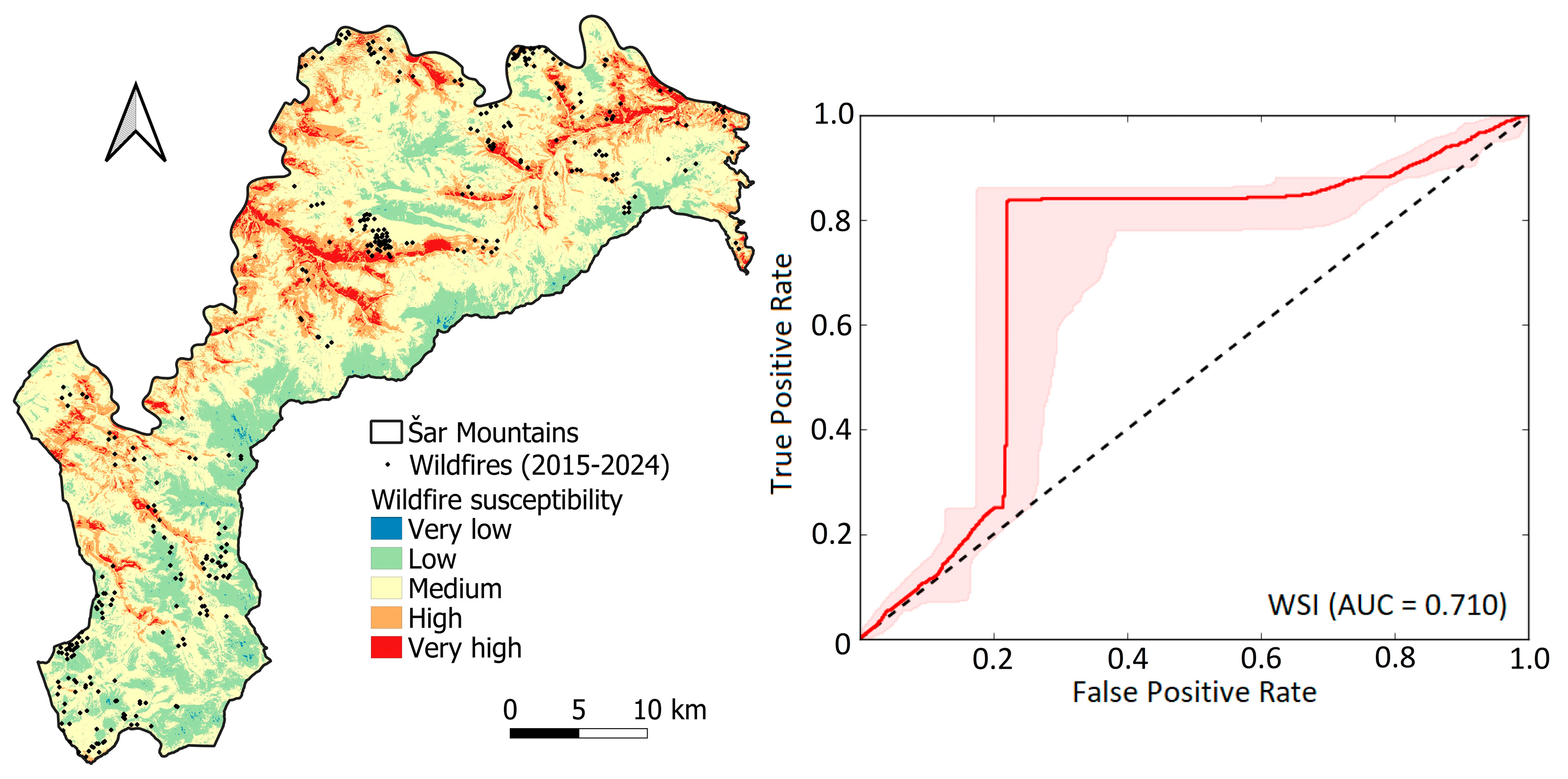
| Erosion Intensity | Area (km2) | Share of Total Area (%) | Wildfire Susceptibility | Area (km2) | Share of Total Area (%) |
|---|---|---|---|---|---|
| Very weak | 374.57 | 38.49 | Very low | 1.82 | 0.19 |
| Weak | 346.93 | 35.65 | Low | 204.89 | 21.06 |
| Medium | 149.81 | 15.40 | Medium | 558.65 | 57.41 |
| Intensive | 80.61 | 8.28 | High | 165.17 | 16.97 |
| Excessive | 21.16 | 2.17 | Very high | 42.53 | 4.37 |
Disclaimer/Publisher’s Note: The statements, opinions and data contained in all publications are solely those of the individual author(s) and contributor(s) and not of MDPI and/or the editor(s). MDPI and/or the editor(s) disclaim responsibility for any injury to people or property resulting from any ideas, methods, instructions or products referred to in the content. |
© 2025 by the authors. Licensee MDPI, Basel, Switzerland. This article is an open access article distributed under the terms and conditions of the Creative Commons Attribution (CC BY) license (https://creativecommons.org/licenses/by/4.0/).
Share and Cite
Durlević, U.; Srejić, T.; Valjarević, A.; Aleksova, B.; Deđanski, V.; Vujović, F.; Lukić, T. GIS-Based Spatial Modeling of Soil Erosion and Wildfire Susceptibility Using VIIRS and Sentinel-2 Data: A Case Study of Šar Mountains National Park, Serbia. Forests 2025, 16, 484. https://doi.org/10.3390/f16030484
Durlević U, Srejić T, Valjarević A, Aleksova B, Deđanski V, Vujović F, Lukić T. GIS-Based Spatial Modeling of Soil Erosion and Wildfire Susceptibility Using VIIRS and Sentinel-2 Data: A Case Study of Šar Mountains National Park, Serbia. Forests. 2025; 16(3):484. https://doi.org/10.3390/f16030484
Chicago/Turabian StyleDurlević, Uroš, Tanja Srejić, Aleksandar Valjarević, Bojana Aleksova, Vojislav Deđanski, Filip Vujović, and Tin Lukić. 2025. "GIS-Based Spatial Modeling of Soil Erosion and Wildfire Susceptibility Using VIIRS and Sentinel-2 Data: A Case Study of Šar Mountains National Park, Serbia" Forests 16, no. 3: 484. https://doi.org/10.3390/f16030484
APA StyleDurlević, U., Srejić, T., Valjarević, A., Aleksova, B., Deđanski, V., Vujović, F., & Lukić, T. (2025). GIS-Based Spatial Modeling of Soil Erosion and Wildfire Susceptibility Using VIIRS and Sentinel-2 Data: A Case Study of Šar Mountains National Park, Serbia. Forests, 16(3), 484. https://doi.org/10.3390/f16030484