Combining Remote Sensing and a Geographic Information System to Map and Assess the Accessibility of Invasive Alien Species Forest Stands: Case of Acacia mearnsii on Reunion Island


Abstract
:1. Introduction
2. Materials and Methods
2.1. Study Area
2.2. Data
2.2.1. Remote Sensing Data
2.2.2. Land Cover Reference Dataset
2.2.3. GIS Dataset
2.3. Mapping Forest Land Cover
2.3.1. Image Pre-Processing
2.3.2. Image Segmentation
2.3.3. Feature Selection and Classification
2.3.4. Accuracy Assessment
2.3.5. Post-Classification
2.4. Assessment of Accessible Forest Stands
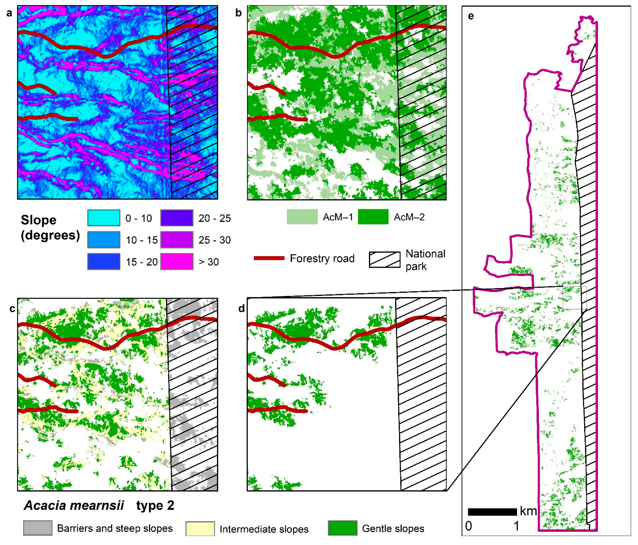
2.4.1. Barriers and Slope Characterization
- Impassable areas correspond to areas with the highest slope values (s ≥ s1), where no felling is possible, protected areas, or natural barriers;
- “Gentle slope” areas are defined as the areas with the lowest slope values (s ≤ s2), where mechanized felling and skidding are possible;
- “Intermediate slope” areas are defined as areas with intermediate slope values (s2 < s < s1); in these areas, only non-mechanizable felling techniques can be considered.
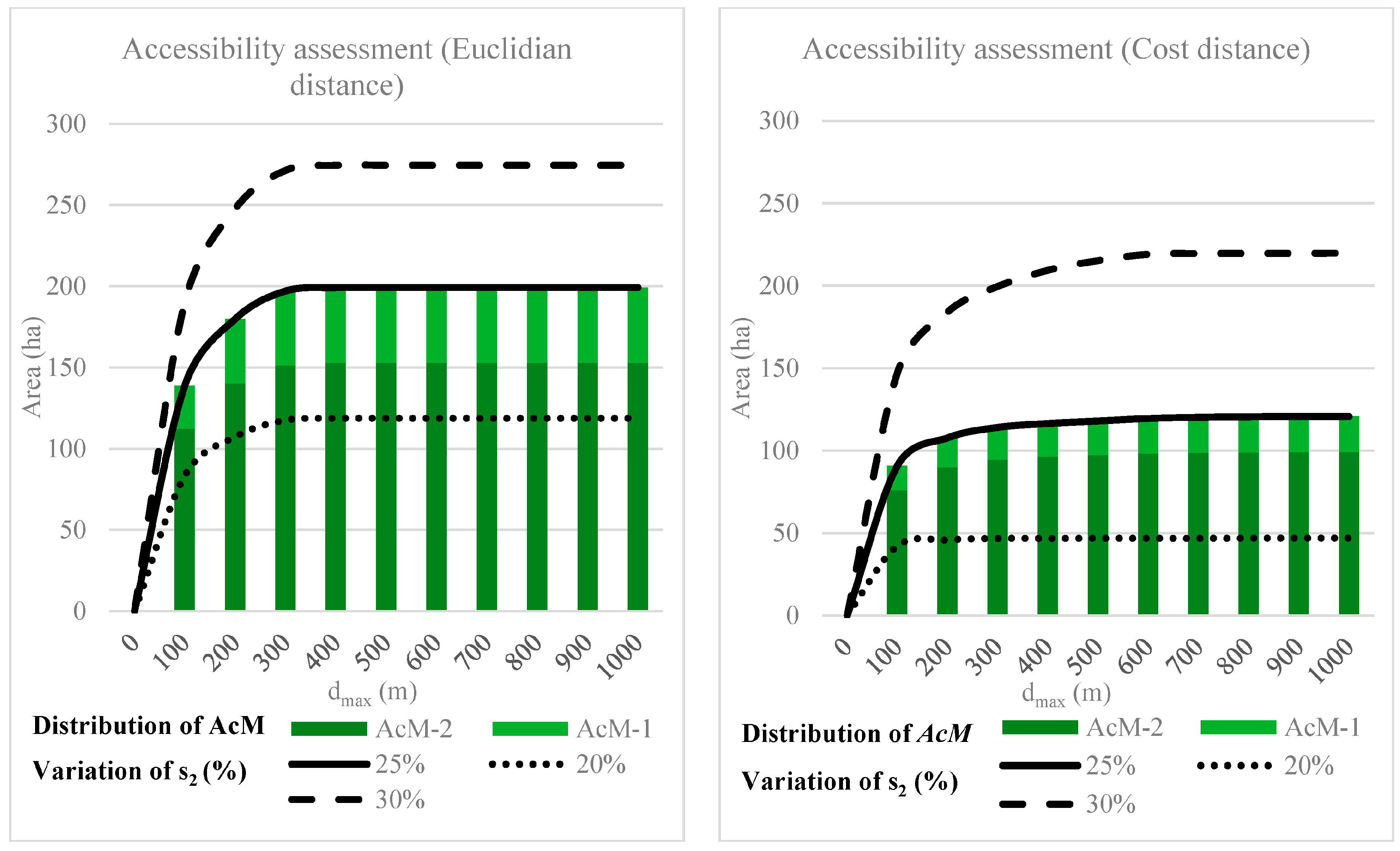
2.4.2. Accessibility Assessment
2.4.3. Application to Acacia mearnsii Forest Stands
3. Results
3.1. Map of Forest Land Cover
3.1.1. Importance of Spectral and Textural Information to Map Forest Stands
3.1.2. Accuracy Assessment
3.1.3. Spatial Distribution of Forest Stands
3.1.4. Uncertainty Map and Post Classification
3.2. Accessibility of Acacia mearnsii Forest Stands
3.2.1. Acacia mearnsii Accessible Areas According to a Standard Scenario
3.2.2. Assessment of Mechanizable Areas: Distance to Existing Roads and Sensitivity to Slope Threshold
4. Discussion
4.1. Detection of Acacia mearnsii Using Remote Sensing
4.2. Assessing the Accessibility of an Invasive Alien Species to Be Exploited in a Wood Energy Chain
5. Conclusions
Supplementary Materials
Author Contributions
Funding
Data Availability Statement
Acknowledgments
Conflicts of Interest
References
- Zambelli, P.; Lora, C.; Spinelli, R.; Tattoni, C.; Vitti, A.; Zatelli, P.; Ciolli, M. A GIS decision support system for regional forest management to assess biomass availability for renewable energy production. Environ. Model. Softw. 2012, 38, 203–213. [Google Scholar] [CrossRef]
- UICN. La Valorisation Socio-Économique Des Espèces Exotiques Envahissantes Établies en Milieux Naturels: Un Moyen de Régulation Adapté? Première Analyse et Identification de Points de Vigilance; UICN: Fontainebleau, France, 2018; p. 84. [Google Scholar]
- FAO. Le Bois-Énergie Dans la Région de la CEE: Données, Tendances et Perspectives en Europe, Dans la Communauté d’États Indépendants et en Amérique du Nord; Etudes de Genève sur le Bois et la Forêt de la CEE/FAO; Nations Unies: Genève, Switzerland, 2019. [Google Scholar]
- Tassin, J. Dynamique et Conséquences de l’Invasion des Paysages Agricoles des Hauts de la Réunion par Acacia mearnsii de Wild; Université Toulouse III—Paul Sabatier: Toulouse, France, 2002. [Google Scholar]
- Cadet, T.; Quézel, P. La Végétation de l’île de la Réunion: Étude Phytoécologique et Phytosociologique; University of Aix-Marseille: Marseille, France, 1977; 147p. [Google Scholar]
- Souza-Alonso, P.; Rodríguez, J.; González, L.; Lorenzo, P. Here to stay. Recent advances and perspectives about Acacia invasion in Mediterranean areas. Ann. For. Sci. 2017, 74, 55. [Google Scholar] [CrossRef]
- Searle, S.D. Acacia mearnsii de Wild (Black Wattle) in Australia. In Black Wattle and Its Utilisation; Rural Industries Research and Development Corporation: Canberra, Australia, 1997. [Google Scholar]
- Benoist, A.; van de Steene, L.; Broust, F.; Helias, A. Enjeux environnementaux du développement des biocarburants liquides pour le transport. Sci. Eaux Territ. 2012, 7, 66–73. [Google Scholar] [CrossRef]
- Tassin, J.; Balent, G. Le Diagnostic d’invasion d’une essence forestière en milieu rural: Acacia mearnsii à la Réunion. Rev. For. Française 2004, 56, 132–142. [Google Scholar] [CrossRef]
- ONF. Evaluation de la ressource mobilisable en bois energie. In Le Bois Energie sur l’île de la Réunion; Albioma, Office Nationale des Forets: Saint-Denis, Reunion, France, 2018. [Google Scholar]
- PPE. Programmation Pluriannuelle de l’Energie Pour la Réunion; Region Reunion, Prefecture de la Réunion: Saint-Denis, Reunion, France, 2016. [Google Scholar]
- Frombo, F.; Robba, M.; Rosso, F.; Sacile, R. Planning woody biomass logistics for energy production: A strategic decision model. Biomass Bioenergy 2009, 33, 372–383. [Google Scholar] [CrossRef]
- Vis, M.; Berg, D. Harmonization of Biomass Resource Assessments, Volume I, Best Practices and Methods Handbook; Biomass Energy Europe: Friburg, Germany, 2010. [Google Scholar]
- Woo, H.; Acuna, M.; Cho, S.J.; Park, J. Assessment Techniques in Forest Biomass along the Timber Supply Chain. Forests 2019, 10, 1018. [Google Scholar] [CrossRef]
- White, J.C.; Coops, N.C.; Wulder, M.A.; Vastaranta, M.; Hilker, T.; Tompalski, P. Remote Sensing Technologies for Enhancing Forest Inventories: A Review. Can. J. Remote Sens. 2016, 42, 619–641. [Google Scholar] [CrossRef]
- Kumar, L.; Sinha, P.; Taylor, S.; Alqurashi, A. Review of the use of remote sensing for biomass estimation to support renewable energy generation. J. Appl. Remote Sens. 2015, 9, 097696. [Google Scholar] [CrossRef]
- Piiroinen, R.; Heiskanen, J.; Maeda, E.; Viinikka, A.; Pellikka, P. Classification of Tree Species in a Diverse African Agroforestry Landscape Using Imaging Spectroscopy and Laser Scanning. Remote Sens. 2017, 9, 875. [Google Scholar] [CrossRef]
- Paz-Kagan, T.; Silver, M.; Panov, N.; Karnieli, A. Multispectral Approach for Identifying Invasive Plant Species Based on Flowering Phenology Characteristics. Remote Sens. 2019, 11, 953. [Google Scholar] [CrossRef]
- Joshi, C.; De Leeuw, J.; Van Duren, I. Remote sensing and GIS applications for mapping and spatial modeling of invasive species. Proc. ISPRS 2004, 35, B7. [Google Scholar]
- Masemola, C.; Cho, M.A.; Ramoelo, A. Sentinel-2 time series based optimal features and time window for mapping invasive Australian native Acacia species in KwaZulu Natal, South Africa. Int. J. Appl. Earth Obs. Geoinf. 2020, 93, 102207. [Google Scholar] [CrossRef]
- Anaya, J.A.; Chuvieco, E.; Palacios-Orueta, A. Aboveground biomass assessment in Colombia: A remote sensing approach. For. Ecol. Manag. 2009, 257, 1237–1246. [Google Scholar] [CrossRef]
- Helmer, E.H.; Ruzycki, T.S.; Benner, J.; Voggesser, S.M.; Scobie, B.P.; Park, C.; Fanning, D.W.; Ramnarine, S. Detailed maps of tropical forest types are within reach: Forest tree communities for Trinidad and Tobago mapped with multiseason Landsat and multiseason fine-resolution imagery. For. Ecol. Manag. 2012, 279, 147–166. [Google Scholar] [CrossRef]
- Oumar, M.S.; Peerbhay, K.Y.; Germishuizen, I.; Mutanga, O.; Oumar, Z. Detecting canopy damage caused by Uromycladium acaciae on South African Black Wattle forest compartments using moderate resolution satellite imagery. S. Afr. J. Geomat. 2019, 8, 69–83. [Google Scholar] [CrossRef]
- Chekchaki, S.; Beddiar, A.; Djalil Zaafour, M. Cartographie par télédétection des milieux envahis par Acacia mearnsii de Wild. dans l’extrême Nord-Est algérien. Bois For. Trop. 2020, 343, 5–16. [Google Scholar] [CrossRef]
- Masemola, C.; Cho, M.A.; Ramoelo, A. Assessing the Effect of Seasonality on Leaf and Canopy Spectra for the Discrimination of an Alien Tree Species, Acacia mearnsii, From Co-Occurring Native Species Using Parametric and Nonparametric Classifiers. IEEE Trans. Geosci. Remote Sens. 2019, 57, 5853–5867. [Google Scholar] [CrossRef]
- Arasumani, M.; Singh, A.; Bunyan, M.; Robin, V.V. Testing the efficacy of hyperspectral (AVIRIS-NG), multispectral (Sentinel-2) and radar (Sentinel-1) remote sensing images to detect native and invasive non-native trees. Biol. Invasions 2021, 23, 2863–2879. [Google Scholar] [CrossRef]
- Peerbhay, K.Y.; Mutanga, O.; Ismail, R. Investigating the Capability of Few Strategically Placed Worldview-2 Multispectral Bands to Discriminate Forest Species in KwaZulu-Natal, South Africa. IEEE J. Sel. Top. Appl. Earth Obs. Remote Sens. 2014, 7, 307–316. [Google Scholar] [CrossRef]
- Bley-Dalouman, H.; Broust, F.; Prevost, J.; Tran, A. Use of very high spatial resolution imagery for mapping wood energy potential from tropical managed forest stands, Reunion Island. Int. Arch. Photogramm. Remote Sens. Spat. Inf. Sci. 2021, XLIII-B3-2021, 189–194. [Google Scholar] [CrossRef]
- Wang, D.; Wan, B.; Qiu, P.; Su, Y.; Guo, Q.; Wu, X. Artificial Mangrove Species Mapping Using Pléiades-1: An Evaluation of Pixel-Based and Object-Based Classifications with Selected Machine Learning Algorithms. Remote Sens. 2018, 10, 294. [Google Scholar] [CrossRef]
- Blaschke, T. Object based image analysis for remote sensing. ISPRS J. Photogramm. Remote Sens. 2010, 65, 2–16. [Google Scholar] [CrossRef]
- Massetti, A.; Sequeira, M.M.; Pupo, A.; Figueiredo, A.; Guiomar, N.; Gil, A. Assessing the effectiveness of RapidEye multispectral imagery for vegetation mapping in Madeira Island (Portugal). Eur. J. Remote Sens. 2017, 49, 643–672. [Google Scholar] [CrossRef]
- Vainio, P.; Tokola, T.; Palander, T.; Kangas, A. A GIS-based stand management system for estimating local energy wood supplies. Biomass Bioenergy 2009, 33, 1278–1288. [Google Scholar] [CrossRef]
- Dupire, S.; Bourrier, F.; Monnet, J.-M.; Berger, F. Sylvaccess : Un modèle pour cartographier automatiquement l’accessibilité des forêts. Rev. For. Française 2015, 70, 111–126. [Google Scholar] [CrossRef]
- Tucker, C.J. Red and photographic infrared linear combinations for monitoring vegetation. Remote Sens. Environ. 1979, 8, 127–150. [Google Scholar] [CrossRef]
- Kriegler, F.J.; Malila, W.A.; Nalepka, R.F.; Richardson, W. Preprocessing Transformations and Their Effects on Multispectral Recognition. Proc. VI Int. Symp. Remote Sens. Environ. 1969, 2, 97. [Google Scholar]
- McFeeters, S.K. The use of the Normalized Difference Water Index (NDWI) in the delineation of open water features. Int. J. Remote Sens. 1996, 17, 1425–1432. [Google Scholar] [CrossRef]
- Gamon, J.A.; Surfus, J.S. Assessing leaf pigment content and activity with a reflectometer. New Phytol. 1999, 143, 105–117. [Google Scholar] [CrossRef]
- Huete, A.R. A soil-adjusted vegetation index (SAVI). Remote Sens. Environ. 1988, 25, 295–309. [Google Scholar] [CrossRef]
- Haralick, R.M.; Shanmugam, K.; Dinstein, I. Textural Features for Image Classification. IEEE Trans. Syst. Man Cybern. 1973, SMC-3, 610–621. [Google Scholar] [CrossRef]
- Crespin-Boucaud, A.L.V.; Lo Seen, D.; Castets, M.; Bégué, A. Agriculturally consistent mapping of smallholder farming systems using remote sensing and spatial modelling. Int. Arch. Photogramm. Remote Sens. Spat. Inf. Sci. 2020, XLII-3/W11, 35–42. [Google Scholar] [CrossRef]
- Dupuy, S.; Gaetano, R.; Le Mezo, L. Mapping land cover on Reunion Island in 2017 using satellite imagery and geospatial ground data. Data Brief 2020, 28, 104934. [Google Scholar] [CrossRef]
- Breiman, L. Random Forests. Mach. Learn. 2001, 45, 5–32. [Google Scholar] [CrossRef]
- Cutler, A.; Cutler, D.; Stevens, J.R. Random forests. Mach. Learn 2011, 45, 157–176. [Google Scholar]
- Congalton, R.G. A review of assessing the accuracy of classifications of remotely sensed data. Remote Sens. Environ. 1991, 37, 35–46. [Google Scholar] [CrossRef]
- Prasad, M.S.G.; Arora, M.K. Representing Uncertainty in Fuzzy Land Cover Classification: A Comparative Assessment. J. Remote Sens. Technol. 2015, 3, 34–45. [Google Scholar] [CrossRef]
- Ienco, D.; Gaetano, R.; Dupaquier, C.; Maurel, P. Land cover classification via multitemporal spatial data by deep recurrent neural networks. IEEE Geosci. Remote Sens. Lett. 2017, 14, 1685–1689. [Google Scholar] [CrossRef]
- Enache, A.; Kühmaier, M.; Visser, R.; Stampfer, K. Forestry operations in the European mountains: A study of current practices and efficiency gaps. Scand. J. For. Res. 2016, 31, 412–427. [Google Scholar] [CrossRef]


| Land Cover Type | Main Characteristics | Denomination |
|---|---|---|
| Herbaceous | Mixed species, dense shrubs | Herb |
| Bare soil | Grassland, low vegetation cover | Soil |
| Road | Impervious area | Road |
| Shade | Sha | |
| Cryptomeria japonica | Plantations homogenous | CrJ |
| Acacia heterophylla—Type 1 | High stand density, natural or managed forest | AcH-1 |
| Acacia heterophylla—Type 2 | Low stand density, replantation | AcH-2 |
| Acacia mearnsii—Type 1 | Entangled trunks, difficult to penetrate | AcM-1 |
| Acacia mearnsii—Type 2 | Straight trunks, easily penetrable forest | AcM-2 |
| Radiometric Indices | Notation | Equation | References |
|---|---|---|---|
| Normalized Difference Vegetation Index | NDVI | [34] | |
| Ratio Vegetation Index | RVI | [35] | |
| Normalized Difference Vegetation Index 2 | NDWI2 | [36] | |
| Red/Green Ratio | RGR | [37] | |
| Soil-Adjusted Vegetation Index | SAVI | [38] |
| Reference | |||||||||||
|---|---|---|---|---|---|---|---|---|---|---|---|
| Shade | Road + Bare Soil | Herb | CrJ | AcH-1 | AcH-2 | AcM-1 | AcM-2 | Total | UA | ||
| CLASS | Shade | 853 | 0 | 0 | 0 | 0 | 0 | 0 | 0 | 853 | 1 |
| Road + Bare soil | 0 | 24,991 | 59 | 0 | 0 | 0 | 0 | 33 | 25,083 | 1.00 | |
| Herb | 0 | 522 | 19,415 | 1 | 2 | 8 | 135 | 42 | 20,125 | 0.96 | |
| CrJ | 0 | 1 | 39 | 21,816 | 38 | 34 | 121 | 1385 | 23,434 | 0.93 | |
| AcH-1 | 0 | 1 | 164 | 111 | 17,343 | 4 | 351 | 518 | 18,492 | 0.94 | |
| AcH-2 | 0 | 0 | 595 | 149 | 24 | 3736 | 0 | 618 | 5122 | 0.73 | |
| AcM-1 | 0 | 2 | 10 | 700 | 1364 | 0 | 3519 | 3120 | 8715 | 0.40 | |
| AcM-2 | 0 | 1 | 52 | 1566 | 723 | 506 | 498 | 13,856 | 17,202 | 0.81 | |
| TOTAL | 853 | 25,518 | 20,334 | 24,343 | 19,494 | 4288 | 4624 | 19,572 | 119,026 | ||
| PA | 1.00 | 0.98 | 0.95 | 0.90 | 0.89 | 0.87 | 0.76 | 0.71 | |||
| Barriers and Slope Characterization s1 = 50%; s2 = 25% | Accessibility Assessment dmax = 1000 m | |||||
|---|---|---|---|---|---|---|
| Acacia mearnsii (AcM) | Burned Area (ha) | Barrier and Steep Slope (ha) | Intermediate Slope (ha) | Gentle Slope (ha) | Euclidean Distance (ha) | Cost Distance (ha) |
| AcM-1 | 221 | 112 | 60 | 49 | 49 | 22 |
| AcM-2 | 416 | 102 | 159 | 155 | 155 | 99 |
| Total | 637 | 214 (34%) | 219 (34%) | 204 (32%) | 204 (32%) | 121 (19%) |
Disclaimer/Publisher’s Note: The statements, opinions and data contained in all publications are solely those of the individual author(s) and contributor(s) and not of MDPI and/or the editor(s). MDPI and/or the editor(s) disclaim responsibility for any injury to people or property resulting from any ideas, methods, instructions or products referred to in the content. |
© 2023 by the authors. Licensee MDPI, Basel, Switzerland. This article is an open access article distributed under the terms and conditions of the Creative Commons Attribution (CC BY) license (https://creativecommons.org/licenses/by/4.0/).
Share and Cite
Bley Dalouman, H.; Broust, F.; Tran, A. Combining Remote Sensing and a Geographic Information System to Map and Assess the Accessibility of Invasive Alien Species Forest Stands: Case of Acacia mearnsii on Reunion Island. Forests 2023, 14, 2030. https://doi.org/10.3390/f14102030
Bley Dalouman H, Broust F, Tran A. Combining Remote Sensing and a Geographic Information System to Map and Assess the Accessibility of Invasive Alien Species Forest Stands: Case of Acacia mearnsii on Reunion Island. Forests. 2023; 14(10):2030. https://doi.org/10.3390/f14102030
Chicago/Turabian StyleBley Dalouman, Hélène, François Broust, and Annelise Tran. 2023. "Combining Remote Sensing and a Geographic Information System to Map and Assess the Accessibility of Invasive Alien Species Forest Stands: Case of Acacia mearnsii on Reunion Island" Forests 14, no. 10: 2030. https://doi.org/10.3390/f14102030
APA StyleBley Dalouman, H., Broust, F., & Tran, A. (2023). Combining Remote Sensing and a Geographic Information System to Map and Assess the Accessibility of Invasive Alien Species Forest Stands: Case of Acacia mearnsii on Reunion Island. Forests, 14(10), 2030. https://doi.org/10.3390/f14102030