Article

Analysis of Factors Related to Forest Fires in Different Forest Ecosystems in China

Key Laboratory of Sustainable Forest Ecosystem Management-Ministry of Education, School of Forestry, Northeast Forestry University, Harbin 150040, China
*
Authors to whom correspondence should be addressed.
Forests 2022, 13(7), 1021; https://doi.org/10.3390/f13071021
Submission received: 19 May 2022 / Revised: 25 June 2022 / Accepted: 26 June 2022 / Published: 29 June 2022
(This article belongs to the Special Issue Fire Ecology and Management in Forest)

Abstract

:
Forests are the largest terrestrial ecosystem with major benefits in three areas: economy, ecology, and society. However, the frequent occurrence of forest fires has seriously affected the structure and function of forests. To provide a strong scientific basis for forest fire prevention and control, Ripley’s K(d) function and the LightGBM algorithm were used to determine the spatial pattern of forest fires in four different provinces (Heilongjiang, Jilin, Liaoning, Hebei) in China from 2019 to 2021 and the impact of driving factors on different ecosystems. In addition, this study also identified fire hotspots in the four provinces based on kernel density estimation (KDE). An artificial neural network model (ANN) was created to predict the probability of occurrence of forest fires in the study area. The results showed that the forest fires were spatially clustered, but the variable importance of different factors varied widely among the different forest ecosystems. Forest fires in Heilongjiang and Liaoning Provinces were mainly caused by human-driven factors. For Jilin, meteorological factors were important in the occurrence of fires. Topographic and vegetation factors exhibited the greatest importance in Hebei Province. The selected driving factors were input to the ANN model to predict the probability of fire occurrence in the four provinces. The ANN model accurately captured 93.17%, 90.28%, 83.16%, and 89.18% of the historical forest fires in Heilongjiang, Jilin, Liaoning, and Hebei Provinces; Precision, Recall, and F-measure based on the full dataset are 0.87, 0.88, and 0.87, respectively. The results of this study indicated that there were differences in the driving factors of fire in different forest ecosystems. Different fire management policies must be formulated in response to this spatial heterogeneity.

1. Introduction

Although small-scale forest fires can play a role in promoting forest ecosystems and species evolution, large-scale forest fires are a key driver of natural landscape and ecosystem damage [1,2]. Studies have shown that forest fires not only cause damage to natural resources and ecosystems but also have harmful effects on human life [3,4,5]. Statistics show that more than 200,000 forest fires occur around the world every year [6]. The China Forestry Administration also reported that in the past ten years, the total number of forest fires in China has exceeded 10,000 each year. General fires (with less than 1 hectare of affected forest area) and larger fires (affected forest area greater than 1 hectare but less than 100 hectares) are the main types and they have had substantial social and ecological impacts [7]. Since the “Forest Law of the People’s Republic of China” was proposed by the State Council of China in 2008, national and regional governments have continuously improved fire management policies based on different local forest fire prevention conditions and characteristics, but forest fires still occur frequently. These fire events highlight the need to deepen our understanding of the spatial distribution and drivers of forest fires and the importance of combining forest fire management with preventive management [8,9,10].
A series of studies on the driving factors and spatial distribution of forest fires have been carried out by researchers [11,12,13]. We now have a better understanding of the factors that affect forest fires. Studies have shown that forest fires are the result of the interaction of multiple factors, and the importance of fire factors varies in different ecosystems [14]. These factors are mainly divided into four categories: climatic factors, topographic factors, vegetation factors, and human drivers [15,16]. The likelihood of forest fires is closely related to these factors, and they even affect the characteristics of fire frequency, intensity, timing, etc. [17]. Fires also have an impact on these factors; for example, studies have shown that the occurrence of forest fires changes the distribution of vegetation [18].
Climatic factors affect the wind and water balance and fire heat transfer of forest combustibles [19,20]. They also affect the moisture content of forest fire combustibles [21]. The occurrence of extreme forest fires is also closely related to climatic factors [22]. With the continuous development of the social economy and modern transportation, human factors have become key drivers of new forest fires [23,24,25,26,27,28]. Human factors affect not only the occurrence of forest fires but also the intensity, frequency, and distribution of forest fires. In addition to the above factors, some studies have shown that topographic factors also have an impact on forest fire, and the aspect and slope can affect the moisture content of forest fuels and the convective heat and radiation intensity received [27,29]. The higher the altitude is, the lower the humidity, making the area less prone to forest fires. The complexity and multiplicity of forest fire systems is due to the combined influence of various factors in different ecosystems [30,31,32]. Because of this, forest management and forest fire resource allocation in different regions are inconsistent.
The forest coverage rate in China has reached 23.04%, and the forest area is 220 million hectares. The vegetation types in different regions are significantly different. Studies have shown that different combustible species in evergreen coniferous forests, deciduous coniferous forests, and temperate deciduous broad-leaved forests can interfere with forest fires [27,33]. Therefore, in this study, we selected Heilongjiang, Jilin, Liaoning, and Hebei as the research areas for the analysis of the drivers of forest fires and the occurrence of fires. According to the forest resources inventory data released by the China Forestry Administration, the proportion of evergreen coniferous forests in Hebei, Liaoning, Jilin, and Heilongjiang provinces is 20.05%, 13.75%, 4.50%, and 35.50%, respectively. The proportion of deciduous coniferous forests in the four provinces was 7.39%, 10.47%, 8.22%, and 16.50%, respectively. The proportion of temperate broad-leaved forest in the four different provinces was 64.95%, 44.30%, 25.22%, and 35.50%, respectively. Most of the previous studies analyzed the fire drivers in a single province [27,34,35], and there have been few studies on the spatial pattern of forest fires. Analyzing the causes of forest fires in different provinces can improve the accuracy of forest management and forest fire prevention and fire suppression.
Considering the above factors, different types of combustibles were extracted from forest ecosystems in four northern provinces of China (Heilongjiang, Liaoning, Jilin, Hebei) for research. The main purposes of this study are (1) to analyze the spatial pattern of forest fires in different regions and to find hotspots of forest fires; (2) to compare differences in fire drivers in four different provinces in China and to identify important fires; and (3) to build an artificial neural network model to predict the occurrence of forest fires in different study areas. With the goal of improving fire management policies, this study aims to provide insights and guide fire management in different regions of China.

2. Materials and Methods
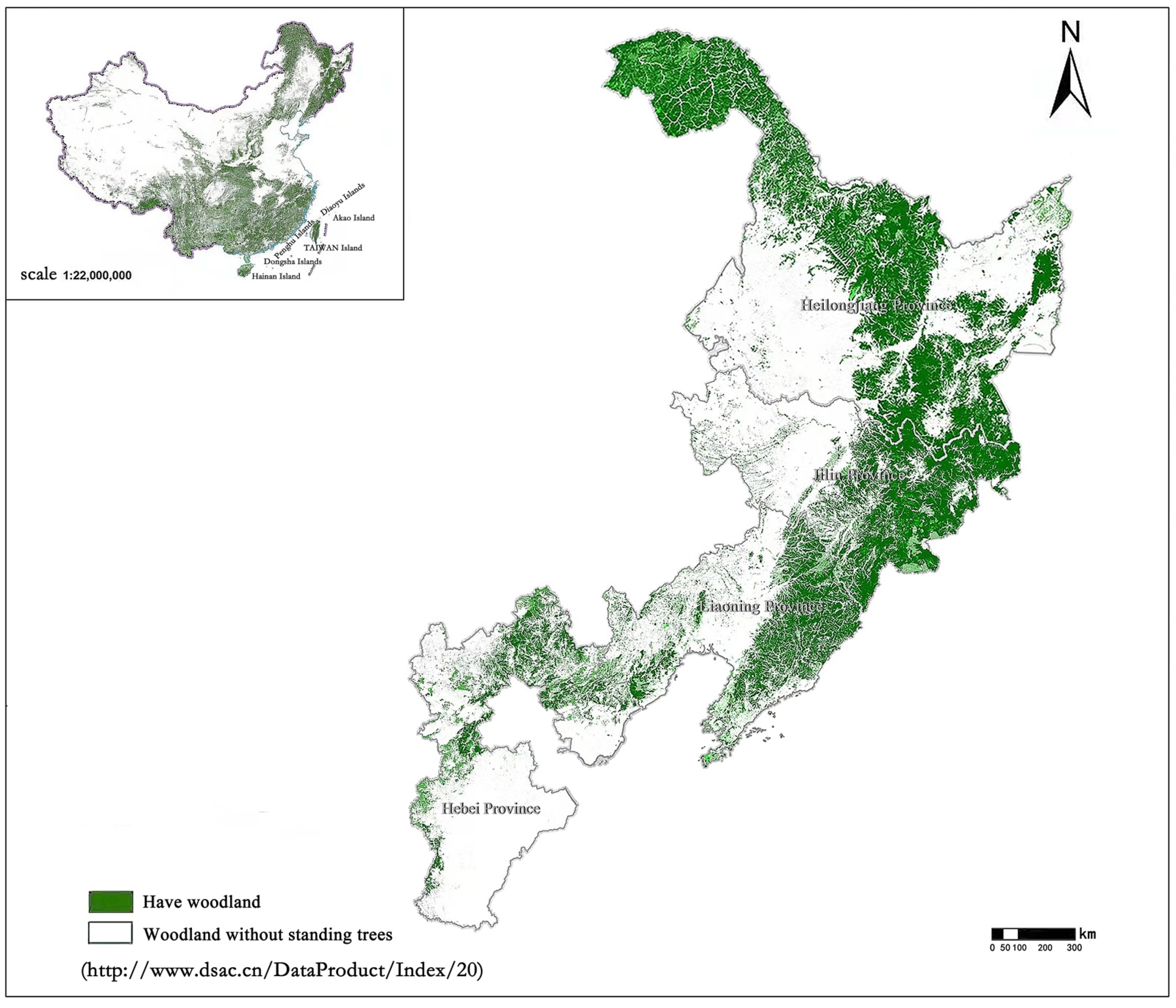
2.1. Study Area

We selected four different provinces in China for our study: Heilongjiang, Jilin, Liaoning, and Hebei (Figure 1). The four provinces differ in their geographical location, topography, and climate. The study areas are located in Northeast China and Northern China, between 113°27′–135°05′ east longitude and 36°05′–53°33′ north latitude. Heilongjiang is the easternmost and northernmost province of China and is the province with the easternmost longitude and the highest latitude. The forest coverage rate of the province is 43.78%, and the total forest area is 19.9046 million hectares. The climate of the province is cold temperate and temperate continental monsoon and the annual average temperature in the forest area is approximately 4 °C. According to the data collected from the China Meteorological Administration, the historical maximum temperature in Heilongjiang woodland is 41.6 °C, the historical minimum temperature is −52.3 °C, and the annual precipitation is approximately 600 mm. The main forests in Heilongjiang are cold temperate coniferous forest and temperate coniferous and broad-leaved mixed forest. Jilin is located in the middle of northeastern China, with a forest coverage rate of 41.49% and a total forest area of 7,848,700 hectares. Jilin has a temperate monsoon climate. The data show that its historical maximum temperature is 36.6 °C, and the extreme minimum temperature is −40.2 °C. The average annual precipitation is 400–500 mm. The forest areas in Jilin Province are mainly temperate coniferous and broad-leaved mixed forests. Liaoning is located in the southern part of Northeast China, with a forest coverage rate of 39.24% and a total area of 5.7183 million hectares. The annual average temperature in the forest area is approximately 9 °C and the province has a temperate monsoon climate. The historical extreme maximum and minimum temperatures were 36.9 °C and −20.1 °C, respectively. The average precipitation in forest areas in Liaoning Province is 450–500 mm. The main vegetation types are temperate coniferous and broad-leaved mixed forest and warm temperate deciduous broad-leaved forest. Hebei is located in North China, with a forest coverage rate of 26.78% and a total forest area of 5.0269 million hectares. It has a temperate continental monsoon climate. The historical extreme maximum and minimum temperatures are 41.8 °C and −34.7 °C, respectively, and the average precipitation is 300–400 mm. The deciduous broad-leaved forest is dominant. According to statistics, the frequency of forest fires in Heilongjiang is much higher than that in the other four provinces, and the frequency of forest fires in Liaoning is the lowest.

2.2. Data Preparation

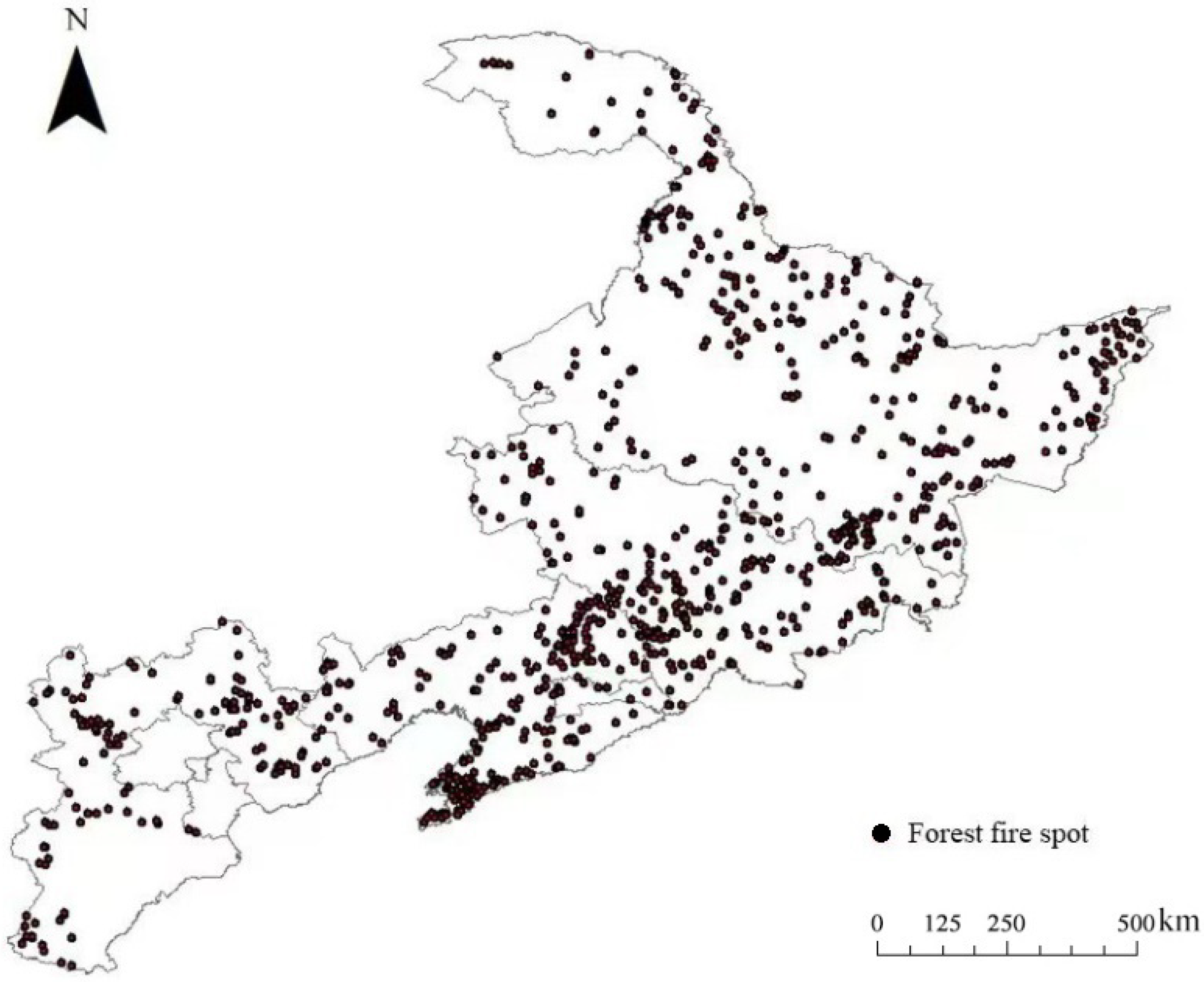
2.2.1. Fire Data Collection and Control Point Generation

To explore the distribution and driving factors of fire hotspots in the study area, we collected forest fire disturbance data from 2019 to 2021 from the State Forestry Administration. The collected dataset includes text information such as fire occurrence time, end time, latitude and longitude coordinates in four different provinces in China (Heilongjiang, Jilin, Liaoning, and Hebei) from 2019 to 2021. Since the forest fire data come from statistics collected by various levels of government, this mode of collection can lead to biases and errors in forest fire disturbance data, and text information requires actual image information for verification and calibration. Therefore, to prevent the problems caused by data errors, we chose to obtain National Polar Orbiting Partnership (NPP) and Landsat satellite imagery based on textual fire occurrence times and geographic coordinates. We calibrated the text information regarding the fire disturbance and supplemented the fire burning area on this basis. The resolution of the product is 30 × 30 m. Studies have shown that Landsat satellites and NPP are reliable tools for forest fire monitoring [36,37]. Although they have many advantages for monitoring of forest fires, there are still many interfering factors that can cause errors in fire identification (for example, waste incineration, straw incineration, and local high temperature). We used the normalized burning index (NBR) to discriminate forest fires in the study area from 2019 to 2021 and extract the fire contours. Some studies have shown that the index can effectively rule out the misidentification of non-forest fire areas caused by excessive temperature [38,39,40]. We labelled each extracted pixel unit as a fire point. The NBR index is highly sensitive to forest fires and is often used to extract forest fire boundaries and fire intensity, and it is calculated as the ratio between the near-infrared and mid-near-infrared bands [38]. The value of the NBR index ranges from −1 to 1, and the larger the index value is, the smaller the fire intensity.
NBR   = NIR     SWIR / NIR   +   SWIR
where NIR is the near-infrared band and SWIR is the mid-near-infrared band.
We used the NBR index to rigorously review forest fire sources to ensure and improve the accuracy of forest fire data. Figure 2 is an example showing the fire hotspots in Heilongjiang, Jilin, Liaoning, and Hebei provinces in China after screening in 2021. On this basis, we also randomly selected the same number of non-fire points as fire points to be the control points [41,42]. The selection of random control points satisfied the double randomness principle of randomness in space and time. To avoid selecting control points next to a fire point, we set a 1 km isolation belt around fire points and avoided selecting control points in the isolation belt.

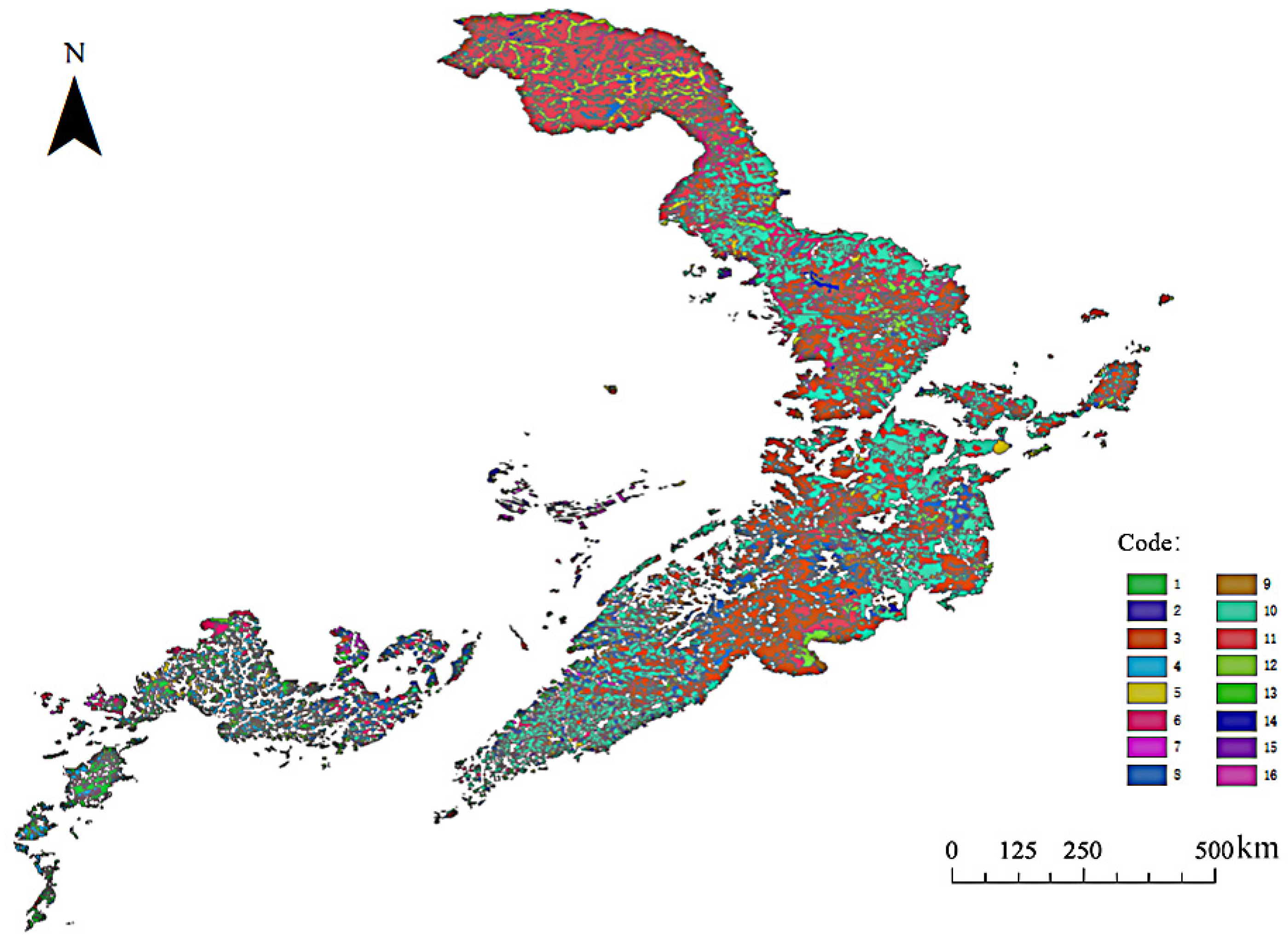
2.2.2. Driving Factors

In this study, the influencing factors of forest fire can be divided into four categories: climatic factors, topographic factors, vegetation factors, and human driving factors. These factors involve a total of 19 variables in four categories. For the four different provinces in this study, the analysis of the drivers of fire was first based on a single forest fire driving category and then based on a combination of multicategory forest fire factors. A detailed description of the 19 variables is presented in Table 1.
It is well known that climatic conditions can directly lead to changes in the state of forest combustible fuels, thereby affecting the occurrence of forest fires [13,43,44]. Studies have shown that the occurrence of forest fires is closely related to the average temperature, relative humidity, and precipitation of the environment [45]. If the monthly precipitation in an area exceeds 100 mm or more, the probability of forest fires in that area is extremely low. Temperature and humidity also affect the amount of heat that combustibles release during combustion. There are also studies showing that the climatic factors of the previous year’s fire season can significantly affect the occurrence of the following year’s fires [46]. Therefore, we collected the daily average temperature, relative humidity, and precipitation on the day of the fire, the average temperature, relative humidity, and precipitation in the fire season and the previous year’s fire season from the China Meteorological Data Center.
Studies have shown that the size of the slope will not only affect the water retention time of forest fuels but also have a great impact on heat transmission [47]. Different slope conditions will receive different levels of sunlight exposure, which will affect humidity and temperature. Compared with other aspects, the southern slope is more prone to forest fire, and the spread rate is faster [48]. The higher the altitude is, the higher the relative humidity, and the less prone to forest fires [27,28]. Therefore, we obtained a high-resolution (12.5 m) digital elevation model (DEM) of the terrain from the National Bureau of Surveying, Mapping and Geographical Information of China. Data regarding the slope, aspect, and elevation of the study area were extracted.
Based on previous research, we collected the distribution of vegetation types in four provinces from the Chinese Academy of Sciences, and divided the types of combustibles of three different ecological types in the four provinces [49]: seasonal fire-resistant forest combustibles (acacia forest, etc., flammable in seasons in which canopy fire cannot occur, code 1), seasonal flammable forest combustibles (elm sparse forest, etc., in seasons when crown fire cannot occur, code 2), medium combustible forest combustibles (linden, maple, etc., in seasons when crown fire cannot occur, code 3), seasonal fire-resistant bushes (lilac bushes, etc., code 4), seasonal and year-round fire-resistant herbaceous combustibles (reed meadow, etc., code 5), seasonal year-round moderately combustible herbaceous combustibles (white yew grass, etc., code 6), seasonal inflammable herbaceous combustibles (miscanthus grassland, etc., code 7), seasonal moderately combustible shrubs (Vitex, jujube bushes, etc., code 8), seasonal fire-resistant forest combustibles (Landwhite larch forest, etc., code 9), seasonal flammable forest combustibles (Mongolia oak forest, etc., code 10), canopy fire can occur in the presence of seasonal medium flammable forest combustibles (Xing’an larch forest, etc., code 11), year-round fire-resistant forest combustibles (fish scale spruce forest, etc., code 12) that can cause canopy fires, year-round flammable forest combustibles (oil pine forests, etc., code 13), year-round moderately flammable forest combustibles (Pinus sylvestris forests, etc., code 14), year-round noncombustible herbaceous combustibles (jellyfish snow lotus, sparse vegetation of wind chrysanthemum, etc., code 15), year-round flame-retardant herbaceous combustibles (code 16) (Figure 3) [50].
In order to facilitate the input of 16 types of combustibles into the constructed model, this study has selected to use numbers 1–16 to represent different types of combustibles in the fire area. Fractional vegetation cover (FVC) can be used to express the amount of fire fuel [51]. FVC is the percentage of vertical projection of the canopy to the ground in a unit area. This parameter can be calculated by using NDVI [52].
FVC   = NDVI NDVIsoil   / NDVIveg NDVIsoil
where NDVIveg and NDVIsoil are the NDVI of the vegetation canopy and bare soil in the forest, respectively. Therefore, we obtained the FVC from the NDVI data collected from the Computer Network Information Center of the Chinese Academy of Sciences.
Due to socioeconomic development in recent decades, population mobility has increased. Increased tourism and recreational activities within forests have led to increased access to forest ecosystems [53]. Smoking in the wild, burning ash and fertilizing and other behaviors can lead to the occurrence of forest fires under adverse weather factors. The human drivers involved in this study therefore include population density, GDP, and proximity of fires to railways, roads, and settlements. These factors not only reflect human accessibility to forest ecosystems but also people’s willingness to travel to forests at different population densities and at different GDPs [54]. Therefore, this study collected gridded population density and GDP data from Earth System Science and the National Statistical Yearbook with a resolution of 100 m. The shortest distances from points to roads, railways, and settlements were obtained and processed from the National Geographic Information Directory Service.

2.3. Statistical Analysis

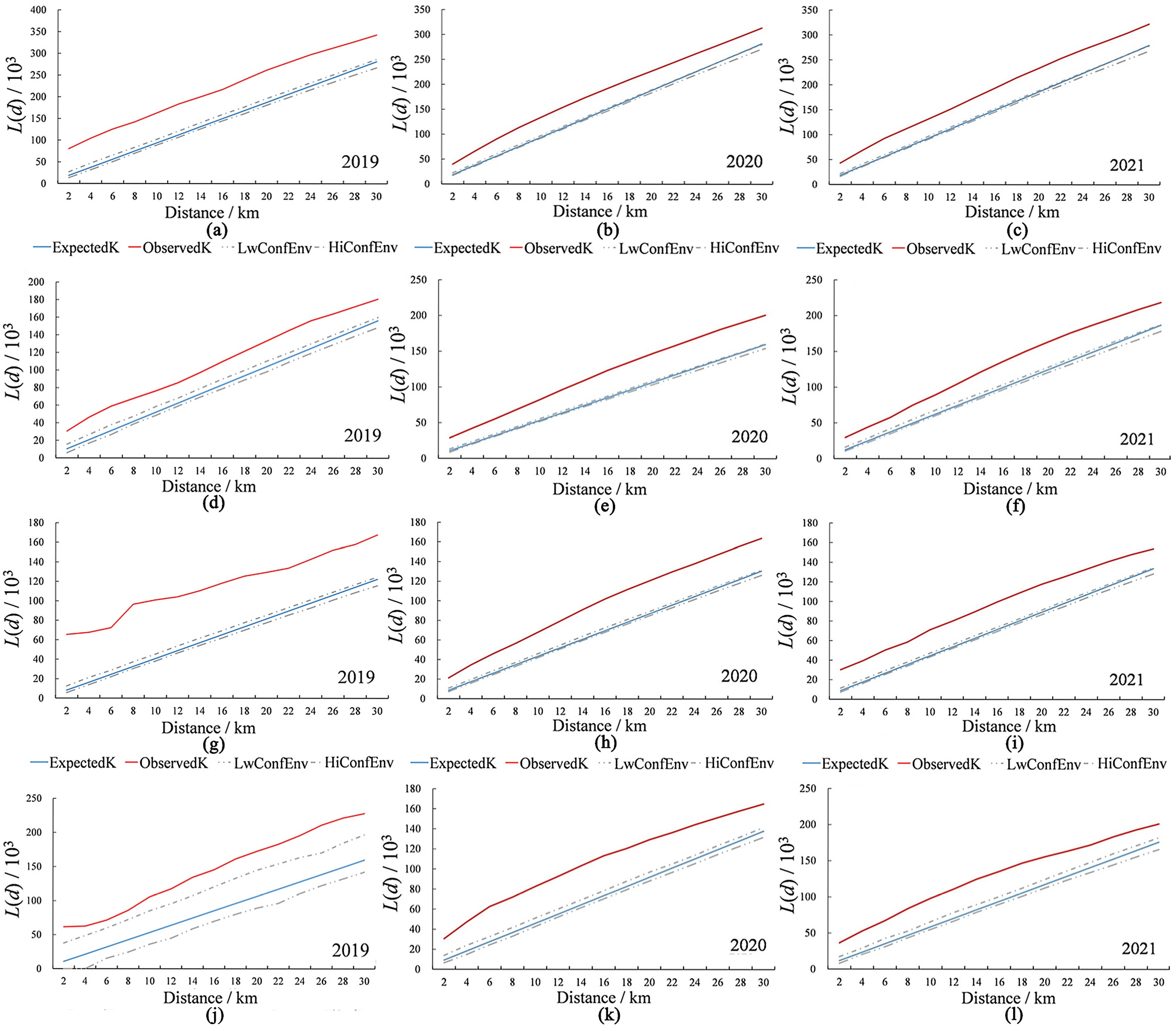
2.3.1. Spatial Cluster Analysis of Fire Density

In this study, we used a multidistance spatial cluster analysis method to explore the spatial distribution of fire densities of forest fires in the study area. The multidistribution spatial clustering distribution (Ripley’s K function) is widely used to describe the relationship between points and point patterns [11,55]. Ripley’s K method is an analysis method for point data patterns that can use Ripley’s K function to analyze the degree of clustering of point datasets at different distances. This function can indicate how the spatial aggregation or spatial diffusion of feature centroids changes when the neighborhood size changes [56]. Ripley’s K(d) function is defined as:
K d = A i = 1 n j = 1 n d i j d n 2 i , j = 1 , 2 , , n , i j , d i j d  
where n is the number of fire points, d is the distance scale, this represents the distance to any point. dij is the distance between fire points i and j, and A is the area of the study area. In these four study areas, we set the value of d to 10 km to ensure the operation of Ripley’s K(d) function. To make the results more reliable and stable, the square root of K(d)/π is introduced to correct the function, resulting in the L(d) function with the following equation.
L d = K d π d  
We compare the L(d) value with the expected value, the upper data packet trace and the lower data packet trace. If the value of L(d) is larger than expected, the fire spot will show an aggregated distribution. If the value of L(d) is smaller than expected, it means that the fire points show a discrete distribution. If the value of L(d) is larger than that of the upper data packet trace, the spatially clustered distribution of fire points is statistically significant. The spatially discrete distribution of fire points is statistically significant if the value of L(d) is smaller than that of the lower data packet trace.

2.3.2. Forest Fire Hotspot Analysis

To help forest managers and firefighters better plan firefighting, we used kernel density estimation (KDE) to explore fire hotspots in the study area. This method was first proposed by Rosenblatt and Emanuel Parzen [57]. It is a nonparametric method for testing that takes into account events that occur anywhere in space but with varying probability at different locations [58]. The KDE method can discover data distribution characteristics based on multidimensional space. Regions with dense points have a higher probability of events, while regions with sparse points have a lower probability of events. Therefore, the spatial density of events can be used to represent spatial point patterns. In this study, the kernel density analysis method was used to calculate the important aggregation area of forest fires in each province. The expression for the density f(x) at point x where the fire occurred is shown in Equation (5).
f x = 1 n h i = 1 n k x x i h  
where k is the kernel function; h is the bandwidth of the kernel function; x is the set of fire points (x1, x2, …, xn); and xxi is the distance from the estimated point to sample xi.

2.3.3. Importance Analysis of Forest Fire Factors

In research on the driving factors for fires and forest fire prediction, it is important to prioritize exploring the factors that affect the occurrence of forest fires. The goal is to assess the relative importance of the explanatory variables in the four provinces by ranking the forest fire factors in order of importance. However, due to the very complex nonlinear relationship between forest fire factors [15,59], the traditional logistic regression method cannot effectively explain the relationship of the variables. Therefore, in this study, the LightGBM algorithm was used to explore the importance of forest fire factors in different study areas. The LightGBM algorithm is based on the improvement of the basic derivation of the Gradient Boosted Decision Trees (GBDT) and XGBoost models. It is a fast and high-performance decision tree algorithm. This algorithm was first proposed in 2016 [60]. It can optimize the main parameters of the control tree model, has fast training speed, exhibits good accuracy, and can avoid overfitting. At the same time, this study uses a grid search method to specify model parameter values, which can obtain optimal values by optimizing the parameters of the estimated function through cross-validation, the hyperparameters used by the LightGBM algorithm are shown in Table 2.

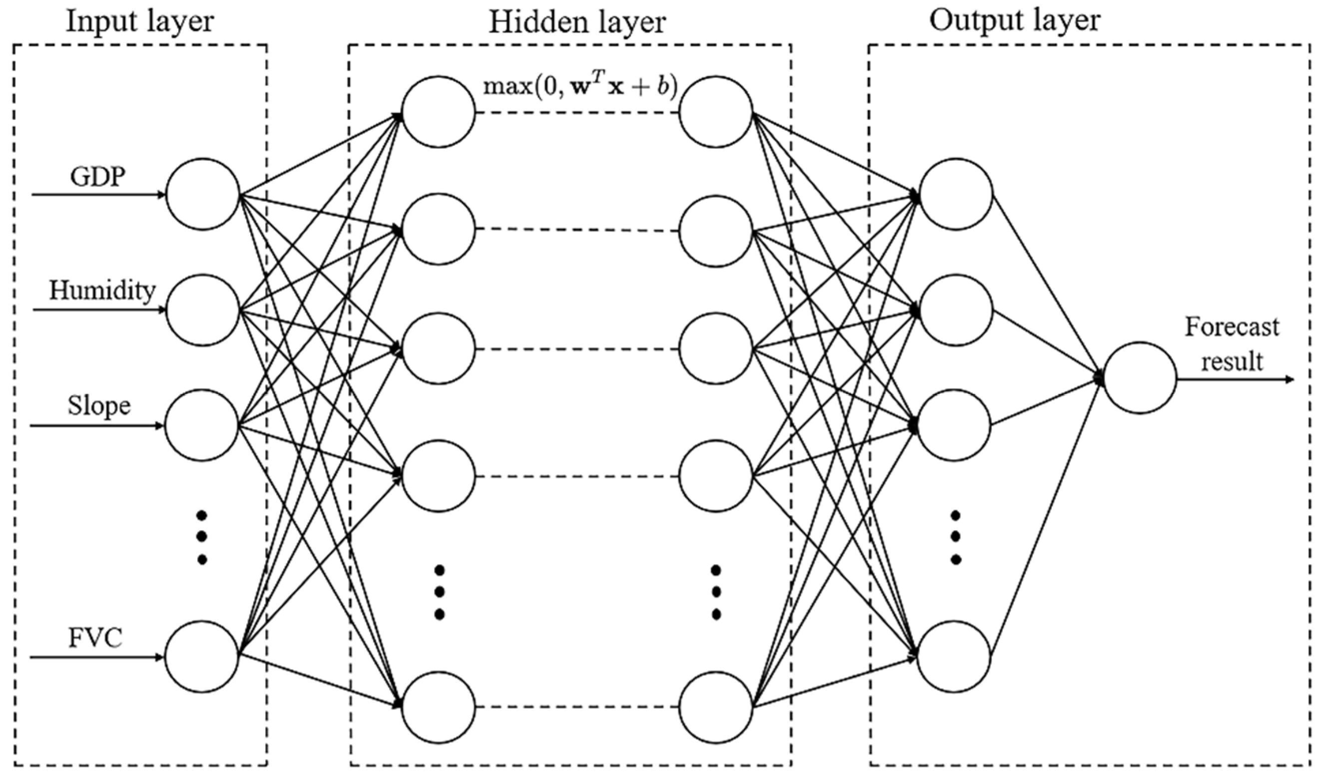
2.3.4. Forest Fire Probability Prediction

Although there are many researchers using logistic regression to predict the occurrence of forest fires. However, studies have shown that there is a nonlinear relationship between fire drivers and the occurrence of forest fires, and nonparametric models are more suitable for predicting the occurrence of forest fires [35]. Therefore, for the forest ecosystems in the four provinces of Heilongjiang, Liaoning, Jilin, and Hebei, we also modelled the probability of forest fires based on the artificial neural network system shown in Figure 4. To reduce the implicit transformations that appear in the model, we preprocessed the data and extracted fire data from NPP and Landsat satellite products using the NBR index, aiming to exclude outliers present in the data. Data preprocessing is an important step in artificial neural network modelling. It is divided into two steps: normalization of the dataset and splitting of the dataset. For the first step of processing, we chose to normalize the dataset to the interval 0–1. For the second step, we chose to split the four-province dataset into two parts according to the random principle. The full dataset was split and 70% (3232 pixels in total) of the data was used for training the model and the remaining 30% (1385 pixels in total) was used for model validation. To avoid model overfitting and effectively reduce the model training time, we constructed artificial neural network (ANN) systems with two hidden layers of 64 and 42 nodes to predict the probability of forest fires in different forest ecosystems in China. The middle hidden layer of ANN uses the “relu” function, which is an activation function commonly used in neural networks, and its convergence speed is fast, effectively reducing the operation time. The output layer uses the “sigmoid” function; the output of this function is continuous and not scattered, which is conducive to subsequent processing and analysis of the results. We combined different types of variables and constructed and trained models to explore the comprehensive effects of different combinations of factors on the occurrence of fires in different forest ecosystems.
In order to verify the applicability and universality of the created model, three indicators of Precision, Recall, and F-measure index were added as the accuracy evaluation criteria in this study. In previous research, these metrics were commonly used to analyze forest fire prediction accuracy issues [61], with the aim of describing the predictions of the models created. The value range of each evaluation index is 0–1, and the closer it is to 1, the higher the prediction accuracy of the model. Precision is a measure of debugging error, referring to the fact that the model created predicts the occurrence of forest fires. The formula is defined as follows (Equation (6)):
P r e c i s i o n = T P T P + F P
Recall is the forgetting rate, meaning that there was a forest fire in the analyzed cells, but no fire was predicted, the formula is defined as (Equation (7)):
R e c a l l = T P T P + F N  
The F-measure index is the weighted sum average of Precision and Recall, which combines the results of Precision and Recall. The formula definition is shown in (Equation (8)):
F m e a s u r e = 2 × P r e c i s i o n × R e c a l l P r e c i s i o n + R e c a l l  
In Equations (6) and (7), TP is the number of correctly predicted forest fires, FP is the number of incorrectly predicted fires, and FN is the number of grids predicted to be non-fires, but there are actually forest fires.

3. Results

3.1. Spatial Pattern and Fire Hotspot Analysis

We calculated the K function from 2019 to 2021 and used the sum density analysis method to perform hotspot analysis on the fire points in the study area to reflect the spatial clustering distribution area and pattern of fire more intuitively. The results based on multidistance spatial clustering analysis showed (Figure 5) that the L(d) values of Heilongjiang, Jilin, Liaoning, and Hebei from 2019 to 2021 were larger than expected and larger than the upper packet tracking. This indicated that forest fires in all four provinces from 2019 to 2021 showed a significant spatially clustered distribution.
The image shows the forest fire hotspots in the four provinces of Heilongjiang, Jilin, Liaoning, and Hebei from 2019 to 2021 (Figure 5). As shown in Figure 6a–c, the Hegang Forest Farm was the hotspot in Heilongjiang Province in 2019, and there were two major fire hotspots in Heilongjiang Province in 2020, the forest areas under the jurisdiction of the cities of Mudanjiang and Jiamusi. In 2021, the only fire hotspot in Heilongjiang was the Mudanjiang forest area. As shown in Figure 6b–d, the fire hotspots in Jilin Province in 2019 were forest farms in the cities of Jilin, Changchun, and Tonghua. In 2020, the hotspots were Tonghua and Changchun Forest Farm. The hotspots in 2021 were the jurisdictional forest farms in Tonghua, Jilin, and Yanji, with fewer fires under the jurisdiction of Changchun and an increase in the number of fires in Jilin and Yanji. Figure 6g–i show that the fire hotspot in Liaoning Province in 2019 was in the Fushun Forest Farm, while the fire hotspots in 2020 and 2021 were the forest areas under the jurisdiction of the cities of Dalian and Tieling, respectively. Based on Figure 6j–l, we also found that the fire hotspot in Hebei in 2019 was the Tangshan forest farm, while the hotspots in 2020 were the forest farms in Chengde and Shijiazhuang, and in 2021, the forest farms were under the jurisdiction of the cities of Qinhuangdao, Zhangjiakou, and Chengde.

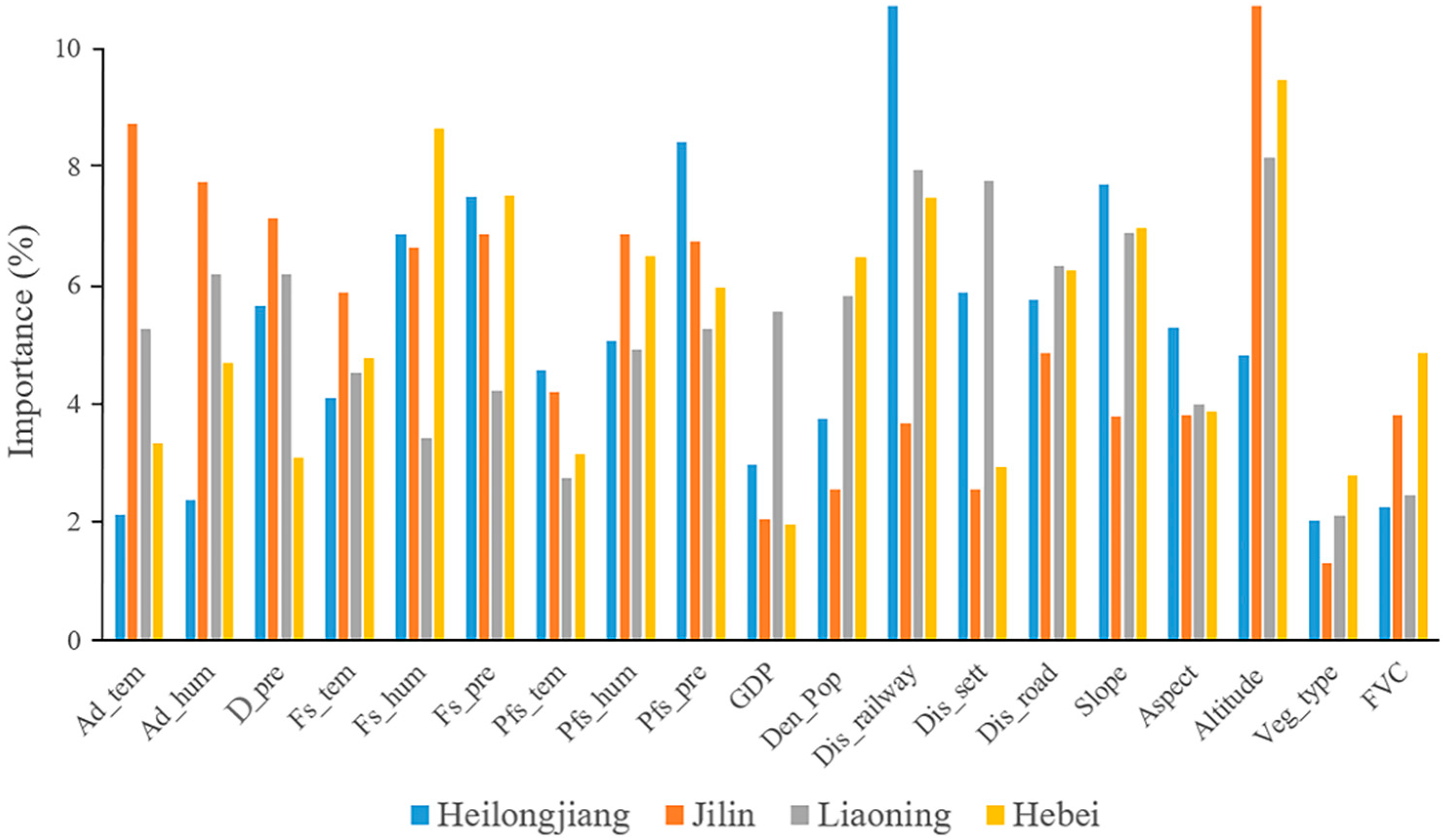
3.2. Comparison of the Effects of Climatic Factors on Forest Fires

In this study, the 9 climatic factors were used in the training of the artificial neural network model to explore the influence of meteorological factors on the occurrence of fires in different forest ecosystems. To achieve this goal, we created four intermediate models based on subsamples of the dataset as well as different study areas. We chose to use 70% of the data for training and the rest for model validation, and use only climatic factors to train the artificial neural network. It can be found that compared with the other three provinces, meteorological factors have the greatest impact on Jilin and predicted 81.02% of the forest fires in Jilin Province (Table 3).
In addition, the results of the LightGBM algorithm (Figure 7) showed that, compared with other climatic factors, the three variables related to precipitation were more important for fire occurrence in the forest area of Heilongjiang Province.

3.3. Comparison of Topographic Factors and Vegetation Factors on Forest Fires

In this study, only two vegetation factors and three terrain factors were considered. Because there are few variables, the use of vegetation factor or terrain factor alone will affect the model prediction accuracy of forest fire occurrence, and will also affect the conclusion of variable importance analysis. We chose to combine topographic factors and vegetation factors to explore the impact of the two types of factors on the occurrence of forest ecosystem fires in the four different provinces. We used 5 topographic factors along with the vegetation factors to train the artificial neural network and created four intermediate models. Based on the results of model training, topographic factors and vegetation factors predicted the occurrence of 87.89% of forest fires in Hebei (Table 4). In contrast, these two types of factors are less important in the other three provinces and only predict 66.1% of forest fires in Liaoning.
We used the LightGBM algorithm to analyze the importance of these two types of factors (Figure 8), and the results showed that the overall impact of topographic factors on forest fires was greater than that of vegetation factors. The influence of altitude was the most important variable for the three study areas of Jilin, Liaoning, and Hebei, but for the Heilongjiang forest area, the slope was the most significant variable.
On this basis, we also extracted and analyzed the combustibles of the historical fire data in the four provinces. The aim is to rank the 16 types of combustibles used in this study. Figure 9 shows the proportion of historical fire occurrences for 16 different types of combustibles. The results show that when the forest combustibles code is 10, the number of forest fires is the most, accounting for 13.97% of the whole dataset. Followed by code 2 and code 8, accounting for 7.72% and 7.35%, respectively. In contrast, the proportions of code 7, 5, 11, 9, and 6 are relatively low, 4.48%, 2.45%, 2.21%, 1.38%, and 1.21%, respectively. The remaining combustible types account for less than 1%, and the proportion of code 4 is 0. (The codes are the same as those in Section 2.2.2)

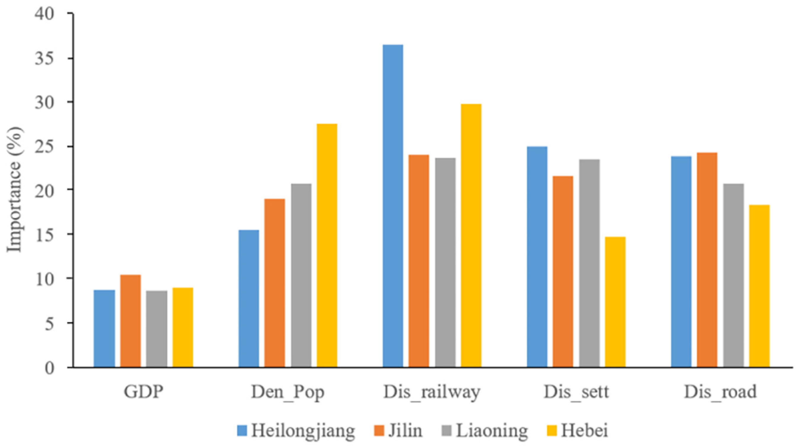
3.4. Comparison of the Influence of Human Factors on Forest Fires

In this study, to explore the impact of human factors on different study areas, the five selected human factors were used to train ANN models of forest fires in the four provinces. Table 5 shows the prediction results of the four intermediate models we created. The results indicated that human drivers had similar effects on forest fire occurrence in the four provinces. However, the model predicted 86.14% of forest fires in Heilongjiang, which shows that compared with the other three provinces, human drivers had the most significant impact on Hebei.
The results of the LightGBM algorithm showed that in Heilongjiang, Liaoning, and Hebei Provinces, the distance from the point to the railway was the most important driving factor affecting the occurrence of forest fires in these three provinces (Figure 10). In contrast, the impact of GDP and population density on the occurrence of forest fires in the four provinces was low.

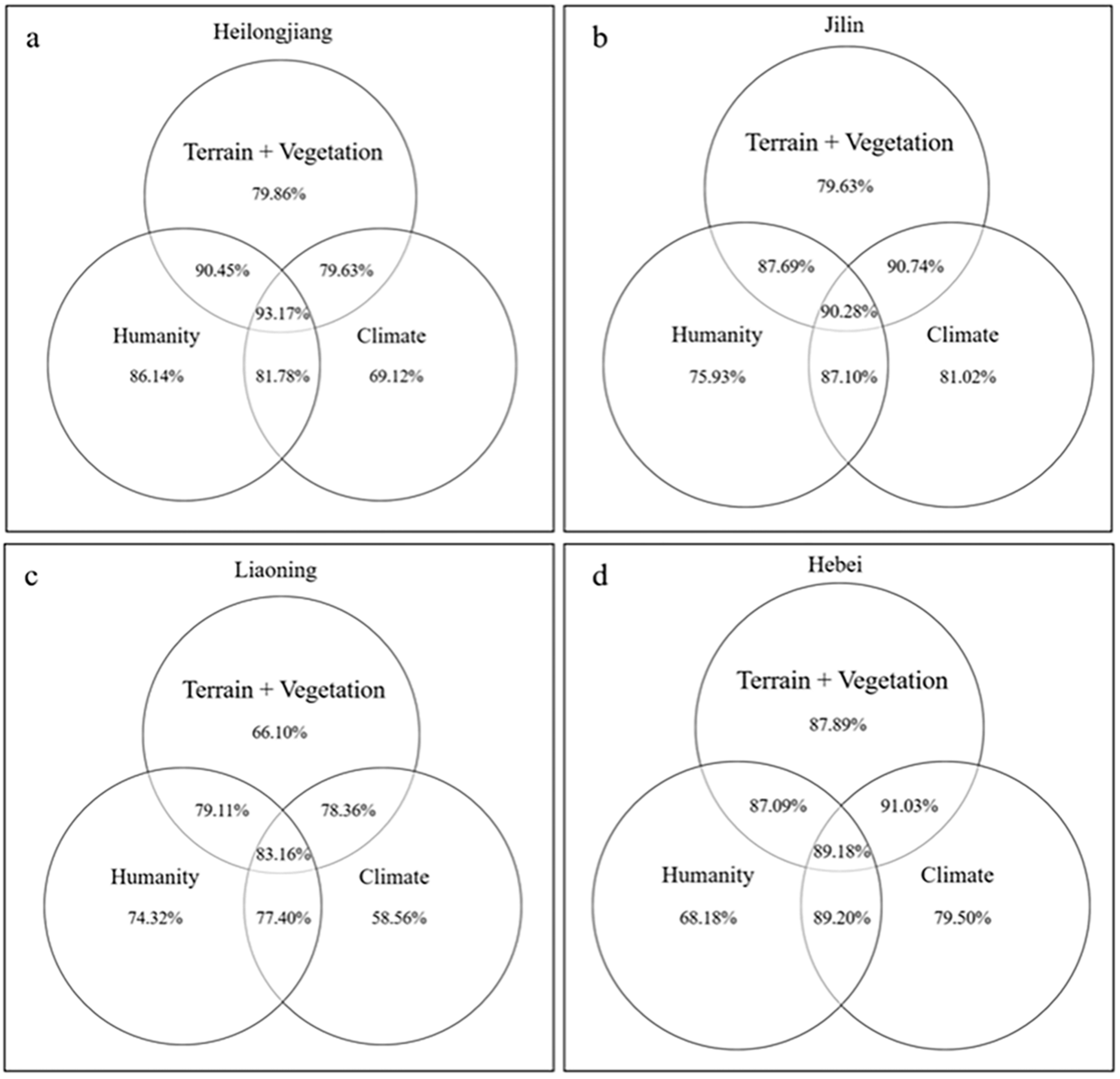
3.5. Comparison of the Influence of Comprehensive Factors on Forest Fire Occurrence

We used the LightGBM method to assess the variable importance of combined factors. As shown in Figure 11, several variables were identified as significant drivers of forest fires in the four provinces, including closest distance to railways, daily precipitation, average humidity, and average precipitation during the fire season (year before and year of fire). In contrast, the overall importance of vegetation factors was low.
We also simulated the probability of the occurrence forest fires in the four provinces in China based on the full dataset and all fire-related variables. According to Figure 12, the forest fire prediction accuracies for the four provinces of Heilongjiang, Jilin, Liaoning, and Hebei were 93.17%, 90.28%, 83.16%, and 89.18%, respectively. As seen in the figure, the importance of vegetation factors and topographic factors for modelling the occurrence of fires in the four provinces was generally high. Human factors were the most important driving factors for forest fires in Heilongjiang, Jilin, and Liaoning.
The model performance of the created ANN models is shown in Table 6. It can be seen from the table that the three evaluation indicators are relatively high. The value ranges of the three indicators are all in the interval of 0–1. The larger the indicator, the better the model performance. This also shows the reliability and validity of the model.

4. Discussion

4.1. Spatial and Temporal Patterns and Hotspot Analysis of Different Forest Ecosystems

Based on the results of the analysis, the distribution of fire points in each province showed significant clustering; this finding is similar to previous research results [5]. Through kernel density analysis, the hotspots in each province where the fire points were more densely distributed were obtained. In the Heilongjiang forest area, the fire hotspots were mainly in the central and southern areas, specifically, in the forest areas of Hegang, Mudanjiang, and Jiamusi. Studies have shown that most of the forests in these jurisdictional areas are made up of flammable coniferous forest species and they have lower humidity than other areas [49] which also leads to an increase in forest fires [28,62]. The fire hotspots in Jilin were concentrated in the southern part of the study area, which may be because the southern part of the province is relatively low in altitude, only approximately 100 m to 500 m. Lower altitudes have relatively higher temperatures, lower humidity, and more frequent human activities, leading to an increased likelihood of forest fires [15,59]. There were many forest fires in the Tieling, Dalian, and Fushun areas in Liaoning, and fire disturbance mainly occurred in spring. This is because most of the vegetation in these areas is flammable vegetation, such as shrubs, and in spring, the temperature in these areas rises faster and there is less rainfall. In Hebei, the main fire hotspot was in the northeast of the forest area. Compared with other provinces, the topography of forest areas in Hebei Province is relatively complex, which also causes the generation of microclimates in the forests, thus promoting the occurrence of forest fires [63].

4.1.1. Comparison of the Effects of Variables on Fire Occurrence in Different Forest Ecosystems

In the context of frequent fires, it is crucial to conduct in-depth research on the drivers of forest fires in different forest ecosystems in China and to effectively predict forest fires [64,65,66]. In our research, we found that there were obvious differences in the explanatory variables in the four different provinces in China. Previous studies [11,32] showed that, due to the continuous development of the social economy, an increasing number of people leave the city and enter the forest areas in Heilongjiang and Liaoning Provinces. The occurrence of fire is mainly influenced by human-driven factors, of which the shortest distance from the fire point to the man-made surface structure (railway, road, settlement) was identified as the most important influencing factor. Meteorological factors were the most important factors influencing forest fires in Jilin Province; this finding was consistent with the results of previous studies [56]. Among the meteorological factors, the average temperature and average humidity on the day of the fire were the most influential. The combined effect of topographic and vegetation factors on forest fires in Hebei Province was greater than the effect of human factors and climatic factors, and the importance of topographical factors was higher than that of vegetation factors [63].

4.1.2. The Effect of Climate Variables on Fire Occurrence

Among the climatic factors, variables related to precipitation (the precipitation on the day of the fire, the average precipitation in the fire season, and the average precipitation in the fire season in the previous year) were important meteorological driving factors for the occurrence of forest fires in Heilongjiang Province and Liaoning. Previous studies [55,67] have shown that greater amounts of precipitation increased the moisture content of combustibles in forests and reduced or even prevented forest fires [68,69,70]. The average temperature on the day of the fire, the average temperature in the fire season, and the average humidity in the fire season were also important. For Jilin, the average temperature, humidity, and precipitation on the day of the fire exhibited greater variable importance than other meteorological factors. This may be due to the large meteorological fluctuations in Jilin [71]; the average meteorological data during the fire season cannot explain the occurrence of forest fires well. The average humidity in the fire season was the most important variable influencing the occurrence of forest fires in Hebei Province. Some studies have shown that the temperature in Hebei tended to decrease in the mid to late August, but the humidity in the forest area was still high, and there was frequent light precipitation [72]. In these conditions, the water content of the combustibles was also relatively high. Since a large amount of heat is consumed by the evaporation of water during heating, the temperature of wet combustibles does not easily rise to the ignition point quickly [73]. Although it is widely believed that high temperatures sharply decrease the moisture content of forest combustibles, thereby increasing the probability of forest fires, studies have shown that extremely high temperatures may hinder the occurrence of forest fires [73]. This may be because there is a certain threshold relationship between air temperature and fire occurrence [17,74]; it is also possible that under high temperature conditions, local forestry managers and firefighters are more vigilant regarding fire prevention.

4.1.3. Effects of Topographic and Vegetation Factors on Fire Occurrence

The combination of topographic factors and vegetation factors had important effects on the occurrence of forest fires in the four provinces. For the three provinces of Jilin, Liaoning, and Hebei, altitude was the most important among the topographic factors. Elevation has also been previously identified as an important driver of forest fires [27,28,31,44,75]. The higher the altitude is, the lower the humidity in the forest, the higher the relative humidity, the higher the moisture content of the ground cover, and the less likely it is to burn [26,35]. There have also been studies showing that there is less human activity at high altitudes, so the possibility of anthropogenic ignition is much lower than that at low altitudes [76]. Figure 8 shows that slope was the most important topographic variable for the occurrence of forest fires in Heilongjiang. This may be because the Heilongjiang forest area is more uniform in altitude than Jilin and other areas, and there are few large topographical fluctuations. When the terrain is flat, the solar radiation is more uniform and has a smaller effect on the occurrence of forest fires [45,77]. Similar to previous studies, in the case of the same type of combustibles, the probability of large-slope forest fires is greater [78]. The contribution of the variable representing vegetation type to the occurrence of forest fires in the four provinces was almost the same, and the overall contribution was not as large as that of FVC. This finding is consistent with the results of previous studies [79,80,81]; it may be because FVC can directly reflect the amount of fuel per unit area, and the amount of fuel will directly affect the occurrence of forest fires.
In addition, through the fuel type analysis of historical fire points, this study found that seasonal flammable forest combustibles (code 10) are the type that causes the most forest fires among the 16 types of combustibles. Such findings are similar to previous studies [81], which may be because the area of seasonal flammable forest combustibles is larger in these four provinces, and the probability of forest fires increases accordingly. However, what is interesting is that the area of medium combustible forest combustibles (code 3) is also relatively large, but the proportion of fires caused by combustibles in this forest is relatively low. This may be because the moisture content of this combustible type is relatively high, which can prevent some forest fires from occurring [82,83].

4.1.4. Influence of Human Factors on Fire Occurrence

Previous studies have shown that population density is a crucial variable affecting the occurrence of forest fires [30,44,84]. However, as seen in Figure 10, we found that the contribution of the population density variable to the occurrence of forest fires in the Heilongjiang forest area was low. This may be because, with increasing urbanization, the population is mostly concentrated in more industrialized urban areas, which are often far from forested areas. Similar to previous findings [31,69,85] regarding the relationship between fire points and artificial surface structures, such as railways and roads, the closest distance variable exhibited high importance in the analysis of forest fires in the four provinces (Figure 10). This may be because, with the construction of highways and railways in China, human surface structures are getting closer and closer to the forest, which leads to an increase in the probability of forest fires. On the other hand, the complicated road patterns in Hebei can lead to the disruption of continuous fuel in the forest area and the lack of continuous vegetation. Therefore, the importance of the shortest distance from the fire point to the highway was lower than that in the analysis of data from other provinces [56].

4.2. Implications for Forest Fire Management

We found large differences in the importance of forest fire drivers among the four provinces. In the forest areas of Heilongjiang and Liaoning, human factors were the most important variables affecting the occurrence of forest fires. In contrast, meteorological factors had the greatest impact on forest fires in Jilin, while topographic and vegetation factors had the greatest contribution to forest fire occurrence in Hebei. Due to this spatial variability, local forest management and fire prevention policies should be developed for different regions within the study area.
Until now, most forest fire prediction studies only predicted probability of fires based on meteorological factors [86,87,88,89], but this approach is not sufficient for all regions. Therefore, in this study, we also constructed an ANN model to predict the probability of occurrence of forest fires in the four provinces for the entire dataset collected. The constructed model predicted 93.17%, 90.28%, 83.16%, and 89.18% of the fires in Heilongjiang, Jilin, Liaoning, and the Hebei forest area, respectively. On this basis, we also use new evaluation metrics to demonstrate the reliability and stability of the model. It can be found from Table 6 that the overall Precision, Recall, and F-measure indices of the created ANN model for the four provinces are 0.87, 0.88, and 0.87, respectively. This also explains the high performance and stability of the created models.

4.3. Limitations

The selected human factors exhibited similar variable importance in the four provinces. This implies that, with the continuous development of China’s economy, the economic development of different study areas will have similar impacts on the occurrence of forest fires in different forest ecosystems. Studies have shown that as China’s economy continues to develop, the impact of human drivers on forest fires will increase. Electricity consumption in forest areas and the education level of forest practitioners will indirectly affect the occurrence of forest fires [55,89]. Therefore, further attention should be given to these variables, and new variables should be assessed to help guide modern forest management.

5. Conclusions

In this study, we used Ripley’s K(d) function and kernel density analysis to determine the spatial pattern of fires and fire hotspots in forest areas in four different provinces in China. In addition, we used the LightGBM algorithm to determine the relative impact of various fire-influencing factors on forest fires in different spatial regions. Four types of variables (climatic factors, topographic factors, vegetation factors, and human drivers) were used as input to the artificial neural network model we created to predict the probability of the occurrence of forest fires. The results of the study showed that from 2019 to 2021, the occurrence of fires in the four provinces was clustered, and the driving factors differed. The forest fires in Heilongjiang and Liaoning Provinces were mainly caused by human factors, among which the artificial surface structure was identified as the most critical factor. Climatic factors were identified as the most critical driving factors of forest fires in Jilin Province, among which the average temperature on the day of the fire was the most important. In contrast, topographic factors, specifically altitude, had a greater impact on forest fires in Hebei. The combined factor predicted 93.17% and 83.16% of the fires in Heilongjiang and the Liaoning forest areas, respectively, and the human factor independently predicted 86.14% and 74.32%, respectively. The combined factor predicted 90.28% of forest fires in Jilin Province, and the meteorological factor independently predicted 81.02%. The combined factor predicted 89.20% of the occurrence of forest fires in Hebei. We concluded that the occurrence of forest fires is a natural phenomenon caused by multiple factors, and different forest fire fighting and forestry management strategies must be adopted for different regions. This study also provides new ideas for the analysis of the spatial pattern of fire protection work, and these results can provide an effective theoretical basis and help guide the configuration of forest fire protection and forestry management. Due to the rapid social and economic development in China, the impact of human factors on forest fires will continue to increase. In future work, we will expand the time span and study area of the analysis and provide information for modern forest management and fire management assistance.

Author Contributions

Conceptualization, M.L. and B.W.; methodology, B.W.; software, Z.W.; validation, Y.T.; formal analysis, J.L.; investigation, B.W. and Y.T.; resources, M.L.; data curation, M.L. and B.W.; writing—original draft preparation, Z.W.; writing—review and editing, B.W.; visualization, Y.Q.; supervision, Y.Q.; project administration, B.W.; funding acquisition, M.L. All authors have read and agreed to the published version of the manuscript.

Funding

This study was financially supported by the University of Science and Technology of China (2020YFC1511603), Fundamental Research Funds for the Central Universities (2572020BA07).

Data Availability Statement

Due to the nature of this research, participants of this study did not agree for their data to be shared publicly, so supporting data is not available.

Conflicts of Interest

The authors declare no conflict of interest.

References

  1. Johnstone, J.F.; Allen, C.D.; Franklin, J.F.; Frelich, L.E.; Harvey, B.J.; Higuera, P.E.; Mack, M.C.; Meentemeyer, R.K.; Metz, M.R.; Perry, G.L.W. Changing disturbance regimes, ecological memory, and forest resilience. Front. Ecol. Environ. 2016, 14, 369–378. [Google Scholar] [CrossRef]
  2. Molina, J.R.; Herrera, M.A.; Rodríguez y Silva, F. Wildfire-induced reduction in the carbon storage of Mediterranean ecosystems: An application to brush and forest fires impacts assessment. Environ. Impact Assess. Rev. 2019, 76, 88–97. [Google Scholar] [CrossRef]
  3. Argañaraz, J.P.; Radeloff, V.C.; Bar-Massada, A.; Gavier-Pizarro, G.I.; Scavuzzo, C.M.; Bellis, L.M. Assessing wildfire exposure in the Wildland-Urban Interface area of the mountains of central Argentina. J. Environ. Manag. 2017, 196, 499–510. [Google Scholar] [CrossRef] [PubMed]
  4. Modugno, S.; Balzter, H.; Cole, B.; Borrelli, P. Mapping regional patterns of large forest fires in Wildland–Urban Interface areas in Europe. J. Environ. Manag. 2016, 172, 112–126. [Google Scholar] [CrossRef]
  5. San-Miguel-Ayanz, J.; Moreno, J.M.; Camia, A. Analysis of large fires in European Mediterranean landscapes: Lessons learned and perspectives. For. Ecol. Manag. 2013, 294, 11–22. [Google Scholar] [CrossRef]
  6. Kizilkaya, B.; Ever, E.; Yatbaz, H.Y.; Yazici, A. An Effective Forest Fire Detection Framework Using Heterogeneous Wireless Multimedia Sensor Networks. ACM Trans. Multimed. Comput. Commun. Appl. 2022, 18, 1–21. [Google Scholar] [CrossRef]
  7. Yang, G.; Shu, L.F.; Sun, S.Q.; Di, X.Y.; Liu, C. Temporal-spatial distribution regularities of forest fire casualties in China. J. Catastrophology 2015, 30, 21–25. [Google Scholar]
  8. Hering, A.S.; Bell, C.L.; Genton, M.G. Modeling spatio-temporal wildfire ignition point patterns. Environ. Ecol. Stat. 2009, 16, 225–250. [Google Scholar] [CrossRef]
  9. Moreira, F.; Ascoli, D.; Safford, H.; Adams, M.A.; Moreno, J.M.; Pereira, J.M.C.; Catry, F.X.; Armesto, J.; Bond, W.; González, M.E. Wildfire management in Mediterranean-type regions: Paradigm change needed. Environ. Res. Lett. 2020, 15, 11001. [Google Scholar] [CrossRef]
  10. Twidwell, D.; Wonkka, C.L.; Wang, H.-H.; Grant, W.E.; Allen, C.R.; Fuhlendorf, S.D.; Garmestani, A.S.; Angeler, D.G.; Taylor Jr, C.A.; Kreuter, U.P. Coerced resilience in fire management. J. Environ. Manag. 2019, 240, 368–373. [Google Scholar] [CrossRef]
  11. Guo, F.; Innes, J.L.; Wang, G.; Ma, X.; Sun, L.; Hu, H.; Su, Z. Historic distribution and driving factors of human-caused fires in the Chinese boreal forest between 1972 and 2005. J. Plant Ecol. 2015, 8, 480–490. [Google Scholar] [CrossRef]
  12. Avila-Flores, D.; Pompa-Garcia, M.; Antonio-Nemiga, X.; Rodriguez-Trejo, D.A.; Vargas-Perez, E.; Santillan-Perez, J. Driving factors for forest fire occurrence in Durango State of Mexico: A geospatial perspective. Chin. Geogr. Sci. 2010, 20, 491–497. [Google Scholar] [CrossRef]
  13. Oliveira, S.; Oehler, F.; San-Miguel-Ayanz, J.; Camia, A.; Pereira, J.M.C. Modeling spatial patterns of fire occurrence in Mediterranean Europe using Multiple Regression and Random Forest. For. Ecol. Manag. 2012, 275, 117–129. [Google Scholar] [CrossRef]
  14. Collins, K.M.; Price, O.F.; Penman, T.D. Spatial patterns of wildfire ignitions in south-eastern Australia. Int. J. Wildland Fire 2015, 24, 1098–1108. [Google Scholar] [CrossRef]
  15. Wu, Z.; Li, M.; Wang, B.; Quan, Y.; Liu, J. Using artificial intelligence to estimate the probability of forest fires in Heilongjiang, northeast China. Remote Sens. 2021, 13, 1813. [Google Scholar] [CrossRef]
  16. Ganteaume, A.; Camia, A.; Jappiot, M.; San-Miguel-Ayanz, J.; Long-Fournel, M.; Lampin, C. A review of the main driving factors of forest fire ignition over Europe. Environ. Manag. 2013, 51, 651–662. [Google Scholar] [CrossRef]
  17. Castro, F.X.; Tudela, A.; Sebastià, M.T. Modeling moisture content in shrubs to predict fire risk in Catalonia (Spain). Agric. For. Meteorol. 2003, 116, 49–59. [Google Scholar] [CrossRef]
  18. Zeng, A.; Yang, S.; Zhu, H.; Tigabu, M.; Su, Z.; Wang, G.; Guo, F. Spatiotemporal Dynamics and Climate Influence of Forest Fires in Fujian Province, China. Forests 2022, 13, 423. [Google Scholar] [CrossRef]
  19. Rollins, M.G.; Morgan, P.; Swetnam, T. Landscape-scale controls over 20th century fire occurrence in two large Rocky Mountain (USA) wilderness areas. Landsc. Ecol. 2002, 17, 539–557. [Google Scholar] [CrossRef]
  20. Xiao-Ying, W.; Chun-Yu, Z.; Qing-Yu, J. Impacts of climate change on forest ecosystems in Northeast China. Adv. Clim. Chang. Res. 2013, 4, 230–241. [Google Scholar] [CrossRef]
  21. Sharples, J.J. An overview of mountain meteorological effects relevant to fire behaviour and bushfire risk. Int. J. Wildland Fire 2009, 18, 737–754. [Google Scholar] [CrossRef]
  22. Westerling, A.L.; Hidalgo, H.G.; Cayan, D.R.; Swetnam, T.W. Warming and earlier spring increase western US forest wildfire activity. Science 2006, 313, 940–943. [Google Scholar] [CrossRef]
  23. Archibald, S.; Roy, D.P.; van Wilgen, B.W.; Scholes, R.J. What limits fire? An examination of drivers of burnt area in Southern Africa. Glob. Chang. Biol. 2009, 15, 613–630. [Google Scholar] [CrossRef]
  24. Mundo, I.A.; Wiegand, T.; Kanagaraj, R.; Kitzberger, T. Environmental drivers and spatial dependency in wildfire ignition patterns of northwestern Patagonia. J. Environ. Manag. 2013, 123, 77–87. [Google Scholar] [CrossRef]
  25. Penman, T.D.; Bradstock, R.A.; Price, O. Modelling the determinants of ignition in the Sydney Basin, Australia: Implications for future management. Int. J. Wildland Fire 2012, 22, 469–478. [Google Scholar] [CrossRef]
  26. Han, J.; Shen, Z.; Ying, L.; Li, G.; Chen, A. Early post-fire regeneration of a fire-prone subtropical mixed Yunnan pine forest in Southwest China: Effects of pre-fire vegetation, fire severity and topographic factors. For. Ecol. Manag. 2015, 356, 31–40. [Google Scholar] [CrossRef]
  27. Guo, F.; Su, Z.; Wang, G.; Sun, L.; Lin, F.; Liu, A. Wildfire ignition in the forests of southeast China: Identifying drivers and spatial distribution to predict wildfire likelihood. Appl. Geogr. 2016, 66, 12–21. [Google Scholar] [CrossRef]
  28. Guo, F.; Wang, G.; Su, Z.; Liang, H.; Wang, W.; Lin, F.; Liu, A. What drives forest fire in Fujian, China? Evidence from logistic regression and Random Forests. Int. J. Wildland Fire 2016, 25, 505–519. [Google Scholar] [CrossRef]
  29. Chen, F.; Du, Y.; Niu, S.; Zhao, J. Modeling forest lightning fire occurrence in the Daxinganling Mountains of Northeastern China with MAXENT. Forests 2015, 6, 1422–1438. [Google Scholar] [CrossRef]
  30. Sturtevant, B.R.; Cleland, D.T. Human and biophysical factors influencing modern fire disturbance in northern Wisconsin. Int. J. Wildland Fire 2007, 16, 398–413. [Google Scholar] [CrossRef]
  31. Miranda, B.R.; Sturtevant, B.R.; Stewart, S.I.; Hammer, R.B. Spatial and temporal drivers of wildfire occurrence in the context of rural development in northern Wisconsin, USA. Int. J. Wildland Fire 2011, 21, 141–154. [Google Scholar] [CrossRef]
  32. Wu, Z.; He, H.S.; Yang, J.; Liu, Z.; Liang, Y. Relative effects of climatic and local factors on fire occurrence in boreal forest landscapes of northeastern China. Sci. Total Environ. 2014, 493, 472–480. [Google Scholar] [CrossRef] [PubMed]
  33. FENG, Q.-s.; XIU, L.-n.; LIANG, T.-g. Distribution of the existing natural vegetation in China based on CSCS. Acta Prataculturae Sin. 2013, 22, 16. [Google Scholar]
  34. Liu, Z.; Yang, J.; Chang, Y.; Weisberg, P.J.; He, H.S. Spatial patterns and drivers of fire occurrence and its future trend under climate change in a boreal forest of Northeast China. Glob. Chang. Biol. 2012, 18, 2041–2056. [Google Scholar] [CrossRef]
  35. Zhang, J.-H.; Yao, F.-M.; Liu, C.; Yang, L.-M.; Boken, V.K. Detection, emission estimation and risk prediction of forest fires in China using satellite sensors and simulation models in the past three decades—An overview. Int. J. Env. Res. Pub. He. 2011, 8, 3156–3178. [Google Scholar] [CrossRef]
  36. Sukitpaneenit, M.; Kim Oanh, N.T. Satellite monitoring for carbon monoxide and particulate matter during forest fire episodes in Northern Thailand. Environ. Monit. Assess. 2014, 186, 2495–2504. [Google Scholar] [CrossRef]
  37. Feng, L.; Xiao, H.; Yang, Z.; Zhang, G. A Multiscale Normalization Method of a Mixed-Effects Model for Monitoring Forest Fires Using Multi-Sensor Data. Sustainability 2022, 14, 1139. [Google Scholar] [CrossRef]
  38. Roy, D.P.; Boschetti, L.; Trigg, S.N. Remote sensing of fire severity: Assessing the performance of the normalized burn ratio. IEEE Geosci. Remote Sens. Lett. 2006, 3, 112–116. [Google Scholar] [CrossRef]
  39. Epting, J.; Verbyla, D.; Sorbel, B. Evaluation of remotely sensed indices for assessing burn severity in interior Alaska using Landsat TM and ETM+. Remote Sens. Environ. 2005, 96, 328–339. [Google Scholar] [CrossRef]
  40. Escuin, S.; Navarro, R.; Fernandez, P. Fire severity assessment by using NBR (Normalized Burn Ratio) and NDVI (Normalized Difference Vegetation Index) derived from LANDSAT TM/ETM images. Int. J. Remote Sens. 2008, 29, 1053–1073. [Google Scholar] [CrossRef]
  41. Catry, F.X.; Rego, F.C.; Bação, F.L.; Moreira, F. Modeling and mapping wildfire ignition risk in Portugal. Int. J. Wildland Fire 2009, 18, 921–931. [Google Scholar] [CrossRef]
  42. Chang, Y.; Zhu, Z.; Bu, R.; Chen, H.; Feng, Y.; Li, Y.; Hu, Y.; Wang, Z. Predicting fire occurrence patterns with logistic regression in Heilongjiang Province, China. Landsc. Ecol. 2013, 28, 1989–2004. [Google Scholar] [CrossRef]
  43. Pereira, M.G.; Trigo, R.M.; da Camara, C.C.; Pereira, J.M.C.; Leite, S.M. Synoptic patterns associated with large summer forest fires in Portugal. Agric. For. Meteorol. 2005, 129, 11–25. [Google Scholar] [CrossRef]
  44. Syphard, A.D.; Radeloff, V.C.; Keuler, N.S.; Taylor, R.S.; Hawbaker, T.J.; Stewart, S.I.; Clayton, M.K. Predicting spatial patterns of fire on a southern California landscape. Int. J. Wildland Fire 2008, 17, 602–613. [Google Scholar] [CrossRef]
  45. Herawati, H.; González-Olabarria, J.R.; Wijaya, A.; Martius, C.; Purnomo, H.; Andriani, R. Tools for assessing the impacts of climate variability and change on wildfire regimes in forests. Forests 2015, 6, 1476–1499. [Google Scholar] [CrossRef]
  46. Littell, J.S.; McKenzie, D.; Peterson, D.L.; Westerling, A.L. Climate and wildfire area burned in western US ecoprovinces, 1916–2003. Ecol. Appl. 2009, 19, 1003–1021. [Google Scholar] [CrossRef]
  47. Clarke, P.J.; Knox, K.J.E.; Bradstock, R.A.; Munoz-Robles, C.; Kumar, L. Vegetation, terrain and fire history shape the impact of extreme weather on fire severity and ecosystem response. J. Veg. Sci. 2014, 25, 1033–1044. [Google Scholar] [CrossRef]
  48. Sharples, J.J.; McRae, R.H.D.; Wilkes, S.R. Wind–terrain effects on the propagation of wildfires in rugged terrain: Fire channelling. Int. J. Wildland Fire 2012, 21, 282–296. [Google Scholar] [CrossRef]
  49. Shu, L.F.; Li, C.J. A relation between forest combustible parameters and stand characteristics. J. Nat. Disasters 2004, 13, 70–75. [Google Scholar]
  50. Comparative Analysis of Fire Detection Algorithms in North China. In Proceedings of the 6th International Symposium of Space Optical Instruments and Applications, Delft, The Netherlands, 24–25 September 2019; Springer: Cham, Switzerland, 2021; pp. 153–169.
  51. Purevdorj, T.S.; Tateishi, R.; Ishiyama, T.; Honda, Y. Relationships between percent vegetation cover and vegetation indices. Int. J. Remote Sens. 1998, 19, 3519–3535. [Google Scholar] [CrossRef]
  52. Gutman, G.; Ignatov, A. The derivation of the green vegetation fraction from NOAA/AVHRR data for use in numerical weather prediction models. Int. J. Remote Sens. 1998, 19, 1533–1543. [Google Scholar] [CrossRef]
  53. Reineking, B.; Weibel, P.; Conedera, M.; Bugmann, H. Environmental determinants of lightning-v. human-induced forest fire ignitions differ in a temperate mountain region of Switzerland. Int. J. Wildland Fire 2010, 19, 541–557. [Google Scholar] [CrossRef]
  54. Zumbrunnen, T.; Pezzatti, G.B.; Menéndez, P.; Bugmann, H.; Bürgi, M.; Conedera, M. Weather and human impacts on forest fires: 100 years of fire history in two climatic regions of Switzerland. For. Ecol. Manag. 2011, 261, 2188–2199. [Google Scholar] [CrossRef]
  55. Stoyan, D.; Penttinen, A. Recent applications of point process methods in forestry statistics. Stat. Sci. 2000, 15, 61–78. [Google Scholar]
  56. Guo, F.; Su, Z.; Wang, G.; Sun, L.; Tigabu, M.; Yang, X.; Hu, H. Understanding fire drivers and relative impacts in different Chinese forest ecosystems. Sci. Total Environ. 2017, 605, 411–425. [Google Scholar] [CrossRef]
  57. Kuter, N.; Yenilmez, F.; Kuter, S. Forest fire risk mapping by kernel density estimation. Croat. J. For. Eng. J. Theory Appl. For. Eng. 2011, 32, 599–610. [Google Scholar]
  58. Flores-Garnica, J.G.; Macías-Muro, A. Bandwidth selection for kernel density estimation of forest fires. Rev. Chapingo Ser. Cienc. For. Y Ambiente 2018, 24, 313–327. [Google Scholar] [CrossRef]
  59. Wu, Z.; Wang, B.; Li, M.; Tian, Y.; Quan, Y.; Liu, J. Simulation of forest fire spread based on artificial intelligence. Ecol. Indic. 2022, 136, 108653. [Google Scholar] [CrossRef]
  60. Meng, Q.; Ke, G.; Wang, T.; Chen, W.; Ye, Q.; Ma, Z.-M.; Liu, T.-Y. A communication-efficient parallel algorithm for decision tree. Adv. Neural Inf. Processing Syst. 2016, 29. [Google Scholar] [CrossRef]
  61. Jain, P.; Coogan, S.C.P.; Subramanian, S.G.; Crowley, M.; Taylor, S.; Flannigan, M.D. A review of machine learning applications in wildfire science and management. Environ. Rev. 2020, 28, 478–505. [Google Scholar] [CrossRef]
  62. Ma, W.; Feng, Z.; Cheng, Z.; Chen, S.; Wang, F. Identifying forest fire driving factors and related impacts in china using random forest algorithm. Forests 2020, 11, 507. [Google Scholar] [CrossRef]
  63. Zhang, J.; Zhang, H.; Tong, Z.; Song, Z.S.; Wu, X.T. Loss assessment and grade partition of grassland fire disaster in Northern China. Acta Pratacult. Sin. 2007, 16, 121. [Google Scholar]
  64. Polinova, M.; Wittenberg, L.; Kutiel, H.; Brook, A. Reconstructing pre-fire vegetation condition in the wildland urban interface (WUI) using artificial neural network. J. Environ. Manag. 2019, 238, 224–234. [Google Scholar] [CrossRef]
  65. Jaafari, A.; Termeh, S.V.R.; Bui, D.T. Genetic and firefly metaheuristic algorithms for an optimized neuro-fuzzy prediction modeling of wildfire probability. J. Environ. Manag. 2019, 243, 358–369. [Google Scholar] [CrossRef]
  66. Song, W.; Weicheng, F.; Binghong, W.; Jianjun, Z. Self-organized criticality of forest fire in China. Ecol. Model. 2001, 145, 61–68. [Google Scholar] [CrossRef]
  67. Chen, F.; Fan, Z.; Niu, S.; Zheng, J. The influence of precipitation and consecutive dry days on burned areas in Yunnan Province, Southwestern China. Adv. Meteorol. 2014, 2014, 748923. [Google Scholar] [CrossRef]
  68. Wotton, B.M.; Martell, D.L.; Logan, K.A. Climate change and people-caused forest fire occurrence in Ontario. Clim. Chang. 2003, 60, 275–295. [Google Scholar] [CrossRef]
  69. Maingi, J.K.; Henry, M.C. Factors influencing wildfire occurrence and distribution in eastern Kentucky, USA. Int. J. Wildland Fire 2007, 16, 23–33. [Google Scholar] [CrossRef]
  70. Chen, F.; Niu, S.; Tong, X.; Zhao, J.; Sun, Y.; He, T. The impact of precipitation regimes on forest fires in Yunnan Province, Southwest China. Sci. World J. 2014, 2014, 326782. [Google Scholar] [CrossRef]
  71. Zhu, B.; Chen, S.; Cao, Y.; Xu, Z.; Yu, Y.; Han, C. A regional maize yield hierarchical linear model combining landsat 8 vegetative indices and meteorological data: Case study in jilin province. Remote Sens. 2021, 13, 356. [Google Scholar] [CrossRef]
  72. Kang, Z.; Gui, H.; Hua, C.; Zhang, B.; Zhang, H.; Lv, M.; Wang, J. National environmental meteorological services in China. Adv. Meteorol. 2016, 2016, 1985207. [Google Scholar] [CrossRef]
  73. Seager, R.; Hooks, A.; Williams, A.P.; Cook, B.; Nakamura, J.; Henderson, N. Climatology, variability, and trends in the US vapor pressure deficit, an important fire-related meteorological quantity. J. Appl. Meteorol. Climatol. 2015, 54, 1121–1141. [Google Scholar] [CrossRef]
  74. Wu, Z.; He, H.S.; Yang, J.; Liang, Y. Defining fire environment zones in the boreal forests of northeastern China. Sci. Total Environ. 2015, 518, 106–116. [Google Scholar] [CrossRef]
  75. Pereira, M.G.; Caramelo, L.; Orozco, C.V.; Costa, R.; Tonini, M. Space-time clustering analysis performance of an aggregated dataset: The case of wildfires in Portugal. Environ. Model. Softw. 2015, 72, 239–249. [Google Scholar] [CrossRef]
  76. Kim, D.-W.; Chung, W.; Lee, B. Exploring tree crown spacing and slope interaction effects on fire behavior with a physics-based fire model. For. Sci. Technol. 2016, 12, 167–175. [Google Scholar] [CrossRef]
  77. Hantson, S.; Lasslop, G.; Kloster, S.; Chuvieco, E. Anthropogenic effects on global mean fire size. Int. J. Wildland Fire 2015, 24, 589–596. [Google Scholar] [CrossRef]
  78. Dupuy, J.-L.; Maréchal, J.; Portier, D.; Valette, J.-C. The effects of slope and fuel bed width on laboratory fire behaviour. Int. J. Wildland Fire 2011, 20, 272–288. [Google Scholar] [CrossRef]
  79. Chuvieco, E.; Cocero, D.; Riano, D.; Martin, P.; Martınez-Vega, J.; de La Riva, J.; Pérez, F. Combining NDVI and surface temperature for the estimation of live fuel moisture content in forest fire danger rating. Remote Sens. Environ. 2004, 92, 322–331. [Google Scholar] [CrossRef]
  80. Luo, K.; Quan, X.; He, B.; Yebra, M. Effects of live fuel moisture content on wildfire occurrence in fire-prone regions over southwest China. Forests 2019, 10, 887. [Google Scholar] [CrossRef]
  81. Grishin, A.M.; Baranovskii, N.V. Comparative analysis of simple models of drying of the layer of forest combustibles, including the data of experiments and natural observations. J. Eng. Phys. Thermophys. 2003, 76, 1154–1159. [Google Scholar] [CrossRef]
  82. Zhdanova, A.O.; Kuznetsov, G.V.; Legros, J.C.; Strizhak, P.A. Thermal conditions for stopping pyrolysis of forest combustible material and applications to firefighting. Therm. Sci. 2017, 21, 2565–2577. [Google Scholar] [CrossRef]
  83. Susott, R.A. Characterization of the thermal properties of forest fuels by combustible gas analysis. For. Sci. 1982, 28, 404–420. [Google Scholar]
  84. Pereira, M.G.; Malamud, B.D.; Trigo, R.M.; Alves, P.I. The history and characteristics of the 1980–2005 Portuguese rural fire database. Nat. Hazards Earth Syst. Sci. 2011, 11, 3343–3358. [Google Scholar] [CrossRef]
  85. Guo, F.; Su, Z.; Tigabu, M.; Yang, X.; Lin, F.; Liang, H.; Wang, G. Spatial modelling of fire drivers in urban-forest ecosystems in China. Forests 2017, 8, 180. [Google Scholar] [CrossRef]
  86. Stocks, B.J.; Fosberg, M.A.; Lynham, T.J.; Mearns, L.; Wotton, B.M.; Yang, Q.; Jin, J.Z.; Lawrence, K.; Hartley, G.R.; Mason, J.A. Climate change and forest fire potential in Russian and Canadian boreal forests. Clim. Chang. 1998, 38, 1–13. [Google Scholar] [CrossRef]
  87. Fried, J.S.; Torn, M.S.; Mills, E. The impact of climate change on wildfire severity: A regional forecast for northern California. Clim. Chang. 2004, 64, 169–191. [Google Scholar] [CrossRef]
  88. Zhao, F.; Liu, Y. Important meteorological predictors for long-range wildfires in China. For. Ecol. Manag. 2021, 499, 119638. [Google Scholar] [CrossRef]
  89. Turcotte, D.L.; Rundle, J.B. Self-organized complexity in the physical, biological, and social sciences. Proc. Natl. Acad. Sci. USA 2002, 99 (Suppl. S1), 2463–2465. [Google Scholar] [CrossRef]
Figure 1. The location and map of the study area in the four provinces selected in this study.
Forests 13 01021 g001
Figure 2. Forest fire sites in four different provinces in China, 2021.
Forests 13 01021 g002
Figure 3. Distribution map of combustibles in four provinces in China.
Forests 13 01021 g003
Figure 4. Schematic diagram of the artificial neural network for predicting the probability of forest fire.
Forests 13 01021 g004
Figure 5. Spatial distribution pattern of fire hotspots in forest areas in four provinces from 2019 to 2021. (ac) are the three-year fire point distribution patterns in Heilongjiang Province; (df) are the fire point distribution patterns in Jilin Province from 2019 to 2021; (gi) are the three-year spatial distribution pattern of fire points in Liaoning Province; (jl) are the spatial distribution of fires in Hebei Province from 2019 to 2021.
Forests 13 01021 g005
Figure 6. Distribution map of fire point core density in each province from 2019 to 2021. (ac) Density maps of forest fire cores in Heilongjiang Province from 2019 to 2021; (df) three−year forest fire core density maps of Jilin Province; (gi) forest fire core density map in Liaoning from 2019 to 2021; (jl) three-year fire core density maps in Hebei Province.
Forests 13 01021 g006
Figure 7. The variable importance of climatic factors was compared using the LightGBM method. Abbreviated variable names are the same as those in Table 1.
Forests 13 01021 g007
Figure 8. The variable importance of vegetation factors and topographic factors was compared using the LightGBM method. Abbreviated variable names are the same as those in Table 1.
Forests 13 01021 g008
Figure 9. The proportion of fires of 16 different types of combustibles.
Forests 13 01021 g009
Figure 10. The variable importance of human drivers was compared using the LightGBM method. Abbreviated variable names are the same as those in Table 1.
Forests 13 01021 g010
Figure 11. The variable importance of the combined factors was compared using the LightGBM algorithm. Abbreviated variable names are the same as those in Table 1.
Forests 13 01021 g011
Figure 12. (ad): prediction accuracy of forest fire occurrence in Heilongjiang, Jilin, Liaoning, and Hebei provinces based on the complete dataset (climatic, topography and vegetation, human and combined factors), respectively.
Forests 13 01021 g012
Table 1. Independent variables used in forest fire model development.
Variable TypeVariable NameSourceUnitCode
Climatic factorsAverage daily surface temperatureChina Meteorological Data Network
www.data.cma.cn/, accessed on 15 February 2022
°CAd_tem
Average daily relative humidity%Ad_hum
Daily precipitationmmD_pre
Average temperature during fire season (the year of the fire)°CFs_tem
Average humidity during fire season (the year of the fire)%Fs_hum
Average precipitation during fire season (the year of the fire)mmFs_pre
Average temperature in the year before the fire season (the year of the fire)°CPfs_tem
Average humidity in the year before the fire season (the year of the fire)%Pfs_hum
Average precipitation in the year before the fire season (the year of the fire)mmPfs_pre
Topographical variablesSlopeGeospatial Data Cloud
www.gscloud.cn/, accessed on 15 February 2022
degree
Aspect%
Altitudem
Combustible factor variableVegetation cover typeInstitute of Botany, The Chinese Academy of Sciences
www.ibcas.ac.cn/, accessed on 15 February 2022
Veg_type
Fractional vegetation cover%FVC
Human driversDistance to nearest RoadNational Catalogue Service for Geographic Information
www.webmap.cn/, accessed on 15 February 2022
kmDis_road
Distance to nearest railwaykmDis_railway
Distance to nearest SettlementkmDis_sett
Density of populationnumberDen_pop
Per Capita GDPRMBGDP
Table 2. Hyperparameter setting of LightGBM algorithm.
Hyperparameter NameValue
learning_rate0.05
n_estimators1000
max_depth5
num_leaves31
subsample0.8
colsample_bytree1
Table 3. The results of using climatic factors to predict forest fires.
Study AreaDatasetPrediction Accuracy (%)
Heilongjiang2019–202169.12
Jilin2019–202181.02
Liaoning2019–202158.56
Hebei2019–202179.50
Table 4. The results of using topographic and vegetation factors to predict forest fires.
Study AreaDatasetPrediction Accuracy (%)
Heilongjiang2019–202179.86
Jilin2019–202179.63
Liaoning2019–202166.10
Hebei2019–202187.89
Table 5. The results of using human factors to predict forest fires.
Study AreaDatasetPrediction Accuracy (%)
Heilongjiang2019–202186.14
Jilin2019–202175.93
Liaoning2019–202174.32
Hebei2019–202168.18
Table 6. Performance comparison of the created ANN model in four different provinces.
Study AreaPrecisionRecallF-Measure
Heilongjiang0.880.910.89
Jilin0.980.870.92
Liaoning0.890.910.90
Hebei0.750.830.78
Total0.870.880.87
Publisher’s Note: MDPI stays neutral with regard to jurisdictional claims in published maps and institutional affiliations.

