Long-Term Monitoring of Vegetation Dynamics in the Rhodopi Mountain Range National Park-Greece
Abstract
:1. Introduction
2. Materials and Methods
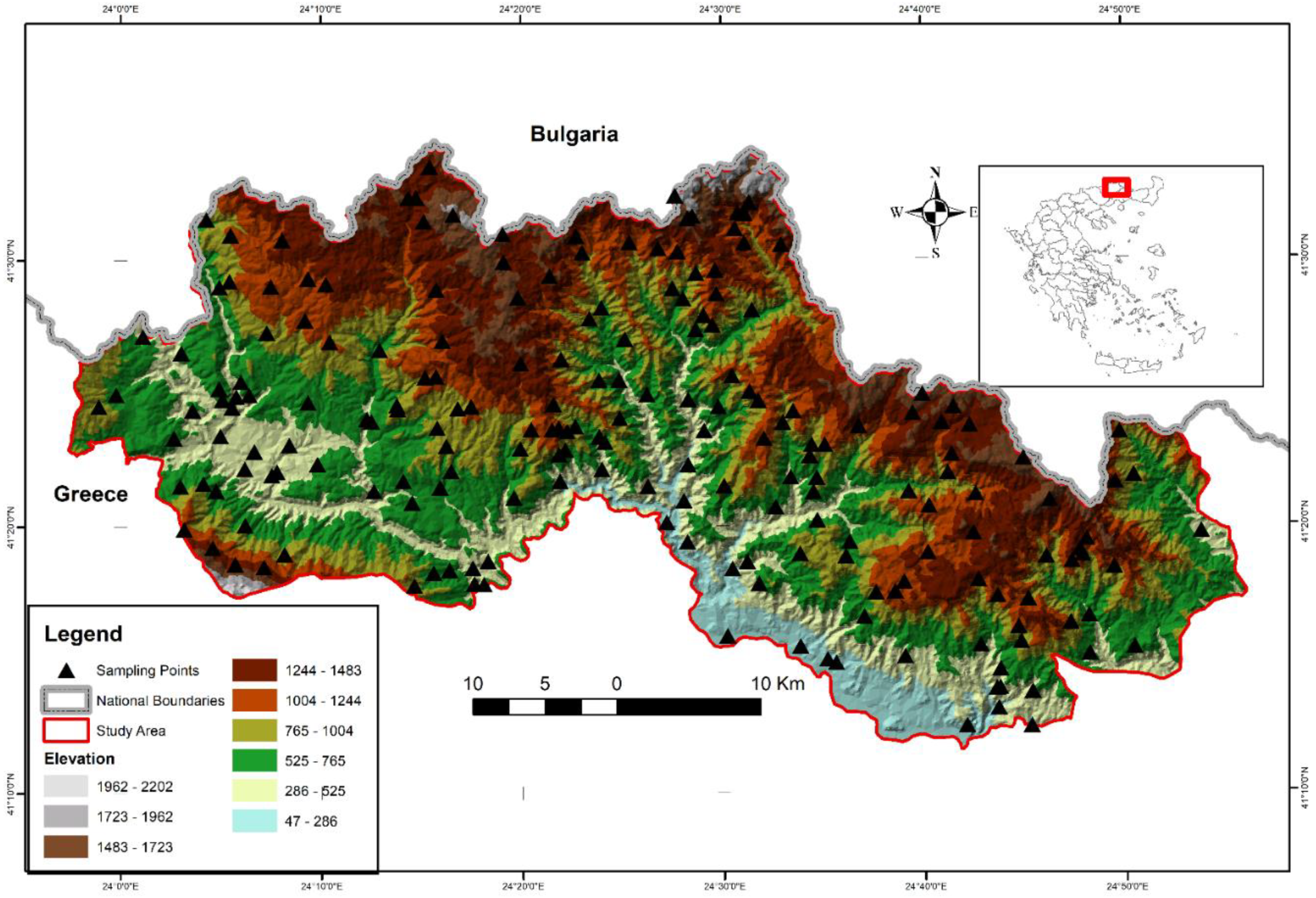
2.1. Study Area
2.2. Remote Sensing Data
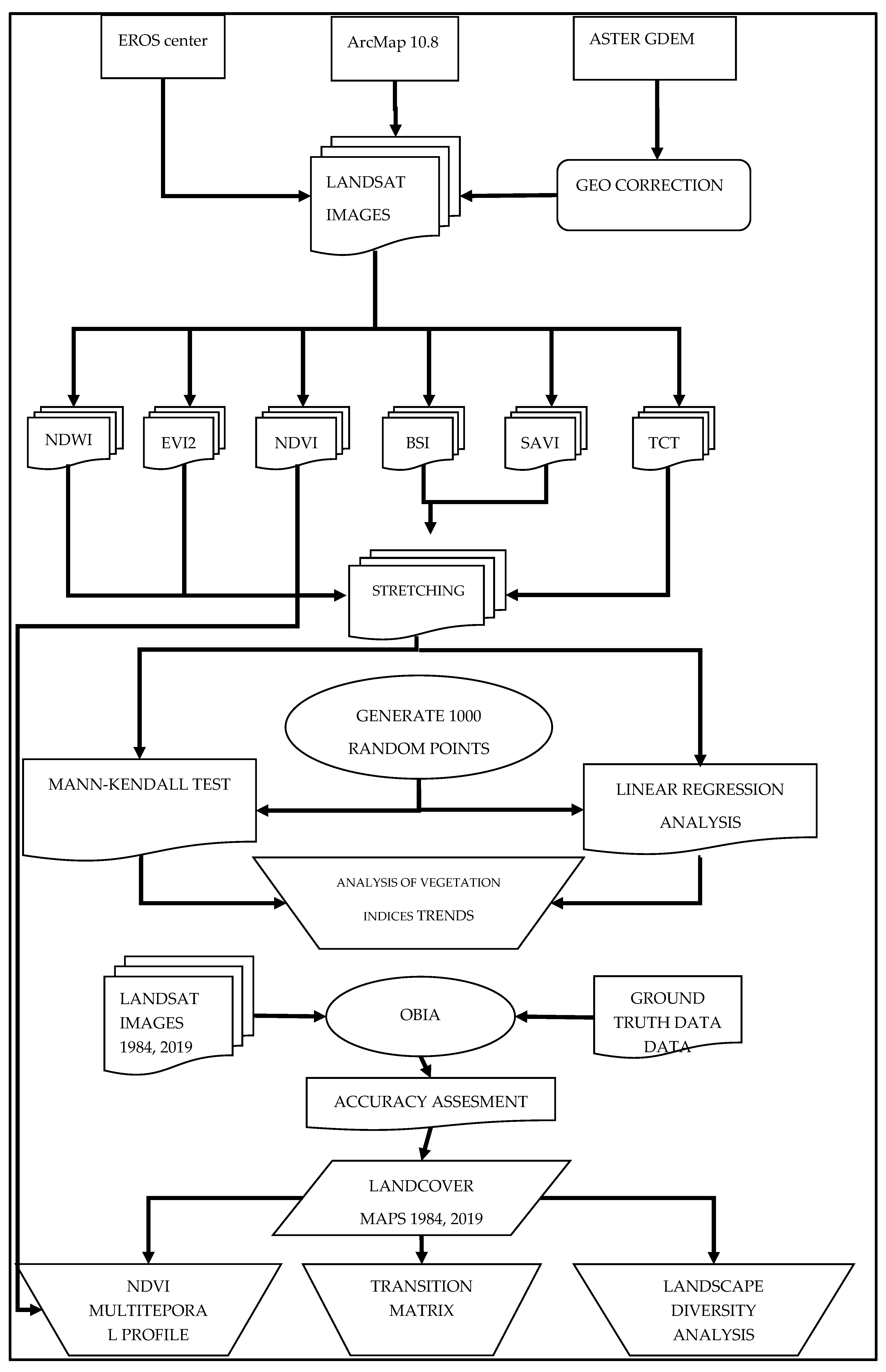
2.3. Remote Sensing Data Analysis
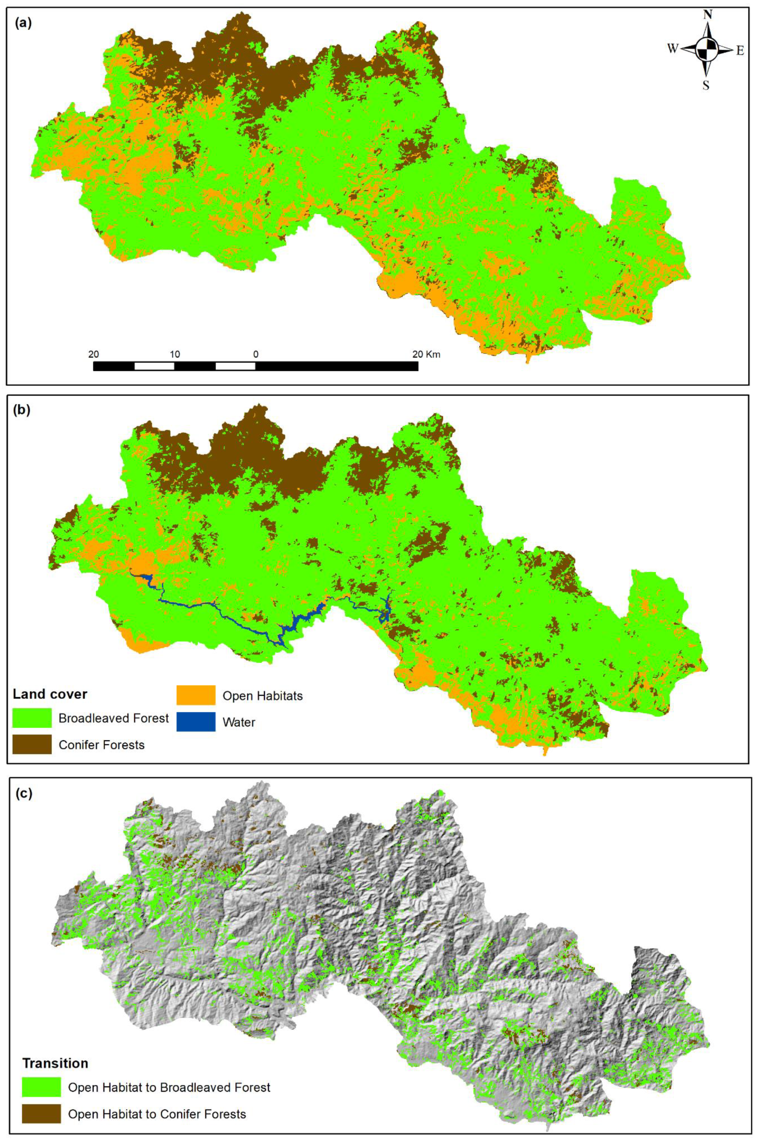
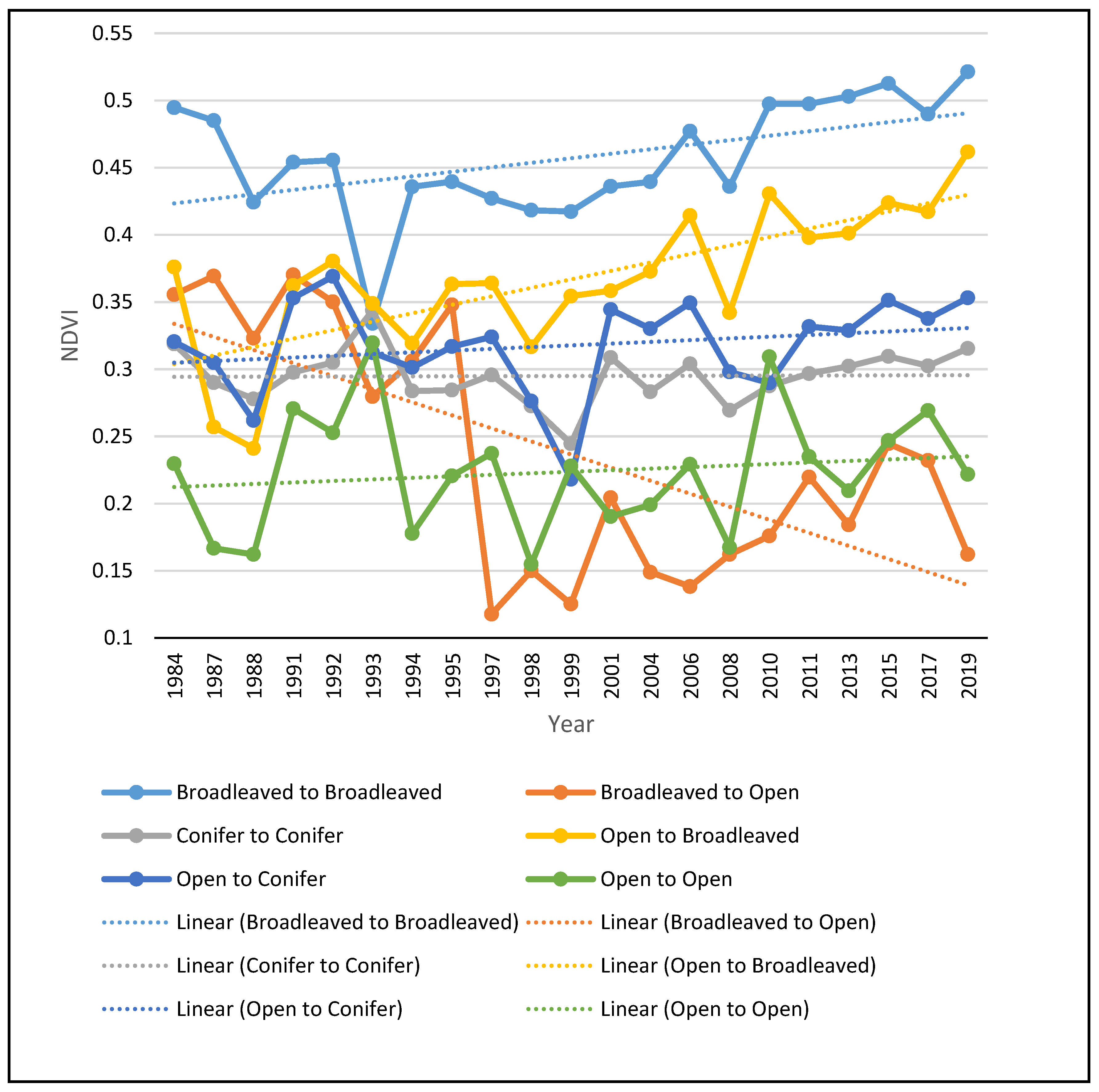
3. Results
4. Discussion
5. Conclusions
Author Contributions
Funding
Conflicts of Interest
References
- Diamond, J. Collapse: How Societies Choose to Fail or Succeed; Penguin Books: New York, NY, USA, 2005; p. 575. [Google Scholar]
- Kulakowski, D.; Seidl, R.; Holeksa, J.; Kuuluvainen, T.; Nagel, T.A.; Panayotov, M.; Svoboda, M.; Thorn, S.; Vacchiano, G.; Whitlock, C.; et al. A walk on the wild side: Disturbance dynamics and the conservation and management of European mountain forest ecosystems. For. Ecol. Manag. 2017, 388, 120–131. [Google Scholar] [CrossRef] [PubMed] [Green Version]
- Mantero, G.; Morresi, D.; Marzano, R.; Motta, R.; Mladenoff, D.J.; Garbarino, M. The influence of land abandonment on forest disturbance regimes: A global review. Landsc. Ecol. 2020, 35, 2723–2744. [Google Scholar] [CrossRef]
- Forest Europe. State of Europe’s Forests 2020; Ministerial Conference on the Protection of Forests in Europe—Forest Europe: Bratislava, Slovakia, 2020.
- Dimopoulos, T.; Kizos, T. Mapping change in the agricultural landscape of Lemnos. Landsc. Urban Plan. 2020, 203, 103894. [Google Scholar] [CrossRef]
- Conedera, M.; Colombaroli, D.; Tinner, W.; Krebs, P.; Whitlock, C. Insights about past forest dynamics as a tool for present and future forest management in Switzerland. For. Ecol. Manag. 2017, 388, 100–112. [Google Scholar] [CrossRef] [Green Version]
- Loran, C.; Ginzler, C.; Burgi, M. Evaluating forest transition based on a multi-scale approach: Forest area dynamics in Switzerland 1850–2000. Reg. Environ. Chang. 2016, 16, 1807–1818. [Google Scholar] [CrossRef]
- San Roman Sanz, A.; Fernandez, C.; Mouillot, F.; Ferrat, L.; Istria, D.; Pasqualini, V. Long-term forest dynamics and land-use abandonment in the Mediterranean mountains, Corsica, France. Ecol. Soc. 2013, 18, 38. [Google Scholar] [CrossRef] [Green Version]
- Hadjigeorgiou, I. Past, present and future of pastoralism in Greece. Pastor. Res. Policy Pract. 2011, 1, 24. [Google Scholar] [CrossRef] [Green Version]
- Gidarakou, I.; Apostolopoulos, C. The productive system of itinerant stockfarming in Greece. Medit 1995, 3, 56–63. [Google Scholar]
- Pérez-Hernández, J.; Gavilán, R.G. Impacts of Land-Use Changes on Vegetation and Ecosystem Functioning: Old-Field Secondary Succession. Plants 2021, 10, 990. [Google Scholar] [CrossRef]
- Labaune, C.; Magnin, F. Pastoral management vs. land abandonment in Mediterranean uplands: Impact on land snail communities. Glob. Ecol. Biogeogr. 2002, 11, 237–245. [Google Scholar] [CrossRef]
- Lasanta, T.; Nadal-Romero, E.; Arnáez, J. Managing abandoned farmland to control the impact of revegetation on the environment. The state of the art in Europe. Environ. Sci. Policy 2015, 52, 99–109. [Google Scholar] [CrossRef] [Green Version]
- Ustaoglu, E.; Collier, M.J. Farmland abandonment in Europe: An overview of drivers, consequences, and assessment of the sustainability implications. Environ. Rev. 2018, 26, 396–416. [Google Scholar] [CrossRef]
- Vacchiano, G.; Garbarino, M.; Lingua, E.; Motta, R. Forest dynamics and disturbance regimes in the Italian Apennines. For. Ecol. Manag. 2017, 388, 57–66. [Google Scholar] [CrossRef] [Green Version]
- Keenleyside, C.; Tucker, G. Farmland Abandonment in the EU: An Assessment of Trends and Prospects; Institute for European Environmental Policy WWF: London, UK, 2010; p. 98. [Google Scholar]
- Haddad, N.M.; Brudvig, L.A.; Clobert, J.; Kendi, D.F.; Gonzalez, A.; Holt, R.D.; Lovejoy, E.T.; Sexton, J.O.; Austin, M.P.; Collins, C.D.; et al. Habitat fragmentation and its lasting impact on Earth’s ecosystems. Sci. Adv. 2015, 1, e1500052. [Google Scholar] [CrossRef] [PubMed] [Green Version]
- Koko, A.F.; Yue, W.; Abubakar, G.A.; Hamed, R.; Alabsi, A.A.N. Monitoring and Predicting Spatio-Temporal Land Use/Land Cover Changes in Zaria City, Nigeria, through an Integrated Cellular Automata and Markov Chain Model (CA-Markov). Sustainability 2020, 12, 452. [Google Scholar] [CrossRef]
- European Environment Agency. Streamlining European Biodiversity Indicators 2020: Building a Future on Lessons Learnt from the SEBI 2010 Process; EEA Technical Report No 11; European Environment Agency: Copenhagen, Denmark, 2012.
- Sohl, T.; Sleeter, B. Role of Remote Sensing for Land-Use and Land-Cover Change Modeling. In Remote Sensing of Lend Use and Land Cover: Principles and Applications; Giri, C., Ed.; CRC Press: Boca Raton, FL, USA, 2012; pp. 225–239. [Google Scholar]
- Bannari, A.; Morin, D.; Bonn, F.; Huete, A.R. A review of vegetation indices. Remote Sens. Rev. 1995, 13, 95–120. [Google Scholar] [CrossRef]
- Banskota, A.; Kayastha, N.; Falkowski, M.J.; Wulder, M.A.; Froese, R.E.; White, J.C. Forest Monitoring Using Landsat Time Series Data: A Review. Can. J. Remote Sens. 2014, 40, 362–384. [Google Scholar] [CrossRef]
- Bright, B.C.; Hudak, A.T.; Kennedy, R.E.; Braaten, J.D.; Khalyani, A.H. Examining post-fire vegetation recovery with Landsat time series analysis in three western North American forest types. Fire Ecol. 2019, 15, 8. [Google Scholar] [CrossRef] [Green Version]
- Kibler, C.L.; Parkinson, A.-M.L.; Peterson, S.H.; Roberts, D.A.; D’Antonio, C.M.; Meerdink, S.K.; Sweeney, S.H. Monitoring Post-Fire Recovery of Chaparral and Conifer Species Using Field Surveys and Landsat Time Series. Remote Sens. 2019, 11, 2963. [Google Scholar] [CrossRef] [Green Version]
- Meneses, B.M. Vegetation Recovery Patterns in Burned Areas Assessed with Landsat 8 OLI Imagery and Environmental Biophysical Data. Fire 2021, 4, 76. [Google Scholar] [CrossRef]
- Morresi, M.; Vitali, A.; Urbinati, C.; Garbarino, M. Forest Spectral Recovery and Regeneration Dynamics in Stand-Replacing Wildfires of Central Apennines Derived from Landsat Time Series. Remote Sens. 2019, 11, 308. [Google Scholar] [CrossRef] [Green Version]
- Vogelmann, J.E.; Gallant, A.L.; Shi, H.; Zhu, Z. Perspectives on monitoring gradual change across the continuity of Landsat sensors using time-series data. Remote Sens. Environ. 2016, 185, 258–270. [Google Scholar] [CrossRef] [Green Version]
- Zhu, Z.; Wulder, M.A.; Roy, D.P.; Woodcock, C.E.; Hansen, M.C.; Radeloff, V.C.; Healey, S.P.; Schaaf, C.; Hostert, P.; Strobl, P.; et al. Benefits of the free and open Landsat data policy. Remote Sens. Environ. 2019, 224, 382–385. [Google Scholar] [CrossRef]
- Poirazidis, K.; Bontzorlos, V.; Xofis, P.; Zakkak, S.; Xirouchakis, S.; Grigoriadou, E.; Kechagioglou, S.; Gasteratos, I.; Alivizatos, H.; Panagiotopoulou, M. Bioclimatic and environmental suitability models for capercaillie (Tetrao urogallus) conservation: Identification of optimal and marginal areas in Rodopi Mountain-Range National Park (Northern Greece). Glob. Ecol. Conserv. 2019, 17, e00526. [Google Scholar] [CrossRef]
- Rhodopi Mountain Range National Park. Available online: http://www.fdor.gr/index.php (accessed on 20 November 2021).
- Crist, E.P.; Cicone, R.C. Application of the Tasseled Cap Concept to simulated thematic mapper data. Photogramm. Eng. Remote Sens. 1984, 50, 343–352. [Google Scholar]
- Polevshchikova, I. Disturbance analyses of forest cover dynamics using remote sensing and GIS. IOP Conf. Ser. Earth Environ. Sci. 2019, 316, 012053. [Google Scholar] [CrossRef]
- Rouse, J.W., Jr.; Haas, R.H.; Schell, J.A.; Deering, D.W.; Harla, J.C. Monitoring the Vernal Advancement 1 and Retrogradation (Greenwave Effect) of Natural Vegetation; Remote Sensing Center: Monterey, CA, USA, 1974. [Google Scholar]
- Huete, A.R. A Soil-Adjusted Vegetation Index (SAVI). Remote Sens. Environ. 1988, 25, 295–309. [Google Scholar] [CrossRef]
- Jiang, Z.; Huete, A.R.; Didan, K.; Miura, T. Development of a two-band enhanced vegetation index without a blue band. Remote Sens. Environ. 2008, 112, 3833–3845. [Google Scholar] [CrossRef]
- Gao, B.C. NDWI—A normalized difference water index for remote sensing of vegetation liquid water from space. Remote Sens. Environ. 1996, 58, 257–266. [Google Scholar] [CrossRef]
- Diek, S.; Fornallaz, F.; Schaepman, M.E.; De Jong, R. Barest Pixel Composite for Agricultural Areas Using Landsat Time Series. Remote Sens. 2017, 9, 1245. [Google Scholar] [CrossRef] [Green Version]
- Viedma, O.; Melia, J.; Segarra, D.; Garcia-Haro, J. Modeling rates of ecosystem recovery after fires by using Landstat TM Data. Remote Sens. Environ. 1997, 61, 383–398. [Google Scholar] [CrossRef]
- Volkova, L.; Adinugroho, W.C.C.; Krisnawati, H.; Imanuddin, R.; Weston, C.J.J. Loss and Recovery of Carbon in Repeatedly Burned Degraded Peatlands of Kalimantan, Indonesia. Fire 2021, 4, 64. [Google Scholar] [CrossRef]
- Storey, E.A.; Stow, D.A.; O’Leary, J.F. Assessing postfire recovery of chamise chaparral using multi-temporal spectral vegetation index trajectories derived from Landsat imagery. Remote Sens. Environ. 2016, 183, 53–64. [Google Scholar] [CrossRef] [Green Version]
- Abram, N.K.; MacMillan, D.C.; Xofis, P.; Ancrenaz, M.; Tzanopoulos, J.; Ong, R.; Goossens, B.; Koh, L.P.; Del Valle, C.; Peter, L.; et al. Identifying Where REDD+ Financially Out-Competes Oil Palm in Floodplain Landscapes Using a Fine-Scale Approach. PLoS ONE 2016, 11, e0156481. [Google Scholar] [CrossRef] [PubMed] [Green Version]
- Ceccato, P.; Flasse, S.; Tarantola, S.; Jacquemond, S.; Gregoire, J.M. Detecting vegetation water content using reflectance in the optical domain. Remote Sens. Environ. 2001, 77, 22–33. [Google Scholar] [CrossRef]
- Rikimaru, A.; Roy, P.S.; Miyatake, S. Tropical forest cover density mapping. Trop. Ecol. 2002, 43, 39–47. [Google Scholar]
- Yue, S.; Wang, C. The Mann-Kendall Test Modified by Effective Sample Size to Detect Trend in Serially Correlated Hydrological Series. Water Resour. Manag. 2004, 18, 201–218. [Google Scholar] [CrossRef]
- Trimple. Ecognition Developer Reference Book; Trimble Documentation: Munich, Germany, 2014. [Google Scholar]
- Xofis, P.; Konstantinidis, P.; Papadopoulos, I.; Tsiourlis, G. Integrating Remote Sensing Methods and Fire Simulation Models to Estimate Fire Hazard in a South-East Mediterranean Protected Area. Fire 2020, 3, 31. [Google Scholar] [CrossRef]
- Xofis, P.; Poirazidis, K. Combining different spatio-temporal resolution images to depict landscape dynamics and guide wildlife management. Biol. Conserv. 2018, 218, 10–17. [Google Scholar] [CrossRef]
- Xofis, P.; Tsiourlis, G.; Konstantinidis, P. A Fire Danger Index for the early detection of areas vulnerable to wildfires in the Eastern Mediterranean region. Euro-Mediterr. J. Environ. Integr. 2020, 5, 32. [Google Scholar] [CrossRef]
- Chavez, P.S.; Kwarteng, A.Y. Extracting spectral contrast in Landsat Thematic Mapper image data using selective principal component analysis. Photogramm. Eng. Remote Sens. 1989, 55, 229–348. [Google Scholar]
- Weiers, S.; Bock, M.; Wissen, M.; Rossner, G. Mapping and indicator approaches for the assessment of habitats at different scales using remote sensing and GIS methods. Landsc. Urban Plan. 2004, 67, 43–65. [Google Scholar] [CrossRef]
- Kleinod, K.; Wissen, M.; Bock, M. Detecting vegetation changes in a wetland area in Northern Germany using earth observation and geodata. J. Nat. Conserv. 2005, 13, 115–125. [Google Scholar] [CrossRef]
- Xofis, P.; Buckley, G.P.; Takos, I.; Mitchley, J. Long term post-fire vegetation dynamics in North-East Medi-terranean ecosystems. The case of Mount Athos Greece. Fire 2021, 4, 92. [Google Scholar] [CrossRef]
- Rempel, R.S.; Kaukinen, D.; Carr, A.P. Patch Analyst and Patch Grid; Ontario Ministry of Natural Resources Centre for Northern Forest Ecosystem Research: Thunder Bay, ON, Canada, 2012.
- Oikonomakis, N.; Ganatsas, P. Land cover changes and forest succession trends in a site of Natura 2000 network (Elatia forest), in northern Greece. For. Ecol. Manag. 2012, 285, 153–163. [Google Scholar] [CrossRef]
- Preiss, E.; Martin, J.-L.; Debussche, M. Rural depopulation and recent landscape changes in a Mediterranean region: Consequences to the breeding avifauna. Landsc. Ecol. 1997, 12, 51–61. [Google Scholar] [CrossRef]
- Queiroz, C.; Beilin, R.; Folke, C.; Lindborg, R. Farmland abandonment: Threat or opportunity for biodiversity conservation? A global review. Front. Ecol. Environ. 2014, 12, 288–296. [Google Scholar] [CrossRef]
- MacDonald, D.; Crabtree, J.R.; Wiesinger, G.; Dax, T.; Stamou, N.; Fleury, P.; Gutierrez Lazpita, J.; Gibon, A. Agricultural abandonment in mountain areas of Europe: Environmental consequences and policy response. J. Environ. Manag. 2000, 59, 47–69. [Google Scholar] [CrossRef]
- Navarro, L.M.; Pereira, H.M. Rewilding abandoned landscapes in Europe. Ecosystems 2012, 15, 900–912. [Google Scholar] [CrossRef] [Green Version]
- Prior, J.; Brady, E. Environmental Aesthetics and Rewilding. Environ. Values 2017, 26, 31–51. [Google Scholar] [CrossRef] [Green Version]
- Giapooliti, S.; Brito, D.; Cerfolli, F.; Franco, F.; Krystufek, B.; Battisti, C. Europe as a model for large carnivores conservation: Is the glass half empty or half full? J. Nat. Conserv. 2018, 41, 73–78. [Google Scholar] [CrossRef]
- Kati, V.; Poirazidis, K.; Dufrene, M.; Halley, J.M.; Korakis, G.; Schindler, S.; Dimopoulos, P. Towards the use of ecological heterogeneity to design reserve networks: A case study from Dadia National Park, Greece. Biodivers. Conserv. 2010, 19, 1585–1597. [Google Scholar] [CrossRef]
- Farina, A. Landscape structure and breeding bird distribution in a sub-Mediterranean agro-ecosystem. Landsc. Ecol. 1997, 12, 362–378. [Google Scholar] [CrossRef]
- Zakkak, S.; Radovic, A.; Nikolov, S.C.; Shumka, S.; Kakalis, L.; Kati, V. Assessing the effect of agricultural land abandonment on bird communities in southern-eastern Europe. J. Environ. Manag. 2015, 164, 171–179. [Google Scholar] [CrossRef] [PubMed]
- Otero, I.; Marull, J.; Tello, E.; Diana, G.L.; Pons, M.; Coll, F.; Martí Boada, M. Land abandonment, landscape, and biodiversity: Questioning the restorative character of the forest transition in the Mediterranean. Ecol. Soc. 2015, 20, 7. [Google Scholar] [CrossRef] [Green Version]
- Moreira, F.; Viedma, O.; Arianoutsou, M.; Curt, T.; Koutsias, N.; Rigolot, E.; Barbati, A.; Corona, P.; Vaz, P.; Xanthopoulos, G.; et al. Landscape and wildfire interactions in southern Europe: Implications for landscape management. J. Environ. Manag. 2011, 92, 2389–2402. [Google Scholar] [CrossRef] [Green Version]
- Dimitrakopoulos, A.P.; Vlahou, M.; Anagnostopoulou, C.G.; Mitsopoulos, I.D. Impact of drought on wildland fires in Greece: Implications of climate change? Clim. Chang. 2011, 109, 331–347. [Google Scholar] [CrossRef]
- Koutsias, N.; Xanthopoulos, G.; Founda, D.; Xystrakis, F.; Nioti, F.; Pleniou, M.; Mallinis, G.; Arianoutsou, M. On the relationships between forest fires and weather conditions in Greece from long-term national observations (1894–2010). Int. J. Wildland Fire 2013, 22, 493–507. [Google Scholar] [CrossRef] [Green Version]
- Pausas, J.G.; Fernandez-Munoz, S. Fire regime changes in the Western Mediterranean Basin: From fuel limited to draught-driven fire regime. Clim. Chang. 2012, 110, 215–226. [Google Scholar] [CrossRef] [Green Version]
- Turco, M.; Bedia, J.; Di Liberto, F.; Fiorucci, P.; von Hardenberg, J.; Koutsias, N.; Llasat, M.C.; Xystrakis, F.; Provenzale, A. Decreasing fires in Mediterranean Europe. PLoS ONE 2016, 11, e0150663. [Google Scholar] [CrossRef] [Green Version]
- Kontoes, C.; Keramitsoglou, I.; Papoutsis, I.; Sifakis, N.I.; Xofis, P. National scale operational mapping of burnt areas as a tool for the better understanding of contemporary wildfire patterns and regimes. Sensors 2013, 13, 11146–11166. [Google Scholar] [CrossRef] [PubMed] [Green Version]


| No | Satellite Image | Acquisition Date | Sun Azimuth | Sun Elevation |
|---|---|---|---|---|
| 1 | LT05 L2SP 183,031 198409052020091802T2 | 1984-09-05 | 138.30231071 | 47.59057823 |
| 2 | LT05 L2SP 183,031 198709142020101402T1 | 1987-09-14 | 140.62014404 | 44.94165515 |
| 3 | LT05 L2SP 183,031 198809162020091702T1 | 1988-09-16 | 142.71327891 | 44.53657612 |
| 4 | LT05 L2SP 183,031 199108242020091502T1 | 1991-08-24 | 131.44570548 | 50.16282795 |
| 5 | LT05 L2SP 183,031 199208102020091402T1 | 1992-08-10 | 126.12509120 | 52.96582165 |
| 6 | LT05 L2SP 183,031 199309142020091302T2 | 1993-09-14 | 139.34338509 | 44.22102328 |
| 7 | LT05 L2SP 183,031 199409012020091302T1 | 1994-09-01 | 132.54159179 | 47.13372063 |
| 8 | LT05 L2SP 183,031 199509042020091202T1 | 1995-09-04 | 129.35709343 | 44.35818789 |
| 9 | LT05 L2SP 183,031 199709092020090902T1 | 1997-09-09 | 140.70768276 | 46.88404403 |
| 10 | LT05 L2SP 183,031 199809122020080902T1 | 1998-09-12 | 143.75951795 | 46.76758454 |
| 11 | LT05 L2SP 183,031 199909152020090702T1 | 1999-09-15 | 144.04727788 | 45.71853946 |
| 12 | LE07L2SP 183,031 200108112020091702T1 | 2001-08-11 | 135.41643415 | 56.50354219 |
| 13 | LT05 L2SP 183,031 200409122020090302T1 | 2004-09-12 | 145.62634405 | 47.15058626 |
| 14 | LT05 L2SP 183,031 200608172020083102T1 | 2006-08-17 | 139.24905979 | 55.70908821 |
| 15 | LT05 L2SP 183,031 200809072020082902T1 | 2008-09-07 | 144.21187687 | 48.76480924 |
| 16 | LT05 L2SP 183,031 201008122020082302T1 | 2010-08-12 | 136.26881870 | 56.50686995 |
| 17 | LT05 L2SP 183,031 201109162020082002T1 | 2011-09-16 | 148.29229264 | 46.56271675 |
| 18 | LC08L2SP 183,031 201309052020091302T1 | 2013-09-05 | 149.43019378 | 51.19080513 |
| 19 | LC08 L2SP 183,031 201508262020090802T1 | 2015-08-26 | 144.89158522 | 54.09527505 |
| 20 | LC08 L2SP 183,031 201708312020090302T1 | 2017-08-31 | 146.99316662 | 52.52530102 |
| 21 | LC08 L2SP 183,031 201908212020082702T1 | 2019-08-21 | 143.22372406 | 55.50553231 |
| Bands (Wavelength μm)-Spatial Resolution | ||
|---|---|---|
| Landsat 5-TM | Landsat 7-ETM | Landsat 8-OLI |
| B1-Coastal/Aerosol (0.435–0.451)-30 m | ||
| B1-Blue (0.45–0.52)-30 m | B1-Blue (0.441–0.514)-30 m | B2-Blue (0.452–0.512)-30 m |
| B2-Green (0.52–0.60)-30 m | B2-Green (0.519–0.601)-30 m | B3-Green (0.533–0.590)-30 m |
| B3-Red (0.63–0.69)-30 m | B3-Red (0.631–0.692)-30 m | B4-Red (0.636–0.673)-30 m |
| B4-NIR (0.76–0.90)-30 m | B4-NIR (0.772–0.898)-30 m | B5-NIR (0.851–0.879)-30 m |
| B5-SWIR 1 (1.55–1.75)-30 m | B5-SWIR 1 (1.547–1.749)-30 m | B6-SWIR 1 (1.566–1.651)-30 m |
| B7-SWIR 2 (2.08–2.35)-30 m | B7-SWIR 2 (2.064–2.345)-30 m | B7-SWIR 2 (2.107–2.294)-30 m |
| B6-TIR (10.40–12.50)-120 m | B6-TIR (10.31–12.36)-60 m | B10-TIR 1 (10.60–11.19)-30 m |
| B11-TIR 2 (11.50–12.51)-30 m | ||
| B9-Cirrus (1.363–1.384)-30 m | ||
| B8-Pan (0.515–0.896)-15 m | B8-Pan (0.503–0.676)-15 m | |
| Vegetation Index | Formula | Reference |
|---|---|---|
| NDVI | ((NIR − RED))/((NIR + RED)) | [33] |
| SAVI | ((NIR − RED))/((NIR + RED + 0.5)) × (1 + 0.5) | [34] |
| EVI2 | 2.5 × ((NIR − RED))/((NIR+2.4 × RED + 1)) | [35] |
| NDWI | ((NIR − SWIR))/((NIR + SWIR)) | [36] |
| BSI | ((SWIR2 + RED)-(NIR + BLUE))/((SWIR2 + RED) + (NIR + BLUE)) | [37] |
| TCT Index | Linear Regression | Mann Kendal | |||
|---|---|---|---|---|---|
| b | Adj-R2 | p | Z | p | |
| Brightness | −8.58 | - | 0.377 | −0.513 | 0.608 |
| Greenness | 46.2 | 0.37 | 0.002 | 2.567 | 0.012 |
| Wetness | 11.4 | 0.14 | 0.053 | 1.782 | 0.085 |
| Vegetation Indices | Linear Regression | Mann Kendal | |||
|---|---|---|---|---|---|
| b | Adj-R2 | p | Z | p | |
| NDVI | 0.002 | 0.49 | <0.001 | 2.989 | 0.003 |
| SAVI | 0.003 | 0.48 | <0.001 | 2.876 | 0.004 |
| EVI2 | 0.004 | 0.48 | <0.001 | 2.876 | 0.004 |
| NDWI | 0.001 | 0.45 | <0.001 | 3.045 | 0.002 |
| BSI | −0.001 | 0.49 | <0.001 | −3.045 | 0.002 |
| 2019 | |||||||
|---|---|---|---|---|---|---|---|
| Open Habitats | Broadleaved Forest | Conifer Forests | Water | Sum | Percent Cover (%) | ||
| 1984 | Open Habitats | 13,734.2 | 20,550.5 | 3372.1 | 465.0 | 38,121.8 | 21.6 |
| Percent (%) | 36.0 | 53.9 | 8.8 | 1.2 | |||
| Broadleaved forests | 2403.8 | 102,797.4 | 7148.3 | 807.8 | 113,157.3 | 64.19 | |
| Percent (%) | 2.0 | 87.2 | 6.1 | 0.7 | |||
| Conifer forests | 176.0 | 5192.8 | 19,560.2 | 54.9 | 24,983.9 | 14.17 | |
| Percent (%) | 0.7 | 21.5 | 80.8 | 0.2 | |||
| Sum | 16,314.0 | 128,540.6 | 30,080.5 | 1327.8 | 176,262.9 | ||
| Percent Cover (%) | 9.3 | 72.9 | 17.1 | 0.8 | |||
Publisher’s Note: MDPI stays neutral with regard to jurisdictional claims in published maps and institutional affiliations. |
© 2022 by the authors. Licensee MDPI, Basel, Switzerland. This article is an open access article distributed under the terms and conditions of the Creative Commons Attribution (CC BY) license (https://creativecommons.org/licenses/by/4.0/).
Share and Cite
Xofis, P.; Spiliotis, J.A.; Chatzigiovanakis, S.; Chrysomalidou, A.S. Long-Term Monitoring of Vegetation Dynamics in the Rhodopi Mountain Range National Park-Greece. Forests 2022, 13, 377. https://doi.org/10.3390/f13030377
Xofis P, Spiliotis JA, Chatzigiovanakis S, Chrysomalidou AS. Long-Term Monitoring of Vegetation Dynamics in the Rhodopi Mountain Range National Park-Greece. Forests. 2022; 13(3):377. https://doi.org/10.3390/f13030377
Chicago/Turabian StyleXofis, Panteleimon, John A. Spiliotis, Stavros Chatzigiovanakis, and Anastasia S. Chrysomalidou. 2022. "Long-Term Monitoring of Vegetation Dynamics in the Rhodopi Mountain Range National Park-Greece" Forests 13, no. 3: 377. https://doi.org/10.3390/f13030377
APA StyleXofis, P., Spiliotis, J. A., Chatzigiovanakis, S., & Chrysomalidou, A. S. (2022). Long-Term Monitoring of Vegetation Dynamics in the Rhodopi Mountain Range National Park-Greece. Forests, 13(3), 377. https://doi.org/10.3390/f13030377


