Article

The Effect of Robinia pseudoacacia Plantation on Soil Desiccation across Different Precipitation Zones of the Loess Plateau, China

1
Institute of Geographical Science, Taiyuan Normal University, Jinzhong 030619, China
2
State Key Laboratory of Urban and Regional Ecology, Research Center for Eco-Environmental Sciences, Chinese Academy of Sciences, Beijing 100085, China
3
University of Chinese Academy of Sciences, Beijing 100049, China
4
Department of Biology, Taiyuan Normal University, Jinzhong 030619, China
*
Author to whom correspondence should be addressed.
Forests 2022, 13(2), 321; https://doi.org/10.3390/f13020321
Submission received: 5 January 2022 / Revised: 1 February 2022 / Accepted: 12 February 2022 / Published: 16 February 2022
(This article belongs to the Section Forest Hydrology)

Abstract

:
Ecological restoration has increased vegetation cover and reduced soil erosion, but it has also resulted in decreased soil-moisture content (SMC) and increased soil desiccation, which has ultimately led to a weakening of the “soil reservoir” function and a decline in the growth of plantations. Thus, soil desiccation has been a serious threat to the sustainable utilization of soil water resources and vegetation rehabilitation. In this study, the soil moisture of a Robinia pseudoacacia forest as well as its corresponding soil desiccation to a depth of 500 cm were measured across three different precipitation zones (400–450, 500–550 and 550–600 mm) along a north–south transect on the Loess Plateau. The results showed that the soil-moisture environment and soil desiccation status generally improved with the increasing precipitation gradient, while soil-moisture over-consumption significantly declined (p < 0.05). However, due to the elder forest-stand age and severe growth recession, the soil desiccation of R. pseudoacacia in the northern part was less than that in central zones. As the forest-stand age increased, SMC of R. pseudoacacia increased firstly and then decreased, and both soil-moisture consumption and the average soil desiccation rate peaked in the RP-5a, showing no significant consistence with forest-stand age. Therefore, understanding the soil-moisture status of forestland may better provide scientific basis for native vegetation restoration and reconstruction in water-limited regions.

1. Introduction

Soil desiccation on the Loess Plateau is a unique phenomenon of soil hydrological deficit, which is formed by the joint action of various biotic and abiotic factors, such as vegetation, arid climate and aeolian soil. It is caused by an imbalance of the relationships between natural precipitation, soil-moisture storage and vegetation moisture consumption. Ultimately, soil desiccation may result in the significant reduction of deep-soil-moisture storage, as well as the formation of desiccated-soil layers located beneath the rainfall-infiltration layer, with lower soil-moisture content and relative persistence [1,2,3]. In addition, soil desiccation may bring about a series of ecological problems, such as a weakened “soil-reservoir” function, soil degradation, truncation between surface water and groundwater, deepened desiccated-soil layers as well as vegetation recession and death, and local climate drought [4,5]. Soil desiccation is widely reported at home and abroad, including in Russia [6], eastern Amazonia [7], southern Australia [8], the southwestern United States [9] and the Chinese Loess Plateau [5]. Since it was found in the southern edge of the Loess Plateau in 1960s, soil desiccation has gradually expanded to the whole plateau, and has increased desiccated-soil layers along with lowering the soil-moisture content. Due to its adverse effect on soil hydrology, soil desiccation has become one of the serious obstacles to ecological restoration and reconstruction on the water-limited Loess Plateau [4].
On account of the increase in serious damages to the eco-environment of the Loess Plateau, soil desiccation has been noticed by more and more scholars and researchers [5,10,11,12,13]. The evaluation criteria, types, characteristics, causes and negative effects as well as other aspects of soil desiccation on the Loess Plateau were investigated in detail by Shangguan [10] and Chen [14]. They suggested that soil desiccation could be alleviated by selecting the right plantation with reasonable density as well as implementing natural recovery with shrub and grass rotation and other catchment measures. Wang [1,2,15] carried out a detailed evaluation of soil desiccation and its controlling factors in various land-use types and climate zones on the Loess Plateau and showed that the spatial distribution of desiccated-soil layers was mainly determined by soil texture and precipitation along the northwest–southeast direction. Besides, he also proposed that desiccated-soil layers could be eased and gradually restored by the succession of natural vegetation [15]. However, research on soil desiccation on the Loess Plateau is still in the early phenomenon-revealing stage, which is mainly focused on the definition, regional spatial- and temporal-distribution types, causes, and damage as well as the influencing factors and mitigating measures of desiccated-soil layers. Meanwhile, most of the research area is limited to a small watershed, and there are no unified grading standards for evaluating soil desiccation from the perspective of a quantitative analysis [16,17]. Some researchers have proposed their respective criteria and quantitative indicators for evaluating soil desiccation, but these indicators are regional and of great randomness, and cannot be fully applied to the vast Loess Plateau region [18,19,20]. Currently, Li [21,22] has established a soil-desiccation index (SDI) with soil-moisture content (SMC), stable soil moisture (SSM) and the wilting soil moisture (WM) and has widely applied it to deep-soil desiccation under various vegetation and land-use types at different precipitation zones on the Loess Plateau. Thus, the SDI can be used as the unified evaluation criteria of soil desiccation in the Loess Plateau region.
Owing to its strong adaptability and resistance to a drought-prone environment, Robinia pseudoacacia (R. pseudoacacia hereafter) is widely planted as one of the main reforestation species in the semi-arid and semi-humid areas of the Loess Plateau [23,24]. Moreover, due to its special physiological characteristics of both moist-fertile-soil likeness and water resistance, R. pseudoacacia is the only species that is widely distributed in the north and south of the Loess Plateau. However, its developed lateral roots can fully absorb the deep-soil moisture [23,25,26,27,28], which, when coupled with long-term water scarcity, results in severe soil desiccation such as soil-moisture deficit, desiccated-soil layers and the wide appearance of “small and old trees” with low productivity [29,30,31]. In recent years, domestic scholars have conducted a few studies on the soil desiccation of R. pseudoacacia on the plateau. Wang reached the conclusion that widespread severe desiccated-soil layers had formed in R. pseudoacacia of the Yan’an experimental area on the basis of measured soil-moisture and vegetation conditions, and that desiccated-soil layers are more significantly affected by sunny and steep slopes than forest-stand age [32]. Likewise, Wang also educed that the soil-moisture deficit was strongly in accord with the growth of R. pseudoacacia [25]. The soil-moisture deficit resulted in desiccated-soil layers with decreasing precipitation, which seriously affect growth and further lead to a widespread inefficient and low-yield forest. It was concluded that the soil-moisture deficit accumulated year after year and formed permanent desiccated-soil layers in 28a R. pseudoacacia based on the measured soil-moisture content of artificial vegetation on the steep slope of the Loess region. In general, the rainfall-infiltration depth was merely about 1.2 m and the soil desiccation in R. pseudoacacia was more severe than other tree species with the similar forest-stand ages [5,33]. The soil-desiccation phenomenon has been widely described at the plot scale. However, due to the large span of the Loess Plateau along the north–south direction, there is also a knowledge gap in understanding the overall soil-moisture and soil-desiccation conditions with regards to the specific tree species, such as R. pseudoacacia plantations in different precipitation zones. This is not only a practical requirement for soil-desiccation research, but also for the sustainable management of regional afforestation activities. Therefore, in this study, the deep-soil moisture of R. pseudoacacia with the comparison of natural grassland at different precipitation zones along north–south direction on the Loess Plateau was measured and analyzed, and its soil-desiccation intensity and desiccated-soil-layer thickness were also quantitatively evaluated with the increase in forest-stand age. Likewise, the required time for the restoration of a desiccated-soil layer to a stable soil-moisture content was measured, and deep-soil-desiccation characteristics and its mitigation measures were explored as well, so as to provide a scientific basis for vegetation restoration and reconstruction on the Loess Plateau.

2. Materials and Methods

2.1. Description of the Study Sites

This study was conducted in the central and northern areas (109.12°–111.26° E, 35.34°–39.22° N) of the Chinese Loess Plateau. The soil-moisture content of different-aged Robinia pseudoacacia plantations in different precipitation zones along the north–south transect was measured between May–July 2015. On the basis of climate and natural-vegetation differences, 8 sampling sites (named as Hequ, Liudaogou catchment of Shenmu County, Jiuyuangou catchment of Suide County, and Zhifanggou catchment of Ansai County in the typical northern, temperate, semi-arid, drought-prone steppe zone, Angou catchment of Yanchang County and Yangjuangou catchment of Yanan County in the central, warm-temperate, semi-arid steppe zone, and Renjiatai of Fuxian County as well as Zhaojiayuan of Yijun County in the southern, warm-temperate, semi-humid forest-steppe zone) were selected for the soil-desiccation experiment. The distribution of specific soil-moisture-sampling sites was shown in Figure 1.
In the typical northern, temperate, semi-arid, drought-prone steppe zone, the average annual air temperature was between 6.1 °C and 7.3 °C, the effective accumulated temperature above 10 °C was 2000–3200 °C, and the annual precipitation and potential evapotranspiration ranged from 400 to 500 mm and 1700 to 2500 mm, respectively. Additionally, the zonal soil consisted of sandy Aridisols with light to sandy loam according to the USDA classification system. In the central, warm-temperate, semi-arid steppe zone, the average annual air temperature ranged from 9.5 °C to 10.6 °C and the effective accumulated temperature above 10 °C was between 2000 °C and 3000 °C, with the average annual precipitation and potential evapotranspiration between 500 and 550 mm and 1600 and 2100 mm, respectively. Additionally, the zonal soil transitioned from Aridisols to Alfisols with light loam to medium loam. In the southern, warm-temperate, semi-humid forest-steppe zone, the average annual air temperature and effective accumulated temperature above 10 °C were 9.0–9.2 °C and 3000–3500 °C, respectively. The average annual precipitation ranged from 550 to 600 mm and the mean annual potential evapotranspiration was between 1400 and 1900 mm [21,22,34]. Moreover, the zonal soil was clayed Alfisols with medium loam. Detailed background information regarding all of the sampling sites was summarized in Table 1.

2.2. Field Sampling Measurements

In the northern and central regions of the Loess Plateau, a paired experiment design with R. pseudoacacia sampling sites and adjacent natural grassland was selected along north–south direction [23]. In consideration of moisture-consumption depth, soil samples were collected at a depth of 500 cm in R. pseudoacacia and 300 cm in the natural grassland, respectively, with soil drilling (5 cm diameter) at an interval of 20 cm. At each sampling site, soil samples were collected with three duplicates from the same depth. To avoid the loss of soil moisture, soil samples were kept in sealed aluminum boxes in the field and then weighted in time. Simultaneously, sample sites were marked with GPS receivers, and plant species as well as geomorphologic characteristics such as altitude, slope gradient, slope aspect, slope position and other relevant information were also recorded. In addition, soil profiles with depths of 40 cm were excavated at each sampling site, and undisturbed soil was obtained using a cutting ring at the depths of 20 cm and 40 cm so as to determine the bulk-soil density and other physical parameters.

2.3. Soil-Desiccation Evaluation and Statistical Methods

Soil-moisture content (SMC) was measured by the oven-drying method at 105 °C for 24 h to obtain a constant mass. Gravimetric SMC was calculated by the soil-moisture loss from wet soil to drought soil during oven drying.
SMC (%) was calculated as follows:
SMC = G 1 G 2 G 2 G 100 %
where SMC is the gravimetric soil-moisture content (%), G is the weight of the empty aluminum box (g), G1 is the weight of the empty aluminum box and the wet soil before oven drying (g), and G2 is the weight of the aluminum box with dried soil after oven drying (g).
Soil-moisture storage (SMS) (mm) was calculated as follows:
SMS = i = 1 n BD SMC i H i 0.1
where SMS is the soil-moisture storage among all the soil profiles (mm), BD is the bulk-soil density (g/cm3), SMCi is the gravimetric soil-moisture content at the ith depth of the soil profiles (%), and Hi is the soil depth of the ith soil layer (mm).
Available soil-moisture storage (ASMS) was represented as the difference between soil-moisture storage and that at the wilting soil moisture and was calculated as follows:
ASMS = SMS − SMSWM
where ASMS is the available soil-moisture storage among all the soil profiles (mm), SMSWM is the soil-moisture storage among all the soil profiles at the wilting soil moisture (mm).
Relative soil moisture (RSM) was used to evaluate the availability of soil moisture to the plant and was calculated as follows:
RSM = SMC FC
where RSM is the relative soil moisture (%) and FC is the soil field capacity of each sampling site (%).
Soil-desiccation index was calculated as follows:
SDI = SMC WM SSM WM 100 %
where SDI is the soil-desiccation index (%), WM is the wilting soil moisture (%), and SSM is the stable soil moisture of the soil-profile layers (%). Simultaneously, it was determined that a smaller SDI value represents a stronger intensity of soil desiccation and a greater SDI value represents a lower soil-desiccation intensity. On the basis of the above-calculated SDI, soil-desiccation intensity on the Loess Plateau was divided into six grades (Table 2).
In general, stable soil moisture was regarded as the upper limit in evaluating soil desiccation under different vegetation types [21,22]. In the semi-humid and semi-arid areas of the Loess Plateau, on account of the constant variation in soil-moisture content along with annual and seasonal precipitation, as well as the difficulty in directly determining the stable deep-soil moisture in the short term, the SSM (stable soil moisture), which is the arithmetic mean value of wilting soil moisture and soil field capacity, was used to evaluate soil desiccation. Additionally, the SSM was about 50% to 70% of the soil-field capacity [21,22,35].

3. Results

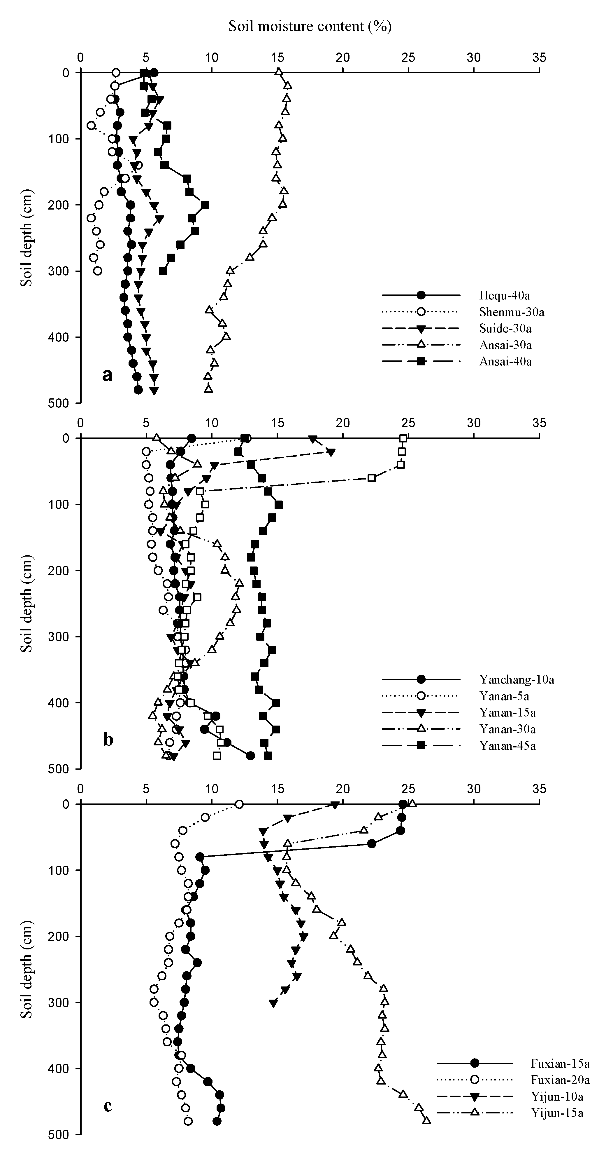
3.1. Soil-Moisture Content of R. pseudoacacia at Different Precipitation Zones

In the typical northern, temperate, semi-arid, drought-prone steppe zone (Figure 2a), the average SMC was between 1.97% and 13.14%, and the SMS varied from 84.42 to 834.26 mm (Table 3). Apart from the RP-30a of the Zhifanggou catchment, the SMC and SMS were significantly lower than that in the natural grassland, suggesting that at the same forest-stand age or in similar environmental conditions, the soil moisture of R. pseudoacacia in Ansai under good precipitation conditions was much higher than that in the other sampling sites. In addition to the RP-30a of Ansai County, the SMC in each sampling site was significantly lower than the stable soil moisture (11.35%). According to the stable soil moisture, all of the sampling sites exhibited varying degrees of soil desiccation except for the Zhifanggou catchment. By comparing the five sampling sites (Table 3), the ASMS was −138.85, −172.86, 62.25, 561.21 and 92.99 mm in turn from north to south, which was highly consistent with the aforementioned results. However, soil desiccation in the Hequ and Shenmu sites were the most severe with an average annual soil-desiccation rate of 11.58 mm per year and 11.48 mm per year, respectively.
In the central, warm-temperate, semi-arid steppe zone (Figure 2b), the average SMC and SMS of each sampling site varied from 6.07% to 13.80%, and 435.50 mm to 897.26 mm, respectively (Table 3), where the SMC was the lowest for the RP-5a and highest for the RP-45a in the Yangjuangou catchment of Yan’an, but both of them were obviously lower than the corresponding natural grassland (15.44%). Apart from the RP-45a, the SMC of the remainder of the different-aged R. pseudoacacia in the Yangjuangou catchment were significantly lower than the stable soil moisture (13.25%) and exhibited diverse degrees of soil desiccation. However, the soil moisture of the RP-10a in the Angou catchment of Yanchang reached the second-lowest level with a mean SMC of 8.01% and an SMS of 520.65 mm, which were lower than the corresponding stable soil moisture (12.43%) but higher than the natural-grassland control (7.11%), and they also exhibited the phenomenon of soil desiccation. In addition, the ASMS of each sampling site ranged from 140.40 mm to 604.76 mm, and in which the RP-10a in Yanchang was the lowest, while the RP-45a in the Yan’an experimental area reached the highest. In view of the high soil-moisture over-consumption and the average annual soil-desiccation rate of R. pseudoacacia forests, the results further demonstrated the above conclusion that each sampling site exhibited different levels of soil desiccation, except for the RP-45a in Yangjuangou catchment which was of the optimal soil-moisture conditions.
In the southern, warm-temperate, semi-humid forest-steppe zone (Figure 2c), the average SMC ranged from 7.49% to 21.03%, and the SMS varied from 486.72 mm to 1384.24 mm (Table 3). The SMCs of the RP-15a and RP-20a at Renjiatai were lower than the stable soil moisture (13.09%) and the natural-grassland control (19.19%), leading to different degrees of soil desiccation. Meanwhile, their corresponding ASMS and soil-moisture over-consumption were 450.06 mm, 215.02 mm and 129.09 mm, 364.13 mm, respectively, and their average annual soil-desiccation rate reached 8.61 mm and 18.21 mm per year, which together indicated that soil-desiccation rate and soil-desiccation intensity gradually strengthened as the forest-stand age increased. However, the soil-moisture conditions of the RP-10a and RP-15a at Zhaojiayuan were much better than that in Fuxian, and there was no soil desiccation or soil-moisture over-consumption, indicating a relatively high soil-moisture-conservation effect.
Generally, through comparing the soil-moisture conditions of each R. pseudoacacia sampling site across the three different precipitation zones, it could be concluded that the SMC, SMS and ASMS of each R. pseudoacacia sampling site showed increasing tendency, while the soil-moisture over-consumption significantly decreased as precipitation increased along the north–south direction. R. pseudoacacia plantations in the northern and central zones were found to have various degrees of soil desiccation, and the mean annual soil-desiccation rate in the typical northern, temperate, semi-arid, drought-prone steppe zone was much smaller than that in the central, warm-temperate, semi-arid steppe zone.
In total, by comparing the soil-moisture conditions of different-aged R. pseudoacacia at the three different precipitation zones (Table 4), the results indicated that on account of the high degree of precipitation replenishment and low vegetation density in the RP-15a and the RP-45a, respectively, the SMC and ASMS in southern zone were much higher, whereas the SMC in the remainder of the sampling sites increased first and then decreased with the increase in forest-stand age. Soil-moisture over-consumption and the average annual soil-desiccation rate showed no apparent variation rules with forest-stand age, but both of them reached their highest level in the RP-5a.

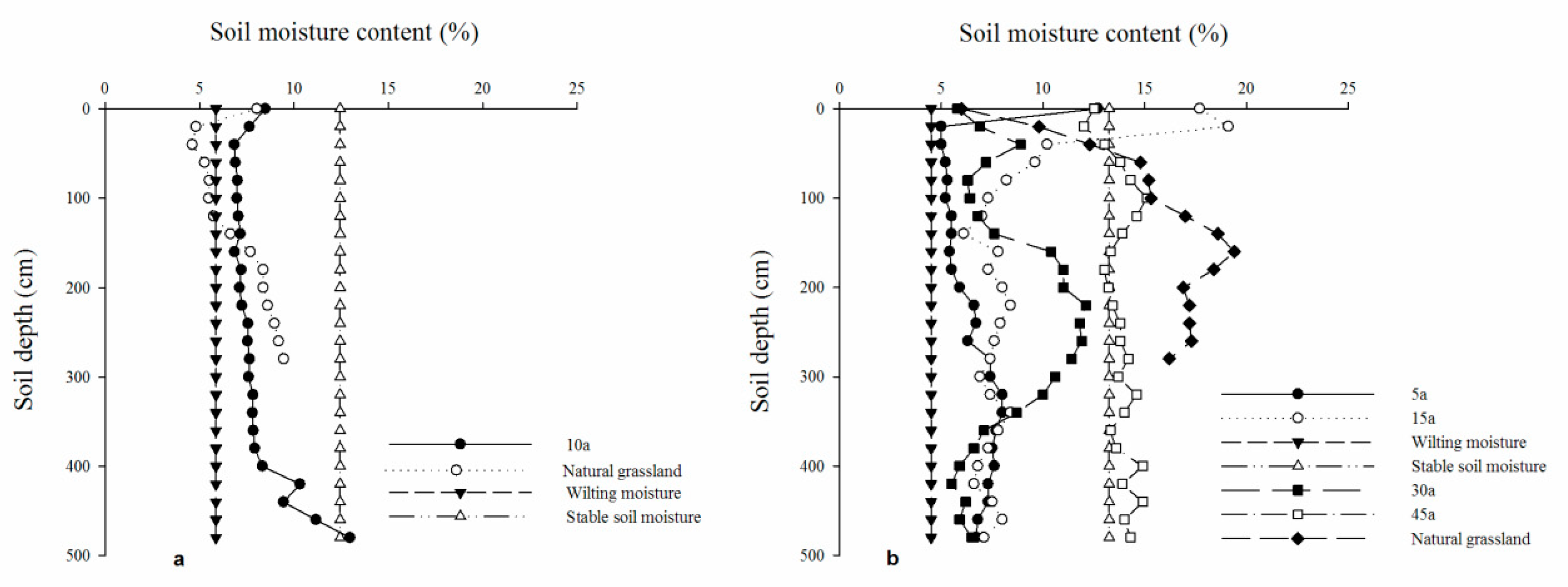
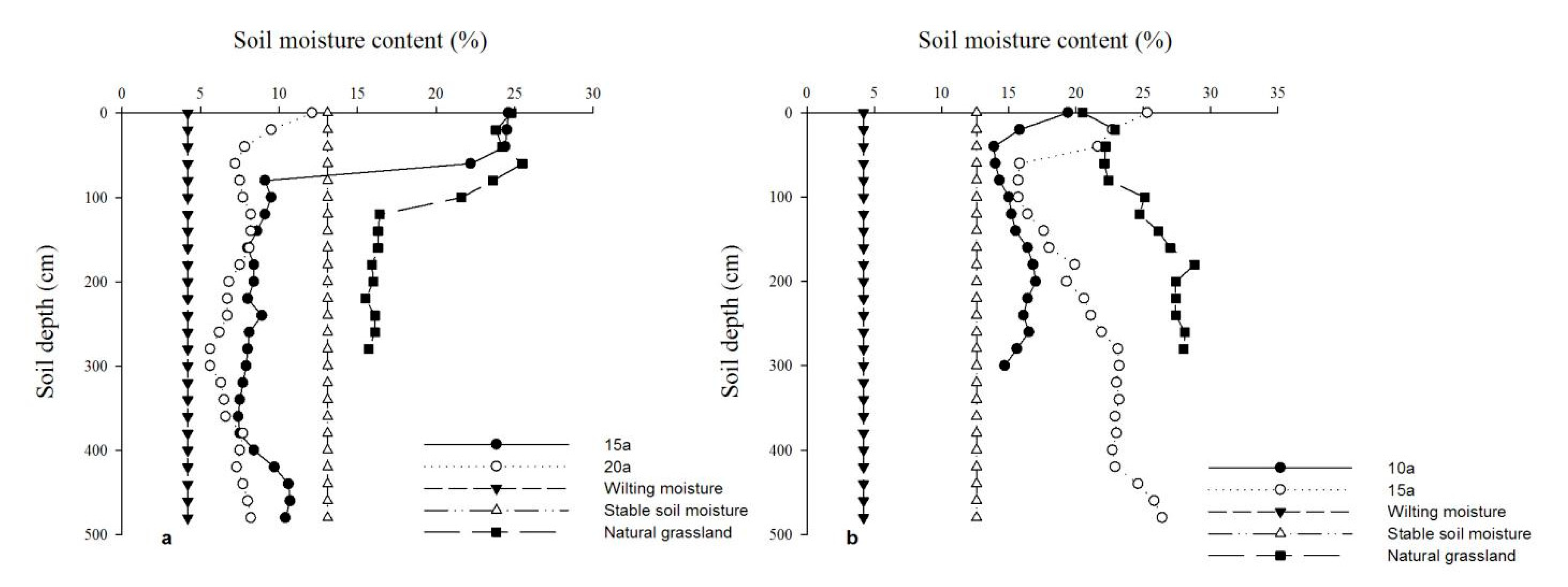
3.2. Soil-Moisture Availability of R. pseudoacacia

The soil-moisture availability synthetically reflects the soil-moisture supply to the plant as well as the ease or complexity of soil-moisture utilization by plant. In this study, the relative soil moisture (RSM), which is the ratio of SMC to field capacity (FC), was used to evaluate the availability of soil moisture to vegetation growth according to the soil-moisture-availability classification results within different soil-texture zones by Yang on the Loess Plateau [36]. In view of the effects of different soil textures along the north–south direction on soil-moisture physical properties, the RSM range corresponding to each soil-moisture-availability grade varied slightly, of which the gravitational-infiltration aquifer and high-efficiency aquifer within different soil textures were consistent with each RSM range of greater than 100% and between 80% and 100%, respectively. The RSM range of the high-efficiency aquifer varied from 60% to 80% in sandy loam and medium loam, and from 50% to 80% in light loam, while the RSM range of mid-efficiency aquifer separately ranged from 25% to 59% in sandy loam, 30% to 49% in light loam and 35% to 59% in medium loam. Ultimately, the rest of the RSM ranges lower than the mid-efficiency aquifer were the invalid/low-efficiency aquifers.
As shown in Table 5, the SMC of R. pseudoacacia plantations generally increased as precipitation increased along the north–south direction. The proportion of invalid/low-efficiency aquifers and mid-efficiency aquifers accounting for the total soil profile gradually declined, while the proportion of high-efficiency aquifers and very-high-efficiency aquifers as well as their corresponding RSMs slowly increased. Even in the southern, warm-temperate, semi-humid forest-steppe zone, on account of the abundant rainfall replenishment, there appeared to be a relatively high proportion of gravitational-infiltration aquifers in the RP-15a forests of the Renjiatai and Zhaojiayuan sampling sites.
In the typical northern, temperate, semi-arid, drought-prone steppe zone, the very-high-efficiency aquifer only appeared in the RP-30a of the Ansai sampling site with a proportion of 44%. The proportion of mid-efficiency aquifers and low-efficiency/invalid aquifers to the total profile in Hequ, Shenmu and Suide experimental areas were 16%, 6.25%, 60% and 84%, 93.75%, 40%, respectively, and the corresponding average RSMs were 28.59%, 31.43%, 34.09% and 20.57%, 14.06%, 27.91%, respectively. While, in the Ansai sampling sites, the high-efficiency aquifer in the RP-30a accounted for 56% of the total soil profile with an average RSM of 62.13%, and the high-efficiency aquifers, mid-efficiency aquifers and low-efficiency/invalid aquifers in the RP-40a separately accounted for 6.25%, 68.75% and 25% with the corresponding average RSMs of 51.63%, 39.43% and 35.24%, respectively.
In the central, warm-temperate, semi-arid steppe zone, apart from the RP-15a of the Yangjuangou catchment, there were no very-high-efficiency aquifers in the sampling sites. High-efficiency aquifers and mid-efficiency aquifers separately accounted for 4% and 96% with each homologous average RSM of 68.18% and 41.07% in the Angou catchment. The average RSM of the high-efficiency aquifers, mid-efficiency aquifers and low-efficiency/invalid aquifers in the RP-5a and RP-30a of the Yangjuangou catchment were 57.73%, 33.48%, 25.15% and 52.42%, 37.52%, 27.56%, and each aquifer accounted for 4%, 48%, 48% and 24%, 44%, 32% of the total soil profile, respectively. There were no high-efficiency aquifers in the RP-15a of the Yangjuangou sampling site, while the very-high-efficiency aquifers, mid-efficiency aquifers and low-efficiency/invalid aquifers separately accounted for 8%, 88%, 4%, with respective average RSMs of 83.64%, 35.23%, 27.73%. While in the RP-45a, there were only high-efficiency aquifer with an average RSM of 62.75%, further indicating a better soil-moisture condition than the other sites.
In southern, warm-temperate, semi-humid forest-steppe zone, neither the very-high-efficiency aquifer nor high-efficiency aquifer were present in the RP-15a of the Fuxian experimental sites, and mid-efficiency aquifers and low-efficiency/invalid aquifers separately accounted for 72% and 12%, with each average RSM of 40.28% and 33.94%. Whereas, in the RP-20a, there were no very-high-efficiency aquifers, and the average RSMs of high-efficiency aquifers, mid-efficiency aquifers and low-efficiency/invalid aquifers were 55%, 38.51% and 30.52%, accounting for 4%, 44% and 56% of the total soil profile, respectively. There were no mid-efficiency aquifers or low-efficiency/invalid aquifers in the two sampling sites of Yijun. Very-high-efficiency aquifers and high-efficiency aquifers accounted for 18.75% and 81.25% with respective average RSMs of 84.44% and 73.04% in the RP-10a, and 20% and 16% in the RP-15a with average RSMs of 90.86% and 75.71%, respectively. Besides, gravitational-infiltration aquifers also appeared in the RP-15a forests of the Fuxian and Yijun sampling sites, separately accounting for 16% and 64%, with average RSMs of up to 108.75% and 111.13%, indicating that abundant precipitation may result in ascendant soil-moisture conditions for R. pseudoacacia growth in semi-humid forest-steppe zones.

3.3. Soil Desiccation in R. pseudoacacia Forestland at Different Precipitation Zones

By evaluating the soil-desiccation intensities and the range of desiccated-soil layers within the soil profile of R. pseudoacacia forests along the north–south transect, the results showed that apart from the southern two sampling sites of Yijun, the remainder of the R. pseudoacacia sites exhibited different degrees of soil desiccation without exception (Table 6). In general, it was concluded that the SDI and the desiccated-soil-layer thickness (DSLT) gradually decreased as precipitation increased. The SDI in the northern experimental areas of the Hequ and Shenmu sites was the most severe with extreme soil desiccation, while in addition to the RP-45a in Yan’an sampling site, the SDI in the remainder of the central and southern zones reached slight to serious soil desiccation.
For example, in the typical northern, temperate, semi-arid, drought-prone steppe zone, the average SDI ranged from −100.78% to 125.36%, and extreme desiccated-soil layers occurred in the Hequ and Shenmu sites with a desiccated-soil-layer thickness (DSLT) of 500 cm and 320 cm, respectively. The SDI of the Suide site was intense soil desiccation, and its DSLT reached 500 cm, of which intense desiccated-soil layers and serious desiccated-soil layers separately comprised 340 and 160 cm. However, in the Ansai sampling sites, the SDI of the RP-30a was 125.36%, and there was no soil desiccation except for slight desiccated-soil layers in the surface profile, while as the forest-stand age increased, the DSLT in the RP-40a reached up to 320 cm with intense, serious and medium desiccated-soil layers of 100, 120 and 100 cm, respectively.
In the central, warm-temperate, semi-arid steppe zone, except for the RP-45a of the Yan’an area exhibiting no soil desiccation, the SDI in the remainder of the sites reached serious soil desiccation. The total thickness of the desiccated-soil layers in the RP-10a of Yanchang was up to 480 cm, with intense, serious, medium and slight desiccated-soil layers of 200, 220, 40 and 20 cm, respectively. In the Yan’an experimental areas, the SDI was generally declined at first and then strengthened with the increase in forest-stand age in the RP-5a, RP-15a and RP-30a forests. Soil desiccation in the RP-5a and RP-30a forests were mainly comprised of intense and serious desiccated-soil layers each with DSLTs of 240 cm, 240 cm and 180 cm, 120 cm, respectively. While in the RP-15a, the total thickness of the desiccated-soil layers reached 460 cm, which was mainly occupied by medium soil desiccation with a thickness of 380 cm.
In the southern, warm-temperate, semi-humid forest-steppe zone, on account of the highest precipitation and optimal soil-moisture conditions, soil desiccation did not exist in the Yijun sampling sites; however, soil-desiccation intensities strengthened as forest-stand age increased in the Fuxian experimental areas. For example, it was slightly desiccated in the RP-15a and the total thickness of the desiccated-soil layers was 420 cm with intense and medium desiccated-soil layers of 260 and 160 cm, respectively. Whereas serious soil desiccation with the total DSLT of 500 cm was found in the RP-20a, and the intense, serious, medium and slight desiccated-soil layers reached up to 80, 380, 20 and 20 cm, respectively.

3.4. Distribution of Desiccated-Soil Layers and Soil-Moisture Recovery of R. pseudoacacia

According to the definition of soil desiccation, desiccated-soil layers have an SMC lower than that of the stable soil moisture [21,22,35]. Thus, in our study, stable soil moisture and wilting soil moisture (WM) were used as the upper and lower bounds of desiccated-soil layers. As shown in Figure 3, Figure 4 and Figure 5 and Table 7, the desiccated-soil layers of each sampling site within their total soil profile were designated on the basis of SDI value. Overall, the SDI and DSLT of R. pseudoacacia forests showed a declining tendency as precipitation increased. The soil-desiccation intensities of R. pseudoacacia from north to south reached intense, medium and no desiccation with SDI values of 6.90%, 50.86% and 114.08%, respectively.
In the typical northern, temperate, semi-arid, drought-prone steppe zone, there appeared to be different degrees of soil desiccation and desiccated-soil layers in the soil profiles of R. pseudoacacia forests and even in the natural-grassland control (Figure 3 and Table 7). It was found that soil-desiccation intensities on the whole gradually strengthened as forest-stand age increased. Soil-desiccation intensities within each soil layer in Hequ and Shenmu reached extreme soil desiccation and reached intense soil desiccation in Suide. To begin with, there only appeared to be slight soil desiccation below the depth of 300 cm in the RP-30a of the Ansai site, while soil-desiccation intensities strengthened to medium or above in the RP-40a with intense, serious and medium desiccated-soil layers at the interval depth of 100 cm, respectively.
In the central, warm-temperate, semi-arid steppe zone, apart from slight desiccated-soil layers at the surface of the soil profile in the RP-45a, there appeared to be slight or above desiccated-soil layers in the remainder of the sampling sites (Figure 4 and Table 7). Soil-desiccation intensities reached medium or above in the RP-10a of the Yanchang site, at which it was intensely desiccated at a depth of 0–300 cm, and seriously and moderately desiccated at the 300–400 and 400–500 cm soil layers, respectively. Whereas, in the Yan’an experimental areas, soil-desiccation intensities alleviated at first and then strengthened with the increase in forest-stand age. Intense and serious desiccated-soil layers were present from the surface to 300 cm and 300 to 500 cm soil layers in the RP-5a, respectively. Slight and serious desiccated-soil layers were found in the RP-15a in the range of 0–100 and 100–500 cm soil layers, respectively. Additionally, in the RP-30a, serious desiccated-soil layers were distributed in 0–200 and 300–400 cm ranges, and soil layers ranging between 200–300 and 400–500 cm were slightly and intensely desiccated, respectively.
In the southern, warm-temperate, semi-humid forest-steppe zone, there was no soil desiccation that appeared in the Yijun sampling site. However, soil-desiccation intensities gradually strengthened as forest-stand age increased in the RP-15a and the RP-20a of the Fuxian experimental areas (Figure 5 and Table 7). For instance, there were only small amounts of serious and medium desiccated-soil layers in the distribution ranges of 100–400 and 400–500 cm in the RP-15a, respectively. In the RP-20a, medium desiccated-soil layers were mainly distributed from 0–100 cm, and soil layers below 100 cm were seriously desiccated.
On the vast Loess Plateau, atmospheric precipitation is the only replenishment to soil moisture. In order to investigate the required water amount and time for desiccated-soil-layer recovery in R. pseudoacacia forests in different precipitation zones, the mean annual precipitation was calculated on the basis of integrated rainfall data from the past 60 years, and three different precipitation years, namely rainy year, normal year and dry year, were also divided based on the mean annual precipitation of ±10% [37]. Meanwhile, as shown in Table 8, the total amount of required water for soil-moisture recovery to local stable-soil-moisture levels was calculated according to the measured SMC and stable-soil-moisture content. It was found that the SMC in the RP-30a of Ansai, the RP-45a of Yan’an and the RP-15a of Yijun were, respectively, higher than their corresponding regional stable soil moistures; thus, the annual precipitation could satisfy the plant growth and the soil moisture could be fully restored. However, the recovery time for the other sampling sites was at least one year or more. In general, as precipitation decreased and forest-stand age increased along the south–north transect, both the soil-moisture-recovery difficulty and the required water amount and time gradually increased.
In the typical northern, temperate, semi-arid, drought-prone steppe zone, the annual precipitation ranged from 232.85 to 719.6 mm with an average annual precipitation of 434.00 mm from 1953 to 2014, and the average precipitation of rainy, normal and dry years was 477, 434 and 391 mm, respectively. However, the water demand for crops was about 300 mm per year [21], so the precipitation supply for soil-moisture recovery in each precipitation year was 177, 134 and 91 mm, respectively. Therefore, it could be concluded that the required time for soil-moisture recovery to stable-soil-moisture levels in the three continuous precipitation years (rainy, normal and dry precipitation years) were at least 3, 4 and 6 years in Hequ, 2, 3 and 4 years in Shenmu and Suide, and 3, 4 and 5 years in Ansai, respectively. In short, considering the three precipitation years, soil-moisture recovery to stable-soil-moisture levels needed more than 4, 3, 3 and 4 years, respectively.
Similarly, in the central, warm-temperate, semi-arid steppe zone, the annual precipitation was 536.39 mm and the average precipitation in the rainy and dry years was 590 and 482 mm, respectively. Based on the local water demand for crop growth of 350 mm, the surplus precipitation for soil-moisture recovery in rainy, normal and dry years was 240, 186 and 132 mm, respectively [21]. Thus, it was determined that the required time for soil-moisture recovery to stable-soil-moisture levels in the RP-10a of Yanchang were 2, 2 and 3 years in continuous rainy, normal and dry years. In the Yan’an experimental areas, it needed 2, 2 and 3 years in the RP-5a, and 2, 2 and 3 years in the RP-15a and RP-30a, respectively. Taking each precipitation year into account, in general, it separately needed more than 2 years in the RP-10a of Yanchang and 3, 2 and 2 years in the RP-5a, RP-15a and RP-30a of Yan’an to recover desiccated-soil moisture.
In the southern, warm-temperate, semi-humid forest-steppe zone, the average precipitation in rainy, normal and dry years was 660, 600 and 540 mm, respectively, and the annual water demand for local crops was about 400 mm [21,22]. Thus, it could be calculated that the precipitation for desiccated-soil moisture recovery was 260, 200 and 140 mm, respectively. In continuous rainy, normal and dry years, in order to recover desiccated-soil moisture to stable-soil-moisture levels, it needed more than 1 year in the RP-15a of Fuxian, more than 2, 2 and 3 years in the RP-20a of Fuxian and at least 1 or 2 years in the RP-10a of Yijun, respectively. Overall, in consideration of the various precipitation years, it separately required more than 1 and 2 years in the RP-15a and RP-20a of Fuxian, and more than 1 year in the RP-10a of Yijun for desiccated-soil moisture recovery.

4. Discussion

4.1. Soil-Moisture Conditions of R. pseudoacacia at Different Precipitation Zones

Due to its strong adaptability and fast growth, R. pseudoacacia turns out to be the main tree-planting species for the Reforestation Project and is widely distributed from the northern arid and semi-arid areas to southern semi-humid areas on the vast Chinese Loess Plateau [23]. However, as pointed out in previous studies, precipitation is the only source of soil-moisture supply owing to the deep watertable buried below the thick Loess soils on the Loess Plateau [38,39]. Therefore, on account of the differences among various precipitation types along the south–north direction, rainfall gradually decreases as dryness increases. And in the same direction, precipitation also shows a descending tendency with the increase in latitude and elevation [23]. Thus, in southern areas, rainfall was abundant and soil-moisture holding capacity as well as deep-soil-moisture storage were high. In the northern and central hilly region, deep-soil-moisture storage was always kept at low-humidity conditions and was mostly below the stable-soil-moisture level, which conversely resulted in obvious regional differentiation for R. pseudoacacia growth [23,40]. By comparing the soil-moisture conditions of R. pseudoacacia forests at different precipitation zones, there appeared to be various degrees of soil-moisture deficit from the southern forest zone to the northern steppe zone [41]. Both of their SMC, SMS and ASMS values increased as precipitation increased along the north–south direction, whereas soil-moisture over-consumption significantly declined (Table 3 and Table 4). Based on the score of the relatively greater forest-stand age as well as the severe degradation, the average annual soil-desiccation rate in the northern zone was lower than that in central zone.
To be specific, in southern areas, owing to the combined effect of strong root-water uptake as well as rapid transpiration of water consumption as forest-stand age increased, the soil-moisture deficit was severely increased in Fuxian sampling sites [42]. Conversely, on account of the orographic effect of Huanglong and Ziwuling Mountains, there appeared to be more pluvial areas with abundant precipitation, which resulted in relatively high soil-moisture conditions in R. pseudoacacia forests. However, in northern and central areas, owing to little precipitation combined with excessive soil-moisture consumption by plant growth [23,40], the soil-moisture deficit was extremely severe, especially in the Hequ and Shenmu sampling sites, with each having an ASMS and average annual soil-desiccation rate of −138.85, −172.86 mm and 11.58, 11.48 mm per year, respectively (Table 2).
In addition, as precipitation increased, soil-moisture availability improved significantly. The low-efficiency/invalid aquifers and mid-efficiency aquifers within the total soil profiles gradually decreased, while high-efficiency aquifers and very-high-efficiency aquifers as well as their corresponding average RSMs progressively increased. Even in the southern, warm-temperate, semi-humid forest-steppe zone, there existed a relatively high proportion of gravitational-infiltration aquifers in the RP-15a forests in both the Yijun and Fuxian experimental areas.
Existing studies have shown that the soil-moisture conditions of R. pseudoacacia forests on the Loess Plateau could be approximately classified into two groups based on the boundary of the Yan’an experimental areas [23,25]. The soil-moisture availability in the southern sampling sites such as Huangling and Yijun was represented as mid-efficiency and there was almost no soil-moisture deficit [41] or significant soil desiccation. To some extent, soil moisture could be satisfied by regular plant growth, and meanwhile, the shrub-lawn structure beneath the arbor stratum had also undergone a significant change [23], indicating that vegetation communities were in steady positive succession with improved structure and function, and continued to play key roles in maintaining ecological protection as well as soil and water conservation. However, the soil-moisture storage in most of the northern areas apparently declined, and their soil-moisture availabilities reached a low to medium efficiency level [41], leading to various degrees of soil-moisture deficit and persistent desiccated-soil layers below 160 cm beneath the soil surface. Our results were greatly consistent with Wang [25], who determined that the average SMC was close to the wilting soil moisture (WM) even in some sampling sites at the depths of 300 and 500 cm soil profiles [25], which ultimately constrained R. pseudoacacia growth and resulted in extensive degradation and defoliation in the normal growing seasons.

4.2. Soil Desiccation of Different-Aged R. pseudoacacia

Deep-soil desiccation on the Loess Plateau was caused by the accumulated soil-moisture consumption of forests and grasses. On the whole, soil-moisture consumption by transpiration will gradually increase as forest-stand age increases [40], and if it exceeds the soil-moisture holding capacity without timely adjustment, then soil desiccation will be ensure and soil-moisture conditions will further deteriorate [25]. Meanwhile, soil desiccation was closely associated with forest-stand age [1,35,36], and the DSLT showed a positive correlation with forest-stand age [12]. By comparing the SMC of different-aged R. pseudoacacia forests, it was found that the SMC linearly decreased at first, and then increased with fluctuation as forest-stand age increased, which was consistent with the regional SMC distribution [23]. Both soil-moisture over-consumption and the average annual soil-desiccation rate showed no significant relationships; however, they reached their highest level in the RP-5a in the central, warm-temperate and semi-arid steppe zone. Given the massive soil-moisture consumption at the fast-growing stage, together with greater vegetation density, soil moisture was extremely consumed [21,22], and thus led to the highest soil-moisture over-consumption and average annual soil-desiccation rates with values of 425.75 and 85.15 mm per year, respectively.
Specifically, the RP-40a forests were mainly distributed in the typical northern, temperate, semi-arid, drought-prone steppe zone, which saw scarce precipitation and intense evaporation, as well as strong root-water uptake, thereby leading to the lowest SMC and ASMS (4.61%, −24.67 mm, respectively). Conversely, the RP-20a forests were mainly distributed in Renjiatai sampling site of the southern, warm-temperate, semi-humid forest-steppe zone, and vegetation grew exuberantly with larger density, which together resulted in the second-highest soil-moisture over-consumption and average annual soil desiccation rates than the RP-10a and the RP-30a in the northern and central zones.
In general, as the forest-stand age increased, the older R. pseudoacacia could effectively improve soil quality, soil porosity as well as soil-moisture holding capacity with the interaction of forest litter and plant roots [43,44,45]. Besides, once the surface moisture was exhausted, R. pseudoacacia could also fully utilize the deep-soil moisture to satisfy its growth, which ultimately resulted in the further deterioration of soil moisture [46]. However, it was found that the SMC of the RP-45a reached the highest level in Yangjuangou catchment of the Yan’an sampling site, indicating that the aging forest vegetation could cause community density to decline by continuous self-thinning, leaving the vegetation community to maintain self-succession and sustainable development in order to retain more soil moisture [34]. Therefore, the soil-moisture conditions in the RP-45a was optimal.

4.3. Soil Desiccation and Desiccated-Soil Moisture Recovery of R. pseudoacacia

On the vast Chinese Loess Plateau, due to the specific hydrological characteristics, the rainfall-infiltration depth was generally less than 200 cm with no deep percolation [1,23,47]. Additionally, in view of the dry climate, plants necessarily absorbed soil moisture from the deeper soil layers through elongated roots to obtain replenishment. Therefore, it was difficult to be restored in a short amount of time once the deep-soil moisture was exhausted, which may have consequently led to a decreasing deep-soil-moisture storage and the formation of thick desiccated-soil layers. On the contrary, desiccated-soil layers under the R. pseudoacacia forest restricted its deep-soil-moisture absorption in drought years and limited its normal development as well, which finally caused widespread inefficient and low-yield artificial forests, and thus posed a great threat to vegetation restoration [25]. For example, at different precipitation zones, R. pseudoacacia forests in the northern, central and southern areas exhibited intense, medium and no desiccation, respectively. It was concluded that soil-desiccation intensities and the thickness of desiccated-soil layers gradually decreased with the increasing precipitation. In the northern and central sampling sites, soil desiccation of R. pseudoacacia was greatly related to both the dry climate and the location of sunny slopes. Meanwhile, as the forest-stand age and the degree of drought increased, the vertical distribution depth and the density of fine roots significantly increased, and soil-moisture consumption as well as water demand for plant transpiration gradually rose, which together led to the decline of soil moisture and the formation of intense and medium desiccated-soil layers [47]. Conversely, in southern R. pseudoacacia sampling sites, as precipitation significantly increased, soil-desiccation intensities gradually alleviated. Although slight soil desiccation was seen in some sampling sites, the soil moisture could be restored after precipitation replenishment during the rainy seasons and the annual precipitation could meet its normal growth.
Desiccated-soil moisture recovery and replenishment were closely related to rainfall amounts in each precipitation year on the plateau [1,2,48]. In general, soil moisture could be evenly compensated in most years through rainy seasons in the southern and southeastern areas, where precipitation was much more abundant. Conversely, as temperature and precipitation decreased northward and northwestward, soil moisture could only be slightly restored in the minority humid years [4], and soil moisture was always imbalanced in the areas with precipitation of less than 200 mm. At the three different precipitation zones, only in few sampling sites, such as the RP-30a of Ansai, the RP-45a of Yan’an and the RP-15a of Yijun, the SMCs were higher than the regional stable soil moisture, and soil moisture could be fully restored. However, the required time for soil-moisture recovery in the remainder of the sampling sites was more than 1 year, and as precipitation decreased and forest-stand age increased, the difficulty, water demand, and the required time for soil-moisture recovery gradually increased, with requirements of 3 or 4 years in the central and northern zones and at least 1 year in southern areas. Although precipitation gradually reduced from southeast to northwest on the whole of the Loess Plateau, there were more pluvial regions by the terrain effect of Huanglong and Ziwuling mountains in the southern areas, such as Yijun, thus the soil moisture could also be restored during the rainy seasons in most years [25].

5. Conclusions

By analyzing the measured soil-moisture profile and evaluating the soil-desiccation intensities of R. pseudoacacia at different precipitation zones along north–south direction, the conclusions were as follows.
As precipitation increased, the SMC, SMS and ASMS of R. pseudoacacia forests gradually increased, while soil-moisture over-consumption significantly declined. Due to the relatively greater forest-stand age, R. pseudoacacia in the northern zone were severely degraded, and their average annual soil-desiccation rate was less than that in central sampling sites. Additionally, the SMC increased at first and then decreased with the increase in forest-stand age. Although soil-moisture over-consumption and average soil-desiccation rate showed no significant relationships with forest-stand age, both of them reached the highest level in the RP-5a.
Meanwhile, the proportion of low-efficiency/invalid and mid-efficiency aquifers to the total soil profiles gradually decreased, while the proportion of high-efficiency and very-high-efficiency aquifers as well as their corresponding average RSMs slowly increased with the increase in precipitation. Even in the southern, warm-temperate, semi-humid forest-steppe zone, there also existed a relatively high proportion of gravitational-infiltration aquifers.
Besides, the soil-desiccation intensities of each R. pseudoacacia sampling site decreased from north to south as a whole, reaching intense, medium and no soil desiccation, respectively, and the thickness of desiccated-soil layers and the difficulty of soil-moisture recovery gradually reduced with the increased precipitation. However, in view of different precipitation years, at least two years or more were needed for the slow desiccated-soil moisture recovery to stable-soil-moisture levels.
Therefore, in combination with the soil-moisture conditions of each R. pseudoacacia sampling site and the precipitation amount along the north–south transect, the self-succession of natural vegetation should be implemented in the southern, warm and humid areas such as Yijun, where the annual precipitation can meet the vegetation growth requirements. Conversely, in the central and northern drought zones, as forest-stand age increases, self-thinning of R. pseudoacacia forests can gradually desiccated-soil moisture, but the process is relatively slow. Hence, nature-based recovery together with increasing artificial-catchment measures should be undertaken in order to restore soil moisture to stable-soil-moisture levels as soon as possible.

Author Contributions

Conceptualization, H.L., Z.L. and G.L.; methodology, software and formal analysis, H.L.; investigation, H.L. and Z.M.; writing—review and editing, H.L.; funding acquisition, H.L. and Z.L. All authors have read and agreed to the published version of the manuscript.

Funding

This research was funded by the National Natural Science Foundation of China (grant numbers 42101104, 41877539, 41571503) and Science and Technology Innovation Project of Shanxi Provincial Education Department (2019L0811).

Acknowledgments

We sincerely appreciate the anonymous reviewers for their useful comments and detailed suggestions for this manuscript. Sincere thank also goes to Yayong Xue for his kind help in manuscript reviewing and drawing design.

Conflicts of Interest

The authors declare no conflict of interest.

References

  1. Wang, Y.Q.; Shao, M.A.; Liu, Z.P. Large-scale spatial variability of dried soil layers and related factors across the entire Loess Plateau of China. Geoderma 2010, 159, 99–108. [Google Scholar] [CrossRef]
  2. Wang, Y.Q.; Shao, M.A.; Zhu, Y.J.; Liu, Z.P. Impacts of land use and plant characteristics on dried soil layers in different climatic regions on the Loess Plateau of China. Agric. For. Meteorol. 2011, 151, 437–448. [Google Scholar] [CrossRef]
  3. Zhou, Q.; Zhao, J.B. Environmental Response and Adaptation Strategies to Dryness in Guanzhong Area; Science Press: Beijing, China, 2011. [Google Scholar]
  4. Liang, H.B.; Xue, Y.Y.; Shi, J.W.; Li, Z.S.; Liu, G.H.; Fu, B.J. Soil moisture dynamics under Caragana korshinskii shrubs of different ages in Wuzhai County on the Loess Plateau, China. Earth Environ. Sci. Trans. R. Soc. Edinb. 2018, 109, 387–396. [Google Scholar] [CrossRef]
  5. Wang, L.; Wang, Q.J.; Wei, S.P.; Shao, M.A.; Li, Y. Soil desiccation for loess soils on natural and regrown areas. Forest Ecol. Manag. 2008, 255, 2467–2477. [Google Scholar] [CrossRef]
  6. Yang, W.Z.; Han, S.F. Soil water ecological environment on the artificial woodland and grassland in loess hilly region. Mem. NISWC Acad. Sin. Minist. Water Conserv. 1985, 2, 18–28. [Google Scholar] [CrossRef]
  7. Jipp, P.H.; Nepstad, D.C.; Cassel, D.K.; Carvalho, C. Deep soil moisture storage and transpiration in forests and pastures of seasonally-dry Amazonia. Clim. Change 1998, 39, 395–412. [Google Scholar] [CrossRef]
  8. Robinson, N.; Harper, R.J.; Smettem, K.R.J. Soil water depletion by Eucalyptus spp. Integrated into drying agricultural systems. Plant Soil 2006, 286, 141–151. [Google Scholar] [CrossRef]
  9. Querejeta, J.I.; Egerton-Warburton, L.M.; Allen, M.F. Hydraulic lift may buffer rhizosphere hyphae against the negative effects of severe soil drying in a California oak savanna. Soil Biol. Biochem. 2007, 39, 409–417. [Google Scholar] [CrossRef]
  10. Shangguan, Z.P. Soil desiccation occurrence and its impact on forest vegetation in the Loess Plateau of China. Int. J. Sust. Dev. World 2007, 14, 299–306. [Google Scholar] [CrossRef]
  11. Wang, L. The Relation between Soil Water Deficiency and Vegetation Growth in Northern Shaanxi Loess Plateau. Ph.D. Thesis, North-West Agriculture and Forestry University, Yangling, China, 2002. [Google Scholar]
  12. Yan, W.M.; Deng, L.; Zhong, Y.Q.W.; Shangguan, Z.P. The Characters of dry soil layer on the Loess Plateau in China and their influencing factors. PLoS ONE 2015, 10, e0134902. [Google Scholar]
  13. Wang, S.; Fu, B.J.; Gao, G.Y.; Liu, Y.; Zhou, J. Responses of soil moisture in different land cover types to rainfall events in a re-vegetation catchment area of the Loess Plateau, China. Catena 2013, 101, 122–128. [Google Scholar] [CrossRef]
  14. Chen, H.S.; Shao, M.A.; Li, Y.Y. Soil desiccation in the Loess Plateau of China. Geoderma 2008, 143, 91–100. [Google Scholar] [CrossRef]
  15. Wang, Y.Q.; Shao, M.A.; Liu, Z.P.; David, N.W. Regional spatial pattern of deep soil water content and its influencing factors. Hydrol. Sci. J. 2012, 57, 265–281. [Google Scholar] [CrossRef]
  16. Guo, Z.S.; Shao, M.A. Soil water carrying capacity of vegetation and soil desiccation in artificial forestry and grassland in semi-arid regions of the Loess Plateau. Acta Ecol. Sin. 2003, 23, 1640–1647. [Google Scholar]
  17. Duan, J.J.; Wang, X.L.; Zhang, C.X.; Gao, Z.L.; Li, R. Assessing indicator of dried soil layer on Loess Plateau and broken values. J. Soil Water Conserv. 2007, 21, 151–154. [Google Scholar]
  18. Chen, H.S.; Shao, M.A.; Li, Y.Y. The characteristics of soil water cycle and water balance on steep grassland under natural and simulated rainfall conditions in the Loess Plateau of China. J. Hydrol. 2008, 360, 242–251. [Google Scholar] [CrossRef]
  19. Yang, L.; Wei, W.; Chen, L.D.; Mo, B.R. Response of deep soil moisture to land use and afforestation in the semi-arid Loess Plateau, China. J. Hydrol. 2012, 475, 111–122. [Google Scholar] [CrossRef]
  20. Yang, L.; Wei, W.; Chen, L.D.; Cai, G.J.; Jia, F.Y. Soil desiccation in deep soil layers under different vegetation types in the semi-arid loess hilly region. Geogr. Res. 2012, 31, 71–81. [Google Scholar]
  21. Li, J.; Chen, B.; Li, X.F.; Zhao, Y.J.; Ciren, Y.J.; Hu, W.; Jiang, B.; Cheng, J.M.; Shao, M.A. Effects of deep soil desiccation on artificial forestlands in different vegetation zones on the Loess Plateau of China. Acta Ecol. Sin. 2008, 28, 1429–1445. [Google Scholar]
  22. Li, J.; Chen, B.; Li, X.F.; Zhao, Y.J.; Ciren, Y.J.; Jiang, B.Y.J.; Hu, W. Soil desiccation effects of forestlands, grasslands and croplands in zones different in rainfall pattern on the Loess Plateau. Acta Pedol. Sin. 2008, 45, 40–52. [Google Scholar]
  23. Liang, H.B.; Xue, Y.Y.; Li, Z.S.; Wang, S.; Wu, X.; Gao, G.Y.; Liu, G.H.; Fu, B.J. Soil moisture decline following the plantation of Robinia pseudoacacia forests: Evidence from the Loess Plateau. For. Ecol. Manag. 2018, 412, 62–69. [Google Scholar] [CrossRef]
  24. Kou, M.; Garcia-Fayos, P.; Hu, S.; Jiao, J.Y. The effect of Robinia pseudoacacia afforestation on soil and vegetation properties in the Loess Plateau (China): A chronosequence approach. For. Ecol. Manag. 2016, 375, 146–158. [Google Scholar] [CrossRef]
  25. Wang, L.; Shao, M.A.; Li, Y.Y. Study on relationship between growth of artificial Robinia pseudoscacia plantation and soil desiccation in the Loess Plateau of northern Shannxi Province. Sci. Silvae Sin. 2004, 40, 84–91. [Google Scholar]
  26. Jiao, L.; An, W.M.; Li, Z.S.; Gao, G.Y.; Wang, C. Regional variation of soil water and vegetation characteristics in the Chinese Loess Plateau. Ecol. Indic. 2020, 115, 106399. [Google Scholar] [CrossRef]
  27. Nan, G.W.; Wang, N.; Jiao, L.; Zhu, Y.M.; Sun, H. A new exploration for accurately quantifying the effect of afforestation on soil moisture: A case study of artificial Robinia pseudoacacia in the Loess Plateau (China). For. Ecol. Manag. 2019, 433, 459–466. [Google Scholar] [CrossRef]
  28. Fu, Z.H.; Hu, W.; Beare, M.H.; Muller, K.; Wallace, D.; Chau, H.W. Contributions of soil organic carbon to soil water repellency persistence: Characterization and modeling. Geoderma 2021, 401, 115312. [Google Scholar] [CrossRef]
  29. Yang, L.; Wei, W.; Chen, L.D.; Chen, W.L.; Wang, J.L. Response of temporal variation of soil moisture to vegetation restoration in semi-arid Loess Plateau, China. Catena 2014, 115, 123–133. [Google Scholar] [CrossRef]
  30. Zhao, C.L.; Jia, X.X.; Shao, M.A.; Zhang, X.B. Using pedo-transfer functions to estimate dry soil layers along an 860-km long transect on China’s Loess Plateau. Geoderma 2020, 369, 114320. [Google Scholar] [CrossRef]
  31. Zhang, C.C.; Wang, Y.Q.; Shao, M.A. Controlling gully- and revegetation-induced dried soil layers across a slope-gully system. Sci. Total Environ. 2020, 755, 142444. [Google Scholar] [CrossRef]
  32. Wang, L.; Shao, M.A.; Hou, Q.C.; Yang, G.M. The analysis to dried soil layer of artificial Robinnia pseudoscacia forestry land in the Yanan Experimental Area. Acta Bot. Boreal.-Occident. Sin. 2001, 21, 101–106. [Google Scholar]
  33. Wang, Y.P.; Shao, M.A.; Zhang, X.C. Soil moisture ecological environment of artificial vegetations in steep slope of loess region in North Shaanxi Province. Acta Ecol. Sin. 2008, 28, 3769–3778. [Google Scholar]
  34. Yao, X.L.; Fu, B.J.; Lv, Y.H.; Chang, R.Y.; Wang, S.; Wang, Y.F.; Su, C.H. The multi-scale spatial variance of soil moisture in the semi-arid Loess Plateau of China. J. Soils Sediments 2012, 12, 694–703. [Google Scholar] [CrossRef]
  35. Wang, X.C.; Muhammad, T.N.; Hao, M.D.; Li, J. Sustainable recovery of soil desiccation in semi-humid region on the Loess Plateau. Agric. Water Manag. 2011, 98, 1262–1270. [Google Scholar] [CrossRef]
  36. Yang, W.Z.; Shao, M.A. Soil Water Study of Loess Plateau; Science Press: Beijing, China, 2000. [Google Scholar]
  37. Mu, X.M.; Xu, X.X.; Chen, J.W. Eco-Hydrology on the Loess Plateau; Forestry Press of China: Beijing, China, 2001. [Google Scholar]
  38. Wang, S.; Fu, B.J.; Gao, G.Y.; Yao, X.L.; Zhou, J. Soil moisture and evapotranspiration of different land cover types in the Loess Plateau, China. Hydrol. Earth Syst. Sci. 2012, 16, 2883–2892. [Google Scholar] [CrossRef] [Green Version]
  39. Yang, L.; Chen, L.D.; Wei, W. Effects of vegetation restoration on the spatial distribution of soil moisture at the hillslope scale in semi-arid regions. Catena 2015, 124, 138–146. [Google Scholar] [CrossRef]
  40. Jiao, L.; Lv, N.; Fu, B.J.; Wang, J.; Li, Z.S.; Fang, W.W.; Liu, J.B.; Wang, C.; Zhang, L.W. Evapotranspiration partitioning and its implications for plant water use strategy: Evidence from a black locust plantation in the semi-arid Loess Plateau, China. For. Ecol. Manag. 2018, 424, 428–438. [Google Scholar] [CrossRef]
  41. Meng, Q.Q.; Wang, J. Effectiveness of Locusts soil moisture in Loess Plateau. J. Irrig. Drain. 2008, 27, 74–76. [Google Scholar]
  42. Cao, Y.; Zhao, Z.; Qu, M.; Cheng, X.R.; Wang, D.H. Effects of Robinia pseudoacacia roots on deep soil moisture status. Chin. J. Appl. Ecol. 2006, 17, 765–768. [Google Scholar]
  43. Hao, W.F.; Shan, C.J.; Liang, Z.S.; Chen, C.G. The study on the relation between soil nutrient and productivity of plantation Robinia pseudoacacia forest in the Loess Plateau and gully area of Northern Shaanxi. Chin. Agric. Sci. Bull. 2005, 21, 129–135. [Google Scholar]
  44. Xue, S.; Liu, G.B.; Dai, Q.H.; Wei, W.; Hou, X.L. Evolution of soil microbial biomass in the restoration process of artificial Robinia pseudoacacia under erosion environment. Acta Ecol. Sin. 2007, 27, 909–917. [Google Scholar]
  45. Zhang, S.Q.; Wang, G.D.; Liu, J.J.; Guo, M.C. Soil hydro-physical properties of Robinia pseudoacacia plantation forestland in Loess Plateau. J. Northwest For. Univ. 2004, 19, 11–14. [Google Scholar]
  46. Liu, J.H.; Liu, G.B.; Chen, S.Y. Relationship between soil moisture of Robinia pseudoacacia forests and aboveground biomass of understory vegetation. Res. Soil Water Conserv. 2009, 16, 57–60. [Google Scholar]
  47. Zhao, Z.; Cheng, X.R.; Xue, W.P.; Wang, D.H.; Yuan, Z.F. Difference of fine root vertical distribution of Robinia pseudoacacia under the different climate regions in the Loess Plateau. Sci. Silvae Sin. 2006, 42, 1–7. [Google Scholar]
  48. Wang, Z.Q.; Liu, B.Y.; Liu, G.; Zhang, Y.X. Soil water depletion depth by planted vegetation on the Loess Plateau. Sci. China Earth Sci. 2009, 52, 835–842. [Google Scholar] [CrossRef]
Figure 1. Distribution of soil-moisture-sampling points on the Loess Plateau of China.
Forests 13 00321 g001
Figure 2. Vertical variation of soil-moisture content at R. pseudoacacia sites on the Loess Plateau of China. Note, (ac) in Figure 2 were represented as the three different precipitation zones, namely, the typical northern, temperate, semi-arid, drought-prone steppe zone, the central, warm-temperate, semi-arid steppe zone, and the southern, warm-temperate, semi-humid forest-steppe zone, respectively. Arabic numerals indicate the forest-stand age of R. pseudoacacia plantation at each sampling site.
Forests 13 00321 g002
Figure 3. Distribution of desiccated-soil layers under R. pseudoacacia forests in the typical northern, temperate, semi-arid, drought-prone steppe zone of the Loess Plateau. Note, (ad) in Figure 3 were represented as sampling sites in Hequ, Shenmu, Suide and Ansai, respectively.
Forests 13 00321 g003
Figure 4. Distribution of desiccated-soil layers under R. pseudoacacia forests in the central, warm-temperate, semi-arid steppe zone of the Loess Plateau. Note, (a,b) in Figure 4 were represented as sampling sites in Yanchang and Yan’an, respectively.
Forests 13 00321 g004
Figure 5. Distribution of desiccated-soil layers under R. pseudoacacia forests in the southern, warm-temperate, semi-humid forest-steppe zone of the Loess Plateau. Note, (a,b) in Figure 5 were represented as sampling sites in Fuxian and Yijun, respectively.
Forests 13 00321 g005
Table 1. Background information of soil-moisture-sampling sites under R. pseudoacacia forests on the Loess Plateau of China.
Climate & Vegetation ZoneSampling SitesForest Age (a)Soil Bulk Density (g/cm3)Altitude (m)Slope
Position
Slope
Aspect
Slope GradientAverage Precipitation (mm)
Northern temperate semi-arid drought-prone steppe zoneHequ401.261108Middle slopeSunny slope410.78
Shenmu301.341167Middle slopeSunny slope25°475.67
Suide301.251001Middle slopeShady slope19.5°454.89
Ansai301.271274Upper slopeSunny slope19°519.52
401273Middle slopeSunny slope40°
Central warm-temperate semi-arid steppe zoneYanchang101.30901Lower slopeShady slope15°528.20
Yan’an51.301200Upper slopeSunny slope10°538.66
15Upper slopeShady slope20°
30Upper slopeSunny slope27°
45Middle slopeShady slope25°
Southern warm-temperate semi-humid forest-steppe zoneFuxian151.301215Lower slopeSunny slope15°550
201116Lower slopeShady slope
Yijun101.301265Lower slopeShady slope14°580
151258Middle slopeShady slope15°
Notes: For the convenience and consistency of description, RP-Xa was used to illustrate the forest-stand age of the sample plot. For example, RP-5a refers to the Robinia pseudoacacia plantation with 5-year stand age.
Table 2. Evaluation grade of the soil-desiccation intensity.
Soil-Desiccation IntensitySDISoil Desiccation IntensitySDI
No desiccationSDI ≥ 100Serious desiccation50 > SDI ≥ 25
Slight desiccation100 > SDI ≥ 75Intense desiccation25 > SDI ≥ 0
Medium desiccation75 > SDI ≥ 50Extreme desiccationSDI < 0
Table 3. Comparison of soil-moisture content under R. pseudoacacia sites on the Loess Plateau of China.
Climate & Vegetation ZoneSampling SitesVegetation TypesSMC (%)SMS (mm)ASMS (mm)ASMS of Each Soil Layer (mm)Soil-Moisture Consumption (mm)Average Rate of Soil Desiccation (mm/a)
Typical northern temperate semi-arid drought-prone steppe zoneHequRP-40a3.50220.25−138.85−27.77463.3011.58
NG4.49169.85−45.61−15.20240.28
Wilting SMC5.70359.100---
Stable SMC10.85683.55324.4564.89--
FC16.001008648.90129.78--
ShenmuRP-30a1.9784.42−172.8654.02344.3811.48
NG8.79353.49112.2937.4348.511.62
Wilting SMC6.00257.280---
Stable SMC10.00428.80171.5253.60--
FC14.00600.32343.04107.20--
SuideRP-30a5.00312.2562.2512.45306.5010.22
NG8.79329.75179.7559.9241.502.77
Wilting SMC4.00250.000---
Stable SMC9.90618.75368.7573.75--
FC15.80987.50737.50147.50--
AnsaiRP-30a13.14834.26561.21112.24−113.53-
RP-40a6.83277.3792.9929.06209.325.23
NG8.07307.34143.5147.84125.108.34
Wilting SMC4.30273.050---
Stable SMC11.35720.73447.6889.54--
FC18.401168.40895.35179.07--
Central warm-temperate semi-arid steppe zoneYanchangRP-10a8.01520.65140.4028.08287.3028.73
NG7.11277.1649.0116.34207.61
Wilting SMC5.85380.250---
Stable SMC12.43807.95427.7085.54--
FC19.001235854.75170.95--
Yan’anRP-5a6.70435.50143.0028.60425.7585.15
RP-15a8.54554.84262.3452.47306.4120.43
RP-30a8.34542.10249.6049.92319.1510.64
RP-45a13.80897.26604.76120.95−36.01-
NG15.44602.16426.66142.22−85.41-
Wilting SMC4.50292.500---
Stable SMC13.25861.25568.75113.75--
FC22.0014301137.50227.50--
Southern warm-temperate semi-humid forest-steppe zoneFuxianRP-15a11.10721.76450.0690.01129.098.61
RP-20a7.49486.72215.0243.00364.1318.21
NG19.19748.28585.26195.09−237.77-
Wilting SMC4.18271.700---
Stable SMC13.09850.85579.15115.83--
FC22.0014301158.30231.66--
YijunRP-10a15.79656.76482.04150.64−132.60-
RP-15a21.301384.241111.24222.25−565.24-
NG25.34988.26824.46274.82−496.86-
Wilting SMC4.20273.000---
Stable SMC12.60819.00546.00109.20--
FC21.0013651092.00218.40--
Note, SMC means soil-moisture content, SMS means soil-moisture storage, ASMS means available soil-moisture storage, respectively. NG refers to the natural grassland.
Table 4. Comparison of soil-moisture content under different-aged R. pseudoacacia on Chinese Loess Plateau.
Forest Age (a)SMC
(%)
SMS
(mm)
ASMS
(mm)
ASMS of Each Soil Layer (mm)Soil-Moisture Consumption (mm)Average Rate of Soil Desiccation (mm/a)
56.70435.50143.0028.60425.7585.15
1010.73697.45370.8374.17115.8611.59
1513.65886.95607.88121.58−43.25-
207.49486.72215.0243.00364.1318.21
307.60490.20187.0537.41227.367.58
404.61291.58−24.67−4.93410.5010.26
4513.80897.26604.76120.95−36.01-
Table 5. Evaluation of soil-moisture availability under R. pseudoacacia forests on the Loess Plateau of China.
Sampling SitesForest Age (a)Very-High-Efficiency AquiferHigh-Efficiency AquiferMid-Efficiency AquiferLow-Efficiency/Invalid Aquifer
Average RSM (%)Proportion/%Average RSM (%)Proportion/%Average RSM (%)Proportion/%Average RSM (%)Proportion/%
Hequ40/0/028.591620.5784
Shenmu30/0/031.436.2514.0693.75
Suide30/0/034.096027.9140
Ansai3083.204462.1356/0/0
40/051.636.2539.4368.7535.2425
Yanchang10/068.18441.0796/0
Yan’an5/057.73433.484825.1548
1583.648/035.238827.734
30/052.422437.524427.5632
45/062.75100/0/0
Fuxian15/0/040.287233.9412
20/055438.514430.5256
Yijun1084.4418.7573.0481.25/0/0
1590.862075.7116/0/0
Table 6. Evaluation of soil-desiccation intensity and thicknesses of desiccated-soil layers under R. pseudoacacia.
Climate and Vegetation ZoneSampling SitesForest
Age (a)
Average SDI/%Soil
Desiccation Intensity
Extreme
Desiccated-Soil Layers (cm)
Intense Desiccated-Soil Layers (cm)Serious Desiccated-Soil Layers (cm)Medium Desiccated-Soil Layers (cm)Slight
Desiccated-Soil Layers (cm)
Northern temperate semi-arid drought-prone typical steppe zoneHequ40−42.80Extreme desiccation5000000500
Shenmu30−100.78Extreme desiccation3200000320
Suide3016.88Intense desiccation034016000500
Ansai30125.36None0000180180
4035.82Serious desiccation01001201000320
Central warm temperate semi-arid steppe zoneYanchang1032.83Serious desiccation02002204020480
Yan’an525.14Serious desiccation0240240020500
1546.13Serious desiccation004038040460
3043.89Serious desiccation018012012080500
45106.33None0000100100
Southern warm
temperate semi-humid forest-steppe zone
Fuxian1577.71Slight
desiccation
002601600420
2037.13Serious desiccation0803802020500
Yijun10137.95None000000
15203.52None000000
Table 7. Distribution of profile desiccated-soil layers under R. pseudoacacia on the Loess Plateau.
Climate and
Vegetation Zone
Sampling SitesForest
Age (a)
SDI0–100 cm100–200 cm200–300 cm300–400 cm400–500 cm
Typical northern
temperate semi-arid drought-prone steppe zone
Hequ40SDI (%)−46.21−53.98−38.06−43.50−32.23
DesiccationExtremeExtremeExtremeExtremeExtreme
Shenmu30SDI (%)−100.50−78−120--
DesiccationExtremeExtremeExtreme--
Suide30SDI (%)25.085.7621.029.8322.71
DesiccationSeriousIntenseIntenseIntenseIntense
Ansai30SDI (%)158.30153.76139.5792.4882.70
DesiccationNoneNoneNoneSlightSlight
40SDI (%)14.1838.8751.30--
DesiccationIntenseSeriousMedium--
Central warm-temperate semi-arid steppe zoneYanchang10SDI (%)23.0618.1023.7629.5669.66
DesiccationIntenseIntenseIntenseSeriousMedium
Yanan5SDI (%)24.4610.5123.7736.8030.17
DesiccationIntenseIntenseIntenseSeriousSerious
15SDI (%)96.6929.7138.4034.9730.86
DesiccationSlightSeriousSeriousSeriousSerious
30SDI (%)28.8045.0381.6046.8617.14
DesiccationSeriousSeriousSlightSeriousIntense
45SDI (%)98.51108.34104.91106.74113.14
DesiccationSlightNoneNoneNoneNone
Southern warm-temperate semi-humid
forest-steppe zone
Fuxian15SDI (%)188.3350.9546.0238.3864.87
DesiccationNoneMediumSeriousSeriousMedium
20SDI (%)52.0842.2024.9226.4939.96
DesiccationMediumSeriousIntenseSeriousSerious
Yijun10SDI (%)134.29137.86141.07--
DesiccationNoneNoneNone--
15SDI (%)190.71158.57202.38224.52241.43
DesiccationNoneNoneNoneNoneNone
Table 8. Comparison of water demand and time required for soil-moisture recovery under R. pseudoacacia plantations on the Loess Plateau of China.
Sampling SitesForest Age (a)Soil Moisture (%)Stable Soil
Moisture (%)
Total Moisture Demand (mm)Soil-Moisture-Recovery Demand per Year (mm)Soil-Moisture-Recovery
Time (a)
SMC (%)SMS (mm)Stable SMC (%)Stable SMS (mm)High
Precipitation Years
Normal YearsLow
Precipitation Years
Hequ403.50220.2510.85683.55463.3177134913.72
Shenmu301.9784.4210.00428.80344.38177134912.77
Suide305.00312.259.90618.75306.5177134912.46
Ansai3013.14834.2611.35720.73−113.5317713491-
406.83277.3711.35720.73443.36177134913.56
Yanchang108.01520.6512.43807.95287.32401861321.64
Yanan56.70435.5013.25861.25425.752401861322.43
158.54554.8413.25861.25306.412401861321.75
308.34542.1013.25861.25319.152401861321.82
4513.80897.2613.25861.25−36.01240186132-
Fuxian1511.10721.7613.09850.85129.092602001400.69
207.49486.7213.09850.85364.132602001401.94
Yijun1015.79656.7612.60819.00162.242602001400.86
1521.301384.2412.60819.00−565.24260200140-
Publisher’s Note: MDPI stays neutral with regard to jurisdictional claims in published maps and institutional affiliations.

