Article

Characterization of Riparian Tree Communities along a River Basin in the Pacific Slope of Guatemala

by
Alejandra Alfaro Pinto
1,2,*,
Juan J. Castillo Mont
2,
David E. Mendieta Jiménez
2,
Alex Guerra Noriega
3,
Jorge Jiménez Barrios
4 and
Andrea Clavijo McCormick
1,*
1
School of Agriculture & Environment, Massey University, Palmerston North 4474, New Zealand
2
Herbarium AGUAT ‘Professor José Ernesto Carrillo’, Agronomy Faculty, University of San Carlos of Guatemala, Guatemala City 1012, Guatemala
3
Private Institute for Climate Change Research (ICC), Santa Lucía Cotzumalguapa, Escuintla 5002, Guatemala
4
School of Biology, University of San Carlos of Guatemala, Guatemala City 1012, Guatemala
*
Authors to whom correspondence should be addressed.
Forests 2021, 12(7), 898; https://doi.org/10.3390/f12070898
Submission received: 17 May 2021 / Revised: 22 June 2021 / Accepted: 30 June 2021 / Published: 9 July 2021

Abstract

:
Ecosystem conservation in Mesoamerica, one of the world’s biodiversity hotspots, is a top priority because of the rapid loss of native vegetation due to anthropogenic activities. Riparian forests are often the only remaining preserved areas among expansive agricultural matrices. These forest remnants are essential to maintaining water quality, providing habitats for a variety of wildlife and acting as biological corridors that enable the movement and dispersal of local species. The Acomé river is located on the Pacific slope of Guatemala. This region is heavily impacted by intensive agriculture (mostly sugarcane plantations), fires and grazing. Most of this region’s original forest is now restricted to forest remnants concentrated along the riverbank. However, the botanical composition and species diversity of the riparian communities has not been characterized. This baseline information is essential to develop restoration strategies and management plans. This study aimed to characterize the riparian tree communities along the Acomé riverbank by systematically collecting herbarium specimens and photographic material for trees over 10 cm DBH (diameter at breast height). Cluster analysis was used to identify the main riparian communities, and diversity indices were calculated for each community. A total of 115 tree species were identified, belonging to 91 genera and 43 families. The cluster analysis suggested the presence of four riparian tree communities along an altitudinal gradient. Rhizophora mangle, Cecropia obtusifolia, Guazuma ulmifolia, and Brosimum costaricanum were the dominant species of the identified communities. This research will support ongoing restoration efforts and biological connectivity plans in this region.

1. Introduction

Agricultural expansion (i.e., crops and livestock) is one of the main drivers of habitat change and biodiversity loss in the tropics [1,2]. Central America is considered a biodiversity hotspot and is particularly vulnerable to anthropogenic influence and climate change [3]. However, there are multiple challenges to conservation efforts in this region (e.g., socio-economic, political, and scientific) [4]. There is a paucity of scientific studies assessing the biodiversity status of vulnerable areas and such studies are urgently needed to prioritize conservation efforts and monitor biodiversity and habitat change over time.
Riparian zones are usually the only areas with natural vegetation cover within large agricultural matrixes. These are maintained in order to protect water resources vital to agricultural practices [5,6]. Riparian zones are ecotones in transition areas between terrestrial and aquatic ecosystems [7], and may also be referred to as azonal vegetation, i.e., plant communities that are more severely influenced by edaphic factors than by climate [8]. These ecotones provide multiple ecosystem services that support biological diversity, carbon storage and water quality [7,9]. The topography and soil properties of such riparian zones are extremely diverse, contributing to the high level of structural and compositional diversity of their vegetation [10,11].
Riparian forests provide habitat to many wildlife species and may assist with preservation of biological corridors by connecting the upper and lower parts of the basins. A diverse range of wild fauna can use the resources provided by plants, streams and rivers within such corridors to support the maintenance of regional biodiversity [6,12]. However, riparian forests are also highly vulnerable to invasion and anthropogenic impact [13,14]. In addition to the protection, restoration and rehabilitation of riparian corridors (i.e., plant communities) current riparian zone management includes fencing out livestock and forbidding agricultural activities along riverbanks as widely used approaches to achieve this aim [15,16,17]. To develop successful management plans, however, a baseline assessment of the plant species within these riparian forests is essential [11].
Guatemala, a developing country in Central America, has very fragmentary information about its plant species. The Flora of Guatemala was first published in 1946, and since then, a detailed botanical study has not been carried out. Combined with scarce information on the existing plant species, intensive agriculture, grazing, and fires have dramatically reduced forest cover in many areas [18]. Furthermore, introduction of exotic species and climate change may add potential threats to the survival of numerous native species in this country [3].
Within this context, the overarching goal of this study was to characterize the riparian arboreous vegetation of the Acomé river basin, located among sugarcane plantations in the Pacific slope of Guatemala. To this end, we collected herbarium specimens and photographic material from trees greater than 10 cm DBH (diameter at breast height) along the riverbank. We then identified the species and the main riparian tree communities in this area through cluster analysis and calculated diversity indicators to describe each community. Finally, we discussed potential drivers affecting vegetation at the local landscape level. This study represents a valuable contribution to our knowledge of riparian tree communities in Central America and will support ecological restoration efforts and riparian connectivity plans in this highly biodiverse, yet vulnerable, region.

2. Materials and Methods
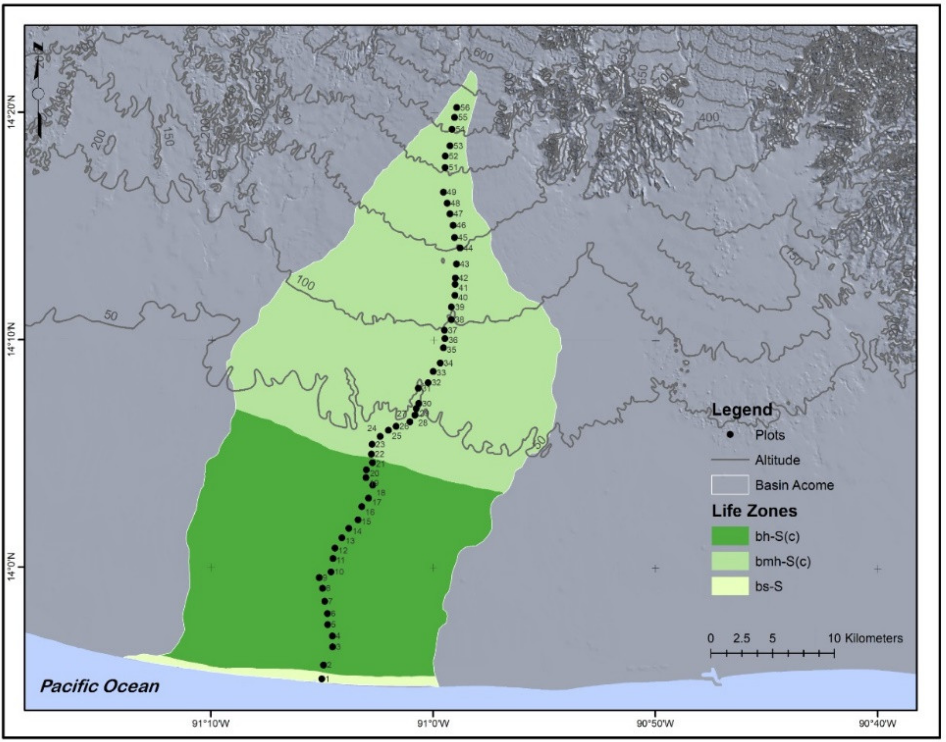
2.1. Study Site

The Acomé river is 58.48 km in length. The Acomé river basin covers an area of 893.4 km2 (344.9 sq mi) [19] and is located on the Pacific slope of Guatemala, which extends from the foothills of the volcanic mountains to the Pacific Ocean [20]. It is located in the Escuintla department, on the jurisdiction of La Democracia, La Gomera, Santa Lucía Cotzumalguapa, Sipacate and Siquinalá. Its geographical coordinates range from 13°54′00″ to 14°22′00″ North, and 90°57′00″ to 91°13′00″ West with an altitudinal range of 0 to 570 m above sea level (m a. s. l.) [21]. The mean annual rainfall ranges from 800 mm at its lowest altitude to 4600 mm in the upper regions. Maximum temperatures vary between 32 and 34 °C, while the minimums oscillate between 20 and 21 °C [22]. According to the L. Holdridge classification proposed by De la Cruz [23,24], the Acomé basin has three life zones: very humid subtropical warm-forest (bmh-S), humid subtropical warm-forest (bh-S) and dry subtropical forest (bs-S). According to the Forest Cover Map of Guatemala of 2010, only 3% of the Acomé basins area was reported to have forest cover [18]. The most important activity within the region is agriculture: predominantly sugarcane (Saccharum officinarum L.) production. The forest remnants are mainly riparian, being located along the Acomé riverbank and its tributaries and there are also mangrove forests near the sea.

2.2. Plant Sampling

Fifty-six rectangular plots of 10 × 100 m (1000 m2) were assessed. These were systematically located at 1 km intervals along the Acomé riverbank (Figure 1). At each plot, geographical coordinates and altitude were recorded using a handheld GPS (Table S1). Within each plot, measurements of all trees >10 cm diameter at breast height (DBH) were recorded as well as tree height. We photographed and collected herbarium specimens to enable identification of each plant species. The herbarium specimens consisted of branch(es) with leaves, flowers and fruits. Additional riparian tree specimens were collected ad hoc outside the plots along the river basin for identification purposes. At least 5 specimens were collected from each of the sampled tree species. Specimens were dried using a portable dryer, consisting of an electric fan heater and a metallic base. The botanical presses were placed on the base and covered with a cotton canvas (Figure S1) [25]. Most of the specimens required approximately 24 h for drying, while those with more succulent tissues required up to 60 h.

2.3. Plant Identification

Identification of plant specimens was achieved in the AGUAT Herbarium ‘Professor José Ernesto Carrillo’ of the Agronomy Faculty of the University of San Carlos of Guatemala. For identification, we used the dichotomous keys of the Flora of Guatemala [26], Flora of Nicaragua [27], Flora Mesoamericana [28] and the online databases The Plant List and World Flora Online [29,30].

2.4. Vegetation Classification

Cluster analysis on the abundance of species per plot was used to identify vegetation groups (plant communities) using Euclidean distance (as the distance measure) and Ward’s method (as a group linkage measure) [31]. The packages ‘dendextend’, ‘ggplot2’ and ‘stats’ for the R environment were used [32,33,34]. An analysis of similarity (ANOSIM) of the package ‘vegan’ was used to validate the groups obtained by cluster analysis [32,35]. To represent the ordination of the groups obtained from the cluster analysis, non-metric multidimensional scaling was performed with data on the abundance of species per tree community, using Bray–Curtis dissimilarity index through ‘vegan’ package for R [32,35].

2.5. Floristic Composition and Species Diversity

The importance value index (IV) was estimated for the species in each community with data on the abundance and basal area per species per plot with the package ‘BiodiversityR’ [32,36]. Diversity indices were estimated for each plot using the package ‘vegan’ to thereafter estimate the average value per tree community [32,35].

3. Results

3.1. Tree Species Identification

One hundred and fifteen (115) tree species were identified along the Acomé riverbank, belonging to 91 genera and 43 families (Table 1).

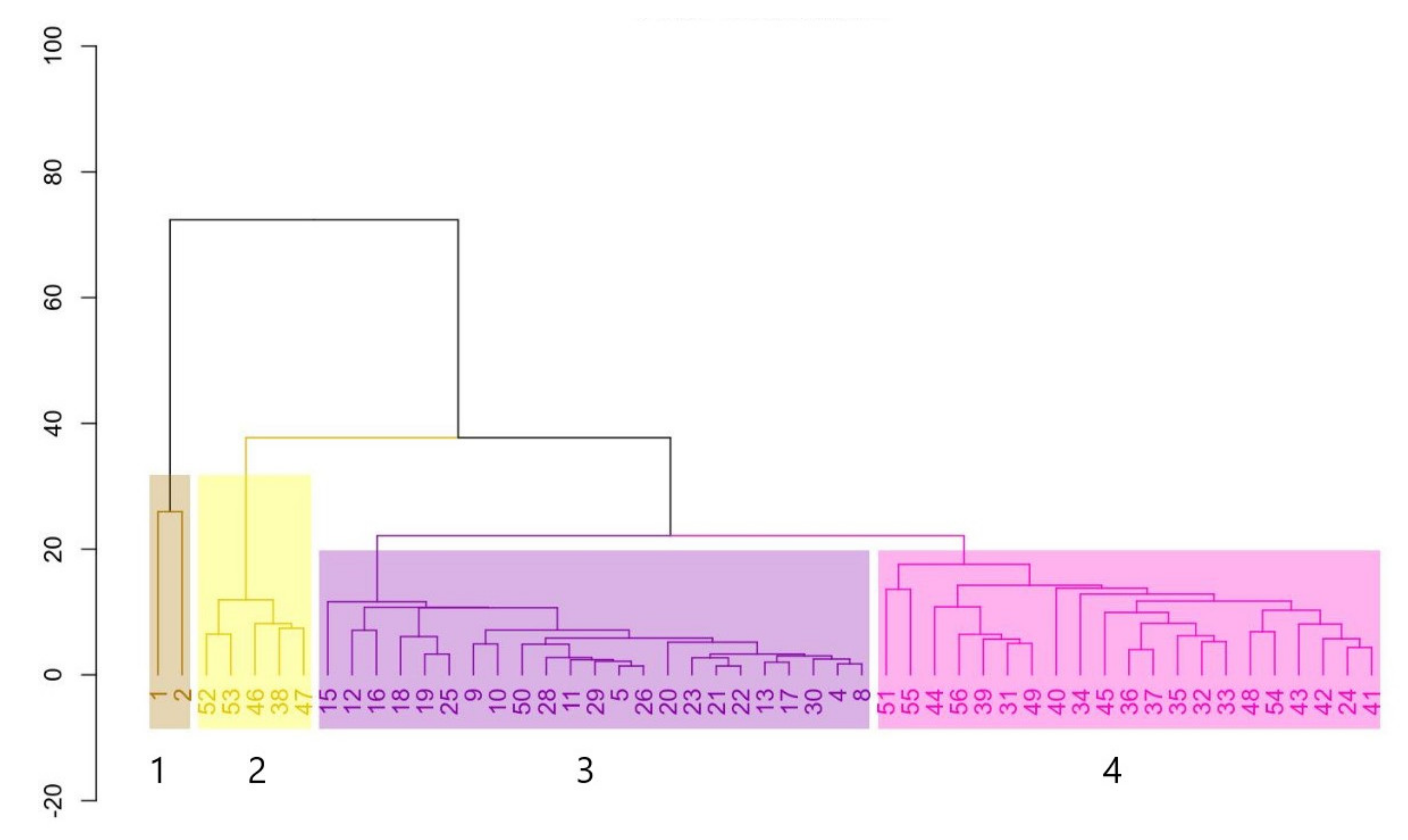
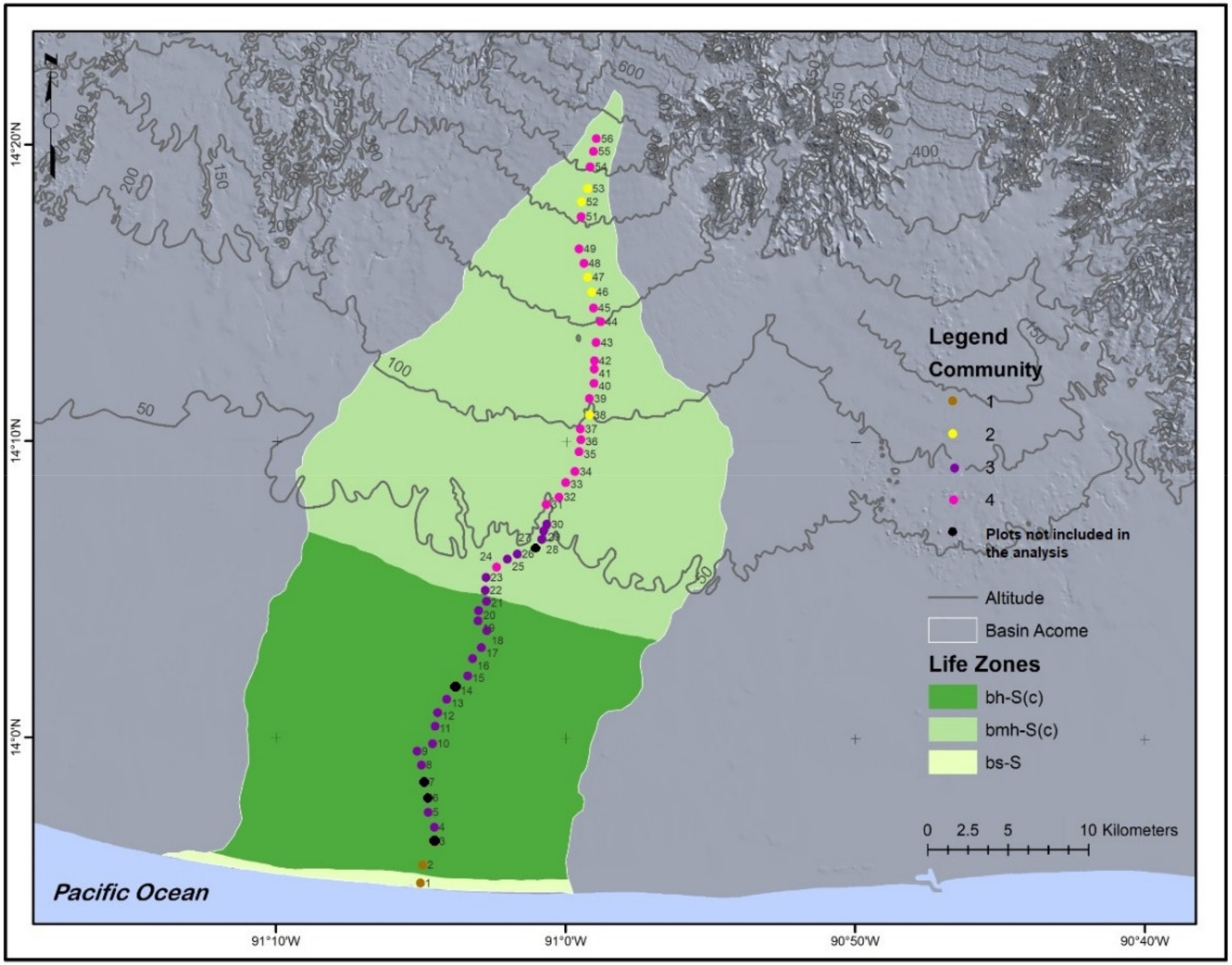
3.2. Vegetation Classification

Classification of the vegetation was made through cluster analysis on the abundance of species per plot. Five of the 56 plots (3, 6, 7, 14 and 27) were not included in the analysis, as they were located on heavily disturbed areas. The cluster analysis identified four groups of vegetation along an altitudinal gradient (Figure 2). The analysis of similarity (ANOSIM) showed that the formed clusters were well separated (R = 0.55), and that the separation was significant (p = 0.001). To verify and validate the groups obtained through cluster analysis, a non-metric multidimensional scaling was performed. The results support the grouping in the ordination graph (Figure S2).

3.3. Floristic Composition in the Riparian Tree Communities

Of the 115 species collected along the river basin, only 69 were within the sampling plots, which represents 60% of the species. Riparian tree community 1 is located at sea level on the Pacific coast, where 118 trees were sampled belonging to 12 species. Riparian community 2 is located above 100 m a.s.l., where 167 trees were sampled belonging to 28 species. Community 3 is located at around 50 m a.s.l., where 172 trees were sampled belonging to 31 species, and community 4 is located between 50 and 546 m a.s.l., where 463 trees were sampled belonging to 54 species (Figure 3).
The four major or dominant species in each riparian tree community and their importance values are shown in Table 2.

3.4. Species Diversity of the Riparian Tree Communities

Table 3 shows the diversity indices for each riparian tree community of the Acomé river. According to the indices, community 1 had the lowest diversity and evenness values, with R. mangle as a dominant species. Community 2 had intermediate diversity and evenness values, with C. obtusifolia being the dominant species. Communities 3 and 4 had the highest evenness values (above 0.9), but diversity was ranked second lowest for community 3 and highest for community 4. G. ulmifolia and B. costaricanum were the dominant species in communities 3 and 4, respectively.

4. Discussion

This study provides a detailed tree characterization of the Acomé riverbank, reporting 115 tree species belonging to 91 genera and 43 families. A study investigating tree diversity in tropical riparian forest fragments in the Mountain Pine Ridge savannah in Belize (400 to 1000 m a.s.l.) found similar numbers, with 106 morphospecies, 78 genera and 42 families in micro-forests and 117 morphospecies, 71 genera and 41 families in tree thickets [37]. However, the floristic composition of both studies is remarkably different, possibly due to differences in the altitudinal and latitudinal range.
Most of the tree species reported in this study such as A. hindsii, A. purpurea, C. guatemalensis and S. salvadorensis are native to Mesoamerica, with one, S. salvadorensis, being listed in the Red List of Trees of Guatemala [38]. However, there are non-native species in the list, such as G. arborea (originally from Asia) D. regia (originally from Madagascar), L. sericeus (originally from Mexico) and S. campanulate (originally from Africa) indicating that at least some of the species found in this region are introduced or exotic. Introduced species are usually the result of anthropogenic activities, and the vicinity of riparian habitats may facilitate their establishment and spread [39]. Therefore, efforts to predict their occurrence, manage areas of high abundance and prevent further spread must be included in future management programs [39].
We identified four riparian tree communities in the Acomé river basin along an altitudinal gradient, where the species R. mangle, C. obtusifolia, G. ulmifolia, and B. costaricanum were dominant. The communities are very consistent with the bioclimatic classification of life zones at the recognition level inferred by L. Holdridge as suggested by De la Cruz [23,24]. Community 1 overlaps with the dry subtropical forest life zone (bs-S). Community 3 coincides with the humid subtropical warm-forest zone (bh-S) and has secondary forest trees as its dominant species. Riparian tree communities 2 and 4 are included in the very wet subtropical warm-forest zone (bmh-S) and have different dominant species, but these are all distinctive of secondary forests [26,27], suggesting intermediate successional stages.
Dominant species may naturally differ between communities due to the azonal condition of the vegetation inherent to the riparian habitat [8]. Factors affecting the distribution and composition of the species in these communities include altitude, edaphic factors and anthropogenic intervention (especially fires) [40]. Therefore, we strongly suggest that future studies incorporate ecological predictors including soil properties, distance from river course, depth of the groundwater table, landscape cover surrounding the plot and disturbance effects (e.g., fire history) in order to explain the observed differences.
We estimated the average species richness or number of species (s), the average evenness that indicates the relative abundance of species (J’) and the average Simpson diversity (Ds) for each tree community. Community 1, located in the mangrove ecosystem, had a lower richness (8 species), evenness (0.64) and diversity (0.63) when compared with the other communities. This is expected, as only a few halophytic species, such as mangroves, can survive under the high-salinity conditions of river estuaries [41]. However, despite having a low diversity and evenness, mangroves serve important ecological roles, providing mating and nesting habitats for a variety of birds and aquatic fauna [41]. Furthermore, from the four identified communities, the mangrove community is the least disturbed by anthropogenic activities, as it is located within a protected area (the Sipacate-Naranjo Natural Park).
The remaining communities include tree species characteristic of secondary forests which are surrounded by sugarcane plantations, urban zones and grazing areas. Despite being located near heavily disturbed areas, communities 2, 3 and 4 have a relatively high evenness (0.78, 0.92 and 0.91, respectively) and diversity (0.77, 0.7 and 0.89, respectively).
Currently, secondary forests cover extensive areas across Central America. These mostly originate from the natural regeneration of previously deforested land from the native seedbank rather than from intentional reforestation efforts [42]. Secondary forests are positioned among the most significant sources of biodiversity and carbon reservoirs on earth, serving as both habitats for wildlife and regulators of the carbon cycle [2]. However, the capability of these secondary forests in regaining the biological features and diversity of an undisturbed primary forest is still poorly understood [2,9], as is the contribution of secondary forest remnants in fragmented landscapes in maintaining diversity across agricultural matrices [43].
This study can be used as a reference for the riparian tree vegetation of the Pacific lowlands of Guatemala. Further studies are needed to characterize secondary forests of the region in detail to monitor change over time, create predictive models, and establish conservation priorities. We acknowledge that this work is limited by the lack of ecological data (e.g., soil properties, distance from a river course and disturbance effects) needed to explain the observed patterns and suggest that future research incorporates ecological predictors in order to address this. We also suggest the inclusion of other vegetation strata, such as shrubs, herbs, lianas, epiphytic plants and aquatic plants, in future studies. A more accurate representation of the riparian vegetation composition is essential to support future ecological restoration projects, the reintroduction of native species, the management of exotic species and other in situ conservation efforts.

5. Conclusions and Future Outlook

Presently, the loss and fragmentation of forests due to changes in land use is considered one of the greatest threats to global biodiversity, particularly in the tropics. In tropical regions that have lost most of their forest cover, it is essential to consider the remaining forest patches as a priority for conservation [37,44,45]. In the Pacific lowlands of Guatemala, most of the remnant forests are located along riverbanks. However, their riparian tree community composition and biodiversity status are poorly known. This study provided a list of plant species and identified tree communities along the Acomé river, in the Pacific slope of Guatemala. We found many native tree species, but exotic tree species were also recorded along the river basin, supporting the need for urgent conservation and restoration efforts. This study can be used as a reference by local landscape managers and government or conservation organizations. We consider that restoring riparian forests should be a priority in the region, with a focus on native species, as they are more likely to support native fauna. More studies at a local and regional scale, including detailed ecological information and disturbance impacts, are needed to accurately assess and monitor biodiversity and identify conservation priorities [46].

Supplementary Materials

The following are available online at https://www.mdpi.com/article/10.3390/f12070898/s1, Table S1: Location of the sampling plots along the Acomé riverbanks; Figure S1: System used to dry botanical specimens; and Figure S2: Non-metric multidimensional scaling with data on the abundance of species per tree community.

Author Contributions

Conceptualization and methodology A.A.P., J.J.C.M. and D.E.M.J.; data collection A.A.P.; J.J.C.M., and D.E.M.J.; data analysis A.A.P. and J.J.B.; revision and discussion A.A.P., A.C.M., A.G.N., D.E.M.J. and J.J.B.; manuscript written by A.A.P. and A.C.M. All authors have read and agreed to the published version of the manuscript.

Funding

This research was funded by The Private Institute for Climate Change Research (ICC).

Institutional Review Board Statement

Not applicable.

Informed Consent Statement

Not applicable.

Data Availability Statement

The data that support the findings of this study are available from the corresponding authors upon reasonable request.

Acknowledgments

We are grateful to the technical team of the Integrated Watershed Management Program of the Private Institute for Climate Change Research for the support provided in the field and for providing the financial assistance to carry out this research. We also especially want to thank Nereyda Trabanino, Conrado Gámez and Carlos Tivo for their support and assistance during the field phase, to Amy Molina for her support with map editing. We are grateful to Paul Barrett for proofreading the final version of the manuscript, and to Massey University for supporting open access publication.

Conflicts of Interest

The authors declare no conflict of interest.

References

  1. Laurance, W.F.; Sayer, J.; Cassman, K.G. Agricultural expansion and its impacts on tropical nature. Trends Ecol. Evol. 2014, 29, 107–116. [Google Scholar] [CrossRef]
  2. Phalan, B.; Bertzky, M.; Butchart, S.H.; Donald, P.F.; Scharlemann, J.P.; Stattersfield, A.J.; Balmford, A. Crop expansion and conservation priorities in tropical countries. PLoS ONE 2013, 8, e51759. [Google Scholar]
  3. Sempris, E.; Carrillo, R.; Portillo, R.H.O.; Carranza, A.C.; Fuller, C.; Peters, R.E.; Stokes, C.; Castañon, C.C.; Irwin, D.; Barraza, E. Potential Impacts of Climate Change on Biodiversity in Central America, Mexico and the Dominican Republic; Water Center for the Humid Tropics of Latin America and the Caribbean: Panama City, Panama, 2008. [Google Scholar]
  4. DeClerck, F.A.; Chazdon, R.; Holl, K.D.; Milder, J.C.; Finegan, B.; Martinez-Salinas, A.; Imbach, P.; Canet, L.; Ramos, Z. Biodiversity conservation in human-modified landscapes of Mesoamerica: Past, present and future. Biol. Conserv. 2010, 143, 2301–2313. [Google Scholar] [CrossRef]
  5. Dos Santos, F.B.; Ferreira, F.C.; Esteves, K.E. Assessing the importance of the riparian zone for stream fish communities in a sugarcane dominated landscape (Piracicaba River Basin, Southeast Brazil). Environ. Biol. Fishes 2015, 98, 1895–1912. [Google Scholar] [CrossRef]
  6. Collier, K.; Cooper, A.; Davies-Colley, R.; Rutherford, J.; Smith, C.; Williamson, R.B. Managing Riparian Zones: A Contribution to Protecting New Zealand’s Rivers and Streams; Department of Conservation: Wellington, New Zealand, 1995; Volume 2. [Google Scholar]
  7. Stanley, V.; Swanson, F.; Mckee, W.; Cummins, K. An Ecosystem Perspective of Riparian Zones, Focus on links between land and water. Bioscience 1991, 41, 540–551. [Google Scholar]
  8. Van Der Maarel, E.; Franklin, J. Vegetation ecology: Historical notes and outline. Veg. Ecol. 2013, 2, 1–27. [Google Scholar]
  9. Burton, M.L.; Samuelson, L.J.; Pan, S. Riparian woody plant diversity and forest structure along an urban-rural gradient. Urban Ecosyst. 2005, 8, 93–106. [Google Scholar] [CrossRef]
  10. Gregory, S.V.; Swanson, F.J.; McKee, W.A.; Cummins, K.W. An ecosystem perspective of riparian zones. BioScience 1991, 41, 540–551. [Google Scholar] [CrossRef]
  11. Naiman, R.J.; Decamps, H.; McClain, M.E. Riparia: Ecology, Conservation, and Management of Streamside Communities; Elsevier: Amsterdam, The Netherlands, 2010. [Google Scholar]
  12. Naiman, R.J.; Decamps, H.; Pollock, M. The role of riparian corridors in maintaining regional biodiversity. Ecol. Appl. 1993, 3, 209–212. [Google Scholar] [CrossRef]
  13. Pysek, P.; Prach, K. How important are rivers for supporting plant invasions. In Ecology and Management of Invasive Riverside Plants; John Wiley & Sons Ltd.: Chichester, UK, 1994; pp. 19–26. [Google Scholar]
  14. Sunil, C.; Somashekar, R.; Nagaraja, B. Impact of anthropogenic disturbances on riparian forest ecology and ecosystem services in Southern India. Int. J. Biodivers. Sci. Ecosyst. Serv. Manag. 2011, 7, 273–282. [Google Scholar] [CrossRef] [Green Version]
  15. Naiman, R.J. New perspectives for watershed management: Balancing long-term sustainability with cumulative environmental change. In Watershed Management; Springer: New York, NY, USA, 1992. [Google Scholar]
  16. NSW Government. Guidelines for Riparian Corridors on Waterfront Land; Department of Trade and Investment, Regional Infrastructure and Services: Parramatta, Australia, 2018.
  17. Platts, W.S. Methods for Evaluating Riparian Habitats with Applications to Management; US Department of Agriculture, Forest Service, Intermountain Research Service: Ogden, UT, USA, 1987; Volume 221.
  18. Regalado, O.; Villagrán, X.; Pérez, G.; Castellanos, E.; Martínez, G.; Incer, D. Mapa de Cobertura Forestal de Guatemala 2010 y Dinámica de la Cobertura Forestal 2006–2010; National Forestry Institute (INAB), National Council for Protected Areas (CONAP), Universidad del Valle de Guatemala, Universidad Rafael Landívar: Guatemala City, Guatemala, 2012.
  19. MAGA. Capa Digital a Escala 1:50,000 de la República de Guatemala; Ministerio de Agricultura, Ganadería y Alimentación de Guatemala (MAGA): Guatemala City, Guatemala, 2009.
  20. Herrera Ibáñez, I.R. Manual de hidrología. In Facultad de Agronomía; Universidad de San Carlos de Guatemala: Guatemala City, Guatemala, 1995. [Google Scholar]
  21. CONRED. Mapa de Elevación Dígital 12.5; Coordinadora Nacional para la Reducción de Desastres: Guatemala City, Guatemala, 2016. [Google Scholar]
  22. ICC. Resumen Meteorológico: Resultados del Sistema Meteorológico ICC; Instituto Privado de Investigación sobre Cambio Climático: Santa Lucía Cotzumalguapa, Guatemala, 2015; 31p. [Google Scholar]
  23. De la Cruz, R. Clasificación de Zonas de vida de Guatemala Basada en el Sistema Holdridge; Instituto Nacional Forestal: Guatemala, 1976. [Google Scholar]
  24. IARNA-URL (Instituto de Investigación y Proyección sobre Ambiente Natural y Sociedad de la Universidad Rafael Landívar). Ecosistemas de Guatemala Basado en el Sistema de Clasificación de Zonas de Vida; Instituto de Investigación y Proyección sobre Ambiente Natural y Sociedad de la Universidad Rafael Landívar: Guatemala City, Guatemala, 2018. [Google Scholar]
  25. Blanco, M.A.; Whitten, W.M.; Penneys, D.S.; Williams, N.H.; Neubig, K.M.; Endara, L. A simple and safe method for rapid drying of plant specimens using forced-air space heaters. Selbyana 2006, 27, 83–87. [Google Scholar]
  26. Standley, P.C.; Steyermark, J.A. Flora of Guatemala. V. Fieldiana Bot. 1946, 24, 502. [Google Scholar]
  27. Stevens, W.D.; Ulloa, C.; Pool, A.; Montiel, O.M. Flora de Nicaragua; Missouri Botanical Garden Press: St. Louis, MO, USA, 2001; Volume 85. [Google Scholar]
  28. Flora Mesoamericana; British Museum of Natural History: London, UK, 1995.
  29. The Plant List, Version 1.1. 2013: Published on the Internet. Available online: http://www.theplantlist.org/ (accessed on 15 January 2021).
  30. WFO. World Flora Online. 2021: Published on the Internet. Available online: http://www.worldfloraonline.org/ (accessed on 15 January 2021).
  31. Gauch, H.G.; Gauch, H.G., Jr. Multivariate Analysis in Community Ecology; Cambridge University Press: Cambridge, UK, 1982. [Google Scholar]
  32. R Core Team. R: A Language and Environment for Statistical Computing; R Core Team: Vienna, Austria, 2013. [Google Scholar]
  33. Galili, T. Dendextend: An R package for visualizing, adjusting and comparing trees of hierarchical clustering. Bioinformatics 2015, 31, 3718–3720. [Google Scholar] [CrossRef] [Green Version]
  34. Wickham, H. Ggplot2: Elegant Graphics for Data Analysis; Springer: New York, NY, USA, 2009. [Google Scholar]
  35. Oksanen, J.; Blanchet, F.; Friendly, M.; Kindt, R.; Legendre, P.; McGlinn, D.; Minchin, P.; O’Hara, R.; Simpson, G.; Solymos, P. Vegan: Community Ecology Package. R Package Version 2.5-6. 2019; Boston, MA, USA, 2019. [Google Scholar]
  36. Kindt, R. BiodiversityR: Package for Community Ecology and Suitability Analysis, Version 2.7-1; 2016. [Google Scholar]
  37. Pither, R.; Kellman, M. Tree species diversity in small, tropical riparian forest fragments in Belize, Central America. Biodivers. Conserv. 2002, 11, 1623–1636. [Google Scholar] [CrossRef]
  38. Vivero, J.L.; Szejner, M.; Gordon, J.; Magin, G. The Red List of Trees of Guatemala; UNEP: Ginebra, Switzerland; IUCN: Gland, Switzerland; FFI: Cambridge, UK; BGCI: Surrey, UK, 2006. [Google Scholar]
  39. Hoffman, J.D.; Narumalani, S.; Mishra, D.R.; Merani, P.; Wilson, R.G. Predicting potential occurrence and spread of invasive plant species along the North Platte River, Nebraska. Invasive Plant Sci. Manag. 2008, 1, 359–367. [Google Scholar] [CrossRef]
  40. Ríos, B.; Raga, G.B. Spatio-temporal distribution of burned areas by ecoregions in Mexico and Central America. Int. J. Remote Sens. 2018, 39, 949–970. [Google Scholar] [CrossRef]
  41. Lugo, A.E.; Snedaker, S.C. The ecology of mangroves. Annu. Rev. Ecol. Syst. 1974, 5, 39–64. [Google Scholar] [CrossRef]
  42. Henao Bravo, E.I.; Ordóñez, Y.; Camino Velozo, R.D.; Soto, R.V.; Gambeta, F.C. El Bosque Secundario en Centroamérica: Un Recurso Potencial de uso Limitado por Procedimientos y Normativas Inadecuadas; CATIE: Cartago, Costa Rica, 2015. [Google Scholar]
  43. Fahrig, L. Habitat fragmentation: A long and tangled tale. Glob. Ecol. Biogeogr. 2019, 28, 33–41. [Google Scholar] [CrossRef]
  44. Wilson, E.O. Threats to biodiversity. Sci. Am. 1989, 261, 108–117. [Google Scholar] [CrossRef]
  45. Chazdon, R.L.J.S. Tropical forests—Log’em or leave’em? Science 1998, 281, 1295–1296. [Google Scholar] [CrossRef]
  46. Noss, R.F. Assessing and monitoring forest biodiversity: A suggested framework and indicators. For. Ecol. Manag. 1999, 115, 135–146. [Google Scholar] [CrossRef]
Figure 1. Acomé river basin with its life zones and distribution of the sampling plots.
Forests 12 00898 g001
Figure 2. Cluster analysis based on species abundance data, in 51 0.1-hectare plots on the banks of the Acomé River, using Euclidean distance and Ward’s method. Plots are grouped on the horizontal axis, while the vertical axis indicates the degree of proportional similarity between the species within the plots. Clusters are numbered 1 to 4.
Forests 12 00898 g002
Figure 3. Distribution of tree communities on the banks of the Acomé River.
Forests 12 00898 g003
Table 1. Updated list of the tree species found in the Acomé riverbank (nomenclature following Angiosperm Phylogeny Group system).
FamilySpeciesCommon Name
AcanthaceaeAvicennia germinans (L.) L.Mangle negro
AnacardiaceaeSpondias mombin L.Jocote jobo
Annonaceae Annona purpurea Moc. & Sessé ex DunalChincuya
Rollinia mucosa (Jacq.) Baill.Anona
ApocynaceaeAspidosperma megalocarpon Müll.Arg.Chichique
Tabernaemontana donnell-smithii Rose ex J.D.Sm.Cojón
AraliaceaeDendropanax arboreus (L.) Decne. & Planch.Mano de león
BignoniaceaeCrescentia cujete L.Morro
Spathodea campanulata P.Beauv.Llama del bosque
Tabebuia rosea (Bertol.) Bertero ex A.DC.Matilisguate
BoraginaceaeCordia alba (Jacq.) Roem. & Schult.Tigüilote, Upay
Cordia alliodora (Ruiz & Pav.) OkenLaurel
BurseraceaeBursera simaruba (L.) Sarg.Palo de jiote
CactaceaeCynometra retusa Britton & Rose
CannabaceaeCeltis iguanaea (Jacq.) Sarg.
Trema micrantha (L.) BlumeCapulín
ChrysobalanaceaeChrysobalanus icaco L.Icaco
Clethraceae Clethra mexicana DC.Zapotillo
ClusiaceaeCalophyllum brasiliense var. rekoi (Standl.) Standl.Palo mario
Clusia guatemalensis Hemsl.
CombretaceaeConocarpus erectus L.Botoncillo
Laguncularia racemosa (L.) C.F.Gaertn.Mangle blanco
Terminalia arborea Koord.Volador
DichapetalaceaeDichapetalum donnell-smithii Engl.
EbenaceaeDiospyros nigra (J.F.Gmel.) Perrier
FabaceaeAcacia cornigera (L.) Willd.Ixcanal blanco
Acacia hindsii Benth.Ixcanal negro
Acacia polyphylla DC.Alacrán
Albizia adinocephala (Donn.Sm.) RecordConacaste blanco
Albizia saman (Jacq.) Merr.Cenicero
Andira inermis (Wright) DC.Almendro cimarrón
Calliandra magdalenae var. colombiana (Britton & Killip) BarnebyChalí
Dalbergia cuscatlanica (Standl.) Standl. Granadillo
Delonix regia (Hook.) Raf.Flambollano
Diphysa americana (Mill.) M.SousaGuachipilín
Enterolobium cyclocarpum (Jacq.) Griseb.Conacaste
Erythrina mexicana KrukoffPalo de pito
Gliricidia sepium (Jacq.) Walp.Madrecacao
Hymenaea courbaril L. Guapinol
Inga edulis Mart.Cuje
Inga laurina (Sw.) Willd.Caspirol
Inga paterno HarmsPaterna
Inga sapindoides Willd.Cushin
Lonchocarpus macrocarpus Benth.Quebracho
Lonchocarpus salvadorensis PittierChaperno
Lonchocarpus sericeus (Poir.) DC.Matabuey
Pithecellobium dulce (Roxb.) Benth.Guachimol
Platymiscium dimorphandrum Donn.Sm.Hormigo
Poeppigia procera C.PreslTepemisque
Schizolobium parahyba (Vell.) S.F.BlakePlumillo
Senna reticulata (Willd.) H.S.Irwin & BarnebyVarajito, Arípin
Senna spectabilis (DC.) H.S.Irwin & Barneby
Vatairea lundellii (Standl.) RecordPalo negro
LamiaceaeGmelina arborea Roxb.Melina
LauraceaeNectandra membranacea (Sw.) Griseb.
Ocotea sinuata (Mez) RohwerCanoj
LythraceaeLagerstroemia indica L.
MalpighiaceaeBunchosia guatemalensis Nied.
Bunchosia odorata (Jacq.) Juss.
Byrsonima crassifolia (L.) KunthNance
MalvaceaeGuazuma ulmifolia Lam.Caulote
Hampea rovirosae Standl.
Heliocarpus donnellsmithii Rose
Pachira aquatica Aubl.Pumpujush, zapotón, pumpo
Quararibea funebris (La Llave) VischerMolinillo
Sterculia apetala (Jacq.) H.Karst.Castaño
Trichospermum mexicanum (DC.) Baill.Cajete
MelastomataceaeConostegia xalapensis (Bonpl.) D. Don ex DC.
Miconia laevigata (L.) D. Don Cacho de venado
MeliaceaeGuarea glabra VahlAnicillo
Guarea megantha A.Juss.Trompillo
Swietenia macrophylla KingCaoba
Trichilia havanensis Jacq.
Trichilia martiana C.DC.Chile amate
MoraceaeBrosimum costaricanum Liebm.Ujushte, Ramón
Castilla elastica Cerv.Palo de hule
Ficus aurea Nutt.Amate
Ficus benjamina L.Amate
Ficus costaricana (Liebm.) Miq.Amate
Ficus crocata (Miq.) Mart. ex Miq.Amate
Ficus hemsleyana KingAmate
Ficus insipida Willd.Amate
Ficus maxima Mill.Amate
Ficus obtusifolia KunthAmate
Ficus pertusa L.f.Amate
Ficus sp.Amate
Maclura tinctoria (L.) D.Don ex Steud.Mora
Trophis racemosa (L.) Urb.
MuntingiaceaeMuntingia calabura L. Capulín blanco
NyctaginaceaeNeea psychotrioides Donn.Sm.Siete camisas
OlacaceaeXimenia americana L.
PhyllanthaceaeAstrocasia austinii (Standl.) G.L.WebsterPimiento
PolygonaceaeCoccoloba barbadensis Jacq.Papaturro
Coccoloba escuintlensis LundellPapaturro
Triplaris melaenodendron (Bertol.) Standl. & Steyerm.Mulato
PrimulaceaeBonellia macrocarpa (Cav.) B.Ståhl & KällersjöNaranjillo
RhamnaceaeColubrina arborescens (Mill.) Sarg.Coshte
RhizophoraceaeRhizophora mangle L. Mangle Rojo
RubiaceaeHamelia patens Jacq.Chichipín
Psychotria limonensis K.Krause
Simira salvadorensis (Standl.) Steyerm.Puntero
RutaceaeZanthoxylum riedelianum subsp. kellermanii (P.Wilson) Reynel ex C.NelsonLagarto
SalicaceaeCasearia arguta KunthRaspa lengua
Salix humboldtiana Willd.Sauce
SapindaceaeSapindus saponaria L.Jaboncillo
SapotaceaePouteria sapota (Jacq.) H.E.Moore & StearnZapote
Sideroxylon capiri subsp. tempisque (Pittier) T.D.Penn.Tempisque
Sideroxylon celastrinum (Kunth) T.D.Penn.
Sideroxylon capiri (A.DC.) PittierTempisque
SimaroubaceaeSimarouba amara Aubl.Aceituno
SolanaceaeCestrum racemosum Ruiz & Pav.Huele de noche
Solanum diphyllum L.
StaphyleaceaeTurpinia occidentalis (Sw.) G.Don
UrticaceaeCecropia obtusifolia Bertol.Guarumo
VerbenaceaeCitharexylum affine D.DonCola de iguana
Table 2. Importance values (IVs) of dominant species of the riparian tree communities along the Acomé riverbank.
CommunitySpeciesIV (%)
1Rhizophora mangle L. 41.6
Avicennia germinans (L.) L.22.7
Pithecellobium dulce (Roxb.) Benth.6.8
Laguncularia racemosa (L.) C.F.Gaertn.5.6
2Cecropia obtusifolia Bertol.19.1
Guazuma ulmifolia Lam.10.9
Andira inermis (Wright) DC.8.8
Ficus aurea Nutt.7.7
3Guazuma ulmifolia Lam.18.4
Ceiba pentandra (L.) Gaertn.17.3
Enterolobium cyclocarpum (Jacq.) Griseb.11.3
Salix humboldtiana Willd.7.2
4Brosimum costaricanum Liebm.9.2
Acacia polyphylla DC.7.7
Cecropia obtusifolia Bertol.7.0
Ceiba pentandra (L.) Gaertn.5.9
Table 3. Species diversity indices for the riparian tree communities of the Acomé riverbank.
Diversity Index Riparian Tree Community
1234
Number of plots252321
Total number of species12283154
Richness per plot (s) *810.84.211.3
Evenness (J’) *0.640.780.920.91
Simpson diversity (Ds) *0.630.770.70.89
Note: Fields marked with asterisk (*) represent mean values for each group.
Publisher’s Note: MDPI stays neutral with regard to jurisdictional claims in published maps and institutional affiliations.

