1. Introduction
Increasingly, extreme wildfire events are overwhelming fire management systems’ capability to control fire and limit its impacts [
1,
2,
3]. The increasing complexity and uncertainty of the socio-ecological fire environment are driven by multiple factors, including climate change [
4,
5], changing patterns of human settlement (e.g., housing expansion in the United States [
6,
7], rural abandonment in Mediterranean Europe [
8,
9]), and increased fuel loading due to a history of suppression [
10,
11,
12]. Within the United States, there is growing recognition that systemic changes in how the wildland fire system plans for and manages fires are necessary to alter risk trajectories [
2,
3,
13,
14,
15,
16].
Safe, effective, and risk-informed response to wildfire is a pillar of the National Cohesive Wildland Fire Management Strategy. In recent years, the concept of safe and effective response within federal wildfire management agencies in the US has transitioned from one that is focused largely on individual responsibility (see, for example, the US Forest Service Safety Journey [
17]) toward a more corporate risk management approach that incorporates strategic risk assessment, structured decision-making, and accountability [
18]. This transition has emerged in part through the recognition that much of the exposure of personnel to the hazards of the wildfire environment is determined at the strategic level, through choices such as which resources to mobilize, when and where to deploy them, and what tasks to accomplish. For example, a traditional aviation safety-based approach would focus on the conditions of the equipment, environmental factors, and pilot decision-making. A strategic exploration would include these as well but would also include an assessment of how the assignment supports strategic incident objectives and if those incident objectives are aligned with organizational priorities (see, for example [
19]). Fully embracing risk management principles in wildfire decision-making will likely require a significant change to the historic large fire management structure and the organizational culture of aggressive suppression as the dominant paradigm [
20].
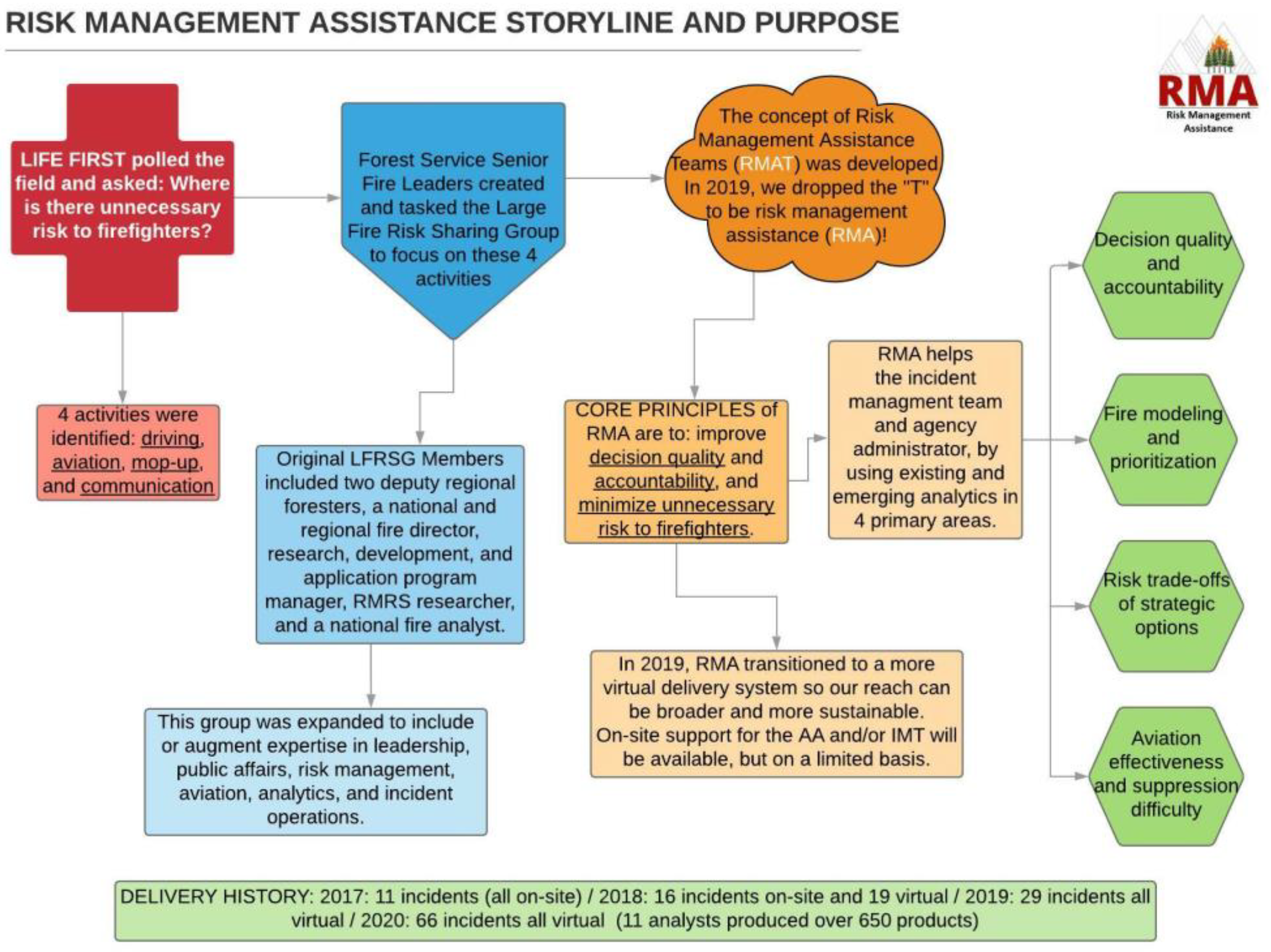
In December 2016, Forest Service senior leadership tasked a sub-group to explore opportunities to improve the strategic alignment of critical decisions on large wildfires, bringing the Agency’s values in alignment with those articulated in the Life First initiative [
21]. Although risk management had been identified as the cornerstone of wildfire management since at least the 1995 Federal Wildland Fire Management Policy [
22] and reiterated in 2009 guidance [
23], the application of risk management concepts had largely been executed at the operational or real-time levels. The intention of broadening the scope to strategic decisions and perspectives was challenged by several organizational constraints, such as uncertainty, misaligned incentive structures, goal ambiguity, and limited formal training and education [
24]. Thompson et al. [
18] provided specific recommendations to improve the adoption of risk management in federal wildfire management in the three areas of leadership, education, and capacity, and in assessment and planning. One particularly salient example is: “As a near-term solution, assemble and deploy a set of interdisciplinary consulting teams to provide the necessary expertise and guidance in risk-based decision support”.
With those themes in mind, risk management assistance (RMA) was designed to assist local land and fire management decision-makers (frequently known as agency administrators (AAs) in US federal land-management agencies) and incident management teams (IMTs) in making high-quality, risk-informed decisions. RMA achieved this by providing access to experienced AAs, IMTs, and subject matter experts in risk management and fire operations, and by delivering enhanced fire analytics. The intent of the RMA program was to apply existing and emerging decision support tools, coupled with risk management expertise, to improve the overall effectiveness and efficiency of wildfire response, doing so in a manner that emphasized the co-production of knowledge and worked across traditionally siloed fire management functions. By focusing on individual, complex large wildfire events, RMA explored opportunities for and barriers to accelerating the adoption of more formal risk-informed decision-making practices in wildfire management.
In this article, we describe our engagement and experience with the RMA program. In
Section 2, we briefly review relevant literature on the characteristics of decision-making on wildland fire and emerging recommendations to improve strategic response planning. In
Section 3, we describe the development of the RMA program and how components of the RMA process fit into a risk-management cycle. In
Section 4, we provide four example applications of RMA in supporting different components of large, complex wildfires. In
Section 5, we discuss how decision support and information delivery have evolved over time and identify research needs and opportunities for further improvement in wildfire decision-making.
2. Supporting Strategic Wildfire Response Decision-Making
Large, long-duration wildfires (fires that burn multiple thousands of hectares and that last for weeks or even months) can be highly uncertain events, creating a complex strategic and operational decision-making environment, influenced by factors such as sociopolitical pressure and subject to myriad cognitive biases [
24,
25,
26,
27,
28]. We focus on these fires because they can pose significant safety concerns, result in high levels of expenditures and damages, and resist control efforts. Furthermore, large fires entail dynamic and adaptive decisions where time pressure and uncertainty challenge efforts to evaluate and compare alternative options based on factors such as safety and the probability of success [
29].
Some authors have suggested that decisions within this environment align with the recognition primed decision-making (RPD) construct [
30,
31]. Due to time pressure or ill-defined goals, individuals utilizing RPD do not routinely evaluate alternatives but rather utilize their experience and familiarity with the situation to identify a single course of action and modify that strategy until it feels acceptable [
32]. The likelihood that experts using RPD can consistently make high-quality decisions requires that the decision environment is of high validity, i.e., that the relationships between signals and events are relatively stable and the outcomes from actions are readily observable [
33]. The dynamic and unpredictable nature of the large fire environment, the breadth of strategies and tactics to address multiple and often competing objectives, and the lack of structured feedback on suppression effectiveness suggest that reliance on RPD for strategic wildfire response may be inappropriate [
34]. Transitioning from RPD to more structured forms of decision-making requires reducing the time pressure through more efficient information gathering/delivery, and by clarifying wildfire management incident objectives and alternatives through enhanced risk and decision analysis. In other words, there is a need to enhance both the informational content on which decisions are based and the process by which those decisions are reached [
35,
36]
In response to the increasing complexity and risk of wildfire, there is an emerging body of literature focused on improving fire management decision processes. This entails, for example, the study of factors influencing fire manager decision-making, the study of factors influencing the adoption of fire science and decision support, a review and synthesis of decision support trends and needs, and the design and delivery of next-generation decision support (e.g., [
14,
25,
31,
34,
37,
38,
39,
40,
41,
42,
43,
44]). In the US, existing large fire decision support systems provide a range of services, such as spatial analysis, fire behavior modeling, hazard and risk assessment, and decision documentation [
45,
46]. However, they offer only limited functionality to support the evaluation of alternative strategies with an emphasis on a safe and effective response. The RMA program is in part intended to bridge that gap.
3. RMA in Concept and in Practice
3.1. Framework Design
RMA was designed by a small interdisciplinary team of line officers, experienced incident management participants, and researchers, with a focus on improving decision quality on the largest, most complex events. The team identified a small number of emerging research products to help support the development and evaluation of multiple strategic alternatives. With this goal in mind, the team recruited additional participants in wildfire operations, analytics, safety, and risk management to support fire decisions by traveling to and working directly with the managers of ongoing incidents in the summer of 2017. By incorporating individuals with a variety of wildfire responsibilities, the intention was to provide feasible strategic options that were consistent with incident management decision processes, while limiting the impact to hosting units and engaged IMTs.
Figure 1 provides a brief history of the development of the RMA program, the focal areas of decision support, and its use history according to fire season from 2017–2020.
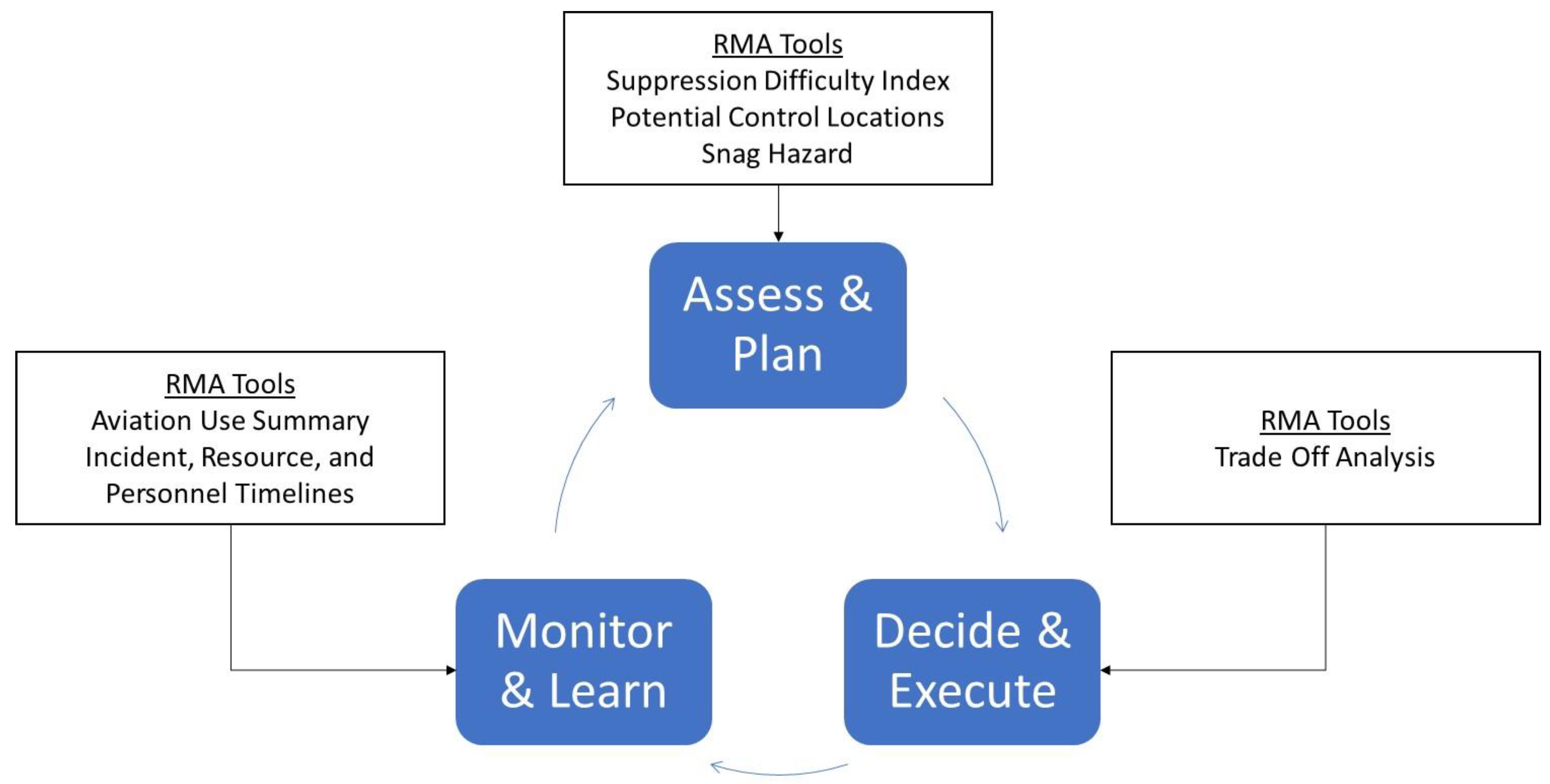
The structure and individual components of RMA fit into a standard risk management cycle that is generally consistent with other wildfire risk management processes (
Figure 2; see, for example, [
34,
47,
48]). Some RMA tools are highlighted and mapped according to the appropriate stage of the risk management cycle. “Assess and plan” involves the development of knowledge of the fire conditions, the impact to objectives, and alternative approaches to managing the event; “decide and act” require the selection of the preferred alternative and the implementation of the operational plan; “monitor and learn” determines if current actions are producing desirable results; if not, the cycle begins again.
In the Assess and Plan phase, RMA facilitates the co-production of an initial or updated risk assessment by the hosting unit and the IMT, based on response objectives and challenges. The assessment is informed by combining RMA tools with local knowledge about the area, to help facilitate situational awareness and guide the development of appropriate near-term actions and potential strategies. RMA tools, such as indices of suppression difficulty [
49] and the probability of control surfaces [
50], complement well-established fire behavior models that are frequently used within the large fire management environment, including Flammap, FARSITE, FSPro, and other tools delivered through the Wildland Fire Decision Support System [
51]. Incorporating analytical products with local knowledge facilitates improved reconnaissance, sizing up of the fire responder safety environment, assessment of the potential effectiveness of different strategies, locating and reinforcing the contingency lines, the weighing up of alternative approaches, and the potential short- and long-term outcomes of an incident. These tools can also support tactical decision-making during the management phase of the fire by rapidly identifying potential areas of high concern, as tactics and strategy evolve.
In the Decide and Execute phase, potential strategies are examined based on how well they meet established incident resource management objectives, the potential risk to fire responders, and the likelihood that they will be successful. This phase creates a transparent process for developing an alignment of AAs, IMTs, and other land management partners to discuss response options and to communicate objectives and strategies to a public information officer, to engage with the surrounding community.
In the Monitor and Learn phase, RMA tools provide information to AAs and IMTs to ensure that the incident strategy is progressing as intended or to identify if the incident strategy needs to be reevaluated. Monitoring tools facilitate discussions of ground and aerial suppression resource use and the effectiveness and expected fire duration, to inform ongoing and future suppression actions and resource needs. Stonesifer et al. [
19] present the Aviation Use Summary in more detail, and RMA timeline products can be accessed at the RMA dashboard [
52]. These tools facilitate the early recognition of the need to modify existing strategies or develop new ones and can support emerging performance measurement of wildfire suppression effectiveness, as described by Thompson et al. [
14,
34].
3.2. Implementation and Evolution
In 2017 and 2018, a request from the AA (usually the Forest Supervisor) was required in order to initiate RMA support. Typically, RMA teams were requested when an established fire appeared to be of high complexity and was likely to continue burning on the landscape for several weeks or longer. Once assistance was requested, the hosting AA provided a delegation of authority, outlining responsibilities for the RMA team and communicating with the assigned IMT regarding shared intentions. An RMA team would then travel to the site of the large fire, to gather intelligence and gain a better understanding of the local decision environment. A typical team composition included a line officer (the designated RMA team leader), operations specialist, wildfire analyst, and risk specialist.
In those first two years, the focus of the RMA program was to support the local AA, emphasizing the in-person engagement of an interdisciplinary team with the land management unit experiencing the event. The culmination of this engagement was typically the development of a trade-off analysis (TOA) that compared alternative strategies, based on incident resource objectives, firefighter exposure and risk, and the probability of success. The engagement brought together local leadership, key members of the IMT, and occasionally local public representatives, with the intent of achieving agreement and alignment around the strategy that best met the decision criteria. One primary finding of a review of RMA during that period by Schultz et al. [
13] was that “RMA increased line officers’ ability to communicate the rationale underlying their decisions more clearly and transparently to their colleagues and partners”.
However, Schultz et al. [
13] also noted that fully exploring strategic options through the TOA process was challenging due to several factors, including limited decision space once the fire was established, a need to establish strategic intent before the TOA could be completed, and concerns about external intervention in fire strategy determination. Additional user feedback included recommendations to introduce and utilize products and concepts in the pre-event planning phase and the need for increased training and experience with the assessment products and decision processes. Post-season reviews and findings identified the more timely delivery of products as a critical need. Specifically, the in-person delivery of a structured TOA did not align with the compressed timeline needed to establish an incident strategy.
Two additional primary issues became apparent with formally structuring a TOA. The first was the recognition that analytics, information, and expert knowledge were imbalanced across the risk to communities and landscapes and risk to responders. The probability of success factor was the least mature and the most reliant on expert judgment, which could be particularly problematic in cases where out-of-area IMTs were unfamiliar with the local landscape and conditions. Perhaps not surprisingly, the most valued analytics were those that spoke to responder safety and the probability of success. Second, the framing of alternatives was at times insufficient and overly simplistic to truly capture the complexity of the decision space. For example, some initial TOAs compared strategies that were defined as “direct” or “indirect” when, in practice, those are just tactics, and realistic incident strategies would likely employ both tactics but would vary in terms of the amount of direct relative to indirect line built.
With these issues in mind, the team initiated several changes to the RMA program, beginning with a definition of the primary problem to be addressed. We shifted the problem frame away from formalizing a TOA with simplistic alternatives and toward exploring opportunities for safe and effective control, enabling a discussion of tradeoffs associated with choices of where to engage, but in more meaningful terms. Additionally, we enhanced field training, reduced the delivery time of RMA assessment products through remote delivery, and increased the focus on linking with structured pre-season planning processes to identify potential wildfire operational delineations (PODs) [
18].
In 2019, RMA transitioned largely to a remote support model, focusing on delivering individual products to IMT members and hosting unit staff. Increased field experience with the RMA component products created an increased demand for these assessments to support locally developed incident strategies. By working remotely, RMA analysts were able to support more field requests by reducing travel time. RMA analysts communicated directly with the requesting individuals to tailor the required models to support the event.
During the 2020 fire season, the COVID-19 pandemic posed unique and unprecedented challenges for the fire management system but also created new opportunities to demonstrate and utilize remote decision support. RMA pre-staged the necessary data, recruited new analysts, and streamlined remote delivery processes to reduce response time and increase capacity to support the field. RMA also took advantage of the fact that many of the traditional analytical support resident on incident management teams would be delivered by regional analysts supporting multiple fires remotely, to avoid increasing the spread of COVID-19 within fire camps. The remote incident support was well-positioned to leverage the range of RMA analytics and to further customize products with a combination of observed fire behavior and fire–weather interactions, direct communication with multiple IMTs, and consultation with local observers.
3.3. Highlighted RMA Tools
RMA combines the expertise of agency administrators, fire managers, and research scientists with direct feedback from practitioners. This feedback allows the suite of products supplied through RMA to be constantly changing and improving and ensures that the specific products requested and/or developed for each incident can be highly customized to the specific needs of the decision-maker. Below, we provide brief descriptions of three of the currently most requested analytical tools that support RMA engagements: the suppression difficulty index (SDI), potential control locations (PCL), and the snag hazard map.
The SDI [
49] is a numerical rating of the relative difficulty in performing fire control work for each map pixel. In its simplest form, SDI is the ratio of suppression hazards to suppression opportunities. The numerator is an estimate of potential fire behavior, derived from modeled flame lengths and heat per unit area, and the denominator is an estimate of suppression opportunity derived from the sum of separate indices for accessibility (vehicular), mobility (on foot), and fire-line construction rates (both mechanical and manual) [
49]. Each sub-index is scaled from 1 to 10. The version used in the United States (tSDI) includes an additional adjustment penalizing inaccessible steep slopes, even in non-burnable fuel types. SDI scales are from 0 to 10 although, in practice, values greater than four are rare and fire responders consider values greater than one to be extremely difficult operating conditions. SDI has been used as a tactical response assessment tool on RMA incidents for four years, undergoing a series of adjustments and improvements based on feedback from incident management teams. Numerical breaks to classify extreme SDI conditions vary, based on regional differences in fuels, terrain, moisture, and accessibility. As an example, in wet coastal forests, fire responders considered values greater than 0.8 to be extreme, whereas in drier forests, the extreme classification is reserved for values greater than one. For fire support applications, SDI is supplied to the fire operations and planning section chief, fire analysts, and strategic planning positions in a range of digital formats to facilitate integration into the incident GIS, paper maps, and Google Earth overlays. Pre-positioned SDI scenarios can be used during the initial attack, as part of the fire sizing-up and tactical considerations for engagement. During an extended attack, updating SDI for current or forecast conditions can help with visualizing and communicating strategies and operational challenges or opportunities.
The PCL atlas [
53] is a predictive map of relative fire containment likelihood, developed from a 20-year dataset of past fire containment successes and failures. The model “learns” by distinguishing between those conditions inside a fire perimeter and conditions along the final fire perimeter. These conditions are characterized by a series of containment predictors, such as modeled fire spread rates, fuel type transitions, travel cost, SDI, and proximity to natural barriers (e.g., ridgelines, valley bottoms, waterbodies, recent burn scars), to create a landscape-specific model that can then be projected onto the current landscape condition. While the PCL atlas is not a map of actual containment probability (each fire occurs under a unique set of conditions), it provides a reasonable assessment of where suppression actions can leverage the combination of conditions that have successfully slowed or stopped fires in the past. For fire support, PCL is also supplied in a range of digital formats to a similar cadre of IMT personnel as the SDI; however, applications are generally more strategic than tactical, with a focus on planning containment strategies and when comparing tradeoffs among multiple containment options. PCL can also help to inform fire size and duration projections, depending on the relative density of control opportunities.
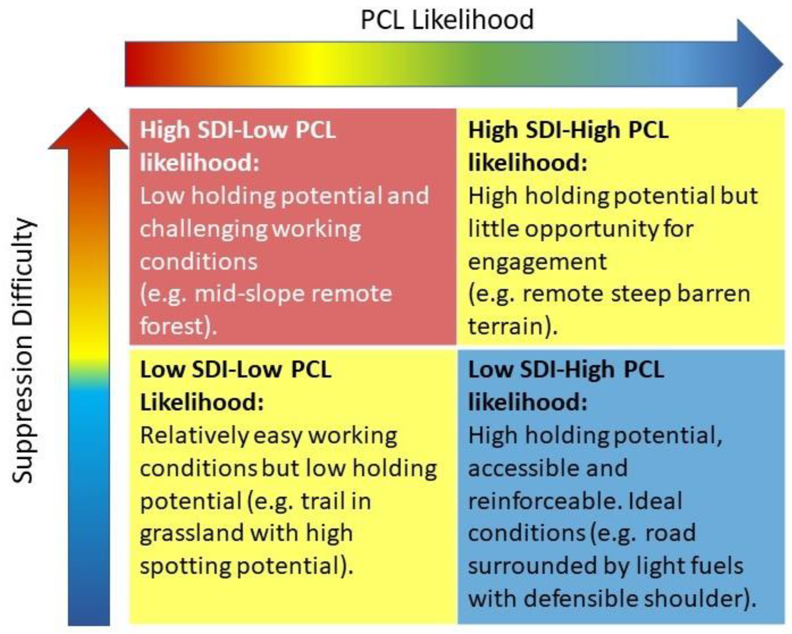
The PCL and SDI products provide a complementary assessment of suppression options. SDI’s reliance on fire behavior modeling makes it highly sensitive to changing weather conditions, making it better suited to assessing operational suppression challenges. PCL is more appropriate for strategic and long-term planning, due to the inclusion of environmental conditions that can slow or stop the fire spread even when suppression difficulty is high, or promote rapid spread even when the SDI is low. When used together, these tools provide a visual interpretation of the response challenges and opportunities that can be used to convene stakeholders and decision-makers. Internally, IMTs and agency administrators use these tools when considering tactical operations, and externally, maps of SDI and PCL are used in public meetings to help explain conditions on the ground and intended fire response actions (
Figure 3). Additionally, these tools have been used together with local expertise to develop networks of PODs (potential wildfire operational delineations) [
18,
53,
54,
55] for use in landscape-scale fire response planning and implementation.
Also critical to fire sizing-up and response assessment is an initial assessment of hazards to fire responders. The Snag Hazard map product is intended to show areas of relative hazard caused by dead, standing trees. The maps are compiled from the National TreeMap dataset [
56], primarily for use in large-scale modeling, and have not been field-verified. From the map of tree attributes, dead trees are extracted and summarized by median height and density per hectare. Data are classified using the relative hazard scale of Dunn et al. [
57] and displayed as a digital overlay for use by incident GIS staff and in Google Earth overlay format. In Region 5, the National TreeMap layers are combined with remote-sensing data collected from the eDaRT program [
58] to produce a cumulative tree mortality map from 2009–2020. The eDaRT-adjusted snag hazard map is similarly classified as per Dunn et al. (2019) [
7] and represents a “tuned” version of the National TreeMap snag hazard product that is adjusted to account for remotely observed mortality events.
RMA analytics and tools hosted on the RMA dashboard [
52] include interactive maps and incident-specific information summaries, presenting the individual products that allow fire managers and specialists to visualize the risks and opportunities presented by a fire on the landscape of interest. The dashboard is an open site that can be accessed by federal, state, local, and private partners. Analytical tools hosted on the site include a combination of customized real-time incident support products and more standardize pre-positioned tools, available prior to fire ignition and typically at broader regional or national scales. The interactive RMA dashboard is continuously updated and is available online [
52].
4. RMA Fire Support Application Case Studies
Here we review four specific applications on large wildland fire incidents, to demonstrate the evolution of RMA engagement over time, the flexibility of the RMA framework to adapt fire analytics, and the risk management decision cycle to support the needs of individual incidents. A fifth example is provided by Stonesifer et al. [
19] in this issue on the application of the Aviation Use Summary. Direct engagement, either remotely or in person, promotes the introduction of and familiarity with custom analytics, engagement across disciplines, and an improved environment for structured decision-making. These examples demonstrate the range of issues explored with RMA, how RMA tools informed decisions, and the geographic diversity of RMA engagement.
4.1. Crescent Mountain Fire, Washington State, USA
For the first two years of the RMA program, analysts invested a significant amount of time in one-on-one engagements with IMTs to introduce new analytical tools and to build a rapport between fire practitioners and fire scientists, to integrate science more seamlessly into decision-making. The following example details one such engagement where an out-of-area team was transitioning onto a high-risk fire and needed a rapid sizing-up and assessment for the fire environment before committing their resources to any specific containment objectives.
On 7 August 2018, a Southern Area T1 IMT took over the Crescent Mountain Fire on the Okanogan-Wenatchee National Forest in Washington State. Three years previously, the Twisp River Fire killed three firefighters and injured four others in a burnover entrapment, only a few miles to the east. RMA personnel had already developed an initial suite of analytical tools for a nearby incident and supplied initial SDI, PCL, and evacuation route analytics as part of the morning team in-briefing.
This was the first time that the IMT had seen RMA analytics, so the operations chief reached out directly to RMA analysts to learn more about the products and their interpretation. When comparing how the fire was spreading with wind-driven mid-slope runs and stopping at higher elevations, the operations chief found that the PCL and, especially, the SDI maps supported the “gut” feeling of experienced operations personnel about where they were likely to have the highest probability of success in keeping the fire as small as possible, while mitigating the risk to fire responders. Operations personnel developed a plan to contain the fire as it advanced to the southeast, using the national forest trail 408, which was the first opportunity to engage the fire with a PCL holding likelihood greater than 0.25 (
Figure 4). The team used SDI and PCL maps in meetings with agency administrators and with the public, to help convey the containment strategy. Two days later, the prepped line was challenged by the fire and was held for eight days while it continued to smolder. A high-wind event on the afternoon of 17 August caused the fire to spot across the valley at mid-slope, jumping the reinforced line and allowing it to progress through a matrix of steep terrain, following the pattern predicted by SDI and PCL, until it was finally contained at a dense network of roads on 9 September 2018.
4.2. Ferguson Fire, California, USA
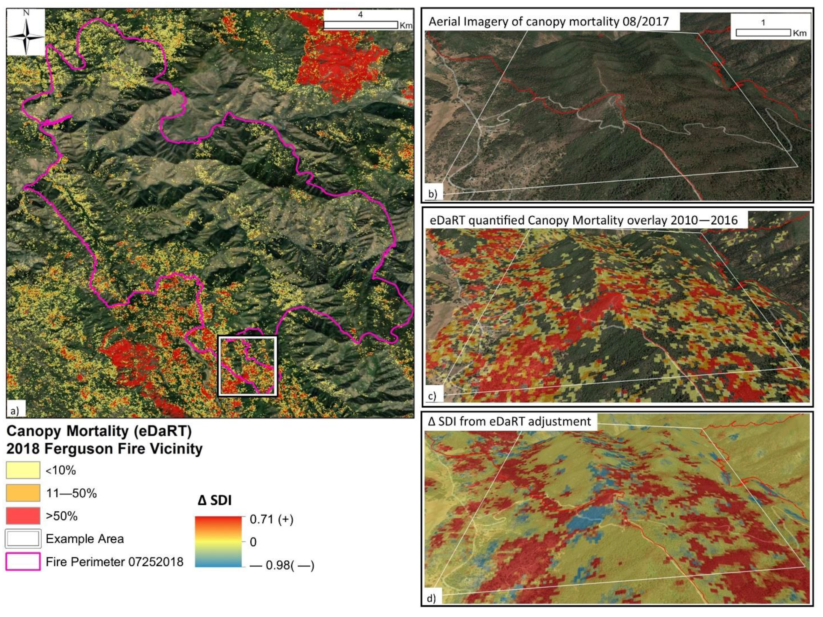
Distribution of RMA analytics to local land managers and their partners created unique opportunities to incorporate local knowledge and data products to produce custom tools where better data were available. In the following example, an information gap identified by incident managers was addressed by creating a research partnership between the RMA risk scientists and local environmental scientists to produce a high-resolution map of snag risk to fire responders that was then further tuned with field observations to integrate with other RMA analytics.
On 20 July 2018, RMA engaged with the Incident management team and leadership from the Sierra National Forest, concerning the Ferguson Fire in the Sierra Nevada Mountains of California. Located approximately 24 km (15 mi) due east of the west entrance to Yosemite National Park, and 6 km (3.75 mi) south of the 2013 Rim Fire footprint, the Ferguson Fire was burning in heavy timber on rugged terrain, with a high snag load caused by significant bark beetle outbreaks from 2013 to 2017. Along with initial requests for the standard suite of RMA analytics, the Long-Term Analyst (LTAN) requested any available information on snag mapping for the area. At the time, the only national database of insect disturbance and potential snag hazard was the insect and disease survey (IDS) mapping program [
59]. For this landscape, IDS tree mortality polygons (2014–2017) covered almost the entire forest and surrounding area but, without information about the severity of mortality, these did not prove useful for assessing firefighter exposure concerns on the ground.
The Regional Fire Planner connected the RMA analysts with scientists at the Region Five Remote Sensing Laboratory (RSL) who were prototyping a new experimental canopy mortality mapping system, known as the “Ecosystem Disturbance and Recovery Tracker” (eDaRT) [
59]. The eDaRT system was designed to detect, quantify, and track forest canopy mortality and eventual regrowth over time, making it an ideal candidate for incident-level snag hazard mapping. Initial eDaRT overlays, showing cumulative canopy mortality from 2010 to 2016, were used to quantify areas of snag hazard concern (> 10% recent overstory mortality) at the 30-meter pixel scale, allowing for a more refined assessment of the elevated risk to firefighters (
Figure 5).
On 25 July 2018, an analyst from the R5 RSL observed that while smoke-shading was suppressing the fire spread in healthy forest, the surface fire was actively spreading in snag patches where surface fuels were augmented with “branch fuels” from the dead and dying canopy, promoting convective spread upslope, even against prevailing winds. To capture these observed dynamics, RMA analysts modified the SDI to account for upslope winds and increased surface fuel loading only in the snag patches identified by eDaRT (
Figure 5). These custom snag hazard and modified SDI products provided a more accurate portrayal of the increased hazards to fire responders from recent beetle kill and were used to communicate the need for indirect tactics to protect fire responder safety until the fire moved to more defensible roads and open country. This initial snag-mapping effort led to additional cooperation between RMA and the R5 RSL over the 2020 fire season, to produce an eDaRT-adjusted snag hazard map that accounts for pre-disturbance forest height and tree density. This new product combined the National TreeMap [
56] with the new eDaRT-based mortality magnitude index (MMI), the snag hazard rating system [
57], and the landscape change monitoring system (LCMS) disturbance rate tracker [
58] to produce an annual overlay of snag hazard for the forested lands of California.
This example illustrates the value of having access to flexible skillsets across a range of disciplines, to adapt and combine datasets to significantly improve the decision-making environment for fire managers. This is one of many examples of on-the-fly solutions developed through partnerships between national- and local-scale scientists and managers.
4.3. Pine Gulch Fire, Colorado, USA
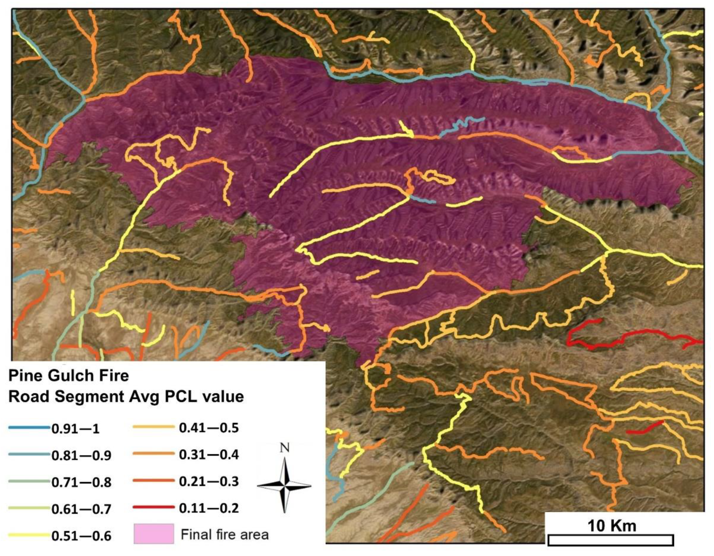
The 2020 fire season and COVID-19 pandemic posed a unique set of challenges for incident management teams but also created new opportunities to increase reliance on remotely located resources, such as fire behavior analysts (FBANs). Remote FBANs supported incident teams on multiple large wildfires simultaneously, essentially functioning as area command support instead of incident-level resources. This unique access to support multiple incidents, combined with the previous three years of experience with RMA products, proved to be fertile ground for innovation among the fire analyst corps. Analysts independently developed methods to assess relative holding potential for a range of existing road networks, using the reanalysis of RMA PCL maps and tools to assess the relative “costs” of improving road and trail networks for fire containment, based on SDI maps. As credentialed fire professionals, assigned to support IMTs, these analysts had access to real-time feedback from field operations. The credibility of their own fire careers uniquely positioned them to track if or how analytics were used to support key decisions regarding incidents.
An early example of this new functionality came from the Pine Gulch Fire, ignited by lightning on 31 July 2020, north of Grand Junction, Colorado. The fire grew rapidly over the next ten days and, at a size of just under 15,800 ha (39,100 acres), RMA support was requested on 11 August. Rapid fire spread posed unique challenges for assessing the holding potential under consistent high winds and drier than average conditions. In 2020, RMA produced its first standardized regional-scale SDI and PCL products depicting 90th percentile fire weather conditions, to aid with pre-positioning data for rapid assessment and decision support. These products were supplied to the FBAN, who had used incident-specific fire weather versions of both products for previous fire support and in pre-season fire planning on his own forest. The FBAN reached out to RMA analysts to inquire about the fire weather assumptions of the new standardized SDI and PCL products and was cautioned about the “relative” nature of control likelihood under highly variable winds and fuel moistures. To address the mismatch between observed and simulated fire behavior, the LTAN ran an analysis of average PCL values for a 120-meter buffered area along a segmented network of all roads in the three counties affected by the fire. Segments were labeled according to the average PCL value for the buffered segment area, and observations of effective road holding locations were used to establish the effective PCL threshold needed for a road to serve as a functional containment location. Buffering the road corridors helped to differentiate those locations where the roads themselves were the only viable control features from those areas where a combination of road location, fuel transitions, accessibility, and fuel type and fire behavior transitions improved the potential holding capacity. The method proved successful for selecting the eventual road networks that held on the 56,250-ha (139,000-acre) Pine Gulch Fire (
Figure 6) and, two months later, on the 71,580-ha (176,878-acre) Mullen Fire.
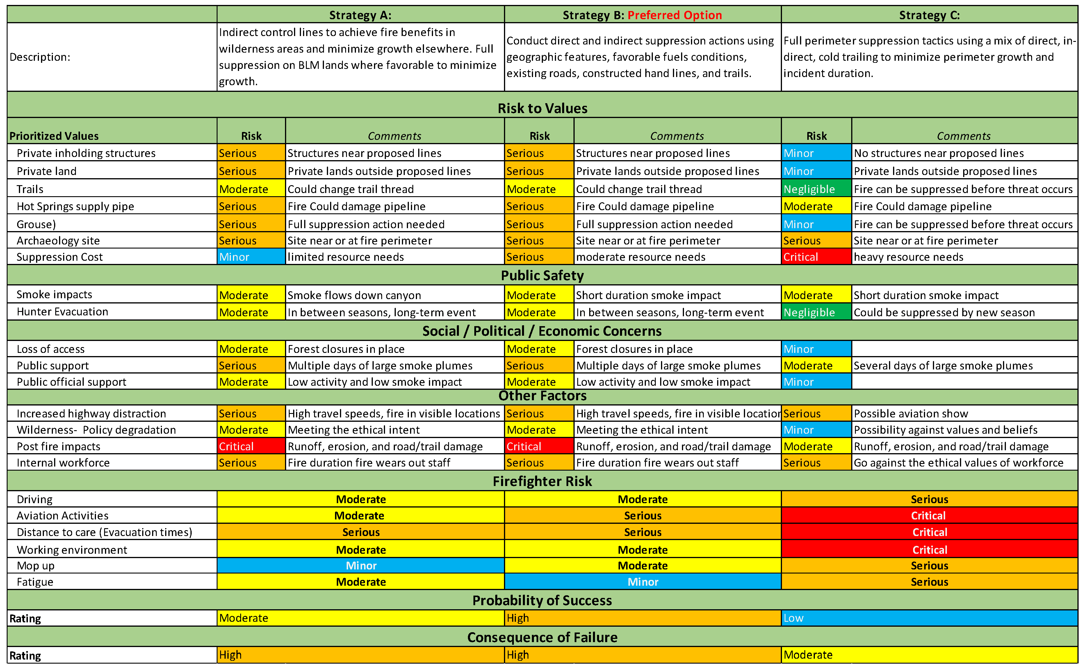
4.4. Decker Fire, Colorado, USA
Although RMA has largely transitioned away from utilizing trade-off analysis (TOA) as the focus of their engagement with the field, under certain conditions, it can be a highly effective tool to inform large fire strategic decisions. As noted earlier, assuring TOAs are developed while there is still significant strategic decision space, with strong internal support by AAs and IMTs (13), are both significant challenges and critical needs. These conditions coalesced to allow the TOA process to have a significant influence on the management strategy of the Decker Fire.
The Decker Fire started on September 8 2019 from a lightning strike in the Sangre de Cristo Wilderness, on the Rio Grande National Forest in southern Colorado. The fire ignited in rugged, remote country, with limited immediate values at risk. The AAs on the Forest, who had been exposed to RMA through previous fire engagements, requested that RMA facilitate the development of a TOA to identify strategic options for the management of the fire. The initial TOA was conducted on 9 September and was re-run on 15 September and 2 October, after the fire made significant wind-driven runs.
Figure 7 provides an edited version of the Decker Fire TOA from 2 October, comparing three alternative strategies demonstrating the key components of the TOA. Specific considerations included the risk to developed and natural resource values, risk to public safety, social/political/economic concerns, risk to firefighters, the probability of strategy success, and the consequence of failure. The TOA process utilized RMA analytics, including SDI, PCL, and snag hazard to inform the initial decision on 9 September to not engage in direct suppression actions since the protection of values at risk did not justify the risk to firefighters and the estimated low probability of success, but it did support indirect suppression to modify fire spread on some portions of the fire. As the fire progressed, and the risk of negative fire impacts increased, the TOA supported additional indirect fire actions while still recognizing the value of avoiding direct actions on the fire line. The fire burned a total of 3626 ha, with fire progression stopped on October 24 due to a major snow event. Following the conclusion of the fire, Schultz et al. [
60] conducted an independent review of the management of the Decker Fire by interviewing key participants, to better understand their perceptions of the TOA process. Respondents emphasized the value of the TOA in structuring conversations regarding objectives across ownerships and achieving agreement, thoughtful consideration of the risk to firefighters, and providing documentation of the decision process.
5. Discussion
RMA has benefited from and supported the maturing of risk management within the US federal wildfire program, through leadership engagement, improved assessment and planning, and enhanced capacity and training that is consistent with guidance provided by Thompson et al. [
18]. Although the outward focus of the RMA program has been on the production of risk assessments and other decision support tools, it is important to note the role of leadership in articulating the intent of the program and supporting it through funding and the direct participation of several national-level leaders in a variety of RMA functions. Additionally, annual after-action reviews have provided important opportunities for the RMA team to summarize existing barriers and emerging challenges and share those issues with senior agency leadership. Recognition of the importance of RMA to the Agency’s strategic goals was highlighted on page 1 of the USDA’s Forest Service 2021 Budget Justification [
61]: “The Risk Management Assistance framework provides for a holistic and integrated approach to incident response and decision-making beginning in the planning cycle. This new approach, developed in concert with State, local, and county partners to increase the decision space for fire managers and to provide line officers with more opportunity to influence incident outcomes.”
The application of RMA analytics varies greatly based on the user of the information, the fire environment, and the needs and complexities of the incident. Analytics are being used in all phases of the life cycle of the fire incident, including strategic decision development and documentation, public meetings, incident briefings, long-term assessment, situational awareness, tracking, and monitoring and post-fire reviews. With the transition to pre-staged remote delivery, the tools are often used by out-of-area incident management teams for accelerated situational awareness and sizing-up. One Type 1 Incident Commander described it as follows: “Whenever I know I’m going to a fire I order up about 5 or 6 analytics right away even before I get to a fire just because I know their value”.
RMA has accelerated the adoption of new wildfire analytics, using a structured risk management approach to support strategic planning and response for a majority of the most complex wildfire events in the US over the last several years. RMA has both benefited from and helped accelerate the application of pre-event planning. Several of the core RMA products, most prominently SDI and PCL, are key components of a major wildfire suppression planning process known as PODs [
48,
53,
54,
55]. The alignment of the PODs process with RMA creates a positive feedback loop, where those who are exposed to the PODs process will be more likely to request and utilize RMA assistance while on fire assignments, and those exposed to RMA when participating in incidents will bring that knowledge back to their home unit, spurring adoption of the PODs planning process [
62]. Thus, it appears that there are now a significant number of IMT members, local unit leaders, and fire analysts who have some level of experience in the application of RMA products and our approach to structured decision-making. This represents a major shift in how the Agency prepares for and responds to fire and redeems its risk management responsibilities, as articulated in the Red Book and elsewhere.
During the first two years of RMA, analysts worked directly with field users to tailor models to fit the individual fire conditions. This helped accelerate the adoption of the models and helped analysts improve their models but it also posed a challenge. If product users are looking to analysts to modify their assessments until the output matches their expectations, the value of these models is greatly diminished. Those concerns have been reduced since, currently, most RMA product delivery occurs through standard products downloaded from the RMA dashboard.
RMA experiences align with many of the findings and recommendations from [
63], including the need to increase analytical capacity and to clearly define the question that the decision support system is meant to address, the value of building relationships and sustaining communication over time, of validating and testing products with end-users, and of providing education and training to end-users. The RMA team has recognized that the work to improve complex strategic decision-making is both technical (assessment and planning) as well as social (communication and coordination). RMA had provided scientists with opportunities to test new tools, engage with field operators and managers to better understand the decision environment, and explore areas where future research will have the highest impact. Managers have benefited from having critical information and structured processes available at the time when strategic decisions need to be made, along with improved situational awareness for the initial phases of large fire management. Furthermore, RMA has helped senior leadership understand the complexities, challenges, and opportunities to improve high-impact strategic decisions in wildfire management.


