Article

Green Infrastructure—Countering Ecosystem Fragmentation: Case Study of a Municipality in the Carpathian Foothills

Department of Spatial Planning, Urban and Rural Design, Faculty of Architecture, Cracow University of Technology, 31-155 Kraków, Poland
*
Author to whom correspondence should be addressed.
Forests 2021, 12(1), 78; https://doi.org/10.3390/f12010078
Submission received: 14 December 2020 / Revised: 7 January 2021 / Accepted: 8 January 2021 / Published: 12 January 2021
(This article belongs to the Section Forest Ecology and Management)

Abstract

:
This paper discusses green infrastructure, which can be considered a useful tool in the process of ensuring the sustainable development of rural structures in the polish Carpathian region. It allows for achieving a better quality of the environment of human life and healthy wildlife linkages. The element that supports defining information about the existing state of green infrastructure and its resources is the green infrastructure fragmentation coefficient based on edge effect calculations, which is the relation between the edge of the patch (circumference) to its surface area. With the use of model analysis of green infrastructure, it is possible to implement the provisions of the Carpathian Convention and coordinate planning documents that facilitate the sustainable development of spatial structures. Our study on the state of green infrastructure in rural areas of the Polish Carpathian Mountains is a source of knowledge about the quality of this area, its natural environment and fragmentation. Determining the territory’s green infrastructure fragmentation coefficient provides an opportunity for higher-precision studies and the detection of threats and integration of GI fragments and addressing proper solutions in conflict areas.

1. Introduction

The necessity for a broad outlook on the development and protection of the assets of the Carpathians has been recognized relatively recently. The European Union strategy on green infrastructure has become a basis for taking appropriate action. The European Commission adopted a new strategy on 6 May 2013, which is intended to encourage the improvement of green infrastructure quality and its broader inclusion in spatial planning in the entire region of the European Union [1]. This has happened due to anthropogenic pressure and the associated construction of technical infrastructure, combined with urbanization, and has led to a degradation of valuable ecosystems and their division, which negatively impacts habitats and resident species and limits spatial and functional coherence of the landscape. Defining priorities so as to restore and support the use of green infrastructure is particularly significant in areas with distinctive environmental conditions and is highlighted in the literature [2,3].
In southern Poland, there are numerous cities and municipalities whose size and amount of green infrastructure areas appear to be large. They can be divided into several categories based on the size of the municipality’s territory and its population. Large municipalities, with a high share of green areas, include the municipalities of the Subcarpathian and Lesser Poland voivodeships. In Lesser Poland, areas with the highest share of green areas are those of the Tatrzański, Suski, Nowosądecki and Gorlicki districts. Municipalities with a clearly lower amount of green and open areas when compared to the rest of the region include Kłaj, Trzciana and Łapanów.
In this paper, we present a case study of a Polish municipality located in the Carpathian Mountains region—Łapanów. After studying its spatial structure in terms of open and developed areas, we analyzed its greenery structure and shape (fragmentation). Among the methods of determining the condition of a greenery structure’s condition are pattern indicators, which is based on applying spatial filters to land cover maps—the indicators are calculated based on the frequency of the presence of types of land cover and tendencies of a given type of land cover in terms of spatial autocorrelation [4]. However, this method may prove ineffective when used on a smaller scale due to the complexity and detailed nature of the process and exceedingly detailed results, whose practical application in a smaller administrative unit such as a municipality could pose a problem. It would require professional software and a staff trained to conduct such tests and then analyze them. In this respect, the fragmentation coefficient calculation method seems to be a more universal tool that can be introduced without large financial outlays. For this reason, we performed the analysis of green infrastructure fragmentation on the territory of the municipality of Łapanów by calculating indicators for the edge effect [5]. Our study was based on the hypothesis that continuity of structure shall have a positive impact on the presence of selected species [6]. Our study assumes that the amount of green infrastructure does not fully correlate with the possibility of its application in the presence of its lack of continuity, which can be ensured by gradual densification of existing greenery fragments with new patches.

2. Materials and Methods

To study actual ecosystem continuity and coherence, we initially selected the above three municipalities for analysis (Figure 1). The municipalities have a rural character and do not have cities or towns within their limits. They have established agricultural traditions and their space has a well-preserved rural character without heavy industry. All of the three municipalities are within the range of the recreational zone utilized by residents of the Krakow agglomeration. This location results in significant anthropic pressure being exerted on open spaces and can constitute a potential threat to the GI network. All three municipalities are also located near major migration trails in the form of ecological corridors for this region (Figure 1).
Of the three selected municipalities, we chose Łapanów as a reference case due to the legibility of its greenery structures and the longest section of the Lesser Poland Ecological Corridor that runs through it. It was found to be a representative case of a disappearing rural landscape based on small farms, which is distinct for southern Poland and contributes to its mosaic-like character and high degree of biodiversity.

2.1. Beginnings of Green Infrastructure

Green infrastructure refers to global problems that particularly refer to regions subjected to intense spatial development, whether urban or rural. It is a key strategy as a part of the European landscape and environmental policy, intended to reconnect major wildlife areas. It is also a concept of improving the capacity of ecosystems to self-regenerate. Green infrastructure is discussed in the literature often in reference to urbanized areas such as urban and suburban greenery systems [7,8], but is also common in rural areas. It is not a new term, as it has been in use since the 1990s and was first used in the United States [9]. On the other hand, the concept, which states that ecosystems should also be treated as infrastructure, has existed since the 1980s [10].
Attention to green infrastructure has already been visible around 150 years ago in the linking of green spaces and parks to the benefit of their users and linking wildlife areas to preserve biodiversity and prevent habitat fragmentation. This idea was first put forth by Frederick Law Olmsted, who noted that a single and well-designed park shall not provide people with as much beneficial natural influence like numerous parks that would be linked with each other and encircle housing areas [11]. This is how the idea of greenery as a system first appeared. During this period, biologists were also aware of the fact that protecting habitats from fragmentation is considered the best method of preventing biodiversity loss. In a 1999 report of the US President’s Council on Sustainable Development, green infrastructure was described [12] as one of five elements of a strategy intended to ensure a holistic approach to the problem of sustainable community development. The document stated that the green infrastructure strategy is to understand, recognize and exert positive impact on ecological and economic functions provided by natural systems. The element of ecosystem services and their significance to sustainable development has thus been clearly recognized and highlighted.
Throughout this entire period, numerous institutions have also become involved in improving the condition of ecosystems, supporting measures in support of green infrastructure. Table below (Table 1) presents initiatives for green infrastructure and the signatories of these agreements. Interest in initiatives from larger companies signals awareness of the problem and the need to act.
In 1967, the Capital District Regional Planning Commission (CDRPC) was established in the United States, as an organization that constitutes a regional and resource planning center. Its duties include objective analysis of data, trends, opportunities, threats ad challenges that are significant to regional development. The organization has formulated a “GI toolset” that is analogous to European proposals, whose main goal is to monitor dependencies between gray and green infrastructure.
The main practices concerning the protection of green infrastructure were listed by the CDRPC as the following:
  • Tree planting;
  • Decoupling non-permeable areas;
  • Building green roofs;
  • Using semipermeable porous surfaces;
  • Creating infiltration pools; chambers and ditches;
  • Creating plant baths
  • Practicing bioretention;
  • Use of rain gardens.
As a part of introducing green structures and initiating measures associated with it, the European Commission has put in place the EU Strategy on green infrastructure and the EU 2020 strategy on biodiversity. All of its goals require ecosystem functions to be maintained and reinforced by creating green infrastructure and recreating at least 15% of degraded ecosystems [1]. The Commission’s conclusions concerning the Cohesion Fund and the European Regional Development Fund [13,14] define green infrastructure as a development priority and state that is an element that significantly contributes to regional policy and Europe’s sustainable economic development. There is also a clear connection between the subject of green infrastructure and the implementation of the European Union’s climate policy, as well as the United Nations Framework Convention on Climate Change [15,16].
In the Communication from the Commission to the European Parliament, the Council, the European Economic and Social Committee and the Committee of the Regions green infrastructure (GI)—Enhancing Europe’s Natural Capital [1], the contribution of green infrastructure to EU policy was discussed from the standpoint of:
  • Natural and cultural heritage that constitutes a part of the EU’s capital and identity;
  • Utilizing soil potential instead of air-conditioning—financial savings;
  • Alleviating climate change consequences and adaptation to them;
  • Building resilience and improving defensive mechanisms against flooding;
  • Sustainable agricultural land management;
  • Prevention of soil erosion;
  • Harmonizing human activities with the natural environment.
This document is a basis and direction for further action and engaging with the subject matter on the local scale.

2.2. What Is Green Infrastructure Now?

In the process of considerable urbanization, a change in the model of space has taken place—From an urban structure surrounded by greenery, the model changed into elements of greenery surrounded by an urban structure. The anthropogenic area and its buildings were initially surrounded by many greenery. This trend has been reversed, and now it is only a small amount of green areas that are surrounded by buildings and anthropogenic areas. Due to changes such as uncontrolled urban sprawl or increasing disproportions between the natural and anthropogenic environment—which are seen as unfavorable from an environmental standpoint—a need to connect and integrate green areas and surface waters with their surrounding ecosystems—so-called Blue-green infrastructure [17]. Benedict (2006) defined green infrastructure as a wide array of natural and recreated domestic ecosystems and landscape elements [18,19].
When referring to the definition adopted by the European Commission [1], green infrastructure is a strategically planned network of natural and seminatural areas with other environmental features designed and managed to deliver a wide range of ecosystem services. It incorporates green spaces (or blue if aquatic ecosystems are concerned) and other physical features in terrestrial (including coastal) and marine areas. On land, GI is present in rural and urban settings. According to this definition, green infrastructure comprises all ecosystems or their fragments, irrespective of scale. Green infrastructure can also be discussed on the global and regional scale, yet this paper focuses on the local perspective on green infrastructure.
The subject of GI has been discussed in studies and academic reports numerous times [20,21,22], yet it should be noted that it typically focuses on urban municipalities and heavily urbanized areas. It is not analyzed as often in rural municipalities as no problems with green area integrity are signalized there. Green infrastructure elements in rural environments are typically in much better condition than in urban areas, yet not protecting them appears to be an issue. This results in a lack of planning and the possibility of directing the trajectory of anthropogenic structure growth.

2.3. Green Infrastructure—Significance of Protecting the Natural Environment in the Carpathian Mountains

The Carpathian Mountains are a major European mountain chain, less than 10% of which is located in Polish territory. The mountain chain features many highly valuable natural areas, which are often transformed to a very small degree. To protect the correct functioning of the natural environment of the Carpathian Mountains, which is located within the administrative borders of seven countries, and to also preserve the resources of this environment for future generations, it is necessary to integrate measures with the intent to better shape space. This is especially needed in a situation when state legislation on spatial planning does not require sufficient conservation of the resilience of key natural processes in the mountains. Spatial planning should facilitate the protection of the proper functioning of the natural environment in the mountains (as highlighted in Article 5 of the Carpathian Convention). Framework Convention on the Protection and Sustainable Development of the Carpathians [23] is an international agreement concerning the relevant mountain region and is modeled after its predecessor, the Alpine Convention from 1991. The convention does not put specific measures in place, instead expressing the will of its signatories to cooperate towards achieving the general goals of the convention and defines political goals, rules of cooperation and the obligations of parties to the convention. Implementing the Carpathian Convention requires ratifying the document in every state, defining detailed obligations arising from each of the issues that it concerns. Parties to the Carpathian Convention have pledged to cooperate towards: protecting the biological and landscape diversity of the Carpathian Mountains and their sustainable use, coordination in spatial planning, ensuring integrated and sustainable management of water resources and river areas, promoting sustainable agriculture and forestry, developing sustainable transport and infrastructure, developing sustainable tourism, promoting environmentally safe industrial and energy production technologies, preserving and promoting cultural heritage and folklore, assessing and monitoring the state of the environment and raising awareness and conducting educational efforts among society about the Carpathian Mountains [24]. The objective of the convention is the development of the area and make its development sustainable while accounting for quality of life, enhancing the local economy and local communities and preserve wildlife, landscape and cultural heritage assets of the Carpathian Mountains.

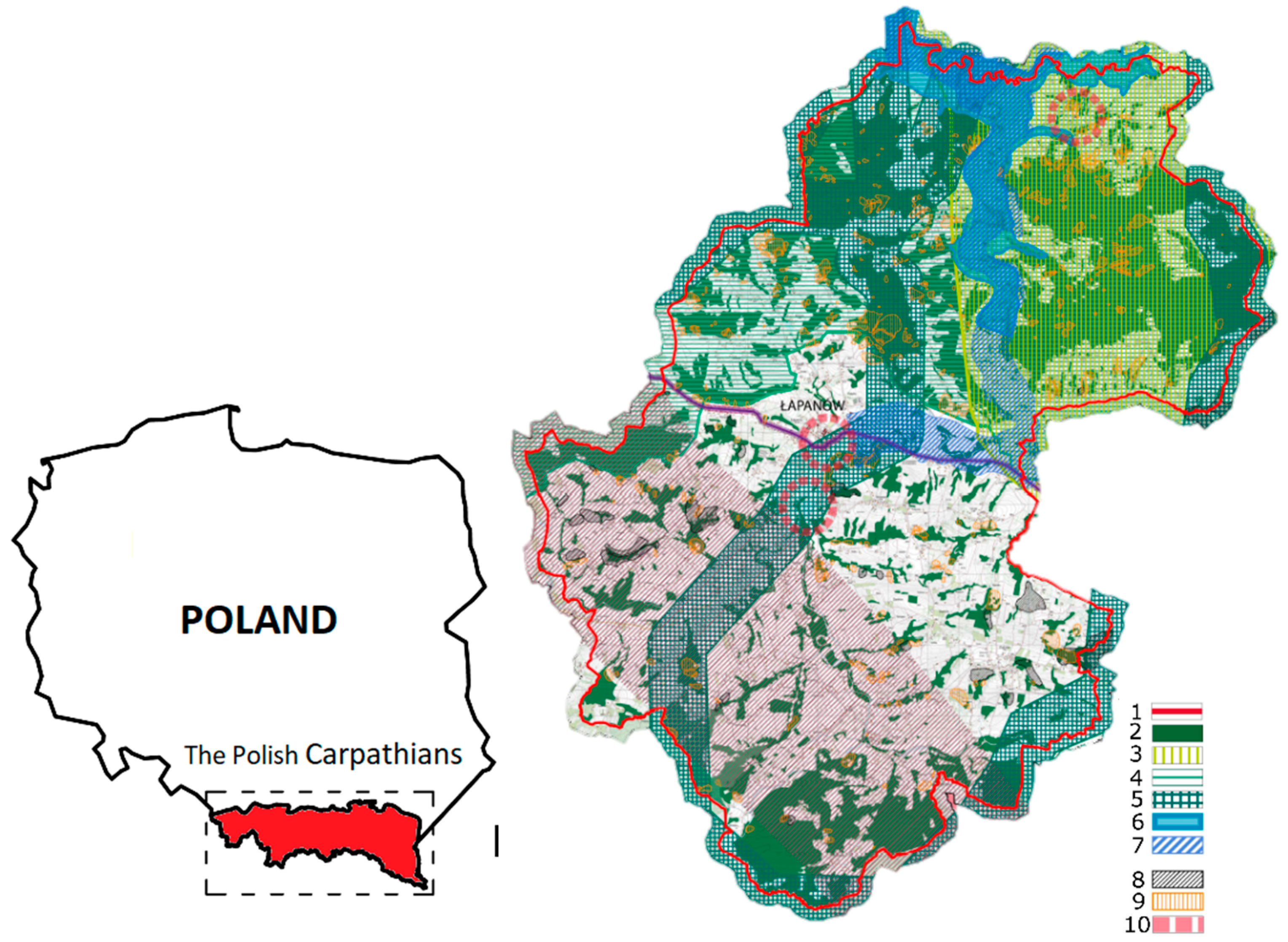
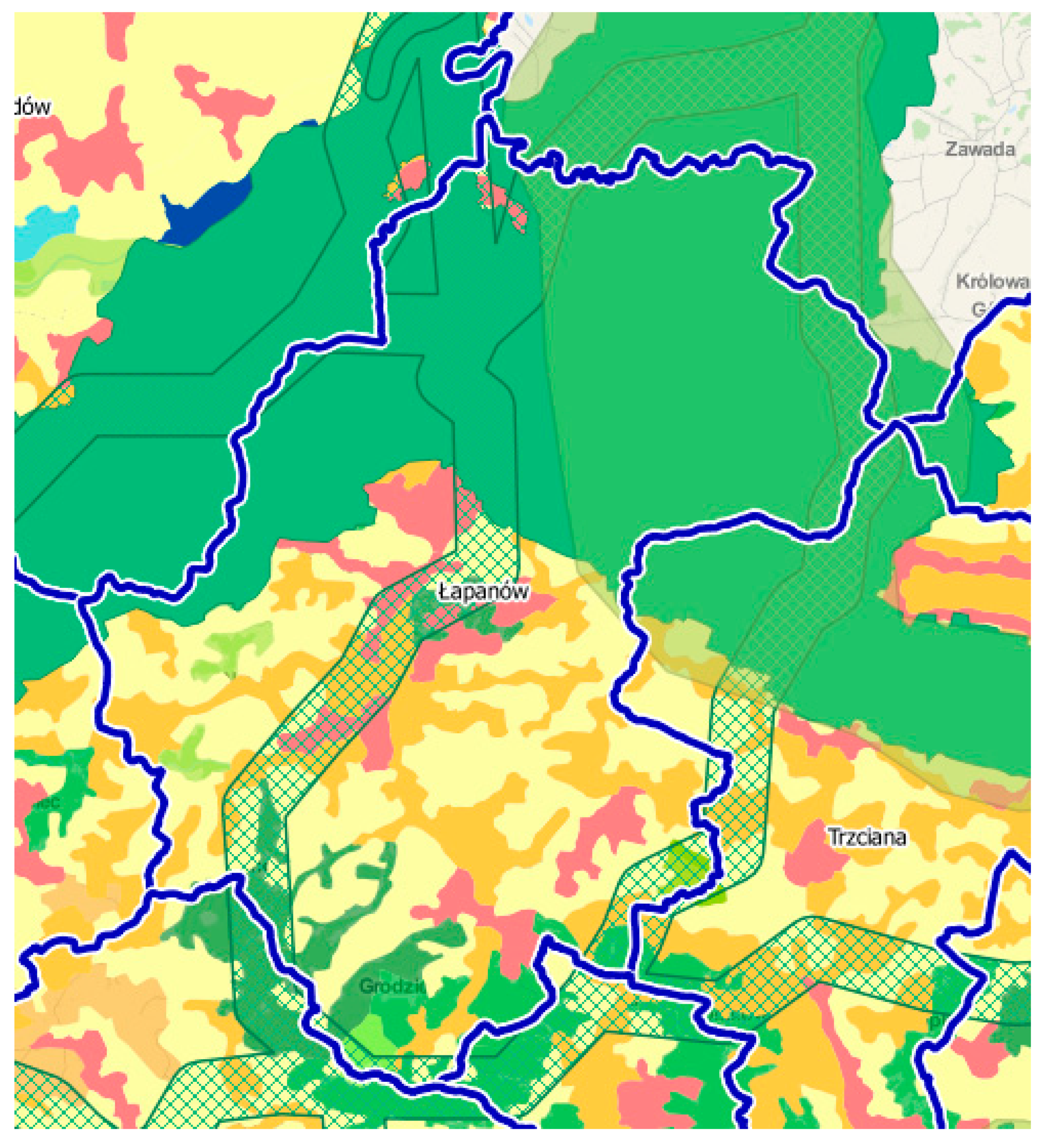
2.4. Łapanów: Case Study-Cultural and Ecological Heritage

The structure of the municipality’s urbanized areas is based on historically shaped settlement layouts. The heart of the municipality is the village of Łapanów (Figure 2) which has a central, orthogonal market square. The development here shows signs of sprawl, and is concentrated around roads, similarly as in the rest of Poland. Open areas predominate in the spatial structure. The central part of the municipality is more developed, with single-family and agricultural development, while the peripheries of the municipality, due to the shape, cover and morphology of the terrain, are less urbanized. Łapanów’s landscape has largely been shaped by mountain chains.
The territory of the Wiśnicz Foothills Protected Landscape Region, in which the municipality of Łapanów is located, is valuable in terms of its flora and fauna due to being a region of the point of contact and mixing of mountainous and lowland species, as well as due to the high diversity of ecological niches which display a highly natural state. Łapanów’s landscape, due to the considerable amount of small hills, allows for distant views. The panoramas that can be viewed from them are formed by multiplane curtains. The sprawling development has not yet managed to adversely affect the most interesting views and priority panoramas. The landscape has numerous components, greenery being key here, with patches of trees, forests and fields, meadows and non-landscaped areas. Elements of green infrastructure, together with anthropogenic, i.e., man-made elements, create the background in which we are present as residents and visitors or tourists. The spatial relationships between cultural and environmental elements qualify the area of the municipality as an agricultural landscape that has no industrial or urban characteristics.

2.5. Natural Capital Assessment: Comparative Table with Municipalities of the Carpathian Foothills

Łapanów is a seasonal recreational destination for residents of the Krakow agglomeration. This is why municipalities of a similar character and located in the Polish Carpathian Foothills are a good plane of comparison. In table below (Table 2) we chose 7 municipalities to compare in terms of their tourist facilities, cultural and natural heritage. Foothill-type municipalities form a considerable part of the Polish section of the Carpathians. They are thus more susceptible to urbanization pressure. Areas with unbalanced greenery structures, which also perform recreational functions, have become the subject of comparison. The first indicator was the isochrone (equidistant) of access to the recreational area of no more than 35 km, which is around 60 min using vehicular transport. Other indicators included non-wildlife assets and resources, which can increase tourist pressure on agricultural areas. The final element taken into consideration were significant and clearly defined greenery structures within municipal territory, which included forests, waters (rivers, lakes, recreational water bodies) and ecological corridors. The most important element of the verification was whether or not the agricultural landscape in the municipalities under study was under threat. For this reason, we compared three municipalities: Kłaj, Trzciana and Łapanów and presented the results in Table 2.
In light of the comparison, the municipality of Łapanów was selected for the final analysis, which is a representative case of a surviving rural landscape.

2.6. Analysis of Planning Documents in Terms of green infrastructure Provisions

To assess whether countering green infrastructure fragmentation is reflected local law, we analyzed planning documents of the municipality of Łapanów in terms of protective provisions applying to the natural environment [25]. The results of this analysis are shown in Table 3.
The listing above indicates that although local plan provisions do reference protecting green infrastructure elements, there is a lack of explicit provisions that would prevent greenery fragmentation. Provisions of local law do not clearly define how to refer to them and leave too much freedom of interpretation. This suggests the inability to control the condition of the green infrastructure network and is a serious threat in the case of areas with rapid rural development. Adding provisions to protect the areas of green infrastructure is necessary to manage rural development in a sustainable manner. We assessed greenery fragmentation in the municipality to evaluate this threat. The data were sent to the municipality as it intended to update its development strategy.

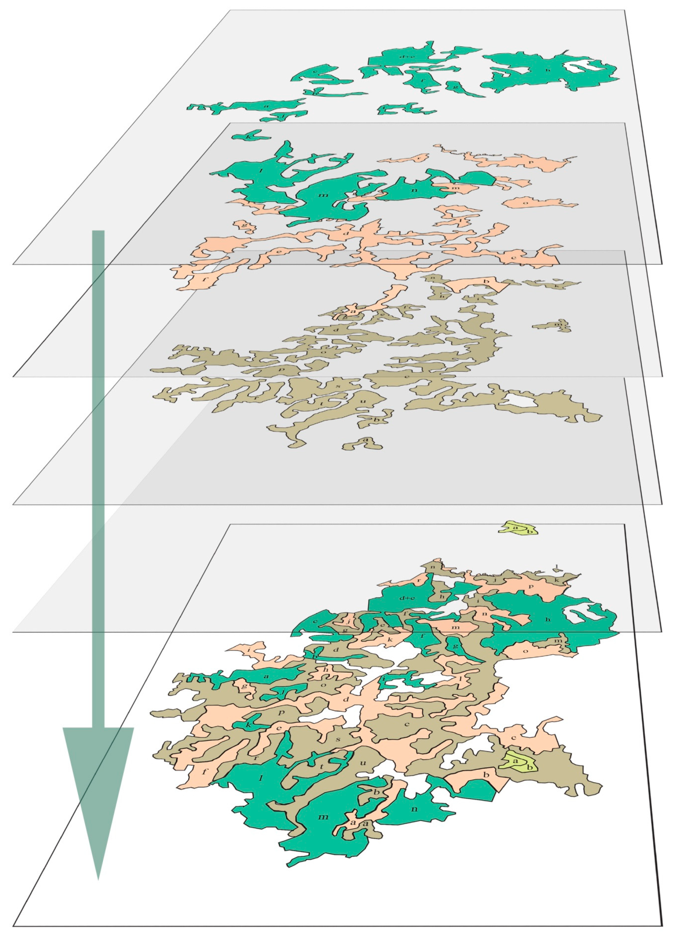
2.7. Average Green Infrastructure Fragmentation Coefficient for the Area under Study

Green infrastructure and its fragmentation can be analyzed similarly to landscape fragmentation using the “matrix-patch-corridor” model, following island biogeography theory as implemented by Forman and Gordon [26,27].
This concept can have a much broader application than in initial studies and is currently used as a tool in forest arrangement plan drafting in Poland. The notion of the patch used in reference to forests can be successfully applied to other ecosystems that comprise green infrastructure.
The approach of the green infrastructural patch in anthropogenic space or in its vicinity is linked with the process of its fragmentation as a result of new development projects [28]. To control and direct fragmentation while minimizing ecosystem damage, it is necessary to determine the state of fragmentation. Preparing a model of calculating average fragmentation coefficients can prove useful in this. This model is based on calculating boundary development indicators (K1 and K2) which describe the edge effect while providing direct information of the similarity of a given ecosystem’s patch to the shape of a circle, which has the most beneficial circumference/surface ration and boundary complexity state—the ratio between boundary length and patch surface.
Of note is that data should be analyzed comprehensively and accounted for as an entire structure. Both the size of the patches and their fragmentation are of significance, as is their distance from one another. [29,30,31]
From the standpoint of green infrastructure, one should pursue models close to Frederick Law Olmsted’s idea, creating areas of greater fragmentation (arising from urban development), but that are connected into a structure (high fragmentation coefficient and low ecosystem element count).
K1 and K2 coefficients are calculated from the formulas below:
K 1 = l e 2 × π × ( p e π ) K 2 = l e p e
l e ecosystem boundary length, expressed in km
p e ecosystem surface, expressed in km2
The average green infrastructure fragmentation coefficient Kf for the municipality’s territory is obtained by calculating the ratio between the sum of average ecosystem fragmentation coefficients (K1 + K2) for ecosystems in the municipality and the number of these ecosystems, namely:
k f = 39.92 4 = 32.24
Any infills in the patches are accounted for as separate elements. Data were obtained from the Carpathian Countries Integrated Biodiversity Information System, WWF Danube (CCIBIS geoportal). We assumed that increasing the size of green infrastructure and its density countered fragmentation.

3. Results

The listing below includes ecosystems located on the territory of the municipality of Łapanów, together with the data that describe them—boundary length and surface area. The input data listing was based on Mapowanie i ocena ekosystemów i ich usług w Polsce by the Center of Information on the Environment UNEP/GRID-Warszawa (UN Environment Programme/Global Resource Information Database) and commissioned by the Ministry of the Environment [32].

Calculation of the Average Green Infrastructure Fragmentation Coefficient for the Territory of Łapanów

The Carpathian region was also subjected to a fragmentation analysis, accounting for division by developed areas and barriers in the form of road infrastructure. Vast open areas were also subjected to fragmentation analysis. Input data for the analyses of the Carpathian region for land cover were forested and tree-covered areas, as well as developed areas (BDOT, BDL), natural objects—trees, rows of trees, bushes, hedges (BDOT), national roads—A, S, GP (BDOT). We have presented the scheme of the analysis in Figure 3.
These analyses have returned information about the state of fragmentation of the entire area of the Carpathian Mountains. They demonstrated that Natura 2000 areas are becoming increasingly isolated areas in the territory under analysis. The analysis also showed areas potentially under serious threat of fragmentation. The efforts of UNEP/GRID identified problem areas in the context of ecological continuity between Natura 2000 areas.
The key conclusion is that sprawling (compact) development is one of the key threats to preserving landscape value and ecological continuity. We have presented a comparison of development types in Carpathian voivodeships in Table 4. This clearly shows that the vast majority of southern Poland’s regions are characterized by compact development, which may have an impact on the status and connectivity of green infrastructure.
As a part of the project, we also analyzed 166 municipalities (out of 200 Carpathian municipalities) in terms of their local planning documents and determined that they offered insufficient protection to green infrastructure. We did not subject the isolated municipalities to a fragmentation analysis due to the cross-sectional character of the report. We shall present the findings in Tables S1–S4 and Table 5 and in Figure 4.
With the help of the GreenGO-Carpathians geoportal and it is spatial database, 4 groups of ecosystems were created: grassy and scrub ecosystems, forest and tree-based ecosystems, ecosystems of mosaic-like farmland and large-scale farmland ecosystems. Then, in accordance with the formulas from Section 2.7 of this paper, the K1 and K2 coefficients for these ecosystems were calculated and summed for the entire ecosystem. In the end the average K1 + K2 coefficient value was calculated. Average green infrastructure fragmentation coefficient for the municipality’s territory is 9.98 (Table 5).
Figure 4 shows a graphical representation of ecosystems for which the coefficients in Tables S1–S4 were calculated. Each layer of a given color constitutes a separate ecosystem and at the bottom all ecosystems are presented as a coherent structure. Light green areas—grassy and scrub ecosystems, green areas-forest and tree-based ecosystems, orange areas-ecosystems of mosaic-like farmland and brown areas—large-scale farmland ecosystems.

4. Discussion

The average fragmentation coefficient in the Łapanów municipality (Figure 5.) was not significantly different than the average GI condition in the municipalities of the Carpathian foothills, which can be assessed based on data featured in CLC 2018—CORINE Land Cover, a project executed as a part of the Copernicus Land Monitoring program. However, the area does have a highly mosaic character, as indicated by Table 5. From the standpoint of green infrastructure continuity, one would have to pay specific attention to creating small-scale connections between GI elements, as the specificity of this region, the mosaic-like character of the landscape and its accompanying functions can allow for such solutions.
Areas that have this type of character require densification of existing infrastructure via the addition of corridor patches [34] along with PMC models (“patch-matrix-corridor”), as first used in the theory of island biogeography by MacArthur and Wilson in 1967 [35], which would also enable the development of localities. It appears necessary to reinforce corridor layouts between forest ecosystem areas located in the Lesser Poland ecological corridor.
For areas with biodiversity and fauna species protection strategies, point elements should be no smaller than areas that can ensure the survival of a minimal population—this size will differ depending on species [36,37]. These conclusions align with studies on landscape and habitat fragmentation by Di Giulio, Holderegger and Tobias [38] and Frederick Law Olmsted’s assumptions about greenery structures [39] and result from the method adopted by Choiński and Borkowski [40] in their study of green infrastructure.
Accounting for guidelines in the necessary shaping of previously oft-ignored green infrastructure can make urbanization processes more sustainable by, among other things, preventing the severing of its elements that are key to ecosystems and migrations and connecting them in areas that require this for biological and functional reasons, such as the 50/500 principle—an area insufficient to ensure the genetic survival of a valuable species which is present in the patch, too large of an edge effect with adverse impact of external noise or microclimate [41,42].

5. Conclusions

As the matter was recognized, it became evident to include the notion of green infrastructure in spatial planning. [43,44] Publications and measures that revolve around the problem and present what green infrastructure is in a clear way include the green infrastructure Planning Guide [45] or UNEP GRID initiatives. Such materials are helpful, but to properly play their part and have real impact on the state of green infrastructure, bottom-up efforts are necessary in the process of creating acts of local law [46,47]. In Polish, Local Spatial Development Plans are such acts. Unfortunately, spatial planning law that is poorly formulated at the local level, which is expressed in there being no obligation to draft local spatial development plans and the non-binding role of municipal strategic documents [48], leads to spatial chaos, which manifests itself primarily in urban sprawl and in the placement of housing in unfit locations.
Formulating a uniform system for assessing the degree of green infrastructure fragmentation for a given area can enable the direction of efforts towards improving green infrastructure functionality in terms of ecosystem operation. The method that uses three fundamental values: patch boundary, patch surface and element number, describes the existing state while allowing us to determine where the structure significantly differs from the optimal shape and element count. Combining small, separated areas of green infrastructures (patches) raises K1 and K2 indicators (which are associated with surface and boundaries). However, it should be noted that it decreases the number of elements, which proves that this method allows us to determine and compare the state of fragmentation of green infrastructure. This method could also be used to assess the state of green infrastructure fragmentation on a smaller scale, e.g., that of a specific locality, where input data could be provided in the form of a more detailed listing of green infrastructure elements than for an ecosystem.

Supplementary Materials

The following are available online at https://www.mdpi.com/1999-4907/12/1/78/s1. Tables S1–S4 show the calculations of the K1 and K2 coefficients for each element of each ecosystem. An average value of the K1 + K2 coefficient for all elements of each ecosystem was drawn from them. Table S1: The average values of the K1 + K2 coefficient for grassy and scrub ecosystems—8.39; Table S2: forest and tree-based ecosystems—135.87; Table S3: ecosystems of mosaic-like farmland—187.62; Table S4: large-scale farmland ecosystems—208.93. The above data were used to further calculate the fragmentation coefficient in Table 5.

Author Contributions

Conceptualization, B.R., H.-G.H.; methodology B.R., H.-G.H.; validation, B.R., H.-G.H.; data analysis, H.-G.H., H.-N.A.; writing—original draft preparation B.R., H.-G.H., H.-N.A.; writing—review and editing, B.R., H.-N.A., visualization, H.-G.H., H.-N.A.; supervision, B.R.; All authors have read and agreed to the published version of the manuscript.

Funding

This research received no external funding.

Acknowledgments

This paper would not have been possible without shared materials from UNEP/GRID-Warsaw. Special thanks to Piotr Mikołajczyk for his valuable comments and the substantive assistance. The authors thank Krzysztof Barnaś for editorial help.

Conflicts of Interest

The authors declare no conflict of interest.

References

  1. European Commission. Communication from the Commision to the European Parliament, The Council, The European Economic and Social Comittee and the Committee of the Regions. Green Infrastructure (GI)—Enhancing Europe’s Natural Capital; (COM (2013) 249 final); European Commission: Luxembourg, 2013. [Google Scholar]
  2. Sandström, U.G. Green infrastructure planning in urban Sweden. Plan. Pract. Res. 2002, 17, 373–385. [Google Scholar] [CrossRef]
  3. Schilling, J.; Logan, J. Greening the rust belt: A green infrastructure model for right sizing America’s shrinking cities. J. Am. Plan. Assoc. 2008, 74, 451–466. [Google Scholar] [CrossRef]
  4. Riitters, K.; Wickham, J.; Vogelmann, J.; Jones, K. National Land-Cover Pattern Data. Ecology 2000, 81, 604. [Google Scholar] [CrossRef]
  5. Laurance, W.F. Predicting the Impacts of Edge Effects in Fragmented Habitats. Biol. Conserv. 1991, 55, 77–92. [Google Scholar] [CrossRef]
  6. Thiele, J.; Schuckert, U.; Otte, A. Cultural landscapes of Germany are patch-corridor-matrix mosaics for an invasive megaforb. Landsc. Ecol. 2008, 23, 453–465. [Google Scholar] [CrossRef]
  7. Tzoulas, K.; Korpela, K.; Venn, S.; Yli-Pelkonen, V.; Kaźmierczak, A.; Niemela, J.; James, P. Promoting ecosystem and human health in urban areas using Green Infrastructure: A literature review. Landsc. Urban Plan. 2007, 81, 167–178. [Google Scholar] [CrossRef] [Green Version]
  8. Ahern, J. Green Infrastructure for Cities The Spatial Dimension. Available online: https://www.semanticscholar.org/paper/Green-Infrastructure-For-Cities-The-Spatial-Ahern/5a5eaa2f3394bf3c8e5eb4400812b2d3c822eb9d (accessed on 27 November 2020).
  9. Firehock, K. A Short History of the Term Green Infrastructure and Selected Literature. Available online: http://www.gicinc.org/PDFs/GI%20History.pdf (accessed on 27 November 2020).
  10. Da Silva, J.M.C.; Wheeler, E. Ecosystems as infrastructure. Perspect. Ecol. Conserv. 2017, 15, 32–35. [Google Scholar] [CrossRef]
  11. Benedict, M.A.; McMahon, E.T. Green Infrastructure: Smart Conservation for the 21st Century. Renew. Res. J. 2002, 20, 12–17. [Google Scholar]
  12. The President’s Council on Sustainable Development. Towards a Sustainable America—Advancing Prosperity, Opportunity, and a Healthy Environment for the 21st Century; The President’s Council on Sustainable Development: Washington, DC, USA, 1999. [Google Scholar]
  13. European Commission. Regulation of the European Parliament and The Council on the Cohesion Fund and repealing Council Regulation (EC) No 1084/2006; (COM (2011) 612 final/2); European Commission: Luxembourg, 2012. [Google Scholar]
  14. European Commission. Regulation of the European Parliament and of the Council on specific Provisions Concerning the European Regional Development Fund and the Investment for Growth and Jobs Goal and Repealing Regulation (EC) No 1080/2006; (COM (2011) 614 final); European Commission: Luxembourg, 2011. [Google Scholar]
  15. United Nations. United Nations Framework Convention on Climate Change; United Nations: New York, NY, USA, 1992. [Google Scholar]
  16. Slätmo, E.; Nilsson, K.; Turunen, E. Implementing Green Infrastructure in Spatial Planning in Europe. Land 2019, 8, 62. [Google Scholar] [CrossRef] [Green Version]
  17. Weber, T.; Wolf, J. Maryland’s Green Infrastructure—Using Landscape Assessment Tools to Identify a Regional Conservation Strategy. Environ. Monit. Assess. 2000, 63, 265–277. [Google Scholar] [CrossRef]
  18. Benedict, M.A.; McMahon, E.T. Green Infrastructure Linking Landscapes and Communities. In The Conservation Fund; Island Press: Washington, DC, USA, 2006; ISBN 1-59726-027-4. [Google Scholar]
  19. Mell, I.C. Green infrastructure: Concepts, Perceptions and Its Use in Spatial Planning. Ph.D. Thesis, School of Architecture, Planning and Landscape Newcastle University, Newcastle, UK, 2010. [Google Scholar]
  20. Dennis, M.; Barlow, D.; Cavan, G.; Cook, P.A.; Gilchrist, A.; Handley, J.; James, P.; Thompson, J.; Tzoulas, K.; Wheater, C.P.; et al. Mapping Urban Green Infrastructure: A Novel Landscape-Based Approach to Incorporating Land Use and Land Cover in the Mapping of Human-Dominated Systems. Land 2018, 7, 17. [Google Scholar] [CrossRef] [Green Version]
  21. Panagopoulos, T. Special Issue: Landscape Urbanism and Green Infrastructure. Land 2019, 8, 112. [Google Scholar] [CrossRef] [Green Version]
  22. Snäll, T.; Lehtomäki, J.; Arponen, A.; Elith, J.; Moilanen, A. Green Infrastructure Design Based on Spatial Conservation Prioritization and Modeling of Biodiversity Features and Ecosystem Services. Environ. Manag. 2016, 57, 251–256. [Google Scholar] [CrossRef] [PubMed] [Green Version]
  23. Carpathian Convention. Framework Convention on the Protection and Sustainable Development of the Carpathians; Carpathian Convention: Kyiv, Ukraine, 2003. [Google Scholar]
  24. Hrehorowicz-Gaber, H. Contemporary Changes and Development of Spatial Structures in the Carpathians: Conditions and Development Models; Cracow University of Technology: Cracow, Poland, 2019. [Google Scholar]
  25. Lapanow Municipal Council. Uchwała Nr VII/44/03 Rady Gminy Łapanów z dnia 4 lipca 2003 r. w Sprawie: Uchwalenia “Miejscowego Planu Zagospodarowania Przestrzennego Gminy Łapanów”; Lapanow Municipal Council: Lapanow, Poland, 2003. [Google Scholar]
  26. Forman, R.T.T.; Godron, M. Landscape Ecology; Wiley: New York, NY, USA, 1986; ISBN 978-0-471-87037-1. [Google Scholar]
  27. Vogt, P.; Riitters, K.H.; Estreguil, C.; Kozak, J.; Wade, T.G.; Wickham, J.D. Mapping Spatial Patterns with Morphological Image Processing. Landsc. Ecol. 2007, 22, 171–177. [Google Scholar] [CrossRef]
  28. Fahrig, L. Effects of Habitat Fragmentation on Biodiversity. Annu. Rev. Ecol. Evol. Syst. 2003, 34, 487–515. [Google Scholar] [CrossRef] [Green Version]
  29. Wintle, B.A.; Kujala, H.; Whitehead, A.; Cameron, A.; Veloz, S.; Kukkala, A.; Moilanen, A.; Gordon, A.; Lentini, P.E.; Cadenhead, N.C.R.; et al. Global synthesis of conservation studies reveals the importance of small habitat patches for biodiversity. Proc. Natl. Acad. Sci. USA 2019, 116, 909–914. [Google Scholar] [CrossRef] [Green Version]
  30. Blazy, R. Living Environment Quality Determinants, Including PM2.5 and PM10 Dust Pollution in the Context of Spatial Issues—The Case of Radzionków. Buildings 2020, 10, 58. [Google Scholar] [CrossRef] [Green Version]
  31. Valdés, A.; Lenoir, J.; Frenne, P.D.; Andrieu, E.; Brunet, J.; Chabrerie, O.; Cousins, S.A.O.; Deconchat, M.; Smedt, P.D.; Diekmann, M.; et al. High ecosystem service delivery potential of small woodlands in agricultural landscapes. J. Appl. Ecol. 2020, 57, 4–16. [Google Scholar] [CrossRef] [Green Version]
  32. Mikołajczyk, P.; Szewczyk, M.; Andrzejewska, M.; Rusztecka, M.; Jabłońska, B.; Starczewski, D. Mapowanie i Ocena Ekosystemów i ich Usług w Polsce; GRID: Warsaw, Poland, 2015. [Google Scholar]
  33. Carpathians Unite—Green Infrastructure. Available online: https://mapa.karpatylacza.pl/GreenGO-Carpathians (accessed on 27 November 2020).
  34. Maciantowicz, M. Fragmentacja kompleksów leśnych jako istotne zagrożenie cywilizacyjne. Stud. Mater. Cent. Eduk. Przyr. Leśnej Rogowie 2018, 20, 40–49. [Google Scholar]
  35. MacArthur, R.H.; Wilson, E.O. The Theory of Island Biogeography; Princeton University Press: Princeton, NJ, USA, 2001; ISBN 978-0-691-08836-5. [Google Scholar]
  36. Frankel, O.; Soulé, M.E. Conservation and Evolution; Cambridge University Press: Cambridge, UK, 1981; ISBN 978-0-521-29889-6. [Google Scholar]
  37. Soulé, M.E. Viable Populations for Conservation; Cambridge University Press: Cambridge, UK, 1987; ISBN 978-0-521-33657-4. [Google Scholar]
  38. Giulio, M.D.; Holderegger, R.; Tobias, S. Effects of habitat and landscape fragmentation on humans and biodiversity in densely populated landscapes. J. Environ. Manag. 2009, 90, 2959–2968. [Google Scholar] [CrossRef]
  39. Eisenman, T.S. Frederick Law Olmsted, Green Infrastructure, and the Evolving City. J. Plan. Hist. 2013, 12, 287–311. [Google Scholar] [CrossRef] [Green Version]
  40. Choiński, A.; Borkowski, G. Waloryzacja jezior dla potrzeb turystyki i wypoczynku. In Uwarunkowania i Plany Rozwoju Turystyki; Wydawnictwo Naukowe UAM: Poznań, Poland, 2008; Volume I—Przyrodnicze Zasoby Turystyczne i Metody ich Oceny, pp. 35–58. [Google Scholar]
  41. Frankham, R.; Bradshaw, C.J.A.; Brook, B.W. Genetics in conservation management: Revised recommendations for the 50/500 rules, Red List criteria and population viability analyses. Biol. Conserv. 2014, 170, 56–63. [Google Scholar] [CrossRef]
  42. Manton, M.; Angelstam, P. Defining Benchmarks for Restoration of Green Infrastructure: A Case Study Combining the Historical Range of Variability of Habitat and Species’ Requirements. Sustainability 2018, 10, 326. [Google Scholar] [CrossRef] [Green Version]
  43. Verburg, P.H.; Schot, P.P.; Dijst, M.J.; Veldkamp, A. Land use change modelling: Current practice and research priorities. GeoJournal 2004, 61, 309–324. [Google Scholar] [CrossRef]
  44. Wang, J.; Pauleit, S.; Banzhaf, E. An Integrated Indicator Framework for the Assessment of Multifunctional Green Infrastructure—Exemplified in a European City. Remote Sens. 2019, 11, 1869. [Google Scholar] [CrossRef] [Green Version]
  45. Davies, C.; Macfarlane, R.; Mcgloin, C.; Roe, M. Green Infrastructure Planning Guide Authors; Northumbria University: Newcastle, UK, 2015. [Google Scholar]
  46. Niedźwiecka-Filipiak, I.; Rubaszek, J.; Potyrała, J.; Filipiak, P. The Method of Planning Green Infrastructure System with the Use of Landscape-Functional Units (Method LaFU) and its Implementation in the Wrocław Functional Area (Poland). Sustainability 2019, 11, 394. [Google Scholar] [CrossRef] [Green Version]
  47. Yacamán Ochoa, C.; Ferrer Jiménez, D.; Mata Olmo, R. Green Infrastructure Planning in Metropolitan Regions to Improve the Connectivity of Agricultural Landscapes and Food Security. Land 2020, 9, 414. [Google Scholar] [CrossRef]
  48. Ministry of Construction, Spatial and Housing Economy; The Council Of Ministers. Act on Spatial Planning and Development. J. Laws U. 2003, 80, 717. [Google Scholar]
Figure 1. Layout of selected Polish municipalities of the Carpathian Mountains region against the background of the Lesser Poland ecological corridor along with the access isochrone for Krakow. Legend: a—access isochrone for Krakow residents; b—Krakow city limits; c—Krakow city center; d—selected municipalities of the Carpathian Foothills; e—municipality of Łapanów, selected for analysis; f—Lesser Poland ecological corridors—an illustrative course of ecological corridors made on the basis of spatial data prepared under the task “Preparation of a spatial database on ecological corridors in Małopolska—step I” carried out by Regional Directorate for Environmental Protection in Kraków, Department of Nature Conservation and Natura 2000 Areas.
Forests 12 00078 g001
Figure 2. Location of the Carpathian region in Poland (on the left side) and the schema of the Łapanów municipality ecological system with its ecological corridors and major ecosystems marked in green (on the right side). 1—municipality boundary; 2—larger forest ecosystems; 3—natable; 4—Lesser Poland ecological network; 5—Lesser Poland ecological corridor; 6—areas at risk of Figure; 7—local groundwater reservoir “Stradomka”; 8—areas of active landslides; 9—areas of movement of earth masses; 10—selected areas requiring supplementation of green infrastructure.
Forests 12 00078 g002
Figure 3. Stages of fragmentation analysis based on Carpathian Countries Integrated Biodiversity Information System, WWF Danube (CCIBIS) geoportal.
Forests 12 00078 g003
Figure 4. Ecosystems of the territory of Łapanów municipality—output data for the average green infrastructure fragmentation coefficient.
Forests 12 00078 g004
Figure 5. Location of ecosystems and the Lesser Poland ecological corridor within the Łapanów municipality along with the suggested direction of reinforcing the corridor layout. Light green areas—grassy and scrub ecosystems, green areas-forest and tree-based ecosystems, orange areas-ecosystems of mosaic-like farmland and brown areas—large-scale farmland ecosystems, red color anthropomorphic ecosystems. Source [33].
Forests 12 00078 g005
Table 1. Globally significant institutions that fund measures associated with green infrastructure https://cdrpc.org/gi-code-audit.
InitiativeNumber of SignatoriesMajor Signatories
Global Reporting InitiativeOver 960 organizationsABN AMRO, HSBC, Citigroup, Barclays
UNEP Finance Initiative176 institutionsBank of America, Credit Suisse Group, JPMorgan Chase and Co.
UN Principles for Responsible InvestmentOver 850 organizationsCalPERS, ABP, Swiss Re, etc.
UN Global Compact8700 organizations (6500 organizations and business associations and 2200 nonprofits)Deutche Bank, ING Group, Mitsubishi, UFJ
The Equator Principles67Citigroup, ABN AMRO, Barclays, WestLB
Carbon Disclosure Project534 Fls holding, US$64 trillion in assets, 60 purchasing organizations 3000 organizations in about 60 countriesGoldman Sachs, Morgan Stanley, CalPERS, Cadbury, PepsiCo, Walmart
Institutional Investors’ Group on Climate ChangeOver 20 UN agenciesThe Bretton Woods Institutions, an issue management group (IMG) on green economy
UN Secretary-General’s High-Level Advisory Group on Climate Change FinancingThree heads of state and 10 high office holders and public and private sector leadersN/A
Table 2. Comparison of conditions in rural foothill municipalities that act as recreational areas for residents of the Krakow agglomeration. Based on: http://www.turystyka-karpaty.pl/art/files/16.
Municipalities Selected for ComparisonCultural InfrastructureTourism InfrastructureEssential Green Infrastructure Elements
MunicipalitySignificant Tangible HeritageAccommodations/GastronomyAgricultural Landscape/DisappearanceForest Cover (District Average/Municipality)Open Waters Used for Recreation
Łapanów28.4/26.6
Trzciana28.4/23.9
Gdów●/○15.6/9.8
Biskupice●/○15.6/8.6
Kłaj15.6/44.6
Mogilany●/○12.3/13.0
Świątniki Górne●/○12.3/13.9
●—condition fulfilled; ○—condition not met; ●/○—condition fulfilled to a limited extent.
Table 3. Analysis of the local spatial development plan for the municipality of Łapanów in terms of green infrastructure provisions.
Local Spatial Development Plan ProvisionBeneficial to GINotes
Assignation of class III (max 0.5 ha), IV (max 1 ha) and VI farmland to non-agricultural useNo conditions of land-use change that would compensate for GI loss
Protection of acoustic climate in single-family housing areas, single-family housing and tourist accommodation areas, single-family housing and service areasAllows for creating minor enclaves of greenery—less severe edge effect
Prohibition on activity that is a nuisance to the environment, which threatens water management infrastructure and natural surface and underground water resourcesBlue infrastructure—no definition of nuisance. Applies only to water—no provisions concerning animal habitats
Building footprint/plot area ratio (MN)Max 40%
Biologically active area/plot area ratio (MN)Min 40%
Prohibition on wastewater disposal and economic activity that could worsen natural conditions in the Stradomka River Valley
Prohibition activity that can lead to large-scale pollution in areas of the conservation of the “Dolina Stradomki”’ Main Underground Water Reservoir GZWP no. 442 and IBŁ reservoir (Iwkowa–Bochnia–Lapanów)
Building footprint/plot area ratio—max 80%
Biologically active area/plot area ratio—min. 10%
With a possibility of adjusting these indicators to local conditions in Łapanów—in street frontages or along the voivodeship road along the northern edge of the market square and in Grab at site Z23.MN.U.
Possibility of adaptation to local conditions—possibly exploitable
Enhancement with landscaped greenery—tall or low, in ŁapanówNo indications of whether domestic species are preferred or not
Roofing should be made of roof tiles, metal sheets or wooden shinglesNo green roofs allowed—benefit or hindrance?
Natural greenery—including forest greenery and tree stands—should be protected when developing land covered by the plan.
New plantings should maintain the greenery’s natural character—adapted to the location and function of buildings.Natural character of greenery—does not explicitly state a preference for domestic species or design (lawns)
Plot front width should be at least 16 m for detached single-family housesFragmentation prevention, preservation of green spaces
Priority functio-spatial regions—area of agriculture and area of recreation, for which the provisions are intended to preserve cultural and landscape assets of the municipality’s territory and protection against introducing grouped manufacturing functions into housing and service areas. Agriculture priority area and recreation priority area
Areas with restrictions and environmental protection provisions
Incorporation of the Municipality’s territory into the ecological network via the Wiśnicz Foothills Protected Landscape Region
Agriculture is to be the temporary form of land-use in areas for development
Protection of high-quality class soils from developmentAre projects like parks also prohibited?
Protection of agricultural areas of exceptional landscape valueNo mention of paths, the mosaic-like character of agricultural areas, no specifics as to what areas of exceptional landscape values are
Melioration, particularly of permanent green land-use (due to poor soil moisture)
Transformation of agricultural land-use into meadows and pastures
Zone of unconditional protection against development in forested areas and the immediate biological buffer zone of rivers and creeks
Prohibition on any activity that threatens existing forest resources
Delineation of functional zones with adaptation of development or no such option
Modernization of farms, development of farming production and service centers✓/✕No conditions that would compensate for any environmental losses incurred
Efforts to recognize all forest patches in the municipality as protective forestsNo definition of the types and percentage composition of different types of protective forests (recreational, geo-protective, climatic, etc.)
Execution of afforestation programs in existing forest areas and afforestation of existing agricultural production areas of the lowest value.
Table 4. Development and development types in the territory of Carpathian voivodeships in Poland.
VoivodeshipTotal Developed Area to Plot Ratio in the VoivodeshipLoose Development (%)Compact Development (%)
Lesser Poland18.5018.9081.10
Subcarpathian10.6218.5681.44
Silesian20.9010.1289.88
Table 5. Average green infrastructure fragmentation results for the municipality of Łapanów.
EcosystemSum of an Ecosystem’s Elements’ (Patches’) Fragmentation CoefficientsNumber of Elements (Patches) of a Given EcosystemAverage K1 + K2 Coefficient Value
Grassy and scrub8.3918.39
Forest and tree-based135.871310.45
Mosaic-type farmland173.381610.84
Large-scale farmland194.571910.24
Sum total 39.92
Average green infrastructure fragmentation coefficient for the municipality’s territory39.92:49.98
Publisher’s Note: MDPI stays neutral with regard to jurisdictional claims in published maps and institutional affiliations.

