Synergy of Active and Passive Remote Sensing Data for Effective Mapping of Oil Palm Plantation in Malaysia
Abstract
1. Introduction
2. Materials and Methods
2.1. Study Region
2.2. Datasets
2.3. Methods
2.3.1. Preprocessing of Radar Data
2.3.2. Preprocessing of Optical Data
2.3.3. Texture Measurement of Radar Data
2.3.4. Extraction of Threshold Values
2.3.5. Accuracy Assessment
3. Results
3.1. Detection of Oil Palm in HH and HV Polarization Radar Data
3.2. Detection and Discrimination of Misclassified Land Covers from Oil Palm
3.3. Mapping of Oil Palm
3.4. Validation of Oil Palm Mapping
4. Discussion
4.1. Oil Palm Mapping with Radar (Backscattering) and Optical (Reflectance) Data Threshold
4.2. Misclassification of Oil Palm (Source of Errors)
4.3. Forest Conservation and Sustainability
5. Conclusions
Author Contributions
Funding
Acknowledgments
Conflicts of Interest
References
- Alam, M.Z.; Mamun, A.A.; Qudsieh, I.Y.; Muyibi, S.A.; Salleh, H.M.; Omar, N.M. Solid state bioconversion of oil palm empty fruit bunches for cellulase enzyme production using a rotary drum bioreactor. Biochem. Eng. J. 2009, 46, 61–64. [Google Scholar] [CrossRef]
- Kho, L.K.; Jepsen, M.R. Carbon stock of oil palm plantations and tropical forests in Malaysia: A review. Singap. J. Trop. Geogr. 2015, 36, 249–266. [Google Scholar] [CrossRef]
- Malaysian Palm Oil Board (MPOB). Available online: http://bepi.mpob.gov.my/index.php/en/ (accessed on 23 May 2016).
- Lamade, E.; Bouillet, J.-P. Carbon storage and global change: The role of oil palm. OléagineuxCorps GrasLipides 2005, 12, 154–160. [Google Scholar] [CrossRef]
- Felda Global Ventures (FGV). Available online: http://www.fgvholdings.com/ (accessed on 15 July 2017).
- Tan, K.P. Estimating Primary Productivity of Oil Palm Peninsular Malaysia Using Remote Sensing and Ancillary Data. Ph.D. Thesis, Universiti Teknologi Malaysia, Iskandar Puteri, Malaysia, 2014. [Google Scholar]
- Zahari, M.A.; Zakaria, M.R.; Ariffin, H.; Mokhtar, M.N.; Salihon, J.; Shirai, Y.; Hassan, M.A. Renewable sugars from oil palm frond juice as an alternative novel fermentation feedstock for value-added products. Bioresour. Technol. 2012, 110, 566–571. [Google Scholar] [CrossRef] [PubMed]
- Shafri, H.Z.M.; Hamdan, N.; Saripan, M.I. Semi-automatic detection and counting of oil palm trees from high spatial resolution airborne imagery. Int. J. Remote Sens. 2011, 32, 2095–2115. [Google Scholar] [CrossRef]
- Nooni, I.K.; Duker, A.A.; Van Duren, I.; Addae-Wireko, L.; Osei Jnr, E.M. Support vector machine to map oil palm in a heterogeneous environment. Int. J. Remote Sens. 2014, 35, 4778–4794. [Google Scholar] [CrossRef]
- Srestasathiern, P.; Rakwatin, P. Oil Palm Tree Detection with High Resolution Multi-Spectral Satellite Imagery. Remote Sens. 2014, 6, 9749–9774. [Google Scholar] [CrossRef]
- Lee, J.S.H.; Wich, S.; Widayati, A.; Koh, L.P. Detecting industrial oil palm plantations on Landsat images with Google Earth Engine. Remote Sens. Appl. Soc. Environ. 2016, 4, 219–224. [Google Scholar] [CrossRef]
- Thanh Noi, P.; Kappas, M. Comparison of Random Forest, k-Nearest Neighbor, and Support Vector Machine Classifiers for Land Cover Classification Using Sentinel-2 Imagery. Sensors 2017, 18, 18. [Google Scholar] [CrossRef]
- Glinskis, E.A.; Gutiérrez-Vélez, V.H. Quantifying and understanding land cover changes by large and small oil palm expansion regimes in the Peruvian Amazon. Land Use Policy 2019, 80, 95–106. [Google Scholar] [CrossRef]
- Thenkabail, P.S.; Stucky, N.; Griscom, B.W.; Ashton, M.S.; Diels, J.; Van der Meer, B.; Enclona, E. Biomass estimations and carbon stock calculations in the oil palm plantations of African derived savannas using IKONOS data. Int. J. Remote Sens. 2004, 25, 5447–5472. [Google Scholar] [CrossRef]
- Koh, L.P.; Miettinen, J.; Liew, S.C.; Ghazoul, J. Remotely sensed evidence of tropical peatland conversion to oil palm. Proc. Natl. Acad. Sci. USA 2011, 108, 5127–5132. [Google Scholar] [CrossRef] [PubMed]
- Gutiérrez-Velez, V.H.; Uriarte, M.; Defries, R.; Pinedo-Vasquez, M.; Fernandes, K.; Ceccato, P.; Baethegen, W.; Padoch, C. Land cover change interacts with drought severity to change fire regimes in Western Amazonia. Ecol. Appl. 2014, 24, 1323–1340. [Google Scholar] [CrossRef] [PubMed]
- Chong, K.L.; Kanniah, K.D.; Pohl, C.; Tan, K.P. A review of remote sensing applications for oil palm studies. Geo-Spat. Inf. Sci. 2017, 20, 184–200. [Google Scholar] [CrossRef]
- Teng, K.C.; Koay, J.Y.; Tey, S.H.; Lim, K.S.; Ewe, H.T.; Chuah, H.T. A Dense Medium Microwave Backscattering Model for the Remote Sensing of Oil Palm. IEEE Trans. Geosci. Remote Sens. 2014, 53, 3250–3259. [Google Scholar] [CrossRef]
- Sinha, S.; Jeganathan, C.; Sharma, L.K.; Nathawat, M.S. A review of radar remote sensing for biomass estimation. Int. J. Environ. Sci. Technol. 2015, 12, 1779–1792. [Google Scholar] [CrossRef]
- Rosenqvist, A. Evaluation of JERS-1, ERS-1 and Almaz SAR backscatter for rubber and oil palm stands in West Malaysia. Int. J. Remote Sens. 1996, 17, 3219–3231. [Google Scholar] [CrossRef]
- Miettinen, J.; Liew, S.C. Separability of insular Southeast Asian woody plantation species in the 50 m resolution ALOS PALSAR mosaic product. Remote Sens. Lett. 2010, 2, 299–307. [Google Scholar] [CrossRef]
- Dong, J.; Xiao, X.; Sheldon, S.; Biradar, C.; Zhang, G.; Duong, N.D.; Hazarika, M.; Wikantika, K.; Takeuhci, W.; Moore, B., III. A 50-m forest cover map in Southeast Asia from ALOS/PALSAR and its application on forest fragmentation assessment. PLoS ONE 2014, 9, e85801. [Google Scholar] [CrossRef]
- Li, L.; Dong, J.; Njeudeng Tenku, S.; Xiao, X. Mapping Oil Palm Plantations in Cameroon Using PALSAR 50-m Orthorectified Mosaic Images. Remote Sens. 2015, 7, 1206–1224. [Google Scholar] [CrossRef]
- Cheng, Y.; Yu, L.; Cracknell, A.P.; Gong, P. Oil palm mapping using Landsat and PALSAR a case study in Malaysia. Int. J. Remote Sens. 2016, 37, 5431–5442. [Google Scholar] [CrossRef]
- Lee, K.Y.; Bretschneider, T.R. Segmentation of dual-frequency polarimetric sar data for an improved land cover classification. In Proceedings of the 31st Asian Conference on Remote Sensing 2010, Hanoi, Vietnam, 1–5 November 2010. [Google Scholar]
- Daliman, S.; Rahman, S.A.; Bakar, S.A.; Busu, I. Segmentation of oil palm area based on GLCMSVM and NDVI. In IEEE TENSYMP 2014, Proceedings of the 2014 IEEE Region 10 Symposium, Kuala Lumpur, Malaysia, 14–16 April 2014; Institute of Electrical and Electronics Engineers (IEEE): Piscataway Township, NJ, USA.
- Morel, A.C.; Fisher, J.B.; Malhi, Y. Evaluating the potential to monitor aboveground biomass in forest and oil palm in Sabah, Malaysia, for 2000–2008 with Landsat ETM+ and ALOS-PALSAR. Int. J. Remote Sens. 2012, 33, 3614–3639. [Google Scholar] [CrossRef]
- Pirker, J.; Mosnier, A.; Kraxner, F.; Havlík, P.; Obersteiner, M. What are the limits to oil palm expansion? Glob. Environ. Chang. 2016, 40, 73–81. [Google Scholar] [CrossRef]
- Cheng, Y.; Yu, L.; Xu, Y.; Lu, H.; Cracknell, A.P.; Kanniah, K.; Gong, P. Mapping oil palm extent in Malaysia using ALOS-2 PALSAR-2 data. Int. J. Remote Sens. 2017, 39, 432–452. [Google Scholar] [CrossRef]
- Cheng, Y.; Yu, L.; Xu, Y.; Lu, H.; Cracknell, A.P.; Kanniah, K.; Gong, P. Mapping oil palm plantation expansion in Malaysia over the past decade (2007–2016) using ALOS-1/2 PALSAR-1/2 data. Int. J. Remote Sens. 2019, 1–20. [Google Scholar] [CrossRef]
- Santos, C.; Messina, J.P. Multi-sensor data fusion for modeling African palm in the Ecuadorian Amazon. Photogramm. Eng. Remote Sens. 2008, 74, 711–723. [Google Scholar] [CrossRef]
- Rakwatin, P.; Longépé, N.; Isoguchi, O.; Shimada, M.; Uryu, Y.; Takeuchi, W. Using multiscale texture information from ALOS PALSAR to map tropical forest. Int. J. Remote Sens. 2012, 33, 7727–7746. [Google Scholar] [CrossRef]
- Fadaei, H.; Ishii, R.; Suzuki, R.; Kendawang, J.J. Detection of oil palm and acacia plantation areas using object based classification in sarawak, Malaysia. In Proceedings of the 34th Asian Conference on Remote Sensing 2013, ACRS 2013, Bali, Indonesia, 20–24 October 2013. [Google Scholar]
- Sim, C.K.; Abdullah, K.; Mat Jafri, M.Z.; Lim, H.S. Combination of radar and optical remote sensing data for land cover/use mapping. In Proceedings of the International Conference on Space Science and Communication, IconSpace, Melaka, Malaysia, 1–3 July 2013. [Google Scholar]
- Torbick, N.; Ledoux, L.; Salas, W.; Zhao, M. Regional Mapping of Plantation Extent Using Multisensor Imagery. Remote Sens. 2016, 8, 236. [Google Scholar] [CrossRef]
- Malaysia Meterological Department. Available online: http://www.met.gov.my/ (accessed on 15 July 2014).
- Hock, S.S. The Population of Peninsular Malaysia; Institute of Southeast Asian Studies: Singapore, 2007. [Google Scholar]
- Corley, R.; Gray, B.; Kee, N. Productivity of the Oil Palm (Elaeis guineensis Jacq.) in Malaysia. Exp. Agric. 1971, 7, 129–136. [Google Scholar] [CrossRef]
- Japan Aerospace Exploration Agency (JAXA). Available online: http://global.jaxa.jp/ (accessed on 12 May 2016).
- USGS Global Visualization Viewer (GloVis). Available online: http://glovis.usgs.gov (accessed on 12 May 2016).
- European Space Agency (ESA). Available online: https://Sentinel.esa.int/web/Sentinel/Sentinel-data-access (accessed on 12 May 2016).
- Derek Watkins 30-Meter SRTM Tile Downloader. Available online: http://dwtkns.com/srtm30m/ (accessed on 14 May 2016).
- Rosenqvist, A.; Shimada, M.; Ito, N.; Watanabe, M. ALOS PALSAR: A Pathfinder Mission for Global-Scale Monitoring of the Environment. IEEE Trans. Geosci. Remote Sens. 2007, 45, 3307–3316. [Google Scholar] [CrossRef]
- Harris Geospatial. Available online: https://www.harrisgeospatial.com/docs/AdaptiveFilters.html#Lee (accessed on 11 June 2020).
- Agustin, S.; Devi, P.A.R.; Sutaji, D.; Fahriani, N. Oil palm age classification on satellite imagery using fractal-based combination. J. Theor. Appl. Inf. Technol. 2016, 89, 18. [Google Scholar]
- USGS. Available online: https://www.usgs.gov/faqs/how-landsat-8-coastalaerosol-band-1-used?qt-news_science_products=0#qt-news_science_products (accessed on 17 April 2020).
- Lv, H.; Wang, Y.; Yang, Y. Thin cloud detection using spectral similarity in coastal and blue bands of landsat-8 data. In Proceedings of the 2017 IEEE International Geoscience and Remote Sensing Symposium (IGARSS), Fort Worth, TX, USA, 23–28 July 2017; pp. 4677–4680. [Google Scholar]
- Haralick, R.M.; Shanmugam, K.; Dinstein, I. Textural Features for Image Classification. IEEE Trans. Syst. Man Cybern. 1973, SMC-3, 610–621. [Google Scholar] [CrossRef]
- Venkatappa, M.; Sasaki, N.; Shrestha, R.P.; Tripathi, N.K.; Ma, H.O. Determination of vegetation thresholds for assessing land use and land use changes in Cambodia using the Google Earth Engine cloud-computing platform. Remote Sens. 2019, 11, 1514. [Google Scholar] [CrossRef]
- Fernández, I.C.; Morales, N.S. One-class land-cover classification using MaxEnt: The effect of modelling parameterization on classification accuracy. PeerJ 2019, 7, e7016. [Google Scholar] [CrossRef]
- Hashim, H.; Abd Latif, Z.; Adnan, N.A. Urban vegetation classification with NDVI threshold value method with very high resolution (VHR) PLEIADES Imagery. In The International Archives of the Photogrammetry, Remote Sensing and Spatial Information Sciences, Proceedings of the 2019 6th International Conference on Geomatics and Geospatial Technology (GGT 2019), Kuala Lumpur, Malaysia, 1–3 October 2019; Elsevier: Amsterdam, The Netherlands, 2019; pp. 237–240. [Google Scholar]
- Di Baldassarre, G.; Schumann, G.; Brandimarte, L.; Bates, P. Timely low resolution SAR imagery to support floodplain modelling: A case study review. Surv. Geophys. 2011, 32, 255–269. [Google Scholar] [CrossRef]
- Bolanos, S.; Stiff, D.; Brisco, B.; Pietroniro, A. Operational surface water detection and monitoring using Radarsat 2. Remote Sens. 2016, 8, 285. [Google Scholar] [CrossRef]
- Behnamian, A.; Banks, S.; White, L.; Brisco, B.; Millard, K.; Pasher, J.; Chen, Z.; Duffe, J.; Bourgeau-Chavez, L.; Battaglia, M. Semi-automated surface water detection with synthetic aperture radar data: A wetland case study. Remote Sens. 2017, 9, 1209. [Google Scholar] [CrossRef]
- Wang, Y.; Hess, L.L.; Filoso, S.; Melack, J.M. Understanding the radar backscattering from flooded and nonflooded Amazonian forests: Results from canopy backscatter modeling. Remote Sens. Environ. 1995, 54, 324–332. [Google Scholar] [CrossRef]
- Townsend, P.A. Relationships between forest structure and the detection of flood inundation in forested wetlands using C-band SAR. Int. J. Remote Sens. 2002, 23, 443–460. [Google Scholar] [CrossRef]
- Manjusree, P.; Prasanna Kumar, L.; Bhatt, C.M.; Rao, G.S.; Bhanumurthy, V. Optimization of threshold ranges for rapid flood inundation mapping by evaluating backscatter profiles of high incidence angle SAR images. Int. J. Disaster Risk Sci. 2012, 3, 113–122. [Google Scholar] [CrossRef]
- Riou, M.È.; Rioux, F.; Lamothe, G.; Doucet, É. Validation and reliability of a classification method to measure the time spent performing different activities. PLoS ONE 2015, 10, e0128299. [Google Scholar] [CrossRef] [PubMed]
- Martinis, S.; Rieke, C. Backscatter Analysis Using Multi-Temporal and Multi-Frequency SAR Data in the Context of Flood Mapping at River Saale, Germany. Remote Sens. 2015, 7, 7732–7752. [Google Scholar] [CrossRef]
- Lu, D. The potential and challenge of remote sensing-based biomass estimation. Int. J. Remote Sens. 2006, 27, 1297–1328. [Google Scholar] [CrossRef]
- Bousbih, S.; Zribi, M.; Lili-Chabaane, Z.; Baghdadi, N.; El Hajj, M.; Gao, Q.; Mougenot, B. Potential of Sentinel-1 Radar Data for the Assessment of Soil and Cereal Cover Parameters. Sensors 2017, 17, 2617. [Google Scholar] [CrossRef] [PubMed]
- Hua, L.; Zhang, X.; Chen, X.; Yin, K.; Tang, L. A Feature-Based Approach of Decision Tree Classification to Map Time Series Urban Land Use and Land Cover with Landsat 5 TM and Landsat 8 OLI in a Coastal City, China. ISPRS Int. J. Geo Inf. 2017, 6, 331. [Google Scholar] [CrossRef]
- Shaharum, N.S.N.; Shafri, H.Z.M.; Ghani, W.A.W.A.K.; Samsatli, S.; Al-Habshi, M.M.A.; Yusuf, B. Oil palm mapping over Peninsular Malaysia using Google Earth Engine and machine learning algorithms. Remote Sens. Appl. Soc. Environ. 2020, 17, 100287. [Google Scholar] [CrossRef]
- MirMazloumi, S.M.; Sahebi, M.R. Assessment of different backscattering models for bare soil surface parameters estimation from SAR data in band C, L and P. Eur. J. Remote Sens. 2016, 49, 261–278. [Google Scholar] [CrossRef]
- Najib, N.E.M. (Malaysia Palm Oil Board, Bangi); Aziz, N.A. (Malaysia Palm Oil Board, Bangi). Personal Communciation, 2016.
- Ismail, A.; Simeh, M.A.; Noor, M.M. The production cost of oil palm fresh fruit bunches: The case of independent smallholders in Johor. Oil Palm Ind. Econ. J. 2003, 3, 1–7. [Google Scholar]
- Gibbs, H.K.; Ruesch, A.S.; Achard, F.; Clayton, M.K.; Holmgren, P.; Ramankutty, N.; Foley, J.A. Tropical forests were the primary sources of new agricultural land in the 1980s and 1990s. Proc. Natl. Acad. Sci. USA 2010, 107, 16732–16737. [Google Scholar] [CrossRef]
- Shevade, V.S.; Loboda, T.V. Oil palm plantations in Peninsular Malaysia: Determinants and constraints on expansion. PLoS ONE 2019, 14, e0210628. [Google Scholar] [CrossRef]
- Hansen, M.C.; Potapov, P.V.; Moore, R.; Hancher, M.; Turubanova, S.A.; Tyukavina, A. High-Resolution Global Maps of 21st-Century Forest Cover Change. Science 2013, 342, 850–853. [Google Scholar] [CrossRef] [PubMed]
- Roundtable on Sustainable Palm Oil (RSPO). RSPO Principles and Criteria for Sustainable Palm Oil Production Including Indicators and Guidance; RSPO Principles and Criteria for Sustainable Palm Oil Production: Kula Lumpur, Malaysia, 2007. [Google Scholar]
- Turner, E.C.; Snaddon, J.L.; Fayle, T.M.; Foster, W.A. Oil palm research in context: Identifying the need for biodiversity assessment. PLoS ONE 2008, 3, e1572. [Google Scholar] [CrossRef] [PubMed]
- Clements, R.; Rayan, D.M.; Zafir, A.W.A.; Venkataraman, A.; Alfred, R.; Payne, J.; Ambu, L.; Sharma, D.S.K. Trio under threat: Can we secure the future of rhinos, elephants and tigers in Malaysia? Biodivers. Conserv. 2010, 19, 1115–1136. [Google Scholar] [CrossRef]
- Vijay, V.; Pimm, S.L.; Jenkins, C.N.; Smith, S.J. The impacts of oil palm on recent deforestation and biodiversity loss. PLoS ONE 2016, 11, e0159668. [Google Scholar] [CrossRef] [PubMed]
- Carlson, K.M.; Curran, L.M.; Asner, G.P.; Pittman, A.M.; Trigg, S.N.; Adeney, J.M. Carbon emissions from forest conversion by Kalimantan oil palm plantations. Nat. Clim. Chang. 2013, 3, 283–287. [Google Scholar] [CrossRef]
- Nilakrisna, D.; Taqwa, R.; Sriati, S.; Purnama, D.H.; Susanto, R.H. Social Conflicts Between Oil-Palm Plantation Company and Indigenous People in Jambi Province. J. Trop. Life Sci. 2016, 6, 95466. [Google Scholar] [CrossRef]
- Wicke, B.; Sikkema, R.; Dornburg, V.; Faaij, A. Exploring land use changes and the role of palm oil production in Indonesia and Malaysia. Land Use Policy 2011, 28, 193–206. [Google Scholar] [CrossRef]
- Austin, K.G.; Mosnier, A.; Pirker, J.; McCallum, I.; Fritz, S.; Kasibhatla, P.S. Shifting patterns of oil palm driven deforestation in Indonesia and implications for zero-deforestation commitments. Land Use Policy 2017, 69, 41–48. [Google Scholar] [CrossRef]
- Wielaard, N. Impact of Oil Palm Plantations on Peatland Conversion in Sarawak 2005–2010; Summary Report; SarVision: Wageningen, The Netherlands, 2011; p. 14. [Google Scholar]
- Peh, K.S.H.; Sodhi, N.S.; De Jong, J.; Sekercioglu, C.H.; Yap, C.A.M.; Lim, S.L.H. Conservation value of degraded habitats for forest birds in southern Peninsular Malaysia. Divers. Distrib. 2006, 12, 572–581. [Google Scholar] [CrossRef]
- Fitzherbert, E.B.; Struebig, M.J.; Morel, A.; Danielsen, F.; Brühl, C.A.; Donald, P.F.; Phalan, B. How will oil palm expansion affect biodiversity? Trends Ecol. Evol. 2008, 23, 538–545. [Google Scholar] [CrossRef]
- Abram, N.K.; Xofis, P.; Tzanopoulos, J.; MacMillan, D.C.; Ancrenaz, M.; Chung, R.; Ambu, L. Synergies for improving oil palm production and forest conservation in floodplain landscapes. PLoS ONE 2014, 9, e95388. [Google Scholar] [CrossRef] [PubMed]
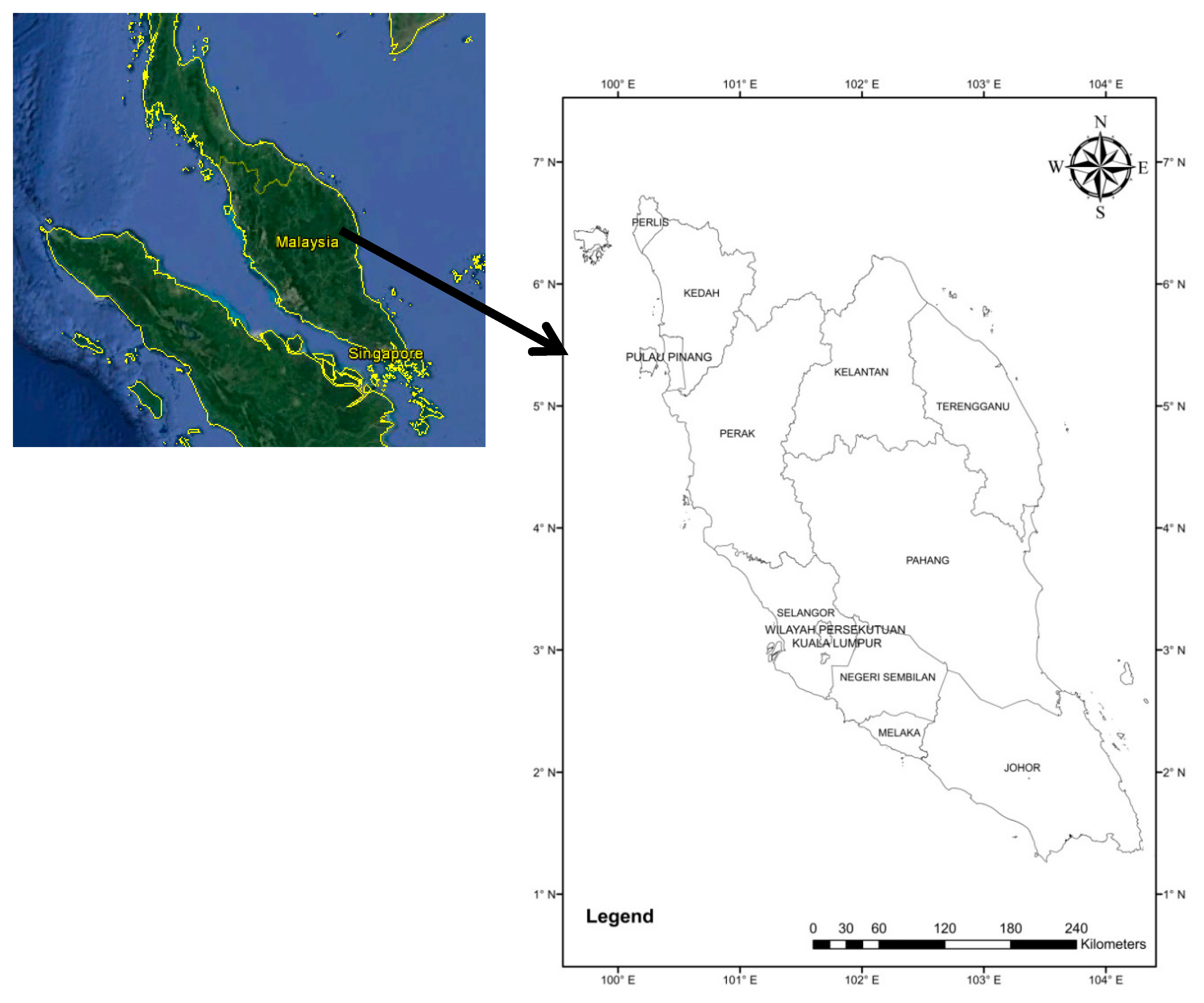
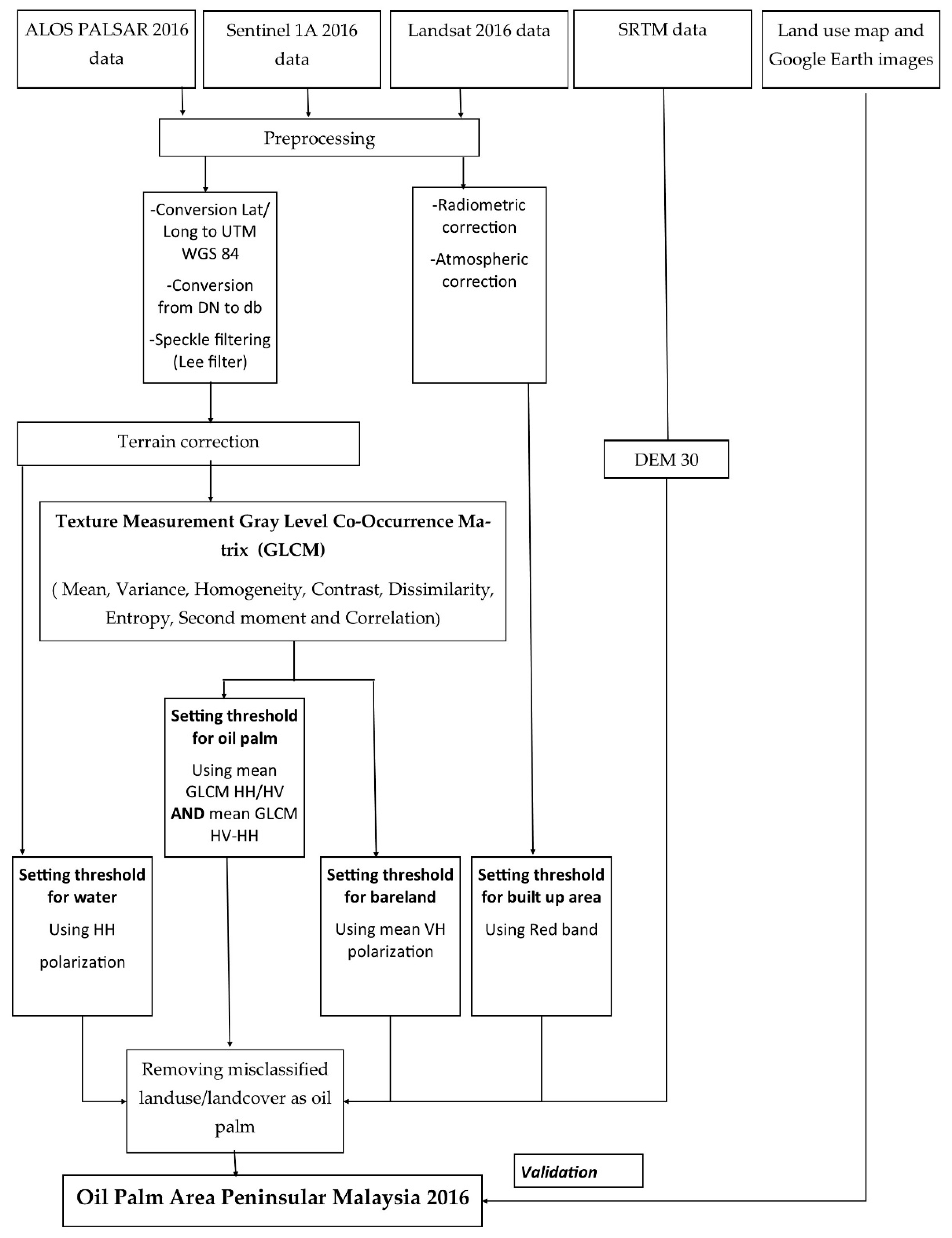
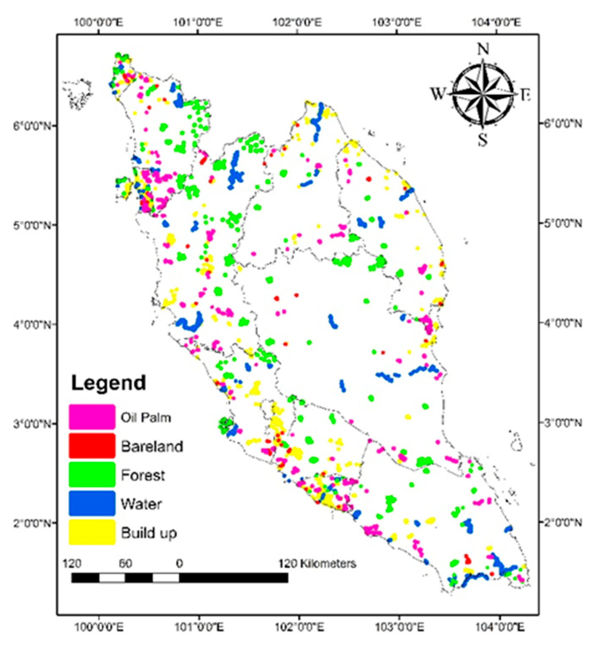
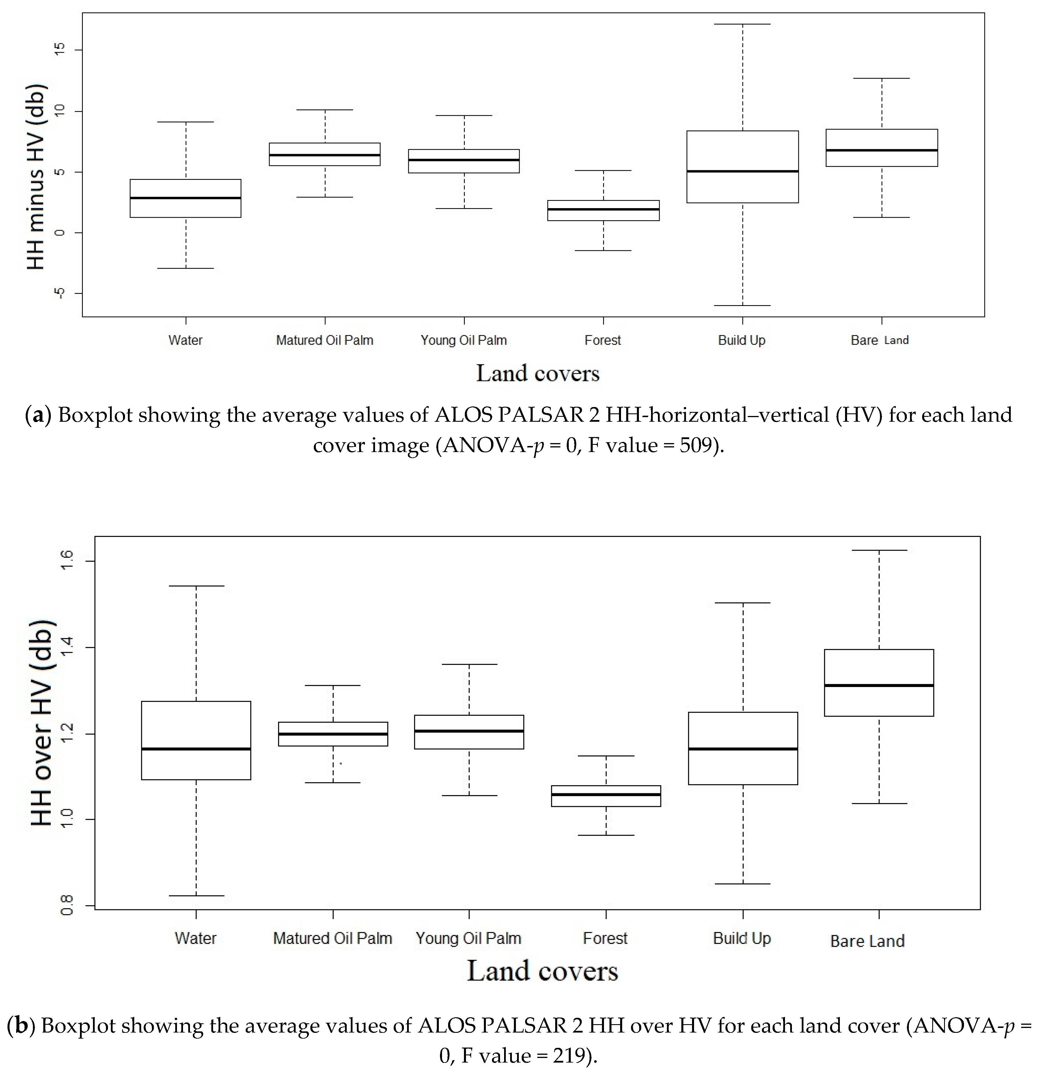


| No. | Data | Data Description | Satellites Characteristics |
|---|---|---|---|
| 1 | ALOS PALSAR 2 | L-band Dual polarization (HH and HV) 25 m × 25 m | Orbit properties: (a) Altitude: 691.65 km (at Equator) (b) Sun-synchronous (c) Repeat cycle: 46 days (d) Sub cycle: 2 days (e) Sensor modes: Fine (40 to 70 km), ScanSAR (250 to 350 km) and Polarimetric (20 to 65 km) http://www.eorc.jaxa.jp/ALOS/en/palsar_fnf/fnf_index.htm |
| 2 | Landsat 8 OLI | Multispectral band 30 m × 30 m | Orbit properties: (a) Altitude: 705 km (near-polar orbit) (b) Sun-synchronous (c) Repeat cycle: 16 days https://glovis.usgs.gov/ |
| 3 | Sentinel | C-band Level 1A 20 m × 22 m | Orbit properties: (a) Sun-synchronous (b) Wide swath (250 km) (c) Sensor modes: Stripmap, interferometric wide swath, extra wide swath, and wave https://vertex.daac.asf.alaska.edu/ |
| 4 | Shuttle radar topography mission (SRTM) | 30 m | http://dwtkns.com/srtm30m/ |
| 5 | Malaysian Palm Oil Board (MPOB) MPOB oil Palm plantation statistic | Area of oil plantation area in 2016 | http://bepi.mpob.gov.my/index.php/en/ |
| 6 | Land use map 2015 from Agriculture Department of Peninsular Malaysia | Land use data of Peninsular Malaysia | Agriculture Department of Peninsular Malaysia |
| Land Use | Oil Palm | Forest | Built Up | Bare Land | Water |
|---|---|---|---|---|---|
| No. of polygons | 1479 | 913 | 867 | 239 | 2197 |
| No. of pixels | 11,950 | 204,258 | 23,863 | 3769 | 83,908 |
| Land Cover | |||||
|---|---|---|---|---|---|
| Water | Matured Oil Palm | Young Oil Palm | Forest | Built Up | Bare Land |
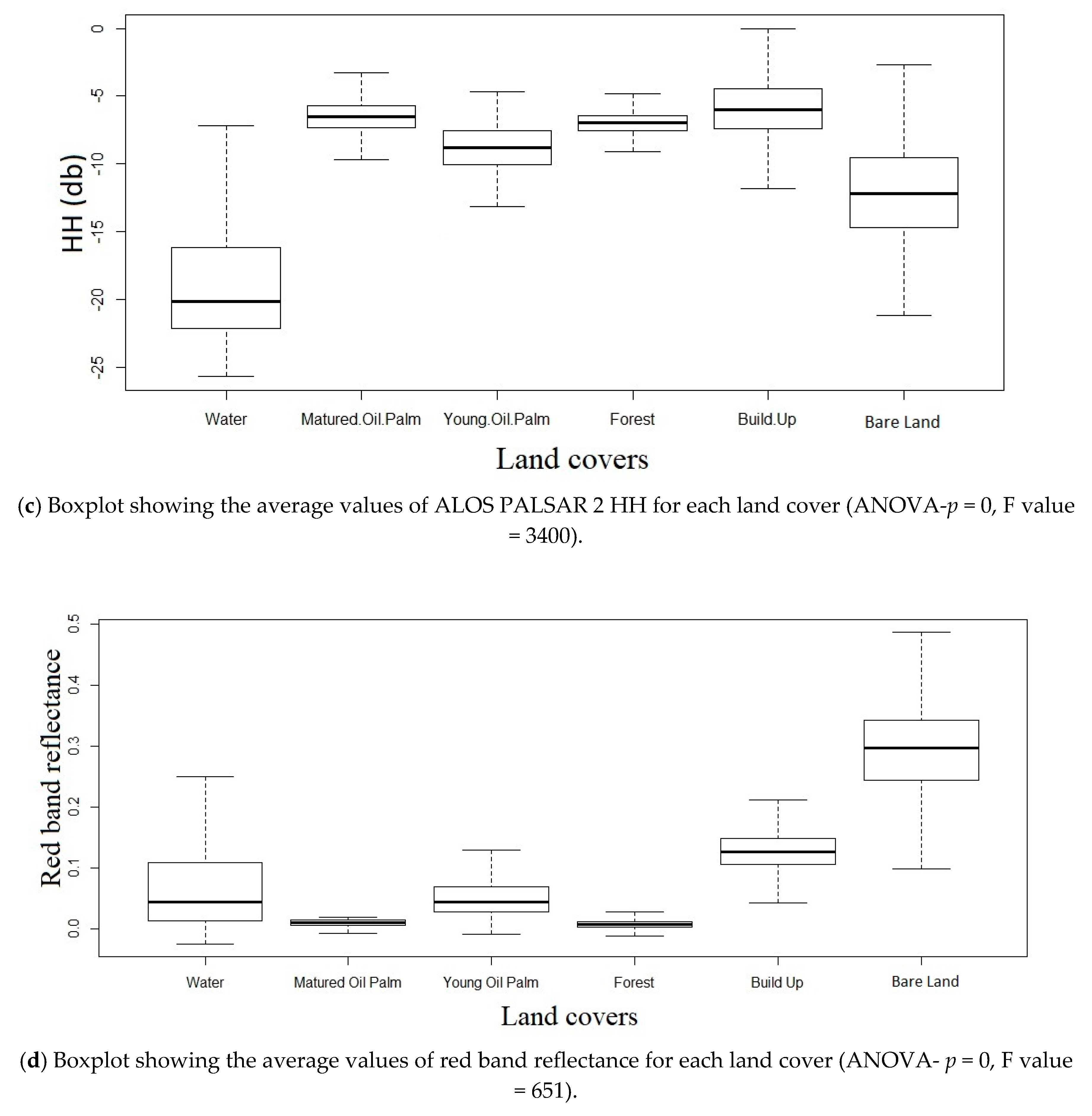
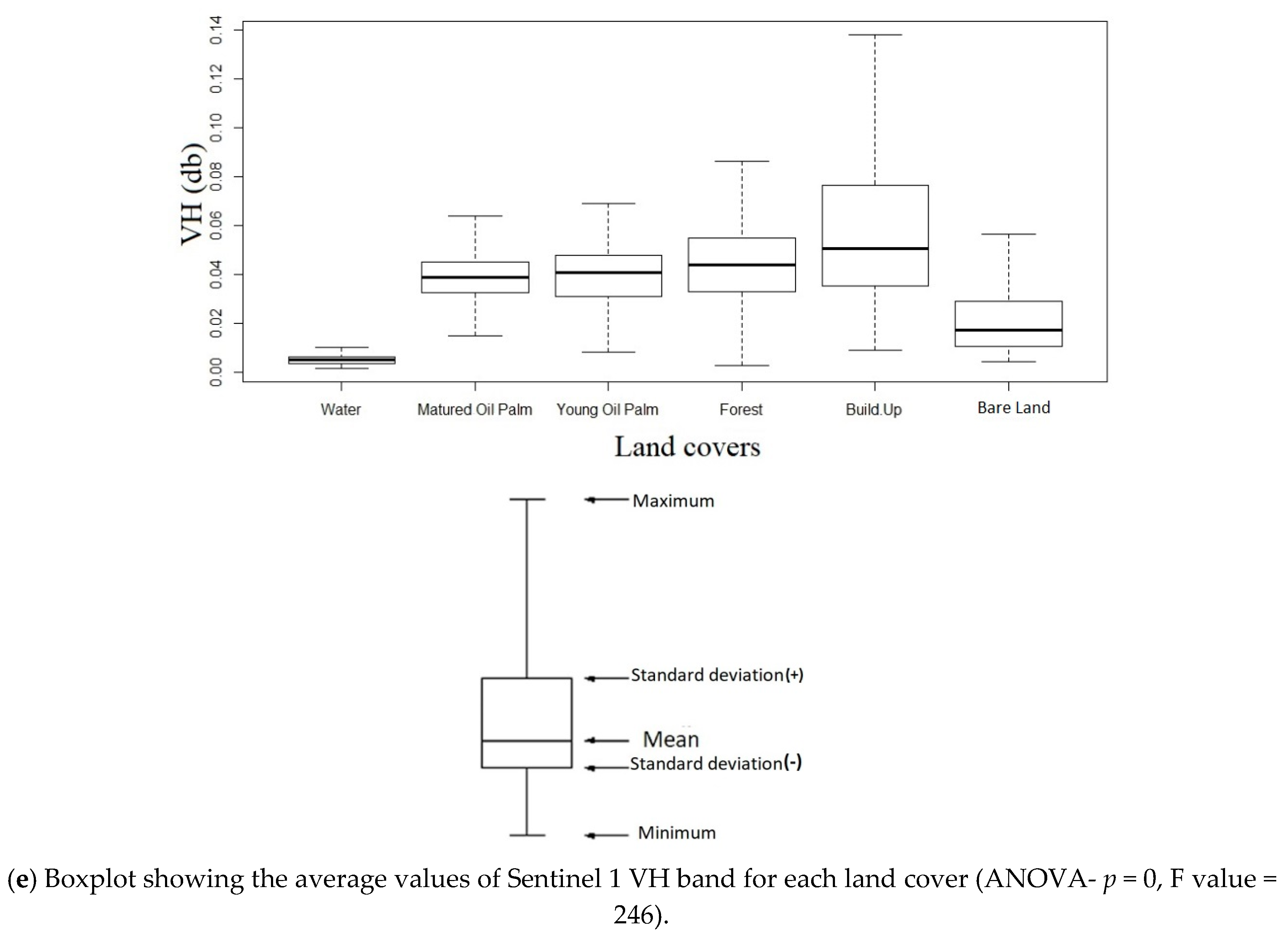
| −18.73 ± 4.59 | −6.53 ± 1.36 | −8.90 ± 1.76 | −7.04 ± 1.32 | −5.86 ± 2.70 | −12.10 ± 3.36 |
| Land use | Oil Palm | Oil Palm | Built Up | Bare Land | Water |
|---|---|---|---|---|---|
| (HH-HV) | (HH/HV) | (Band 3-Red Band) | (VH) | (HH) | |
| Threshold | >3.5 | >1.09 | >0.045 | >0.012 | <−10 |
| (a) | |||||
| Land Use | Oil Palm | Forest | Built Up | Bare Land | Water |
| Overall accuracy (%) | 83.27 | 97.71 | 61.93 | 64.35 | 60.63 |
| (b) | |||||
| Land Use | Oil Palm | Forest | Built Up | Bare Land | Water |
| Overall accuracy (%) | 98.36 | 98.97 | 88.46 | 85.27 | 96.50 |
| Classification | Oil Palm | Non-Oil Palm | Overall Accuracy (%) | Kappa Coefficient | ||
|---|---|---|---|---|---|---|
| Producer Accuracy (%) | User Accuracy (%) | Producer Accuracy (%) | User Accuracy (%) | |||
| Before removal | 80.23 | 17.45 | 83.38 | 99.11 | 83.27 | 0.21 |
| After removal | 81.79 | 76.1 | 99.01 | 99.29 | 98.36 | 0.78 |
| State | (1) This Study | (2) MOPB (2016) | (3) Cheng et al., 2019 [30] | Difference (1) and (2) | Difference (1) and (3) |
|---|---|---|---|---|---|
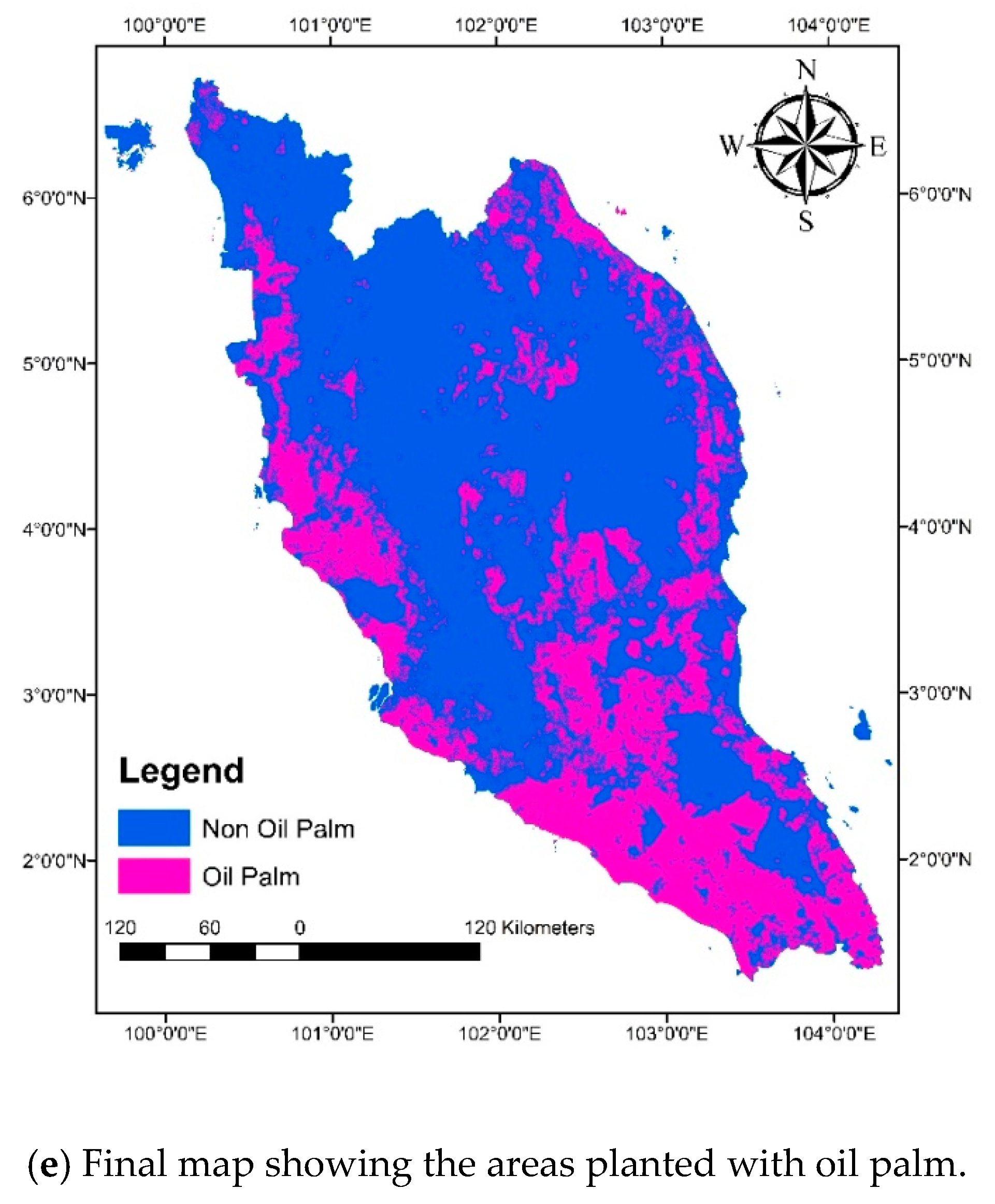
| Johor | 53.67 | 38.87 | 54.73 | 14.80 | −1.06 |
| Selangor | 15.08 | 17.42 | 31.37 | −2.35 | −16.29 |
| Perlis | 1.09 | 0.80 | 19.65 | 0.29 | −18.56 |
| Kedah | 8.21 | 9.27 | 20.06 | −1.05 | −11.85 |
| Perak | 17.65 | 18.96 | 25.73 | −1.31 | −8.08 |
| Kelantan | 10.44 | 10.32 | 15.27 | 0.12 | −4.83 |
| Pulau Pinang | 9.10 | 13.54 | 19.16 | −4.45 | −10.06 |
| Melaka | 50.41 | 33.85 | 42.20 | 16.56 | 8.21 |
| Pahang | 17.13 | 20.30 | 23.85 | −3.17 | −6.72 |
| Terengganu | 13.04 | 13.22 | 19.23 | −0.18 | −6.19 |
| Negeri Sembilan | 20.70 | 26.83 | 26.98 | −6.12 | −6.28 |
| Total | 20.99 | 20.27 | 27.61 | 0.72 | −6.62 |
| State | This Study | Cheng et al., 2019 [30] | Shaharum et al., (2020) [63] |
|---|---|---|---|
| Johor | 31.99 | 33.9 | 6.5 |
| Selangor | −14.43 | 57.18 | 35.28 |
| Perlis | 30.55 | 184.34 | 91.76 |
| Kedah | −12.07 | 73.59 | 51.18 |
| Perak | −7.17 | 30.3 | −3.49 |
| Kelantan | 1.11 | 38.68 | −22.59 |
| Pulau Pinang | −39.28 | 34.36 | −3.12 |
| Melaka | 39.32 | 21.96 | −22.5 |
| Pahang | −16.94 | 16.07 | −2.84 |
| Terengganu | −1.4 | 37 | −2.61 |
| Negeri Sembilan | −25.76 | 0.58 | −0.27 |
| Total | 3.48 | 30.67 | 3.16 |
© 2020 by the authors. Licensee MDPI, Basel, Switzerland. This article is an open access article distributed under the terms and conditions of the Creative Commons Attribution (CC BY) license (http://creativecommons.org/licenses/by/4.0/).
Share and Cite
Mohd Najib, N.E.; Kanniah, K.D.; Cracknell, A.P.; Yu, L. Synergy of Active and Passive Remote Sensing Data for Effective Mapping of Oil Palm Plantation in Malaysia. Forests 2020, 11, 858. https://doi.org/10.3390/f11080858
Mohd Najib NE, Kanniah KD, Cracknell AP, Yu L. Synergy of Active and Passive Remote Sensing Data for Effective Mapping of Oil Palm Plantation in Malaysia. Forests. 2020; 11(8):858. https://doi.org/10.3390/f11080858
Chicago/Turabian StyleMohd Najib, Nazarin Ezzaty, Kasturi Devi Kanniah, Arthur P. Cracknell, and Le Yu. 2020. "Synergy of Active and Passive Remote Sensing Data for Effective Mapping of Oil Palm Plantation in Malaysia" Forests 11, no. 8: 858. https://doi.org/10.3390/f11080858
APA StyleMohd Najib, N. E., Kanniah, K. D., Cracknell, A. P., & Yu, L. (2020). Synergy of Active and Passive Remote Sensing Data for Effective Mapping of Oil Palm Plantation in Malaysia. Forests, 11(8), 858. https://doi.org/10.3390/f11080858


