A Case Study Balancing Predetermined Targets and Real-World Constraints to Guide Optimum Urban Tree Canopy Cover for Perth, Western Australia


Abstract
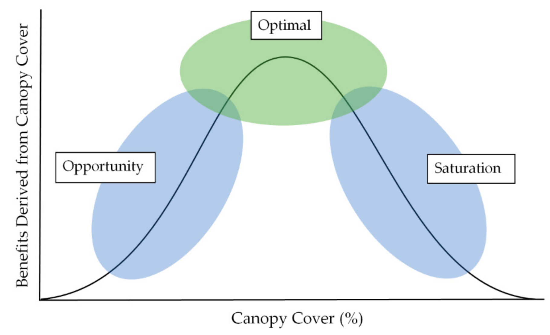
1. Introduction
- Foliage retention: the impact this may have on the relationship between this GI asset and local urban needs [31].
- Water dependance/drought tolerance: species demand on water and the variance within the urban forest [31].
- Species robustness: how species react to harsh and changing conditions and how this relates to urban center canopy needs [31].
- Interspecies interactions: competition within the urban forest that may impact the way in which canopy cover is pursued and managed [30].
- Invasive/weed species: the impact this may have on the productivity and impact of vegetation mass on an urban center [32].
2. Materials and Methods
2.1. Case Study Site
2.2. Determination of Factors Influencing Tree Canopy Cover
2.3. Tool Refinement by Focus Group
3. Factor Exploration and Confirmation
3.1. Determining Factors of Optimum Tree Canopy
3.1.1. Water Resource Availability
- Population growth predictions;
- Volume of water able to be abstracted that can support sustainable recovery;
- Water efficiency opportunities;
- Alternative water source options (i.e., desalination);
- Social behavior and values (i.e., unauthorized bore installation and usage).
3.1.2. Cost of Water
3.1.3. Soil Characteristics
3.1.4. Financial Investment
3.1.5. Community Desire
3.1.6. Shade Requirements
3.1.7. Biodiversity/Ecological Demand
3.1.8. Political Influence
3.1.9. Climate
3.1.10. Extreme Weather Events
3.1.11. Zoning
4. Results
4.1. Framework for Optimum Tree Canopy Assessment
4.2. Focus Group Enhancement of the Tool
4.3. Demonstration of the Tool
5. Discussion
5.1. Learnings of Case Study
5.2. Assumptions and Limitations of the Tool
- Foliage retention;
- Water dependance/drought tolerance;
- Species robustness;
- Interspecies interactions;
- Invasive/weed species.
5.3. Future Research
6. Conclusions
Supplementary Materials
Author Contributions
Funding
Acknowledgments
Conflicts of Interest
Appendix A

| Factor | Criteria | Assessment Structure | |||||
|---|---|---|---|---|---|---|---|
| Water Resource Availability | Major surplus of water for sustainable recovery (+110%) | Likert-Scale score 5 | |||||
| Minor surplus of water for sustainable recovery (+105%) | Likert-Scale score 4 | ||||||
| Adequate supply for sustainable recovery (100%) | Likert-Scale score 3 | ||||||
| Minor short fall of water for sustainable recovery (−95%) | Likert-Scale score 2 | ||||||
| Significant short fall of water for sustainable recovery (−90%) | Likert-Scale score 1 | ||||||
| Cost of Water | No cost—supported by rain only ($0 kL) | Likert-Scale score 5 | |||||
| Low ($0–$2 kL) | Likert-Scale score 4 | ||||||
| Medium ($2–$4 kL) | Likert-Scale score 3 | ||||||
| High ($4–$6 kL) | Likert-Scale score 2 | ||||||
| Extreme ($6+ kL) | Likert-Scale score 1 | ||||||
| Soil Characteristics (high CEC, water holding capacity, free draining, good aeration) | Very high in all desired factors | Likert-Scale score 5 | |||||
| High in all desired factors | Likert-Scale score 4 | ||||||
| Moderate in all desired factors | Likert-Scale score 3 | ||||||
| Low in all desired factors | Likert-Scale score 2 | ||||||
| Very Low in all desired factors | Likert-Scale score 1 | ||||||
| Financial Investment | Very high investment ($/100 m2 $1200–$1500) | Likert-Scale score 5 | |||||
| High investment ($/100 m2 $900–$1200) | Likert-Scale score 4 | ||||||
| Moderate investment ($/100 m2 $600–$900) | Likert-Scale score 3 | ||||||
| Low investment ($/100 m2 $300–$600) | Likert-Scale score 2 | ||||||
| Little to no investment ($/100 m2 $0–$300) | Likert-Scale score 1 | ||||||
| Community Desire | Strong desire | Likert-Scale score 5 | |||||
| Mild desire | Likert-Scale score 4 | ||||||
| Neutral | Likert-Scale score 3 | ||||||
| Mild opposition | Likert-Scale score 2 | ||||||
| Strong opposition | Likert-Scale score 1 | ||||||
| Shade Requirements (High foot traffic, high car traffic, wide road, wider verge, orientation E/W, low infrastructure) | Very high (7–8 factors present) | Likert-Scale score 5 | |||||
| High (5–6 factors present) | Likert-Scale score 4 | ||||||
| Medium (3–4 factors present) | Likert-Scale score 3 | ||||||
| Low (1–2 factors present) | Likert-Scale score 2 | ||||||
| None (0 factors present) | Likert-Scale score 1 | ||||||
| Biodiversity/Ecological Demand | Within a biodiversity hotspot | Likert-Scale score 5 | |||||
| High biodiversity | Likert-Scale score 4 | ||||||
| Moderate diversity | Likert-Scale score 3 | ||||||
| Low diversity | Likert-Scale score 2 | ||||||
| Void of biodiversity | Likert-Scale score 1 | ||||||
| Political Influence | 5 × 5 grid | very strong support | neutral | strong opposition | very strong opposition | neutral | |
| very strong influence | 5 | 4 | 3 | 2 | 1 | ||
| strong influence | 4 | 4 | 3 | 2 | 1 | ||
| moderate influence | 3 | 3 | 3 | 2 | 1 | ||
| weak influence | 2 | 2 | 2 | 2 | 1 | ||
| no influence | 1 | 1 | 1 | 1 | 1 | ||
| Climate | Tropical | Likert-Scale score 5 | |||||
| Mediterranean | Likert-Scale score 4 | ||||||
| Temperate | Likert-Scale score 3 | ||||||
| Arid | Likert-Scale score 2 | ||||||
| Mountains | Likert-Scale score 1 | ||||||
| Extreme Weather Events (heavy rainfall, localised flooding, extreme temperatures, strong winds) | 5 × 5 grid | 10+ times per year | 7 to 9 | 4 to 6 | 1 to 3 | never | |
| Experiences all extreme weather events | 5 | 4 | 3 | 2 | 1 | ||
| Experiences most extreme weather events | 4 | 4 | 3 | 2 | 1 | ||
| Experiences some extreme weather events | 3 | 3 | 3 | 2 | 1 | ||
| Experiences | 2 | 2 | 2 | 2 | 1 | ||
| Experiences none extreme weather events | 1 | 1 | 1 | 1 | 1 | ||
| Zoning | CBD | Likert-Scale score 5 | |||||
| Inner city | Likert-Scale score 4 | ||||||
| Metropolitan | Likert-Scale score 3 | ||||||
| Outer metropolitan | Likert-Scale score 2 | ||||||
| Semi-rural | Likert-Scale score 1 | ||||||
References
- Roloff, A. Urban Tree Management: For the Sustainable Development of Green Cities; Wiley Blackwell: Hoboken, NJ, USA, 2016. [Google Scholar]
- Liu, L.; Sun, L.; Niu, J.; Riley, W.J. Modeling green roof potential to mitigate urban flooding in a Chinese city. Water 2020, 12, 2082. [Google Scholar] [CrossRef]
- Santamouris, M. Using cool pavements as a mitigation strategy to fight urban heat island—A review of the actual development. Renew. Sustain. Energy Rev. 2013, 26, 224–240. [Google Scholar] [CrossRef]
- Wenga, Q.; Lub, D.; Schubringa, J. Estimation of land surface temperature-vegetation abundance relationship for urban heat island studies. Remote Sens. Environ. 2004, 89, 467–483. [Google Scholar] [CrossRef]
- Brown, K.; Spickett, C. Cool Communities: Urban Trees, Climate and Health; Curtin University: Perth, Australia, 2013; Available online: http://ehia.curtin.edu.au/projects/climatechange.cfm (accessed on 14 April 2019).
- Bun, M.; Jones, R.; Lorimer, C.; Pitman, S.; Thorpe, R. The 202020 Vision Plan. Australas. Parks Leis. 2015, 18, 42–43. [Google Scholar] [CrossRef]
- Burgeon, D.; Hofer, T.; van Lierop, P.; Wabbes, S. Trees and forests—Lifelines for resilience. Unasylva 2015, 243, 86–89. [Google Scholar]
- Parker, J.; de Baro, M.E.Z. Green infrastructure in the urban environment: A quantitative literature review. Sustainability 2019, 11, 3182. [Google Scholar] [CrossRef]
- Parker, J.; Simpson, G.D. A theoretical framework for bolstering human-nature connections and urban resilience via green infrastructure. Land 2020, 9, 252. [Google Scholar] [CrossRef]
- Cattell, V.; Dines, N.; Gesler, W.; Curtis, S. Mingling, observing, and lingering: Everyday public spaces and their implications for well-being and social relations. Health Place 2008, 14, 544–561. [Google Scholar] [CrossRef] [PubMed]
- Ashley, R.M.; Nowell, R.; Gersonius, B.; Walker, L. Surface Water Management and Urban Green Infrastructure: A Review of Potential Benefits and UK and International Practices; Foundation for Water Research: Buckinghamshire, UK, May 2011. [Google Scholar]
- Foster, J.; Lowe, A.; Winkelman, S. The Value of Green Infrastructure for Urban Climate Adaptation; Centre for Clean Air Policy: Washington, DC, USA, 2011; Available online: http://ccap.org/assets/The-Value-of-Green-Infrastructure-for-Urban-Climate-Adaptation_CCAP-Feb2011.pdf (accessed on 9 May 2020).
- Norton, B.A.; Coutts, A.M.; Livesley, S.J.; Harris, R.J.; Hunter, A.M.; Williams, N.S. Planning for cooler cities: A framework to prioritise green infrastructure to mitigate high temperatures in urban landscapes. Landsc. Urban Plan. 2015, 134, 127–138. [Google Scholar] [CrossRef]
- Burden, D. Urban Street Trees: 22 Benefits. Available online: www.walkable.org/download/22_benefits.pdf (accessed on 12 May 2020).
- Bratman, G.N.; Hamilton, P.; Daily, G.C. The impacts of nature experience on cognitive function and mental health. N. Y. Acad. Sci. 2012, 1249, 118–136. [Google Scholar] [CrossRef]
- Keniger, L.E.; Gaston, K.J.; Irvine, K.N.; Fuller, R.A. What are the benefits of interacting with nature? Int. J. Environ. Res. Public Health 2013, 10, 913–935. [Google Scholar] [CrossRef] [PubMed]
- Christian, H.; Lester, L.; Trost, S.G.; Trapp, G.; Schipperijn, J.; Boruff, B.; Eslick, H. Shade coverage, ultraviolet radiation and children’s physical activity in early childhood education and care. Int. J. Public Health 2019, 64, 1325–1333. [Google Scholar] [CrossRef] [PubMed]
- Li, W. Understand the Social Impact of Green—Evaluation on the Impacts of Urban Vegetation on Neighbourhood Crime; University of California: Los Angeles, CA, USA, 2008. [Google Scholar]
- Holtan, M.T.; Dieterlen, S.L.; Sullivan, W.C. Social life under cover: Tree canopy and social capital in Baltimore, Maryland. Environ. Behav. 2015, 47, 502–525. [Google Scholar] [CrossRef]
- Conteh, F.M.; Oktay, D. Measuring liveability by exploring urban qualities of Kissy Street, Freetown, Sierra Leone. Open House Int. 2016, 41, 23–30. [Google Scholar] [CrossRef]
- Whitehouse, A. Common economic oversights in green infrastructure valuation. Landsc. Res. 2017, 42, 230–234. [Google Scholar] [CrossRef]
- Pandit, R.; Polyakov, M.; Tapsuwan, S.; Moran, T. The effect of street trees on property value in Perth, Western Australia. Landsc. Urban Plan. 2013, 110, 134–142. [Google Scholar] [CrossRef]
- Sander, H.; Polasky, S.; Haight, R.G. The value of urban tree cover: A hedonic property price model in ramsey and dakota counties, minnesota, USA. Ecol. Econ. 2010, 69, 1646–1656. [Google Scholar] [CrossRef]
- Bradford, A.; Pappas, S.; Effect of Global Warming. Live Science. Available online: www.livescience.com/37057-global-warming-effects.html (accessed on 20 June 2020).
- Pappas, S. What Is Global Warming? Available online: https://www.livescience.com/37003-global-warming.html (accessed on 20 June 2020).
- Tzoulas, K.; Korpela, K.; Venn, S.; Yli-Pelkonen, V.; Kaźmierczak, A.; Niemela, J.; James, P. Promoting ecosystem and human health in urban areas using green infrastructure: A literature review. Landsc. Urban Plan. 2007, 81, 167–178. [Google Scholar] [CrossRef]
- Harlan, S.L.; Brazela, A.J.; Prashada, L.; Stefanovb, W.L.; Larsenc, L. Neighbourhood microclimates and vulnerability to heat stress. Soc. Sci. Med. 2006, 63, 2847–2863. [Google Scholar] [CrossRef]
- McGovern, M.; Pasher, J. Canadian urban tree canopy cover and carbon sequestration status and change 1990–2012. Urban For. Urban Green. 2016, 20, 227–232. [Google Scholar] [CrossRef]
- Zarr, R.; Conway, T. What about the trees? Trees as nature-based “shade sails”. Am. J. Public Health 2017, 107, 1876–1877. [Google Scholar] [CrossRef] [PubMed]
- Fineschi, S.; Loreto, F. A survey of multiple interactons between plants and the urban environment. Front. For. Glob. Chang. 2020, 3, 1–19. [Google Scholar] [CrossRef]
- Vuidot, A.; Paillet, Y.; Archaux, F.; Gosselin, F. Influence of tree characteristics and forest management on tree microhabitats. Biol. Conserv. 2011, 144, 441–450. [Google Scholar] [CrossRef]
- Rajmanek, M.; Richardson, D.M. Trees and shrubs as invasive alien species—2013 update of the global database. Divers. Distrib. 2013, 19, 1093–1094. [Google Scholar] [CrossRef]
- Schwarz, K.; Fragkias, M.; Boone, C.G.; Zhou, W.; Grove, J.M.; Cadnasso, M.L. Trees grow on money: Urban tree canopy cover and environmental justice. PLoS ONE 2015, 10. [Google Scholar] [CrossRef] [PubMed]
- Ambrey, C.; Byrne, J.; Matthews, T.; Davison, A.; Portanger, C.; Lo, A. Cultivating climate justice: Green infrastructure and suburban disadvantage in Australia. Appl. Geogr. 2017, 89, 52–60. [Google Scholar] [CrossRef]
- Parker, J. A Survey of Park User Perception in the Context of Green Space and City Liveability: Lake Claremont, Western Australia. Master’s Thesis, Murdoch University, Perth, Australia, 2017. Available online: http://researchrepository.murdoch.edu.au/id/eprint/40856/ (accessed on 14 June 2019).
- McKim, C.A. The value of mixed methods research: A mixed methods study. J. Mix. Methods Res. 2017, 11, 202–222. [Google Scholar] [CrossRef]
- Temple University 2020a Review Types: Scoping Review. Available online: https://guides.temple.edu/c.php?g=78618&p=4156607 (accessed on 12 April 2020).
- Temple University 2020b Review Types: Rapid Review. Available online: https://guides.temple.edu/c.php?g=78618&p=4156608 (accessed on 12 April 2020).
- Krueger, R.A.; Casey, M.A. Focus Groups: A Practical Guide for Applied Research, 3rd ed.; Sage Publications: Thousand Oaks, CA, USA, 2000. [Google Scholar]
- Warr, D.J. “It was fun but we don’t usually talk about these things”: Analyzing sociable interaction in focus groups. Qual. Inq. 2005, 11, 200–225. [Google Scholar] [CrossRef]
- Nassar-McMillan, S.C.; Borders, L.D. Use of focus groups in survey item development. Qual. Rep. 2002, 7, 1–12. [Google Scholar]
- Kitzinger, J.; Barbour, R.S. Introduction: The challenge and promise of focus groups. In Developing Focus Group Research: Politics, Theory and Practice; Sage: London, UK, 2005; pp. 1–20. [Google Scholar]
- Kieffer, E.C.; Salabarria-Pena, Y.; Odoms-Young, A.M.; Willis, S.K.; Baber, K.E.; Guzman, J.R. The application of focus group methodologies to community-based participatory research. In Methods in Community-Based Participatory Research for Health; Jossey-Bass: San Francisco, CA, USA, 2005; pp. 146–166. [Google Scholar]
- Renouf, M.A.; Serrao-Neumann, S.; Kenway, S.J.; Morgan, E.A.; Low Choy, D. Urban water metabolism indicators derived from a water mass balance—Bridging the gap between vision and performance assessment of urban water resource management. Water Res. 2017, 122, 669–677. [Google Scholar] [CrossRef]
- Productivity Commission Issues Paper: Australia’s Urban Water Sector Submission from the Department of Water (Western Australia). Available online: https://www.pc.gov.au/inquiries/completed/urban-water/submissions/sub038.pdf (accessed on 10 April 2019).
- Australian Water Association: Desaliniation. Available online: http://www.awa.asn.au/AWA_MBRR/Publications/Fact_Sheets/Desalination_Fact_Sheet.aspx (accessed on 10 April 2019).
- Karamouz, M.; Yaseri, K.; Nazif, S. Reliability-based assessment of lifecycle cost of urban water distribution infrastructures. J. Infrastruct. Syst. 2017, 23. [Google Scholar] [CrossRef]
- Cogliastro, A.; Gagnon, D.; Bouchard, A. Experimental determination of soil characteristics optimal for the growth of ten hardwoods planted on abandoned farmland. For. Ecol. Manag. 1997, 96, 49–63. [Google Scholar] [CrossRef]
- Stolt, P.A.; Christidis, N.; Otto, F.E.L.; Sun, Y.; Vanderlinden, J.; van Oldenborgh, G.J.; Zwiers, F.W. Attribution of extreme weather and climate-related events. Wiley Interdiscip. Rev. Clim. Chang. 2016, 7, 23–41. [Google Scholar] [CrossRef]
- Intergovernmental Panel on Climate Change (IPCC). Climate Change 2014: Synthesis Report. Contribution of Working Groups I, II and III to the Fifth Assessment Report of the Intergovernmental Panel on Climate Change; Core Writing Team, Pachauri, R.K., Meyer, L.A., Eds.; IPCC: Geneva, Switzerland, 2014; p. 151. [Google Scholar]
- Government of Western Australian. Department of Planning, Lands and Heritage. SPP 7.3 Residential design Codes—Volume 1. Available online: https://www.dplh.wa.gov.au/rcodes (accessed on 28 June 2019).
- Sullivan, G.M.; Artino, A.R. Analyzing and interpreting data from likert-type scales. J. Grad. Med. Educ. 2013, 5, 541–542. [Google Scholar] [CrossRef]


| Participant No. | Capacity of Participation | Field of Expertise | Length of Experience (Years) |
|---|---|---|---|
| 1 | Professional Practitioner | Arboriculture | 30+ |
| 2 | Professional Practitioner | Arboriculture | 10+ |
| 3 | Elected Community Representative | Local Government Councilor | 10+ |
| 4 | Professional Practitioner | Public Open Space Management | 30+ |
| 5 | Professional Practitioner | Environmental Management | 25+ |
| 6 | Professional Practitioner | Planning and Development | 25+ |
| 7 | Community Stakeholder | Community Environmental Volunteer | 15+ |
| 8 | Community Stakeholder | Community Environmental Volunteer | 15+ |
| 9 | Community Stakeholder | Community Environmental Volunteer | 20+ |
| 10 | Professional Practitioner | Urban Sustainability and Green Space Management | 20+ |
| 11 | Elected Community Representative | Local Government Councilor | 10+ |
| 12 | Academic | Biophilic Green Architecture | 15+ |
| 13 | Professional Practitioner | Engineer | 15+ |
| 14 | Professional Practitioner | Urban Planning | 5+ |
| 15 | Academic | Urban Ecology and Sustainability | 10+ |
| Aspect | Question |
|---|---|
| 1 | Based on the background information provided, do you have questions about the application and quantification of the factor? |
| 2 | Based on the background information provided, do you have questions about the measurement criteria of the factor? |
| 3 | Do you think this factor is important in determining optimum canopy cover? |
| 5 | Do you have any suggestions to enhance the contribution of the factor within the canopy cover tool? |
| Factor | Scale | Criteria |
|---|---|---|
| Water Resource Availability | five-point Likert Scale | Major surplus of water for sustainable recovery (+110%) |
| Minor surplus of water for sustainable recovery (+105%) | ||
| Adequate supply for sustainable recovery (100%) | ||
| Minor short fall of water for sustainable recovery (−95%) | ||
| Cost of Water | five-point Likert Scale | No cost—supported by rain only ($0 kL) |
| Low ($0–$2 kL) | ||
| Medium ($2–$4 kL) | ||
| High ($4–$6 kL) | ||
| Soil Characteristics | five-point Likert Scale | Very high in all desired factors |
| High in all desired factors | ||
| Moderate in all desired factors | ||
| Low in all desired factors | ||
| Very low in all desired factors | ||
| Financial Investment | five-point Likert Scale | Very high investment ($) |
| High investment | ||
| Moderate investment | ||
| Low investment | ||
| Little to no investment | ||
| Community Desire | five-point Likert Scale | Strong desire |
| Mild desire | ||
| Neutral | ||
| Mild opposition | ||
| Strong opposition | ||
| Shade Requirements | five-point Likert Scale | Very high (7–8 factors present) |
| High (5–6 factors present) | ||
| Medium (3–4 factors present) | ||
| Low (1–2 factors present) | ||
| None (0 factors present) | ||
| Biodiversity/Ecological Demand | five-point Likert Scale | Within a biodiversity hotspot |
| High biodiversity | ||
| Moderate diversity | ||
| Low diversity | ||
| Void of biodiversity | ||
| Political Influence | five-point Likert Scale | 5 × 5 grid |
| Climate | five-point Likert Scale | Tropical |
| Mediterranean | ||
| Temperate | ||
| Arid | ||
| Mountains | ||
| Extreme Weather Events | five-point Likert Scale | 5 × 5 grid |
| Zoning | five-point Likert Scale | CBD |
| Inner city | ||
| Metropolitan | ||
| Outer metropolitan | ||
| Semi-rural |
| Factor | Participant Confidence Measurement (Pre-Focus Group) | Participant Confidence Measurement (Post-Focus Group) | Net Difference |
|---|---|---|---|
| Water Resource Availability | 7.6 (n = 13) | 8.4 (n = 10) | 0.8 |
| Cost of Water | 6.9 (n = 13) | 8.5 (n = 10) | 1.6 |
| Soil Characteristics | 8.0 (n = 14) | 8.5 (n = 10) | 0.5 |
| Financial Investment | 7.4 (n = 13) | 7.8 (n = 10) | 0.4 |
| Community Desire | 7.9 (n = 14) | 7.8 (n = 10) | −0.1 |
| Shade Requirements | 8.3 (n = 14) | 8.8 (n = 10) | 0.5 |
| Biodiversity/Ecological Demand | 7.6 (n = 13) | 7.5 (n = 10) | −0.1 |
| Political Influence | 6.3 (n = 13) | 7.0 (n = 10) | 0.7 |
| Climate | 7.9 (n = 13) | 8.2 (n = 10) | 0.3 |
| Extreme Weather Events | 6.5 (n = 13) | 6.2 (n = 10) | −0.3 |
| Zoning | 7.4 (n = 13) | 7.7 (n = 10) | 0.3 |
| Factor | Strong Relationship (Value = 0.3) | Moderate Relationship (Value = 0.2) | Weak Relationship (Value = 0.1) | Mean Result (∑nV/∑n) | Assigned Factor Weighting |
|---|---|---|---|---|---|
| Water Resource Availability | n = 9 | n = 5 | n = 0 | 0.26 | 0.3 Strong |
| Cost of Water | n = 7 | n = 6 | n = 0 | 0.25 | 0.3 Strong |
| Soil Characteristics | n = 6 | n = 4 | n = 3 | 0.22 | 0.2 Moderate |
| Financial Investment | n = 6 | n = 7 | n = 1 | 0.24 | 0.2 Moderate |
| Community Desire | n = 8 | n = 6 | n = 0 | 0.26 | 0.3 Strong |
| Shade Requirements | n = 9 | n = 4 | n = 0 | 0.27 | 0.3 Strong |
| Biodiversity/Ecological Demand | n = 6 | n = 4 | n = 4 | 0.19 | 0.2 Moderate |
| Political Influence | n = 7 | n = 4 | n = 4 | 0.22 | 0.2 Moderate |
| Climate | n = 9 | n = 3 | n = 1 | 0.26 | 0.3 Strong |
| Extreme Weather Events | n = 2 | n = 8 | n = 1 | 0.21 | 0.2 Moderate |
| Zoning | n = 6 | n = 5 | n = 2 | 0.23 | 0.2 Moderate |
Publisher’s Note: MDPI stays neutral with regard to jurisdictional claims in published maps and institutional affiliations. |
© 2020 by the authors. Licensee MDPI, Basel, Switzerland. This article is an open access article distributed under the terms and conditions of the Creative Commons Attribution (CC BY) license (http://creativecommons.org/licenses/by/4.0/).
Share and Cite
Parker, J.; Simpson, G.D. A Case Study Balancing Predetermined Targets and Real-World Constraints to Guide Optimum Urban Tree Canopy Cover for Perth, Western Australia. Forests 2020, 11, 1128. https://doi.org/10.3390/f11111128
Parker J, Simpson GD. A Case Study Balancing Predetermined Targets and Real-World Constraints to Guide Optimum Urban Tree Canopy Cover for Perth, Western Australia. Forests. 2020; 11(11):1128. https://doi.org/10.3390/f11111128
Chicago/Turabian StyleParker, Jackie, and Greg D. Simpson. 2020. "A Case Study Balancing Predetermined Targets and Real-World Constraints to Guide Optimum Urban Tree Canopy Cover for Perth, Western Australia" Forests 11, no. 11: 1128. https://doi.org/10.3390/f11111128
APA StyleParker, J., & Simpson, G. D. (2020). A Case Study Balancing Predetermined Targets and Real-World Constraints to Guide Optimum Urban Tree Canopy Cover for Perth, Western Australia. Forests, 11(11), 1128. https://doi.org/10.3390/f11111128