Article

Wildfire Alters Spatial Patterns of Available Soil Nitrogen and Understory Environments in a Valley Boreal Larch Forest

1
College of Life Sciences, Shenyang Normal University, Shenyang 110034, China
2
Department of Forestry, TP Cooper Building, University of Kentucky, Lexington, KY 40546, USA
3
CAS Key Laboratory of Forest Ecology and Management, Institute of Applied Ecology, Chinese Academy of Sciences, Shenyang 110016, China
*
Author to whom correspondence should be addressed.
Forests 2019, 10(2), 95; https://doi.org/10.3390/f10020095
Submission received: 22 November 2018 / Revised: 6 January 2019 / Accepted: 15 January 2019 / Published: 25 January 2019
(This article belongs to the Special Issue Fire Effects and Management in Forests)

Abstract

:
Wildfire, a primary natural disturbance in many forests, affects soil nutrient availability and spatial distributions of forest plants. However, post-fire changes in soil nutrients and spatial patterns of understory environments at fine scales are poorly understood. Here, we characterized spatial patterns of soil nitrogen availability and site characteristics at a 3-year-post-fire and an unburned site in a valley boreal larch forest. We also examined the relationship between soil nitrogen availability and site characteristics. The results showed that the burned site had higher NO3 and lower NH4+ than the control. The herb, litter and coarse wood debris cover was greater at the burned site than at the control site with higher soil pH, depth of the organic horizon (DOH) and shrub cover. Relative variability (coefficient of variation) in soil nitrogen and site characteristic variables at the control site was greater than at the burned site except for shrub and regeneration tree seedling cover. Spatial structure (quantified by semi-variograms) was lacking for soil nitrogen and site characteristic variables except for DOH, herb and shrub cover at the control site, but wildfire created a strong spatial structure for all variables. Shorter spatial autocorrelation ranges of soil nitrogen (1.6–3.5 m) and site characteristic variables (2.6–6.0 m) were detected at the burned site, indicating higher heterogeneity. The spatial scale of soil NH4+ was congruent with those of herb, shrub and regeneration tree seedling cover, indicating local coupling, while that of soil NO3 was not. The number of correlations between soil nitrogen and site characteristic variables in the burned site was greater than in the control. These results indicate that fire could not only create higher heterogeneity patches of soil resources, but also strengthen the local coupling between soil resources and understory vegetation, which may impact the establishment and growth of new individual plants.

Graphical Abstract

1. Introduction

The heterogeneity of soil resources plays an important role in sustaining the structure and functioning of forest ecosystems [1,2,3], as such heterogeneity can impact the survival of colonizing individual vegetation species and thus the biodiversity of vegetation communities [4,5]. Plants can also impact the spatial pattern of soil resources by altering physical, chemical and biological soil properties [6,7,8]. However, recent studies have found that these interactions and the potential heterogeneity across landscapes could be modified by disturbances [9,10,11]. Wildfire is one of the most important natural ecological disturbance agents in forest ecosystems, is characterized by variations in fire severity and frequency [12,13], and therefore produces spatial and temporal variations in ecological systems. Fire frequency and severity have been predicted to increase under a warming climate [14]; thus, understanding changes in patterns of post-fire soil resources and plants across space is necessary to better understand the ecological effects of fires in fire-prone ecosystems.
Nitrogen (N) often limits primary production in boreal forests due to lower N availability caused by slow decomposition rates [15], and its biogeochemical processes are the most vulnerable to fires due to its low volatilization temperature [16,17]. Fires can immediately affect the distribution and mass of N in ecosystems through pyrolysis, volatilization, and ash deposition [18,19]. Consequently, fires decrease soil N pools, but increase N availability, and further influence N transformations [20,21,22,23,24]. These studies have well-documented fire impacts on soil N cycling at coarse scales. In contrast, only a small number of studies about the fine-scale spatial variation in N availability following a wildfire have been performed, but these studies yielded some inconsistent results, with increases [11,25], decreases [26] and no changes [7] in spatial heterogeneity in different forest stands after fire. However, data for boreal larch forests that are dominated by surface fires are scarce. Mature larch trees are fire-resistant with shallow root systems and larch forests have a thick forest floor layer (>20 cm in the valley bottom) due to the refractory nature of litter and the accumulation of moss and lichens [27]. In such environments, wildfires can produce high heterogeneity in soil resources due to differences in fuel load, fuel moisture, and downed wood after fire at microsites. Some microsites with relatively high soil resources can provide advantages to new recruits since plant roots can recognize spatial heterogeneity in soil resources at fine scales (e.g., 2 m); thus, such differences in root uptake affinity affect species distributions at fine scales [28,29]. Therefore, characterizing spatial variation in soil N availability after fire could contribute to determining the nature of the plant–soil interaction and better guiding forest managers to preform post-fire vegetation restoration work.
The heterogeneity of soil N availability after fire may be associated with variations in residual soil characteristics (e.g., soil water, pH and depth of the organic horizon), variations in fire severity (e.g., the rate of vegetation mortality, residual soil organic horizon after fire and ash deposition), and variations in aboveground cover (e.g., understory vegetation, litter and coarse wood debris) [7,30], as these factors control nitrogen cycling. Fire severity is an important factor affecting soil processes and vegetation due to its direct effects on soil characteristics and indirect effects on plant species composition and distribution [18,31,32]. Severe burning can completely kill mature trees and consume understory vegetation and organic soil horizons [31], thus creating uniform understory environments. In contrast, low to moderate burning may produce high heterogeneity in soil characteristics and understory cover because parts of the organic soil horizon and some plants are preserved after the fire [32,33]. Fire-caused variations in soil resources and vegetation are likely to impact the establishment and survival of regeneration plants [11,34,35], and N availability levels may influence the spacing of individual plants or the distribution of plant types across landscapes [36]. Despite increasing recognition of the plant–soil interaction after fire across space, limited studies have been conducted to identify the factors controlling spatial heterogeneity in soil N post fire, which is probably vital for understanding the mechanisms of regulating ecosystem structure and functioning. Therefore, studying variations in factors controlling available soil N contents at fine scales may contribute to elucidating fire effects on N cycle processes at multiple spatial scales.
We expected that wildfire could influence the spatial heterogeneity of soil N variables, understory vegetation cover and soil resources. We also hypothesized a tighter correlation between soil resources and understory vegetation due to decreases in the depth of soil organic horizons in the post-fire early succession stage. Previous studies indicated that the spatial patterns of post-fire plants in the Great Xing’an Mountains may have been decoupled from the spatial patterns of soil resources at a plot level during the post-fire initial succession stage [37]. The rapid recovery of understory vegetation was controlled by fire severity, time-since-fire and topographic position [33,37,38]. In a flat valley bottom area, during the field work, we observed some live trees, variable depths of ash layer and variations in the residual organic soil horizon after fire, which may cause higher heterogeneity in soil resources. As a result, some local positions with higher soil nutrients and more seed sources may have rapid vegetation recovery at a fine spatial scale compared than other locations. To validate these hypotheses, we investigated the effects of wildfire on the spatial patterns of N availability and site characteristics (e.g., soil environments, aboveground cover), and determined whether and how wildfire affected the coupling relationship between site characteristics and soil N availability across space in a control and a 3-year-post-burn site in a Eurasian boreal larch forest. We addressed three questions: (1) how variable are soil N availability and site characteristics (e.g., soil resource and aboveground cover variables) after fire within a stand level; (2) what is the spatial structure of N availability and site characteristics after fire at fine scales; and (3) does wildfire alter correlations between N availability and site characteristics within a stand level?

2. Materials and Methods
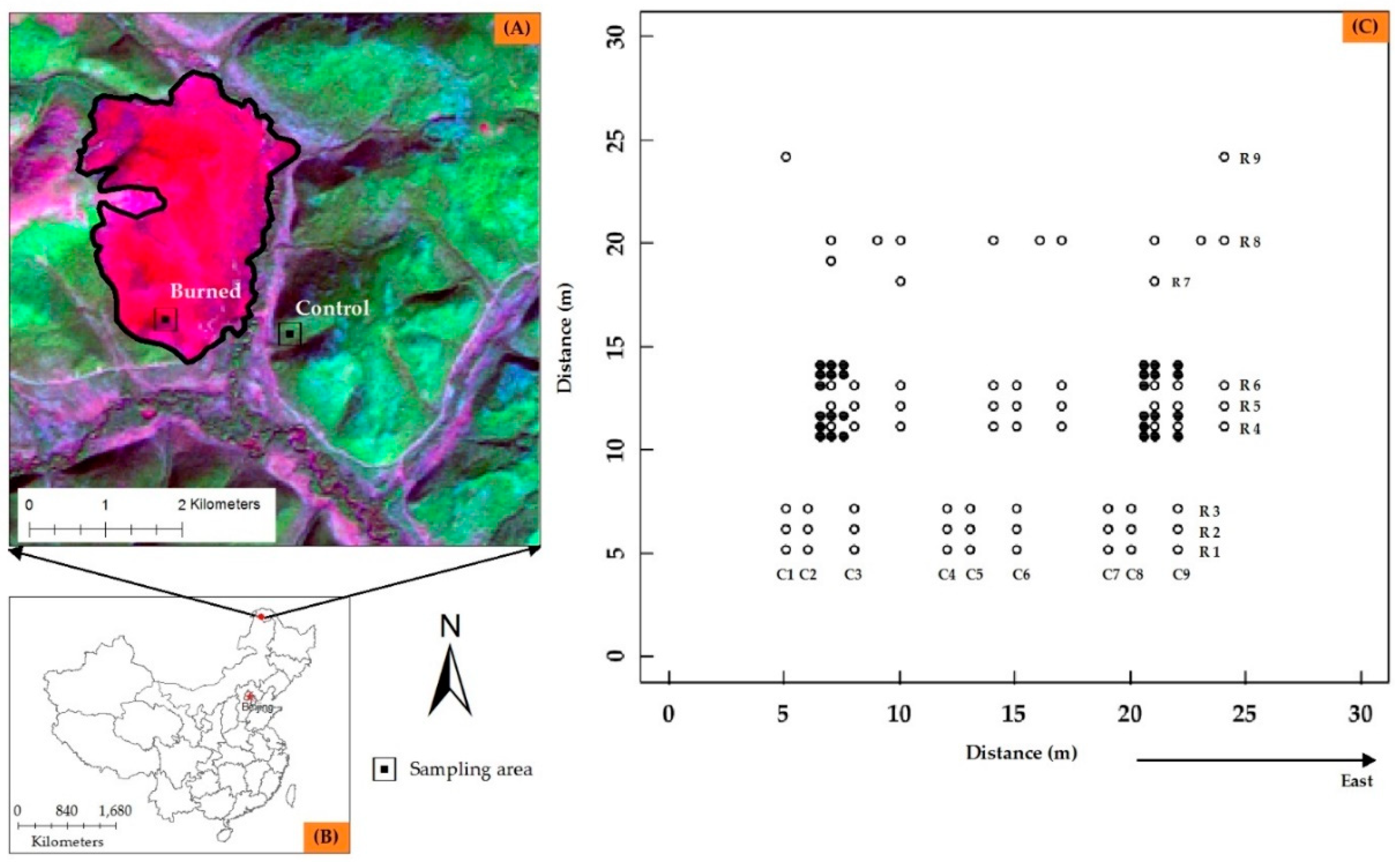
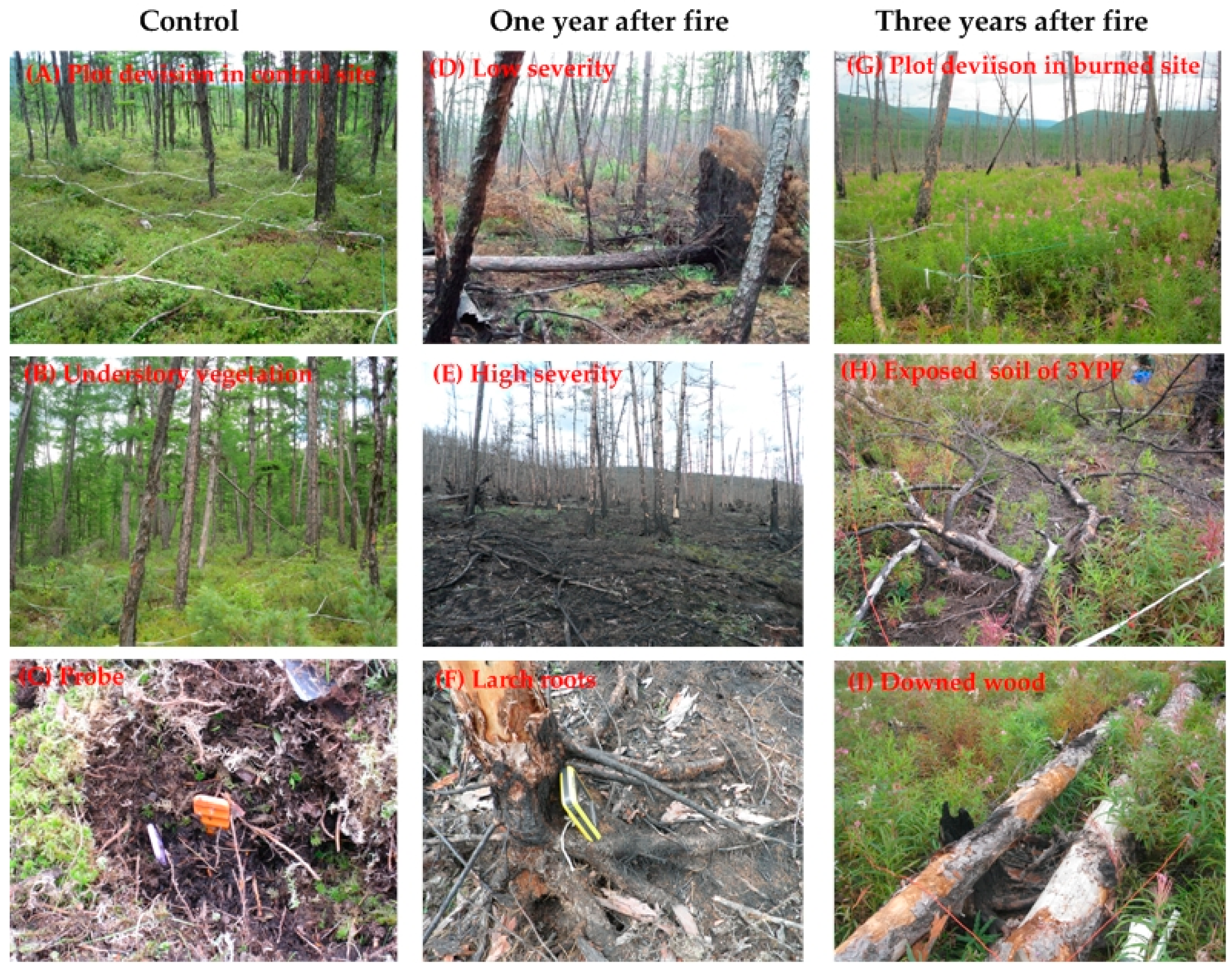
2.1. Study Area

We performed this study in a Larix gmelinii forest stand in Huzhong National Natural Reserve (51°17′42″ N, 122°42′14″ E to 51°56′31″ N, 123°18′05″ E) in the Great Xing’an Mountains of northeastern China (Figure 1). The elevation of the study area is between 600 and 1500 m, with gently sloping uplands. The valley bottom is frequently characterized by seasonally frozen ground or discontinuous permafrost [39]. The region has a terrestrial monsoon climate with long and severe winters, and warm and mild summers. The mean annual precipitation and temperature are ~500 mm and −4.7 °C, respectively. The soil is classified as brown conifer forest soils based on Chinese soil taxonomy [40]. The dominant vegetation is Dahurican larch (Larix gmelinii (Rupr.) Kuzen.), mixed with birch (Betula platyphylla Suk.) and Scotch pine (Pinus sylvestris L. var. mongolica Litv.). Under the pine tree species, the understory is sparse and generally dominated shrubs, including cowberry (Vaccinium vitis-idaea L.), wild rosemary (Ledum palustre L.), bog biberry (Vaccinium uliginosum L.) and Rhododendron dauricum L.
The historic fire regime was characterized by frequent, low-intensity surface fires mixed with infrequent stand-replacing fires, with an average fire return interval of 30 to 120 years in this boreal larch forest stands prior to the 1950s [39]. However, the historic fire regime has been greatly altered due to fire suppression and forest harvesting. The current fire regime of this area is characterized by infrequent and high-severity fires with a fire return interval of 300–500 years based on a landscape simulation model [41]. However, recent studies have found that the Great Xing’an Mountains are the most fire-prone area of China [42,43]. From 1967 to 2009, fire density greatly increased due to the accumulation of fuels and increases in human activity and climate warming [43]. On 26 June 2010, a wildfire burned approximately 670 ha within the Huzhong Natural Reserve. This large burned patch has high heterogeneity in fire severity due to variations in fuel loading, topography, and plant types (Figure 2), providing a rare opportunity to examine post-fire changes in the spatial heterogeneity of soil nitrogen availability and aboveground cover in this forest.

2.2. Field Sampling and Laboratory

We established two 30 m × 30 m plots in July 2013, with one at the burned site and the other at a nearby unburned site. These two plots were located on the mesic flat valley bottom and had similar pre-fire vegetation structure, topography and soil characteristics (Table A1; Figure 2). Thus, the unburned site was used as a control. At each site, the plot was oriented north. In the control plot, we established a grid (n = 68 sampling points, empty circle in Figure 1C) with a repeated sequence of sampling points. This grid included 9 parallel rows for plant investigation and soil sampling. In this grid, a minimum lag distance between sampling points was 1.0 m. The sampling scheme in the first six rows and the eighth row was similar to that of Turner et al. [7]. In these seven rows, each row included three 18-m cycles in which 3 of every 7 grid points were sampled at intervals of 1, 2 and 3 m. The seventh and ninth rows included two random points. The 4th to 6th rows were offset 2 m towards the east in the plot. In the burned plot, 28 additional points (solid circles in Figure 1C) were arranged for finer-scale sampling. The layout of 28 points was similar to that of Turner et al. [7], except the minimum lag distance between sampling points was 0.5 m rather than 2.0 m. The burned plot had 96 sampling points. This cyclic sampling protocol is efficient in the study of spatial patterns, as it can create comparable power at variable lag distances and maximize sampling efficiency [44] and has been used in some ecological studies [7,30].
At each sampling point, the soil sample was collected from 0–15 cm of the soil, and vegetation was measured. We measured the percentage of biotic cover of the functional groups (herb, shrub and regeneration tree seedling) and abiotic cover (litter and coarse woody debris) within a 30 m × 30 m square frame within a 0.25-m2 circular frame at each sampling point. Regeneration tree seedlings (RTS) referred to regeneration seedlings of birch, aspen and larch. Additionally, the depth of the organic horizon was measured at each sampling point. In each 0.25-m2 circular frame, the cover of each variable was summed to 100%.
We determined in situ N availability by inserting PRSTM probes (Plant Root SimulatorTM probes, Western Ag Innovations, Saskatoon, SK, Canada). One pair of PRSTM probes comprises anion and cation exchange membranes, which adsorb NO3 and NH4+. At each sampling point, one pair (1 cation and 1 anion) of probes was inserted vertically 15cm into the soil (Figure 2) and incubated in the field for four weeks (from 22 July to 19 August 2013). We packed the soil around the probes to ensure full contact between the soil and resin membrane. After completing a four-week incubation, all probes were removed from the soil, cleaned with deionized water, stored in Zipseal plastic bags, and shipped on ice to Western Ag, Inc., Saskatoon, SK, Canada for analysis. Available N, including NO3 and NH4+, was eluted with 1 M KCl. Values were expressed as μg N cm−2 per 10 cm−2. We used a 1:5 fresh soil to water ratio to measure soil pH.

2.3. Statistical Analysis

To examine the variations in soil N variables and local site characteristics (including pH, depth of organic matter layer and aboveground cover) within stands (Question 1), means, standard errors and coefficients of variation (CV, standard deviation/mean × 100) were calculated for soil N variables, soil resource variables and aboveground cover in each plot (Table 1). The CV is a relative measure of variability [45], and distributions with CV < 100% indicate low-variance, while those with CV > 100% indicate considerably high variance [46].
Semi-variogram analysis [47] was used to examine the spatial heterogeneity for all variables (Question 2). Three types of semi-variogram models were fitted to the data, with (1) the nugget model indicating random spatial structure or lack of spatial auto-correlation at the scale studied, and (2) the spherical and exponential models exhibiting asymptotic spatial structure in which semi-variance levels off after a certain lag distance [48]. These models were compared using a likelihood ratio test, and a p value < 0.05 was used to determine whether there was significant evidence for spatial dependence. For those locations that had significant spatial structure, we calculated three standard parameters (nugget, sill, and range) for each variogram. The nugget (C0) is the variance that is not spatially dependent. The sill (C0 + C) indicates where samples are no longer correlated, and the range represents the geographic scale of spatial dependence or the distance over which measurements are autocorrelated. To estimate the magnitude of spatial dependence, we calculated structure variance (C/(C0 + C)), the percentage of semi-variance related to spatial dependence. Structural variance greater than one indicates a strong spatial structure. In contrast, structure variance close to zero indicates no spatial structure in the range of scale studied.
To determine whether measures of soil N variables within stands were related to local site characteristics at the individual core level (Question 3), we computed Pearson correlation coefficients between soil N variables and local site characteristics by sampling point in the unburned and burned plots. All statistical analyses were performed with R 3.11 statistical software (R Development Core Team, Boston, MA, USA). We checked normality and equality of data variance before performing statistical analyses.

3. Results

3.1. Within-Plot Variability of Soil N Availability and Site Characteristics

The burned soil had significantly higher soil NO3 relative to the control (17.7 vs. 2.4 μg N 10 cm−2) (Table 1). In contrast, the mean soil NH4+ at the burned site was significantly lower than that at the control site (4.6 vs. 5.4 μg N 10 cm−2). At the control and burned sites, CVs for soil NO3 were above 100%, while CVs for soil NH4+ were below 50%. Within-plot variability (quantified by CV) was lower for soil NO3 and NH4+ at the burned site (Table 1) than at the control site.
Relative to the control, the depth of the organic horizon (DOH) decreased from 30.5 to 26.0 cm after fire (Table 1). In contrast, the soil pH increased from 4.7 to 5.1 after fire. The percent cover of herbs, litter and coarse woody debris (CWD) was significantly higher at the burned site than at the control site, where shrub cover was significantly lower (Table 1). There were no significant differences in the regeneration tree seedling cover between the burned and control sites. CVs for soil environmental variables (e.g., pH and DOH) were very low (<50%) at both the control and burned sites (Table 1). The variability in most aboveground cover variables at the control site was greater than those at the burned site except for shrub cover. At the control site, CVs for most aboveground cover variables were above 100%, while CVs for the shrub cover variable were below 50%.

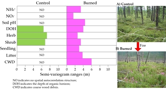
3.2. Spatial Structure Andheterogeneity of within-Plot Variability

The soil N variables did not exhibit a spatial structure at the control site (Table 2; Figure 3A,C). In contrast, wildfire did have effects on the spatial structure of the soil NH4+ and NO3. Structural variances for NO3 and NH4+ at the burned site were 90% and 100%, respectively, and showed obvious strong spatial structure at the burned site, suggesting that wildfire increased the spatial heterogeneity of soil N availability (Table 2; Figure 3B,D). The ranges of spatial autocorrelation of soil NO3 and NH4+ were 1.6 and 3.5 m, respectively.
At the control site, soil pH did not exhibit a spatial structure, while a moderate spatial structure was detected in DOH (Table 2). The structural variances for soil pH and DOH at the burned site were 91% and 82%, respectively, and exhibited strong spatial structures (Table 2). The range of spatial autocorrelation of soil pH was 4.3 m. Relative to the control site, the spatial autocorrelation range of DOH decreased from 6.5 to 4 m at the burned site (Table 2), suggesting that the degree of DOH spatial heterogeneity greatly increased. Structural variances for herb and shrub cover at the control site were 90% and 82%, respectively, suggesting a strong spatial structure, while RTS, litter and CWD cover variables did not exhibit strong spatial dependences. At the burned site, all understory cover variables had obvious spatial structures (Table 2). The spatial autocorrelation ranges of RTS, litter and CWD cover were 3.0, 3.8 and 6.0 m, respectively. After the fire, the spatial autocorrelation ranges of herb and shrub cover variables decreased from 7.3 to 2.7 m and from 6.9 to 3.5 m, respectively, relative to the control (Table 2), and showed higher heterogeneity after the fire.

3.3. Relationships between Soil N Availability and Local Site Characteristics

Wildfire affected the correlations between soil N variables and site characteristics (Table 3). At the control site, site characteristic variables were not correlated with soil NO3 (Table 3). Soil NH4+ was significantly negatively correlated with DOH and litter cover. At the burned site, soil NO3 was significantly positively correlated with residual DOH and soil pH, but was not correlated with other site characteristic variables (Table 3). Soil NH4+ was significantly negatively correlated with residual DOH and herb cover, positively correlated with RTS cover, and marginally negatively correlated with soil pH. Additionally, the numbers of correlations between soil N variables and soil properties increased after fire relative to the control (Table 3).

4. Discussion

4.1. Within-Plot Variability of Soil N and Site Characteristics

Soil NO3 increased nearly six times at the 3-year-post-burn site compared with the control site, but soil NH4+ significantly decreased. This great increase in soil NO3 after a fire has been reported elsewhere [18,49]. Together, these studies suggested that a higher soil nitrification rate after fire may be related to the pulse of NH4+ immediately after fire, higher soil temperature, and greater pH [50], which are generally invoked as mechanisms that induce nitrification following fire [20]. In our study area, a previous study found that soil NH4+ significantly increased one year after fire [51]. The increased soil NH4+ immediately after fire can be transformed to nitrate by autotrophic nitrification in the first few years after fire and thus lead to great increase in nitrate. In contrast, regeneration plants, particularly herbaceous plants likely decreased soil NH4+ by nutrient uptake and produced litter to immobilize NH4+. Such processes may also be primarily responsible for the decrease in soil NH4+ pool three years after fire.
In the burned site, herb cover increased relative to the control. This increase may be due to the rapid colonization and establishment of fast-growing vascular plants. Among the colonized species, fireweed (Chamaenerion angustifolium (L.) Scop.) as a pioneer species can dominate the valley bottom in the post-fire initial succession stage and thus create a higher herb cover. In addition, litter and CWD cover were higher in the burned site. Fire-caused death of trees can supply large bark, downed woods, dead roots and charred litter (e.g., branches, twigs, tree trunks). Fresh litter from regeneration vegetation may also contribute to the increases in litter cover after fire. However, we observed lower shrub cover in the burned site relative to the control, a result consistent with those of Liu et al. [37] for the same fire. This decrease may be caused by slower regeneration rate since wildfire can partly or completely damage the bud bank [52]. In this study, we observed that RTS cover in the burned site was slightly higher than in the control, but the difference was not significant. The low regeneration density of trees in the control site may be related to older tree age, deeper soil organic horizon, and less light [27]. In mature larch forests, a thick layer of mosses, lichens and leaf litter can decrease the survival rate of larch or birch seedlings since these materials can hinder seedling roots from reaching the stable soil water and nutrients provided by underlying mineral soils [27,32]. Additionally, mature forests with canopy closure may allow little light to reach the understory environments. Such environments may be unfavorable for the regeneration of birch and larch since these two species are shade intolerant. In contrast, the low cover of RTS 3 years after fire may be due to a lack of seeds. In our study area, we observed that wildfire removed an average of 4.5 cm of the organic horizon and thus likely killed the seeds stored in this layer. The wildfire killed all birch and larch trees, hence resulting in scarce on-site seed production. Our plot location was far (>300 m) from the nearby unburned area. As a result, there may be limited numbers of birch or larch seeds brought to the site through seed dispersal.
Although wildfire did not exert significant effects on regeneration tree seedling cover, it greatly reduced RTS relative variability. The decrease in variability may be related to seed availability and characteristics of microsites. Combined with the low value of RTS cover, the decrease in variability likely reflects the very low availability of birch or larch seeds in the burned area. Relative variability in shrub cover after fire became greater than the control site, and its cover values changed from 0.0–48% relative to the control of 2.0–100% (Table 1), indicating that shrub may have slower regeneration at the 3-year-post-fire site. The higher variability may be related to higher heterogeneity in soil burn severity. Severe burning can decrease the organic horizon depth and bud bank in the soil [52], and thus produce less shrub regeneration. This finding was consistent with those of other researchers who reported that post-fire variability in shrub cover decreased with time after fire [7,11]. These studies suggested that the post-fire pattern of shrub cover was similar to the early succession stage. In the initial stage, shrub cover is very sparse and dominated by herbaceous vegetation [6]. As time after fire increases, the spatial structure of shrub cover may be homogenized in the late succession stage because the recruited shrubs increased in size, flowered, and produced seed and thus filled in the unvegetated space [53,54]. This explanation may be responsible for the decrease in variability in shrub cover in our study.
We observed lower variability in herbaceous cover in the burned site than in the control, which is consistent with other studies (e.g., Hart et al. [54] and Roberts [55]). Generally, wildfires decrease forest floor thickness, release nutrients from organic matter and increase soil pH [56,57]. Additionally, wildfires remove the forest canopy and thus, increase light transmission. In total, wildfires produce fertile and light understory environments that can be quickly occupied by some shade-intolerant and nutrient-demanding species [38,54], such as fireweed, celandines (Chelidonium majus L.), raspberry (Rubus corchorifolius L. f.) and bushgrass (Calamagrostis epigejos (L.)Roth). These species can rapidly grow in the soil with abundant resources and dominate the burned area. Additionally, the burned site in our study had lower variability in available soil N in the burned site which may be beneficial for vascular plants to grow and propagate. In this field work, we also observed much herbaceous vegetation, such as fireweed, which occupied the recently burned space and homogenized the aboveground environments at the valley bottom. At the control site with mature trees, herbaceous species disappeared and were gradually replaced by shade-tolerant species as the canopy close and nutrients decrease [54]. Thus, mature forests may have higher variability in herbaceous plants.
Lower variability in soil NH4+ was observed after the fire. This result is consistent with those of Rodriguez et al. [25] for a pine forest, and Hirobe et al. [36] for a dry tropical forest. These studies suggested that such low variability may be caused by ash deposition from organic matter evenly distributed on the soil surface. As an alternative possibility, lower variability in soil resource variables (e.g., soil pH and DOH) was detected in this study, which may contribute to low variability in soil nitrogen mineralization. In contrast, variability in soil NO3 after the fire was greater. This result is consistent with those of previous studies [7]. Greater CV in soil NO3 likely reflects the greater sensitivity of nitrifiers to soil heating and the greater soil environmental constraints (e.g., soil pH and temperature) on nitrification [50]. Previous studies have suggested that fire changed the soil microbial community, substrate quantity and quality, and produced large amounts of charcoal [18,58], thus affecting nitrate contents [24].

4.2. Changes in Spatial Heterogeneity in Soil N and Site Characteristics

Strong spatial heterogeneity was detected in soil pH and DOH at the burned site relative to the control site. For some aboveground cover variables, although there was no spatial pattern at the control site, there were evident spatial patterns for all aboveground cover variables after the fire. These results suggested that wildfire could produce spatial heterogeneity for soil resource and aboveground cover variables. A previous study also observed clear spatial heterogeneity in aboveground cover and soil resources following fire in an Alaskan boreal forest [11]. We found that fire decreased the scale of autocorrelation for all site characteristic variables, which may provide more heterogeneous fine patches with variable soil resources and site conditions for colonization and establishment of species in the post-fire early succession stage. Therefore, such high heterogeneity may create abundant species diversity for this ecosystem during the early stage of post-fire succession, and further influence the long-term succession trajectory of this forest ecosystem since species composition in the initial succession stage would play an important role in controlling community composition in the middle and late stages of succession [59].
Although a spatial pattern in soil N availability was absent at the control site at the scales we sampled, there was an obvious spatial pattern after fire. Within-stand spatial patterns in soil NH4+ and NO3 were apparent at finer scales (<4 m). This result suggested that fire could increase soil N spatial heterogeneity, which was consistent with the results of Lavoie and Mack [11] for an Alaskan boreal forest and Rodriguez et al. [25] for a Spanish pine forest. These two studies attributed the increases in heterogeneity to the highly heterogeneous microsites with variable ash layers, organic horizons, and regeneration vegetation cover. In this study, the increases in heterogeneity of soil N variables may be related to the distributions of ash, downed trees, charred stems and branches and regeneration vegetation at the microsites. Following fire, coarse wood debris and charred stems and branches on the ground can intercept ashes with higher inorganic N in some microsites which may provide advantages to new recruits. Regeneration plants, especially herbs clustering at the burned site, can decrease soil N availability by uptake of nutrients. Charcoal in the burned site is heterogeneously distributed on the ground, and soil can stimulate nitrification and reduce NH4+ erosion through adsorption [60]. Alternatively, wildfire created high heterogeneity in moss and lichen cover, which may affect heterogeneity in soil N availability by altering soil water and temperature conditions. Our results were inconsistent with those of Das Gupt and Mackenzie [26], who showed a greater spatial range (>23 m) of soil available N after fire. This difference may be related to the types of ecosystems and fires and the post-fire time. These authors performed their study in a 1-year-post-burned site in a boreal aspen forest with a severe stand-replacing fire. Additionally, a thinner residual soil organic layer (i.e., average of 5.2 vs. 26.0 cm in this study) could explain the differences between the two studies.
The spatial coupling of soils and vegetation is closer because of plant uptake for soil nutrients and vegetation returning litter to the soil [3,53,61], but this coupling may be changed by some disturbances [25,62]. Wildfire as an important natural disturbance can fully or partially remove the aboveground plants and forest floor; thus, the coupling of soils and vegetation could weaken or disappear. In this study, we did not observe consistent patterns in the estimated autocorrelation ranges of aboveground cover and soil NO3 after fire; this lack of consistency indicates that the spatial patterns of these variables were not coupled at the examined scales between 1 and 28 m 3 years after fire. This finding is consistent with those of other studies (e.g., Turner et al. [7]; Guo et al. [62]). It is well known that plants and soil microbial communities prefer NH4+ to NO3 as a source of nitrogen [63]; thus, the effects of understory vegetation on the spatial patterns of soil nitrate may be minimal. However, the within-stand spatial pattern in soil NH4+ was coupled with the patch sizes of aboveground cover (e.g., herbs, shrubs and seedlings) at the sampled scales, which verified that there was likely a tight spatial coupling of soil resources and vegetation. The spatial patch size of N as a limiting resource may determine the probability of finding a favorable site for growth of new individual plants, and thus have important consequences for forest regeneration [4]. For example, on a nutrient-rich patch following fire, seeds in the soil or live plants may be more prone to survive relative to those on a nutrient-poor patch in forest restoration. Some research has also demonstrated spatial heterogeneity in soil available N related to the spatial arrangement of aboveground organisms in a dry dipterocarp forest [36]. Other research has observed variations in soil available N at fine scales related to the spatial structure of soil microbes [64,65].

4.3. Relationship between Soil N and Site Characteristics

In this study, wildfire altered the relationship between site characteristics and N availability at the individual sampling point level. The number of significant correlations between soil properties and N variables increased relative to the control. For example, we observed stronger correlations between soil N variables (e.g., NO3, NH4+) and DOH in the burned area than at the control site. These high correlations in the burned area were probably related to fire-induced changes in soil environments (e.g., high soil temperature, low soil water content and larger charcoal), which could stimulate soil N mineralization [20]. Alternatively, the correlations could also suggest that the residual organic horizon had more influence on mineralization in the early post-fire succession and that the effects of the organic horizon became weaker in the later undisturbed succession. For soil NH4+, the lack of changes in relationships with DOH between the burned and control sites could indicate that the quantity and quality of post-fire C substrate still limited N mineralization due to the inherent inhibition of larch needles in the organic horizon in this boreal forest [27]. At the burned site, we observed a significant relationship between soil NO3 and pH after fire, indicating local coupling. However, soil NO3 was not correlated with RTS, shrub, litter and CWD cover, indicating de-coupling or processes that cancel each other, but our data cannot distinguish between these alternatives.
At the control site, soil NH4+ was not related to aboveground cover variables except for litter cover at the individual sampling point level, indicating no local coupling. However, at the burned site, we observed significant relationships between soil NH4+ and RTS and herb cover variables at the sampling point level, indicating local coupling. The negative correlation between soil NH4+ and herb cover indicated that the increased soil NH4+ after fire could stimulate growth of regeneration vascular plants [38] as shade-intolerant and nutrient-demanding pioneer species. In the field work, we observed that great amounts of herbaceous plants (e.g., willow) dominated the burned area, which may reduce soil NH4+ through plant uptake and storing this N in plant tissues [66]. Relative to the vascular plants, the number and size of RTS such as aspen or birch seedlings were small. In such environments, vascular plants would be more competitive for soil resources than regeneration birch and aspen trees, which could lead to some negative effects on their growth [38,67]. In this study, the positive correlation between soil NH4+ and regeneration tree seedlings suggested that the reduced NH4+ may affect growth of regeneration tree seedlings in the post-fire early succession stage in the valley larch forest of Huzhong National Reserve. Consequently, in the burned area, soil N availability may influence new individual establishment and growth and further affect the structure and dynamics of plant populations and communities in these areas.

5. Conclusions

This study suggests higher fine-scale spatial heterogeneity in soil N availability and site characteristics after fire relative to the control. Although spatial patterns for soil N and most site characteristic variables at the control site were lacking, there were obvious spatial patterns in soil N and all site characteristic variables after fire. The patch of soil ammonium was coupled with the spatial scale of understory vegetation. Additionally, significant correlations at the individual sampling point level indicated that soil resources (e.g., soil pH and DOH) influenced soil N and that available soil N affected the growth of some regeneration understory vegetation in the post-fire early succession stage. These results suggest that the post-fire initial patterns of soil resources and regeneration vegetation may be responsible for fine-scale heterogeneity in available soil N. These findings also suggest that the spatial distribution of limiting resources (i.e., NH4+) could determine the performance of new individual tree recruits in the post-fire early succession stage [5,66], and therefore may have effects on the spatial distribution of the plant community. Further long-term studies at multiple scales are needed to elucidate the spatial dynamics of vegetation–soil relationships.

Author Contributions

J.K. and J.Y. conceived and designed the study. J.K. and J.Y. wrote and revised the manuscript. L.Q. and B.L. contributed to analyzing data and field work.

Funding

This research was funded by the National Key Research and Development Program of China (2017YFA0604403), the National Natural Science Foundation of China (41501200, 31800376, 31800395), Doctoral programs from Liaoning Province (201601151) and Shenyang Normal University (bs201507).

Acknowledgments

The authors are grateful to the Huzhong Natural Reserve for field investigations. The authors thank Zhihua Liu, Wenhua Cai and Jiaxing Zu for their hard field work and thank Hengyu Zhang and Shuang Jing for soil sampling analysis.

Conflicts of Interest

The authors declare no conflict of interest.

Appendix A

Table A1. Basic characteristics of forest vegetation and forest fuel loads in the control area. Values in the table are the range of each variable.
Control3-Year-Post-Fire
Forest Floor
Organic horizon depth (cm)12–5512–40
Litter load (kg m−2)3.3 × 10⁴–5.4 × 10⁴-
CWD load (m3 ha−2)5.92–43.53-
Understory vegetation
Herbaceous height (cm)10–405–100
Shrub height (cm) 3–30
Rhododendron dauricum L.50–130-
Vaccinium uliginosum L.23–352–6
Ledum palustre L.9–402–8
Vacciniumvitis-idaea L.5–102–5
Pinuspumila60–150-
Larch trees
Height (m)15–30-
DBH (cm)20–28-
SM indicates soil moisture; DBH indicates diameter of breast height; CWD: coarse wood debris.

References

  1. Cohn, J.S.; Di Stefano, J.; Christie, F.; Cheers, G.; York, A. How do heterogeneity in vegetation types and post-fire age-classes contribute to plant diversity at the landscape scale? For. Ecol. Manag. 2015, 346, 22–30. [Google Scholar] [CrossRef]
  2. John, R.; Dalling, J.W.; Harms, K.E.; Yavitt, J.B.; Stallard, R.F.; Mirabello, M.; Hubbell, S.P.; Valencia, R.; Navarrete, H.; Vallejo, M.; et al. Soil nutrients influence spatial distributions of tropical tree species. Proc. Natl. Acad. Sci. USA 2007, 104, 864–869. [Google Scholar] [CrossRef] [PubMed]
  3. Robertson, G.P.; Hutson, M.A.; Evans, F.C.; Tiedje, J.M. Spatial variability in a successional plant community: Patterns of nitrogen availability. Ecology 1988, 69, 1517–1524. [Google Scholar] [CrossRef]
  4. Gallardo, A.; Paramá, R.; Covelo, F. Differences between soil ammonium and nitrate spatial pattern in six plant communities. Simulated effect on plant populations. Plant Soil 2006, 279, 333–346. [Google Scholar] [CrossRef]
  5. Hutchings, M.J.; John, E.A.; Wijesinghea, D.K. Toward understanding the consequences of soil heterogeneity for plant populations and communities. Ecology 2003, 84, 2322–2334. [Google Scholar] [CrossRef]
  6. De Long, J.R.; Dorrepaal, E.; Kardol, P.; Nilsson, M.-C.; Teuber, L.M.; Wardle, D.A. Understory plant functional groups and litter species identity are stronger drivers of litter decomposition than warming along a boreal forest post-fire successional gradient. Soil Biol. Biochem. 2016, 98, 159–170. [Google Scholar] [CrossRef]
  7. Turner, M.G.; Romme, W.H.; Smithwick, E.A.H.; Tinker, D.B.; Zhu, J. Variation in aboveground cover influences soil nitrogen availability at fine spatial scales following severe fire in subalpine conifer forests. Ecosystems 2011, 14, 1081–1095. [Google Scholar] [CrossRef]
  8. Saar, S.; Semchenko, M.; Barel, J.M.; de Deyn, G.B. Spatial heterogeneity in root litter and soil legacies differentially affect legume root traits. Plant Soil 2018, 428, 253–264. [Google Scholar] [CrossRef]
  9. Delgado-Baquerizo, M.; Maestre, F.T.; Gallardo, A.; Bowker, M.A.; Wallenstein, M.D.; Quero, J.L.; Ochoa, V.; Gozalo, B.; Garcia-Gomez, M.; Soliveres, S.; et al. Decoupling of soil nutrient cycles as a function of aridity in global drylands. Nature 2013, 502, 672–676. [Google Scholar] [CrossRef]
  10. Ford, S.; Kleinman, J.; Hart, J. Spatial patterns of canopy disturbance, structure, and species composition in a multi-cohort hardwood stand. Forests 2017, 8, 93. [Google Scholar] [CrossRef]
  11. Lavoie, M.; Mack, M.C. Spatial heterogeneity of understory vegetation and soil in an Alaskan upland boreal forest fire chronosequence. Biogeochemistry 2012, 107, 227–239. [Google Scholar] [CrossRef]
  12. Fang, L.; Yang, J.; White, M.; Liu, Z. Predicting potential fire severity using vegetation, topography and surface moisture availability in a eurasian boreal forest landscape. Forests 2018, 9, 130. [Google Scholar] [CrossRef]
  13. Kasischke, E.S.; Turetsky, M.R.; Ottmar, R.D.; French, N.H.F.; Hoy, E.E.; Kane, E.S. Evaluation of the composite burn index for assessing fire severity in Alaskan black spruce forests. Int. J. Wildland Fire 2008, 17, 515–526. [Google Scholar] [CrossRef]
  14. Flannigan, M.; Stocks, B.; Turetsky, M.; Wotton, M. Impacts of climate change on fire activity and fire management in the circumboreal forest. Glob. Chang. Biol. 2009, 15, 549–560. [Google Scholar] [CrossRef]
  15. Tokuchi, N.; Hirobe, M.; Kondo, K.; Arai, H.; Hobara, S.; Fukushima, K.; Matsuura, Y. Soil Nitrogen Dynamics in Larch Ecosystem. In Permafrost Ecosystems: Siberian Larch Forests; Springer: New York, NY, USA, 2010; pp. 229–244. [Google Scholar]
  16. DeLuca, T.; Sala, A. Frequent fire alters nitrogen transformations in ponderosa pine stands of the inland northwest. Ecology 2006, 87, 2511–2522. [Google Scholar] [CrossRef]
  17. Harden, J.W.; Mack, M.; Veldhuis, H.; Gower, S.T. Fire dynamics and implications for nitrogen cycling in boreal forests. J. Geophys. Res. 2002, 108, 8223–8230. [Google Scholar] [CrossRef]
  18. Certini, G. Effects of fire on properties of forest soils: A review. Oecologia 2005, 143, 1–10. [Google Scholar] [CrossRef] [PubMed]
  19. Neary, D.G.; Ryan, K.C.; de Bano, L.F. Wildland Fire in Ecosystems: Effects of Fire on Soil and Water; Gen. Tech. Rep. RMRS-GTR-42-vol.4; Department of Agriculture, Forest Service, Rocky Mountain Research Station: Ogden, UT, USA, 2005; p. 250. [Google Scholar]
  20. Smithwick, E.A.H.; Turner, M.G.; Mack, M.C.; Chapin, F.S. Postfire soil N cycling in northern conifer forests affected by severe, stand-replacing wildfires. Ecosystems 2005, 8, 163–181. [Google Scholar] [CrossRef]
  21. Kong, J.-J.; Yang, J.; Chu, H.; Xiang, X. Effects of wildfire and topography on soil nitrogen availability in a boreal larch forest of northeastern China. Int. J. Wildland Fire 2015, 24, 433–442. [Google Scholar] [CrossRef]
  22. Wan, S.; Hui, D.; Luo, Y. Fire effects on nitrogen pools and dynamics in terrestrial ecosystems: A meta-analysis. Ecol. Appl. 2001, 11, 1349–1365. [Google Scholar] [CrossRef]
  23. Adkins, J.; Sanderman, J.; Miesel, J. Soil carbon pools and fluxes vary across a burn severity gradient three years after wildfire in Sierra Nevada mixed-conifer forest. Geoderma 2019, 333, 10–22. [Google Scholar] [CrossRef]
  24. Koyama, A.; Kavanagh, K.; Stephan, K. Wildfire effects on soil gross nitrogen transformation rates in coniferous forests of Central Idaho, USA. Ecosystems 2010, 13, 1112–1126. [Google Scholar] [CrossRef]
  25. Rodríguez, A.; Durán, J.; Fernández-Palacios, J.M.; Gallardo, A. Wildfire changes the spatial pattern of soil nutrient availability in Pinus canariensis forests. Ann. For. Sci. 2009, 66, 210. [Google Scholar] [CrossRef]
  26. Das Gupta, S.; MacKenzie, M.D. Recovery from fire affects spatial variability of nutrient availability in boreal aspen ecosystems. bioRxiv 2018. [Google Scholar] [CrossRef]
  27. Osawa, A.; Zyryanova, O.A.; Matsuura, Y.; Kajimoto, T.; Wein, R.W. Permafrost Ecosystems: Siberian Larch Forests; Springer: New York, NY, USA, 2010. [Google Scholar]
  28. Jackson, R.B.; Caldwell, M.M. Geostatistical patterns of soil heterogeneity around individual perennial plants. J. Ecol. 1993, 81, 683–692. [Google Scholar] [CrossRef]
  29. Schlesinger, W.H.; Raikes, J.A.; Hartley, A.E.; Cross, A.F. On the spatial pattern of soil nutrients in desert ecosystems. Ecology 1996, 77, 364–374. [Google Scholar] [CrossRef]
  30. Smithwick, E.A.H.; Mack, M.C.; Turner, M.G.; Chapin, F.S.; Zhu, J.; Balser, T.C. Spatial heterogeneity and soil nitrogen dynamics in a burned black spruce forest stand: Distinct controls at different scales. Biogeochemistry 2005, 76, 517–537. [Google Scholar] [CrossRef]
  31. Boby, L.A.; Schuur, E.A.G.; Mack, M.C.; Verbyla, D.; Johnstone, J.F. Quantifying fire severity, carbon, and nitrogen emissions in Alaska’s boreal forest. Ecol. Appl. 2010, 20, 1633–1647. [Google Scholar] [CrossRef]
  32. Alexander, H.D.; Natali, S.M.; Loranty, M.M.; Ludwig, S.M.; Spektor, V.V.; Davydov, S.; Zimov, N.; Trujillo, I.; Mack, M.C. Impacts of increased soil burn severity on larch forest regeneration on permafrost soils of far northeastern Siberia. For. Ecol. Manag. 2018, 417, 144–153. [Google Scholar] [CrossRef]
  33. Cai, W.; Yang, J.; Liu, Z.; Hu, Y.; Weisberg, P.J. Post-fire tree recruitment of a boreal larch forest in Northeast China. For. Ecol. Manag. 2013, 307, 20–29. [Google Scholar] [CrossRef]
  34. Brown, C.D.; Liu, J.; Yan, G.; Johnstone, J.F. Disentangling legacy effects from environmental filters of postfire assembly of boreal tree assemblages. Ecology 2015, 96, 3023–3032. [Google Scholar] [CrossRef] [PubMed]
  35. Ziegler, J.P.; Hoffman, C.; Battaglia, M.; Mell, W. Spatially explicit measurements of forest structure and fire behavior following restoration treatments in dry forests. For. Ecol. Manag. 2017, 386, 1–12. [Google Scholar] [CrossRef]
  36. Hirobe, M.; Tokuchi, N.; Wachrinrat, C.; Takeda, H. Fire history influences on the spatial heterogeneity of soil nitrogen transformations in three adjacent stands in a dry tropical forest in Thailand. Plant Soil 2003, 249, 309–318. [Google Scholar] [CrossRef]
  37. Liu, B.; Yang, J.; Johnstone, J.F. Understory vascular plant community assembly in relation to time-since-fire and environmental variables in a Chinese boreal forest. J. Mt. Sci. 2017, 14, 1317–1328. [Google Scholar] [CrossRef]
  38. Liu, Z.; Yang, J. Quantifying ecological drivers of ecosystem productivity of the early-successional borealLarix gmeliniiforest. Ecosphere 2014, 5, 1–16. [Google Scholar] [CrossRef]
  39. Xu, H.C. Forests in Daxing’anling Mountains China; Science Press: Beijing, China, 1998. [Google Scholar]
  40. Gong, Z.T. Chinese Soil Taxonomy; Science Press: Beijing, China, 2003. [Google Scholar]
  41. Chang, Y.; He, H.S.; Hu, Y.; Bu, R.; Li, X. Historic and current fire regimes in the Great Xing’an Mountains, northeastern China: Implications for long-term forest management. For. Ecol. Manag. 2008, 254, 445–453. [Google Scholar] [CrossRef]
  42. Hu, T.; Zhou, G. Drivers of lightning- and human-caused fire regimes in the Great Xing’an Mountains. For. Ecol. Manag. 2014, 329, 49–58. [Google Scholar] [CrossRef]
  43. Liu, Z.H.; Yang, J.; Chang, Y.; Weisberg, P.J.; He, H.S. Spatial patterns and drivers of fire occurrence and its future trend under climate change in a boreal forest of Northeast China. Glob. Chang. Biol. 2012, 18, 2041–2056. [Google Scholar] [CrossRef]
  44. Clayton, M.K.; Hudelson, B.D. Confidence intervals for autocorrelations based on cyclic samples. J. Am. Stat. Assoc. 1995, 90, 753–757. [Google Scholar] [CrossRef]
  45. Fraterrigo, J.M.; Rusak, J.A. Disturbance-driven changes in the variability of ecological patterns and processes. Ecol. Lett. 2008, 11, 756–770. [Google Scholar] [CrossRef]
  46. Available online: https://en.wikipedia.org/wiki/Coefficient_of_variation (accessed on 25 January 2019).
  47. Cressie, N.A.C. Statistics for Spatial Data, Revised Edition; Wiley: New York, NY, USA, 1993. [Google Scholar]
  48. Legendre, P.; Fortin, M.J. Spatial pattern and ecological analysis. Vegetation 1989, 80, 107–138. [Google Scholar] [CrossRef]
  49. Turner, M.G.; Smithwick, E.A.; Metzger, K.L.; Tinker, D.B.; Romme, W.H. Inorganic nitrogen availability after severe stand-replacing fire in the Greater Yellowstone ecosystem. Proc. Natl. Acad. Sci. USA 2007, 104, 4782–4789. [Google Scholar] [CrossRef] [PubMed]
  50. Ste-Marie, C.; Paré, D. Soil, pH and N availability effects on net nitrification in the forest floors of a range of boreal forest stands. Soil Biol. Biochem. 1999, 31, 1579–1589. [Google Scholar] [CrossRef]
  51. Kong, J.J.; Yang, J.; Cai, W. Topography controls post-fire changes in soil properties in a Chinese boreal forest. Sci. Total Environ. 2019, 651, 2662–2670. [Google Scholar] [CrossRef]
  52. Hautala, H.; Tolvanen, A.; Nuortila, C. Regeneration strategies of dominant boreal forest dwarf shrubs in response to selective removal of understorey layers. J. Veg. Sci. 2001, 12, 503–510. [Google Scholar] [CrossRef]
  53. Baret, M.; Pepin, S.; Ward, C.; Pothier, D. Long-term changes in belowground and aboveground resource allocation of boreal forest stands. For. Ecol. Manag. 2015, 350, 62–69. [Google Scholar] [CrossRef]
  54. Hart, S.A.; Chen, H.Y.H. Understory vegetation dynamics of North American boreal forests. Crit. Rev. Plant Sci. 2006, 25, 381–397. [Google Scholar] [CrossRef]
  55. Roberts, M.R. Response of the herbaceous layer to natural disturbance in North American forests. Can. J. Bot. 2004, 82, 1273–1283. [Google Scholar] [CrossRef]
  56. Kong, J.J.; Yang, J.; Bai, E. Long-term effects of wildfire on available soil nutrient composition and stoichiometry in a Chinese boreal forest. Sci. Total Environ. 2018, 642, 1353–1361. [Google Scholar] [CrossRef] [PubMed]
  57. Simard, D.; Fyles, J.; Paré, D.; Nguyen, T. Impacts of clearcut harvesting and wildfire on soil nutrient status in the Quebec boreal forest. Can. J. Soil Sci. 2001, 81, 229–237. [Google Scholar] [CrossRef]
  58. DeLuca, T.H.; MacKenzie, M.D.; Gundale, M.J.; Holben, W.E. Wildfire-produced charcoal directly influences nitrogen cycling in ponderosa pine forests. Soil Sci. Soc. Am. J. 2006, 70, 448–453. [Google Scholar] [CrossRef]
  59. Johnstone, J.F.; Hollingsworth, T.N.; Chapin, F.S. A Key for Predicting Postfire Succession Trajectories in Black Spruce Stands of Interior Alaska; Pacific Northwest Research Station PNW GTR-767; US Department of Agriculture, Forest Service: Portland, OR, USA, 2008.
  60. DeLuca, T.H.; Aplet, G.H. Charcoal and carbon storage in forest soils of the Rocky Mountain West. Front. Ecol. Environ. 2008, 6, 18–24. [Google Scholar] [CrossRef]
  61. García-Palacios, P.; Maestre, F.T.; Bardgett, R.D.; de Kroon, H. Plant responses to soil heterogeneity and global environmental change. J. Ecol. 2012, 100, 1303–1314. [Google Scholar] [CrossRef]
  62. Guo, D.; Mou, P.; Jones, R.H.; Mitchell, R.J. Spatio-temporal patterns of soil available nutrients following experimental disturbance in a pine forest. Oecologia 2004, 138, 613–621. [Google Scholar] [CrossRef] [PubMed]
  63. Stark, J.M.; Hart, S.C. High rates of nitrification and nitrate turnover in undisturbed coniferous forests. Nature 1997, 385, 61–64. [Google Scholar] [CrossRef]
  64. Schimel, J.P.; Bennett, J. Nitrogen mineralization: Challenges of a changing paradigm. Ecology 2004, 85, 591–602. [Google Scholar] [CrossRef]
  65. Smithwick, E.A.H.; Turner, M.G.; Metzger, K.L.; Balser, T.C. Variation in NH 4 + mineralization and microbial communities with stand age in lodgepole pine (Pinus contorta) forests, Yellowstone National Park (USA). Soil Biol. Biochem. 2005, 37, 1546–1559. [Google Scholar] [CrossRef]
  66. Romme, W.H.; Tinker, D.B.; Stakes, G.K.; Turner, M.G. Does inorganic nitrogen limit plant growth 3–5 years after fire in a Wyoming, USA, lodgepole pine forest? For. Ecol. Manag. 2009, 257, 829–835. [Google Scholar] [CrossRef]
  67. Tsuyuzaki, S.; Narita, K.; Sawada, Y.; Kushida, K. The establishment patterns of tree seedlings are determined immediately after wildfire in a black spruce (Picea mariana) forest. Plant Ecol. 2014, 215, 327–337. [Google Scholar] [CrossRef]
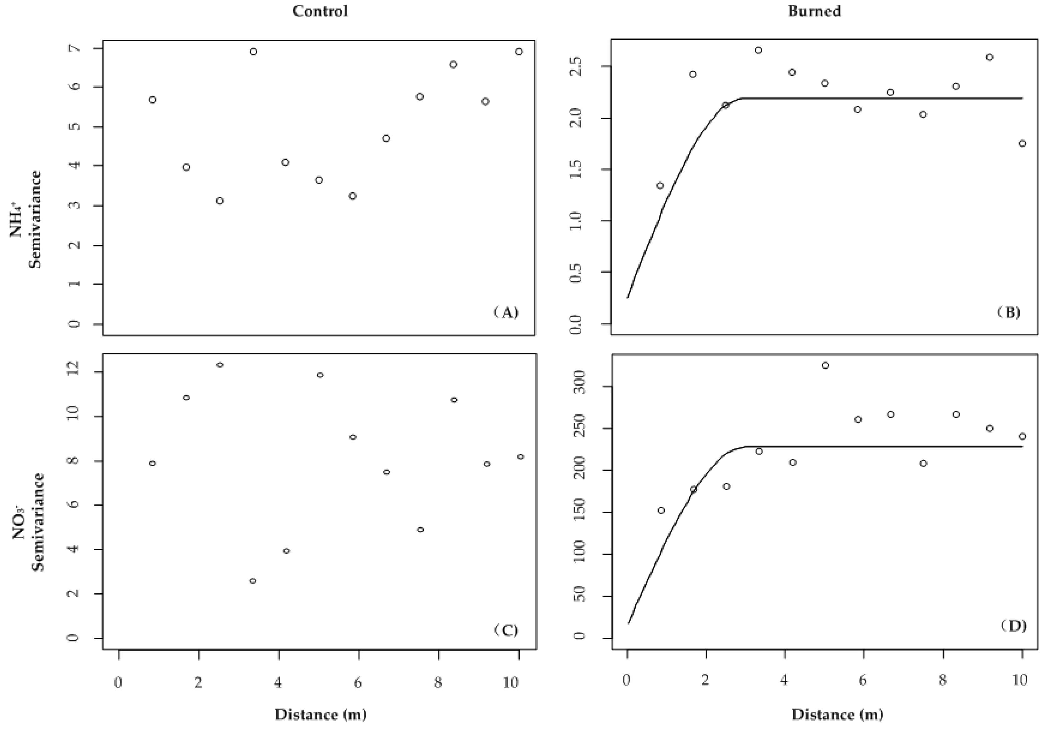
Figure 1. Location of study area (A) representing the sampling area, wildfire severity and the location of 3-year-post-fire site burning in 2010 (dark polygon) in the Huzhong Natural Reserve in the Great Xing’an Mountains of northeastern China (B). (C) represents the sampling design diagram for this study. The control site had 68 sampling points (i.e., empty circles) and the burned site had 96 points, including 68 empty and solid circles. The minimum and maximum distances between sampling points were 0.5 and 28 m, respectively. Cnumber and Rnumbering represent the number of each column and row in this sampling grid. 2.2. Field sampling and laboratory.
Forests 10 00095 g001
Figure 2. Photo collage showing the conditions of sampling plots at each of the control (A,B), 1-year-post-fire (DF), and 3-year-post-fire sites (GI). The usage of Plant Root SimulatorTM probes (Western Ag Innovations, Saskatoon, SK, Canada) (C).
Forests 10 00095 g002
Figure 3. Semi-variograms for the soil NH4+ (A,B) and NO3 (C,D) contents in the control (n = 68 cores per plot) and burned (n = 96 cores per plot) sites. Unit: μg N 10 cm−2.
Forests 10 00095 g003
Table 1. Basic statistical summary data for soil N variables, soil resource variables and aboveground cover variables across all soil cores.
TreatmentMeanMedianMinMaxCV (%)
Soil N variables (μg N 10 cm−2)
NO3Control2.4 b1.80.018.5122
Burned17.7 a9.40.071.5114
NH4+Control5.4 a4.42.313.945
Burned4.6 b4.22.510.633
Soil resource variables
pHControl4.7 b4.74.25.14
Burned5.1 a5.14.06.17
DOH (cm)Control30.5 a28.012.055.033
Burned26.0 b27.012.040.030
Aboveground cover variables (%)
HerbControl7.2 b2.80.040.0132
Burned50.6 a50.010.098.046
ShrubControl60.8 a55.02.0100.043
Burned3.5 b0.00.048.0224
RTSControl0.5 a0.00.025.0598
Burned0.3 a0.00.05.0248
MossControl83.4 a100.00.0100.043
Burned77.9 a100.00.0100.040
LichenControl21.4 b6.50.0100.0145
Burned40.0 a30.00.0100.090
LitterControl9.6 b0.00.080.0203
Burned17.7 a5.00.095.0130
CWDControl1.5 b0.00.030.359
Burned12.9 a0.00.0100.0170
Means in a column with the same letter are not significantly different at α = 0.05 (Fisher’s LSD test). CV indicates coefficient of variation; DOH indicates depth of the organic horizon; RTS indicates regeneration tree seedling; CWD indicates coarse woody debris. Different letters (i.e., a and b) indicate significant differences between treatments at α = 0.05.
Table 2. Summary of spatial dependence in soil available N variables, soil environmental variables and aboveground cover variables.
TreatmentRange (m)SillNuggetC/(C + C0) (%)Model
Soil N variables (μg N 10 cm−2)
NH4+Control----Nugget
Burned3.52.080.2790Spherical
NO3Control----Nugget
Burned1.62450100Exponential
Soil environmental variables
pHControl ----Nugget
Burned 4.30.110.0191Spherical
DOH (cm)Control6.50.060.0350Spherical
Burned4.053.39.582Spherical
Aboveground cover variables (%)
HerbControl7.367.86.490Spherical
Burned2.70.210.0767Spherical
ShrubControl6.986.315.782Exponential
Burned3.552.18.484Spherical
RTSControl----Nugget
Burned3.00.640.0592Spherical
Nugget
LitterControl----Nugget
Burned3.85143893Spherical
CWDControl----Nugget
Burned6.028.83.4489Exponential
C0 indicates the nugget; C0 + C indicates the sill; C/(C0 + C) indicates structure variance showing the percentage of semi-variance related to spatial dependence. DOH indicates depth of the organic horizon; RTS indicates regeneration tree seedling; CWD indicates coarse woody debris.
Table 3. Pearson correlation coefficients (r with p values) for soil N variables and local site characteristics in control and burned Plots that burned with stand-replacing fire during summer 2010.
Local SiteNO3NH4+
CharacteristicsControlBurnedControlBurned
Soil resource variables
DOH (cm)0.030.21 (0.002)−0.21 (0.01)−0.21 (0.002)
pH0.000.18 (0.01)0.06−0.14 (0.053)
Aboveground cover variables (%)
RTS0.02−0.13−0.050.20 (0.004)
Herb−0.110.120.07−0.16 (0.02)
Shrub0.02−0.100.030.04
Litter0.00−0.04−0.20 (0.02)0.08
CWD−0.030.010.010.06
Units of aboveground cover variables are %. RTS indicates regeneration tree seedlings; DOH indicates depth of the organic horizon; CWD indicates coarse woody debris.

