1. Introduction
The smart city paradigm has experienced a fast growth in popularity and attention recently. Recent predictions foresee that the majority of the world’s population will live in urban areas in the future (the World Health Organization [
1] expects that, by 2050, 70% of the world’s population will live in cities). Moreover, more than half of the world’s population already lives in cities. An even higher percentage can be observed in the industrialized countries, which are the ones that hold the lion’s share of the natural resources consumption. Many studies have highlighted the importance of environment conservation strategies in urban areas [
2] as the environmental footprint of these areas is, by large, the deepest one, and world urbanization augurs to make it even deeper. This is, on its own, enough motivation for researchers and city administrators to find out novel mechanisms that guarantee the sustainability and efficiency of such complex ecosystems.
Cities encompass a plethora of systems, people, organizations, services, and city infrastructures that are becoming more and more integrated into a cyber-physical scenario. However, coordination between the different sub-systems is still poor and does not reach the operative level but remains mainly at a strategic level. A set of standalone public services is run without cross-fertilization between them. Several different approaches on how to achieve the smart city vision have been recently proposed [
3,
4,
5]. However, there is a common aspect that all of them share. The capacity of getting and sharing contextual information on how the different city sub-systems (e.g., traffic, energy, waste management, etc.) are behaving has a crucial importance. Hence, information and communication technologies (ICT) are perceived as fundamental enablers for the transformation of urban regions into smart cities. Two of these technologies, namely internet of things (IoT) and big data, have a major position among all of them [
6,
7]. The capacity to “sense the city” and access all this information to provide added-value services based on the knowledge derived from it are critical to achieving the smart city vision. This revolution is still only in its infancy as suitable infrastructures are being deployed and important investments are being made in city infrastructures. The ability of existing and future city infrastructure to communicate must be exploited to enable homogeneous management of that infrastructure and open access to the available information. This information will be the basis for novel added-value services that is not possible to deliver nowadays as data is not accessible.
In this context, the SmartSantander project [
8] have set-up an experimental test facility for the research and experimentation of key enabling technologies, services, and applications for the IoT in the context of a smart city. However, this testbed also supports the validation of new IoT applications and the evaluation of service experience and performance with real end-users involved in the process. In this sense, this paper presents the implementation of a smart parking service and the Key Performance Indicators (KPIs) extracted from the field trial carried out are presented and discussed.
The smart parking service implemented has been developed and deployed on top of the smart city platform that has been built around the SmartSantader IoT infrastructure. Hence, in addition to the description of the smart parking service, this article will briefly summarize the smart city platform architecture. Further description and motivation for the platform design and implementation can be found in the references provided but, for the sake of self-completeness, main highlights are brought to this paper.
The remainder of the paper is structured as follows.
Section 2 presents some related works and activities. The review is centered on existing activities, both in standardization and research, on similar IoT platforms and comparable IoT infrastructure deployments so that the reader can have a benchmark to assess the interest of the use case described in the paper.
Section 3 briefly summarizes the underlaying infrastructure focusing on the devices mainly supporting the smart parking service. It also sketches the smart city platform supporting the service. In
Section 4, the smart parking service is described. The implementation of the applications supporting the service and the KPIs analyzed for validating the overall system is presented. Finally,
Section 5 concludes the article, highlighting its main contributions.
2. Related Work
There are two main ways of understanding the smart city term [
9]. On the one hand, a technology-oriented one that considers a ubiquitous computing scenario where a plethora of devices are embedded into the very fabric of urban environments [
10,
11,
12]. On the other hand, a more economic-oriented vision that focuses on the opportunities that are created for the development of a new knowledge-based economy [
13]. However, there is an aspect that appears in both of them. They both put in a central role the ability to capture data related to the city operations and analyze it to generate added-value information that will optimize these operations. IoT is seen as a key enabling technology in satisfying these functionalities.
Firstly, it is important to pay attention to the activities that are being carried out in the different IoT-related existing standardization bodies. Most of the work in terms of standardization has focused on the Machine-to-Machine (M2M) communications domain. ETSI M2M TG or the more recently created OneM2M [
14] have been working to standardize a common M2M service layer platform for globally applicable and access-independent M2M services. Other standardizations for a common M2M orients their specifications to a more system-level view and considers a generic scenario demanding context information management. The specifications from open mobile alliance (OMA) in terms of next generation services interfaces (NGSI) gathered in the two standards, OMA NGSI-9 and OMA NGSI-10, are at the core of the specification for the IoT Chapter of the FIWARE (
https://www.fiware.org/) project. This project aims to establish a reference set of Future Internet enablers for the development of smart applications in multiple sectors.
Indeed, the literature abounds in software platforms that are horizontal to the IoT application domains. The IoT architectural reference model (ARM) developed within the IoT-A project [
15] defines a reference model for IoT platforms. It specifies a domain model that identifies the key concepts to be supported in an IoT scenario and a functional model that describes the key functional groups that have to be observed in the specification of an actual IoT platform [
16]. For example, Kiljander et al. [
17] make use of the guidelines designed by the IoT ARM and extend them by introducing semantic web enablement technologies to support interoperability at IoT scenarios. Undeniably, interoperability is a particularly important aspect that has to be taken into account since heterogeneity is one of the main challenges to be addressed in IoT environments. The IoT platform that is presented in this paper also takes in part the reference of the IoT ARM for supporting the virtualization of the physical world entities. They are exposed through services that offer, in an abstract manner, the values captured by the underlaying sensors or the actions enabled by available actuators. In the case described in this article, parking lots are virtualized and its occupancy is represented as an abstract property which is fed by the sensors monitoring that parking spaces. Another important facet of IoT that has to be addressed by any IoT platform is the scalability issue. In this sense, the scale of IoT is expected to pose important challenges to any solution in this area. Mitton et al. [
7] go a step further in the aforementioned physical-world abstraction and introduce the cloud concept to coin the cloud of things (COT) paradigm. The architecture for that system is certainly aligned with the solution proposed in this paper. However, work in this approach within the VITAL project [
18] has not, to the best of our knowledge, been challenged against an actual large-scale deployment. Specific to the smart city development, in more recent works Vögler et al. [
19] considers the software platform to work as operating systems do in modern computers, offering in an abstract and high-level manner the underlying resources and management tasks. They follow a similar approach as the one presented in this paper to address the main challenges in a smart city scenario, namely, homogenization of access to resources, management of massive amount of resources, and exposure of the services offered by these resources. Although the approach is certainly convergent, this work is only presented as a design effort and does not identify how each of its architecture components are actually implemented and deployed.
Precisely, this is an aspect in which the case and platform presented in this paper really distinguish from existing works. Few smart city deployments are available nowadays to eventually validate proposed mechanisms addressing horizontal solutions or even specific technologies for the smart city vision. Specifically related to the smart parking use case presented in this paper, in [
20] a cloud-based car parking middleware for IoT-based smart cities is presented. Abundant details on the implementation of the smart parking system is provided with special emphasis on the cloud aspect and its realization. While the work presented is focused on the smart parking system, the architecture follows an analogous approach to the one proposed in this article which implicitly could support additional use cases, although not mentioned explicitly. However, the validation of the system is based on randomly generated scenarios.
The case of Barcelona is presented in [
21]. Many smart city initiatives have been organized there under a common strategy for the city but they are somehow independent. This fails on another aspect that we believe is critical for realizing the smart city vision, namely the federation of all city systems in one holistic platform over which added-value and efficiency optimization services can be provided. Open data approaches are also a trend in this respect but without appropriate organization and architecture, the value of the information stored therein largely decreases. Oulu is another example for the employment of ICT technologies [
22] to enhance efficiency and well-being in the city. In [
23], some of the experiences implemented in this city are presented. However, they are focused on specific verticals and there is a lack of a common platform behind all of them. There are many projected pilot smart cities under development. The Songdo city initiative [
24], a fully ubiquitous city in South Korea, began in 2001 and was expected to be complete by 2015, the PlanIT Valley [
25] in Northern Portugal, another pilot project for a fully ubiquitous city built from the ground up, scheduled for 2015, or the Fujisawa Sustainable Smart Town [
26] have not actually gone into a tangible large scale deployment at the moment. In Malaga, another smart city action in Spain, the focus has been put on the smart grid aspects [
27] with the aim to achieve a reduction in the carbon dioxide emissions. While the current deployment already includes more than 17,000 deployed smart meters, data flows are tailored for each of the implemented use cases thus reducing the challenges regarding the management of data mainly from the variety and heterogeneity viewpoints.
3. Cloud and Internet of Things (IoT)-Enabled Smart City Platform
The following sections briefly presents the context in which the smart parking service field trial has been developed. Specifically, it summarizes the overall SmartSantander physical deployment, making emphasis on the part supporting the parking service, and sketches the IoT platform that enables the parking service provision.
3.1. Deployed IoT Infrastructure Overview
The insights into this deployment and details of the installed devices have already been described in [
28,
29]. In order to make the article self-contained, this paper will present a brief summary and extend these by introducing detailed information on the IoT devices associated with the smart parking service.
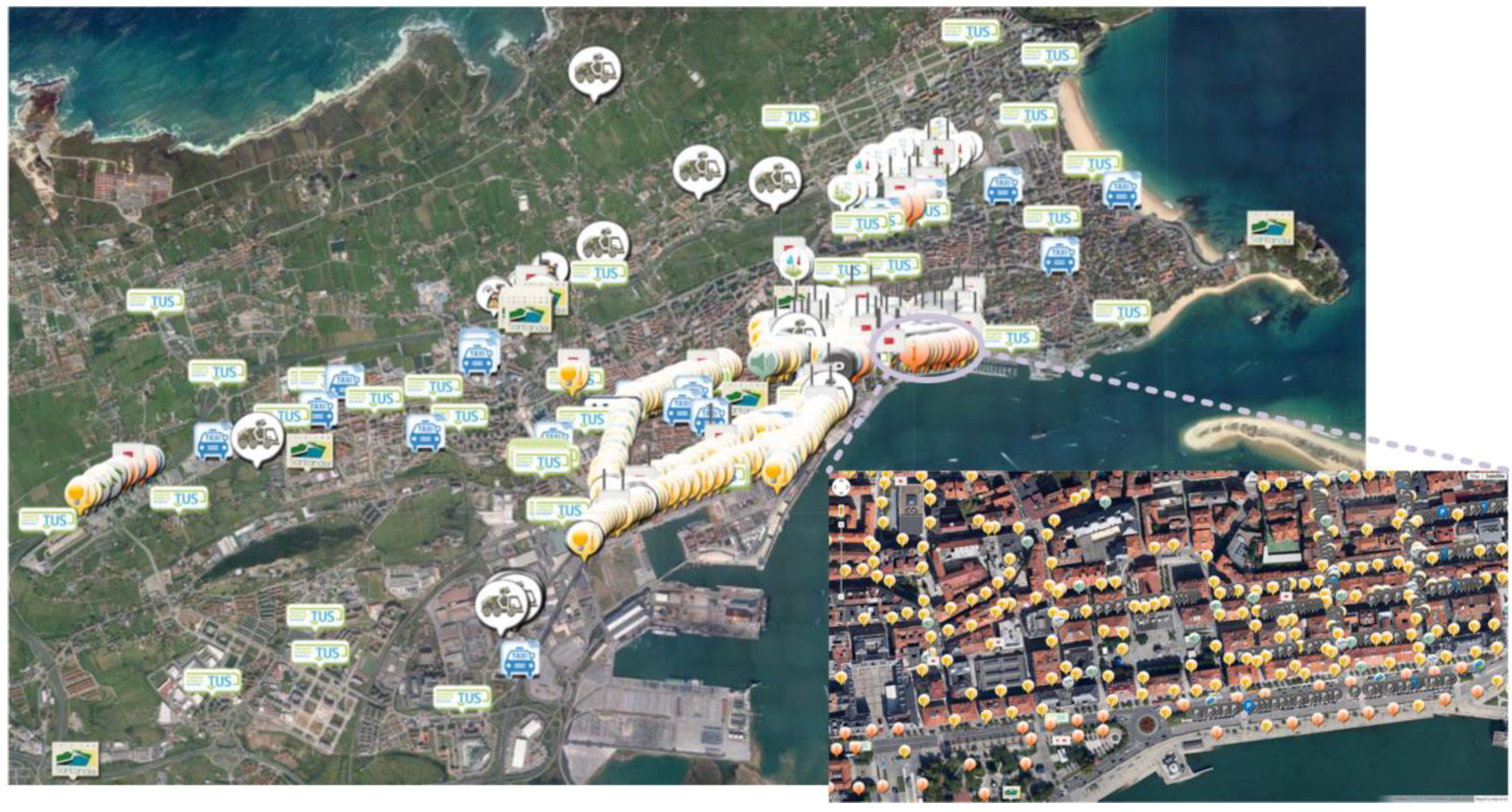
The SmartSantander testbed comprises more than 12,000 sensing devices including regular sensors, NFC tag/QR code labels, as well as smartphones from citizens. Sensors are deployed both at fixed locations (lampposts, buildings’ facades, bus stops) as well as onboard of mobile vehicles (buses, taxis). The deployment has an intentionally high density of IoT devices in the city center (a 1 km
2 area) in order to achieve the maximum possible impact on the citizens but thanks to the embarked sensors, it has the capacity to get information from most of the city extension. Every marker shown in
Figure 1 represents a sensing device which might be equipped with several sensors.
As already mentioned, the testbed, among other objectives, aims at enabling the test and validation of new IoT-based added-value smart city services. In this sense, for the deployment of the infrastructure specific application areas have been selected based on their high potential impact on the citizens. The domains of interest are:
Environmental monitoring: Fixed and mobile sensors gather observations on several phenomena related to the environmental conditions such as temperature, relative humidity, noise, air pollution, or electromagnetic fields.
Traffic conditions monitoring: Sensors installed under the asphalt at the main entrances of the city as well as magnetic loops located throughout the city are sensing road traffic parameters such as traffic volume, average speed, and queues.
Parks and gardens irrigation: Around 50 devices have been deployed in two parks to check the conditions of the grass (e.g., soil moisture and temperature) as well as weather-related parameters (e.g., rain gauge, anemometer), in order to make irrigation as efficient as possible.
Participatory sensing: Citizens are also part of the testbed. A smartphone app that is freely available allows them to report events and incidences happening in the city. Moreover, the app also has access to the built-in sensors of the smartphones (e.g., compass, GPS, noise) and it can autonomously generate observations with this information.
Outdoor parking control: Just about 400 parking sensors have been deployed under the same number of outdoor parking places located on Santander downtown streets. They are buried under the asphalt and notice the car presence featuring earth magnetic field changes detection. The devices at ground level create a self-healing mesh wireless network with those installed at nearby lampposts and facades to enable fast transmission of event messages from the vehicle detection sensors to the Gateway devices. These latter nodes form a kind of backhaul network that uses Wide Area Network (WAN) access technologies (e.g., 3G, fiber ring, etc.) to transport the information captured by the sensors towards the central repositories from which this information is actually made available to the applications and services consuming it. In addition to the sensing capacity to monitor the status of the parking places, some actuating capabilities have been also deployed. In this sense, there are 10 LED panels, installed in the monitored area, providing information about available parking places. These panels are located at street intersections, pointing towards one of the controlled streets, and indicates to the drivers if they might find a free spot in that direction or not.
Additionally, the municipality of santander already had an open data portal with over 70 data catalogues containing information on different domains of the city (public transport, water quality, cultural agenda, traffic conditions, etc.) which have been also integrated as data sources. Interestingly, for the smart parking use case, one of these catalogs relates to the available parking places at the existing underground parking garages spread around the city. These information is provided by each of the private companies that manage each of them.
It is important to note that, although the devices have been grouped as per their default domain of interest, their information is available for any application independently of its domain. For example, noise traces used to create a virtual map of quiet environments can be also used to assess traffic conditions.
3.2. Cloud and Internet of Things (IoT) -Enabled Smart City Platform
Once the sensing and actuating substrate has been presented, this section summarizes the software platform that enables the development of applications and services exploiting the information gathered and the actions supported.
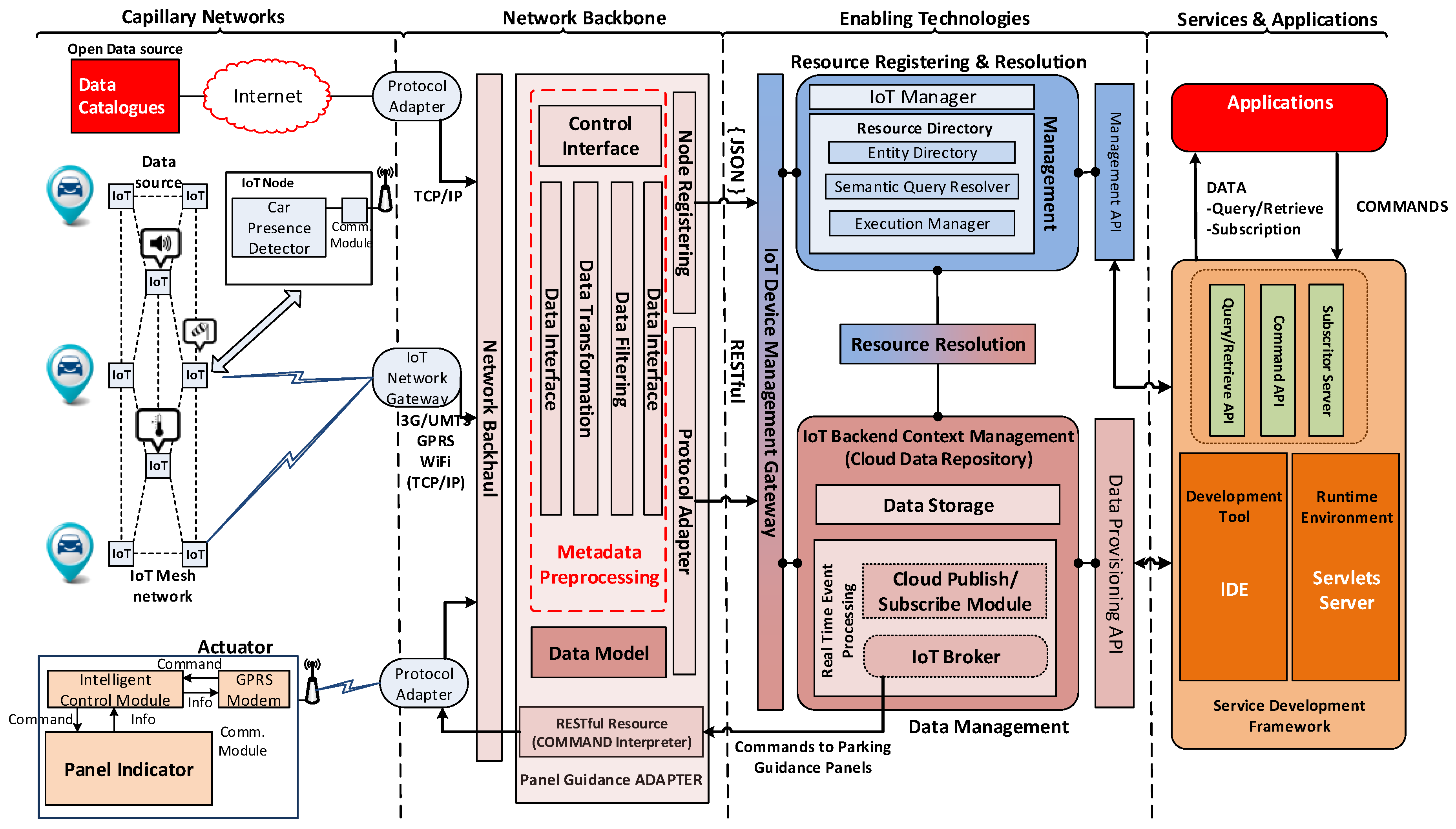
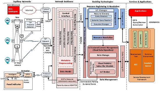
Figure 2 shows the high-level architecture of the cloud and IoT-enabled smart city platform supporting the smart parking service.
The platform has a four-tiered architecture where the capillary networks tier comprises the underlaying infrastructure formed by all the sensors, actuators and IoT devices in general. The diversity of devices and technologies is addressed in this tier. In the specific case of the Santander deployment for the smart parking service, the sensors used were all based on the same technology featuring magnetometers that detected when a car enters or leaves the monitored parking place. However, the architecture is designed to support heterogeneous deployments which can be based on video cameras or other kinds of vehicle presence detection systems. As long as the car presence observations are notified through the corresponding gateway and/or protocol adapter to the second tier of the architecture, multiple technologies can perfectly coexist at the capillary networks level.
A first level of homogenization is introduced at this level, mainly focusing on the semantics used rather than on the protocols and networks which might remain diverse. Moreover, a distinguishing aspect of the platform is that it explicitly incorporates a federated an interoperable substrate where data sources range from wireless sensor networks to crowdsourcing or open data portals. In this respect, apart from the sensors deployed at the streets, for the smart parking use case, the data about parking place availability at the indoor parking garages provided through one of the Santander open data portal catalogues is also used. This way, information about indoor and outdoor parking places can be obtained through the same application as it will be shown in the next section.
The second tier is the Network Backbone and has a twofold purpose. On the one hand, it relays information from the data sources to the cloud-based enabling technologies. The network access gateways and protocol adapters do not impose a particular wireless technology or transport protocol, but rather employ those that are available by implementing the necessary adapters. On the other hand, it completes the data modelling homogenization. Modelling of information is critical to correctly handle and integrate diverse sources of information [
30]. In this tier, corresponding meta-data is leveraged to guarantee extensibility of the platform and support for plug and play incorporation of new IoT devices or even legacy datasets and data-streams [
31]. In this sense, MetaData Preprocessing functional component of the platform provides the means for other infrastructure providers (e.g., deployments of physical, open data repositories acting as virtual sensors) to federate with the system and enlarge the catalogue of information in an interoperable manner.
The enabling technologies tier is established on the cloud and represents the core of the platform as the Sensing-as-a-Service functionality offered is provided by the functional components at this level. It is basically split in two functional groups being the first one in charge of the resource management (i.e., registration of real or virtual IoT devices, discovery of devices, etc.) and the second one exposing the underlying virtualized IoT resources through its associated IoT services. Access to data, whether historical datasets or real-time data-streams is provided. Moreover, actuation queries are also supported through this second functional group.
Last but not least, the Services and Applications tier has again a twofold objective. Firstly, it provides the tools to enable easy access to the Enabling Technologies services. Secondly, and critically important, it enables a cloud of services concept by facilitating the generation of new applications and services from software artefacts already available, creating new services by composition with those already existing.
4. Case Study: Smart Parking Trial
Modern cities traffic is one of the main challenges that municipalities have to face and it is not an easy task as it has many facets. Among them, management of limited parking including specific spaces for people with disabilities, control of load and unload areas, and traffic prediction are the most relevant elements to be considered.
4.1. Scenario Motivation
In the case of indoor parking lots, it is not unusual to have detailed information about the parking spaces availability. However, this is different when the outdoor parking areas are considered. In this latter case, similar information is rarely available. In Santander, the service of limited parking management consists in the time regulation of the parking places in the center of the city according to the municipal traffic ordinance (MTO). A private company is in charge of its control, but its services are limited to the management of the user payment management and the surveillance of parking lot usage in order to put fines to those exceeding the pre-paid parking time or parking without paying at all.
Company staff are in charge of patrolling the areas of the city where the Limited Parking is enforced checking that the cars parked have acquired the ticket and that their parking time has not expired. The information about when the ticket has been obtained is also available but this is not checked at all by the guard, thus, there is no record on the actual usage of the parking spaces but just the control of the payment of the corresponding fee. From the users’ point of view, they need to find an available parking space without any assistance just driving around on the hope of a free space.
This leads to two important drains in the overall service performance. On the one hand, human resources are spent in tedious tasks and important service information is left unobserved and consequently unexploited. On the other hand, drivers have to face the painful process, sometimes fruitless, of finding parking places without further assistance while expending precious time and fuel.
ICT technologies in general and IoT in particular, characterized by its pervasiveness, are becoming a very attractive transversal enabler in reducing carbon monoxide (CO) emissions and other pollutants, as well as petrol consumption. Ferromagnetic wireless sensors buried under the asphalt (or any other parking spaces monitoring technology) can be used to continuously monitor parking spaces status and detect when cars arrives and leaves such lots. Subsequently, this information can be gathered and made available in real-time to drivers, traffic control responsible staff and local authorities so that appropriate actions can be taken (i.e., plan the route to the nearest place, control the usage and establish policies respectively).
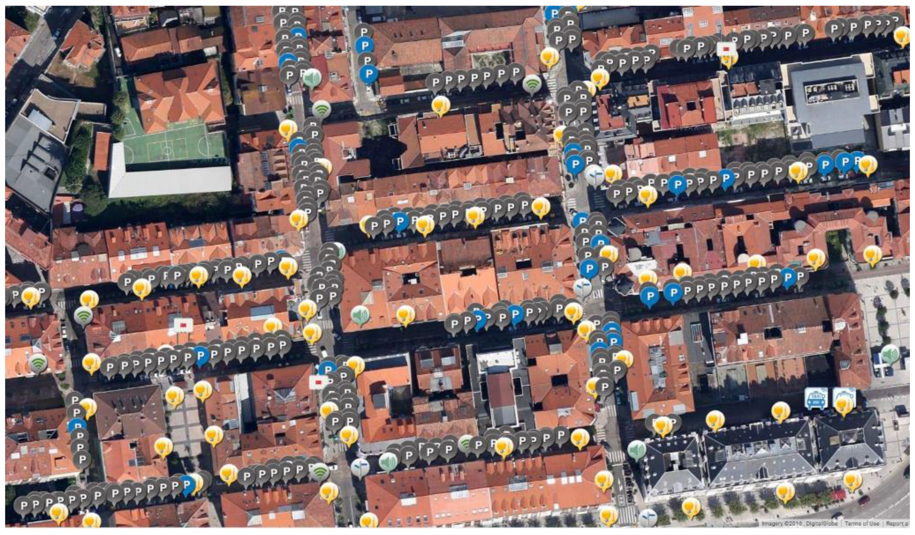
Figure 3 shows the satellite view of parking detection sensors deployed at some streets in Santander downtown area.
In this context, the deployment of such an infrastructure and making the corresponding information available is expected to: (i) make it easier for drivers to find available spaces in outdoor parking areas by informing them where and how many are available in a specific area and how to reach them (maximizing or minimizing some metrics); (ii) reduce CO emissions as well as petrol consumption; (iii) facilitate the exploitation of the parking service by allowing extracting occupancy models useful for further studies in terms of traffic prediction.
4.2. Smart Parking Service and Smartphone App
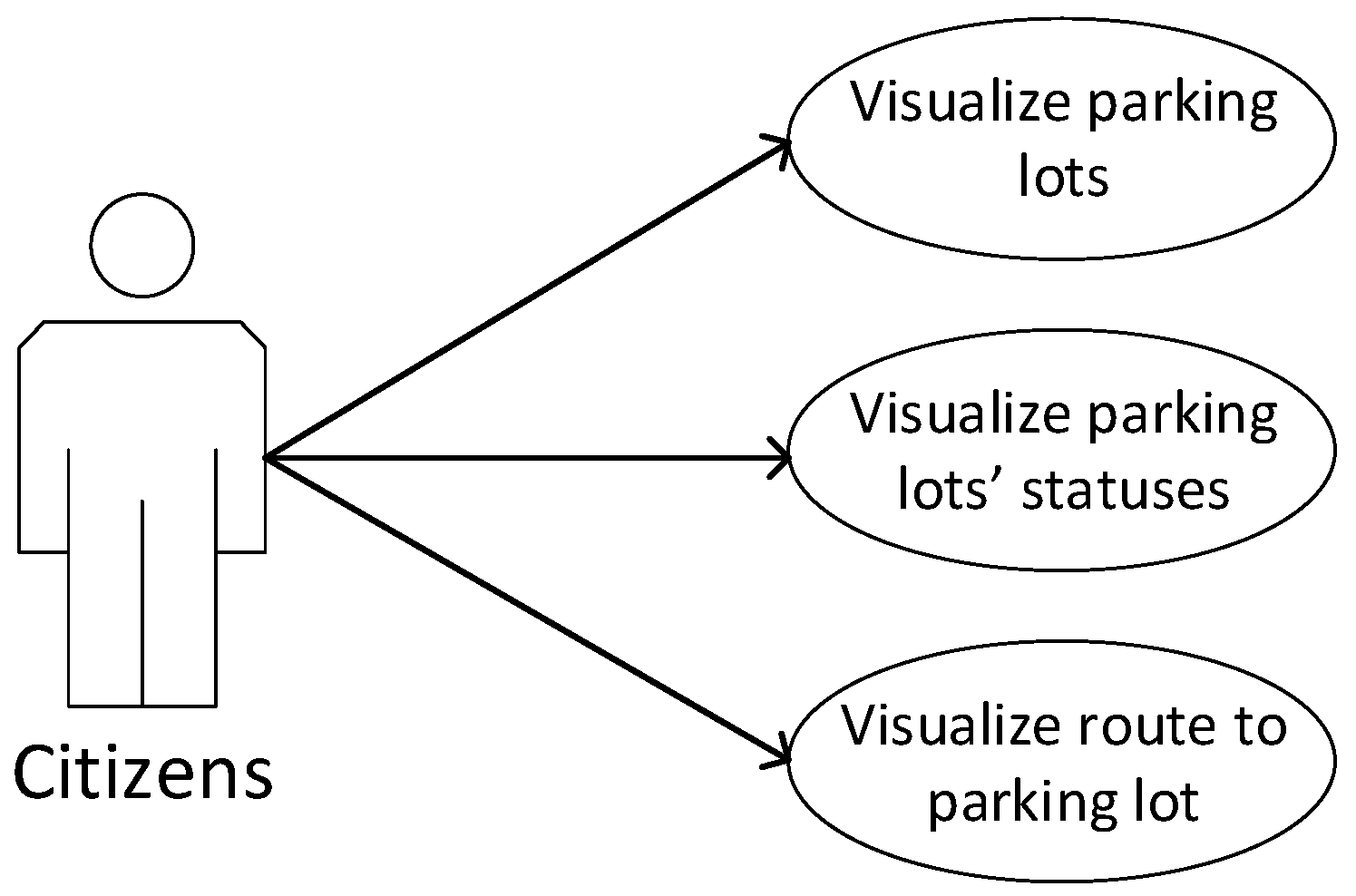
In this scenario, the user needs an overview of the real-time occupancy of certain parking areas in the city of Santander. The main use-cases that the developed smart parking application tried to cover are gathered in
Figure 4:
From their smart phones, tablets, and personal computers the citizens can check the availability of parking spaces in the city (both standard and for people with disabilities).
Citizens can also get a route to a specific parking area; so they can easily reach a certain parking area.
The smart parking application server is the component that holds the information about the parking availability. It interacts with the smart city platform subscriptor server (
Figure 2 at the services and application tier) component through an asynchronous publish-subscribe mechanism; i.e., it subscribes for events regarding parking sensors. From these subscriptions, it receives notifications whenever there is a change of availability in one of the parking spaces. On consuming this event, the parking server updates its data by setting the availability of a parking space to free or occupied according to the event received.
The connection between the smart parking application server and the mobile client is done through a Web Service interface the smart parking application server provides. The mobile client can request the specified parking lots availability/occupancy as well as get immediate notifications about just freed spots together with a route to them.
Three mobile applications have been developed: one for the iOS platform; one for the Android platform; and one for the Windows mobile platform. The three applications have similar functionalities and usability.
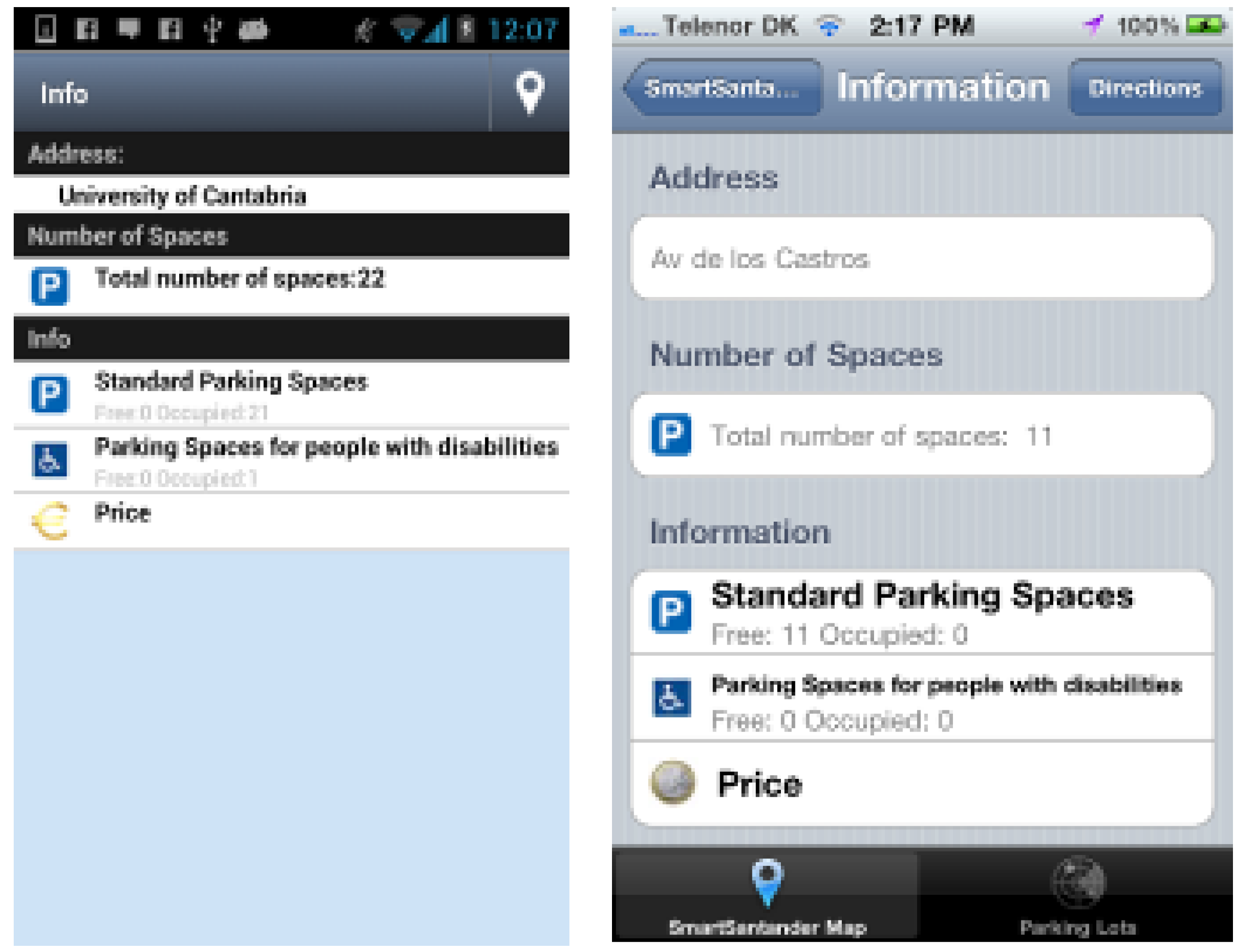
When the smart parking application starts it sends a request to the server for getting the list of parking lots and its availability. The application displays in a map the information received. The user can also see the parking lots organized in a list ordered by current distance. For visualizing the current occupancy status of a certain parking lot, the user can click on the parking lot he/she wants. A detailed view of the parking lot is loaded as it can be seen in
Figure 5. Additionally, the user can subscribe to be notified of the release of a parking lot in its surroundings (establishing through the application the radius from its current location). Moreover, users can get a route from their current location to that parking lot. On clicking on this button, the maps application of the phone is loaded with the route(s) to the parking lot; this functionality is very useful for the users that are, for instance, visiting the city and do not know the roads.
Last but not least, in order to improve the overall service usability, 10 guiding panels have also been deployed which inform drivers about the available places depending on which route they choose. The smart parking application server makes use of the command application programming interface (API) (
Figure 2 at the services and application tier) to issue the commands that makes these panels dynamically change the information displayed on them.
4.3. Field Trial Assessment
In order to improve, the main expected improvements in this scenario are: (i) making it easier for the driver to find free places in outdoor parking areas by informing her/him where and how many are available in a specific area and how to reach them (maximizing or minimizing some metrics); and (ii) easing the use of the parking service by allowing the extraction of occupancy models useful for further studies in terms of traffic prediction.
In order to evaluate the limited parking scenario from the perspective of the previous indicators, statistical data obtained from the company in charge of its management were analyzed. The details about these indicators were marked as confidential by the parking management company and, thus, cannot be presented in this paper.
The main conclusions that were extracted from the various meetings that were held to better understand current practices and parking service management experience was that the data collection methodology could be greatly improved by using the automated process (IoT devices) provided by SmartSantander (Santander, Spain). The data included from the report was collected manually, once every 15 days, by the guards who supervise each area in the city. The method basically consists of counting the places in a specific area and subtracts the result from the available places in that zone. Based on the obtained result the occupancy average is calculated.
Taking into account the aforementioned aspects, the selected KPIs are shown in
Table 1.
In contrast, the information collected by sensors deployed in SmartSantander allows us to make a detailed study of each of the parking places either alone or taking sets of streets, areas, or various other approaches. Data collection can be equally bounded temporarily at different levels of granularity, i.e., from a concrete day to weekly, monthly, or yearly periods. Last but not least, the infrastructure can be easily extended to support electrical mobility by providing real time information about recharging point’s availability.
Table 2 presents the key service features that were compared within the deployed field trial and presents the conclusions that were reached through the analysis made together with the parking management company experts.
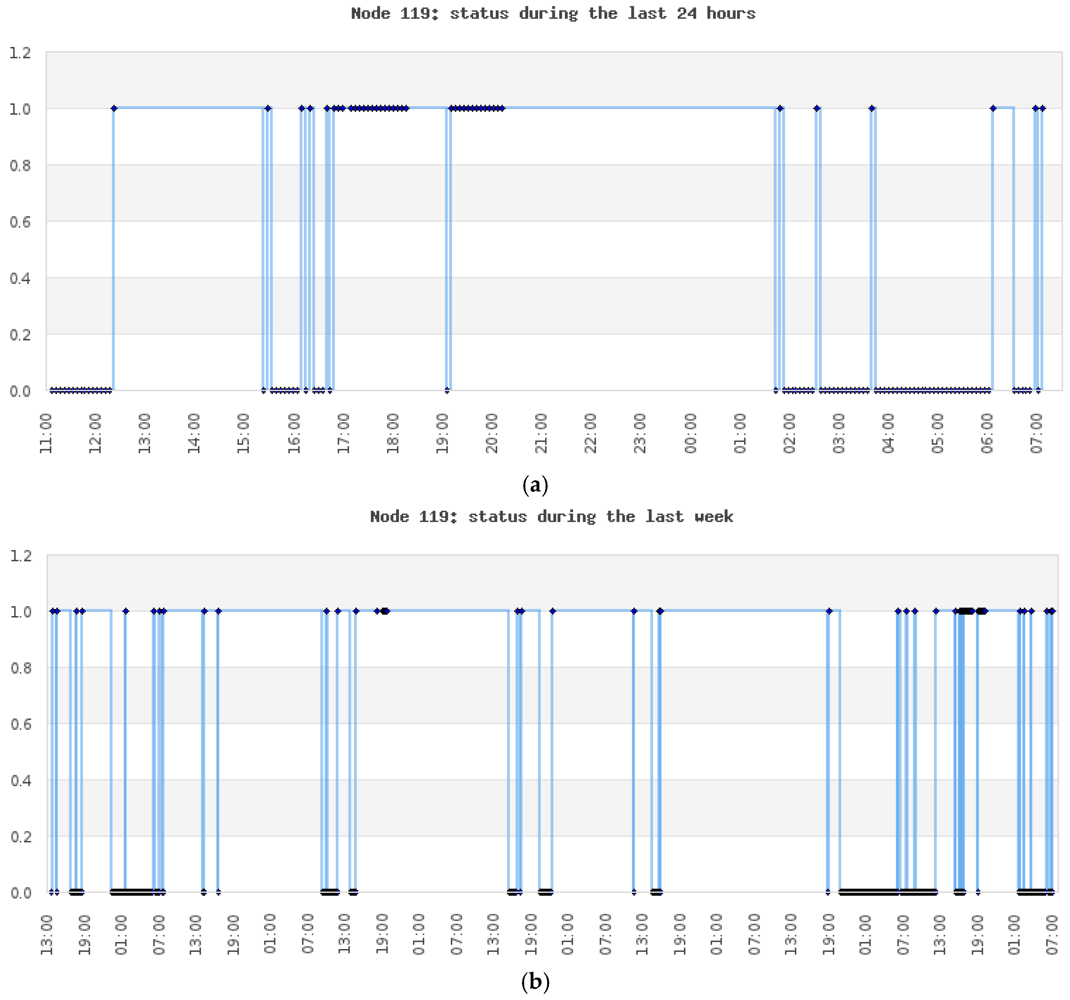
Additionally, although not included within the field trial described in this paper, further usage of data mining techniques would offer lots of useful information about the degree of occupation of the area under study as well as potential problems of congestion at different times or dates. In this sense, the Services and Applications tier could host pre-defined algorithms which can directly offer post-processed information. Developers of such processing engines can use the platform itself to host these services so that on the one hand they have the necessary cloud-computing tools to support their modules, and, on the other hand, they benefit from the platform critical mass in terms of attracting consumers of such value-added data. This is something that the manager of the concessionaire company recognized and they showed a great interest in the adoption of these methodologies.
As an illustrative example,
Figure 6 shows the kind of analysis that can be carried out for any IoTized parking space in the city. As it can be seen, the number of times and the exact time when a parking space changes its status (from occupied to free and vice versa) can be tracked down.
This raw data can be available to parking lot forecasting models such as the ones described in [
32,
33]. Specifically, Vlahogianni et al. [
34] took the raw data that is presented in
Figure 6 and used it within different mathematical models to get the probability of a parking space to continue to be free in the forthcoming time intervals or to predict parking occupancy rates up to 30 min in the future by exploiting 1-min data.
This digested information can be used to enhance the parking experience of users. Moreover, this kind of prediction techniques could also be exploited by the municipality to implement smart policies on the parking spaces of the city and integrate this knowledge into a holistic management of the city traffic.
5. Conclusions
This paper presents a field-trial case based on the smart parking application and service which were developed and run on top of a cloud and IoT-based smart city platform. Moreover, the paper introduces the high-level architecture for this platform. It addresses key smart city paradigm requirements and enables the development of added-value services, like the one introduced in the article, by integrating in its design, concepts of IoT, and cloud technologies.
This work shows that the value of IoT infrastructures is only leveraged by the ability to virtualize the underlying complexity through well-defined interfaces and enablers that enable easy development and instantiation of services and applications that makes use of the data generated and accesses the actuation capabilities of the myriad of devices that coexist in the smart city ecosystem. Additionally, by implementing a smart solution for one of the most demanded smart city service, namely parking, in this work it has been possible to carry out an assessment of the benefits that the wide-scale introduction of this kind of solutions can bring to the cities of the future.
In conclusion, this paper provides a review of the implementation and assessment of a prototype smart parking service supported by real-world large-scale IoT infrastructure and the results showed that this kind of service can bring important benefits in the efficiency of currently run services. No detailed analysis of the impact of the solution is provided since the contribution of the paper is to present how a holistic ICT-based platform is able to support the development and deployment of smart services in a real city environment. Particularly, through the actual implementation and deployment of a smart parking use case in a real-world scenario. The integrated approach introduced in this work would serve as a proof-of-concept for development of novel smart city services in the near future tacking additional services linked to efficient use of renewable energies, electrical mobility, and gamification and rewarding mechanisms.
In addition to the direct feedback that is provided to the drivers through the installed panels or mobile devices (e.g., smartphone or GPS receiver) as described in this article, having access to this information and being able to correlate it with other existing datasets in a homogeneous way enable further extension of the smart parking case to a more holistic smart city traffic management use case that provides intelligent transportation services such as multi-modal routing and location-based information to mobile and Web users. Future work encompasses the development of a service to allow users to make smarter travel choices to get to their destinations, reducing the time spent driving through the streets and avoiding, as much as possible, congestion and occasional incidents on the streets. This will be achieved providing users with reliable, real-time information on the traffic situation throughout the city. A system of models including a flow estimation model, a traffic assignment model and a parking dynamics model fed by the traffic and parking status data provided by the smart city platform will generate the situation on top of which smart decisions can be made.


 ,
, 

