Article

Exploration of Shallow Geothermal Resources Based on Gravity and Magnetic 3D Inversion in the Wudalianchi–Laoheishan Volcano and Surrounding Areas

1
College of Geo-Exploration Science and Technology, Jilin University, Changchun 130026, China
2
Key Laboratory of Applied Geophysics, Jilin University, Ministry of Natural Resources, Changchun 130026, China
3
Jilin Co., Ltd. of China National Building Materials Resources and Environmental Engineering, Changchun 130033, China
4
Guangxi Bureau of Geology & Mineral Prospecting & Exploitation, Nanning 530023, China
*
Author to whom correspondence should be addressed.
Energies 2025, 18(8), 2011; https://doi.org/10.3390/en18082011
Submission received: 26 January 2025 / Revised: 20 March 2025 / Accepted: 10 April 2025 / Published: 14 April 2025
(This article belongs to the Section H2: Geothermal)

Abstract

:
Geothermal resources represent one of the most vital renewable energy sources, offering substantial development potential within the energy sector. Wudalianchi, renowned as one of China’s prominent volcanic clusters, has undergone extensive underground volcanic activities, suggesting a promising capacity for geothermal resource accumulation. This paper is the first to apply the cross-gradient gravity-magnetic joint inversion method to study the shallow structures in the Laoheishan Volcano and surrounding areas of Wudalianchi, based on high-precision measured gravity and magnetic data. The inversion results indicate the presence of a rock body at a depth of approximately 2 km beneath the Laoheishan and Bijiashan regions, which simultaneously exhibits characteristics of low density, high magnetization, and low seismic velocity. Integrating previous research findings, the rock body is interpreted as basalt formed during magmatic activity, retaining remanent magnetism. Furthermore, the rock body contains fractures filled with fluids, thereby excluding the possibility of a shallow magma chamber or dry hot rocks beneath the Laoheishan area. These rock bodies are interconnected at depth and align with the NE and SE fault directions in the Wudalianchi area, confirming that these faults govern the region’s volcanic activities. The inversion results, from the perspectives of density and magnetic susceptibility, elucidate the material distribution in the shallow subsurface of the Laoheishan and surrounding areas, providing new evidence for further exploration of geothermal resources in the region.

1. Introduction

During past industrial development, humanity has heavily relied on coal, oil, and other non-renewable energy sources. However, with the advancement of the economy and technology, the demand for energy has been steadily increasing. The energy crisis has become a significant challenge faced by nations worldwide. To ensure the sustainable development of future energy supplies and to address the energy crisis, attention has shifted towards renewable energy sources. Geothermal resources, comprising renewable thermal energy generated and stored beneath the Earth’s surface, are among the most crucial renewable energy sources. Geothermal resources can be classified into three categories based on temperature range and utilization methods: shallow geothermal resources, hydrothermal geothermal resources, and hot dry rock geothermal resources [1]. The development and utilization of technologies for shallow geothermal energy and hydrothermal energy have become relatively mature. However, hot dry rock geothermal resources, as deep geothermal resources, are typically buried at depths of 3–10 km, making exploration and development more challenging. The deep heat reservoirs corresponding to hot dry rocks generally consist of high-temperature rocks with temperatures exceeding 150 °C and very little or no water content. Notably, the energy reserves of these rocks are equivalent to 30 times the combined energy contained in all the world’s oil, natural gas, and coal resources [2,3]. Geothermal resources, especially hot dry rocks, are receiving increasing attention worldwide, and there have been many successful cases of their development and utilization. China is a country with abundant geothermal resource potential, with a wide distribution and massive reserves of geothermal energy [4]. In recent decades, China has made significant achievements in the exploration of hot dry rocks, especially in areas such as the Gonghe Basin, Songliao Basin, and the southeastern coastal regions, where major breakthroughs and progress in hot dry rock exploration have been made [5,6,7,8,9,10].
Gravity exploration and magnetic exploration are commonly used methods in mineral resource exploration. These methods are based on the differences in the density and magnetic susceptibility of underground rocks to obtain gravity anomaly data and magnetic anomaly data. Subsequently, through density inversion and magnetic susceptibility inversion, the location, distribution, shape, and physical dimensions of ore bodies can be analyzed and quantified. Gravity and magnetic exploration hold extensive application prospects in geothermal exploration. In 2015, Nouraliee et al. performed gravity 3D inversion based on gravity data from the Mahallat geothermal field in the Markazi Province of Central Iran to infer high-potential geothermal reservoir zones [11]. In 2016, Mohammadzadeh Moghaddam et al. inferred the depth and extent of the geothermal system in the Delijan region of Central Iran based on Euler depth estimation and 3D inversion of magnetic and gravity data, providing favorable conditions for future geothermal exploration drilling [12]. In 2018, Xi et al. used wavelet multi-scale decomposition on Bouguer gravity data from Guangdong Province to identify granite ore bodies associated with underground heat sources [13]. In 2020, Lewerissa et al. applied gravity and magnetic methods to establish a geological model of the subsurface at the Suli and Tulehu geothermal fields in Indonesia. Based on the inversion results, they inferred that the underground mineral bodies with low density and susceptibility contrast correspond to geothermal reservoirs [14]. In 2020, Pocasangre et al. conducted 2D gravity inversion and 3D gravity modeling using gravity data in the Municipality of Isa, Japan. They inferred the location and extent of the subsurface geothermal reservoirs and estimated the potential energy value of the subsurface geothermal reservoirs [15]. In 2023, Zhao et al. used the 3D gravity focusing inversion method to obtain a high-precision density distribution model of the subsurface in the Gonghe Basin and inferred the presence of a subsurface molten layer [16].
Large-scale volcanic activity is one of the important favorable conditions for the formation of geothermal resources. Many geothermal exploration and development projects around the world are carried out in volcanic regions and their surrounding areas. Research on volcanic geothermal systems has also been advancing under this wave, continuously expanding our understanding of volcanoes from the perspectives of geology, geophysics, chemistry, environment, and other disciplines. Bullard E C and Benfield A E first conducted heat flow measurements in 1939 [17,18]. With the improvement of methods and technologies for terrestrial heat flow measurement, the number of valid global terrestrial heat flow data points reached 38,400 by 2013 [19]. In 1966, Fourinier et al. established a series of geothermal thermometry formulas and determined the prerequisites based on the applicability of each formula [20]. Over the years, these formulas have been continuously refined, and the geothermal thermometry method has been widely applied in estimating the reservoir temperatures of geothermal fluids. In 1988, Giggenbach integrated the Na-K and K-Mg thermometers to propose the Na-K-Mg ternary diagram, providing a basis for analyzing the degree of interaction between fluids and reservoir rocks as well as the sources of geothermal fluids [21]. These methods, along with the geophysical methods mentioned earlier, have been continuously improved and applied, providing a foundation for volcanic geothermal exploration. China’s volcanic geothermal exploration has also been enriched over the years, focusing on major volcanic regions such as the Tengchong volcanic area, Changbai volcanic area, and Wudalianchi volcanic area. Through various means such as hydrogeochemistry, geological structures, geothermal thermometry, and geophysical exploration, a comprehensive understanding of the geothermal systems in China’s typical volcanic regions has been achieved [22,23,24,25,26,27].
The Wudalianchi region is a famous volcanic activity site in China, which has experienced multiple eruptions since the Quaternary period. The youngest volcanoes in the area, Laoheishan and Huoshaoshan, erupted between 1719 and 1722, only 300 years ago. This suggests the possibility of magma residual heat and the existence of geothermal resources in the form of hot dry rocks [28]. In previous investigations, the Wudalianchi region has accumulated a wealth of results from various geological survey methods. However, there are fewer inversion results from gravity and magnetic exploration, with most of the existing results being based on single physical property inversions [29,30]. The existence of shallow geothermal resources in Wudalianchi has always been an intriguing question worthy of research. This paper is the first to apply the gravity-magnetic joint inversion method in the Laoheishan Volcano and surrounding areas of Wudalianchi, obtaining the three-dimensional density and magnetic susceptibility structural characteristics of the shallow subsurface region. By integrating previous geological understanding and research findings on this area, the paper identifies the existence of shallow cooling magma chamber beneath the Laoheishan Volcano and explores the subsurface physical property distribution, geological structure, and the potential for hot dry rock.

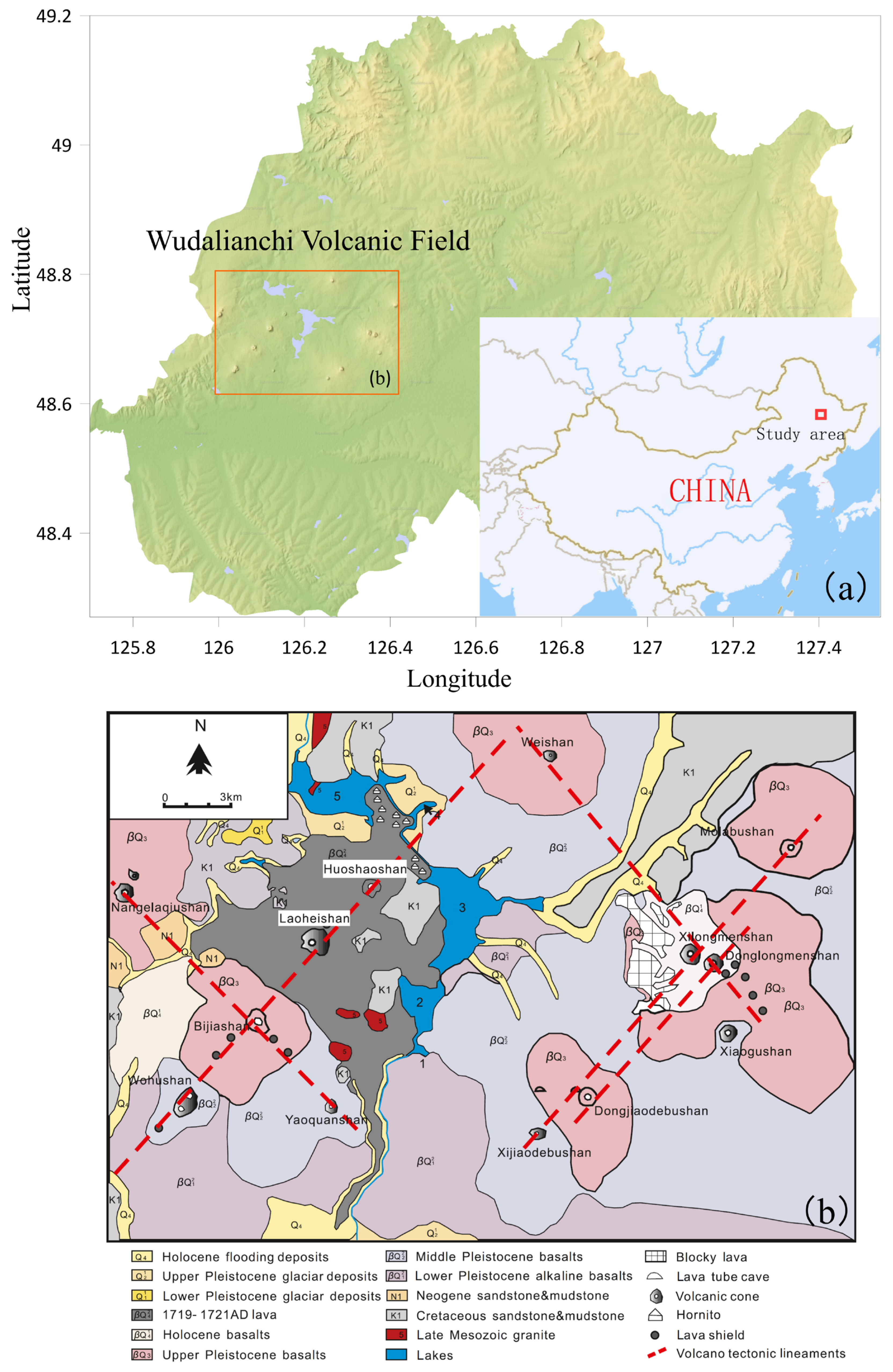
2. Geological Setting

Wudalianchi is a renowned volcanic region in China, with a total of 14 volcanic cones within its area, primarily controlled by NE-trending and NW-trending faults. The distribution of faults is aligned along the connections between different volcanoes, forming a grid-like fault pattern, as shown in Figure 1. These faults were formed before the volcanic activity in the Wudalianchi area and provided upward pathways for magma during volcanic eruptions [31]. According to the geological map of Wudalianchi (Figure 1), the relationship between volcanic rocks and strata of different geological ages in the Wudalianchi area is complex. The basement is primarily composed of Cretaceous mudstones, siltstones, and sandstones, as well as biotite granites. The volcanic rocks of the volcanic group are primarily potassium-rich alkaline basalts. Due to differences in the eruption times of the volcanoes, basalt flows from the Upper Pleistocene to Holocene cover the surface in different areas. Laoheishan and Huoshaoshan, with the most recent eruptions, are covered by a large amount of volcanic lava on the surface [32,33].
Over the years, many geologists have conducted geophysical exploration in the Wudalianchi area. In 1997, the Institute of Geology of the China Earthquake Administration and the Heilongjiang Provincial Seismological Bureau completed geomagnetic observations in the Wudalianchi volcanic area. Zhan et al., through various processing methods, continuously enhanced their analytical understanding of the region. They concluded that along the Wohushan—Bijiashan—Laoheishan—Huoshaoshan line, there exists a high-resistance body that is wide at the top and narrow at the bottom, extending from the surface to a depth of about 15 km. In contrast, below the area along the Weishan and its southeastern side, including the Dongxi Jiaodebushan, Xiao Gushan, and Longmenshan lines, the medium exhibits low-resistance characteristics at a depth of several hundred meters [35,36]. In 1999, Zhao et al., with the help of geomagnetic research, conducted a series of geophysical inversions. They inferred the existence of a magma chamber in the Wudalianchi volcanic area, with ancient volcanoes having fully solidified, while modern volcanoes had not yet completely solidified [37]. In 2013 and 2018, Gao et al. analyzed and calculated the seismic body wave Q-value characteristics in the Wudalianchi region, speculating that there is no large volume of magma beneath the Wudalianchi volcanic group. This supported the conclusion that the magma chamber in the Wudalianchi area is nearly completely solidified [38,39]. In 2016, Zhang et al. used the microseismic method to obtain the velocity structure characteristics of the Wudalianchi Weishan area at depths ranging from 0 to 700 m [40]. In 2016, Li et al. conducted high-resolution environmental noise tomography using a dense seismic array consisting of 43 seismometers. They found that beneath the Weishan Volcano, there is a possible hot dry rock reservoir that exhibits both high conductivity and low wave velocity characteristics. They suggested that the Laoheishan and Huoshaoshan volcanoes still have the potential for eruption. At a depth of 8 km, there may be a magma conduit that connects to the deeper magma, providing magma supply to the Wudalianchi volcanic area [41]. In 2017, Zhang et al., combining results from gravity and magnetic surveys, natural earthquakes, and geomagnetic depth sounding, inferred the presence of a cooling magma chamber in the deep part of the Weishan area in Wudalianchi. They based this on the physical characteristics of dry hot rock, such as high electrical conductivity, low wave velocity, and significant gravity and magnetic anomalies, and estimated its possible burial depth and shape. They believed that the underground conditions at Weishan are favorable for the formation of dry hot rock [42]. In recent years, other related geological studies have also been carried out. In 2005, Peng et al. conducted a study on the dynamic stability of the Laoheishan and Huoshaoshan regions, concluding that there is a magma chamber underground, but it is nearly completely solidified [43,44]. In 2013, Lu combining previous research on the geological structure, surface anomalies, geothermal gradients, geophysical fields, remote sensing, seismology, and temperature scales of the Wudalianchi volcanic area, conducted a comprehensive analysis and proposed that magma chambers exist within the crust of the Wudalianchi region [45,46].
Despite the numerous research findings, there is still no definitive conclusion regarding the existence of underground magma chambers and geothermal resources in the Wudalianchi area. The current main research conclusion suggests that the magma chamber in the shallow area of Wudalianchi has already cooled, making the possibility of dry hot rock formation relatively low. However, there may be a large amount of dry hot rock geothermal resources in the deep magma channel, though exploration and development would be challenging. Based on the results of gravity-magnetic joint inversion using the cross-gradient method, this paper will analyze and interpret the findings from the gravity and magnetic perspectives, providing a new viewpoint for geothermal resource exploration in the region.

3. Gravity and Magnetic 3D Joint Inversion Method

Traditional inversion methods divide the underground space into grids. The finer the grid division, the higher the accuracy of the inversion results, but the computational load also increases accordingly. To improve inversion efficiency, researchers have focused on enhancing various algorithms to speed up the computation process [47,48,49], while also improving the grid generation methods to increase efficiency [50,51]. However, traditional gravity and magnetic inversions, as well as geophysical inversions in general, still rely on single physical property inversion. The issue of non-uniqueness remains a significant challenge. As a result, joint inversion of multiple geophysical data sets has emerged, and over the years, it has made significant progress and gradually matured [52,53,54,55,56]. The joint inversion of gravity data and magnetic data is mainly divided into two aspects: physical property constraints and structural constraints. The physical property constraint relies on prior information. In 2006, Bosch et al. used gravity and magnetic data, along with prior information on density and magnetic susceptibility, to analyze the subsurface physical property structure [57]. When prior information is insufficient, the structural similarity of the physical property model can be used as a constraint. In 2009, Fregoso implemented a 3D cross-gradient joint inversion of gravity data and magnetic data, obtaining more accurate results than individual inversions [58].
This paper is mainly based on the regularization inversion theory proposed by Soviet scientists Tikhonov and Arsenin [59]. It selects different model fitting conditions as regularization terms based on different prior information to address the two challenges in inversion: instability and non-uniqueness of solutions [60,61]. Based on different prior geological information, various model fitting conditions (i.e., stability functions) are chosen as regularization terms to obtain inversion results with different characteristics. This paper selects the simplest model fitting condition—the minimum model constraint condition—as the regularization term. The main factors affecting the effectiveness of regularized inversion include model fitting conditions, model weighting functions, methods for constraining physical parameters, and the range of physical parameter constraints.
The principle of regularized inversion is to divide the subsurface into M regular cubes, with N observation points on the surface. The relationship between the field observations and the physical parameters is generally linear:
d = A m
The column vector d represents the surface observation data, which can be any type of field data, and its dimension is N; the column vector m represents the physical parameters, and its dimension is M; the matrix A denotes the forward operator connecting the observation data d and the physical parameters m, and is an N × M matrix. When d represents observed gravity data, m represents the density parameter ρ; when d represents observed total magnetic anomaly intensity data, m represents the magnetization strength parameter M (or the magnetization susceptibility parameter κ, with κ being proportional to M).
ϕ = A m d 2 = A m d T A m d
After introducing the minimum model constraint regularization term and the cross-gradient constraint term, the objective function for the inversion problem can be written as follows:
ϕ = ϕ d + α ϕ m + ϕ c r o s s = A m d 2 + α m 2 + τ x , y , z = A m d T A m d + α m T m + m 1 x , y , z × m 2 x , y , z
ϕ c r o s s = τ x , y , z = m 1 x , y , z × m 2 x , y , z
τ x ( x , y , z ) = m 1 ( x , y , z ) y m 2 ( x , y , z ) z m 1 ( x , y , z ) z m 2 ( x , y , z ) y τ y ( x , y , z ) = m 1 ( x , y , z ) x m 2 ( x , y , z ) z m 1 ( x , y , z ) z m 2 ( x , y , z ) x τ z ( x , y , z ) = m 1 ( x , y , z ) x m 2 ( x , y , z ) y m 1 ( x , y , z ) y m 2 ( x , y , z ) x
In this expression, ϕ d is the data fitting term, ϕ m is the model fitting term, and ϕ c r o s s (or τ x , y , z ) is the cross-gradient constraint term, with components τ x x , y , z , τ y x , y , z , and τ z x , y , z . m 1 and m 2 represent the gradients of the two physical properties, specifically density and magnetic susceptibility. α is the regularization parameter, and its value in this paper is determined using the L-curve method. By plotting the relationship curve between the data fitting term ϕ d and the regularization term ϕ m as the regularization parameter α varies, the inflection point of the curve typically corresponds to the optimal regularization parameter α.
After introducing the reference model, the objective function can be expressed as follows:
ϕ = ϕ d + α ϕ m + τ x , y , z = A m m p r e d A m p r e T A m m p r e d A m p r e + α ( m m p r e ) T m m p r e + m 1 ( x , y , z ) × m 2 ( x , y , z )
m pre is the reference model determined based on prior information, which is generally set to 0 when prior information is insufficient. Since different physical parameters have varying impacts on the observed data and the accuracy of different observed data also varies, to balance these differences, the model weighting matrix W m and the data weighting matrix W d are introduced into the objective function. The objective function is then rewritten as follows:
ϕ = ϕ d + α ϕ m + τ x , y , z = W d A m m p r e d A m p r e T W d A m m p r e d A m p r e + α W m m m p r e T W m m m p r e + m 1 x , y , z × m 2 x , y , z
The data weighting function W d has a relatively minor impact on the solution, but the model weighting function W m has a significant effect on the inversion results. The commonly used model weighting function is the depth weighting function W z , which is based on the depth weighting theory proposed by Li and Oldenburg [62,63]. Its diagonal elements are related to the depth of small cubic cells. The weight w z x , y , z for blocks at the same depth is constant and independent of the horizontal position. This method effectively mitigates the “shallow effect” in the inversion results. The expression is written as follows:
w z x , y , z = 1 ( z + z 0 ) β / 2
where β is the fitting index. In this paper, for gravity data, the kernel function β is set to 2, and for magnetic data, β is set to 3. Finally, the optimal solution for the objective function is obtained using an optimization algorithm to derive the inversion results.

4. Wudalianchi Measured Data Processing

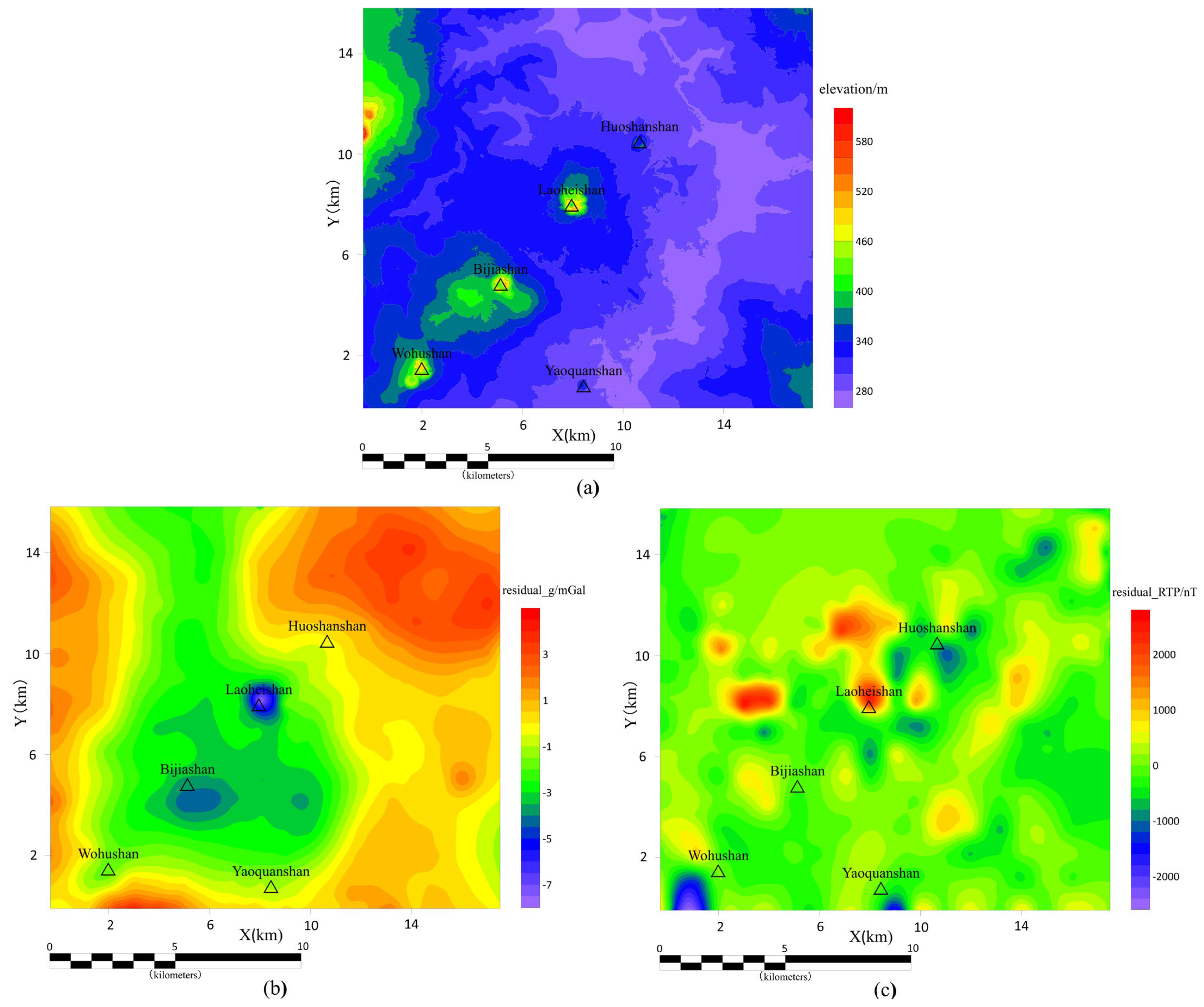
4.1. Details of the Gravity Data and Magnetic Data

The gravity and magnetic data used in this study were obtained from field measurements of the Laoheishan Volcano and surrounding areas in the Wudalianchi region. The overall scale of the data is 1:100,000, with some local areas having a scale of 1:50,000. The raw gravity and magnetic data obtained from measurements require certain preprocessing before they can be used for further interpretation and inversion. For preprocessing, this paper utilizes the commonly used geophysical software Oasis montaj 7.3. For gravity data, it is necessary to complete terrain correction, latitude correction, elevation correction, and intermediate layer correction to obtain Bouguer gravity anomaly data. For magnetic data, diurnal variation correction, normal gradient correction, and height correction are required to obtain the corrected magnetic anomaly data. The acquired gravity and magnetic data are gridded using appropriate methods, followed by continuation and field separation to obtain residual Bouguer gravity anomaly data (referred to as residual_g) and residual magnetic anomaly data (referred to as residual_RTP), which reflect the characteristics of shallow anomalies, as shown in Figure 2. It is particularly noted that the magnetic anomaly data underwent magnetic pole reduction processing before continuation to eliminate the effects of oblique magnetization and better correspond to the actual geological bodies.
From the elevation map of the survey area (Figure 2a), it can be observed that the volcanic peaks of Huoshaoshan, Laoheishan, Bijiashan, and Wohushan are roughly aligned along a northeast-southwest line. The overall elevation of the survey area decreases from southwest to northeast. The residual Bouguer gravity anomaly map of the survey area (Figure 2b) indicates a significant low-gravity anomaly in the Laoheishan-Bijiashan region. The residual gravity anomaly is centered around the Laoheishan-Bijiashan area and gradually increases outward. Although Huoshaoshan, Wohushan, and Yaoquanshan exhibit low gravity anomalies, the anomaly values are not prominent enough. From the residual magnetic anomaly map of the survey area (Figure 2c), it can be observed that the magnetic anomaly distribution in the area is complex. Laoheishan is located at the center of a local high magnetic anomaly, while Huoshaoshan is situated at the center of a local low magnetic anomaly. The magnetic anomalies alternate between positive and negative values across the different volcanic regions. From the overall magnetic anomaly distribution in the survey area, the Huoshaoshan-Wohushan line is located in a low magnetic anomaly zone, with high magnetic anomalies on both sides, forming an NE-trending high-low-high magnetic band. This distribution aligns with the direction of the NE-trending faults that control the development of the volcanoes. The magnetic anomaly characteristics of volcanoes generally show a pattern of low anomalies at the volcanic center, higher anomalies at the volcanic crater’s edge, and a rapid decrease toward the surrounding areas. Additionally, the thickened volcanic cover weakens the magnetic properties of the underlying basement, resulting in an overall relatively negative magnetic field in the volcanic area. This phenomenon explains why the Huoshaoshan-Wohushan line in the survey area is in a low magnetic anomaly zone, with high magnetic anomalies on both sides. The localized high magnetic anomaly at Laoheishan is likely due to the fact that Laoheishan is a Cenozoic volcano that has experienced a significant eruption, resulting in a large volume of rocks carrying remanent magnetism beneath the surface.

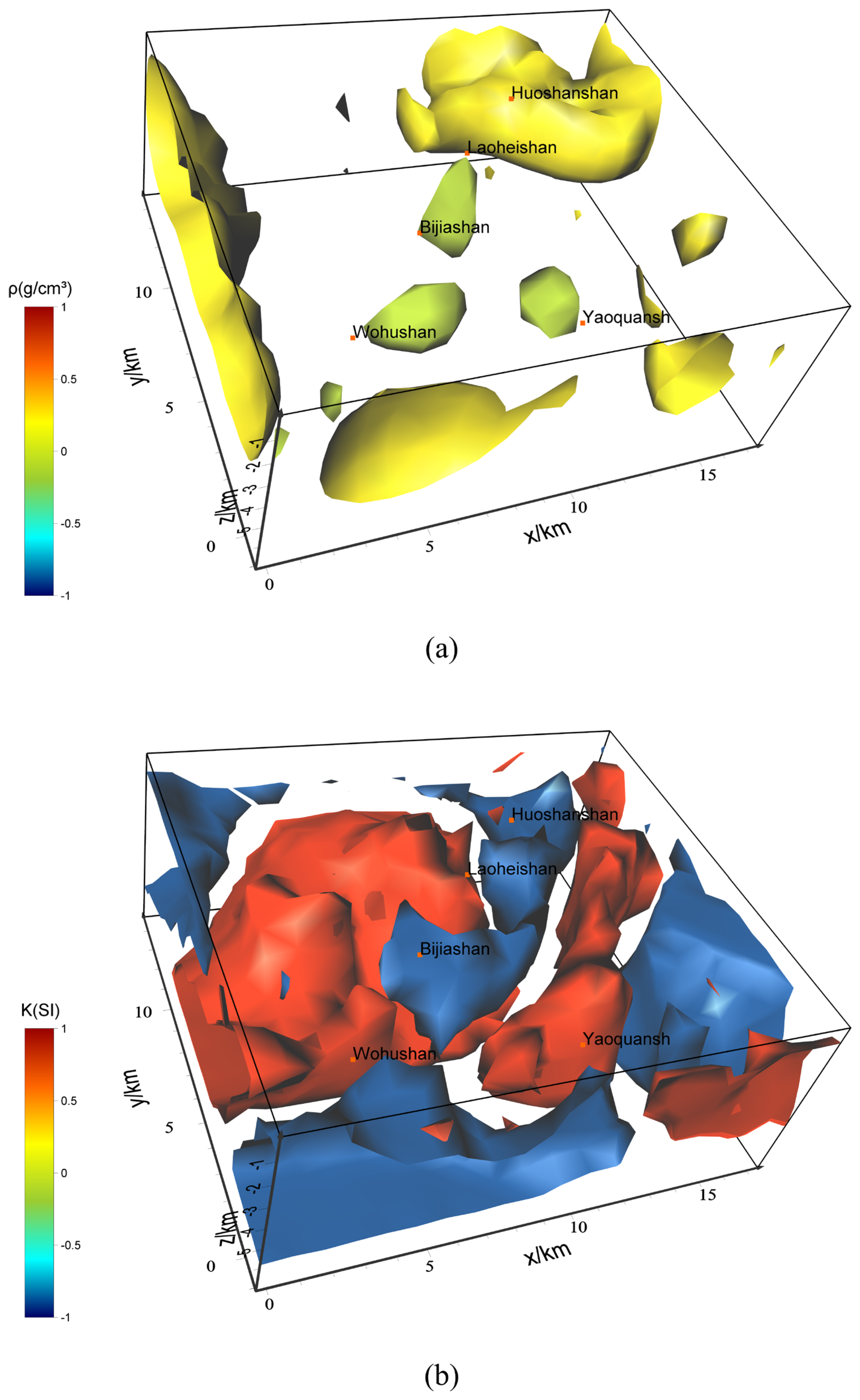
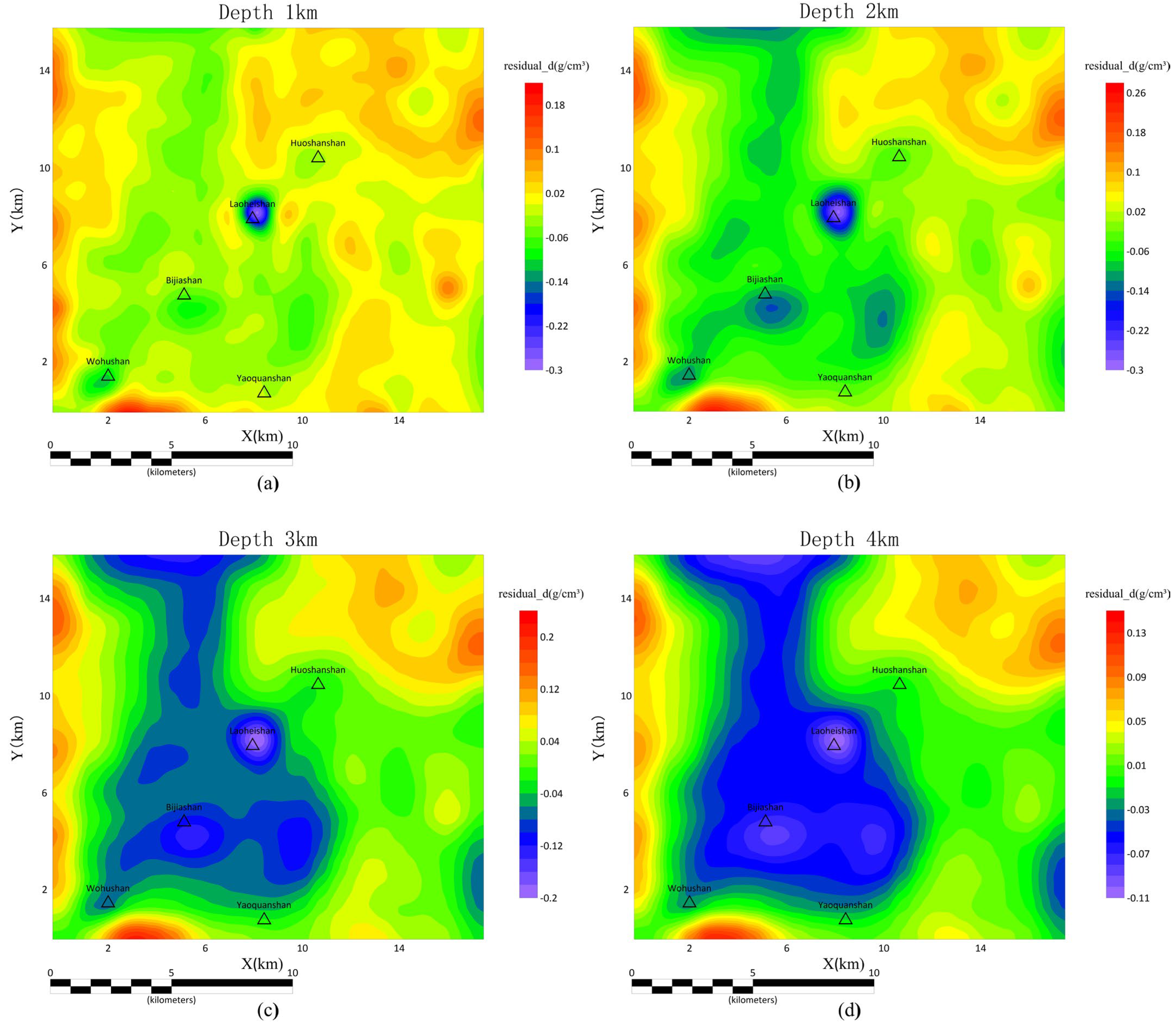
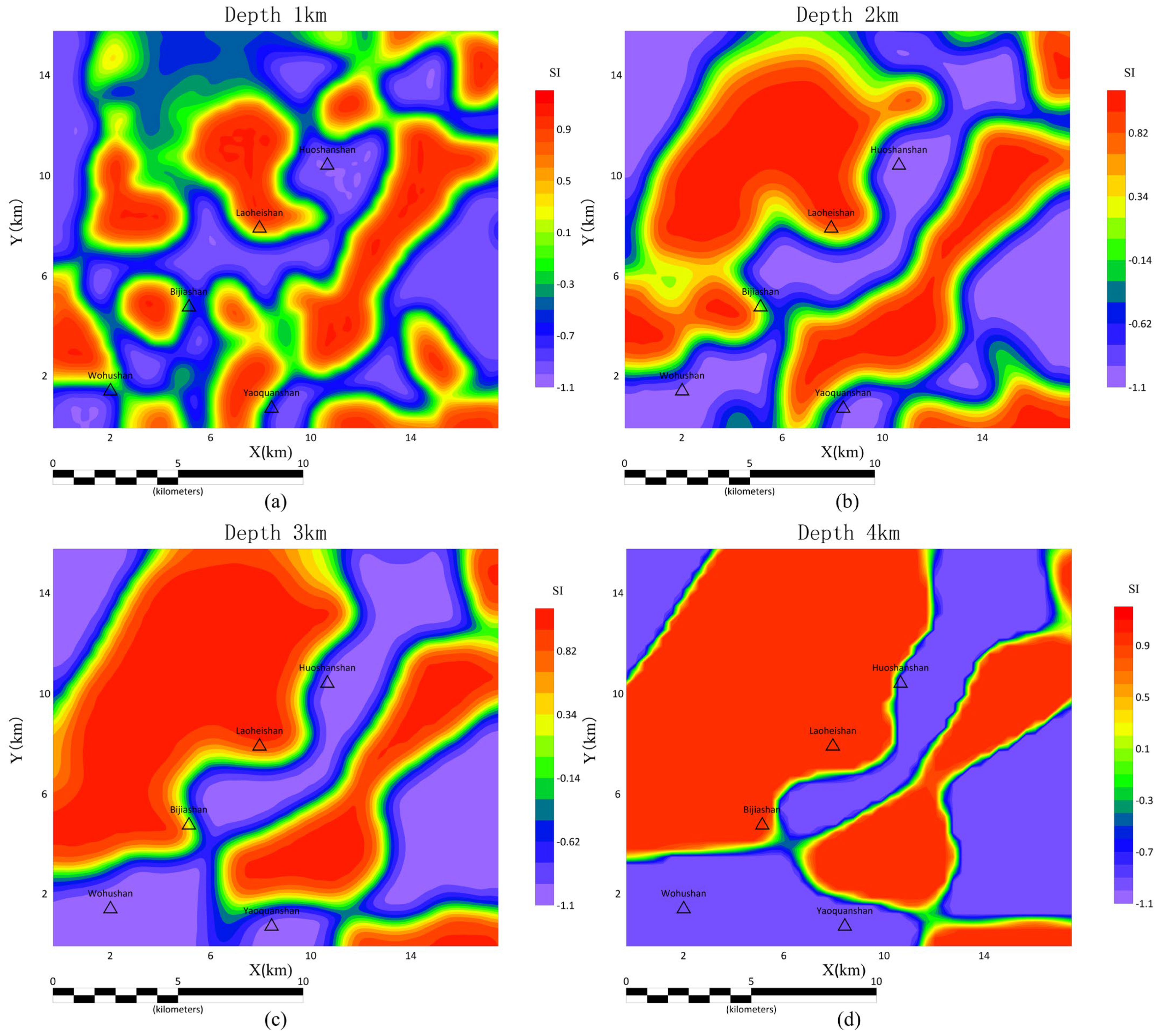
4.2. Analysis of Inversion Results from Gravity and Magnetic Data

Based on the residual Bouguer gravity anomaly data and the residual magnetic anomaly data after magnetic pole reversal, this study performed a cross-gradient-based joint inversion in three-dimensional space. The resulting three-dimensional images are shown in Figure 3a as the residual density model and Figure 3b as the residual magnetization model. Figure 4 presents the horizontal slices of the three-dimensional gravity inversion results at depths of 1 km, 2 km, 3 km, and 4 km, while Figure 5 shows the horizontal slices of the three-dimensional magnetic inversion results at the same depths.
From the gravity inversion results in Figure 3a and Figure 4, it can be observed that the volcanic underground in the study area corresponds to certain low-density rocks. Notably, the underground of the Laoheishan and Bijiashan volcanoes exhibits highly prominent low-density bodies. Additionally, a separate low-density rock body is observed in the northeastern direction of Yaoquanshan at a depth of 2–3 km, detached from nearby volcanoes. The central depth of these low-density rock bodies is approximately 2 to 3 km, with the largest low-density bodies located beneath the Laoheishan and Bijiashan, where the burial depth ranges from about 1 km to 4 km. From the residual density horizontal slice map (Figure 4), it can be observed that at depths of 1 km and 2 km, the low-density bodies beneath each volcano still exist in isolation. However, at depths of 3 km and 4 km, the slice maps show a large low-density region that starts from the Wohushan and Yaoquanshan, extending northward, passing through Laoheishan and Bijiashan, and continuing to the boundary of the study area. At a certain depth, the isolated low-density body located 2–3 km to the northeast of Bijiashan merges with the low-density bodies beneath Bijiashan and Laoheishan, forming a unified structure. This structure approximately coincides with an NE-trending fault and an SE-trending fault that cross the region. The deep magma in the Wudalianchi area moves upwards along the grid-like fractures underground, and these fractures connect the volcanoes in the Wudalianchi region [32]. Therefore, it can be inferred that this isolated low-density body is formed due to the complex intersection of underground fractures between multiple volcanoes. During the magma migration process, it repeatedly intrudes into this area, resulting in the formation of this low-density body. The low-density bodies beneath Laoheishan and Bijiashan exhibit a significant density contrast with the surrounding rocks. Furthermore, based on their locations and shapes, these bodies align with the characteristics of magma chambers. If we assume that these bodies are magma chambers, then their low-density characteristics may also partly arise from the numerous fractures formed after volcanic eruptions. These fractures would contribute to a reduction in the overall density of the rock, further enhancing the low-density signature observed in the data. As the depth increases, these bodies gradually form a unified whole, suggesting that there is a possibility of connectivity between them at depth. Based on geological data from the Wudalianchi region, it is highly likely that these low-density bodies are formed by the intrusion of basalt during volcanic eruptions.
From the magnetic inversion results in Figure 3b and Figure 5, it can be observed that there is no clear, unified correspondence between the low magnetic and high magnetic materials and each volcano in the study area. Instead, rocks with different magnetic susceptibilities are interspersed, and there is a large-scale high-magnetic basement. Beneath Laoheishan and Bijiashan, there are rocks with high magnetic susceptibility, while beneath Wohushan and Huoshaoshan, the rocks have low magnetic susceptibility. Overall, the distribution of magnetic susceptibility rocks forms a boundary line between high magnetic susceptibility rocks and low magnetic susceptibility rocks, stretching from Wohushan to Laoheishan and Huoshaoshan. This boundary line becomes more distinct with increasing depth and aligns with the NE-trending deep faults that control the volcanic activities of Wohushan, Laoheshan, and Huoshaoshan, corresponding to the understanding that the deep faults of Wudalianchi control volcanic activity in the region. Combining the gravity inversion results, the low-density bodies beneath Laoheishan and Bijiashan also exhibit high magnetic susceptibility characteristics. In the residual magnetic susceptibility horizontal slice map (Figure 5), as the depth increases, high magnetic susceptibility bodies start to connect at the same location where the low-density bodies under the Laoheishan, Bijiashan, and Yaoquanshan are located in Figure 4. This suggests that the region as a whole has similar density and magnetic susceptibility characteristics, making it highly likely that the rock bodies are interconnected and form a unified structure. These rock bodies exhibit characteristics of basaltic ore bodies with remanent magnetism formed by magmatic activity, and the magnetic basement of the study area is also composed of these rock bodies. Whether magma remnants or hot dry rocks, they both possess high-temperature characteristics. High temperatures can affect the magnetism of the rocks, and when reaching the Curie temperature, they can lose their magnetism entirely. However, there is no significant difference in density and magnetic susceptibility between the rock bodies beneath Laoheishan and those beneath Bijiashan. Therefore, it can be preliminarily inferred that the rock body beneath Laoheishan, with high magnetic susceptibility and low-density characteristics, is more likely to be a solidified magma chamber, with a lower likelihood of being residual magma or a geothermal reservoir.
From the overall inversion results, the gravity inversion results effectively reflect the spatial extent and location characteristics of the low-density rock bodies beneath the volcano, while the magnetic results clearly show the distribution of highly magnetic rock bodies underground. The correspondence between low-density rock bodies and highly magnetic rock bodies is not consistent across the entire survey area, but they largely coincide around Laoheishan and Bijiashan, indicating they represent the same rock body. From the perspective of rock properties, basalt formed beneath the volcano exhibits stronger magnetism than ordinary rocks due to its iron and magnesium content, and it also carries thermoremanent magnetism from its igneous formation. Therefore, the high magnetic characteristics observed in the survey area are consistent with the inversion results and previous analysis, as the underground is rich in basalt. According to well-logging information from the survey area, a 2000 m-deep borehole reveals basalt only in the shallow 70 m, with the rest being granite, indicating that the basement rocks of Wudalianchi are composed of granite. Basalt is denser than granite, but the inversion results indicate low-density characteristics beneath several volcanoes. This suggests the presence of materials or structures—such as fractures or voids—that reduce density. Based on typical subsurface volcanic structures, it is inferred that the basalt rock bodies contain pores formed by magma channels during volcanic eruptions. However, the current gravity-magnetic inversion results alone are insufficient to draw definitive conclusions, and more evidence is needed. The following profile interpretation will incorporate seismic inversion results to provide a reliable basis for judgment.

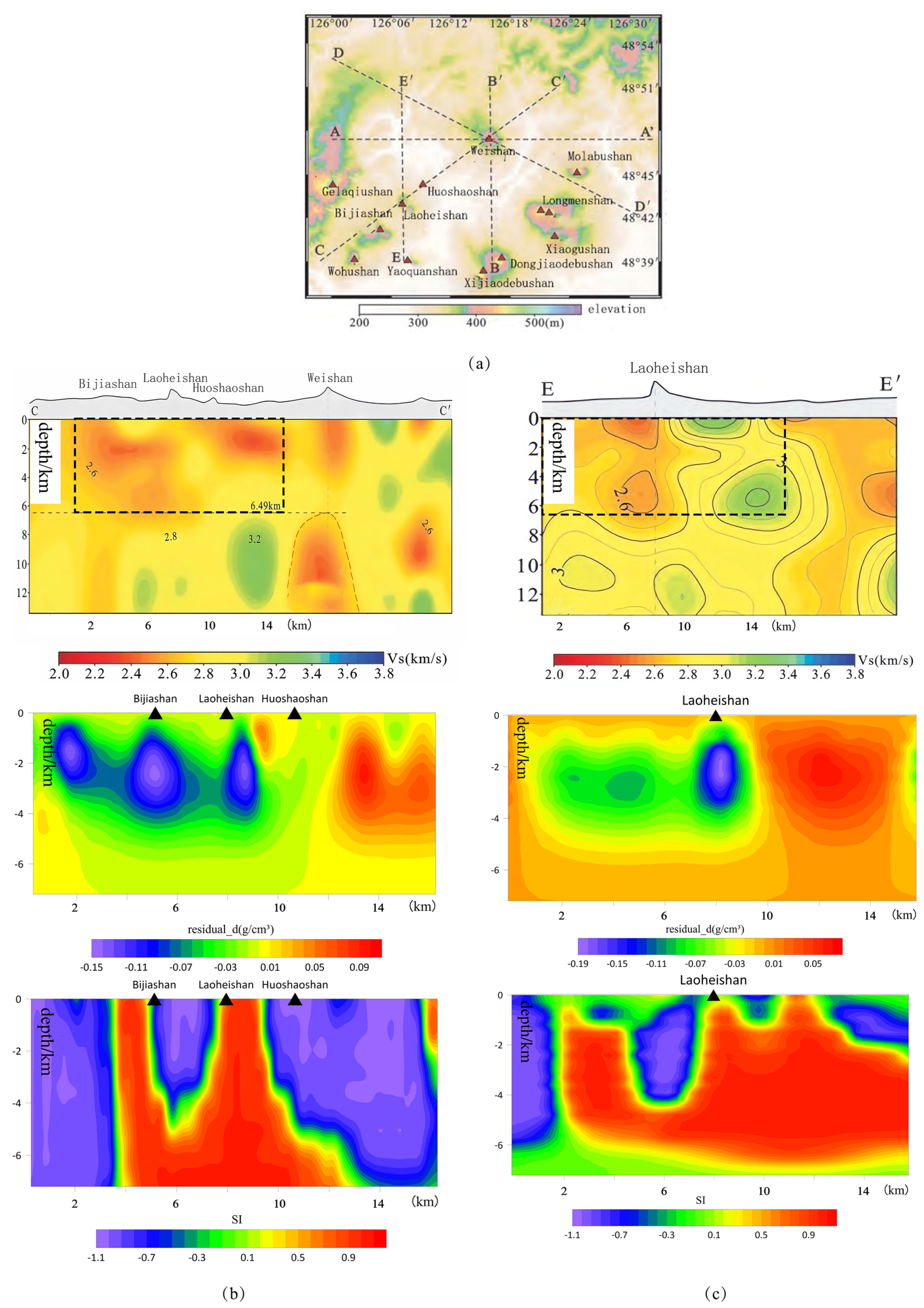
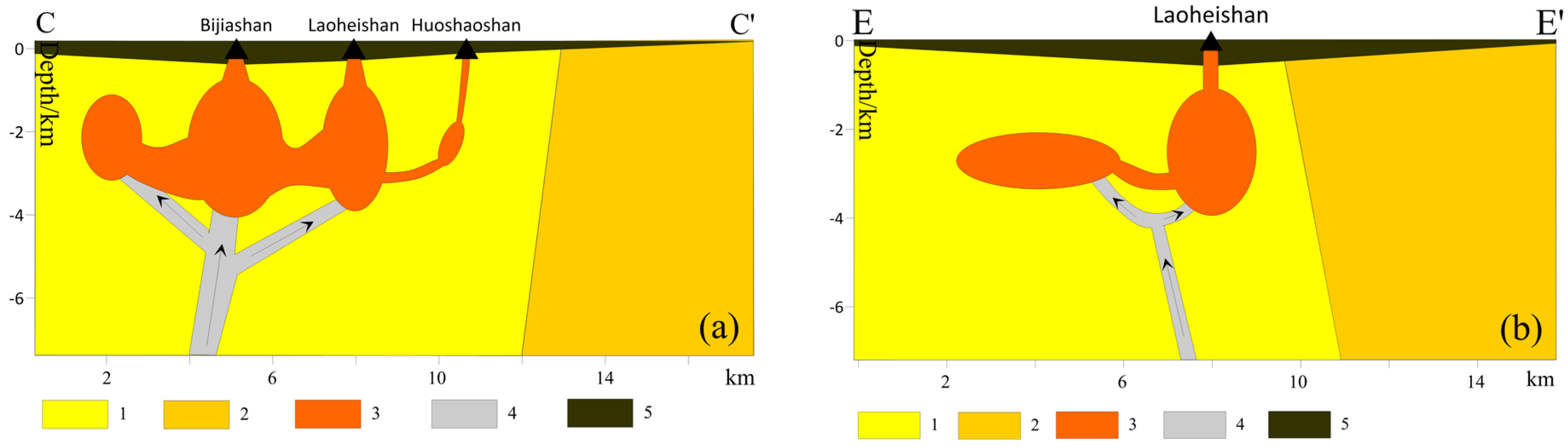
4.3. Joint Interpretation with Seismic Inversion Results

To verify the reliability of the above inference, this paper combines the gravity and magnetic inversion results with the seismic velocity map of the underground structure in the Wudalianchi area, obtained by Zhang et al. [42], for a comprehensive analysis, as shown in Figure 6. From Figure 6, it can be seen that the underground bodies with both high magnetism and low density beneath the Laoheishan and the Bijiashan also exhibit the characteristics of low-velocity bodies. Furthermore, these low-velocity bodies are interconnected, forming a unified structure. This further supports the previous conclusion regarding the interconnection of underground low-density, high-magnetization bodies. Li et al. (2016), in their high-precision seismic imaging of the Wudalianchi area, interpreted the shallow low-velocity bodies beneath the Laoheishan and Huoshaoshan as highly fractured underground rock masses filled with fluids [41]. The seismic wave velocity map and conclusions provide a clear explanation for the earlier observation of low-density inversion results beneath the volcano, despite the presence of high-density basalt. This confirms that the basalt beneath Laoheishan and Bijiashan volcanoes is a mixed rock body containing fractures and fluids. The formation of such a mixed rock body aligns with the characteristics of a cooling magma chamber, ruling out the possibility of residual heat from a magma chamber or the presence of hot dry rock. Figure 6b clearly shows that the low-density rock bodies beneath Laoheishan and Bijiashan are connected through a channel. Additionally, the high magnetic susceptibility rock bodies beneath Bijiashan and Laoheishan converge to form a U-shape at around 5 km depth. Figure 6c further indicates that a similar U-shaped convergence is formed beneath Laoheishan, near the vicinity of Yaoquanshan. According to the view that the high-magnetic rock bodies are formed during volcanic eruptions and consist of basalt carrying remanent magnetization, this U-shaped distribution indicates that the magma channels beneath Bijiashan and Laoheishan converge at a certain depth. This suggests that these two volcanoes may share a common magma source deep underground.
The geological composition of the Wudalianchi area is complex, with the surface primarily consisting of mixed rock layers formed by the superposition of basalt from volcanic eruptions of different ages and layers of mudstone and sandstone [33]. Beneath this mixed rock layer lies the basement, which is composed of granite in the southwestern region and metamorphic rocks in the northeastern region. The density of the metamorphic rock basement is higher than that of the granite basement. The boundary between these two types of basement rocks is roughly located in the central area between Laoheishan and Weishan [42]. Based on previous geological understanding and the inferences made earlier, this paper presents geological maps along the CC′ and EE′ directions, as shown in Figure 7. In the CC′ direction, the granite basement and the metamorphic rock basement are roughly divided by the area of intense density variation north of Huoshaoshan, while in the EE′ direction, the boundary is roughly marked by the area of intense density variation north of Laoheishan. The location of the basalt formed by underground magmatic activity is roughly shown in Figure 7. Regarding the formation process of magma chambers and basalts in the study area, this paper hypothesizes that as magma rises from deep within the Earth’s crust, it accumulates at a certain depth to form a magma chamber. From there, it continually intrudes into the surrounding rock bodies, forming basalt. When the accumulation reaches a certain level, it eventually fractures the crust, causing volcanic eruptions to release magma. The space originally occupied by magma in the magma chamber is also released, gradually evolving into the cracks filling the basalt rock mass, and these cracks are slowly filled with fluid from the surrounding strata. Regarding Laoheishan and Huoshaoshan, their eruption times and locations are quite close. The surface lava distribution indicates that the eruption of Laoheishan was much larger than that of Huoshaoshan. Additionally, the gravity and magnetic inversion results in this paper also demonstrate that the magma activity traces beneath Huoshaoshan are much smaller than those beneath Laoheishan, and there is a connection between the magma chamber beneath Huoshaoshan and beneath Laoheishan. Therefore, it can be inferred that the eruption of Huoshaoshan was driven by the magma chamber of Laoheishan. The magma conduits leading from the volcanic magma chambers to deeper levels in the study area are hypothesized in Figure 7, which provides a model that is more consistent with the gravity, magnetic, and seismic results. In summary, the rock masses beneath the areas of Laoheishan and Bijiashan volcanoes do not exhibit the characteristics of magma residuals or hot dry rock. These rock masses are more likely to have formed from the cooling and solidification of magma chambers. Additionally, according to geothermal data from the local meteorological bureau, the heat flow data in Wudalianchi has remained stable without significant fluctuations in recent years, indicating no obvious signs of shallow geothermal activity in the area. In the future, when searching for geothermal resources in the Wudalianchi area, attention should be focused on deeper strata, while also considering magma conduits that may still be connected to and active with deeper magma systems.

5. Conclusions

This paper is the first to conduct gravity-magnetic joint inversion based on measured gravity and magnetic data in the Laoheishan volcanic area of Wudalianchi, filling the gap in gravity and magnetic inversion results for the shallow subsurface in this region. By integrating previous research findings, a comprehensive analysis and interpretation of the subsurface geological conditions are provided, leading to the following inferences. It is hoped that this study will offer supplementary geophysical insights and evidence for research on the geothermal system of Wudalianchi.
(1) Based on the characteristics of magnetic susceptibility, density, and seismic wave velocity, the underground rock bodies at Laoheishan, Bijiashan, and 2 km to the northeast of Yaoquanshan simultaneously exhibit low density, high magnetic susceptibility, and low wave velocity. It is inferred that these rock bodies are basaltic bodies formed by magmatic activity, carrying remanent magnetism. These rock bodies also contain numerous fractures filled with fluid and are interconnected at greater depths.
(2) The locations of these rock bodies align with the NE-trending and SE-trending faults in the region, confirming that the deep magma in the Wudalianchi area migrates along the grid-like network of faults underground. These faults control the volcanic activity in the Wudalianchi area.
(3) Based on a comprehensive analysis of the inversion results, the special rock mass beneath the Laoheishan volcanic area exhibits physical property characteristics consistent with a cooling magma chamber, making it highly likely to be a solidified and cooling magma chamber. The possibility of residual magma heat and hot dry rock is low in this area. Therefore, the potential for shallow geothermal resources is relatively low. Future exploration and development should focus on deeper thermal reservoirs.

Author Contributions

Conceptualization, Y.G. and Y.W.; methodology, Y.G. and X.L.; software, Y.G.; validation, C.W., Y.G. and M.S.; formal analysis, Y.G.; investigation, M.S. and Y.W.; resources, M.S. and X.L.; data curation, Y.G. and X.L.; writing—original draft preparation, C.W.; writing—review and editing, C.W. and Y.G.; visualization, C.W.; supervision, C.W.; project administration, Y.G.; funding acquisition, Y.G. All authors have read and agreed to the published version of the manuscript.

Funding

This research was funded by the National Key Research and Development Program of China (2022YFF0503100).

Data Availability Statement

Due to property rights, data will be provided upon reasonable request to the corresponding author.

Conflicts of Interest

Author Xiaolong Li was employed by the company Jilin Co., Ltd. of China National Building Materials Resources and Environmental Engineering. The remaining authors declare that the research was conducted in the absence of any commercial or financial relationships that could be construed as a potential conflict of interest.

References

  1. Li, D.; Guo, M. Current Situation and Future Development Trend of Geothermal Resources in China. Chem. Energy 2021, 47, 149–150. [Google Scholar]
  2. Xu, T.-f.; Hu, Z.-x.; Li, S.-t.; Jiang, Z.-j.; Hou, Z.-y.; Li, F.-y.; Liang, X.; Feng, B. Enhanced geothermal system: International progresses and research status of China. Acta Geol. Sin. 2018, 92, 1936–1947. [Google Scholar]
  3. Xu, T.-f.; Wen, D.-g.; Yuan, Y.-l. Technical Challenges and Strategy of Geothermal Energy Development from Hot Dry Rock. Earth Sci. 2024, 49, 2131–2147, (In Chinese with English Abstract). [Google Scholar]
  4. Guiling, W.; Yanguang, L.; Xi, Z.; Wei, Z. The status and development trend of geothermal resources in China. Earth Sci. Front. 2020, 27, 1, (In Chinese with English Abstract). [Google Scholar]
  5. Tang, X.; Wang, G.; Ma, Y.; Zhang, D.; Liu, Z.; Zhao, X.; Cheng, T. Geological model of heat source and accumulation for geothermal anomalies in the Gonghe basin, northeastern Tibetan Plateau. Acta Geol. Sin. 2020, 94, 2052–2065. [Google Scholar]
  6. Lin, W.; Chen, X.; Gan, H.; Yue, G. Geothermal, geological characteristics and exploration direction of hot dry rocks in the Xiamen bay-Zhangzhou basin, southeastern China. Acta Geol. Sin. 2020, 94, 2066–2077. [Google Scholar]
  7. Sun, M.-H.; Zhang, Q.-Z.; Li, D.-M.; Sun, X.-T.; Lin, S.; Wu, X.-K.; Liang, G.-K.; Li, Y.-K.; Guan, Y.-W.; Li, Y.-F. Genesis and occurrence models of hot-dry geothermal resources in Guangxi. Bull. Geol. Sci. Technol. 2022, 41, 330–340, (In Chinese with English Abstract). [Google Scholar] [CrossRef]
  8. Zhang, L.; Li, X.; Zhu, G. Geothermal geological characteristics and genetic model of Hot Dry Rocks in Gonghe Basin, Qinghai Province. Geol. China 2024, 52, 1–17. [Google Scholar]
  9. Wenjing, L.; Hongping, X.; Song, R.; Yizuo, S.; Qiaoran, Z.; Shunde, H.; Guangming, H. Three-dimensional geothermal geological modeling and geothermal target selection in the central depression and adjacent areas of the Songliao Basin. Chin. J. Geol. 2024, 59, 235–248. [Google Scholar]
  10. Wang, L.; Ma, X.-w.; Yu, C.-l.; Han, X.-z.; Tian, Y.-l. Understanding and Preliminary Planning for Layer-Controlled Geothermal Resources in Deep Sag of Songliao Basin. Sino-Glob. Energy 2024, 29, 26–33, (In Chinese with English Abstract). [Google Scholar]
  11. Nouraliee, J.; Porkhial, S.; Mohammadzadeh-Moghaddam, M.; Mirzaei, S.; Ebrahimi, D.; Rahmani, M.R. Investigation of density contrasts and geologic structures of hot springs in the Markazi Province of Iran using the gravity method. Russ. Geol. Geophys. 2015, 56, 1791–1800. [Google Scholar] [CrossRef]
  12. Mohammadzadeh Moghaddam, M.; Mirzaei, S.; Nouraliee, J.; Porkhial, S. Integrated magnetic and gravity surveys for geothermal exploration in Central Iran. Arab. J. Geosci. 2016, 9, 506. [Google Scholar] [CrossRef]
  13. Xi, Y.; Wang, G.; Liu, S.; Zhao, Y.; Hu, X. The formation of a geothermal anomaly and extensional structures in Guangdong, China: Evidence from gravity analyses. Geothermics 2018, 72, 225–231. [Google Scholar] [CrossRef]
  14. Lewerissa, R.; Sismanto, S.; Setiawan, A.; Pramumijoyo, S.; Lapono, L. Integration of gravity and magnetic inversion for geothermal system evaluation in Suli and Tulehu, Ambon, eastern Indonesia. Arab. J. Geosci. 2020, 13, 726. [Google Scholar] [CrossRef]
  15. Pocasangre, C.; Fujimitsu, Y.; Nishijima, J. Interpretation of gravity data to delineate the geothermal reservoir extent and assess the geothermal resource from low-temperature fluids in the Municipality of Isa, Southern Kyushu, Japan. Geothermics 2020, 83, 101735. [Google Scholar] [CrossRef]
  16. Zhao, J.; Zeng, Z.; Zhou, S.; Yan, J.; An, B. 3-D Inversion of Gravity Data of the Central and Eastern Gonghe Basin for Geothermal Exploration. Energies 2023, 16, 2277. [Google Scholar] [CrossRef]
  17. Benfield, A. Terrestrial heat flow in Great Britain. Proc. R. Soc. London Ser. A Math. Phys. Sci. 1939, 173, 428–450. [Google Scholar]
  18. Bullard, E.C. Heat flow in south Africa. Proc. R. Soc. London Ser. A Math. Phys. Sci. 1939, 173, 474–502. [Google Scholar]
  19. Davies, J.H. Global map of solid Earth surface heat flow. Geochem. Geophys. Geosystems 2013, 14, 4608–4622. [Google Scholar] [CrossRef]
  20. Fournier, R.O. Estimation of underground temperatures from the silica content of water from hot springs and wet-steam wells. Amer. J. Sci. 1966, 264, 685–697. [Google Scholar] [CrossRef]
  21. Giggenbach, W.F. Geothermal solute equilibria. Derivation of Na-K-Mg-Ca Geoindicators. Geochim. Cosmochim. Acta 1988, 52, 2749–2765. [Google Scholar] [CrossRef]
  22. Wu, M. A Comparative Study of Sedimentary Geothermal Water and Volcanic Geothermal Water with Hydrogeochemistry Method—Take Guanzhong Basin and Tengchong Rehai as Examples. Master’s Thesis, Chang’an University, Xi’an, China, 2018. [Google Scholar]
  23. Zhou, B.; Pan, B.; Yan, L.; Xu, D.; Wu, C. Analysis to the pressure condition of magmatic system from the Late Pleistocene Changbaishan-Tianchi volcanism. Acta Petrol. Sin. 2024, 40, 2075–2086. [Google Scholar] [CrossRef]
  24. Sheng, S.-z.; Wan, Y.-g.; Jiang, C.-s.; Wang, X.-s.; Liang, S.-s.; Xiao, G.-r.; Hu, X.-h. Study on the crustal stress field of the Tengchong volcanic area using composite focal mechanism method. Appl. Geophys. 2021, 18, 239–252. [Google Scholar] [CrossRef]
  25. Fan, Q.-c.; Sui, J.-l.; Wang, T.-h.; Li, N.; Sun, Q. History of volcanic activity, magma evolution and eruptive mechanisms of the Changbai volcanic province. Geol. J. China Univ. 2007, 13, 175. [Google Scholar]
  26. Li, J.; Ye, T.; Zhang, H.; Huang, Q. A multi-geophysical parameter model in Tengchong volcanic area. Chin. J. Geophys. 2021, 64, 3657–3668. [Google Scholar]
  27. Zhang, J.; Fan, Y.-x.; Chu, W.; He, Y.-b. Changbaishan Tianchi volcano geothermal system: Magma chamber and hidden high-temperature geothermal resources. Acta Seismol. Sin. 2024, 46, 557–577. [Google Scholar]
  28. Lv, Z. Volcanic structure of the present-day volcanic group Wudalianchi and its forming mechanism. Volcanol. Miner. Resour. 1994, 15, 6–21, (In Chinese with English Abstract). [Google Scholar]
  29. Chang, C. Application of Gravity Data Comprehensive Processing Methods in Wudalianchi Area. Master’s Thesis, Jilin University, Changchun, China, 2015. (In Chinese with English Abstract). [Google Scholar]
  30. Li, W.; Yang, M.; Feng, W.; Zhong, M. Improved Approaches for 3D Gravity and Gradient Imaging Based on Potential Field Separation: Application to the Magma Chamber in Wudalianchi Volcanic Field, Northeastern China. Remote Sens. 2024, 16, 1187. [Google Scholar] [CrossRef]
  31. Xiang, M.; Li, J.-h.; Gao, W.-y.; Zhang, T.-r. Vent Distribution of Wudalianchi Volcanoes Heilongjiang Province, China, and Its Relation to Faults. Geol. J. China Univ. 2010, 16, 226. [Google Scholar]
  32. Zeng, P.-S.; Qiu, S.-F.; Li, R.-Z.; Liu, S.-W.; Wang, S.-A.; Zhao, J.-J. Sequences Division of Quaternary Volcanic Rocks in Wudalianchi and Its Tectonic and Ecological Significances. Acta Geosci. Sin. 2021, 42, 785–802, (In Chinese with English Abstract). [Google Scholar]
  33. Wang, J.-y.; Liu, Y.-s.; Pan, M.-H.; Nie, B.-f.; Zou, W.; Lu, Z.; Zhang, X.-y. Topography and Fractal Characteristics and Their Genesis of the Wudalianchi Volcanic Group in Heilongjiang. Geoscience 2024, 38, 793–806, (In Chinese with English Abstract). [Google Scholar] [CrossRef]
  34. Xiao, L.; Wang, C. Geologic features of Wudalianchi volcanic field, northeastern China: Implications for Martian volcanology. Planet. Space Sci. 2009, 57, 685–698. [Google Scholar] [CrossRef]
  35. Zhan, Y.; Zhao, G.; Bai, D.; Jin, G.; Wang, J.; Xuan, F.; Jiang, Z. Preliminary study of Wudalianchi volcanic cluster in Heilongjiang province by MT measurement. Geol. Rev. 1999, 45, 400–408. [Google Scholar]
  36. Zhan, Y.; Zhao, G.; Wang, J.; Xiao, Q.; Tang, J.; Rokityansky, I. Crustal electric conductivity structure for Wudalianchi volcanic cluster in the Heilongjiang province, China. Acta Petrol. Sin. 2006, 22, 1494–1502. [Google Scholar]
  37. Zhao, Y.; Zou, W.-D.; Zhou, H. The Analysis of Wudalianchi Volcanoes Hazard. J. Nat. Disasters 1999, 8, 139–146, (In Chinese with English Abstract). [Google Scholar]
  38. Gao, L.; Zhang, S.-g.; Yan, F. A research of coda in Wudalianchi volcanic area. Seismol. Geomagn. Obs. Res. 2013, 34, 41–46, (In Chinese with English Abstract). [Google Scholar]
  39. Gao, L.; Yang, X. Analysis of Q value character of seismic body wave in Wudalianchi volcanic area. Seismol. Geomagn. Obs. Res. 2018, 39, 23–29. [Google Scholar]
  40. Zhang, B.L.; Li, Z.W.; Bao, F.; Deng, Y.; You, Q.Y.; Zhang, S.Q. Shallow shear-wave velocity structures under the Weishan volcanic cone in Wudalianchi volcano field by microtremor survey. Chin. J. Geophys. 2016, 59, 3662–3673. [Google Scholar]
  41. Li, Z.; Ni, S.; Zhang, B.; Bao, F.; Zhang, S.; Deng, Y.; Yuen, D.A. Shallow magma chamber under the Wudalianchi Volcanic Field unveiled by seismic imaging with dense array. Geophys. Res. Lett. 2016, 43, 4954–4961. [Google Scholar] [CrossRef]
  42. Zhang, S.; Jia, X.; Zhang, Y.; Li, S.; Li, Z.; Tian, P.; Ming, Y.; Zhang, C. Volcanic magma chamber survey and geothermal geological condition analysis for hot dry rock in the Weishan volcano in Wudalianchi region, Heilongjiang Province. Acta Geol. Sin. 2017, 91, 1506–1521. [Google Scholar]
  43. Peng, N. Dynamical stability of magma chamber under the modern volcanoes in the Wudalianchi Area. Master’s Thesis, Capital Normal University, Beijing, China, 2004. [Google Scholar]
  44. Peng, N.; Liu, Y.-s.; Wei, Y.-f. The stability of the magma chamber under Wudalianchi modern volcanoes. Acta Petrol. Mineral. 2005, 24, 197–204. [Google Scholar]
  45. Lu, S.C. Wudalianchi geothermal research. J. Heilongjiang Inst. Sci. Technol. 2013, 23, 386–389, 393, (In Chinese with English Abstract). [Google Scholar] [CrossRef]
  46. Lu, S.C. Wudalianchi geothermal research. Adv. Mater. Res. 2013, 805, 445–451. [Google Scholar] [CrossRef]
  47. Portniaguine, O.; Zhdanov, M.S. 3-D magnetic inversion with data compression and image focusing. Geophysics 2002, 67, 1532–1541. [Google Scholar] [CrossRef]
  48. Li, Y.; Oldenburg, D.W. Fast inversion of large-scale magnetic data using wavelet transforms and a logarithmic barrier method. Geophys. J. Int. 2003, 152, 251–265. [Google Scholar] [CrossRef]
  49. Davis, K.; Li, Y. Fast solution of geophysical inversion using adaptive mesh, space-filling curves and wavelet compression. Geophys. J. Int. 2011, 185, 157–166. [Google Scholar] [CrossRef]
  50. Meagher, D. Geometric modeling using octree encoding. Comput. Graph. Image Process. 1982, 19, 129–147. [Google Scholar] [CrossRef]
  51. Yerry, M.; Shephard, M. A modified quadtree approach to finite element mesh generation. IEEE Comput. Graph. Appl. 1983, 3, 39–46. [Google Scholar] [CrossRef]
  52. Gross, L. Weighted cross-gradient function for joint inversion with the application to regional 3-D gravity and magnetic anomalies. Geophys. J. Int. 2019, 217, 2035–2046. [Google Scholar] [CrossRef]
  53. Zhang, R.; Li, T.; Deng, H.; Deng, X.; Shi, H.; Wang, S.; Pak, Y. 2D joint inversion of MT, gravity, magnetic and seismic first-arrival wave traveltime with cross-gradient constraints. Chin. J. Geophys. 2019, 62, 2139–2149. [Google Scholar]
  54. Vatankhah, S.; Liu, S.; Renaut, R.A.; Hu, X.; Hogue, J.D.; Gharloghi, M. An Efficient Alternating Algorithm for the Lp-Norm Cross-Gradient Joint Inversion of Gravity and Magnetic Data Using the 2-D Fast Fourier Transform. IEEE Trans. Geosci. Remote Sens. 2020, 60, 1–16. [Google Scholar] [CrossRef]
  55. Fregoso, E.; Palafox, A.; Moreles, M.A. Initializing cross-gradients joint inversion of gravity and magnetic data with a Bayesian surrogate gravity model. Pure Appl. Geophys. 2020, 177, 1029–1041. [Google Scholar] [CrossRef]
  56. Zhengwen, Y.; Handong, T.; Miao, P.; WenXin, K.; PingPing, W. Three-dimensional joint inversion of gravity, magnetic and magnetotelluric data based on cross-gradient theory. Chin. J. Geophys. 2020, 63, 736–752. [Google Scholar]
  57. Bosch, M.; Meza, R.; Jiménez, R.; Hönig, A. Joint gravity and magnetic inversion in 3D using Monte Carlo methods. Geophysics 2006, 71, G153–G156. [Google Scholar] [CrossRef]
  58. Fregoso, E.; Gallardo, L.A. Cross-gradients joint 3D inversion with applications to gravity and magnetic data. Geophysics 2009, 74, L31–L42. [Google Scholar] [CrossRef]
  59. Tikhonov, A.N.; Arsenin, V.Y. Solutions of Ill-Posed Problems; Winston: New York, NY, USA, 1977. [Google Scholar]
  60. Willoughby, R.A. Solutions of ill-posed problems (A.N. Tikhonov and V.Y. Arsenin). SIAM Rev. 1979, 21, 266. [Google Scholar] [CrossRef]
  61. Golub, G.H.; Hansen, P.C.; O’Leary, D.P. Tikhonov regularization and total least squares. SIAM J. Matrix Anal. Appl. 1999, 21, 185–194. [Google Scholar] [CrossRef]
  62. Li, Y.; Oldenburg, D.W. 3-D inversion of magnetic data. Geophysics 1996, 61, 394–408. [Google Scholar] [CrossRef]
  63. Li, Y.; Oldenburg, D.W. 3-D inversion of gravity data. Geophysics 1998, 63, 109–119. [Google Scholar] [CrossRef]
Figure 1. (a) Wudalianchi geographical location map. (b) Wudalianchi geological map. (modified after Xiao and Wang [34]).
Energies 18 02011 g001
Figure 2. (a) Elevation map of the survey area. (b) Map of the residual gravity anomalies in the survey area. (c) Map of the residual magnetic anomalies after demagnetization in the survey area.
Energies 18 02011 g002
Figure 3. Joint inversion results map. (a) Three-dimensional residual density distribution map. (b) Three-dimensional residual magnetic susceptibility distribution map.
Energies 18 02011 g003
Figure 4. Residual density horizontal slice map: (a) depth 1 km; (b) depth 2 km; (c) depth 3 km; (d) depth 4 km.
Energies 18 02011 g004
Figure 5. Residual magnetic susceptibility horizontal slice map: (a) depth 1 km; (b) depth 2 km; (c) depth 3 km; (d) depth 4 km.
Energies 18 02011 g005
Figure 6. (a) The seismic survey line location map. (b) shows the velocity profile of survey line CC′ along with the gravity inversion results and magnetic inversion results. (c) shows the velocity profile of survey line EE′ along with the gravity inversion results and magnetic inversion results. In the velocity map, the dashed area represents the corresponding range of gravity data inversion and magnetic data inversion. (modified after Zhang [42]).
Energies 18 02011 g006
Figure 7. (a) Geological map along the CC′ direction. (b) Geological map along the EE′ direction. 1, granite; 2, metamorphic rock; 3, basalt; 4, inferred magma conduit; 5, mixed rock layer of basalt and mudstone-sandstone.
Energies 18 02011 g007
Disclaimer/Publisher’s Note: The statements, opinions and data contained in all publications are solely those of the individual author(s) and contributor(s) and not of MDPI and/or the editor(s). MDPI and/or the editor(s) disclaim responsibility for any injury to people or property resulting from any ideas, methods, instructions or products referred to in the content.

