Abstract
Given the high proportion of global fossil energy consumption, the Ordovician karst water in the North China-type coalfield, as a green energy source that harnesses both water and heat, holds significant potential for mitigating environmental issues associated with fossil fuels. In this work, we collected geothermal water samples and conducted borehole temperature measurements at the Xinhu Coal Mine in the Huaibei Coalfield, analyzed the chemical composition of regional geothermal water, elucidated the characteristics of thermal storage, and explored the influence of regional structure on the karst geothermal system in the northern region. The results indicate that the geothermal water chemistry at the Xinhu Coal Mine is of the Na-K-Cl-SO4 type, with its chemical composition primarily controlled by evaporation and concentration processes. The average temperature of the Ordovician limestone thermal reservoir is 48.2 °C, and the average water circulation depth is 1153 m, suggesting karst geothermal water undergoing deep circulation. The geothermal gradient at the Xinhu Coal Mine ranges from 22 to 33 °C/km, which falls within the normal range for ground-temperature gradients. A notable jump in the geothermal gradient at well G1 suggests a strong hydraulic connection between deep strata within the mine. The heat-accumulation model of the hydrothermal mine geothermal system is influenced by strata, lithology, and fault structures. The distribution of high ground-temperature gradients in the northern region is a result of the combined effects of heat conduction from deep strata and convection of geothermal water. The Ordovician limestone and extensional faults provide a geological foundation for the abundant water and efficient heat conduction of the thermal reservoirs.
1. Introduction
Global fossil energy consumption accounted for 79.9% of the total energy expenditure in 2023. This high reliance on fossil fuels has led to resource depletion, environmental pollution, and climate change [1,2,3]. Consequently, the accelerated development of clean and efficient renewable energy sources has emerged as a consensus among numerous nations. Geothermal energy, as a renewable resource unaffected by weather fluctuations, has gained attention as a key element in the transformation of energy consumption due to its abundant reserves, safety, efficiency, and low operational and maintenance costs [4,5]. There are 198 geothermal fields worldwide equipped with geothermal power units, boasting a collective installed capacity of 16,318 MW. In 2023, the United States’ geothermal power generation reached 18,366 million kW·h, securing the top position globally. Nations such as Iceland and Kenya, where geothermal power generation constitutes over 30% of their total electricity production, have significantly integrated it into their energy mix [6]. In June 2022, China’s National Development and Reform Commission released the “14th Five-Year Plan” for renewable energy development, which highlights the active promotion of large-scale geothermal energy deployment, providing strong support for the stable growth and high-quality development of the geothermal industry. Since 2015, China has led the world in the direct utilization of geothermal energy, achieving notable economic, social, and environmental benefits [7]. China’s geothermal resources are generally distributed with higher concentrations in the east and southwest and lower concentrations in the central and northwest regions. Regions with significant utilization of medium- and low-temperature geothermal resources, such as the North China Plain, Subei Basin, Songliao Basin, and Ordos Basin, have been established [8,9,10]. The total volume of hydrothermal geothermal resources in China is estimated at 1.25 trillion tons of standard coal equivalent [11]. Influenced by the geological structure of uplifted mountains and sedimentary basins, Anhui Province stands out as a region rich in geothermal resources, with the application area for geothermal energy in building heating and cooling exceeding 20 million square meters [12,13]. Therefore, the development and application of geothermal energy in China are not only rapidly expanding but are also positioned to become a key component of the nation’s energy mix, making a substantial contribution to the country’s ambitious goal of achieving carbon neutrality.
Within the next 10 to 15 years, more than half of China’s coal resources are expected to be extracted from depths exceeding 1000 m. As mining depths increase, the issue of high-temperature heat damage in mines is becoming increasingly severe. Along with high geostress and high karst water pressure, these factors constitute the typical environmental challenges of deep mining. Recently, several scholars have proposed innovative approaches to the development and utilization of geothermal resources in mines. Wang et al. (2023) [14] evaluated the geothermal reserves in key coal-producing regions of China and highlighted that coal and geothermal co-mining, along with the prevention of thermal hazards, will be the primary focus of geothermal research in coalfields. Zhang et al. (2022) [15] conducted a comprehensive analysis of the development and utilization status of geothermal resources in abandoned mines across the Huainan and Huaibei regions. Employing remote sensing technology alongside ArcGIS software, they carried out an extensive evaluation of the geothermal resources therein. Huang et al. (2024) [16] proposed a new thermal hazard assessment framework, which integrates the CRITIC method with uncertainty measurement theory for deep mining. This framework offers a novel approach to ensuring site safety and promoting the sustainable use of geothermal energy. Zhang et al. (2023) [17] proposed replacing coal resources with phase-change thermal-storage function filling materials to construct a coal thermal-storage development system, thereby realizing the efficient development of mine geothermal energy. Anderson et al. (2019) [18] systematically discussed the development trends of geothermal technology and the potential of utilizing abandoned mines for underground energy storage and geothermal applications, emphasizing the pivotal role of mine geothermal technology in the future.
Hydrothermal geothermal resources, characterized by abundant reserves and relatively low extraction difficulty, serve as the primary source for global geothermal power generation [19]. In a study of heat-accumulation mechanisms, Wang et al. (2020) [20] proposed a genesis theory for China’s geothermal resources, summarized as “homologous symbiosis—crust-mantle heat generation—tectonic heat accumulation”. Through a systematic approach, they analyzed the transport mechanisms, heat source dynamics, and genesis patterns of typical hydrothermal systems. Li et al. (2024) [21] identified a dual tectonic heat-gathering mode within the geothermal system of the Pingdingshan Coalfield. Their findings emphasize the interplay between the thermal conductivity of local rocks and the spatial arrangement of regional tectonics, which together govern the elevated geothermal temperature conditions. Based on the geological structure of the Sichuan Basin and its surrounding areas, Li et al. (2023) [22] proposed three tectonic models for the genesis of hydrothermal geothermal resources: folded, monoclinal, and fold-fracture composite. They suggest that tectonic activity is the primary factor influencing the current distribution patterns of geothermal resources. Barcelona et al. (2019) [23] introduced a conceptual model for the Bañitos-Gollete geothermal system, highlighting the significant impact of the N-S trending fault system on fluid circulation pathways, thus paving the way for future geothermal research in the region. These studies collectively demonstrate that the development and utilization of mine geothermal resources have become a crucial topic within the geothermal field. This is not only a key strategy for addressing the challenges posed by heat damage in deep mining operations but also a vital component in ensuring the sustainable development of mining.
Based on the geothermal geological conditions of the Xinhu Coal Mine in the Huaibei Coalfield, we analyze the chemical composition characteristics and indicative significance of the regional geothermal water, reveal the temperature of the geothermal reservoir and the depth of water circulation, determine the controlling role of regional tectonics on the karst geothermal system in the deep mines, and propose a water-rich and heat-accumulation model of the Xinhu Coal Mine geothermal system. This research can promote the coordinated development of geothermal energy and coal production and optimize the comprehensive utilization of mine geothermal resources. Moreover, it will contribute to carbon emission reduction and the transformation of China’s energy structure.
2. Regional Geological Setting
2.1. Structure and Stratigraphy
The Xinhu Coal Mine is located in the central part of the Guoyang mining area within the Huaibei Coalfield, situated at the southeastern margin of the North China Plate and in the central region of the eastern Yuhuai Depression. The coalfield is bounded by the Tanlu Fault to the east, connecting with the Yangtze Plate, and by the Xiayi-Fuyang Fault to the west, adjacent to the Hehuai Subsidence Zone. The formation and development of the coalfield structures are closely related to the evolution of intra-plate and plate-margin tectonics. The structural framework within the area is primarily controlled by east–west trending structures, northeast-trending structures, and the Xu-Su arcuate structure, with the east–west and northeast-trending structures forming the dominant patterns. Notably, the northeast-trending structures have reworked earlier east–west trending structures. As a result of multiple phases of tectonic activity, the area features a crisscross pattern of major east–west and north–northeast trending faults, creating a near-mesh-like block fault structure (Figure 1).
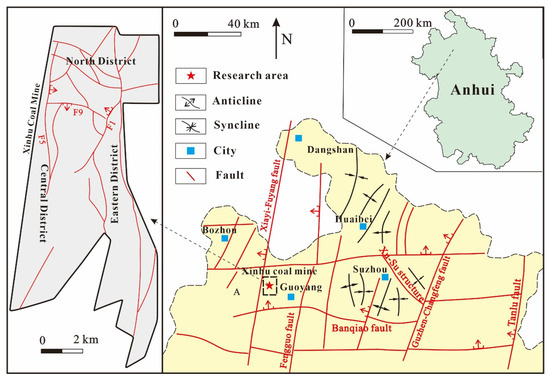
Figure 1.
Geologic structure outline map of Huaibei Coalfield.
The stratigraphic sequence of the Xinhu Coal Mine is consistent with that of the main exploration areas within the Huaibei Coalfield, all of which belong to the North China-type stratigraphic framework. The region exhibits a relatively complete development of strata, except for the absence of the Upper Ordovician-Lower Carboniferous and Triassic strata. While lithological characteristics and thicknesses vary across regions, they are generally comparable. The Carboniferous and Permian strata are identified as coal-bearing formations. From top to bottom, the primary stratigraphic units include the Upper Shihezi Formation, Lower Shihezi Formation, and Shanxi Formation (Figure 2). The Carboniferous contains 4–5 thin coal seams, while the Permian includes 15–30 coal seams, of which 5–10 are mineable. The dominant lithologies consist of mudstone, sandstone, and coal. Additionally, the Middle and Lower Ordovician are characterized by limestone layers of varying thickness.
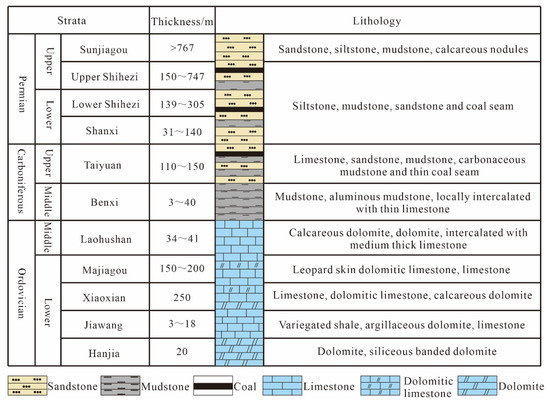
Figure 2.
Comprehensive histogram of stratigraphy in Huaibei Coalfield.
2.2. Hydrogeological Condition
As an integral part of the hydrogeological system of the Huaibei Coalfield, the hydrogeological characteristics of the Xinhu Coal Mine are significantly influenced by the regional tectonic framework. The coalfield is bounded by the Guzhen-Changfeng Fault to the east, the Banqiao Fault to the south (adjacent to the Huainan Coalfield), and the Xiayi-Fuyang Fault and Fengguo Fault to the west (bordering the Taikang Uplift and Zhoukou Depression) (Figure 1). These major fault structures regulate the recharge, runoff, and discharge conditions of the area’s groundwater, resulting in the formation of a predominantly closed to semi-closed, grid-like hydrogeological unit.
Based on the aquifer conditions and the spatial distribution of water-bearing strata, the hydrogeological units in the region can be categorized into three main types: the Quaternary unconsolidated pore aquifers, the Permian sandstone-fissure aquifers within the main coal-bearing layers, and the Taiyuan Formation and Ordovician limestone karst-fissure aquifers. The normal inflow rate of active mines within the Huaibei Coalfield ranges from 100 to 700 m3/h. The direct water sources for mine flooding are the sandstone-fissure aquifers in the roof and floor of coal seams. These aquifers are characterized by limited recharge capacity, relying primarily on static reserves. The volume of water discharged from specific points is closely related to the development of structural fractures and the availability of recharge sources. In the absence of water-rich aquifer recharge, groundwater flow generally exhibits a declining trend over time.
3. Sample and Method
This study collected 12 geothermal water samples from the Xinhu Coal Mine for comprehensive water quality analysis. The samples were obtained from the bedrock mixing layers of wells G1, G2, and G3; the Ordovician limestone layers of wells G4, G7, G8, G11, and G12; the sandstone layers of coal seam roofs and floors from wells G5, G6, and G10; and the fault zone at well G9. Samples were stored in pre-cleaned bottles that had been acid-washed and rinsed with deionized water to prevent external contamination. Sufficient sample volumes were collected at each site to facilitate subsequent analyses of pH, TDS, and major and trace elements.
On-site pH measurements were conducted using a calibrated portable instrument (HQ40D, Hach, Loveland, CO, USA). Samples for major cation and trace element analysis were acidified with ultrapure nitric acid to achieve a pH below 2. The concentrations of major cations, including Na+, K+, Ca2+, and Mg2+, were determined using ICP-OES (ThermoFisher IRIS Intrepid II XSP, Waltham, MA, USA) with an accuracy of within 1%. Trace elements were analyzed using ICP-MS (Agilent 7800, Agilent, Santa Clara, CA, USA). Anion concentrations, including F−, Cl−, NO3−, and SO42−, were quantified via ion chromatography (ICS-1000, Diane, Freehold, NJ, USA) with a precision of within 5%. Additionally, the concentration of SiO2 was measured using spectrophotometry.
4. Geochemistry of Geothermal Water
4.1. Chemical Element Composition of Geothermal Water
Analyzing the chemical characteristics of groundwater provides insights into the geological environment of geothermal water and reveals information about the elemental composition and concentration [24,25]. Typically, the dominant ions in water samples are visually represented using a Piper diagram (Figure 3), which aids in classifying the chemical phases of the water [26]. In this investigation, we procured hydrogeochemical data (Table 1) from twelve mining sites within the Xinhu Coal Mine for comprehensive hydrochemical characterization. The findings reveal that, among the cations, the sum of Na+ and K+ constitutes over 70% of the total cationic content, Mg2+ is less than 10%, and Ca2+ is less than 20%. This suggests that Na+ and K+ are the dominant cations in the geothermal waters of the Xinhu Coal Mine. Regarding the anions, the water sample sites predominantly cluster in the lower right quadrant, indicating a predominance of Cl−, SO42−, and HCO3−. Notably, Cl− is the most abundant anion, representing 50% to 80% of the total anionic content, which suggests that the geothermal waters in this area are predominantly of the Na-K-Cl-SO4 type.
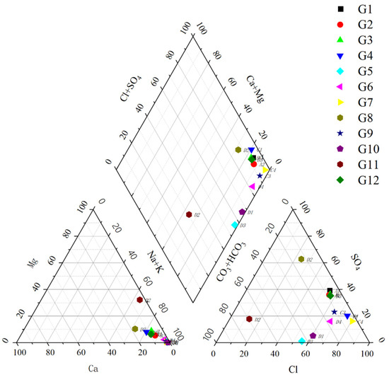
Figure 3.
Geothermal water Piper diagram.

Table 1.
Hydrogeochemical composition of geothermal water samples.
Furthermore, in the field of hydrogeology, the Gibbs diagram (Figure 4) is frequently employed to elucidate the origins and governing factors of groundwater’s chemical constituents. The Gibbs model categorizes the controlling factors of groundwater chemistry into three distinct groups: rainfall-controlled, rock-weathering, and evaporation concentration [27]. The majority of water sample points depicted in the diagram exhibit high TDS and elevated Cl−/(Cl− + HCO3−) ratios, situating them within the evaporative deposition zone. This implies that the chemical composition of the water is predominantly influenced by the concentration of salts due to evaporation processes.
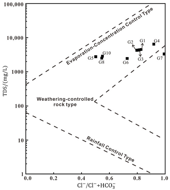
Figure 4.
Gibbs diagram of TDS and Cl−/Cl− + HCO3−.
As an inert tracer, Cl− remains almost unchanged during water–rock interaction. Therefore, studying the interrelationships between Cl− and other solutes effectively reveals the processes of solute change in groundwater. It is one of the key ways to understand the evolution of water chemistry [28]. The mass concentration ratio of HCO3− to Cl− in groundwater is an important indicator for assessing the characteristics of water cycling. An elevated HCO3−/Cl− ratio typically signifies rapid groundwater circulation through shorter flow paths, while a lower ratio indicates slower circulation processes and longer flow paths [29]. Most of the water samples from the Xinhu Coal Mine exhibit a low HCO3−/Cl− ratio and a high Cl− mass concentration (Figure 5a). This indicates that its thermal storage environment is relatively closed, and the geothermal fluid runoff time is long, which should be the karst geothermal water formed by experiencing deep circulation. Water samples also show a high positive correlation between Na+ + K+ and Cl− (Figure 5b), indicating widespread salt rock dissolution in the study area. It is hypothesized that silicate dissolution or cation exchange processes have occurred in the groundwater, positioning some water samples below the y = x line in the plot.
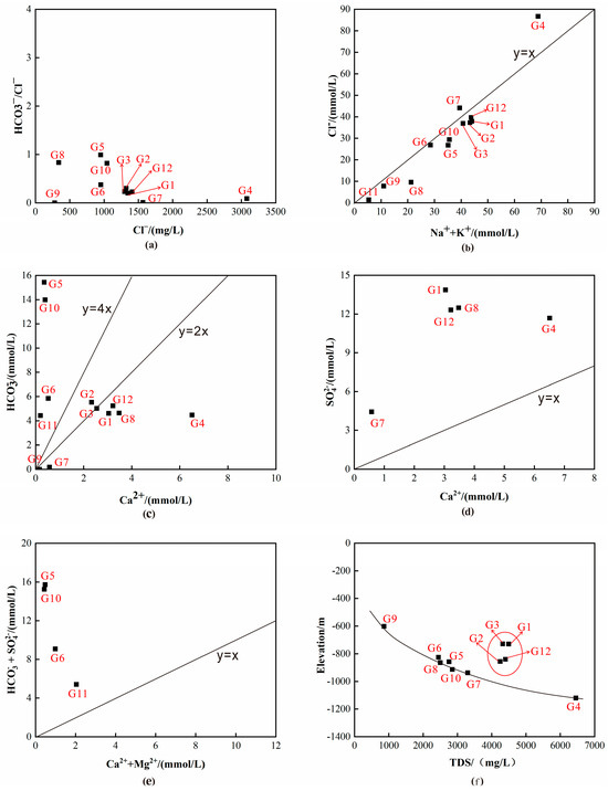
Figure 5.
Proportion of major ions in water samples. (a) The relationship between Cl− and HCO3−/Cl− ratio; (b) The relationship between Na+ + K+ and Cl−; (c) The relationship between Ca2+ and HCO3−; (d) The relationship between Ca2+ and SO42− (e) The relationship between Ca2+ + Mg2+ and HCO3− + SO42−; (f) The relationship between TDS and elevation.
The analysis of ionic ratios in groundwater provides critical insights into water–rock interaction processes. In the relationship between Ca2+ and HCO3− concentrations, sample points G2 and G3 are positioned between the y = 2x and y = 4x lines (Figure 5c), indicating that the dissolution of calcite and dolomite predominantly governs their geochemical characteristics. In contrast, sample points G1, G4, G7, G8, and G12 appear below the y = 2x line with elevated Ca2+ concentrations. When considering the relationship between Ca2+ and SO42− together, these points plot above the y = x line (Figure 5d), suggesting the concurrent dissolution of gypsum (CaSO4·2H2O), with Ca2+ participating in cation exchange processes that enhance SO42− concentrations. Furthermore, sample points G5, G6, G10, and G11 lie above the y = 4x line (Figure 5c). Their corresponding positions also show an under-representation of Ca2+ + Mg2+ relative to HCO3− + SO42− (Figure 5e), suggesting the involvement of additional cations from silicate mineral weathering. These cations likely neutralize anions, thereby influencing the ionic equilibrium of these samples.
The scatter plot depicts the relationship between the TDS concentration of geothermal water and sampling elevation. The data reveal an overall negative correlation, with TDS concentrations increasing as elevation decreases (Figure 5f). Additionally, certain shallow geothermal water samples exhibit anomalously high TDS values. This pattern suggests that geothermal water flows downward along the dip direction, undergoing a series of water–rock interactions with the surrounding strata that progressively elevate TDS concentrations. In deeper zones, hydraulic pressure and thermodynamic forces drive the upward migration of geothermal water, further increasing TDS concentrations and ultimately resulting in elevated TDS levels in some shallow-water samples.
4.2. Geochemical Geothermometer
The SiO2 geothermal temperature scale, a pivotal tool in geothermal exploration and development, is extensively employed to ascertain the temperatures of geothermal wells [30,31]. This scale fundamentally relies on the correlation between the concentration of dissolved silica (SiO2) in water and the temperature, thereby enabling the inference of the fluid’s temperature [32]. In numerous instances, the SiO2 temperature scale exhibits a strong correlation with actual temperatures, offering a reliable estimate of temperature. Common SiO2 geothermometers include the quartz geothermometer without vapor loss, the quartz geothermometer with maximum vapor loss, the chalcedony geothermometer, and the cristobalite geothermometer. By plotting the dissolution curves of various geothermometers in relation to SiO2 (Figure 6), it can be observed that most water sample points fall near the quartz geothermometer without vapor loss and the quartz geothermometer with maximum vapor loss. Therefore, the average value of the results obtained from these two geothermometers is selected as the reservoir temperature in the study area. Their calculation formulas are as follows:
where S is the solubility of SiO2 and T is the thermal storage temperature. Utilizing the comprehensive water-quality analysis results from the limestone section, the SiO2 temperature scale was applied to calculate the average thermal reservoir temperature, yielding T = 51.7 °C. Through incorporation of data from aqueous samples in the sandstone aquifer, the formation temperature was determined to be 46.8 °C. The high geothermal characteristics of this layer suggest the presence of a high-temperature deep-circulation groundwater upwelling process.
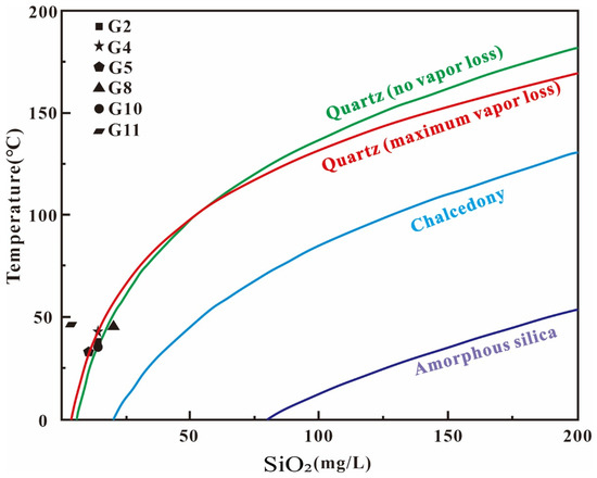
Figure 6.
SiO2 dissolution curve of water samples in the study area.
The temperature of the hot water in geothermal wells is contingent upon the depth of circulation of the geothermal fluids, exhibiting a positive correlation. The formula for this calculation can be articulated as follows:
where Z is the depth of groundwater circulation, m; t is the thermal storage temperature, °C; t0 is the temperature of the thermostatic zone, °C; k is the geothermal gradient, °C/m; and Z0 is the depth of the thermostatic zone, m. Integrating the pertinent data, the temperature of the thermostatic zone at the Xinhu Coal Mine is approximately 17.1 °C, with a depth of approximately 30 m. Analysis of the borehole temperature measurement curves (Figure 7) reveals that the average geothermal gradient of the coal mine is 27.7 °C/km. Based on these calculations, the average depth of geothermal water circulation in the zone is determined to be 1279 m.
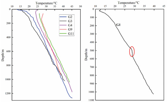
Figure 7.
Typical borehole temperature measurement curve in the Xinhu Coal Mine.
5. Distribution and Genetic Mechanism of the Geothermal Field
5.1. Borehole Temperature Measurement
Borehole temperature-measurement technology is central to the field of geothermal science, offering the most precise method for directly acquiring regional temperature profiles [33,34]. We selected six drilling temperature measurement profiles from the Xinhu Coal Mine, with measurement depths extending from 0 to 1265 m. The geothermal gradients of these six boreholes were corrected to fall within the range of 24 to 32 °C/km, with an average geothermal gradient of 27.7 °C/km. The study area is characterized by a relatively low geothermal gradient.
The temperature measurement curves for G2, G3, G4, G9, and G11 exhibit a linear increase in temperature with depth throughout the borehole section (Figure 7), indicating a stable increase in ground temperature with depth. These curves are indicative of a typical conductive-type curve. In contrast, the temperature measurement curve for G1 displays a significant decrease in geothermal gradient with increasing depth, demonstrating a relatively constant temperature distribution between 500 and 580 m. Notably, the G1 features a high geothermal gradient of 35.9 °C/km at a shallow depth of 500 m, which contrasts with a lower geothermal gradient of 23.5 °C/km in the stratum extending from 580 to 1026 m.
According to Zhang et al. (2014) [35], the cyclical rise of groundwater in the Xinhu Coal Mine is the primary factor responsible for the anomalous ground temperature. The coal reservoir of the Xinhu Coal Mine is situated within the middle and lower Permian and Carboniferous strata. This region hosts a limestone-fissure karst aquifer, which facilitates the circulation of geothermal waters. It can be inferred that there is a substantial hydraulic connection between the rock strata at the depth of borehole G1, leading to groundwater activity that enhances the transfer of ground temperature to the surface.
5.2. Geothermal Gradient Distribution
Within sedimentary and igneous rocks, the heat-flow density attributable to the decay of radioactive elements such as U, Th, and K is relatively modest [36,37]. Furthermore, an analysis of temperature data from several boreholes in the Xinhu Coal Mine area has revealed no geothermal temperature anomalies indicative of magma intrusion. Consequently, it is inferred that the geothermal heat in the region predominantly originates from the deeper sections of the Earth, with heat being transferred to the sedimentary rock strata through conduction and convection within the rock medium. The thermal conductivity of rocks varies due to differences in mineral composition and pore structure. Strata with lower thermal conductivity typically exhibit higher geothermal gradients—a consequence of their reduced heat-transfer efficiency [38,39].
The geothermal gradient distribution map for the northern Xinhu Coal Mine was compiled by synthesizing data from borehole temperature measurements and prior research (Figure 8). The geothermal gradient at Xinhu Coal Mine varies from 22 to 33 °C/km, with an average value of 27.2 °C/km across the entire area, aligning with the normal range of geothermal gradients. In this region, the majority of faults are positive, and the associated tensile and torsional fractures have created conduits that facilitate efficient water and heat transfer. The F1 fault, situated in the central-eastern portion of the mining field, is a positive fault that extends across the entire area, with ground temperatures diminishing gradually to the east and west from this fault. The western flank of the F1 fault and the northern side of the F9 fault exhibit a relatively high geothermal gradient, predominantly above 30 °C/km. The F9 fault, stretching 5 km in an east–west direction, delineates a densely faulted region to its north, where the geothermal gradient is markedly elevated. In contrast, the southern area, characterized by fewer faults, displays a comparatively lower geothermal gradient.
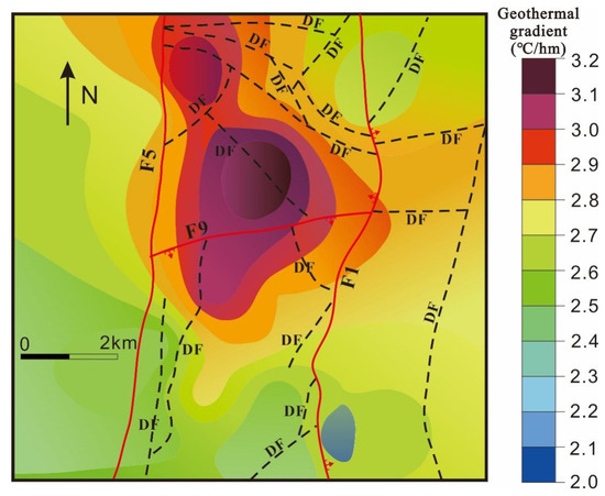
Figure 8.
Geothermal gradient in the northern Xinhu Coal Mine (modified from Zhang et al., 2014 [35]).
This pattern of tectonic thermal distribution suggests the presence of substantial Ordovician limestone layers in the northern Xinhu Coal Mine, which absorb heat from deeper metamorphic rocks, thereby forming high-temperature thermal reservoirs. Additionally, groundwater is conveyed through the tensile fractures north of the F9 fault, interfacing with the limestone thermal reservoirs and establishing strong hydraulic connection between the coal seam and the limestone thermal storage. Consequently, this interaction is characterized by a distinct distribution of high geothermal temperature gradients.
5.3. Heat-Accumulation Model of Geothermal System
Hydrothermal geothermal systems are generally influenced by stratigraphy, lithology and tectonics, and tectonic faults are the dominant channel for heat exchange between different strata at depth [40,41]. Combined with these geological conditions and the distribution characteristics of the geothermal gradient in the northern area, this study proposed a genetic mechanism model of the geothermal system in the northern Xinhu Coal Mine (Figure 9). The model indicates that the high geothermal gradient in the northern area originates from the combined action of deep heat conduction and the upwelling of geothermal water.
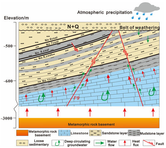
Figure 9.
Heat-accumulation model of hydrothermal geothermal system in the northern Xinhu Coal Mine.
Water-conducting extensional faults are widely developed in the northern Xinhu Coal Mine, providing an effective hydraulic connection between different strata. In addition, thick layers of Ordovician limestone underlie the coal strata. These geological features together form the foundation for the high geothermal gradient observed in the northern area. Compared to coal and sandstone, limestone has a higher thermal conductivity and acts as an efficient heat-transfer medium. It can preferentially absorb heat conducted from deeper metamorphic rock layers. As the temperature gradually increases, a high-quality, water-rich thermal reservoir is formed below the coal seam, with a temperature of approximately 51.7 °C. The thermal storage environment in this study area is relatively closed, and the geothermal water undergoes a prolonged circulation process, manifested as deeply circulating karst geothermal water. The circulation depth of the geothermal water reaches about 1279 m, during which it exchanges heat with the surrounding rocks, resulting in the formation of high-temperature geothermal water. During deep circulation and convection, heated groundwater rises along water-conducting faults (e.g., the F9 and F1 faults) due to the combined effects of thermodynamic forces and ground pressure. This process transports heat from deeper layers to the coal strata, significantly increasing the geothermal gradient in the areas surrounding the faults.
6. Conclusions
- (a)
- The chemical composition of geothermal waters in the Xinhu Coal Mine, Huaibei Coalfield, indicates that cations are predominantly Na+ and K+, while anions are primarily Cl−, SO42−, and HCO3−. The geothermal waters are classified as the Na-K-Cl-SO4 type. The hydrochemical analysis and Gibbs model reveal that the chemical composition of the water is mainly controlled by evaporation and concentration, and there is a phenomenon of salt rock dissolution.
- (b)
- Using the SiO2 geothermal temperature-scale method, we estimate the average temperature of the thermal reservoir in the Xinhu Coal Mine to be 51.7 °C, with the temperature of the sandstone layer at 46.8 °C. This shows the geothermal characteristics of deep high-temperature groundwater rising. The average circulation depth of the Ordovician limestone is determined to be 1279 m, indicative of karstic geothermal waters undergoing deep circulation.
- (c)
- Analysis of the geothermal gradient distribution in the Xinhu Coal Mine reveals an average gradient of 27.2 °C/km across the entire area, falling within the typical range for geothermal gradients. Notably, in the region west of fault F1 and north of fault F9, the geothermal gradient is significantly higher, suggesting the presence of robust hydrothermal circulation in these areas.
- (d)
- The distribution characteristics of the high geothermal gradient in the northern area of Xinhu Coal Mine are attributed to the combined effects of deep thermal conduction and convective heat transfer from geothermal water. The spatial distribution of geothermal gradients is comprehensively influenced by the lithological configuration and fracture structures. Normal faults such as F1 and F9, which cut through the Ordovician strata, establish hydrothermal channels that facilitate both water migration and heat transfer.
Author Contributions
Methodology, M.Q., K.Y., Z.W., Z.Z. and Z.S.; Formal analysis, M.Q. and B.Z. (Baoxin Zhang); Investigation, M.Q., K.Y., B.Z. (Baoxin Zhang), Z.Z. and Z.S.; Resources, B.Z. (Bo Zhang), K.Y., G.Z., Z.Z. and Z.S.; Writing—original draft, M.Q.; Writing—review & editing, B.Z. (Bo Zhang) and K.Y.; Supervision, G.Z. and Z.W.; Funding acquisition, B.Z. (Bo Zhang) and K.Y. All authors have read and agreed to the published version of the manuscript.
Funding
This research was financially supported by the Open Project of Weihai Key Laboratory of Energy and Mineral Resources Investigation and Evaluation (No. LDKF-2023WH-09), Innovative Training Program for College Students, China University of Mining and Technology (No. 202410290275Y), the National Natural Science Foundation of China (42202138), and the Natural Science Foundation of Jiangsu Province (BK20221145), and the China Postdoctoral Science Foundation (2024M762722). The authors express their gratitude to Huaibei Mining Group Co., Ltd. for sample collection and data support.
Data Availability Statement
The original contributions presented in this study are included in the article. Further inquiries can be directed to the corresponding author.
Conflicts of Interest
Author Bo Zhang was employed by the company Pingdingshan Tianan Coal Mining Co., Ltd. The remaining authors declare that the research was conducted in the absence of any commercial or financial relationships that could be construed as a potential conflict of interest.
References
- Azwardi; Andaiyani, S.; Igamo, A.M.; Wijaya, W.A. The Environmental Impacts of Natural Resources Depletion. In Proceedings of the 6th International Conference on Indonesian Architecture and Planning (ICIAP 2022), Yogyakarta, Indonesia, 13–14 October 2022; Springer: Singapore, 2022; pp. 705–714. [Google Scholar]
- Attanayake, K.; Wickramage, I.; Samarasinghe, U.; Ranmini, Y.; Ehalapitiya, S.; Jayathilaka, R.; Yapa, S. Renewable energy as a solution to climate change: Insights from a comprehensive study across nations. PLoS ONE 2024, 19, e0299807. [Google Scholar] [CrossRef] [PubMed]
- Yolcan, O.O. World energy outlook and state of renewable energy: 10-Year evaluation. Innov. Green Dev. 2023, 2, 100070. [Google Scholar] [CrossRef]
- Islam, M.T.; Nabi, M.N.; Arefin, M.A.; Mostakim, K.; Rashid, F.; Hassan, N.M.S.; Rahman, S.M.A.; McIntosh, S.; Mullins, B.J.; Muyeen, S.M. Trends and prospects of geothermal energy as an alternative source of power: A comprehensive review. Heliyon 2022, 8, e11836. [Google Scholar] [CrossRef] [PubMed]
- Vargas, C.A.; Caracciolo, L.; Ball, P.J. Geothermal energy as a means to decarbonize the energy mix of megacities. Commun. Earth Environ. 2022, 3, 66. [Google Scholar] [CrossRef]
- Gutiérrez-Negrín, L.C. Evolution of worldwide geothermal power 2020–2023. Geotherm. Energy 2024, 12, 14. [Google Scholar] [CrossRef]
- Lund, J.W.; Toth, A.N. Direct utilization of geothermal energy 2020 worldwide review. Geothermics 2021, 90, 101915. [Google Scholar] [CrossRef]
- Zhang, J.; Chen, L.; Sun, Y.; Xu, L.; Zhao, X.; Li, Q.; Zhang, D. Geothermal resource distribution and prospects for development and utilization in China. Nat. Gas Ind. B 2024, 11, 6–18. [Google Scholar] [CrossRef]
- Wang, Y.; Liu, Y.; Dou, J.; Li, M.; Zeng, M. Geothermal energy in China: Status, challenges, and policy recommendations. Util. Policy 2020, 64, 101020. [Google Scholar] [CrossRef]
- He, Z.; Feng, J.; Luo, J.; Zeng, Y. Distribution, exploitation, and utilization of intermediate-to-deep geothermal resources in eastern China. Energy Geosci. 2023, 4, 100187. [Google Scholar] [CrossRef]
- Wang, G.; Lin, W.; Zhang, W.; Liang, J.; Wang, W. Evaluation of geothermal resources potential in China. Acta Geosci. Sin. 2017, 38, 449–459. [Google Scholar]
- Zhang, K.; Wang, Z.; Yao, B.; Zhang, S.; Jiang, G.; Yang, L. Distribution characteristics of geothermal flow in the Fuyang Basin and surrounding areas of Anhui Province. Geol. Sci. 2024, 59, 375–387. [Google Scholar]
- Wang, L.; Wei, Y.; Cheng, H.; Kang, J.; Liao, A. Characteristics and potential evaluation of geothermal resources in Anhui of Yangtze River Economic Zone. Geol. China 2022, 49, 1765–1777. [Google Scholar]
- Wang, J.; Kong, Y.; Duan, Z.; Zhang, J.; Luo, X.; Huang, Y.; Luo, N.; Cheng, Y.; Zhou, N.; Zhang, W.; et al. Development and utilization of geothermal resources and energy storage technology in coalfield areas under the “double carbon” target. Coal Geol. Explor. 2023, 51, 1–11. [Google Scholar]
- Zhang, L.; Lu, H. Investigation Method and Utilization Mode of Geothermal Resources in Abandoned Mines in Huainan and Huaibei. Int. J. Geosci. 2022, 13, 415–425. [Google Scholar] [CrossRef]
- Huang, L.; Wei, Y.; Chen, Z.; Wang, Z.; Liu, Y.; Sun, L.; Li, C. Thermal Hazard Evaluation and Prediction in Deep Excavations for Sustainable Underground Mining. Sustainability 2024, 16, 10863. [Google Scholar] [CrossRef]
- Zhang, J.; Liu, H.; Zhou, N.; Yan, H.; Li, B. Concept and technical system of deep mine phase change heat storage function filling heat extraction. J. Min. Saf. Eng. 2023, 40, 933–944. [Google Scholar]
- Anderson, A.; Rezaie, B. Geothermal technology: Trends and potential role in a sustainable future. Appl. Energy 2019, 248, 18–34. [Google Scholar] [CrossRef]
- Cui, G.; Niu, Z.; Zhao, D.; Kong, Y.; Feng, B. High-temperature hydrothermal resource exploration and development: Comparison with oil and gas resource. Gondwana Res. 2023, 122, 306–314. [Google Scholar] [CrossRef]
- Wang, G.; Lin, W. Formation mechanism and genesis model of the main hydrothermal geothermal systems in China. Acta Geol. Sin. 2020, 94, 1923–1937. [Google Scholar]
- Li, Y.; Yu, K.; Wan, Z.; Zhang, Y.; Wang, Z.; Shi, P.; Zhen, Z.; Zhang, B. Regional structural controls on a hydrothermal geothermal system in the eastern Pingdingshan coalfield, China: A comprehensive review. Geothermics 2024, 123, 103131. [Google Scholar] [CrossRef]
- Li, J.; Sun, D.; Li, Z.; Cao, N.; Tong, K.; Liao, J.; Zhang, Z.; Dong, J.; Zhang, X. Genesis model of hydrothermal geothermal resources in Sichuan Basin. Geol. Sci. 2023, 58, 438–460. [Google Scholar]
- Barcelona, H.; Lelli, M.; Norelli, F.; Peri, G.; Winocur, D. Hydrochemical and geological model of the Bañitos-Gollete geothermal system in Valle del Cura, main Andes Cordillera of San Juan, Argentina. J. S. Am. Earth Sci. 2019, 96, 102378. [Google Scholar] [CrossRef]
- Zheng, R.; Xiong, C.; Ping, J.; Su, X.; Zhao, J.; Liu, J. Hydrogeochemical characteristics and hydrothermal genesis model of the fracture zone in the southeastern foothills of Taihang Mountains. Hydrogeol. Eng. Geol. 2024, 51, 43–56. [Google Scholar]
- Qu, J.; Lin, J.; Wang, J.; Yan, T.; Ren, K.; Zhou, J.; Li, Y. Analysis of the evolution and causes of groundwater chemistry after ecological water replenishment of the Jialu River, China. Sci. Rep. 2024, 14, 18759. [Google Scholar] [CrossRef]
- Chen, K.; Liu, Q.; Peng, W.; Liu, X. Source apportionment and natural background levels of major ions in shallow groundwater using multivariate statistical method: A case study in Huaibei Plain, China. J. Environ. Manag. 2022, 301, 113806. [Google Scholar] [CrossRef]
- Marandi, A.; Shand, P. Groundwater chemistry and the Gibbs Diagram. Appl. Geochem. 2018, 97, 209–212. [Google Scholar] [CrossRef]
- Poznanović Spahić, M.; Marinković, G.; Spahić, D.; Sakan, S.; Jovanić, I.; Magazinović, M.; Obradović, N. Water–rock interactions across volcanic aquifers of the Lece Andesite Complex (Southern Serbia): Geochemistry and environmental impact. Water 2023, 15, 3653. [Google Scholar] [CrossRef]
- Zhang, J.; Chen, L.; Hou, X.; Zhang, M.; Hu, Y. Hydrogeochemical characteristics of Ordovician karst water in North China coalfields and its significance for geothermal indication. J. China Coal Soc. 2023, 48, 3831–3844. [Google Scholar]
- Kushnir, A.R.L.; Loewer, M. From exploration to operation: Research developments in deep geothermal energy. Geotherm. Energy 2020, 8, 15. [Google Scholar] [CrossRef]
- Meng, F.; Liang, X.; Xiao, C.; Wang, G. Multi-index-weighted geothermometer estimation of geothermal reservoir temperature: Applications and future directions. Renew. Energy 2024, 221, 119792. [Google Scholar] [CrossRef]
- Taide, V.Y.; Sinharay, R.K.; Chavan, H.K.; Dandge, D.B. Selection of suitable geothermometers for predicting the subsurface temperatures with higher accuracy: A study based on globally distributed geothermal field data. Geothermics 2024, 122, 103088. [Google Scholar] [CrossRef]
- Ma, F.; Sun, Z.; Sun, Z.; Wang, X.; Lu, R.; Gu, H.; Guo, J.; Cai, X. Temperature measurement used for 4000-m depth drilling and geothermal characteristics in Jiaodong Peninsula, China. Environ. Earth Sci. 2017, 76, 728. [Google Scholar] [CrossRef]
- Wang, Y.; Bai, Y.; Wang, L.; Guan, J.; Wang, Y.; Wang, Z.; He, J.; Hu, S. Exploration process and genesis mechanism of deep geothermal resources in the North Jiangsu Basin, East China: From nothing to something. Front. Earth Sci. 2021, 9, 784600. [Google Scholar] [CrossRef]
- Zhang, J.; Liu, W.; Liu, S.; Yin, G. Analysis of geothermal distribution characteristics and influencing factors in Xinhu Coal Mine. Sci. Technol. Vis. 2014, 14, 136–137+198. [Google Scholar]
- Artemieva, I.M.; Thybo, H.; Jakobsen, K.; Sørensen, N.K.; Nielsen, L.S. Heat production in granitic rocks: Global analysis based on a new data compilation GRANITE2017. Earth-Sci. Rev. 2017, 172, 1–26. [Google Scholar] [CrossRef]
- Abbady, A.G. Evaluation of heat generation by radioactive decay of sedimentary rocks in Eastern Desert and Nile Valley, Egypt. Appl. Radiat. Isot. 2010, 68, 2020–2024. [Google Scholar] [CrossRef]
- Łuszczak, K.; Persano, C.; Braun, J.; Stuart, F.M. How local crustal thermal properties influence the amount of denudation derived from low-temperature thermochronometry. Geology 2017, 45, 779–782. [Google Scholar] [CrossRef]
- Zhu, C.; Xu, T.; Qiu, N.; Chen, T.; Xu, M.; Ding, R. Distribution characteristics of the deep geothermal field in the Sichuan Basin and its main controlling factors. Front. Earth Sci. 2022, 10, 824056. [Google Scholar] [CrossRef]
- Deng, F.; Pei, P.; Ren, Y.; Luo, T.; Chen, Y. Investigation and evaluation methods of shallow geothermal energy considering the influences of fracture water flow. Geotherm. Energy 2023, 11, 25. [Google Scholar] [CrossRef]
- Yu, K.; Wan, Z.; Li, Y.; Ju, Y.; Wang, Z.; Zhang, Y.; Zhao, S.; Zhao, K. Thermal Evolution, Hydrocarbon Generation, and Heat Accumulation of a High Geothermal Coalfield: A Case Study of Pingdingshan Coalfield, China. ACS Omega 2023, 8, 15488–15500. [Google Scholar] [CrossRef]
Disclaimer/Publisher’s Note: The statements, opinions and data contained in all publications are solely those of the individual author(s) and contributor(s) and not of MDPI and/or the editor(s). MDPI and/or the editor(s) disclaim responsibility for any injury to people or property resulting from any ideas, methods, instructions or products referred to in the content. |
© 2025 by the authors. Licensee MDPI, Basel, Switzerland. This article is an open access article distributed under the terms and conditions of the Creative Commons Attribution (CC BY) license (https://creativecommons.org/licenses/by/4.0/).