Article

Geothermal Potential of Pumping–Injecting Doublet Wells

Department of Geotechnology, Mining and Environment, Faculty of Natural Sciences and Engineering, University of Ljubljana, Aškerčeva 12, 1000 Ljubljana, Slovenia
*
Author to whom correspondence should be addressed.
Energies 2024, 17(5), 980; https://doi.org/10.3390/en17050980
Submission received: 18 December 2023 / Revised: 11 February 2024 / Accepted: 19 February 2024 / Published: 20 February 2024
(This article belongs to the Section A: Sustainable Energy)

Abstract

:
A characteristic of the Pannonian Basin is its strong geothermal flow. Geothermal water is present in aquifers in the Miocene and Pliocene sediments of the Lendava, Murska Sobota, and Mura formations, as well as in pre-Neogene sedimentary rocks, at a depth of several 1000 s to several 100 s of meters. The water from the deep Miocene and Pliocene aquifers is mainly pumped for use in the spas of the region, which is separated by national borders. Pumping water from the aquifers lowers the hydraulic head of the water in the aquifers. The consequence of the drop in hydraulic head is a reduction in the yield of the aquifers, which has a negative impact on the neighboring wells. In order to prevent the effects of this influence—especially in the case of transboundary influences, as in our case—the construction of an additional well was proposed, through which the cooled water would be pumped back into the deep aquifer. For the specific case of the Terme Korovci project, which is located directly on the national border, a 3D structural model of the aquifer was created. The hydrogeological and thermal properties of the aquifer were determined on the basis of the lithological profile of the wells in the region, along with well logs and pumping tests. As detailed data on the thicknesses of the layers have not been available until now, we have envisaged several scenarios for different layer thicknesses. As will be evident from our data, in the case of a 10 m-thick layer, the temperature falls to below 70 °C in fewer than 6000 days, and this period extends with increasing thickness such that with a 200 m-thick layer, the period extends to well over 100,000 days. The findings are important because the potential investor requires at least 20 years of operation of the pumping–reinjection pair of wells.

1. Introduction

Based on environmental and mining legislation, in the Republic of Slovenia, it is possible to put the geothermal potential of underground waters to use in two separate ways: the first is in accordance with the law regarding waters, which does not include its return to the water-bearing strata system; the second, which is in accordance with mining law, predicts the use of pumped-out water and the extraction of its thermal energy, followed by returning the water to its original system. In order to preserve the underground water balance, recently, even in the case of the first method, the return of cooled underground water to the usable part of the aquifer system has been required. No matter which of the two methods is used, it is necessary to operate with respect to the lasting use of water and its thermal energy, as stated in the second water-related directive set by the EU. This is why physical and legal persons in the Republic of Slovenia, who are in the middle of the procedure of acquiring a concession for the use of a geothermal source, must have certain documentation drawn up, stating the natural qualities of the given area with emphasis on the geological, hydrological, geophysical, and drilling work necessary to enable the permanent use of the water source in question. In the Republic of Slovenia, and from a geothermal perspective, the northeast part of the country is generally seen as presenting the most opportunity (Figure 1 and Figure 2). The research in this area is quite good seeing as, for roughly 40 years of the 20th century, it has included the manufacture of carbohydrates. The first experiments aimed at obtaining the latter go as far back as the second half of the 19th century, when people in Peklenica and Selnica, Međimurje County, first began obtaining oil from surface springs. From here on, the research expanded northwards to include Prekmurje, and eastwards to include Dravsko polje. Until the year 1946, the surrounding areas of Lendava were researched by many stockbroking companies, mainly foreign oil companies. Especially intense geological, geophysical, and mining research went on throughout World War II, wherein two oil–gas fields were discovered: one in Dolina (in 1942) and one in Petišovci (1943). While carrying out oil–gas investigations, it was revealed that these areas had a high geothermal potential. The possibility and presence of geothermal water sources was irrevocably proven through research drilling originally carried out to find oil and gas. Based on this information, in the second half of the 20th century, tourist activity increased, chiefly relying on health-related tourism, which was, in turn, based on the health-related effects of thermomineral waters pumped from deep water sources [1,2]. The use of the energetic potential of the latter, however, started relatively late—namely, a couple of years ago—in spite of a few experiments during the energy crisis of the 1970s. The larger part of the use of this geothermal potential uses water, which is pumped out of its thermomineral sources without eventually being directed back to them. Here, it must be noted that possible negative influences on the water balance in this area have not yet been completely investigated but are most likely present. Because the Nivo corporation from Celje, which focuses on building and ecology, intends to put this thermomineral water to use by attempting to gain energy from it, it makes sense that the pumped water is stripped of part of its heat and then put back into the water-bearing system. This method of use has no negative consequences on the water balance and enables the long-term use of water with energetic purposes in mind, with examples of the latter including the heating of public and private living areas.
At the same time, we must note that further research has not been carried out as this project is currently at a standstill due to a lack of investment funds.

2. Materials and Methods

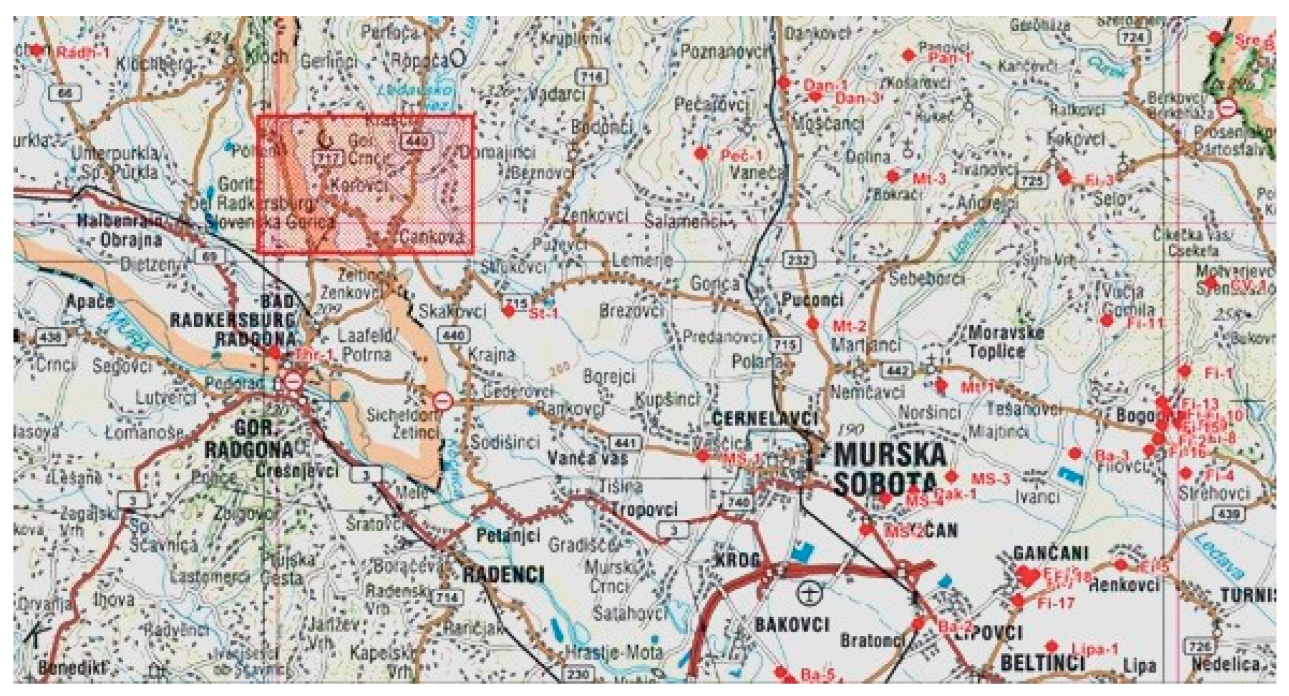
2.1. Geographical Overview

Pomurje is a lowland region along the Mura River in the extreme northeastern part of Slovenia on the border with Austria and Hungary. The landscape is mostly agricultural, and the largest cities are Murska Sobota and Lendava. Morphologically, the area is poorly divided and mostly flat. Geographically, it is divided into the following areas: the hilly area north of Murska Sobota is Goričko, south of Murska Sobota on the left bank of the Mura lies Ravenska, and southeast is Dolinsko polje (together forming Prekmursko polje). Around Lendava is the small hilly area of Lendavske Gorice. The Korovci area is located in the western part of Goričko next to the Austrian–Slovenian state border. The village of Korovci is located in the municipality of Cankova, which borders the municipality of Puconci to the east, the municipality of Tišina to the south, the Slovenian–Austrian border to the west, and the municipality of Rogašovci to the north (Figure 1). The type of landscape is the Pannonian hills, i.e., a hilly region bounded in the south by the Murska plain and elsewhere by the national borders with Austria and Hungary. The surface is rugged, with an altitude between about 170 and 420 m above sea level. The lowest areas are located in the valleys of the Ledava River and its tributaries. The hydrographic network is formed by the River Ledava and the border stream Kučnica. The Ledava River is a few tens of kilometers long (around 70 km) and originates in Austria as the Lendva Bach, which flows through Goričke, Murska Sobota, and Lendava all the way to the triple border between Hungary, Slovenia, and Croatia, where it flows as a left tributary into the Mura River. The Ledava River often floods; it is characterized by the fact that it reacts very quickly to rainfall peaks during the dry season. With the aim of mitigating the effects of high waters, in the 1970s, the Ledava was dammed near Krašči, thereby creating the artificial Lake Ledava. The Ledava is characterized by a rainy regime, with the highest flow in March and November and the lowest flow in the dry periods of August and September [3]. The area is characterized by the temperate continental climate of eastern Slovenia or the sub-Pannonian climate. The average annual amount of precipitation in the considered area is around 805 mm. The maximum precipitation is typically in summer, and the minimum precipitation is typically in the winter period. The average annual air temperature is 9.6 °C. The average January temperature between 1971 and 2000 was between −4.9 and 2.5 °C, and the average July temperature was between 19 and 25.9 °C during the same period [4].

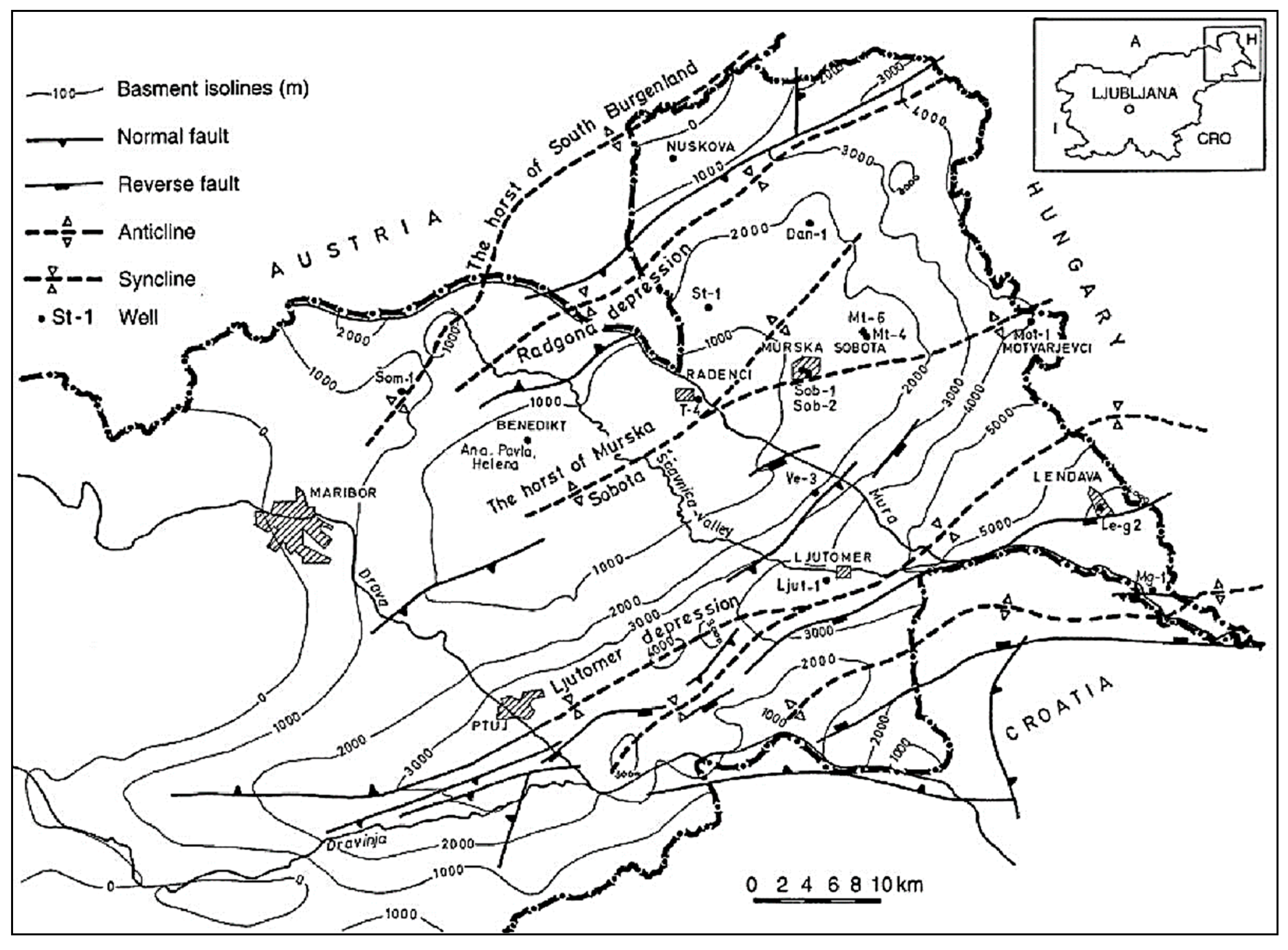
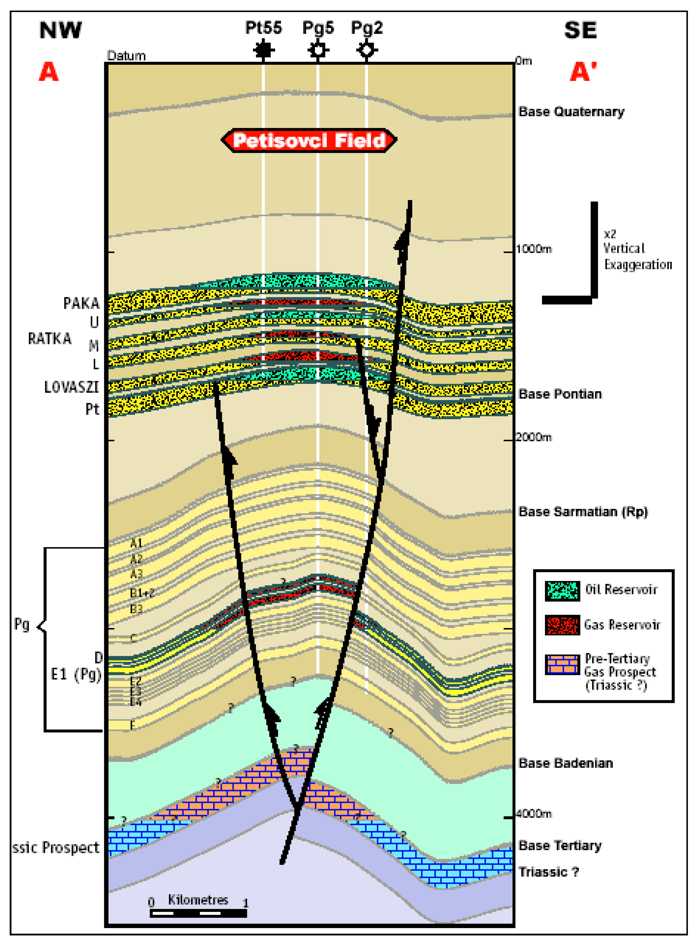
2.2. Geological Overview

An influential area of the geothermal energy source lies in the Mura Depression. The latter represents one of the fringe depressions of the south part of the Panonic region pool, i.e., its eastern and southeastern components, which lie in the areas of Hungary, Croatia, Slovenia, and part of Austria. The Mura Depression spreads out towards the northeastern part of Slovenia. This part of Slovenia includes the following, facing south: Goričko, Lendavske Gorice, the Murska Plane, Slovenske Gorice, the Dravska Plane, Dravske Gorice, and Haloze. The area of the Mura Depression was entirely formed during the Miocene epoch with the sinking of the Neogene-based base of the eastern extension of the eastern and southern Alps. The sinking of individual units of the base did not take place simultaneously; i.e., the base was disintegrated into specific blocks in which Neogene sediments were formed of differing age and thickness. This depression is also divided into four tectonic units (Figure 2), which follow one another from the northeast to the southeast [5,6,7,8,9]:
  • The Maribor–Radgonje Depression;
  • The Murska Sobota Massif;
  • The Ptuj–Ljutomer Depression;
  • The Ormož–Selniška Anticline.
Tectonic units differ from one another based on sediment thickness, type, and age of Tertiary (Neogene A/N) sediments, as well as the base of the Tertiary era and its tectonic properties. The Mura Depression is filled with Tertiary and Quaternary sediments. The base of the Tertiary era and the edge of the Mura Depression are composed of metamorphological, sedimentary, and magmatic rocks of pre-Cambrian, Paleozoic, and Mesozoic ages. The area of the Mura Depression had previously had several deep wells introduced to it while it was being investigated for the possible use of its oil and gas. It was then discovered that the thickness of the Tertiary sediments is variable. Based on much information from the wells, the Tertiary sediments were classified into three formations [10] (Figure 3): the oldest is the formation of Murska Sobota, and trailing behind it, in descending order, are the formation from Lendava and the formation from Mura. The aforementioned formations are not equally developed everywhere and have been sorted into individual groups based on their lithological makeup. The formulation from Murska Sobota encompasses the era from the bottom and middle Miocene to the Sarmat and lower Panonic. It is made up of carbonates, conglomerates, sandpits, and hard-to-sandy marls. The formation from Lendava begins in the early Panonic era and encompasses the lower Pont. Lithologically, these are clastic rocks, namely, sandpits and marls. The Mura formation encompasses the era of the upper Pont. In the lower parts, it is made up of sandpits and marls, exchanging with sands and clay, and in the upper levels, one can find sands and clays with charcoal and gravel fractions [10,11].
From a geological point of view, the development of all three formations can be expected in a narrower area, i.e., the Murska, Lendava, and Murskosoboska formations. In the area of Cankova and Korovci, we can see the youngest layers of the Quaternary period on the surface, which consists of Quaternary sandy clay, lying on the fluvioglacial moorland. Below them are Neogene sediments of the older Miocene age, which are most likely followed by Triassic dolomites, which pass into a metamorphic pre-Neogene base. In the area under consideration, it is precisely these last metamorphic rocks that have the oldest age (Cambrian). Dolomitic-to-calcareous carbonates are deposited on them, which are probably quite fractured (Triassic). The entire carbonate stack contains elements of basal breccias and broken zones of erosional remains in contact with the metamorphic massif. The Miocene strata in this area have a clastic development that is typical of this part of the edge of the Pannonian Basin. The area of the pair of wells lies on the southeastern flank of the Radgona Depression, which represents one of the parts of the Mura Depression. The Mura Depression, as part of the Pannonian Basin, in geotectonic terms, is the eastern extension of the eastern and southern Alps, formed during the Oligocene and Neogene by the subsidence of the pre-Neogene structure. The sinking of individual tectonic units of the pre-Neogene bedrock did not take place simultaneously.

2.3. Hydrogeological Situation

In the area of the pair of wells and beyond, it is possible to split the water carriers and water-carrying systems into the following units [1,12,13,14,15]. Beginning from the surface, the first water carrier is a sandy pile of Mura, i.e., a water carrier in the gravel, sandy, and oozing layers of the Quaternary and Neogene periods, followed by water carriers within the upper Neogene sediments, the temperature of which increases with depth. The third water-carrying system can be found in deeper thermal water-carrying Neogene sediments, and for the fourth, we can potentially include water carriers within a pre-Neogene base. The third water carrier is closed according to hydrodynamic type, with a medium thickness of over 200 m, and can be found underneath the thick roofing layers and other, higher-lying water carriers. The thickness and development of the fourth water-bearing system is not completely apparent. The first alluvial water carrier is made up of Quaternary sediments and is hydrodynamically connected to the River Mura, as well as being pumped from it. The thickness of the water-bearing system in the Quaternary sediments ranges from a few meters to over 40 m in the middle part of the Mura Plane [16]. The coefficient of hydraulic transition is somewhere between 10−4 m/s and 10−2 m/s. The second water-bearing system is under constant pressure and is composed of Neogene sediments, mostly sands, gravels, and sandy pits. Its ability to let water through becomes smaller and smaller with increasing depth due to the settling and lithification of the sediments. It is pumped in the direction of the breaking line, directed from northeast to southwest, and at the fringes of the Mura Depression (Goričko). The typical transition rates are from 10−4 m/s to 10−6 m/s, with water temperatures ranging from 20 to 700 °C. Beneath this lies a third water-bearing system made up of the Lendava and Murska Sobota formations. The hydraulic passing rate is 10–100× worse than that of the sediments of the Mura formation, and in the area where dolomites appear, it is similar to that of the former systems. Some authors have combined the second and third systems into a group denoted as Termal I [9,16].
The fourth water-bearing system may include carbonates from the Mesozoic and/or metamorphic rocks of the upper part of the Paleozoic. This water-carrying system is also known as Termal II, and its depth most likely varies between ten and a couple of hundreds of meters, with the temperature reaching as high as 175 °C. As an example, we can cite Ljut-1 near Ljutomer, where carbonated development of the Mesozoic was proven at a depth of 4004 m and was not restricted to just the surroundings of this particular well. The measured temperature was approximately 173 °C. The salty waters from this system most likely originate from the sea [9]. Our goal unit is a dolomite of the Triassic era, together with the lower Miocene water carriers lying directly above it. Our estimations indicate that the latter are connected as part of a hydrodynamic whole, representing parts of the third water-bearing system. Based on structural data from the surrounding wells, we went on to produce an in-depth map of the upper limits of the third water-bearing system (Figure 4).

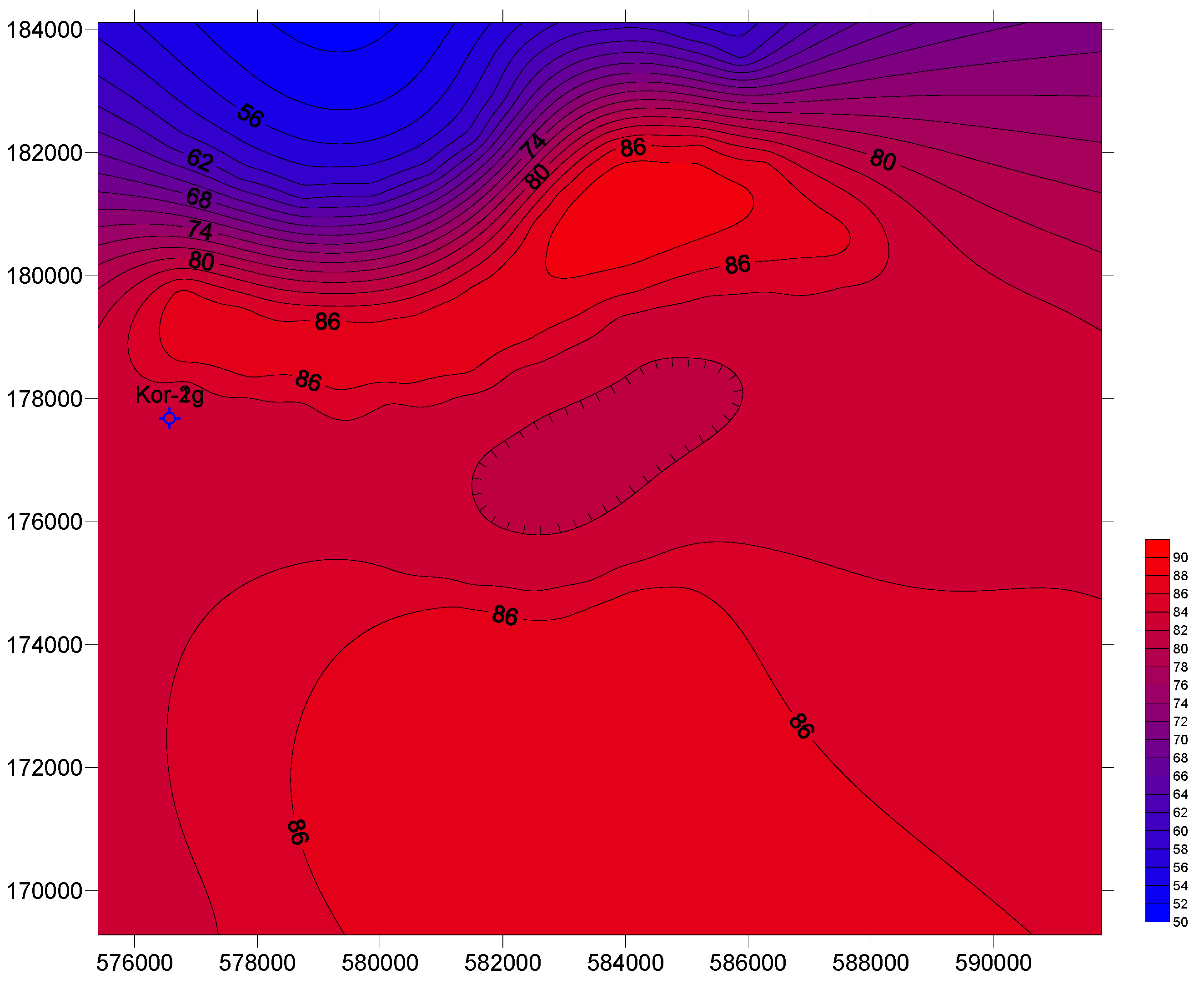
2.4. Geothermal Situation
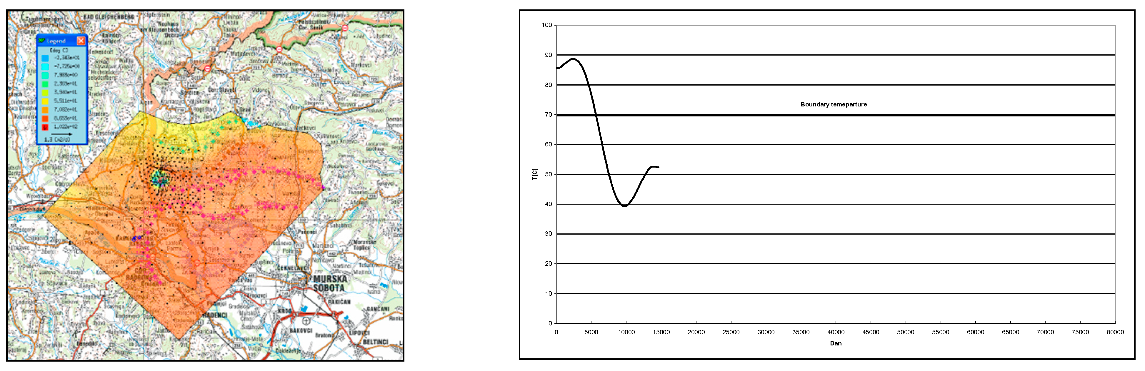
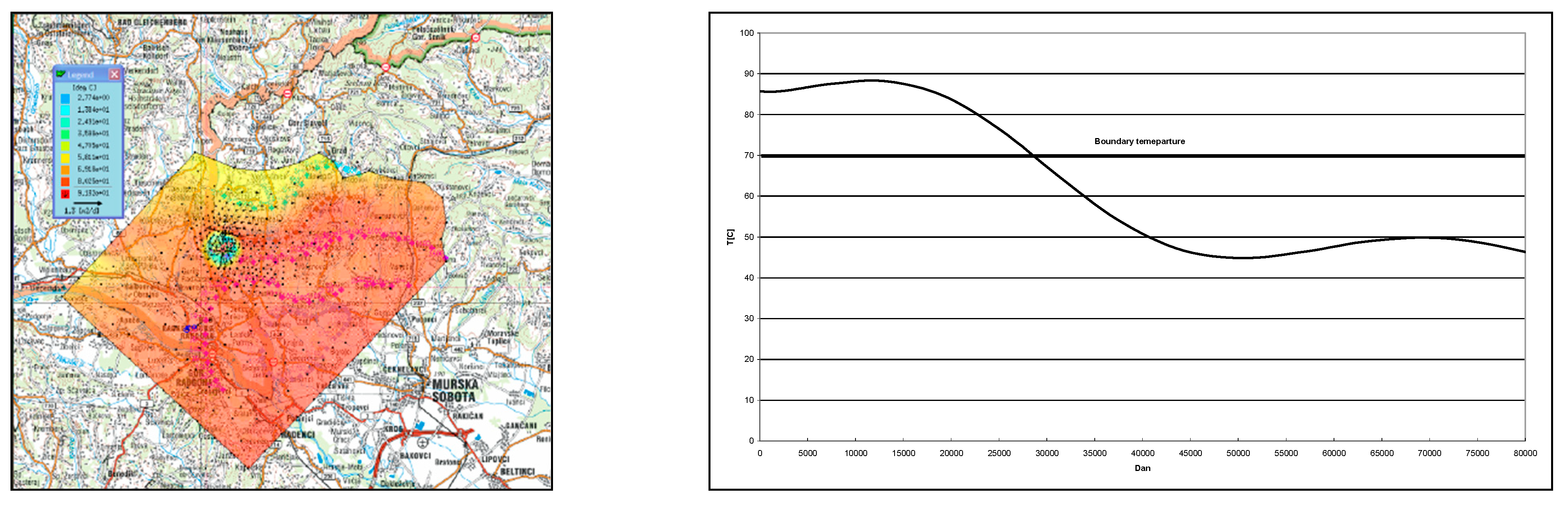
In the broader considered area of northeastern Slovenia, various authors have reported values of increased heat flow. For example, the researchers Dovenyi [17], Ravnik [18], Lenkey [19], and Rajver [20] reported values between 60 and 70 mW/m2. In recent studies, elevated heat flow of above 120 mW/m2 characterized the Murska Sobota high from Lenart to Moravske Toplice and the Pečarovci–Dankovci area, which may be explained by the convection zones in the relatively shallow-lying pre-Neogene basement, as has been proven in Benedikt and as is possible beneath Murska Sobota and Moravske Toplice. A smaller anomaly, above 110 mW/m2, is located in Lendava [21]. Nador et al. [21] also noted that the measured temperatures at 1000 m were consistent with the recorded heat flow. A high eastern anomaly exists in the area from Lenart via Benedikt to Moravske Toplice, with values over 65 °C that have so far been confirmed by temperature measurements in the boreholes in Benedikt, Murska Sobota, and Moravske Toplice [21]. The anomaly in Benedikt, Murska Sobota, and Moravske Toplice is most likely due to some deep fracturing in the metamorphic rocks in the basement, which enables heat to be transferred by convection from the depths towards the Neogene layers [21].
Based on the above, in the influential area of pumping–injection pairs, it is taken for granted that the heat flow must be greater than 100 mW/m2. For an estimation of the thermal conductivity of the water-bearing layers, we assumed that the latter are made up of a homogeneous isotropic mass of flint, sand, and clay; thus, we calculated their thermal conductivity to be λs = 5.3 W/mK [12], and for the water, we recorded a value of 0.65 W/mK. For an illustration of the temperature field in an influential area of the pumping–injection pair in Korovci, we modeled the linear functional dependency of temperature on depth, with our basis being the measurement data obtained from well Kor-1, namely, for depths between 500 and 1900 m (Figure 5). Here, this is shown through linear Equation (1):
T = 3.66 · 1 0 2 ° C m · x + 15.368   ° C ,
where x is the depth. With the aid of the former, we were able to obtain the temperature field for medium values of the depth of the water-bearing system, which we intend to use for geothermal energy with the aid of a pumping–injection pair (Figure 6). According to the depth of the well and the depth of the water carriers, this would be classified as the third water-bearing system to fit our previous definitions.

3. Results

Our aim was to evaluate the pumping–injection pair’s hydrodynamic and temperature water-bearing fields. The purposes of this evaluation were as follows [8,22,23,24,25,26]:
  • To determine whether our pumping and pouring in any way affects the pumping on the Austrian side;
  • To ascertain the possible influences of pumping wells in the Austrian Gornja Radgona;
  • To evaluate the influence of the pumping–injection pair on the temperature field in the water carrier.
Because detailed data were not available at the time of modeling, we constructed multiple scenarios to study these influences and their respective calculations, the data for which are shown in Table 1.
For the production of a model, the model of final elements in FEFLOW version 7.30 was used. Due to the available possibilities enabled only by the 2D modeling of heat transfer, the flow and heat model was constructed in 2D space. As has already been denoted, the water-carrying system is mainly located in Hungary, where rocks that are hydraulically connected to the water-carrying system break to the surface. Data regarding the amount of pumping were unavailable; therefore, we used a border with a constant level, which was then moved as far away as possible from the pumping pair to represent pumping from the northeast. The reason for the former lies within the Dirichlet border, which, no matter the conditions within the water carrier, ensures unlimited amounts of water sinks within the system. This effect is best avoided by setting the border as far away from the sinks as possible. A simple hydraulic conceptual model is shown in Figure 7, where the pumping of the system from the northeast has been replaced with a Dirichlet border of a constant level (denoted by a blue color). The value of the level was estimated to be about 250 m. The distance between the injection and pumping wells is approximately 1280 m. Our intentions, with the aid of different scenarios, were to investigate the possibility of intertwined influence of different users of this water-bearing system, which can be used to pump underground waters in order to gain geothermal energy. Most of all, we were interested in determining how the use of the injection–pumping pair would influence the hydrodynamic and temperature fields [27,28].
Depictions of our calculations are shown in Figure 8, Figure 9, Figure 10 and Figure 11. As is evident from the latter, the pumping–injection pair does not influence the hydrodynamic field of the water-bearing system, but it does influence the temperature field, depending on the amount of time spent. For the needs of consumers, who require water heated to at least T = 70 °C for us to be able to call the thermal energy system successful, we used graphs to represent the changing temperatures along the pumping well. As is apparent from Figure 8, in the case of a 10 m-thick layer, the temperature falls beneath 70 °C within a time period shorter than 6000 days. With the increasing thickness of the water-carrying system, the water-cooling time at the well also increases, such that a 50 m thickness of the water-bearing system will ensure that the temperature of the water falls beneath the optimum at a time somewhere between 25,000 and 30,000 days (Figure 9), a 100 m thickness between 50,000 and 60,000 days (Figure 10), and a 200 m thickness between 100,000 and 120,000 days (Figure 11). A calculation of the hydraulic field is shown in Figure 12. As is evident from this figure, a hydrodynamic influence on the well in the Austrian Gornja Radgona is absent due to the water also being returned to the system [11].

4. Conclusions

Based on the structure of an old geological map of the northeastern part of Slovenia, we constructed a local structural geological model. The area was divided into four potential water-bearing systems. The first is Quaternary, the second two are known by the name Termal I, and the last is known as Termal II. Bearing in mind our intentions, the use of water carriers from the lower section of the Neogene is anticipated seeing as they form a multilayer water-bearing system with relatively high temperatures. During the drilling of the first well, Korovci-1, we conducted temperature measurements and correlated them with depth. Based on the depths of the structural geological model and the link between temperature and depth, we then drew up a temperature field within the third water-bearing system. Previous geothermal research indicates that the thermal flow in this area is greater than 100 mW/m2. At the wishes of the investor, curious about the potential effects of reinjected cold water on the pumped water surrounding the well, we constructed a mathematical model of this heat transfer. Because we had a 2D-only heat transfer license, we first made a “D flow” and then a “D model” of heat transfer. Based on the latter, it was determined that the pumping–injection pair in no case tampers with the water balance of the third water-bearing system, and that the temperature is dependent on the thickness of the system itself. As is evident from our data, in the case of a 10 m-thick layer, the temperature falls to below 70 °C in fewer than 6000 days, and this period is longer with increasing thickness such that with a 200 m-thick layer, the period extends to well over 100,000 days. It is our evaluation that this model will be further improved with the aid of tests to be conducted on Korovci-1; thus, an even more accurate necessary distance between the pumping and reinjection wells will be determined to ensure a functioning system for over 20 years.

Author Contributions

Conceptualization, G.V. and Ž.V.; methodology, G.V., J.Š. and Ž.V.; software, G.V. and J.Š.; validation G.V., J.Š. and Ž.V.; formal analysis, G.V. and Ž.V.; investigation, G.V. and Ž.V.; resources, G.V. and Ž.V.; data curation, G.V., J.Š. and Ž.V.; writing—original draft preparation, Ž.V.; writing—review and editing, G.V. and J.Š.; visualization, Ž.V. and J.Š.; supervision, G.V. and Ž.V. All authors have read and agreed to the published version of the manuscript.

Funding

This research received no external funding.

Data Availability Statement

The data presented in this study are available upon request from the corresponding author.

Conflicts of Interest

The authors declare no conflicts of interest.

References

  1. Rman, N.; Gál, N.; Marcin, D.; Weilbold, J.; Schubert, G.; Lapanje, A.; Rajver, D.; Benkova, K.; Nádor, A. Potentials of transboundary thermal water resources in the western part of the Pannonian Basin. Geothermics 2015, 66, 88–98. [Google Scholar] [CrossRef]
  2. Rajver, D. Map of Surface Heat-Flow Density. Geological Atlas of Slovenia, 2nd ed.; Geological Survey of Slovenia: Ljubljana, Slovenia, 2016. [Google Scholar]
  3. Brilly, M. Matematični Model Za Simulacijo Toka Podtalnice Mursko-Ljutomerskega Polja; FAGG, Laboratorij Za Mehaniko Tekočin: Ljubljana, Slovenia, 1983. [Google Scholar]
  4. Available online: https://meteo.arso.gov.si/uploads/probase/www/climate/table/sl/by_location/murska-sobota/climate-normals_71-00_murska-sobota.pdf (accessed on 12 January 2024).
  5. Tóth, G.; Rman, N.; Rotár-Szalkai, Á.; Kerékgyártó, T.; Szőcs, T.; Lapanje, A.; Černák, R.; Remsík, A.; Schubert, G.; Nádorm, A. Transboundary fresh and thermal groundwater flows in the west part of the Pannonian Basin. Renew. Sustain. Energy Rev. 2016, 57, 439–454. [Google Scholar] [CrossRef]
  6. Rman, N.; Lapanje, A.; Rajver, D. Analysis of thermal water utilization in the northeastern Slovenia. Geologija 2012, 55, 225–242. [Google Scholar] [CrossRef]
  7. Prestor, J.; Rman, N.; Lapanje, A.; Szőcs, T. Benchmarking—Sustainability of Thermal Groundwater Management; GeoZS: Ljubljana, Slovenia; SGUDS: Bratislava, Slovakia; MFGI: Budapest, Hungary; GBA: Wien, Austria, 2013. [Google Scholar]
  8. Kaluđerović, D.; Vižintin, G. Modflow USG—The next step in mathematical modelling of underground water. RMZ-Mater. Geoenviron. 2014, 4, 241–247. [Google Scholar]
  9. Kralj, P.; Kralj, P. Thermal and Mineral Waters in North-Eastern Slovenia. Environ. Geol. 2000, 39, 488–500. [Google Scholar] [CrossRef]
  10. Doorenval, H.; Elmers, C.; Parker, N.; Veld, H.; Van Bergen, F. Petišovci Pre-Tertiary Carbonates; Netherlands Institute of Applied Geoscience TNO—National Geological Survey: Amsterdam, The Netherland, 2000. [Google Scholar]
  11. Vižintin, G.; Vukelič, Ž.; Vulić, M. Monitoring the geothermal potential of deep tertiary aquifers in north-east Slovenia using old abandoned oil and gas wells. Mod. Tendencies Dev. Energy Min. Proc. 2008, 39–52. [Google Scholar]
  12. Domenico, P.A.; Schwartz, F.W. Physical and Chemical Hydrogeology; John Wiley & Sons: New York, NY, USA, 1990. [Google Scholar]
  13. Friðleifsson, G.O.; Elders, W.A.; Albertsson, A. The concept of the Iceland deep drilling project. Geothermics 2014, 49, 2–8. [Google Scholar] [CrossRef]
  14. Lund, J.W.; Boyd, T.L. Direct utilization of geothermal energy 2015 Worldwide review. Geothermics 2016, 60, 66–93. [Google Scholar] [CrossRef]
  15. Dipippo, R. Geothermal power plants: Evolution and performance assessments. Geothermics 2015, 53, 291–307. [Google Scholar] [CrossRef]
  16. Vižintin, G. Hidrogeološko Poročilo Za Pridobitev Koncesije Terme Lendava; HGEM d.o.o: Ljubljana, Slovenia, 2005. [Google Scholar]
  17. Dovenyi, P.; Horvath, F.; Liebe, P.; Galfi, J.; Erki, I. Geothermal conditions of Hungary. Geophys. Trans. 1983, 29, 3–114. [Google Scholar]
  18. Ravnik, D. Geotermične raziskave v Sloveniji = Geothermal investigations in Slovenia. Geologja 1991, 34, 265–303. (In Slovene) [Google Scholar] [CrossRef]
  19. Lenkey, L.; Dovenyi, P.; Horvath, F.; Cloetingh, P.L. Geothermics of the Pannonian basin and its bearing on the neotectonics. EGU Stephan Muller Spec. Publ. Ser. 2002, 3, 29–40. [Google Scholar] [CrossRef]
  20. Rajver, D.; Ravnik, D. Geotermična slika Slovenije razširjena baza podatkov in izboljšane geotermične karte—Geothermal pattern of Slovenia–enlarged database and improved geothermal maps. Geologija 2002, 45, 519–524. (In Slovene) [Google Scholar] [CrossRef]
  21. Nádor, A.; Lapanje, A.; Tóth, G.; Rman, N.; Szőcs, T.; Prestor, J.; Uhrin, A.; Rajver, D.; Fodor, L.; Muráti, J.; et al. Transboundary geothermal resources of the Mura-Zala basin: A need for joint thermal aquifer management of Slovenia and Hungary—Čezmejni geotermalni viri Mursko-Zalskega bazena: Potreba po skupnem upravljanju geotermalnih vodonosnikov Slovenije in Madžarske. Geologija 2012, 55, 209–223. [Google Scholar] [CrossRef]
  22. Marko, A.; Mádl-Szőnyi, J.; Brehme, M. Injection related issues of a doublet system in a sandstone aquifer—A generalized concept to understand and avoid problem sources in geothermal systems. Geothermics 2021, 97, 102234. [Google Scholar] [CrossRef]
  23. Reinsch, T.; Dobson, P.; Asanuma, H.; Huenges, E.; Poletto, F.; Sanjuan, B. Utilizing supercritical geothermal systems: A review of past ventures and ongoing research activities. Geotherm. Energy 2017, 5, 16. [Google Scholar] [CrossRef]
  24. Weber, J.; Schulz, R. Deep Geothermal Energy Production in Germany Thorsten Agemar. Energies 2014, 7, 4397–4416. [Google Scholar]
  25. Molina-Giraldo, N.; Bayer, P.; Blum, P. Evaluating the influence of thermal dispersion on temperature plumes from geothermal systems using analytical solutions. Int. J. Therm. Sci. 2011, 50, 1223–1231. [Google Scholar] [CrossRef]
  26. Liao, K.; Zhang, S.; Ma, X.; Zou, Y. Numerical investigation of fracture compressibility and uncertainty on water-loss and production performance in tight oil reservoirs. Energies 2019, 12, 3698. [Google Scholar] [CrossRef]
  27. Beckers, K.F.; Mccabe, K. Geophires v2.0: Updated geothermal techno-economic simulation tool. Geotherm. Energy 2019, 7, 5. [Google Scholar] [CrossRef]
  28. Le Lous, M.; Larroque, F.; Dupuy, A. Thermal performance of a deep borehole heat exchanger: Insights from a synthetic coupled heat and flow model. Geothermics 2015, 57, 157–172. [Google Scholar] [CrossRef]
Figure 1. The box shows a potential geographical location of the Korovci geothermal wells. The red dots represent other deep wells within the same area.
Energies 17 00980 g001
Figure 2. A general structural map of the pre-Neogene basement of northeastern Slovenia.
Energies 17 00980 g002
Figure 3. Division of Neogene sediments into three chief formations in the oil–gas field of Petišovci.
Energies 17 00980 g003
Figure 4. The depth of the third multilayer aquifer system, 200 m from the Datum Plane.
Energies 17 00980 g004
Figure 5. Temperature’s dependency on depth in the Korovci-1 well.
Energies 17 00980 g005
Figure 6. Temperature calculation in the third thermal multilayer aquifer.
Energies 17 00980 g006
Figure 7. A conceptual model for a third thermal multilayer aquifer. The blue color denotes a Dirichlet hydraulic border.
Energies 17 00980 g007
Figure 8. The impact of a pumping–injection well pair on the temperature field for Case 1. Pumping rates in the Austrian Gornja Radgona were set to 10 L/s.
Energies 17 00980 g008
Figure 9. The impact of a pumping–injection well pair on the temperature field for Case 2. Pumping rates in the Austrian Gornja Radgona were set to 10 L/s.
Energies 17 00980 g009
Figure 10. The impact of a pumping–injection well pair on the temperature field for Case 3. Pumping rates in the Austrian Gornja Radgona were set to 10 L/s.
Energies 17 00980 g010
Figure 11. The impact of a pumping–injection well pair on the temperature field for Case 4. Pumping rates in the Austrian Gornja Radgona were set to 10 L/s.
Energies 17 00980 g011
Figure 12. The pumping well of the pumping–injection pair returns the water to the well and thus maintains the water balance.
Energies 17 00980 g012
Table 1. Data used for different modeling scenarios.
ModelThickness
(m)
K
(m/s)
T
(m2/s)
λs
(W/mK)
λ H 2 O
(W/mK)
Cs
(J/m3K)
C H 2 O
(J/m3K)
11010−510−45.730.652.524.2
25010−55 × 10−45.730.652.524.2
310010−51 × 10−35.730.652.524.2
420010−52 × 10−35.730.652.524.2
Disclaimer/Publisher’s Note: The statements, opinions and data contained in all publications are solely those of the individual author(s) and contributor(s) and not of MDPI and/or the editor(s). MDPI and/or the editor(s) disclaim responsibility for any injury to people or property resulting from any ideas, methods, instructions or products referred to in the content.

