Abstract
The karst landforms in northeastern Sichuan Basin are widely developed, but the understanding of the geological characteristics, controlling factors, and spatiotemporal evolution process of karst caves is still unclear. The research object of this study is the Panlongdong karst cave in the northeastern Sichuan Basin. An outcrop geological survey was carried out, 14C isotope dating of stalactite was performed, carbon and oxygen isotope analysis was completed, and the formation process was identified. The interior of this cave is covered with karst sediments, and its original rocks are the Permian Wujiaping and Changxing formations, with secondary dissolution that has developed. The rock types, geological structure (fault, joint), and climate are the main factors behind the formation of the Panlongdong karst cave. The sedimentation of biogenic reefs and carbonate rocks is a fundamental geological condition for the development of karst processes. The geological structures provide channels for the dissolution of atmospheric precipitation. From 43.5 ka.B.P., six continuous changes in climate have intensified the formation of karst landforms. Warm, humid, and cold dry climate conditions have repeatedly occurred, and carbonate rocks have experienced varying degrees of karstification under the influence of climate. Through the four stages of structural breakup and surface dissolution, secondary cranny dissolution, selective dissolution, and detachment of rock mass and karst sediment formation, the Panlongdong karst cave was ultimately formed. The formation process of the Panlongdong karst cave is of great significance for understanding the evolution of the paleoenvironment in the northeastern Sichuan Basin.
1. Introduction
Karst landforms are widely developed and diverse in China, and are concentrated in the central and western regions [1]. The systematic study of the developmental characteristics and formation process of karst landforms is of great significance for paleoclimate change and paleoenvironmental changes.
Karst is a fragile zone on the earth’s surface closely linked to surface morphology and underground hydrogeological conditions [2]. Sinking streams, caves, enclosed depressions, and springs are the main characteristics of karst areas [3]. Carbonate rock, evaporite, and siliceous rock can all undergo karstification [4,5,6], especially limestone [7]. Stable rocks exhibit a complete karst system affected by dissolution, weathering, and other geological factors [8]. After several decades, the research object of karst landforms has gradually expanded from surface karst geomorphology to underground karst, underwater karst, etc. [4,9]. The research results mainly involve the characterization, genetic mechanisms, control factors, and evolution models of karst landforms, and different research methods have emerged [2,7,10,11]. In recent years, many researchers have focused on the formation and evolution process of karst landforms [7,12,13,14]. More emphasis is placed on remote sensing based on global elevation models and datasets [10,12,15], which visualize large areas through geographic information systems [16,17] and ultimately establish spatial relationships [10].
The Sichuan Basin has developed karst landforms in different regions and layers. Currently, research on karst landforms in the Sichuan Basin mainly focuses on morphological description [18] and oil and gas geological significance [11,19,20], with less attention paid to geological spatiotemporal evolution. This study conducted an outcrop geological survey (including cave shape, rock types, sedimentological characteristics, and geologic structures); completed 14C isotope dating, carried out a carbon and oxygen isotope analysis of stalactite, identified the impact of sedimentation, geologic structures, and climate environment during the development of the Panlongdong karst cave; and established a formation model.
2. Geological Setting
2.1. Tectonic Evolution
The study area is located in the northeast of the Sichuan Basin (Figure 1a), in the southern part of the Daba Mountains. The coordinate ranges are 108°10′46″ E–108°29′18″ E and 31°39′50″ N–31°57′11″ N. It is located at the junction of Xuanhan and Wanyuan in the northern part of Dazhou and belongs to Dazhou City, Sichuan Province.
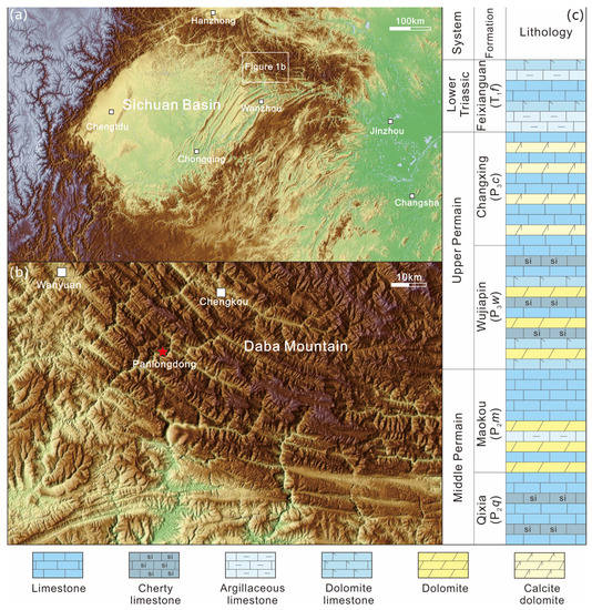
Figure 1.
Regional geological background map. (a) Rendered map of Sichuan Basin topography; (b) rendered map of study area topography; (c) main stratigraphic column of the study area.
The study area belongs to the Daba Mountains arc structural belt, where three major rock types, including micritic limestone, dolomitic limestone, and calcite limestone, are developed to varying degrees and have undergone complex tectonic movements [21]. The study area has a crystalline basement that formed during the Archean era, and it has been overlain by sedimentary cover layers since the Sinian (Ediacaran) period. Due to the compression associated with the Qinling orogenic belt [22], thrust faults have developed in the study area, and the deep structural deformation has been controlled by the subduction of the Yangtze Plate from south to north [11]. During the Jurassic period, intracontinental orogeny led to the formation of the Daba Mountains, with compressive stress diffusing from north to south [21,23]. The deformation zone in front of the Daba Mountains exhibits clear horizontal zoning and distinct layering in the vertical direction, influenced by complex tectonic movements. The formation of karst landforms in the study area has primarily been influenced by tectonic activities since the Cretaceous period. Since that time, the orogeny has extended from north to south [11], resulting in significant deformation of the sedimentary cover and the establishment of the current Daba Mountains structural style [24].
2.2. Terrain and Climate Characteristics
The study area is characterized by typical mountainous landforms (Figure 1b), with undulating mountain peaks, well-developed river systems, and overall developed karst landforms [21]. There are many streams, and the hydrographic net is mainly composed of two major river systems, including the Han River and Jialing River systems. The study area has a warm climate and belongs to the subtropical monsoon climate zone [25]. The average annual precipitation is 1194.6 mm and the average annual temperature is 14.7 °C [26]. Due to its mild climate, well-developed vegetation, good ecological environment, and abundant biological resources, it constitutes a good mountain ecosystem [21].
2.3. Stratigraphic Characteristics
Silurian to Quaternary strata are exposed in the study area, including clastic rocks and carbonate rocks. The Lower Silurian Xintan Formation is dominated by grayish green and chartreuse shale and sandy shale, with a small amount of sandstone siltstone and rich in graptolite fossils. The Xiaoheba Formation is mainly composed of gray–yellow sandstone and siltstone, mixed with gray and yellow shale. The unconformity surface with bauxite developed at the bottom of Permian system. The unconformity surface is overlain by the Liangshan Formation, where black shale, carbonaceous shale, and gray–white clay rock mixed with siltstone and coal seams have developed. The Middle Permian consists of the Qixia and Maokou formations. The Qixia Formation is composed of nodular microcrystalline limestone, massive limestone, and muddy microcrystalline limestone containing flint bands. The thick upper gray layer of the Maokou Formation contains chert nodules, massive biological limestone, and limestone, whereas the lower part is interbedded with dolomitic limestone, argillaceous limestone, and limestone. The Wujiaping Formation of the Upper Permian (Figure 1c) is mainly composed of thick-layered gray and dark gray biotic limestone, dolomitic limestone, biotic reef limestone, and dolomite with siliceous and chert bands. The Changxing Formation of the Upper Permian (Figure 1c) is characterized by the development of gray and dark gray intermediate massive limestone, calcareous dolomite, and the production of fusulinid fossils. A karst landform has developed in the research area, and the Panlongdong karst cave has mainly developed in the carbonate rocks of the Permian Wujiaping and Changxing formations.
3. Methods
3.1. Outcrop Geological Investigation
An outcrop geological survey is the fundamental work of this study. Firstly, a detailed investigation was conducted on the morphology, extension direction, and geological structure of the Panlongdong karst cave. Secondly, the geological characteristics of the stratum where the karst cave is located were investigated, including the occurrence state of the geological structure, its age and contact relationship with the surrounding geological bodies, the lithologic combination and its change, and the petrology characteristics, structural characteristics, and structural characteristics of various rocks, etc. The morphology and occurrence of faults and joints in the study area were also investigated. At the same time, samples of surrounding rock were taken, cut, and ground into thin slices, and identified under a microscope. Microscopic corrosion phenomena were recorded using high-definition cameras, each using two modes of plane-polarized light and cross-polarized light.
3.2. 14C Isotope Dating
Karst sediments such as travertine (Figure 2a,b) and stalactite (Figure 2c) have developed in the Panlongdong karst cave. 14C dating is used for stalactite. Stalactite samples (PLD01) were collected from the middle cave layer of the Panlongdong karst cave (Figure 2c, geographical coordinates 31°45’36” N and 108°27’41” E, and elevation of the sampling point 876 m). The stalactite developed in the Wujiaping Formation of the Upper Permian. It is a thick, dark gray bioclastic limestone containing chert nodules. Columnar sample PLD01 is 99.7 cm high and 10~20 cm in diameter. The 14C dating of stalactite sample PLD01 was completed in the BATE Laboratory.
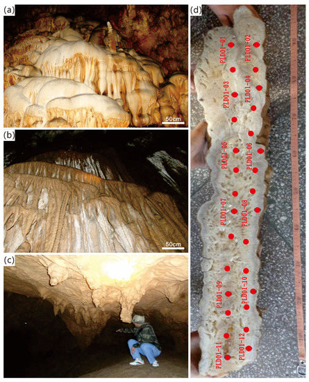
Figure 2.
Stalactite and sampling analysis point diagram. (a) Travertine and stalactite on the wall of the Panlongdong cave; (b) travertine and stalactite on the wall of the Panlongdong karst cave; (c) PLD01 sampling position; (d) 14C and carbon oxygen isotope sampling analysis points of PLD01.
The development of 14C dating technology is very mature and was applied early in the field of archaeology [27] and later extended to geology, with an effective dating range of (0.02–5.0) × 104 a [27], which is widely used in Quaternary geological research. The experimental technology of using carbon’s own radioactive decay characteristics for dating is mature and widely recognized by geologists. Assuming that the radioactive activity concentration in the sample is N0 (corrected using modern carbon standard activity concentration) and the radioactive activity concentration of the sample after t years is Nt, Nt = N0e−λ14t [28]. Among them, λ14 is the decay constant of 14C. The 14C dating of the stalactite measured 7 data points. The distribution of sample points is shown in Figure 2d.
3.3. C and O Isotope Analysis
The stalactite sample (PLD01) was simultaneously analyzed for carbon and oxygen isotope analysis. First, the polished stalactite sample was washed with pure water and placed in a ventilated place for natural air drying. Then, the stalactite was placed on a clean workbench and stalactite powder was drilled from the top to the bottom with a tooth drill (diameter of 0.5 mm). A total of 29 analysis points were drilled. The sampling points are shown in Figure 2d. In order to prevent mutual pollution between samples, the drill bit was cleaned with dilute nitric acid and pure water every time after a sample was collected, and a vacuum cleaner was used to absorb the remaining powder from the stalactite profile before carrying out the next sampling work. Finally, the sample was tested on the machine.
The sample was ground to within 200 mesh without pollution, and the amount of sample was determined by acid test for the determination of the carbon–oxygen isotope ratio. Before the test, 1 g sample was placed in a weighing bottle and placed in an oven at a temperature of 100 °C for 4 h to remove moisture. The sample was continuously titrated using the phosphoric acid method. During the test, microgram samples were placed in the headspace bottle, the lid was tightened, the temperature was kept at 25 °C, and the air in the headspace bottle was purged with high-purity helium gas for 10 min. After the whole batch of samples was purged, 10–12 drops of phosphoric acid were added systematically. After 20 h of reaction, the determination started. A constant temperature of 25 °C was maintained in the headspace bottle during testing. The sample standard deviation method was used to correct the sample data. The standard samples used were GBW04405, M1, M2, and PRM2, and all carbon and oxygen isotope composition data were converted into VPDB values.
In this study, oxygen and carbon isotope samples were collected and tested in the State Key Laboratory of Oil and Gas Reservoir Geology and Exploitation of Chengdu University of Technology and the Minerals-ALS Chemex, respectively. The test instrument was an isotope mass spectrometer MAT-253. The test results all refer to the VPDB standard, and the sample analysis error is ≤ 0.06‰.
4. Results
4.1. Karst Cave Morphology
Karst caves have developed in the study area, located from both sides of the river to the upper part of the mountains, with an altitude range of 300–1500 m and showing stratified features. The entrances to the karst caves are beaded, cracked, tubular, halls, galleries, etc., with varying sizes of height and width (or diameter) generally less than 10 m. The length of the cave is mostly 5–40 m. Horizontal plane and cracks have developed, and most of them are dry and water flows out after rainstorms. The Panlongdong karst cave is the largest and most typical karst cave in the study area.
The Panlongdong karst cave is located in the anticlinal axis. The elevation of the bottom entrance is 869 m. Surrounding rock strata are P3w and P3c. The cave is divided into upper, middle, and lower layers, and a pipeline system has developed. The bottom has an underground river outflow, and the middle main hole is about 80 m long, nearly 40 m wide, more than 10 m high, and has an area of about 20,000 m2. The main directional trend of the karst cave is in the northwest–southeast direction, and the plane is distributed in an “S” shape. The plan of the Panlongdong karst cave is shown in Figure 3a. In the longitudinal section (Figure 3b), large-scale karst landforms such as stalagmites, stone columns, stalactites, and stone flowers can be seen, recording the evolutionary history of the paleoclimate and paleoenvironment in the study area. They have various forms, such as flowers, cones, linear shapes, and exquisite and small stone flowers and ladders.
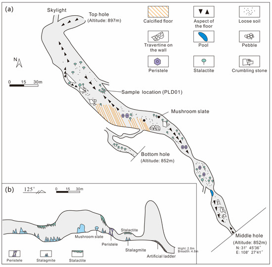
Figure 3.
Plan (a) and section (b) of the Panlongdong karst cave.
4.2. Petrology Characteristics
The interior of the Panlongdong karst cave is irregularly shaped, with a large number of calcareous deposits that have developed on the rock walls, forming a waterfall-like structure (Figure 2a,b). There are many stalagmites and stalactites in the cave (Figure 2c). The entire interior of the cave is covered with karst calcium, and its original rocks are from the Permian Wujiaping and Changxing formations (Figure 4a–c).
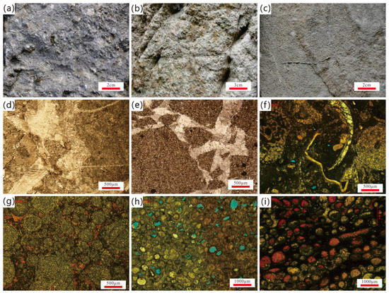
Figure 4.
Macroscopic and microscopic photos of rocks in the Panlongdong karst cave. (a) Bioclastic limestone outside the Panlongdong karst cave; (b) oolitic and pisolite dolomitic limestone outside the Panlongdong karst cave; (c) oolitic limestone with needle-shaped dissolution pores outside the Panlongdong karst cave; (d) argillaceous microcrystalline limestone, calcite filling crack/solution crack, plane-polarized light; (e) local breccia-like structure of dolomite veins, plane-polarized light in the Panlongdong karst cave and Wujiaping Formation; (f) reef limestone (reef-building organisms are sponges, crinoid stems, ostracodes, etc.) in the Panlongdong karst cave and Changxing Formation; (g) clastic dolomite with calcite cementation among the clasts in the Panlongdong karst cave and Changxing Formation; (h) fine-grained oolitic dolomite with developed moldic pores and intergranular dissolution pores in the Panlongdong karst cave and Changxing Formation; (i) fine-grained oolitic sand–clastic dolomite with dissolved pores in grains and mold holes that were later cemented by calcite in the Panlongdong karst cave and Changxing Formation.
Clastic rock and carbonate rock have developed in the Wujiaping Formation (P3w) of the Permian. The carbonate rocks are mainly crystalline limestone, often containing bioclasts. The grains are mainly silicates and microcrystals (Figure 4e), and a small number are silicates and fine crystalline dolomites (Figure 4d). In addition, argillaceous siltstone and dolomitic siliceous rocks have also developed, often in lamellar form, with a few cracks and locally developed quartz veins.
The Upper Permian Changxing Formation (P3c) is mainly composed of limestone, encompassing various types, such as micritic limestone, dolomitic limestone, oolitic limestone, etc. (Figure 4g–i), some of which contain bioclasts (Figure 4f). Dissolution fractures and a few microfractures have developed and filled with calcite in a later period. The intergranular dissolution pores are the most developed (Figure 4g,i), and some oolites have completely dissolved to form moldic pores (Figure 4h). A small amount of carbonaceous siliceous slate and fine-grained lithic quartz sandstone has also developed in the Changxing Formation in the study area.
4.3. Stalactite Chronology and C, O Isotopes
This study obtained a total of 7 14C dates (Table 1). Among them, the oldest age was 43,500 a.B.P (PLD01-11), and the remaining ages from old to new were 38,330 ± 420, 29,500 ± 190, 13,340 ± 50, 10,690 ± 40, 9650 ± 40, and 6420 ± 30 a.B.P. This means that stalactite experienced a growth cycle from at least 43,500 a.B.P to 6420 ± 30 a.B.P.

Table 1.
Carbon and oxygen isotopes and 14C age of stalactite.
According to the results of C and O isotopes (Table 1), the range of carbon isotope variation was from −11.786‰ to −5.234‰, with an average of −8.147‰. The variation range of oxygen isotopes was from −10.340 to −8.111‰, with an average of −9.477‰. The range of oxygen isotope values was similar to that of carbon isotopes, with values above −10‰ being the main body (from −9.965‰ to −8.111‰), with an average of −9.147‰, accounting for 69%. The other values were between −10‰ and −10.5‰, with a relatively small range of variation, averaging −10.210‰ and accounting for 31%.
5. Discussion
5.1. Impact of Sedimentary Characteristics
5.1.1. Microscopic Dissolution
Microscopic dissolution phenomena can reflect the intensity and direction of karst processes, but the microscopic manifestations of karst processes are often ignored. Thin-section identification indicated that the micro dissolution process is relatively developed in the study area. Due to fluid activity, micro dissolution pores and fractures are often filled with calcium (Figure 4a,b,g,i). The dissolution of bioclasts (selective dissolution of bivalves and echinoderm) was also developed (Figure 4f). In addition, it can be seen that the residual medium to fine crystal calcite was filled between the ooids (Figure 4g), and the moldic pores of some ooids were all filled with calcite (Figure 4i). There were also some moldic pores that were not filled (Figure 4h).
After compaction, consolidation, and diagenesis, the original unstable aragonite, high-magnesium calcite, and other carbonate sediments in the geological history were transformed into the most stable low-magnesium calcite [29,30]. The karst caves, crevices, and pores observed now have mostly formed on the rocks composed of low-magnesium calcite [31]. In addition, the structure of carbonate rocks plays an important role in controlling the development of karst. Granular limestone is the limestone most prone to karstification, which is related to its abundant intergranular and microcrystalline fractures that provide infiltration and circulation channels for corrosive water. On the other hand, although karst is common in microcrystalline limestone, the overall degree of karst development in microcrystalline limestone is weaker than that in granular limestone, and compaction joints, sutures, and structural cracks have become the main manifestations of karst.
The development of karst landforms is controlled by factors such as the chemical composition, layer thickness, and rock structure of carbonate rocks [29,32]. In some cases, the influence of the carbonate rock structure is much greater than its chemical composition [30,33]. Outcrop geological surveys have shown that rock types and distribution are important factors in karst development. Areas with a single exposure of thick and massive limestone exhibit karst distributed in patches. Moreover, the layered thickness of rocks has a significant impact on the scale of karst caves, and karst processes are strongly developed in pure, thick limestone layers. For limestone with different thicknesses in the same area, the strength of karst development varies greatly. The structures of rock play an important role in the development of karst, which was mainly manifested in limestone with oolitic, granular, and bioclastic structures in the study area, where the intensity of karst development is the strongest.
5.1.2. Sedimentary Environment and Dissolution
The sedimentary environment is the fundamental condition for rock formation, and the development of karst landforms is also closely related to sedimentary bodies [11]. The comparison of sedimentary facies between some wells and outcrops around the study area shows (Figure 5) that the original rock of Panlongdong is from the Permian reef sedimentary body, which belongs to the carbonate platform margin sedimentation as a whole. Outcrop surveys indicated that some reefs have experienced dolomitization, with bioclastic dolomite having developed at the top. Sponges, algae, and various other organisms, such as corals and bryozoans, constitute the primary reef-building organisms within the Changxing Formation. A reef is composed of a reef base, reef core, and reef cover. The reef base is developed with light gray, thick-layered, block-shaped bioclastic limestone and dark gray, medium-layered micrite limestone, with a thickness of 62.3 m. The reef core is composed of skeletal reef limestone and cemented reef limestone, with a thickness of 99.5 m. The reef cover dolomite is rich in asphalt, and the content of reef-building organisms is 20–50%.
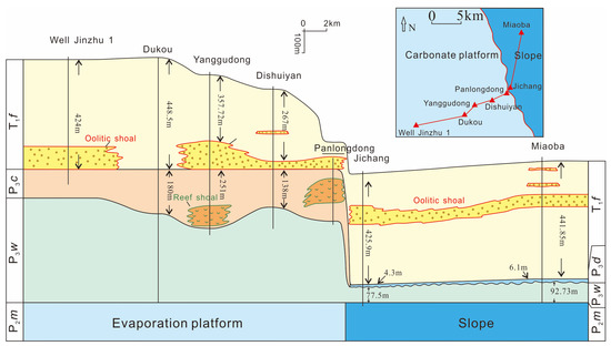
Figure 5.
Sedimentary facies comparison.
The thickness of the Panlongdong reef is relatively large and stable (55–276 m), with good rock properties (average porosity ranging from 6.31% to 11.86%, average 8.24%, and permeability ranging from 0.0267 to 0.0642 × 10⁻³ μm2, average 0.0466 × 10⁻³ μm2) [34]. The limestone with strong karst development is composed of biogenic debris and an oolitic structure in the shallow beach facies of the platform edge, located in the high-energy wave action zone under the tide, and is a seawater environment above the oxidation interface, with normal salinity and water depth ranging from a few meters to tens of meters. Under the influence of tides and waves, mud grains and small grains in the sediments were eliminated and washed away, and the remaining larger particles, such as biologenic debris, ooids, and internal debris, are in the form of grains supported by accumulation. After the supersaturated calcium carbonate solution precipitated in the particle gap, a granular limestone with crystalline cementation formed. The most significant characteristic of this rock in the karst research is the development of intergranular cracks and microcrystalline cracks, which provide seepage channels for dissolution water and very favorable conditions for accelerating the occurrence and development of karst.
5.2. Impact of Geologic Structures
5.2.1. Fold
Tectonic movement has led to the formation of various geologic structures. The study area is located at the southern margin of the Daba Mountains structural belt, which has complex geological conditions [21,22]. Many geologic structures, such as folds, faults, and joints, have developed, which have a significant impact on the development of karstification.
The folds in the study area are parallel in a northwest-to-southeast direction (NW–SE), exhibiting the characteristics of the Daba Mountains arc structure [11]. The entire research area is a continuous fold profile, with numerous folds (Table 2) and distinct features. The outcrop survey showed that there is a total of 34 folds in the study area, with almost all types of folds exposed, with the main folds being tight folds. There are numerous smaller and outcrop-level folds (Figure 6a,b), as well as larger-scale folds. There are eight well-preserved large-scale and mesoscale folds in the study area, with scales ranging from 1.5 to 3.5 km in width, making them the main fold structures in the study area.

Table 2.
Morphological classification and statistics of main folds in the study area.
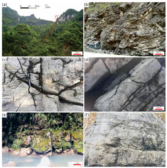
Figure 6.
Geologic structures of the study area; (a) Panlongdong fault and fold; (b) small folds on the outcrop; (c) X-conjugate joint; (d) joints; (e) cracks and flowing water; (f) erosion phenomenon on the surface of limestone outcrops.
Folds can lead to the formation of interlayer and layer fractures, and continuous dissolution ultimately leads to the formation of caves [11]. For example, anticlinal folds form saddle-shaped tensile fractures at the turning end of the axis, and interlayer fractures that stretch upwards at the axis of the syncline often become favorable sites for cave development [24]. The Panlongdong karst cave has developed in the axis of the Panlongdong anticline, with relatively well-developed small folds, faults, and joints. Previous research has shown that the tendency towards soluble rocks can lead to cave development reaching deeper depths [35]. The directional arrangement of surface sinkholes, karst funnels, and other structures is controlled by the direction of karst development. Karst water channels are typically provided by existing cracks, joints, and bedding planes [36,37]. With the retreat and further dissolution of karst channel walls, most of the karst water will eventually only pass through a few channels [3,38]. The degree of development of carbonate rock joints directly controls the formation of karst landforms [39]. Mountains continuously collapse and shrink or form cliffs affected by the erosion of water, forming colluvium at the foot of mountains or cliffs [38]. Due to seasonal precipitation, surface runoff is sometimes sufficient, and over time, the colluvium is transported by surface water, making karst landforms stand out. The southern part of the Daba Mountains belongs to a thrust fold, accompanied by detachment folding, resulting in the development of transverse tensile fractures. This has also led to the development of underground rivers that run vertically or diagonally through the strata in a northeast direction, such as the underground rivers in the Panlongdong karst cave.
5.2.2. Fault and Joint
The distribution of faults in the study area is complex, with activity intensity gradually decreasing from east to west, and it is densely distributed in the eastern and central regions of the study area, whereas there is no exposure on the surface of faults in the western region. The properties of the main fault structures in the study area are shown in Table 3. The closest fault to Panlongdong is the Panlongdong fault (F4), which is a thrust type (Figure 6a). It is located on the southwest side of the Panlongdong anticline, with a strike length of about 18 km, a tendency angle of 73°, and a dip angle of 67°.

Table 3.
Details of main faults in the study area.
In addition, this study explored the stages of structural deformation through the development of joints. In total, 10 joints were measured, and the basic characteristics, stress angle characteristics, and developmental stages of joint development were clarified (Table 4). The joints in the study area are mainly X-conjugate joints (Figure 6c,d), which are mainly developed in limestone, dolomite limestone, and marl. Due to the small displacement of the joint, no scratches were found on the joint surface. Most of the joints are not filled, with only a small number of joints having developed quartz veins. In the six measured joints, the stress σ1 (az/pl) was 45°/12°, 35°/2°, 71°/11°, 21°/3°, and NE–SW. Based on the occurrence and intersection relationship of joint development, it is believed that the tectonic stress causing joint development in the study area is from the same period.

Table 4.
Measured joint statistics and stress field inversion results.
Among the four typical thrust joints measured in the study area (Table 4), there were two left lateral joints. Joints have mainly developed in biogenic limestone and flint strip limestone. The joint surface scratches are relatively developed (three developed areas), with occurrences of ∠55°SW, ∠71°SW, and ∠49°NE. The outcrop characteristics indicated that there were obvious cut quartz veins visible at two joints, showing the tectonic stress effects of two stages. The other two joints exhibited characteristics of traction folding and no filling, and based on the traction attitude, this is believed to be the result of the action of tectonic stress in three stages.
Faults and fractures are also important factors promoting karst development [10], especially in sedimentary bodies with extremely poor original permeability within the platform, which is crucial for promoting karst processes [10,20]. The fault itself, which communicates to the deep, is a good channel for atmospheric fresh water, promoting the infiltration and dissolution of atmospheric fresh water from the surface to deeper strata through the fault [11,40]. Fractures usually develop near the fault and at the top of the associated anticline of the fault. Previous studies have found that the top of an anticline typically develops tension fractures and high-angle shear fractures that are nearly perpendicular to the bedding plane [10,11], whereas the bottom of a fold typically develops tension fractures that are nearly parallel to the bedding plane and a small number of medium-angle shear fractures. The vicinity of thrust faults is usually a favorable location for the development of high-angle fractures. The intricate geological conditions and dynamic tectonic activities in the research area have facilitated the proliferation of faults and fractures. The occurrence of rock fissures (Figure 6e) and surface erosion (Figure 6f) further augments the expansion of karst conduits, establishing a pivotal basis for the genesis of karst caves.
5.2.3. The Relationship between the Direction of Regional Tectonic Trend and Karst Caves
The Daba Mountains underwent formation through intracontinental orogeny during the Jurassic period [22], with compressive forces propagating from the northeast to the southwest. The influence of this detachment layer has resulted in the development of a spatial three-dimensional anisotropy in the front zone of the Daba Mountains, characterized by structural deformation [11]. Subsequently, during the Cretaceous period, a southward movement persisted [24], leading to the deformation of the caprock in the study area and the cessation of sedimentation [21,23]. The profound structural characteristics further suggest the northward subduction of the Yangtze block [23].
The intersecting occurrence of two tectonic fractures is commonly observed within the Wujiaping Formation of Panlongdong. This signifies the superposition of two distinct stages of tectonic activity within the Permian system. Taking into account the occurrence period and mechanical properties, and integrating the stress analysis outcomes of the measured section’s joints and folds, we can delineate these stages as follows: The initial stage entailed compression in the northeast–southwest direction, whereas the subsequent stage involved shear in the southeast–northwest direction. By examining the relationship between the development of karst caves in the study area and the structural trends illustrated in Figure 7, it becomes evident that shear action in the southeast–northwest direction constitutes a pivotal factor in the formation of karst caves. The karst caves in the research area exhibit overall characteristics characterized by their alignment with the rock layers, presenting a complex and multi-faceted karst cave structure influenced by joints and fissures. Moreover, the presence of numerous underground rivers is retained. Due to the multi-tiered nature of karst cave development, frequently clinging to mountainsides, the caves showcase a variety of waterfalls at different scales both within the cave and at their entrances.
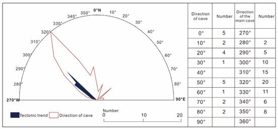
Figure 7.
Rose diagram of karst caves and structural trends.
5.3. Impact of Paleoclimate
5.3.1. Stalactite Growth Rate
Paleoclimate information is preserved in stalactite. The characteristics of stalactite and 14C isotope dating results show that the lighter-colored part of PLD01 in the Panlongdong karst cave had a relatively fast growth rate, which corresponds to the sedimentary characteristics. According to the data, the deposition rate and color change of stalactite at different stages were as follows: between 43.5 ka.B.P. and 13.3 ka.B.P. the deposition rate was slow and the color of stalactite gradually changes from white to gray–white. From 13.3 ka.B.P. to 10.7 ka.B.P., the sedimentation rate was the slowest and the color of the karst stalactite is the darkest, mainly gray–black and gray. Between 9.7 ka.B.P. and 6.4 ka.B.P., the sedimentation rate was the fastest and the color of karst stalactite is gray. The different characteristics above reflect the different climate at that time. The gray stalactite reflects the rapid deposition rate and humid climate; the relatively dark-color stalactite reflects the slow deposition process and dry climate.
Seven depositional cycles have developed on the Panlongdong karst cave stalactite (PLD01), and their specific characteristics are as follows.
The first depositional cycle: composed of grayish white, brown, weakly corrugated calcite, subdivided into three sub cycles, 15.2 cm thick.
The second depositional cycle: composed of weakly wavy, yellowish white and yellowish brown calcite, 16.9 cm thick.
The third depositional cycle: calcite laminae (yellow–white, gray–white), 7.2 cm thick.
The fourth depositional cycle: calcite rhythmic laminae, mainly brown–yellow and gray–white, 11.5 cm thick.
The fifth depositional cycle: recrystallized calcite lamina (gray–white and white), 12.5 cm thick.
The sixth depositional cycle: composed of grayish–yellow, white, and grayish–white calcite, 12.8 cm thick.
The seventh depositional cycle: calcite is mainly yellowish brown, grayish yellow–white, and grayish white, 23.6 cm thick.
Based on the growth length and age value of stalactite in each sedimentary cycle, the PLD01 stalactite growth rate curve (Figure 8) was drawn. It can be seen that the production rate of stalactite was not stable during the formation process, showing characteristics of fast and slow, which demonstrates a significant relationship with the geological conditions, paleoclimatic conditions, hydrological conditions, etc., during the formation of the stalactite.
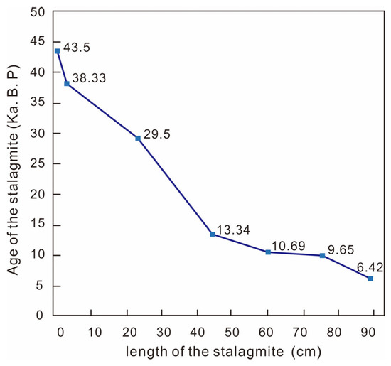
Figure 8.
Growth rate of stalactite.
5.3.2. Paleoclimate Evolution
The growth and development of stalactite are related to the cave structure, surface vegetation, hydrology, and climate conditions [41]. The development of stalactite in karst caves can be linked to the four spheres of the earth [42]. The changes in the external climate environment affected the deposition of stalactite [42,43]. Stalactite isotope research is one of the most important areas in the field of paleoclimate reconstruction [41,42,44]. The reconstruction of paleoclimate with stalactite isotopes as the research object is widely used in geological research [42]. The large amount of water vapor formed by seawater evaporation is transported by monsoons from the ocean region to high-latitude and inland areas, and through atmospheric circulation, precipitation is formed in inland areas. Surface precipitation provides an important source of replenishment for groundwater. Equilibrium fractionation of surface water, groundwater, and karst water in stalactite was recorded in δ18O [43]. In this process, stalactite grows and develops. Its formation includes two processes: dissolution and deposition [41]. The chemical equation is:
Dissolution process: CaCO3 (bedrock) + H2O (percolating water) + CO2 (soil) → HCO3− + Ca2+.
Deposition process: HCO3− + Ca2+ → CaCO3 (sediments) +H2O (cave dripping) + CO2.
Based on the chemical reaction process of stalactite dissolution and deposition, the source of the O element includes three parts, namely, bedrock CaCO3, permeable water H2O, and soil CO2 [43]. Since the bedrock CaCO3 has nothing to do with climate change, its contribution to stalactite δ18O is small. The exchange of soil CO2 and cave drip oxygen atoms is in equilibrium, and the seepage water is mainly from atmospheric precipitation δ18O changes, which play a decisive role [41]. The external climate and environment change form an infiltration solution in the form of rainfall, and the final climate information is sealed in the stalactite. In addition to oxygen isotopes, carbon isotopes continuously migrate and transform between the atmosphere, biosphere, pedosphere, and karst sphere, and undergo complex chemical and hydrological processes [45]. They are generally used as an auxiliary indicator in the field of paleoclimate research [43,44].
The variation of δ13C in stalactites is mainly related to two factors, including δ13C in CO2 in overburden soil of caves and vegetation types with different photosynthesis [42]. Therefore, the change in δ13C in stalactite can be used to study the process of paleoclimate change and paleo-vegetation replacement. The C and O show (Figure 9a) that the distribution of stable isotopes for C and O is negative, indicating that the hydrological environment tended to be closed at that time, with a dry and hot climate and high temperature and salinity. There have been no deposits in the study area since the Cretaceous, only Quaternary deposits. The uplift of carbonate strata is the basis for the development of karst landform. Therefore, the influence of crustal movement and paleoclimate change since the Late Cretaceous is extremely important. Due to the lack of sedimentary records, only stalactite has preserved paleoclimate information in karst areas. The distribution characteristics of carbon and oxygen isotopes combined with the growth process of stalactite can be divided into six stages (Figure 9b). Isotope analysis show that there have been about six cold and warm changes in Northeast Sichuan since 43.5 ka.B.P. The total average value of δ18O is −9.48‰ (representing the boundary point between cold and warm).
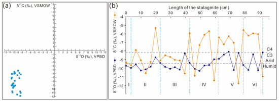
Figure 9.
Carbon and oxygen isotope relationship diagram (a) and curve (b).
For Stage I, between 43.5 ka.B.P. and 38.3 ka.B.P., the average δ18O value was −9.85‰ and the average δ13C value was −9.52‰.
For Stage II, between 38.3 ka.B.P. and 29.5 ka.B.P., the average δ18O value was −9.68‰ and the average δ13C value was −8.51‰.
In stages I and II, carbon and oxygen isotopes were both negative compared to the average, with a warm and humid climate and lush C3 plants.
For Stage III, between 29.5 ka.B.P. and 13.3 ka.B.P., the average δ18O value was −9.61‰ and the average δ13C value was −8.64‰. At this stage, oxygen isotopes were higher than the overall average and lower than the first two stages, indicating a decrease in rainfall, whereas vegetation changes were slightly delayed, with C3 plants still dominant. The overall climate tended to be dry and was in a slightly warm and humid stage.
For Stage IV, between 13.3 ka.B.P. and 10.7 ka.B.P., the average δ18O value was −9.60‰ and the average δ13C value was −7.95‰. The average oxygen isotope value was negative, but later measurements were all positive, indicating a gradual decrease in rainfall and temperature, with vegetation mainly composed of C4 plants.
For Stage V, between 10.7 ka.B.P. and 9.7 ka.B.P., the average δ18O value was −8.93‰ and the average δ13C value was −7.54‰.
For Stage VI, between 9.7 ka.B.P. and 6.4 ka.B.P., the average δ18O value was −9.26‰ and the average of δ13C value was −7.25‰.
C and O isotopes were positive in stages V and VI. The climate was cold and dry, and C4 vegetation dominated. Stalactite records show that δ18O and δ13C were consistent in the study area. The results show that the paleoclimate in this area changed from cold and dry to semiarid and sub-humid in the early period to warm and wet in the middle and late periods. This environmental background had a profound impact on the development of karst in this period.
5.4. Formation Process of Panlongdong Karst Cave
Since the Cretaceous, the climate in the Daba Mountains has changed frequently, which has provided favorable conditions for the development of karst landforms [46]. The growth characteristics of stalactite show that since 43.5 ka.B.P., the deposition rate of calcite has been changing from fast to slow, highlighting the characteristics of microwave lamellae and recrystallized lamellae. The deposition thickness was also different, which is closely related to climatic conditions and hydrological conditions. From the Late Cretaceous to the end of the Eocene, the freshwater lake basin developed into an inland saline lake basin [22], and the climate was characterized by alternate dry and wet seasons and abundant rainfall [26]. The underground water system was developed and flows independently from various terrain highlands to surrounding lowlands, with strong hydrodynamic forces [21]. Since 43.5 ka.B.P., there have been significant climate changes in the research area, with six continuous changes in temperature and cold exacerbating the formation of karst landforms. Warm, humid, and cold and dry climate conditions have occurred repeatedly, and carbonate rocks have experienced varying degrees of karstification under the influence of climate.
During the cold and dry climate period, the earth’s surface was mainly composed of thin calcareous layers [41], with weak vegetation development. Above the water table, magnesium calcite and aragonite were dominant, with weak cementation. Due to the decrease in atmospheric precipitation, both surface water and groundwater were relatively scarce, and the physical erosion and chemical dissolution of carbonate rocks were relatively weak.
During the transition period from a cold and dry climate to a warm and humid climate, the surface calcium layer gradually thickened, with thin soil forming on the surface and vegetation gradually developing during this period. Due to the warming climate, the prevalence of monsoons brought more precipitation [25]. Aragonite and calcite were mainly above the water table, with weak cementation. Surface water and groundwater began to be enriched, physical erosion and chemical dissolution gradually increased, and karst gullies gradually appeared on the surface. The formation of karst gullies intensified the intensity of erosion, stone teeth and underground rivers gradually formed, and karst landforms were initially developed in this period.
During the warm and humid climate period, soil with calcareous red soil as the cover layer was basically formed, and calcareous red soil was relatively fertile, promoting the development of surface vegetation [21]. During this period, monsoons were prevalent, with a warm and humid climate and abundant atmospheric precipitation. The surface and underground water systems developed [25], and the intensity of physical erosion and chemical dissolution reached its maximum. The surface karst landform, underground river, karst cave, and other underground karst landforms were relatively developed, and the stalactite sedimentation rate was relatively fast in this period. Underground rivers and karst caves often collapsed to form karst breccia influenced by gravity. This period was a critical period for the formation of karst landforms in the study area.
The alternation of multiple cold and dry, and warm and humid climates led to a phased development of karst landforms in the study area. Overall, climate fluctuations provided a prerequisite for shaping surface landforms, and warm and humid climates were the key to the development of karst landforms in the study area.
The development of the Panlongdong karst cave has been carried out through four stages, as shown in Figure 10. Firstly, the reef carbonate rocks were the fundamental geological conditions for the development of the Panlongdong karst cave. The transformation of tectonic processes was a key factor in the formation of this cave, and the development of folds, faults, and joints provided conditions for atmospheric freshwater dissolution. The structural breakup and surface dissolution was the first stage of cave formation (Figure 10a). As the karst channel matured, fluid interaction further strengthened, secondary dissolution developed, and calcium karst precipitation began to form. Secondary cranny dissolution was the second stage (Figure 10b). Under the alternating influence of multiple cold and dry, and warm and humid climates, early karst caves further experienced selective dissolution, and the internal structural rock mass fell off under gravity to form a larger karst cave space (Figure 10c). Selective dissolution and detachment of rock mass was the third stage. The final sediment gradually developed, the underground karst landform gradually formed, and stalagmites and stalactites developed. In addition, the appearance of stone pillars demonstrates that the underground karst landform had entered a mature stage (Figure 10d). The sediment formation stage is the current stage, ultimately forming the present-day Panlongdong karst cave.
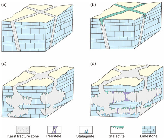
Figure 10.
Formation stages of the Panlongdong karst cave. (a) The first stage of structural breakup and surface dissolution; (b) the second stage of secondary cranny dissolution; (c) the third stage of selective dissolution and detachment of rock mass; (d) the fourth stage of karst sediment formation.
6. Conclusions
The presence of thick and massive limestone formations in the study area promotes the development of karst phenomena, with karst distributed in patches. Under the influence of tides and waves, finer sediment particles were eliminated and washed away, leaving behind larger particles such as biogenic debris, ooids, and internal debris, which accumulated to form grains supporting the karst structure.
The research highlights the importance of geological structures, including faults and joints, in providing pathways for the dissolution of atmospheric precipitation, further contributing to the formation of karst caves. Additionally, the sedimentation of biogenic reefs and carbonate rocks serves as a fundamental geological condition for the development of karst processes.
The spatiotemporal evolution of the Panlongdong karst cave has undergone four distinct stages, including structural breakup and surface dissolution, secondary cranny dissolution, selective dissolution, and detachment of rock mass and karst sediments formation.
Author Contributions
Conceptualization, D.M. and J.T.; methodology, J.L.; software, S.F. and Q.L.; validation, J.T.; formal analysis, Q.L. and J.L.; investigation, D.M. and J.L.; resources, D.M.; writing—original draft preparation, D.M.; writing—review and editing, J.L.; supervision, Q.L. All authors have read and agreed to the published version of the manuscript.
Funding
This research received no external funding.
Data Availability Statement
Not applicable.
Conflicts of Interest
The authors declare no conflict of interest.
References
- Deng, Y.H.; Wang, S.J.; Bai, X.Y.; Luo, G.J.; Wu, L.H.; Chen, F.; Wang, J.F.; Li, Q.; Li, C.J.; Yang, Y.J.; et al. Spatiotemporal dynamics of soil moisture in the karst areas of China based on reanalysis and observations data. J. Hydrol. 2020, 585, 124744. [Google Scholar] [CrossRef]
- Gutiérrez, F.; Parise, M.; De Waele, J.; Jourde, H. A review on natural and human-induced geohazards and impacts in karst. Earth-Sci. Rev. 2014, 138, 61–88. [Google Scholar] [CrossRef]
- Ford, D.; Williams, P.D. Karst Hydrogeology and Geomorphology; American Geophysical Union: Washington, DC, USA, 2007; p. 562. [Google Scholar]
- Billi, A.; Filippis, L.D.; Poncia, P.P.; Sella, P.; Faccenna, C. Hidden sinkholes and karst cavities in the travertine plateau of a highly-populated geothermal seismic territory (Tivoli, central Italy). Geomorphology 2016, 255, 63–80. [Google Scholar] [CrossRef]
- Ding, Y.; Ma, Z. Geological and geomorphic exploration and formation mechanism of the Shilin Geopark in Zecha, Gansu Province. Arab. J. Geosci. 2020, 13, 1013. [Google Scholar] [CrossRef]
- Navidtalab, A.; Moghim, G.M. Climate, lithology, and tectonics interaction in shaping a hazardous salt karst: A case from the middle–late Miocene (?) evaporite succession of NE Iran. Geomorphology 2020, 356, 107067. [Google Scholar] [CrossRef]
- Mosser, L.; Dubrule, O.; Blunt, M.J. Stochastic reconstruction of an oolitic limestone by generative adversarial networks. Transp. Porous Media 2018, 125, 81–103. [Google Scholar] [CrossRef]
- Wray, R. A global review of solutional weathering forms on quartz sandstones. Earth-Sci. Revi. 1997, 42, 137–160. [Google Scholar] [CrossRef]
- Moradi, S.; Kalantari, N.; Charchi, A. Geomorphology of karst features in the northeast of Khuzestan, Iran. Carbonates Evaporite 2018, 33, 107–121. [Google Scholar] [CrossRef]
- Silva, O.L.; Bezerra, F.H.R.; Maia, R.P.; Cazarin, C.L. Karst landforms revealed at various scales using LiDAR and UAV in semi-arid Brazil: Consideration on karstification processes and methodological constraints. Geomorphology 2017, 295, 611–630. [Google Scholar] [CrossRef]
- Liu, S.G.; Yang, Y.; Deng, B.; Zhong, Y.; Wen, L.; Sun, W.; Li, Z.W.; Jansa, L.; Li, J.X.; Song, J.M.; et al. Tectonic evolution of the Sichuan Basin, Southwest China. Earth-Sci. Rev. 2021, 213, 103470. [Google Scholar] [CrossRef]
- Wilson, J.P. Digital terrain modeling. Geomorphology 2012, 137, 107–121. [Google Scholar] [CrossRef]
- Grasmueck, M.; Moser, T.J.; Pelissier, M.A.; Pajchel, J.; Pomar, K. Diffraction signatures of fracture intersections. Interpretation 2015, 3, SF55–SF68. [Google Scholar] [CrossRef]
- Gosar, A.; Čeru, T. Search for an artificially buried karst cave entrance using ground penetrating radar: A successful case of locating the S-19 Cave in the Mt. Kanin massif (NW Slovenia). Int. J. Speleol. 2016, 45, 135–147. [Google Scholar] [CrossRef]
- Patel, P.P.; Sarkar, A. Terrain characterization using SRTM data. J. Indian Soc. Remote. 2010, 38, 11–24. [Google Scholar] [CrossRef]
- Choi, Y. A new algorithm to calculate weighted flow-accumulation from a DEM by considering surface and underground stormwater infrastructure. Environ. Modell. Softw. 2012, 30, 81–91. [Google Scholar] [CrossRef]
- Zhou, Q.; Zhu, A.X. The recent advancement in digital terrain analysis and modeling. Int. J. Geogr. Inf. Sci. 2013, 27, 1269–1271. [Google Scholar] [CrossRef]
- Hu, X.Q.; Shi, Z.J.; Tian, Y.M.; Wang, C.C. The restoration of karst ancient landform of the Maokou Formation in southeastern Sichuan basin. Geol. Bull. China 2014, 33, 874–882. [Google Scholar]
- Zhong, Y.; Yang, Y.M.; Wen, L.; Luo, B.; Xiao, D.; Li, M.L.; Chen, C.; Zhao, L.K.; Lu, F.F.; Tan, X.C. Reconstruction and petroleum geological significance of lithofacies paleogeography and paleokarst geomorphology of the Middle Permian Maokou Formation in northwestern Sichuan Basin, SW China. Petrol Explor. Dev. 2020, 48, 81–93. [Google Scholar] [CrossRef]
- Hao, Y.X.; Bell, R.; Hu, D.F.; Fan, R.; Wang, Y.H. Prediction of permian karst reservoirs in the yuanba gas field, northern sichuan basin, China. Mar. Petrol. Geo. 2023, 154, 106160. [Google Scholar] [CrossRef]
- Shi, X.H.; Yang, Z.; Dong, Y.P.; Qu, H.J.; Zhou, B.; Cheng, B. Geomorphic indices and longitudinal profile of the Daba Shan, northeastern Sichuan Basin: Evidence for the late Cenozoic eastward growth of the Tibetan Plateau. Geomorphology 2020, 353, 107031. [Google Scholar] [CrossRef]
- Hu, X.Z.; Zhang, Y.Q.; Li, Y.X.; Ma, S.X.; Li, J.P. Post-orogenic tectonic evolution of the Qinling belt, central China: Insights from a magnetostratigraphic study of a Cretaceous intra-mountain basin sedimentary succession. J. Asian Earth Sci. 2020, 202, 104496. [Google Scholar] [CrossRef]
- Miao, Z.S.; Pei, Y.W.; Su, N.; Sheng, S.Z.; Feng, B.; Jiang, H.; Liang, H.; Hong, H.T. Spatial and temporal evolution of the Sinian and its implications on petroleum exploration in the Sichuan Basin, China. J. Petrol. Sci. Eng. 2022, 210, 110036. [Google Scholar] [CrossRef]
- Sun, Z.M. Superimposed hydrocarbon accumulation through multi-source and multi-stage evolution in the Cambrian Xixiangchi Group of eastern Sichuan Basin: A case study of the Pingqiao gas-bearing anticline. Energy Geosci. 2022, 4, 131–142. [Google Scholar] [CrossRef]
- Yao, Y.H.; Cui, L.L. Vegetation Dynamics in the Qinling-Daba Mountains through Climate Warming with Land-Use Policy. Forests 2022, 13, 1361. [Google Scholar] [CrossRef]
- Zhao, F.; Zhang, J.Y.; Liu, S.Y.; Wang, Z.Y.; Wang, L.H.; Gu, H.T.; Li, W.L. Assessing the dividing line between warm temperate and subtropical zones based on the zonality discussion on multi-dimensional response of Net Primary Productivity to climate change in the Qinling-Daba Mountains. Acta Ecol. Sin. 2020, 41, 57–68. [Google Scholar]
- Lowe, J.J.; Walker, M.J.C. Reconstructing Quaternary Environments; Addison Wesley Longman: London, UK, 1997. [Google Scholar]
- Ye, Y.G.; Wang, X.E.; Diao, X.B. A preliminary study on the reliability of radiocarbon age from Shidao Island of Xisha Archipelago. Mar. Geol. Quat. Geol. 1987, 7, 121–130. [Google Scholar]
- Kollias, K.; Godelitsas, A.; Astilleros, J.M.; Ladas, S.; Lagoyannis, A.; Mavromoustakos, T. Dissolution and sorption mechanisms at the aluminosilicate and carbonate mineral-AMD (Acid Mine Drainage) interface. Appl. Geochem. 2021, 131, 105027. [Google Scholar] [CrossRef]
- Sun, F.N.; Hu, W.X.; Wu, H.G.; Fu, B.; Wang, X.L.; Tang, Y.; Cao, J.; Yang, S.C.; Hu, Z.Y. Two-stage mineral dissolution and precipitation related to organic matter degradation: Insights from in situ C–O isotopes of zoned carbonate cements. Mar. Petrol. Geol. 2021, 124, 104812. [Google Scholar] [CrossRef]
- Wang, Y.J.; Zhou, F.J.; Zhang, Y.; Wang, Y.C.; Su, H.; Dong, R.C.; Wang, Q.; Bai, H. Numerical studies and analysis on reaction characteristics of limestone and dolomite in carbonate matrix acidizing. Geoenergy Sci. Eng. 2023, 222, 211452. [Google Scholar] [CrossRef]
- Hu, A.P.; Shen, A.J.; Yang, H.X.; Zhang, J.; Wang, X.; Yang, L.; Meng, S.X. Dolomite genesis and reservoir-cap rock assemblage in carbonate-evaporite paragenesis system. Petrol. Explor. Dev. 2019, 46, 969–982. [Google Scholar] [CrossRef]
- Kirstein, J.; Hellevang, H.; Haile, B.G.; Gleixner, G.; Gaupp, R. Experimental determination of natural carbonate rock dissolution rates with a focus on temperature dependency. Geomorphology 2016, 261, 30–40. [Google Scholar] [CrossRef]
- Ma, D.Q.; Tian, J.C.; Lin, X.B.; Wen, L.; Xu, L. Differences and controlling factors of Changxing Formation reefs of the Permian in the Sichuan Basin. Oil Gas Geol. 2020, 41, 1176–1187. [Google Scholar]
- Addesso, R.; Gonzalez-Pimentel, J.L.; D’Angeli, I.M.; De Waele, J.; SaizJimenez, C.; Jurado, V.; Miller, A.Z.; Cubero, B.; Vigliotta, G.; Baldantoni, D. Microbial Community Characterizing Vermiculations from Karst Caves and Its Role in Their Formation. Microb. Ecol. 2021, 81, 884–896. [Google Scholar] [CrossRef] [PubMed]
- Moore, P.J.; Martin, J.B.; Screaton, E.J.; Neuhof, P.S. Conduit enlargement in an eogenetic karst aquifer. J. Hydrol. 2011, 393, 143–155. [Google Scholar] [CrossRef]
- Kan, H.; Urata, K.; Nagao, M.; Hori, N.; Fujita, K.; Yokoyama, Y.; Nakashima, Y.; Ohashi, T.; Goto, K.; Suzuki, A. Submerged karst landforms observed by multibeam bathymetric survey in Nagura Bay, Ishigaki Island, southwestern Japan. Geomorphology 2015, 229, 112–124. [Google Scholar] [CrossRef]
- Che, Z.Q.; Tan, X.C.; Deng, J.T.; Jin, M.D. The characteristics and controlling factors of facies-controlled coastal eogenetic karst: Insights from the Fourth Member of Neoproterozoic Dengying Formation, Central Sichuan Basin, China. Carbonates Evaporites 2019, 34, 1771–1783. [Google Scholar] [CrossRef]
- Gorbatikov, A.V.; Gabsatarova, I.P.; Rogozhin, E.A.; Stepanova, M.Y.; Kharazova, Y.V.; Sysolin, A.I.; Pogrebchenko, V.A. Refinement of the Deep Structure and Tectonic Movement Kinematics in the Area of the 2001 Salsk Earthquake Based on New Geophysical Data. Seism. Instrum. 2019, 55, 633–641. [Google Scholar] [CrossRef]
- Timothy, J.; Daniel, J.R.; Ronald, F.; Lawrence, M.; Henry, L.; Christophe, J.G. Darnault, Hydrogeologic and geomorphic processes in a karst landscape and seasonably-cold climate: Linking spatial distribution and morphometric dynamics of closed depressions to bedrock fractures in a wastewater spray irrigated agricultural and forest system located at the site of the Living Filter in Central Pennsylvania, United States. Agr. Water Manag. 2023, 279, 108170. [Google Scholar] [CrossRef]
- Dreybrodt, W.; Scholz, D. Climatic dependence of stable carbon and oxygen isotope signals recorded in speleothems: From soil water to speleothem calcite. Geochim. Cosmochim. Acta 2011, 75, 734–752. [Google Scholar] [CrossRef]
- Woo, K.S.; Ji, H.; Jo, K.; Yi, S.; Cheng, H.; Edwards, R.L.; Hong, G.H. Reconstruction of the Northeast Asian monsoon climate history for the past 400 years based on textural, carbon and oxygen isotope record of a stalagmite from Yongcheon lava tube cave, Jeju Island, Korea. Quatern. Int. 2015, 384, 37–51. [Google Scholar] [CrossRef]
- Fairchild, I.J.; Smith, C.L.; Baker, A.; Fuller, L.; Spötl, C.; Mattey, D. Modification and preservation of environmental signals in speleothems. Earth-Sci. Rev. 2006, 75, 105–153. [Google Scholar] [CrossRef]
- Sade, Z.; Hegyi, S.; Hansen, M.; Scholz, D. Itay Halevy, The effects of drip rate and geometry on the isotopic composition of speleothems: Evaluation with an advection-diffusion-reaction model. Geochim. Cosmochim. Acta 2022, 317, 409–432. [Google Scholar] [CrossRef]
- Mcdermott, F. Palaeo-climate reconstruction from stable isotope variations in speleothems: A review. Quat. Sci. Rev. 2004, 23, 901–918. [Google Scholar] [CrossRef]
- Zhou, H.Y.; Wang, Y. Speleothem Mg, Sr and Ba records during the MIS 5c-d, and implications for paleoclimate change in NE Sichuan, Central China. Chin. Sci. Bull. 2011, 56, 3445–3450. [Google Scholar] [CrossRef]
Disclaimer/Publisher’s Note: The statements, opinions and data contained in all publications are solely those of the individual author(s) and contributor(s) and not of MDPI and/or the editor(s). MDPI and/or the editor(s) disclaim responsibility for any injury to people or property resulting from any ideas, methods, instructions or products referred to in the content. |
© 2023 by the authors. Licensee MDPI, Basel, Switzerland. This article is an open access article distributed under the terms and conditions of the Creative Commons Attribution (CC BY) license (https://creativecommons.org/licenses/by/4.0/).