Abstract
The paper presents an innovated method for territorial zoning and its implementation in the territory of the Zdíkovský stream catchment area. The basis for projecting is ananthropo-ecological approach to the territory and the proposition of determining the new GES (geo-ecological units). Four essential territorial zones differing by anthropo-ecological burden and the degree of protection are suggested. A procedure for determining ecocritical lines (situations) in the territory, their regime, and possible solutions is suggested in the spirit of sustainability for future generations. The formulae and procedure for calculating the CES (coefficient of ecological stability) or ZSES (essential degrees of ecological stability), which divide the tested territory into appropriate zones, are also suggested. A comparison of zoning prior to 1989 and following was carried out, and it was proven that the significant presence of agricultural and forest subsystems in the territory with the extensive form of use resulted in the differentiation of the territory in terms of landscape character. The results point to the usability of the suggested method in the areas of planning, landscape development, protection, and territorial future development prognosis in terms of the natural potential on the local and superregional level.
1. Introduction
In general, territory, or the country landscape in our case, is economically usable; it is a complicated and hardly describable set of items and relations that are intertwined and form a specific production–economic–social system. Therefore, it is currently very important to carry out analysis and valuation of this system for many reasons. A crucial attribute calling for a fast solution for the above-mentioned issues is their positive solution, which is a condition for the preservation and sustainability of mankind on our planet. One of the significant areas requiring targeted research activities such as identification, analysis, valuation, and solution projection is the impact of human activity on natural phenomena and processes. The use of territorial production potential is also significant. With this feedback, society can re-valuate its behaviour and reduce negative effects on the environment.
The ecological optimization of a territory has two crucial levels, which are equal in terms of their significance and need; moreover, they are mutually conditioned. The first area may be called the area of economic use limited by the degree (intensity) and form. The actual basis of this area is substance–energy flows in the landscape, or in its relevant segment. With regard to two basic laws of thermodynamics concerning transformational changes of energy flows in landscapes, within landscape (territory) exploitation, it is necessary to ensure the balanced ration between inputs and outputs while eliminating or minimizing residual outputs. Respecting and mainly practical implementation of this approach in real economic practice is the basic sustainability axiom of both landscape and human activities implemented. The second area is in the issue of protecting and creating the environment, which is marked by mapping and valuating the landscape with the aim of identifying the ecologically significant places that have not been damaged by humans and need to be protected. Its function and content are based on the first area, with which it forms an integral unit with a specific dynamic and process character. The previous research activities of the authors [1] proved that complying with the principles of environmental protection and the presence of significant environmental segments in the territory positively influences the economic activities of business subjects, especially their economic results in the territory. This interrelation and condition between the economy and the environment ought to be an unwritten law and both areas ought to be included into the process of planning all the used territories with regard to their specific characteristics.
The authors of this paper build upon their previous research of this issue; above all, the intensity use and respecting the principles of balanced exploiting of the appropriate structures in the anthropo-ecological system (anthropogenic, anthropic and natural). Within the entire region of South Bohemia [2], it was proved that the natural potential must be respected whilst setting the intensity of using the production potential of the territory; it is differentiated in accordance with the natural, economic, and social characteristics of a particular territory. At the same time, it was statistically proven that both overuses, i.e., exceeding the natural territorial potential and underusing it are a negative phenomenon in terms of territorial sustainability. Both levels are crucially detrimental in terms of the whole society; moreover, they are chronically at loss and risky. This is documented by the outcomes of modelled territory presented in this paper as well.
2. Literature Research
Dealing with the problems of contemporary landscapes requires a combination of various perspectives and methods in order to propose innovative and adaptive directions to the future. A landscape is a complicated system [3] that cannot be understood by the analysis of its individual relations, rather only by a systemic and holistic approach based on the analysis of relations, processes, and principles. A landscape is an integrated set of ecosystems [4] which energetically communicate with each other, transmit information, and influence each other. In [5], a landscape is defined in accordance with the effects of natural landscape-forming processes. They also point out the fact that a natural landscape is nowadays limited to small areas of Earth’s surface in hardly accessible locations. Further, some authors divide a natural landscape into a zonal natural landscape, whose features and behaviour are determined by the laws of latitude striping, longitude gradation, and azonal landscapes formed by the influence of endogenous landscape-forming processes [6]. The landscape that is close to a natural landscape is marked by the prevalence of natural vegetation, which is nevertheless influenced by a human activity [7]. A cultural landscape, where the natural base merges with the landscape components directly created by a human society, was gradually formed by the alteration of a natural landscape [8].
A cultural landscape (degraded landscape) is a landscape with a degraded stability, and its natural conditions are negatively influenced by humans. In [9,10], the classification of cultural landscape is provided; there is a cultivated landscape, where natural species exist, but the landscape is cultivated for the purpose of production (forests, pastures); a farmed landscape, where the natural or cultivated enclaves are scattered among farmed areas; and a suburban landscape, which is a transition between a town and a free landscape and an urban landscape with dense development. In accordance with [10] and others, a landscape can be defined as a complex of geographically, functionally, and historically interconnected ecosystems (i.e., an organised land). While it is usually stated that a natural ecosystem is a homogenous system, in the case of a landscape ecosystem, it is heterogeneous in the sense that it is heterogeneous in at least one of its aspects (topography, use of territory, vegetation type, vegetation structure, etc.) [11]. Landscape ecology is a branch of ecology that uses the essential ecological knowledge about the flows of energy and properties in the ecosystems for the purpose of analysing and characterising the landscape [12]. Landscape ecology is therefore an interdisciplinary research branch that studies and predicts the formation, development, behaviour and space organisation of natural territorial units as holistic formations [4].
Modern landscape planning and management sees a landscape as a unit or system, the existence of which depends on natural, social, and economic conditions. The highest demand for projecting a landscape and landscape management is accepting landscape sustainability and preserving its biological diversity [13]. The subject of territorial ecological analysis is studying physical–biological relations governing various special units of the region and the gradual determination of their weight, i.e., the analysis of negative environmental parameters. The aim is to reveal and interpret the possibilities offered by nature and the limits of their use (e.g., ecological landscape stability is one of the limits) [14,15,16]. An ecosystem contains living organisms (plants, animals) in a particular place in an interaction with a non-living environment [14,17]. There are four essential interrelated processes in every ecosystem: energy flow, property circulation, management, and development, providing a formation of a dynamically balanced ecological system [18,19]. The main manifestation of ecological stability is an ecological balance that is a dynamic state of an ecological system, which is permanently maintained with a minor oscillation or where it spontaneously returns itself [20,21]. The opposite is an ecological instability, which is an inability of an ecological system to persist when it is externally influenced or the inability to return to the initial state [22].
One of the first persons dealing with a landscape function (in a contemporary concept) was Ludwig von Bertalanffy [23]. Based on the theory of “the circulation of properties and energy in ecosystems”, this principle became one of the essential ecological edifices [24]. The landscape function is therefore usually defined as the flows of energy and properties in an ecosystem [25,26]. Essentially, it is an interaction between its spatial properties, which can be imagined as the exchange of energy, properties, organisms, and information on a various hierarchical level. The interactions of an abiotic environment with a biotic environment are typical for every ecosystem, the results of which are energy material flows. A solar radiation is a main and one-way directed source of energy for all physical, chemical, and biological processes. The modern understanding of ecosystems was largely formed by the concepts of energy flow, food networks, and trophic levels (e.g., [27,28,29,30,31]. These ideas were later built upon by Elton [32], and he created an astrophic pyramid of organism abundance [33]. Lindeman [34] generalised this pyramid into a trophic form [35]. All of these authors attempted to understand the essential relations, and the biological community stumbled over two limiting factors. The first limit was the absence of instruments for measuring the inputs and outputs of organic matter for ecosystems and their economic quantification [36], while the other problem was the absence of a method for how to correctly place the organisms into discrete trophic levels for a specific analysed ecosystem [37,38]. These facts were a motivation for further research with the aim to quantify the flows of energy following on the trophic interactions. Building upon these research activities, new, and in a sense revolutionary, theories were formed. They pointed to the relation of natural ecosystems and organisms living in them, where regulation and energetic controls take place [39,40]. Odum [27] modified his study several times later. His ground-breaking eco-systemic study was motivated by the interest in testing Lotka’s maximum performance theorem and the related theory of the balance of energetic effectiveness [41,42].
A rather different view of energy cycles is provided by Patten [43]. Patten disproves the theory of considering only the property flow in a cycle, but not energy. The authors of the paper respect the possibility of separating property flows from energy flows. The conditionality of the two categories, i.e., the property flow and the energy flow in the territory (ecosystem) will be addressed in the following paper. The paper is focused on the measures resulting in decreasing the anthropic pressure on the landscape with the use of carrier media, such as soil-water, plant, and animal communities.
When designing sustainable landscape management systems, the only possible existential approach of mankind consists in respecting the anthropo-ecological landscape system. People are an inseparable part of the landscape system, not in a superior position. However, at the same time, through their interventions, they are the only living organisms that can intentionally, logically, and purposefully positively or negatively influence natural ecosystems in a fundamental and often irreversible way. For this purpose, substance–energy balance is necessary, expressing the degree of equilibrium in the area, which is the objective of every land-use system. The equilibrium state has a changeable nature and cannot be stabilized; rather, it is necessary to strive for its permanent nature.
Hypothesis 1:
Fostering the presence of agricultural and forest subsystems in a territory with extensive form creates prerequisites for increasing the environmental value of a landscape.
Hypothesis 2:
The reduction of the extent of the eco-crisis zones is accomplished by changing the landscape character as a result of fostering the stabilising elements in the landscape.
3. Materials and Methods
The suggested procedure is presented in one of the tested territories that were selected at the then Institute of Landscape Ecology of the Czechoslovak Academy of Science in the 1980s. It is the territory of the Zdíkovský stream catchment area, which has been monitored by the authors since the termination of the academy institute in Ceske Budejovice. The analytical works are financed from internal resources with minimisation in compliance with the means of research. The territory is selected by the authors due to both the long-term monitoring and especially clear, crucial, and practical proof of the suggested procedure of ecological optimization in the perspective of its positive impact on the sustainable use and protection of tested territory.
3.1. Essential Data on the Territory
The catchment area of the Zdíkovský stream (catchment area number of the Zdíkovský stream: 1-08-02-013, Total basin area: 17.46 km2, woodland-56%) passes in the cadastral territory of Branišov u Zdíkovce, Hrabice, Křesanov, Masákova Lhota, Nové Hutě, Paseka u Borových Lad, Zdíkov, Zdíkovec, Žírec. It is on the border of Vimperk highland and Sumava plains. The altitude of the basin is approximately 746 m above the sea level and the basin is approximately 5.83 km from Vimperk. The spring of Zdikov stream is about 3.5 km from the Zdikov community in Zdikov Forest with an altitude of 980 m above the sea level near Mount Hrb (1074 m above the sea level). This basin is significantly heterogeneous in terms of ecology; the axis of superregional bio-corridor passes through its southern part. In contrast, the northern part (Zdikovec) is under a strong civilisation pressure. It is a rugged highland with a mean altitude of 587 m and a mean slope of 7°10′. The prevailing height division is 200–400 m. The lowest altitude is 470 m and the highest is 1050 m. The territory is characterised as cool CH 7, which turns into mildly cool, humid territory on the way inside the territory. The period of full vegetation (average daily temperature above 10 °C) appears not sooner than at the beginning of June. The majority of soils on paragular substrate are oligotrophic and oligomesotrophic brown soils. Glazed brown earth to brown gleys are developed alongside the streams. There are signs of podsolization in high areas, and rankers were formed in places of abundant rubble.
From the perspective of biogeographical division of the Czech Republic [44], Zdíkov belongs to the zone of Central European deciduous forests, Hercynian sub-province. An important biogeographical divide passes through the area under consideration, specifically the border between the Šumava and Sušice bioregion. The Šumava bioregion was nearly unsettled for a long time, and in the Middle Ages, it long fulfilled the role of a border forest-like wood. A higher impact of human activities started to be seen in the 17th century, with the great boom of glassmaking. A significant part of original forests in the beech stage was then converted to spruce monocultures. However, relatively extensive stands with a natural tree composition are still preserved. Currently, however, mainly and especially the top parts are significantly damaged by emissions and blowdown. The settlement of Šumava has never been dense, especially in the area of central plains. After 1945, many settlements disappeared. Meadows and pastures prevailed in replacement vegetation, and there was only a low share of arable land. Nevertheless, many meadows and pastures were destroyed by land reclamation in the last century. Within the cadastral boundaries, the area under consideration is characterised by above-average forest cover. The occurrence of scattered woody vegetation, linear, flat, accompanying and riparian vegetation, is also above average in the area under consideration. Forest stands in the catchment area of the Zvíkovský stream are mostly commercial forests. Most grasslands outside the PLA had a cultural character until 1989; they were regularly fertilized and poor in species. Until 1998, there was also arable land, which was threatened by erosion and treated with pesticides.
However, many meadows and pastures were destroyed by land reclamation in the last century. Within the cadastral boundaries, the treated area is characterised by above-average forest cover. Scattered woody vegetation, linear, flat, accompanying and riparian, also occurs in an above-average amount in the treated area. The forest stands in the Zvíkovské stream basin are mostly economic forests. Until 1989, the majority of grasslands outside the PLA had a cultural character, were regularly fertilized, and were poor in species. Until 1998, there was also arable land at risk of erosion and treated with pesticides.
3.2. Theoretical Principle of Ecological Optimization
Designing sustainable systems of management is based on the assumption of the current state and assessment of the volume of inputs and expected outputs. It is thus a certain level of optimization of the current use of land without limiting its economic and scientific potential for future generations. In general, the priority is currently to address and reduce anthropic pressure on landscapes. This can be achieved by optimization of landscape structure: the structural side of ecological stabilization (optimal distribution of ecosystems in the landscape) and functional stabilization of agricultural land, i.e., the method of farming as such. The focus of the functional stabilization of agricultural land must therefore become the management in its matrix, i.e., on agricultural areas with agroecosystems.
In the first phase of the solution, an “analysis of landscape fragmentation from the perspective of the landscape stability using the method of ecocritical zoning” was performed.
For the purposes of mapping agricultural areas, the smallest and relatively homogeneous landscape unit GES (geoecological unit) is specified, which is a spatial and functional basis for subsequent ecological optimization works (for specification of GES, see [1] (p. 33)). The area of interest for the specification of GES is a cadastral area.
For the purposes of mapping, it is more suitable to delineate individual GES in the catchment area. However, even in the case of mapping cadastral areas, one of the criteria of GES delineation is the catchment boundary. For individual landscape patches, GES, the degree of ecological stability (hereinafter referred to as SES), is determined, which is used for obtaining information on ecological stability of the area see Table 1. At the same time, it is a basis for the preparation of the area zoning. The calculation of the degree of ecological stability is as follows:
where: P—area; k—coefficient of significance for ecological stability; Pzú—total area of the cadastral area.

Table 1.
SES values.
3.3. Bioecological Zoning and Ecocritical Zones
Individual GESs are divided into four basic landscape subsystems, as you can see in the Table 2, namely agricultural, forestry, residential, and industrial subsystems. This division enables determining the prevailing use of the area. Based on the information on GES, bioecological zoning is performed for the cadastral area, whose aim is the differentiation of GES from the perspective of preserving the landscape gene pool, significant landscape phenomenon, and landscape disturbance. Zoning is four-stage (A, B, C, D), and on its basis, it is possible to determine the distribution and size of the areas in terms of ecological stability.
Table 2.
Classification of bioecological zones.
Zone A includes the most valuable natural sites. Economic activity in the zone is completely subject to the principles of nature protection and is acceptable only to the extent necessary for maintaining the optimal conditions of the environment in the zone and for the reconstruction of biological communities otherwise left to their natural development. As for non-economic activities, only cultural and educational activities are allowed.
Zone B includes slightly disturbed valuable natural communities mostly in the locations that were intensively used in the past but are usually no longer cultivated currently. The priority is the protection of nature, to which all economic activities are subject.
Zone C includes localities balancing between natural and cultural landscape, with a more significant disturbance of the environmental components (soil, water, air, and mainly vegetation) by a more intense economic activity, which should, however, comply with the principles of environmental protection.
Zone D includes localities intensively economically used, with its components (soil, water, air, vegetation) being strongly disturbed by economic activities, whose interests are a priority. However, given the multifunctional nature of the locality, strict compliance with the measures aimed at environmental protection should be required.
This classification enables colouring of individual GES in the ArcGIS environment according to the letters A, B, C, and D and thus a visual projection of ecocritical zones A–C, A–D, and B–D on the map. Ecocritical zones require a priority solution in the area and are also the basis for the subsequent stage concerning the reduction of anthropic pressure in the area under consideration.
3.4. Bioecological Zoning and Ecocritical Zones Principles and Starting Points Leading to the Reduction of Anthropic Pressure in the Area under Consideration
In every relatively closed area, for a landscape unit, it is generally possible to specify the inputs, analyse transformation processes taking place in the area, and quantify the outputs resulting from the process of transformation. Theoretically (formally), this process can be expressed as an optimal course of transportation and transformation processes at any production and ecological level using the following formula:
where: —i, j parameters of outputs; —k, l parameters of input; —convergence.
In the transformation of the current systems of management in the area into energy that is sustainable and effective, inputs are changed along with the changes in the transformation processes and production and ecological level of the system. The actual transformation processes take place according to the following scheme:
where: —change in outputs; —change in transformation processes; —change in inputs; —degree of change in the production and ecological level of the system.
In general, in the case of transforming the current “extra” inputs (e.g., higher representation of non-productive land functions in the system) into the missing necessary inputs, the optimal transformation will be approached with a significant reduction of residual outputs. In the case of anticipated changes in the use of agricultural landscape, it is thus recommendable to proceed according to the following formula:
= change in the use of the area with convergence to the state of equilibrium.
The presented scheme is a subject and goal of the method of anthropo-ecological stabilization of the landscape. The above formulas show that every request for a change, both in outputs and inputs (qualitative and quantitative perspective) brings also requests for changes in inputs or outputs.
4. Results
Delineation of GES
The catchment area of the Zdíkovský stream was processed using the ArcGIS 9.0 program. The area was divided into individual geo-ecological units, the overview of which is presented in Table 3 below.
Table 3.
Overview of GES in the area—the initial state is the year 1985/6.
5. Discussion
Table 4, Table 5 and Table 6 clearly show a fundamental transformation of the area from a relatively intensively used area (growing cereals, maize, stable breeding of dairy cows, intensive fertilization and use of pesticides, etc.) into extensive use. This can be evidenced by zero occurrence of Zone A and only a low occurrence of Zone B before the year 1989, and a high occurrence of Zone D. This was a basis of the extent of ecocritical zones, where there were more than 50 ecocritical zones in A–D and B–D.
Table 4.
Representation of subsystems in the periods 1985–1990 and 2018–2020, spatial differentiation.
Table 5.
Representation of bioecological zones and their spatial differentiation for the periods 1985–1990 and 2018–2020.
Table 6.
Ecocritical zones for the periods 1985–1990 and 2018–2020.
Each unit was assigned a corresponding SES according to the table of the Degrees of Ecological Stability (Table 2). These values represent a basis for the ecological zoning of the area.
Before the year 1989, the transitions of the borders of A–D zones were located in the south-western part of the forested area, forming its edge, where a spruce nursery has recently been planted in the neighbourhood of an ecologically valuable wetland that was threatened. In the north-east, a significant area of arable land was in the contact of Water Protection Zone of the 1st and 2nd degree. Ecocritical zones A–C included riparian and alluvial communities of alders and willows at the Zdíkovský stream, which are the so-called infiltration areas directly adjacent to the pasture. The transitions of zones B–D were mainly formed by the direct contact of forest communities with the residential subsystem and the artificial modification of the stream bed.
After the transformation of soil from arable land to pastures or other types of areas with extensive (pasture) cattle breeding, the situation changed significantly. There was a significant increase in the occurrence of Zone A (15.9%) and Zone B (469%), but elimination of Zone D (495%). This significant change in the use of the area was reflected in the change in the landscape character. Before 1989, the area was characterized by large-scale production technologies and intensive mineral fertilization with appropriate chemical plant protection. Additionally, the buildings for animal production had a large-scale character. However, the situation is now different, as evidenced by the reduction of ecocritical zones. The most fundamental disturbance in terms of disturbing the stability of the area (water sources and streams, soil contamination and residuals in animal and plant material) have also been significantly reduced, with the area being five times smaller compared to the initial state. Of this, a 4.5-times lower occurrence of zones A–D was recorded in addition to a 38-times lower occurrence of zones B–D. On the contrary, there was a more than 14-times higher increase for zones A–C. These outputs clearly show a shift in terms of elimination of the most critical zones within the area. Figure 1 and Figure 2 show individual changes that have taken place over the 30 years during which the research was conducted.
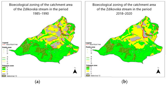
Figure 1.
(a) Bioecological zoning of the catchment area of the Zdíkovský stream in the period 1985–1990; (b) Bioecological zoning of the catchment area of the Zdíkovský stream in the period 2018–2020.
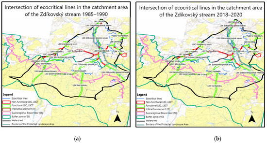
Figure 2.
(a) Intersection of ecocritical lines in the catchment area of the Zdíkovský stream in the period 1985–1990; (b) Intersection of ecocritical lines in the catchment area of the Zdíkovský stream in the period 2018–2020. Legend: LBC–local biocorridor; LBCT—local biocentre.
Graphical representation of the above changes in zoning of the area towards strengthening of zones A-B-C and elimination of unstable structures, mainly arable land, can be seen in Figure 1. Figure 2 below show the changes in the extent of ecocritical lines. Figure 2 clearly shows a significant reduction of the risk of ecocritical situations in the cadastral area under consideration.
These highly positive changes from the perspective of the stability of the area and minimization of negative factors affecting the components of the environment were implemented with the following key measures:
- Forest land
- Fringe communities along the edges of forest land, which will not be cultivated or used as pastures;
- In spruce monocultures, the mandatory proportion of near-natural species is maintained; cultivation by means of spruce monocultures has been reduced;
- In wet forest stands, species corresponding to these stands have been planted (spring and bog communities) and uncultivated forest appears in these areas;
- Forest roads are maintained, and appropriate measures have been adopted to prevent erosion;
- Meadows and pastures, scattered greenery
- Lands that are located near streams are excluded from this method of cultivation. Pastures have been fenced, and a different method of irrigation (other than from streambeds) has been ensured;
- Lands that have been waterlogged are not used as pastures so that natural succession takes place; fencing of the lands have been recommended;
- Natural restoration of Šumava pastures is overseen;
- Greenery is expanded by planting near-natural species mainly on sloping, erosion-prone lands, and large areas;
- Streams and wetlands;
- Sections in the places of the existing artificial fencing have been revitalized that do not pass through the inner centre of the municipality;
- All adjacent lands were excluded from cultivation, either intensive agricultural use or as pastures; alluvial valley areas have been delimited to unused permanent grassland;
- Wetlands are protected against ruderalization;
- Areas of wetlands are being expanded by delimitation of heavily waterlogged land;
- Roads and settlements;
- Vegetative strips of near-natural species resistant to exhaust fumes are planted along paved roads;
- Unpaved roads are protected against erosion;
- Settlements were separated from ecologically valuable species by scattered greenery.
The above proposals and measure aimed at eliminating the negative impacts of the existing ecocritical phenomena in the landscape do not represent a comprehensive, closed set of eco-optimization measures ensuring sustainability. The presented approach has mainly a methodological and methodical aspect of general validity, with each landscape segment representing a unique image and reflection of natural, anthropogenic, and anthropic structures. Therefore, it is necessary to implement this approach in a specific natural–economic framework. When dealing with a specific area, there are three basic stages. The first stage includes signalling, identification, spatial delineation, and the description of ecocritical lines. This is followed by the stage of landscape zoning in accordance with the methodology and analytical conclusions. The last stage, eco-optimisation, is a set of corrective and stabilization measures where it is recommendable to ensure feedback on the effectiveness of the solution to ecocritical lines balance before and after the implementation of the set of corrective measures.
6. Conclusions
The evaluation of landscapes in the catchment area of the Zdíkovský stream is based on the methodology presented in the habilitation thesis of Váchal [45]. This methodology was developed for agricultural areas. The catchment area under consideration is located in the Šumava foothills, where forestry and the use of permanent grasslands as pastures prevails. Therefore, it was necessary to modify and complement this methodology in some cases. The most prevailing subsystem is forestry, which is desirable for the lower orders of catchment areas. The high representation of permanent grasslands is also very appropriate in these geographical conditions. This also implies a high value of CES, which was nearly 6.5.
Fifty-eight ecocritical lines were determined on non-smooth transitions, with a high representation of B–D. After the design and implementation of environmental measures, this very negative situation has changed significantly. Out of the total number of 38 zones, the most represented ones are A–C (28 cases), and the number of A–D zones was minimized. A clearly positive change in the landscape character of the area in terms of environmental values has been confirmed.
The above-presented outputs as well as the principles and measures adopted for the area enable the confirmation of the first research hypothesis. In accordance with the comparison of zoning before 1989 and in the following period, it has been clearly proven that the higher representation of the agricultural and forestry subsystems in the area with an extensive use has significantly contributed to the environmental character of the area. The delimitation of arable land into meadows and pastures, or forest land and non-agricultural wetlands in some cases, also plays a dominant role. In this context, the anthropic pressure on the area was significantly reduced, mainly by eliminating chemicalisation and large-scale farming methods, including chemical plant protection. The second research hypothesis can also be considered scientifically verified, as the occurrence of ecocritical zones is demonstrably much lower than with the landscape structure before 1989. This was analysed also by means of regular sampling, when their quality in a number of measured profiles reaches the standards of drinking water, which was not possible in the past. However, in this context, the negative side of the extensive use of pastures shows, as in many cases, the natural potential of pastures is not fully exploited, and their noticeable degradation occurs. A similar degradation process also takes place in the animal drinking area. It has thus been confirmed that even under-exploitation of a landscape’s potential is harmful, as is excessive exploitation.
Author Contributions
Conceptualization, P.P., K.K. and J.V.; methodology, P.P. and K.K.; formal analysis, P.P. and K.K.; investigation, J.V.; resources, P.P., K.K. and J.V.; data curation, J.V.; writing—original draft preparation, P.P. and K.K.; writing—review and editing, P.P. and J.V.; visualization, J.V. All authors have read and agreed to the published version of the manuscript.
Funding
This research received no external funding.
Data Availability Statement
The data are stored in private databases at the Academy of Science in the Czech Republic and VŠTE.
Conflicts of Interest
The authors declare no conflict of interest regarding the publication of this article.
References
- Pártlová, P. Stanovení Ekonomického Potenciálu Venkovského Prostoru Jako Předpoklad Rozvoje Malého a Středního Podnikání; Vydavatelství a Nakladatelství Aleš Čeněk, s.r.o.: Plzeň, Czech Republic, 2021. [Google Scholar]
- Pártlová, P.; Dvořáková Líšková, Z.; Felcan, M.; Straková, J.; Váchal, J.; Polomský, J. New approach to determining the economic potential of rural area on the example of the south bohemian region of the Czech Republic. Entrep. Sustain. Issues 2020, 8, 914–931. [Google Scholar] [CrossRef]
- Miklós, L.; Kočická, E.; Izakovičová, Z.; Kočický, D.; Špinerová, A.; Diviaková, A.; Miklósová, V. Landscape as a Geosystem; Springer: Cham, Switzerland, 2019. [Google Scholar]
- Farina, A. Principles and Methods in Landscape Ecology; Landscape Series; Springer: Cham, Switzerland, 2022; Volume 31. [Google Scholar]
- Kühne, O. Landscape Theories: A Brief Introduction; Springer: Cham, Switzerland, 2019. [Google Scholar]
- Lososová, Z.; Divíšek, J.; Chytrý, M.; Götzenberger, L.; Těšitel, J.; Mucina, L. Macroevolutionary patterns in European vegetation. J. Veg. Sci. 2020, 32, e12942. [Google Scholar] [CrossRef]
- Latini, A.O.; Silva, D.P.; Souza, F.M.L.; Ferreira, M.C.; Moura, M.S.; de Suarez, N.F. Reconciling coffee productivity and natural vegetation conservation in an agroecosystem landscape in Brazil. J. Nat. Conserv. 2020, 57, 125902. [Google Scholar] [CrossRef]
- Tieskens, K.F.; van Zanten, B.T.; Schulp, C.J.E.; Verburg, P.H. Aesthetic appreciation of the cultural landscape through social media: An analysis of revealed preference in the Dutch river landscape. Landsc. Urban Plan. 2018, 177, 128–137. [Google Scholar]
- Drenthen, M. Rewilding in Cultural Layered Landscapes. Environ. Values 2018, 27, 325–330. [Google Scholar] [CrossRef]
- Bolles, K.C.; Forman, S.L. Evaluating landscape degradation along climatic gradients during the 1930s Dust Bowl Drought from panchromatic historical aerial photographs, U.S. Great Plains. Front. Earth Sci. 2018, 6, 153. [Google Scholar]
- Carrasco, L.; Giam, X.; Sheldon, K.S.; Papeş, M. The relative influence of history, climate, topography and vegetation structure on local animal richness varies among taxa and spatial grains. J. Anim. Ecol. 2022, 91, 1596–1611. [Google Scholar]
- Canedoli, C.; Ficetola, G.F.; Corengia, D.; Tognini, P.; Ferrario, A.; Padoa-Schioppa, E. Integrating landscape ecology and the assessment of ecosystem services in the study of karst areas. Landsc. Ecol. 2022, 37, 347–365. [Google Scholar] [CrossRef]
- Michanek, G.; Bostedt, G.; Ekvall, H.; Forsberg, M.; Hof, A.R.; De Jong, J.; Rudolphi, J.; Zabel, A. Landscape Planning—Paving the Way for Effective Conservation of Forest Biodiversity and a Diverse Forestry? Forests 2018, 9, 523. [Google Scholar]
- Littell, J.S.; McKenzie, D.; Wan, H.Y.; Cushman, S.A. Climate change and future wildfire in the western United States: An ecological approach to nonstationarity. Earth’s Future 2018, 6, 1097–1111. [Google Scholar]
- Turco, M.; Rosa-Cánovas, J.J.; Bedia, J.; Jerez, S.; Montávez, J.P.; Llasat, M.C.; Provenzale, A. Exacerbated fires in Mediterranean Europe due to anthropogenic warming projected with non-stationary climate-fire models. Nat. Commun. 2018, 9, 3821. [Google Scholar] [CrossRef] [PubMed]
- Yates, K.L.; Bouchet, P.J.; Caley, M.J.; Mengersen, K.; Randin, C.F.; Parnell, S.; Fielding, A.H.; Bamford, A.J.; Ban, S.; Barbosa, A.M.; et al. Outstanding challenges in the transferability of ecological models. Trends Ecol. Eval. 2018, 33, 790–802. [Google Scholar] [CrossRef] [PubMed]
- Povak, N.A.; Hessburg, P.F.; Salter, R.B. Evidence for scale-dependent topographic controls on wildfire spread. Ecosphere 2018, 9, e02443. [Google Scholar] [CrossRef]
- Li, C.; Xian, Y.; Ye, C.; Wang, Y.; Wei, W.; Xi, H.; Zheng, B. Wetland ecosystem status and restoration using the Ecopath with Ecosim (EWE) model. Sci. Total Environ. 2019, 658, 305–314. [Google Scholar] [CrossRef] [PubMed]
- Míchal, I. Ekologická Stabilita; Veronica: Brno, Czech Republic, 1994. [Google Scholar]
- Davis, K.T.; Dobrowski, S.Z.; Higuera, P.E.; Holden, Z.A.; Veblen, T.T.; Rother, M.T.; Parks, S.A.; Sala, A.; Maneta, M.P. Wildfires and climate change push low-elevation forests across a critical climate threshold for tree regeneration. Proc. Natl. Acad. Sci. USA 2019, 116, 6193–6198. [Google Scholar] [CrossRef]
- Law, D.J.; Adams, H.D.; Breshears, D.D.; Cobb, N.S.; Bradford, J.B.; Zou, C.B.; Field, J.P.; Gardea, A.A.; Williams, A.P.; Huxman, T.E. Bioclimatic envelopes for individual demographic events driven by extremes: Plant mortality from drought and warming. Int. J. Plant Sci. 2019, 180, 53–62. [Google Scholar] [CrossRef]
- McCann, K.S.; Cazelles, K.; MacDougall, A.S.; Fussmann, G.F.; Bieg, C.; Cristescu, M.; Fryxell, J.M.; Gellner, G.; Lapointe, B.; Gonzalez, A. Landscape modification and nutrient-driven instability at a distance. Ecol. Lett. 2020, 24, 398–414. [Google Scholar] [CrossRef]
- Von Bertalanffy, L. General System Theory: Foundations, Developments, Applications; Revised ed.; George Braziller: New York, NY, USA, 1968. [Google Scholar]
- Fath, B.D.; Asmus, H.; Asmus, R.; Baird, D.; Borrett, S.R.; de Jonge, V.N.; Ludovisi, A.; Niquil, N.; Scharler, U.M.; Schückel, U.; et al. Ecological network analysis metrics: The need for an entire ecosystem approach in management and policy. Ocean Coast. Manag. 2019, 174, 1–14. [Google Scholar] [CrossRef]
- Erős, T.; Lowe, W.H. The Landscape Ecology of Rivers: From Patch-Based to Spatial Network Analyses. Curr. Landsc. Ecol. Rep. 2019, 4, 103–112. [Google Scholar] [CrossRef]
- Vergés, A.; McCosker, E.; Mayer-Pinto, M.; Coleman, M.A.; Wernberg, T.; Ainsworth, T.; Steinberg, P.D. Tropicalisation of temperate reefs: Implications for ecosystem functions and management actions. Funct. Ecol. 2018, 33, 1000–1013. [Google Scholar] [CrossRef]
- Odum, E.P. Fundamentals of Ecology; Saunders: Philadelphia, PA, USA, 1971. [Google Scholar]
- Pomeroy, L.R.; Alberts, J.J. Concepts of Ecosystem Ecology: A Comparative View; Springer Science & Business Media: New York, NY, USA, 1988. [Google Scholar]
- Walker, J. More Heat than Life: The Tangled Roots of Ecology, Energy, and Economics; Springer: Singapore, 2020. [Google Scholar]
- Teben’kova, D.N.; Lukina, N.V.; Chumachenko, S.I.; Danilova, M.A.; Kuznetsova, A.I.; Gornov, A.V.; Shevchenko, N.E.; Kataev, A.D.; Gagarin, Y.N. Multifunctionality and Biodiversity of Forest Ecosystems. Contemp. Probl. Ecol. 2020, 13, 709–719. [Google Scholar] [CrossRef]
- Jordan, C.F. Evolution from a Thermodynamic Perspective; Springer: Cham, Switzerland, 2022. [Google Scholar]
- Elton, C.S. Animal Ecology; Macmillan Co.: New York, NY, USA, 1927. [Google Scholar]
- De Omena, P.M.; Srivastava, D.S.; Romero, G.Q. Consumptive effects and mismatch in predator–prey turnover rates cause inversion of biomass pyramids. Oecologia 2019, 190, 159–168. [Google Scholar] [CrossRef] [PubMed]
- Lindeman, R.L. The trophic-dynamic aspect of ecology. Bull. Math. Biol. 1991, 53, 167–191. [Google Scholar] [CrossRef]
- Ings, T.C.; Hawes, J.E. The History of Ecological Networks. In Ecological Networks in the Tropics; Dáttilo, W., Rico-Gray, V., Eds.; Springer International Publishing: Cham, Switzerland, 2018; pp. 15–28. [Google Scholar]
- Odum, E.P. Energy flow in ecosystems: A historical review. Integr. Comp. Biol. 1968, 8, 11–18. [Google Scholar] [CrossRef]
- Rigler, F.H. The concept of energy flow and nutrient flow between trophic levels. In Unifying Concepts in Ecology; van Dobben, W.H., Lowe-McConnell, R.H., Eds.; Springer: Dordrecht, The Netherlands, 1975. [Google Scholar]
- Jorgensen, S.E. Thermodynamics and Ecological Modelling; CRC Press: Boca Raton, FL, USA, 2018. [Google Scholar]
- Lotka, A.J. Elements of Physical Biology; Williams and Wilkins Company: Baltimore, MD, USA, 1925. [Google Scholar]
- Debecker, A.; Modis, T. Poorly known aspects of flattening the curve of COVID-19. Technol. Forecast. Soc. Chang. 2021, 163, 120432. [Google Scholar] [CrossRef]
- Melgar-Melgar, R.E.; Hall, C.A.S. Why ecological economics needs to return to its roots: The biophysical foundation of socio-economic systems. Ecol. Econ. 2020, 169, 106567. [Google Scholar] [CrossRef]
- Mougi, A. Coupling of green and brown food webs and ecosystem stability. Ecol. Evol. 2020, 10, 9192–9199. [Google Scholar]
- Patten, B.C. Network integration of ecological extremal principles: Exergy, emergy, power, ascendency, and indirect effects. Ecol. Model. 1995, 79, 75–84. [Google Scholar] [CrossRef]
- Culek, M. Biogeografické Členění České Republiky; Ministerstvo Životního Prostředí České Republiky: Praha, Czech Republic, 1996. [Google Scholar]
- Váchal, J. Metoda Postupné Projekce Ekologických Systémů Hospodaření; Habilitační Práce, Fakulta Zemědělská a Technologická, Jihočeská Univerzita: České Budějovice, Czech Republic, 2000; p. 152. [Google Scholar]


Publisher’s Note: MDPI stays neutral with regard to jurisdictional claims in published maps and institutional affiliations. |
© 2022 by the authors. Licensee MDPI, Basel, Switzerland. This article is an open access article distributed under the terms and conditions of the Creative Commons Attribution (CC BY) license (https://creativecommons.org/licenses/by/4.0/).