Article

Space Redevelopment of Old Landfill Located in the Zone between Urban and Protected Areas: Case Study

1
Institute of Civil Engineering, Warsaw University of Life Sciences—SGGW, Nowoursynowska 159, 02 776 Warsaw, Poland
2
Department of Plant Biology, Faculty of AgriSciences, Mendel University in Brno, Zemědělská 1, 613 00 Brno, Czech Republic
3
Faculty of Civil Engineering, Silesian University of Technology, Akademicka 5, 44 100 Gliwice, Poland
4
Department of Applied and Landscape Ecology, Faculty of AgriSciences, Mendel University in Brno, Zemědělská 1, 613 00 Brno, Czech Republic
*
Author to whom correspondence should be addressed.
Energies 2022, 15(1), 146; https://doi.org/10.3390/en15010146
Submission received: 10 October 2021 / Revised: 14 December 2021 / Accepted: 23 December 2021 / Published: 27 December 2021
(This article belongs to the Special Issue Sustainable Smart Cities)

Abstract

:
Landfills are elements of the waste management system, without possibility of further reclaiming, according to the requirements of a closed-loop economy, but with the possibility of transforming the area into other functions. The research combined monitoring of plant species, suggesting the composition of vegetation cover for pro-ecological management, analysis of functional and infrastructural incorporation of the landfill in the surrounding landscape, and proposals for reclamation and social application. An assessment of geotechnical safety was also made. Modernization of the landfill suggests that the pressure placed on other untouched locations should decrease. The designed space allows reintroducing socio-ecological life into this degraded area. Taking advantage of the character of the area, including variable development and significant landscape potential on the outskirts of a large city in the vicinity of protected areas, there is the possibility of creating new spatial quality following the standards of modern architecture-urban planning. One of the innovative elements of the project is the implementation of energy from renewable sources, including landfill biogas, photovoltaic panels and heat pumps. The development design includes social expectations and adaptation of new techniques to functioning in times of increased sanitary threats. The proposed design direction may be considered as a recommended trend for the sustainable development of urban areas.

1. Introduction

There is a common definition of what creates an intelligent city and what is a sustainable city. An intelligent city refers not only to an intelligent infrastructure but the extent in which this infrastructure helps in achieving the aims of sustainable development goals [1]. One of the fundamental challenges in the improvement of wellbeing in urban areas is the proper management of waste which originated from the development of industry, administration, and trade, as well as the behaviour of consumers. The rate at which waste is produced rises quickly due to improvement in living conditions, urbanization, and economic development [2]. Effective waste management is critical for the improvement of living standards and for minimizing negative impact on the environment [2,3,4,5]. Therefore, management of post-landfill space, based on the same rules as the design of any other urban-landscape space [6,7], is equally important. In modern city development policy, adaptation of similar areas formed after reclamation is linked with the broad idea and rules of Smart Sustainable Cities [8,9,10,11,12,13], as well as “local city values” [14]. Moreover, areas of waste landfill play a different role in the ecosystem and the presence of such structures in the landscape assures cultural identity and becomes a navigation point, allowing simple identification of other landscape elements [7,15]. The issue gains particular significance in the case when landfill is located close to protected or inhabited areas [16,17]. Reclamation and management of landfill areas are also types of compensation for the surrounding areas and inhabitants for the long-term inconveniences related to the exploitation of such structures. Waste management (also linked to waste dumping) and pro-environmental reclamation measures present challenges in the modern world, reflected in various types of hazard imposed on our civilization, including the recent pandemic [18,19].
The management of former landfill sites varies in terms of local conditions and development opportunities. Depending on the country, the management policy for urban restoration of former landfill sites varies [20,21,22,23,24,25,26,27,28,29,30,31,32,33,34]. The restoration of landfill within urban areas involves many factors. Natural, economic and social factors are crucial. However, the overall goal is to remediate these areas to bring the urban and landscape functions back to their original condition [21,22,27,35,36,37,38,39,40]. Once restored, such areas can serve a variety of functions: recreational, sports, exhibitions, parks, museums [21,27,40,41,42,43,44]. In general, there are several basic approaches suggested by urban planners and landscape architects to revitalizing landfills: (1) cover-up, (2) restoration, (3) recycling, (4) mitigation, (5) sustainable development, (6) educational, and (8) integrative. Each category is related to the designer’s approach and the specific planned function in the city’s structure that the revitalized landfill is to serve in the future [21,41]. Planning of the spatial development of restored areas involves a specific strategy. First comes detailed spatial analysis of the structure of the area and its surroundings, which also includes elements concerning the planning of future protection [21,34,35]. Then, inventory analyses of vegetation cover, facilities and transportation accessibility are performed. The next stage is to perform analyses of the urban composition of the site and neighbouring areas. Then, an analysis of visual and aesthetic effect is performed. The results then become guidelines for further development design [7,23,24,25,30,35,45].
The authors of the present study have concentrated not only on reclamation measures for the landfill site, but also on an attempt to design a structure in such a way as to ensure the safety of people using it during the pandemic [46,47,48]. Therefore, new standards in architectural design and spatial management are introduced, responding to the requirements of a new epidemiologic reality [49,50,51,52].
Landfill reclamation projects increase the opportunities for creating open urban space [53,54]. The present study is a proposal for developing a landfill site for recreation-leisure purposes. It proposes a design for the area to locate a yearlong, roofed ski slope with appropriate functional and technical infrastructure. The preparation of the structural design is based on an analysis of the area and the geotechnical safety of the entire site [55], as well as its context regarding communication, composition, and infrastructure. The functions of the nearby vicinity and housing were considered [7,56,57,58]. An effective reclamation plan required the following goals: (i) assessment of geotechnical safety of the landfill concerning the new development plan, (ii) monitoring of plant species capable of establishing on a waste landfill, (iii) proposing the vegetation composition suitable for landfill reclamation, and (iv) analysis of functional and infrastructural incorporation of the landfill in the surrounding landscape. Places with an ecological burden can be used to redirect local residents and tourist pressure away from ecologically valuable places and towards revitalized places. The tourist and sports activities of the inhabitants, which will be carried out on reclaimed landfill, can contribute to the redistribution of visitors, and thus reduce the pressure on natural and ecologically protected valuable areas (e.g., Kampinos National Park and natural reserves).
The authors present the results of research into the landfill site reclamation process. It is a practical example of incorporating landfill sites into an urban structure through a project allocating restored land for recreational purposes. The authors intended to fill knowledge gaps regarding this issue, as generally in the existing literature there are very few examples showing all the stages of transformation and design of landfill sites, with special attention given to their recreational function. Using the example of the Radiowo landfill, the entire development process from reclamation to urban landscape and architectural planning is shown.

2. Materials and Methods

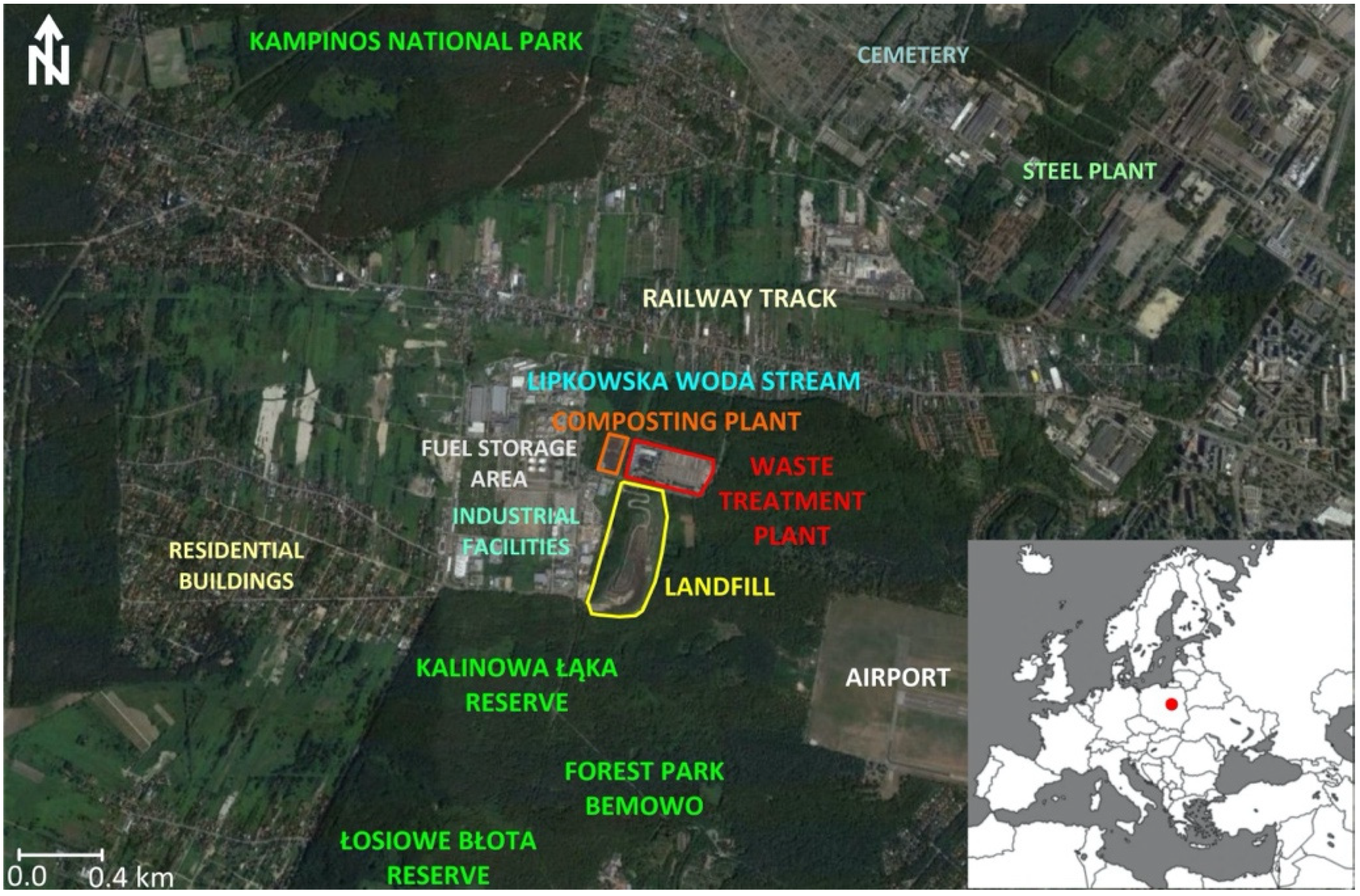
2.1. Characteristics of the Study Site and Its Location

The Radiowo landfill is located in the Stare Babice commune and partially (about 17% of its area) in Warsaw, Poland (Figure 1). The landfill was established in the early 1960s, and from the beginning of the 21st century it was shaped into future forest-recreational development (according to the expectations of the nearby community), to be finally closed down after technical remediation in 2018.
From the north, the landfill lies adjacent to the composting plant located in the Warsaw-Bielany District. From the south and east, the landfill is surrounded by the “Bemowo” Forest Park with Nature Reserves: the floristic “Kalinowa Łąka” and the peat-wetland “Łosiowe Błota”. To the west are a railway side-track and industrial facilities. A large fuel storage area is located to the northwest. At a distance of about 350 m from the composting plant and 400 m from the landfill, there is a watercourse connected to the Lipkowska Woda stream. At a distance of about 2 km to the northwest of the landfill run the boundaries of the Kampinos National Park (Figure 2).
The landfill covers an area of ca. 16 ha and reaches an elevation of about 60 m. Initially, no protection system against environmental contamination was adopted at the landfill site.
The area has good communications; the main access is from Kampinoska Street, but secondary access from Kampinoska Street (northeast corner of the landfill) or direct access from Estrady Street to the south is also possible. Electricity and water are supplied to the landfill. The landfill is equipped with a degassing system; biogas energy is discharged to the power grid, but in the future may be used in the newly proposed development. The landfill possesses non-systemic effluent drainage (peripheral drainage, finger drainage, and drainage of landfill slopes’ benches) and a pumping system for effluent transmission to the sewage reservoir, which after modernization could also be used for the planned development. Due to the close vicinity of the sporting-emergency airfield “Bemowo”, a warning traffic light is installed on the landfill crown.
Concerning the landscape composition, the landfill is a local landmark surrounded to the south and east by the flat ground of Las Bemowski with wide scenic exposure to the Warsaw panorama to the east. To the north and west are the visible distinct architecture-landscape interiors of Kampinoska, Estrady and Arkuszowa streets [7,45,58]. The area is also surrounded by smaller industrial, service and housing infrastructure. to the northwest is a fuel base and laboratories, as well as a green waste composting plant and a municipal waste handling plant. Industrial buildings with storage, workshop and commercial functions are located to the west. The exposure to the north and west is not attractive.
It was argued that, due to its location in a zone between urban and protected areas, the landfill after reclamation and redevelopment could perform the function of a buffer zone between these two specific sites [59]. The role of buffer zone is extremely important in terms of maintaining sustainability, biodiversity control and strengthening the natural values of the landscape [60].
Since 1994, remedial works were implemented in the landfill. They included stability reinforcement, shaping the slopes, clay mineral capping, installation of drainage and recirculation systems, as well as application of a bentonite vertical barrier, creating a containment zone surrounding the landfill. The vertical barrier was designed to minimize the spread of contaminants into the surrounding environment and to provide suitable hydraulic conditions by forcing a lowered groundwater level inside the peripheral vertical barrier to avoid potential contamination of the natural groundwater level around the landfill site.
A major part of the reclamation works was the assuring of the geotechnical safety of the landfill. Verification was performed by analysing landfill body displacements and slope stability. The analyses of landfill geometry deformations were based on a geodetic survey using the network of benchmarks installed on the landfill. The analyses were followed by Finite Element Method (FEM) modelling to simulate future potential displacements. To perform geotechnical safety analyses, mechanical parameters of waste were investigated by using three main groups of tests. These included back analyses, trial loading and geotechnical in situ tests. Geotechnical testing methods included the Cone Penetration Testing (CPT), Weight Sounding Test (WST), and Heavy Dynamic Probing (DPH). The unit weight of waste was obtained from field tests carried out using open excavations. The evaluation of water quantity per volume unit of waste was performed using the Time Domain Reflectometer (TDR). Trial loading with concrete slabs was performed on several sections of the experimental embankment, using the trial loading method [61]. The loaded sections differed in the type of embedded material. Moreover, as part of the geotechnical investigation, WST was performed to assess the density of waste in the landfill and to locate the mechanically weakest layers where potential slope failures and deformations could occur. This analysis was also useful for qualitative evaluation of the uniformity of waste profiles and for identification of loose material forming the landfill body. The locations of non-compacted layers were then denoted for further mechanical compaction [61]. Waste geotechnical parameters are given in Table 1. The factor of safety computation allowing verification of slope stability was based on a Limit Equilibrium Method (LEM) and FEM, incorporating the approach of pull-out resistance for the cross-sections where reinforcements such as geogrids were installed. The geogrid is a net made of high-density polyethylene (HDPE) used for reinforcing the landfill slopes, and in this case aims at protection against landslides (geotechnical safety). For computation of geotechnical safety for cross sections where geogrids were installed, resistance reduction factors were used depending on stress distribution or material deterioration rate [61].

2.2. Monitoring of Existing Vegetation Cover

Before the start of the vegetation cover survey, the area was assessed several times in terms of overall condition and zones were created according to management, carried out at the landfill site. The aim was to determine the species composition of vegetation and the relationship between vegetation and management. The plant composition was analysed using standard phytocoenological relevés according to the principles of the Zürich-Montpellier (Braun-Blanquet) school, which is used to illustrate the complex conditions of the site. Braun-Blanquet involves describing recognizable units in the vegetation of a region by the description of the vegetation in a single representative standard plot—a relevé—within each unit. The sites of the phytocoenological relevés were selected to represent as much as possible the character of the vegetation. Monitoring was conducted in July 2019 and verified in September 2020. All taxa of plants growing on the permanent plot were identified, and then the cover was estimated for the biomass of individual taxa. Scientific names of plant species were collected from the database of the Czech flora and vegetation Pladias [62]. Based on the information from the Pladias database, the plant species were classified into several groups according to their ecological effects. The surface area of the phytocoenological relevés was 25 m2. The relevés from the units were then analyzed to develop descriptions and classifications of the vegetation cover in the studied landfill. The landfill area was sub-divided into three sites depending on the management type: (i) surfaces subjected to fieldwork, compost fertilization, plant mowing (TM_I); (ii) surfaces without significant fieldwork but with mowed grass (TM_II); and (iii) surfaces without influence on the vegetation cover (TM_III). The approximate area for TM_I is 4.0 ha; TM_II 5.0 ha; TM_III 6.5 ha and 0.5 ha. The coverage of the recognized plant species was estimated as a percentage, and15 phytocoenological relevés were prepared for each site.

2.3. Methodology of Statistical Processing

The phytocoenological relevés were evaluated by using multidimensional analysis of ecological data with Detrended Correspondence Analysis (DCA) and Canonical Correspondence Analysis (CCA) [63,64]. Multivariate analyses make it possible to explain the relationship between the explanatory variables, but also to explain the relationship between the plant species found. DCA provides the length of the gradient. DCA is a technique to summarize ecological changes through time and to ordinate ecological data. CCA defines the spatial arrangement of individual plant species and monitored sites based on data on the frequency of occurrence and coverage of plant species, which is graphically expressed by an ordination diagram. The plant species and the studied sites are presented as points of different shapes and colours. If the points of a certain site and plant species occur close to each other, the species occurred in the given site more frequently or had a larger coverage. Significance testing employing the Monte-Carlo test included the calculation of 999 permutations. Monte Carlo tests of significance are distribution-free. They do not require normality for the error distribution. This makes it possible to respect the heterogeneity of the data, which is very typical for vegetation data. However, they do require independence or exchange ability. In Monte Carlo tests, the permutations are therefore restricted to random interchanges within each plot. Data were processed using the Canoco 5.0 computer software [65]. In Canoco, explanatory variables can be made covariables so as to adjust for their effect on the species data. Canoco was used to assess the overall variation patterns in species composition. The statistical tests of significance were carried out by Monte Carlo simulation.

3. Results

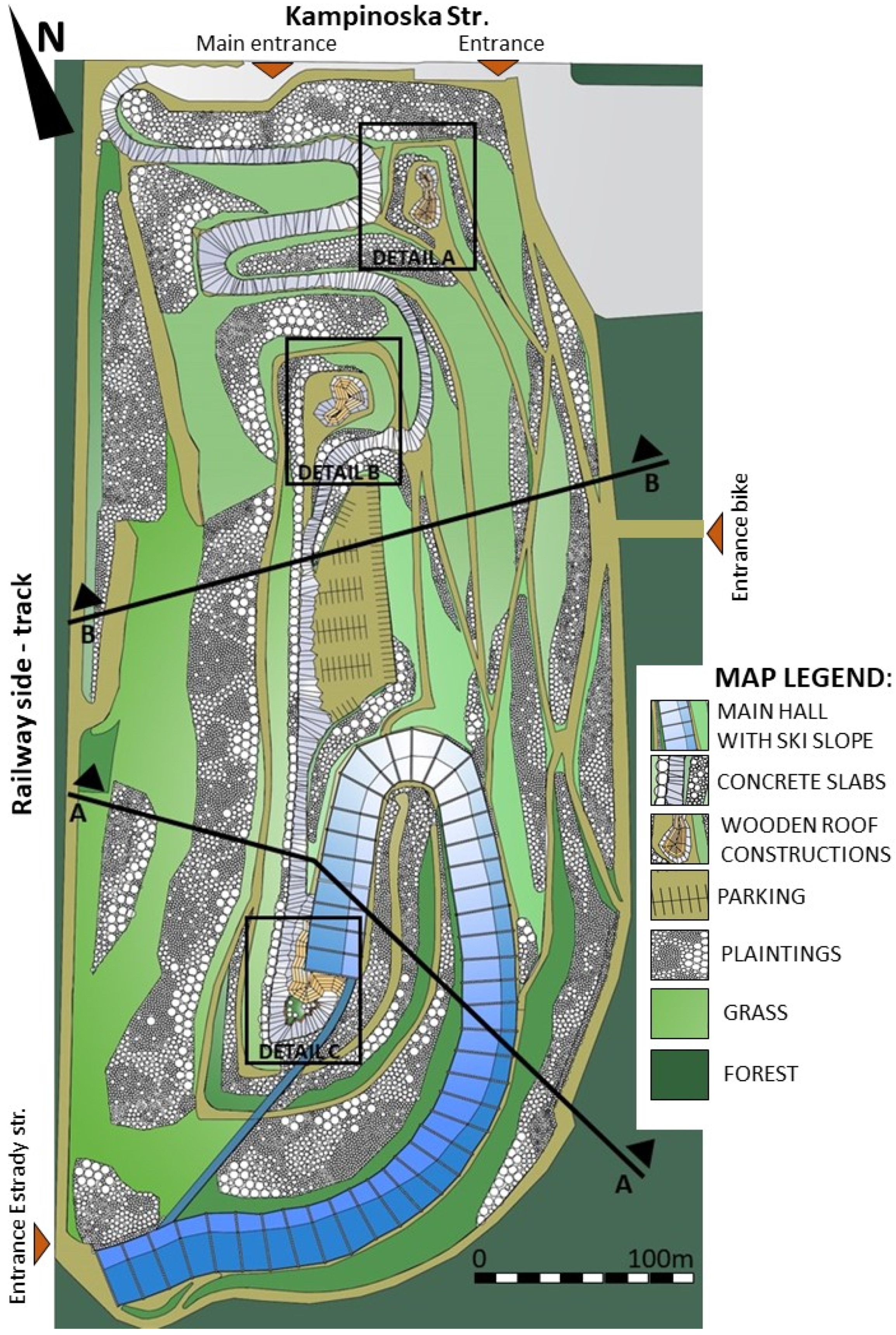
3.1. Project of Object Development

The analysis has shown that the area requires amendments in communication conditions; at present, the main access is from Kampinoska Street, whereas using a second access-way from Kampinoska Street at the base of the slope and restoration of the “old” entrance from Estrady Street to the southern part of the landfill is also possible. The concept of landfill development is presented in Figure 3. Based on the analysis, communication, functional, compositional, and infrastructural assumptions, corresponding to the new demanding social circumstances related to restrictions caused by the pandemic situation, have been made. First, broader routes to the interior (in the planned building of the roofed ski slope) and outdoor communication in the planned development have been designed. The functional scheme complies with the rules of social distancing according to epidemiological guidelines (ensuring a minimum distance of 2 m) and a system of restricted access with an assumption of 15 m2 per person in closed space and 7 m2 per person in open space [48,50,66,67]. The structure composition fulfils the rules for continuing the existing spatial composition, conforming in scale to the landscape and to urban possibilities [7,45,58,68]. The project of landfill development assumes the construction of the main building with a roofed ski slope, essential technical infrastructure, and a service-catering facility (Figure 3). The area subject to the development plan assumes the design of pedestrian routes and a paved access road with necessary parking facilities [69,70,71,72]. Additionally, two roofed structures playing the role of observation-recreational decks with restaurants have also been designed (Figure 4).

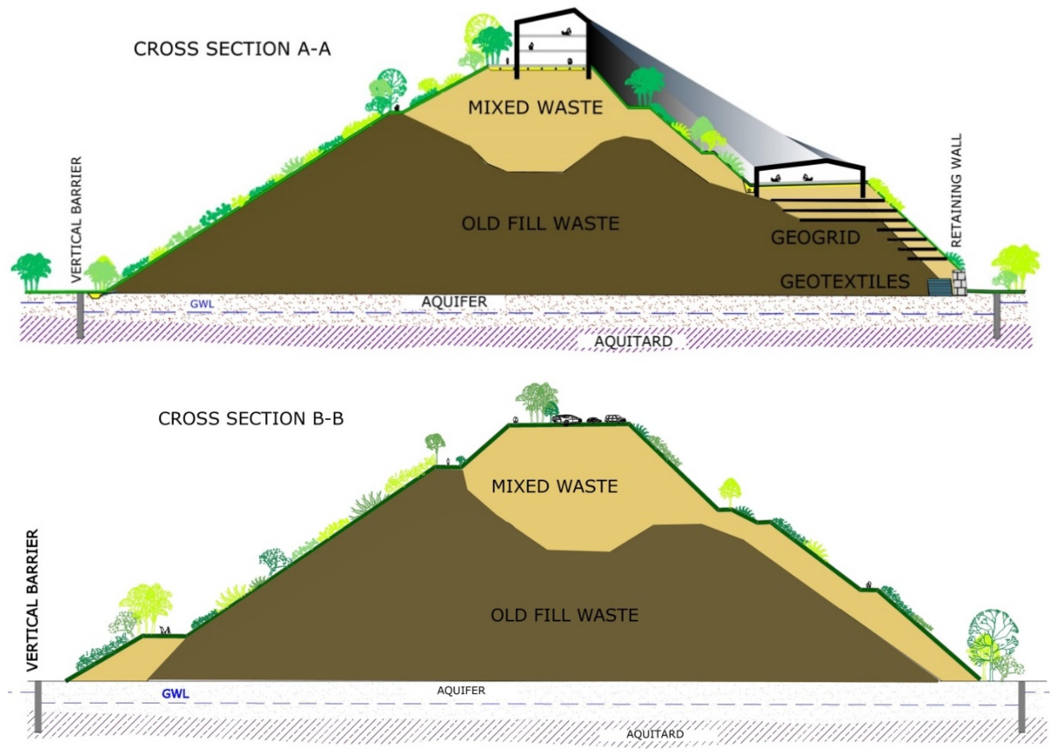
3.2. Geotechnical Aspects of Slope Stability

One of the main challenges of reclamation works proposed on the Radiowo landfill was to improve the geotechnical safety and stability conditions to ensure that the structure could be used as a ski slope. Due to ownership issues of the area adjacent to the landfill site, engineering works on slopes consisted mainly of retaining structures or ground improvement methods. Steel sheets were used to reinforce the northern part, with layers of high-density polyethylene (HDPE) geogrid above. Additionally, a masonry retaining wall, 6.2 m in height, reinforced with geogrids and geotextiles was constructed in the southeast [61]. To improve the ground conditions, a mixture of soil and ballast waste was compacted in layers, and used tyre mattresses were installed. The development plan with cross-sections for a detailed presentation of the reinforcements is shown in Figure 5. Due to the new development plan of the landfill site, it was also necessary to design additional structures such as an earth embankment in the southern part. The inclinations of slopes are planned to be from 1:1.5 to 1:2. In other parts of the landfill, loading embankments, anthropogenic material mixtures, and mattresses of used tires were also applied. In the case of Radiowo landfill, the main challenge was to precisely determine the geotechnical parameters of waste built into the slope, so that the stability analyses could be reliable. The selected cross-sections for computations comprised the retaining masonry wall, used tyres, geotextiles, and layers of HDPE geogrid [61]. The slopes were reinforced successively during the construction of berms with the use of mixed waste and an increase in the height of the landfill. Cross-sections through the landfill with reinforcements and a new engineered geometry are presented in Figure 5. Technological benches on the slopes play a significant geotechnical safety role, but in the landfill development plan they may be used for communication related to slope maintenance and repair, as well as recreational routes for pedestrians, jogging, cycling, and cross-country skiing. Geotechnical safety computations revealed that the proposed solutions retain secure values for the safety factor, accessed for local and global slip surfaces in different phases of landfill exploitation. To avoid obtaining an uncertain and unreliable geometry of the critical slip surfaces, the calculations involved both the LEM the FEM. For the final FEM computation, 8-node quadrilateral elements were assumed and a shear strength reduction model was applied. The failure planes computed using Bishop and Spencer methods were analysed to achieve the most reliable factors of safety (FOS). The calculations for LEM were based on Bishop, which applies the method of slices, but in contrast to Spencer and FEM, it assumes only a cylindrical critical shear plane. For this reason, for uncertain sections, FEM analyses were suggested. Comparing these two approaches (LEM and FEM), it was noted that the locations and shapes for plotted slip surfaces in particular sections are very much similar (bearing in mind that Bishop’s method considers only cylindrical slip surface). The results for FOSs (global and local) revealed insignificant differences in local and global FOS. The calculations made for different cross-sections of the landfill indicated that the FOS values were in the range from 1.27 (in the western part) to 1.36 (in the northern and eastern part). FOS greater than 1.2 were obtained for all reinforced landfill slopes, which can be considered secure concerning geotechnical safety practical requirements. The comparison gave a clear indication that the results are reliable and that the reinforcements act appropriately since all the measures were aimed at meeting the safety requirements stated in the new development plan for the restored site [61].

3.3. Communication Premises of Territorial Development

The landfill site development plan assumes connection with an existing road network with a right- and left-hand entrance/exit through Kampinoska Street. Communication with the building of the roofed ski slope will take place through an entrance road connected with a small manoeuvring square adjacent to the street. The manoeuvring square will ensure a temporal stopover of buses and delivery cars. A parking lot with standard parking spots and with the possibility of parking buses and delivery cars is planned for about 100 vehicles on one of the flat terraces, at a distance of about 60 m from the main exit to the building, according to the clauses of Polish special development law [70,71,72]. A larger number of parking spaces on the landfill top is not possible due to excess loading and the associated landslide risk. More parking spaces will be available on the site of the former composting plant, which is undergoing liquidation. In addition, access from the centre of Warsaw to the facility (after the investment is completed) will be provided by public transport, including the use of a metro line, located approximately 3 km from the landfill. Two-way traffic with a speed limit of 30 km/h is planned on the access road. The system of deliveries will be accomplished through the zone of temporal stopover, parallel to the entrance to the building located in the west. A connection in the southern part of the landfill with access from Estrady Street or Kampinoska Street along the western landfill escarpment is also possible. About 5000 pathways on technological benches, which may also play the role of cross-country skiing, cycling and jogging routes, have been designed. Observation decks are planned on two flat areas near the parking lot and the landfill crest from the north. The flat ground located above the second bend of the access road in the north-eastern corner of the landfill may also be used for recreational and other purposes. An additional observation deck has been located on the top of the landfill to the south of the building. A pavement composed of irregular concrete slabs via construction technology assuming a load of up to 20 tonnes has been planned on the access road. The same paving is planned for the area around the main building. The parking lot and the pathways will be rubble-gravel with the pavement made of natural rock aggregates. The observation decks will have both types of pavement [69,70,71,72]. The designed transportation system tries to meet the requirements of Polish law, while providing the widest possible access for pedestrians, cyclists and the disabled. Paths and access roads are designed to provide the best possible access to all parts of the facility and allow for full use of the area for summer and winter sports.

3.4. Functional, Infrastructural and Compositional Relationships with the Surroundings

A two-storey building has been designed to be located in the landfill crown. With service-shopping functions, it will have a roofed, all-year-round ski-snowboard slope. The entrance zone to the building is from the west, adjacent to the top of the entrance road. An adjacent observation deck is planned on the southern side of the building, with seating places designed to assure alternative social distancing. Such conditions have also been arranged in the two other observation decks. Similarly, solutions allowing for maintaining proper distances between the visitors have been planned in the ski slope building. This was achieved by designing broadened 5 m wide corridors and vertical communication with restricted access control, considering emergency cases. Besides technical and sanitary areas, the ground floor of the building will have shops and restaurants. The first floor will contain a food court and service areas related to the rental and conservation of ski and snowboard equipment. Additionally, a cloakroom including personalized lockers and changing rooms has been planned. The food courts have been designed to maximally shorten the high-risk infection pathways with optimization of the preparation surface to ensure social distancing among the personnel. Zones for clients have also been designed accordingly—the sitting places around the tables guarantee to maintain at least 2 m as the radius of each table. The entrance to the ski slope with admission control is also planned on this level. Between the slope entrance and the remaining rooms on the second floor, a buffer zone guaranteeing thermal control and safety during temperature change is designed. A covered conveyor belt linking the beginning and end of the ski route is intended between the lower end of the slope and the main building. It is assumed that admission to the slope and the conveyor belt will include restricting the number of visitors to ensure maximal epidemiological safety; therefore, additional admission control is projected. The structure will have a steel construction with up to 30 m wide frames made of glued laminated timber, located on a pile foundation. The elevation is planned using aluminium-glass system technology. Large glass windows enabling viewing of the Warsaw panorama are planned on the building front on the hill crown. The roof will be covered by sheet metal. Openwork wooden-steel roofing is planned in the south-western part of the building and on the two observation decks. Pergolas on the observation decks will also be constructed with the same technology.
The main hall has been designed in a recuperation system using heat pump technology and photovoltaic panels. In the first years of the facility’s operation, the energy obtained from the existing landfill degassing system will be used to improve the energy balance. The electricity produced from biogas will be used more efficiently on-site than it is currently when sold to the public power grid. Additionally, a surface comprising photovoltaic panels is planned on the western exposure to improve the energy balance of the structure. It was assumed that the energy obtained from biogas, heat pumps and photovoltaic panels should ensure the full energy demand of the planned facilities, including the needs of the year-round snow covering of the covered ski slope.
The closed circuit will also use biomass collected from the slopes of the landfill and then composted in a green waste composting plant located next to it. The final product will be used to fertilize and improve the habitat conditions of plants. Such use is in line with the principles of a closed-loop economy. The conducted research and previous experiences [73] show that compost (Table 2) can effectively replace humus which is increasingly difficult to obtain, but necessary for the biological development of landfill slopes and other reclamation treatments. In the current study, the depth of the substrate (compost) applied at the landfill slopes during the reclamation was in the range 0.2–0.3 m. The total depth of the cover system (with all technical layers used) was about 2.5 m. The building was designed to meet the requirements of contemporary pro-environmental design. All technical systems are designed to meet the requirements of a closed loop economy as far as possible.

3.5. Monitoring Results of the Existing Vegetation

Table 3 presents the number of species from four plant groups according to their forms (trees and shrubs; grasses; perennial green plants; annual green plants), and 105 taxa have been recognized based on vegetation monitoring.
Results of CCA evaluating the occurrence of plant species in the studied sites were significant at the level of α = 0.001 for all canonical axes. Based on CCA results (Figure 6), the detected species can be classified into four groups. Development type TM_I was characterized by the following species: Atriplex sagittata, Aethusa cynapium, Bassia scoparia, Iva xanthiifolia, Elytrigia repens, Festuca rubra and Sisymbrium loeselii. Development type TM_II was dominated by: Dactylis glomerata, Lolium perenne, Tussilago farfara and Xanthium albinum. Development type TM_III was characterized by: Acer negundo, Bromus sterilis, Bromus tectorum, Conium maculatum, Prunus cerasifera, Robinia pseudoacacia, Rumex acetosa, Sambucus nigra, Solidago canadensis, Tanacetum vulgare and Urtica dioica. Some species prevailed in the vegetation cover and occurred in all analyzed surfaces, e.g.,: Arctium lapa, Artemisia vulgaris and Lactuca serriola.
In this study CCA was used to evaluate the effect of the studied sites on the vegetation structure. Moreover, CCA was applied because the data set was relatively heterogeneous and therefore the length of ordination axes in DCA was relatively long. The Monte Carlo permutation test was used to reveal the effect of the obtained explanatory variables on the plant species composition.

3.6. Local Plant Species which May Be Used for Landfill Remediation

The main purpose of the vegetation inventory was to find plant species that can survive in a very diverse and very specific environment of the landfill. Some plant species already occur on the landfill site and therefore they are capable of surviving in demanding landfill conditions. Some species mentioned in Table 4, which indicates species related to the catalogued local plants, may also be planted on the landfill according to the vegetation development plan, particularly those species which will influence the water balance and increase erosion control on the slope surfaces.

4. Discussion

The proposed design direction may be considered as a recommended trend in the sustainable development of areas located between urban and protected zones [14,54,59,68]. The new development plan presented in previous sections (see Section 3.3, Section 3.4 and Section 3.5) consists of sustainable construction of buildings providing all sorts of leisure services as well as an all-year-round ski-snowboard slope. The area is planned to be covered with vegetation of specifically selected plant species, which will be maintained using the landfill resources (irrigation with rainwater and leachate, bio-fertilizers with compost) [73]. All the facilities are planned to be supplied with energy converted from the landfill generated biogas, heat pumps and photovoltaic panels installed on the main building roof and selected landfill slopes. The monitoring results presented in Section 3 proved that the combined sustainable system can be efficient. Properly selected vegetation is an important indicator of the effectiveness of remediation activities and integrates the area into the surrounding landscape. However, before implementing new infrastructure and establishing vegetation cover, the entire area needs to be prepared according to the strict requirements discussed in the study. The designed space allows the reintroduction of the degraded area into socio-ecological life. Taking advantage of the character of the area, including variable development and a huge landscape potential on the outskirts of a large city in the vicinity of protected areas, there is a possibility of creating new spatial quality following the standards of modern architecture-urban planning.
Activities related to the implementation of vegetation on the landfill slopes and the implementation of new land development is possible after the completion of technical reclamation works aimed at ensuring geotechnical safety [61]. This is especially important for high landfill slopes where there is a risk of landslides. For stability analysis, a number of tests of the state and geotechnical parameters of the deposited waste are necessary [61,74]. Comprehensive engineering solutions were applied to improve the landfill stability conditions, including berms, horizontal reinforcements with geogrids, retaining structures and waste compaction [61]. Technical reclamation of municipal waste landfills also includes the installation of degassing system, using in the energy recovery process [28]. Published accounts indicate that vegetation is an indispensable element of landfill sites [55,63,64] and can adapt to very diverse environments [75]. Therefore, knowledge of plant succession is the basis for solutions aiming at retrieval and recultivation of degraded ecosystems in solid waste landfills [55,64]. The need for design work related to the correct selection of plants and spatial development for an old construction waste landfill into a recreation ground was also indicated by Długoński [15] in his studies conducted in the Górka Rogowska landfill in Łódź (Poland). Survival conditions on landfills pose specific stress to plants, which leads to a change in plant species diversity. The stress is caused by a large content of nutrients, salts, heavy metals, and other toxic elements in the soil, as well as restricted water resources. The specific conditions of municipal solid waste landfills promote the occurrence of a limited number of plant species. In contrast, the results of studies performed in the landfill by Vaverková et al. [5] show that the landfill constitutes a specific environment. Living conditions are extremely difficult and demanding in landfill environments [5,16,76]. In any case, landfilled municipal solid waste may disturb the species composition of native vegetation and create a space for the development of synanthropic and invasive species [64]. These species may later disperse from the landfill and influence the species composition of natural ecosystems [64]. It is also important to perform monitoring studies to counteract the negative influence of anthropopression by appropriate management of the introduced vegetation, including plant control [64] and elimination of invasive species. Similar recommendations were suggested by Pang et al. [77], who proposed two methods of dealing with degraded habitats on waste landfills to improve the ecological succession: (1) accepting an increase in number and diversity contribution of tree species for primary planting in degraded habitats, and (2) active management of vegetation planting by controlling the number and density of exotic or invasive species. Even though investigations of biocoenosis composition (diverse community) inhabiting landfills are a long-term process, they are of fundamental significance for the understanding of the complex dynamics of the processes on which remediation of degraded areas is based [78]. Moreover, vegetation should be analysed as a whole [63]. Rebele and Lehmann [79] indicate that case studies based on long-term analyses may supply knowledge of plant development in a specific area and general information on succession mechanisms, as well as other types of vegetation dynamics.
Plant species capable of managing and utilizing specific stress have been identified based on the performed vegetation monitoring. They include: the trees Acer negundo and Robinia pseudoacacia, shrubs: Prunus cerasifera, Prunus spinosa and Sambucus nigra, green plants: Achillea millefolium, Melilotus albus, Melilotus officinalis, Oenother abiennis, Onopor dumacanthium, Solidago canadensis and Tanacetum vulgare; and grasses Dactylis glomerata, Festuca pratensis, Festuca rubra and Lolium perenne. These species may be applied in the reclamation and later modifications. For comparison, in the aspect of vegetation selection for reclamation requirements, Wong et al. [80] have indicated that in some conditions exotic plants may be more relevant for application as pioneer species during reclamation of sanitary landfills. They have also shown the validity of applying plant species from the families Acacia and Mimosaceae as pioneer plants on landfills. Within the project, plant species (Table 4) that already grow here, or related species, were selected so that the vegetation fulfils a number of ecological functions. In the case of the proposed project, the three main functions are: (i) aesthetics, (ii) preventing erosion, and (iii) evapotranspiration. The aesthetic function is maintained by flower and leaf colours, the shape of plant habitus, etc. A significant role is played by the characteristics of plant maintenance. Due to the landfill slope dip, the erosion-preventing function is irreplaceable. Among the selected plant species, this function is played mostly by shrubs and trees (Acer negundo, Robinia pseudoacacia). Grasses (Dactylis glomerata, Festuca pratensis, Festuca rubra, Lolium perenne) and some green plants (Solidago canadensis, Tanacetum vulgare) have an anti-erosion function on slope areas. Selected plant species play both aesthetic and erosion prevention features. Worth noting is the fact that reconstruction of vegetation on waste landfills is not only an effective method of preventing surface flow and erosion but the key solution for restoring ecosystems in ecologically sensitive areas [81,82]. Because vegetation cover, soil and topographic factors are strictly connected with each other, it is very important to understand the influence of soil conditions and topographic factors on plant restoration during biological remediation to assure effective remediation of soils and ecological renewal in waste landfills [79,83]. Evaporation functions are crucial for sustainable water balance in the landfill and a lower volume of landfill effluents [55].
The continuous development of human population [5] in an urban environment requires an integrated engineering approach, landscape planning and a design that maximizes social-economic and ecological advantages. Redevelopment of an old waste landfill site allows society to utilize these degraded areas and thus preserve other, more valuable lots for their usage as high-value areas. Subsequent developments of old waste landfills may allow society to utilize the grounds in a way that would be impossible in a fully developed area. Closed-down landfills ensure access to green zones in urban areas so that society may live in a healthier environment [84,85]. Due to the general lack of free space, old landfills in Spain, Japan or China are often utilized to create urban green areas with recreational and sport objects [86]. For example, the Shuen Wan landfill in Hong Kong was reclaimed and then gradually transformed into a golf field [87]. Another example is the Moerenuma Park in Sapporo, which is unique in its typology and is the largest park in the world that has been completely built on a waste landfill. It is a complex park, which is the base of the Circular Greenbelt Concept, connecting the green areas of Sapporo city in a loop [84,88]. Another interesting example is the development of the area of the ancient Hiriya landfill in Tel Aviv [89]. The authors of the project have designed the Ariel Sharon Park with recreational and exhibition functions, with all elements constructed from materials natural for the area, including rubble from the destroyed neighbouring houses to emphasize the martyrdom of the locality. Characteristic wooden elements [89] have been the inspiration for the presented Radiowo development plan. A functional element applied in the Radiowo concept is the roofed ski slope developed in the old landfill in Bottrop, where spans have been used in a wooden construction to allow the design of pole-free solutions ensuring a large roof breadth [15]. An interesting landfill development was presented by Krzykawska [90] for the Albany Bulb in the San Francisco Bay Area, northern California (USA), managed by the McLaughlin Eastshore State Park.
The development of post-landfill areas is generally based on the rules of spatial management. Showing examples from the USA, Sutton [91] drew attention to a specific design method consisting of incorporating new objects in the existing landscape. The presented project approaches this methodology of linking landscape composition with technical requirements [92,93,94]. Design during the pandemic involves the need to search for slightly different ergonomic solutions influencing the functional layout of the building. Salaama [48] drew attention to the need for widening the communication routes inside the buildings and the expansion of common space areas. Such solutions are also included in the Radiowo project design. They have the effect that the existing norms of planning indoor communication in buildings [69,70,72] undergo substantial changes, influencing the remaining part of the functional object design. Considering the pandemic guidelines restricting the number of users in a given building, it is essential to monitor access to its particular functions. A similar case exists with the development of the outdoor area, where the number of visitors should be supervised to prevent unnecessary threats [50,67].

5. Conclusions

Waste landfills as undesired civilization products are a final element of the waste management system. The presented study creates the possibility of a new development of this excluded area coupled with utilizing local specific vegetation. The municipal solid waste landfill will gain a new function and be used by society for many years, tolerating the inconveniences related to landfill exploitation. The designed space should allow the reintroducing of the degraded area to social life. Using the specific character of the development area, including its variable space management and huge landscape potential, gives the possibility of creating a new spatial quality according to the standards of modern architecture-urban planning. The search for new directions for the use of areas known as brownfields enables the diversification and reduction of the pressure on human civilization (tourism, construction, etc.). Thanks to these new possibilities, space will be created to reduce the pressure on natural and ecologically valuable ecosystems. The presented landfill development design includes social expectations and adaptation of novel accomplishments to functioning in times of increased health threats. The case of Radiowo landfill is a practical example of incorporating landfill sites into the city infrastructure through a project allocating restored land for recreational purposes. In the study the entire development process from reclamation to urban landscape and architectural planning was shown. The use of biogas and photovoltaic panels for heating the planned facilities is in line with the new trends in sustainable cities. The electricity produced from biogas, photovoltaic panels and heat pumps will be used more efficiently on-site than that currently sold to the public power grid. The Radiowo landfill should be seen as an integral part of local area planning, with a functional rather than a “disposable” intended use. The proposed solution adheres to the local policy of sustainable development for the city, where the benefits of environmental protection are combined with economic and social values. Recreational purposes which the transformed landfill could offer, including an indoor ski slope and a park, present an opportunity for the area to be fully incorporated into the life of the local community. Additionally, this area could become an urban tourist attraction, which could allow a relatively fast return of construction costs. Such a developed place will constitute a buffer reducing the anthropopressure of the city on protected areas, i.e., the Kampinos National Park.

Author Contributions

Conceptualization, E.K., K.R.-N., J.W. and M.D.V.; methodology, E.K., K.R.-N., J.W., J.K. and M.D.V.; validation, P.O., A.P. and J.K.; formal analysis, J.W., M.Č., P.O. and A.P.; investigation, E.K., J.W., M.Č. and M.D.V.; data curation, E.K., K.R.-N., J-W., P.O., A.P., J.K. and M.D.V.; writing—original draft preparation, M.D.V.; writing—review and editing, E.K. and M.D.V.; visualization, K.R.-N., P.O. and A.P.; supervision, E.K. All authors have read and agreed to the published version of the manuscript.

Funding

This research received no external funding.

Informed Consent Statement

Not applicable.

Data Availability Statement

Not applicable.

Acknowledgments

The authors are grateful to the Warsaw Municipal Cleaning Company (MPO Warszawa) for access to the object and data used in preparing this report.

Conflicts of Interest

The authors declare no conflict of interest.

References

  1. Esmaeilian, B.; Wang, B.; Lewis, K.; Duarte, F.; Ratti, C.; Behdad, S. The future of waste management in smart and sustainable cities: A review and concept paper. Waste Manag. 2018, 81, 177–195. [Google Scholar] [CrossRef] [PubMed]
  2. Shah, P.J.; Anagnostopoulos, T.; Zaslavsky, A.; Behdad, S. A stochastic optimization framework for planning of waste collection and value recovery operations in smart and sustainable cities. Waste Manag. 2018, 78, 104–114. [Google Scholar] [CrossRef] [PubMed]
  3. Grzesiak, K.; Malinowski, M. Life Cycle Assessment of Mechanical–Biological Treatment of Mixed Municipal Waste. Environ. Eng. Sci. 2017, 34, 207–220. [Google Scholar] [CrossRef]
  4. Liu, H.; Yang, P.; Peng, Y.; Li, L.; Liu, G.; Wang, X.; Peng, X. Pollution in the interflow from a simple landfill in a mountainous and hilly area in Southwest China. Sci. Total Environ. 2021, 793, 148656. [Google Scholar] [CrossRef]
  5. Vaverková, M.D. Impact Assessment of the Municipal Solid landfill on Environment: A Case Study. Acta Sci. Pol. Archit. 2019, 18, 11–20. [Google Scholar] [CrossRef]
  6. Addanki, C.; Venkataraman, H. Greening the economy: A review of urban sustainability measures for developing new cities. Sustain. Cities Soc. 2017, 32, 1–8. [Google Scholar] [CrossRef]
  7. Lynch, K. The Image of the City; MIT Press: Cambridge, MA, USA, 1960. [Google Scholar]
  8. Ibrahim, M.; El-Zaarta, A.; Adams, C. Smart sustainable cities roadmap: Readiness for transformation towards urban sustainability. Sustain. Cities Soc. 2018, 37, 530–540. [Google Scholar] [CrossRef] [Green Version]
  9. Monfaredzadeh, T.; Berardi, U. Beneath the smart city: Dichotomy between sustainability and competitiveness. Int. J. Sustain. Build. Technol. Urban Dev. 2015, 6, 140–156. [Google Scholar] [CrossRef]
  10. Negre, E.; Rosenthal-Sabroux, C.; Gasco, M. A knowledge-based conceptual vision of the smart city. In Proceedings of the 48th Hawaii International Conference on System Science, Kauai, HI, USA, 5–8 January 2015; pp. 2317–2325. [Google Scholar]
  11. Plieninger, T.; Draux, H.; Fagerholm, N.; Bieling, C.; Bürgi, M.; Kizos, T.; Kuemmerle, T.; Primdahl, J.; Verburg, P.H. The driving forces of landscape change in Europe: A systematic review of the evidence. Land Use Policy 2016, 57, 204–214. [Google Scholar] [CrossRef] [Green Version]
  12. Sokolov, A.; Veselitskaya, N.; Carabias, V.; Yildirim, O. Scenario-based identification of key factors for smart cities development policies. Technol. Forecast. Soc. Chang. 2019, 148, 119729. [Google Scholar] [CrossRef]
  13. Vijayan, D.S.; Sivaruriyan, A.; Thattil, S.J. Evaluation of ferrock: A greener substitute to cement. Mater. Today Proc. 2019, 22, 781–787. [Google Scholar] [CrossRef]
  14. Pardo-Bosch, F.; Aguado, A.; Pino, M. Holistic model to analyze and prioritize urban sustainable buildings for public services. Sustain. Cities Soc. 2019, 4, 227–236. [Google Scholar] [CrossRef]
  15. Długoński, A. Recreational development of old landfill: The case study of Górka Rogowska landfill in Łódź City, Poland. Detritus 2018, 2, 155–162. [Google Scholar] [CrossRef]
  16. Przydatek, G.; Kochanek, A.; Basta, M. Analysis of changes in municipal waste management at the county level. J. Ecol. Eng. 2017, 18, 72–80. [Google Scholar] [CrossRef] [Green Version]
  17. Przydatek, G. Waste Management in Selected National Parks—A Review. J. Ecol. Eng. 2019, 20, 14–22. [Google Scholar] [CrossRef]
  18. Malinowski, M.; Łukasiewicz, M.; Famielec, S.; Nowińska, K. Analysis of changes in fees for the collection and management of municipal waste as regards the efficiency of waste segregation. Econ. Environ. 2019, 69, 24–41. [Google Scholar]
  19. Tang, C.-S.; Paleologos, E.K.; Vitone, C.; Du, Y.-J.; Li, J.-S.; Jiang, N.-J.; Deng, Y.-F.; Chu, J.; Shen, Z.; Koda, E.; et al. Environmental Geotechnics: Challenges and Opportunities in the Post COVID-19 World. Environ. Geotech. 2021, 8, 172–192. [Google Scholar] [CrossRef]
  20. Grzesik, K.; Malinowski, M. Life cycle assessment of refuse-derived fuel production from mixed municipal waste. Energy Sources Part A-Recovery Util. Environ. Eff. 2016, 38, 3150–3157. [Google Scholar] [CrossRef]
  21. Grudziecki, J.; Buachoom, P. The Landscape Architect’s Guide to the World of Solid Waste; Swedish University of Agricultural Sciences: Alnarp, Sweden, 2016. [Google Scholar]
  22. Ayalon, O.; Becker, N.; Shani, E. Economic aspects of the rehabilitation of the Hiriya landfill. Waste Manag. 2005, 26, 1313–1323. [Google Scholar] [CrossRef]
  23. Lame, J.A. A Recycled Landscape: The Transformation of a Former Landfill; University of Manitoba: Winnipeg, MB, USA, 2004. [Google Scholar]
  24. Ede, B. The Stockley park project. Landsc. Des. 1990, 187, 42–47. [Google Scholar]
  25. Krohe, J. Reclamation initiatives. Landsc. Archit. 1989, 79, 38–44. [Google Scholar]
  26. Kissida, J.E., Jr. Turning a former landfill into a community park: A case study. In Proceedings of the Sardinia 91, Third International Landfill Symposium, Sardinia, Italy, 14–18 October 1991; Volume 2, pp. 1341–1346. [Google Scholar]
  27. Finch, H.; Bradshaw, T. A soft future for refuse disposal sites. Landsc. Des. 1990, 191, 36–39. [Google Scholar]
  28. Nochian, A.; Tahir, O.M.; Maulan, S.; Mikaili, A.R. A Review of Systematic Approach for Sustainable Redevelopment of a Closed Landfill Site. J. Teknol. 2016, 78, 299–307. [Google Scholar] [CrossRef] [Green Version]
  29. Ezyske, C.; Deng, Y. Landfill Management and Remediation Practices in New Jersey, Montclair, New Jersey, USA. In Management of Organic Waste; InTechOpen: London, UK, 2012. [Google Scholar]
  30. Kjeldsen, P.; Barlaz, M.A.; Rooker, A.P.; Baun, A.; Ledin, A.; Christensen, T.H. Present and Long-Term Composition of MSW Landfill Leachate: A Review. Crit. Rev. Environ. Sci. Technol. 2002, 32, 297–336. [Google Scholar] [CrossRef]
  31. Syms, P. Redeveloping Brownfield Land The Decision-Making Process. J. Prop. Invest. Financ. 2006, 17, 481–500. [Google Scholar] [CrossRef]
  32. Scharff, H.; Van Zomeren, A.; Van der Sloot, H.A. Landfill Sustainability and Aftercare Completion Criteria. Waste Manag. Res. 2011, 29, 30–40. [Google Scholar] [CrossRef] [PubMed] [Green Version]
  33. Ribic, I. Sustainable redevelopment of hazardous waste landfills–the hazardous waste landfill of Sovjak (Rijeka, Croatia) as case study. Nat. Croat. 2008, 17, 375–384. [Google Scholar]
  34. Thornton, G.; Franz, M.; Edwards, D.; Pahlen, G.; Nathanail, P. The challenge of sustainability: Incentives for brownfield regeneration in Europe. Environ. Sci. Policy 2007, 10, 116–134. [Google Scholar] [CrossRef]
  35. Barr, E.L. More Than an Eyesore: Redefining Urban Wastelands through an Integrated Natural Systematic Design Approach. Master’s Thesis, University of Illinois at Urbana-Champaign, Urbana, IL, USA, 2015. [Google Scholar]
  36. Laner, D.; Cres, M.; Scharf, H.; Morris, J.W.F.; Barlaz, M.A. A review of approaches for the long-term management of municipal solid waste landfills. Waste Manag. 2012, 32, 498–512. [Google Scholar] [CrossRef]
  37. Misgav, A.; Perl, N.; Avnimelech, Y. Selecting a compatible open space use for a closed landfill site. Landsc. Urban Plan. 2001, 55, 95–111. [Google Scholar] [CrossRef]
  38. McBean, E.A.; Rovers, F.A.; Farquhar, G.J. Solid Waste Landfill Engineering and Design; Prentice Hall: Englewood Cliffs, NJ, USA, 1995. [Google Scholar]
  39. Simmons, E. Means to restore. Landsc. Des. 1993, 219, 15–18. [Google Scholar]
  40. Griswold, M. The landfill’s progress. Landsc. Archit. 1993, 83, 78–81. [Google Scholar]
  41. Engler, M. Waste Landscapes: Permissible Metaphors in Landscape Architecture. Landsc. J. 1995, 14, 11–25. [Google Scholar] [CrossRef]
  42. Czerniak, J.; Hargreaves, G. Large Parks; Princeton Architectural Press: New York, NY, USA, 2007. [Google Scholar]
  43. Gabrys, J. Digital Rubbish: A Natural History of Electronics; U of M Digt Cult Books: Ann Arbor, MI, USA, 2013. [Google Scholar]
  44. Thaïsa, W. Landscapes of industrial excess: A thick sections approach to Gas Works Park. J. Landsc. Archit. 2013, 8, 28–39. [Google Scholar]
  45. Rybak-Niedziolka, K. The city as a landscape. In Monograph; Pan, K., Ed.; T.CXCI: Warsaw, Poland, 2018; p. 213. ISBN 978-83-63563-62-2. (In Polish) [Google Scholar]
  46. Maiti, A.; Zhangb, Q.; Sannigrahi, S.; Pramanik, S.; Chakraborti, S.; Cerda, A.; Pilla, F. Exploring spatiotemporal effects of the driving factors on COVID-19 incidences in the contiguous United States. Sustain. Cities Soc. 2021, 68, 102784. [Google Scholar] [CrossRef]
  47. Paital, B. Nurture to nature via COVID-19, a self-regenerating environmental strategy of environment in global context. Sci. Total Environ. 2020, 729, 139088. [Google Scholar] [CrossRef] [PubMed]
  48. Salama, A. Coronavirus questions that will not go away: Interrogating urban and socio-spatial implications of COVID-19 measures. Emerald Open Res. 2020, 85, 2–14. [Google Scholar] [CrossRef] [Green Version]
  49. D’alessandro, D.; Gola, M.; Appolloni, L.; Dettori, M.; Fara, G.M.; Rebecchi, A.; Settimo, G.; Capolongo, S. COVID-19 and living space challenge. Well-being and public health recommendations for a healthy, safe, and sustainable housing. Acta Biomed. 2020, 91, 61–75. [Google Scholar] [CrossRef] [PubMed]
  50. Emmanuel, U.; Osondu, E.D.; Kalu, K.C. Architectural design strategies for infection prevention and control (IPC) in health-care facilities: Towards curbing the spread of COVID-19. J. Environ. Health Sci. Eng. 2020, 18, 1699–1707. [Google Scholar] [CrossRef]
  51. Eykelbosh, A. COVID-19 Precautions for Multi-Unit Residential Buildings; National Collaborating Centre for Environmental Health: Winnipeg, MB, Canada, 2020. [Google Scholar]
  52. Megahed, N.A.; Ghoneim, E.M. Antivirus-built environment: Lessons learned from Covid-19 Pandemic. Sustain. Cities Soc. 2020, 61, 102350. [Google Scholar] [CrossRef] [PubMed]
  53. Adamcová, D. Comparison of technical methods of securing closed landfills in Chech Republic and Poland. Acta Sci. Pol. Archit. 2019, 18, 61–71. [Google Scholar] [CrossRef]
  54. Hoefer, W.; Gallagher, F.; Hyslop, T.; Wibbelt, T.J.; Ravi, B. Environmental reviews and case studies: Unique landfill restoration designs increase opportunities to create urban open space. Environ. Pract. 2016, 18, 106–115. [Google Scholar] [CrossRef]
  55. Koda, E.; Osiński, P.; Kołanka, T. Flow numerical modeling for efficiency assessment of vertical barriers in landfills. In Coupled Phenomena in Environmental Geotechnics; Manassero, M., Dominijanni, A., Foti, S., Musso, G., Eds.; CRC Press: London, UK, 2013; pp. 693–698. [Google Scholar]
  56. Gastil, R.W.; Ryan, Z. (Eds.) Open New Design for Public Space; Van Alen Institute: New York, NY, USA, 2004. [Google Scholar]
  57. Uzzell, D.; Pol, E.; Badenas, D. Place identification, social cohesion, and enviornmental sustainability. Environ. Behav. 2002, 26–53. [Google Scholar] [CrossRef] [Green Version]
  58. Wejchert, K. Elements of the Urban Composition; Arkady: Warsaw, Poland, 1976. [Google Scholar]
  59. Tey, J.S.; Goh, K.C.; Ang, P.S.E. Sustainable Impact of Landfill Siting towards Urban Planning in Malaysia. In IOP Conference Series: Materials Science and Engineering; IOP Publishing: Bristol, UK, 2015; Volume 245, p. 052052. Available online: https://ur.booksc.eu/book/68329402/2e86bf (accessed on 20 July 2021).
  60. Moodley, L.; Winn, R.; Parkin, J. Buffer Zones: The Long Term Interface. Landfill Conference Proceedings, Durban, South Africa. 2011. Available online: http://www.landfillconservancies.com/moodley-et-al-lig-2011-08-01-lm.pdf (accessed on 20 July 2021).
  61. Koda, E.; Kiersnowska, A.; Kawalec, J.; Osiński, P. Landfill slope stability improvement incorporating reinforcements in reclamation process applying Observational Method. Appl. Sci. 2020, 10, 1572. [Google Scholar] [CrossRef] [Green Version]
  62. Pladias. Department of Botany and Zoology Faculty of Science Masaryk University. Database of the Czech Flora and Vegetation. 2020. Available online: https://pladias.cz/en/ (accessed on 20 July 2021).
  63. Winkler, J.; Malovcová, M.; Adamcová, D.; Ogrodnik, P.; Pasternak, G.; Zumr, D.; Kosmala, M.; Koda, E.; Vaverková, M.D. Significance of Urban Vegetation on Lawns Regarding the Risk of Fire. Sustainability 2021, 13, 11027. [Google Scholar] [CrossRef]
  64. Koda, E.; Winkler, J.; Wowkonowicz, P.; Černý, M.; Kiersnowska, A.; Pasternak, G.; Vaverková, M.D. Vegetation changes as indicators of landfill leachate seepage locations: Case study. Ecol. Eng. 2022, 174, 106448. [Google Scholar] [CrossRef]
  65. Ter Braak, C.J.F.; Šmilauer, P. Canoco Reference Manual and User’s Guide: Software for Ordination (Version 5.0); Microcomputer Power: Ithaca, NY, USA, 2012. [Google Scholar]
  66. Wu, X.; Yongmei, L.; Zhou, S.; Chen, L.; Bing, X. Impact of climate change on human infectious diseases: Empirical evidence and human adaptation. Environ. Int. 2016, 86, 14–23. [Google Scholar] [CrossRef] [Green Version]
  67. The World Health Organization. Infection Prevention and Control. 2020. Available online: http://www.who.int (accessed on 23 May 2020).
  68. Whitehand, J.W.R.; Larkham, P.J. Urban Landscapes—International Perspectives; Routledge: New York, NY, USA, 2003. [Google Scholar]
  69. Neufert, E. Architect’s Data, 5th ed.; John Wiley and Sons Ltd.: Hoboken, NJ, USA, 2019. [Google Scholar]
  70. Journal of Laws. Regulation of the Minister of Development and Technology of 21.12.2020 on the technical conditions to be met by buildings and their location (Dz.U. 2020, pos. 2351) (In Polish). 2020. Available online: https://isap.sejm.gov.pl/isap.nsf/DocDetails.xsp?id=WDU20200002351 (accessed on 20 July 2021).
  71. Journal of Laws. Regulation of the Minister of Infrastructure of 2.03.1999 on technical conditions to be met by public roads and their location (Dz.U. 1999, No. 43, pos. 430) (In Polish). 1999. Available online: http://isap.sejm.gov.pl/isap.nsf/DocDetails.xsp?id=wdu19990430430 (accessed on 20 July 2021).
  72. Journal of Laws. Construction Law of 7.07.1994 (Dz.U. 1994, No. 89, pos. 414, as amended) (In Polish). 1994. Available online: https://isap.sejm.gov.pl/isap.nsf/DocDetails.xsp?id=WDU19940890414 (accessed on 20 July 2021).
  73. Vaverková, M.D.; Elbl, J.; Voběrková, S.; Koda, E.; Adamcová, D.; Gusiatin, M.Z.; Al Rahman, A.; Radziemska, M.; Mazur, Z. Composting versus mechanical–biological treatment: Does it really make a difference in the final product parameters and maturity. Waste Manag. 2020, 106, 173–183. [Google Scholar] [CrossRef]
  74. Mohammad, A.; Osinski, P.; Koda, E.; Singh, D.N. A Case Study on Establishing the State of Decomposition of Municipal Solid Waste in a Bioreactor Landfill in India. Waste Manag. Res. J. A Sustain. Circ. Econ. 2021, 39, 1375–1388. [Google Scholar] [CrossRef]
  75. Xiang, X.Y.; Chen, L.; Kueppers, S.; Zhang, M.H.; Tang, H.; Li, Z.Y.; Li, Y.Q. Turn brownfield into green space-eco-regeneration of closed landfill. Adv. Mater. Res. 2011, 414, 63–67. [Google Scholar] [CrossRef]
  76. Álvarez-López, V.; Zappelini, C.; Durand, A.; Chalo, M. Pioneer trees of Betula pendula at a red gypsum landfill harbour specific structure and composition of root-associated microbial communities. Sci. Total Environ. 2020, 726, 138530. [Google Scholar] [CrossRef] [PubMed]
  77. Pang, C.C.; Lo, W.F.; Yan, R.W.M.; Haum, B.C.H. Plant community composition on landfill sites after multiple years of ecological restoration. Landsc. Res. 2021, 45, 458–469. [Google Scholar] [CrossRef]
  78. Manfredi, P.; Cassinari, C.; Meloni, F.; Stragliati, L.; Trevisan, M.; Giupponi, L. Trees and shrubs monitoring using an ecological approach: The conclusion of the restoration project of Borgotrebbia landfill (Northern Italy). Environ. Anal. Ecol. Stud. 2019, 6. [Google Scholar] [CrossRef]
  79. Rebele, F.; Lehmann, C. Restoration of a landfill site in Berlin, Germany by spontaneous and directed succession. Restor. Ecol. 2002, 10, 340–347. [Google Scholar] [CrossRef]
  80. Wong, J.T.-F.; Chen, X.-W.; Mo, W.-Y.; Man, Y.-B.; Ng, C.W.-W.; Wong, M.-H. Restoration of Plant and Animal Communitiesin a Sanitary Landfill: A 10-year Case Study in Hong Kong. Land Degrad. Dev. 2015, 27, 490–499. [Google Scholar] [CrossRef]
  81. Cerdà, A.; Rodrigo-Comino, J. Regional Farmers’ Perception and Societal Issues in Vineyards Affected by High Erosion Rates. Land 2021, 10, 205. [Google Scholar] [CrossRef]
  82. Zhang, L.; Wang, J.M.; Bai, Z.K.; Lv, C.J. Effects of vegetation on runoff and soil erosion on reclaimed land in an opencast coal-mine dump in a loess area. Catena 2015, 128, 44–53. [Google Scholar] [CrossRef]
  83. Wang, J.; Wang, H.; Cao, Y.; Bai, Z.; Qin, Q. Effects of soil and topographic factors on vegetation restoration in opencast coal mine dumps located in a loess area. Sci. Rep. 2016, 6, 22058. [Google Scholar] [CrossRef] [Green Version]
  84. Wong, C.T.; Leung, M.K.; Wong, M.K.; Tang, W.C. Afteruse development of former landfill sites in Hong Kong. J. Rock Mech. Geotech. Eng. 2013, 5, 443–451. [Google Scholar] [CrossRef]
  85. Kotovicová, J.; Toman, F.; Vaverková, M.D.; Stejskal, B. Evaluation of Waste Landfills’ Impact on the Environment Using Bioindicator’s. Pol. J. Environ. Stud. 2011, 20, 371–377. [Google Scholar]
  86. Artuso, A.; Cossu, E.; Stegmann, R. Afteruse of Landfills. Solid Waste Landfilling. Concepts Processes Technol. 2018, 915–936. [Google Scholar] [CrossRef]
  87. Chan, Y.S.G.; Chu, L.M.; Wong, M.H. Influence of landfill factors on plants and soil fauna—An ecological perspective. Environ. Pollut. 1997, 97, 39–44. [Google Scholar] [CrossRef]
  88. Weng, Y.C.; Fujiwara, T.; Houng, H.J.; Sun, C.-H.; Li, W.-Y.; Kuo, Y.-W. Management of landfill reclamation with regard to biodiversity preservation, global warming mitigation and landfill mining: Experiences from the Asia–Pacific region. J. Clean. Prod. 2015, 104, 364–373. [Google Scholar] [CrossRef]
  89. Latz, T. Rehabilitation of the Hiriya Landfill, Tel Aviv; Latz and Partner Landscape Architecture Urban Planning: Kranzberg, Germany, 2018. [Google Scholar]
  90. Krzykawska, K. A landfill peninsula as an experimental use space. A case study of Albany Bulb. Acta Sci. Pol. Archit. 2019, 18, 51–60. [Google Scholar] [CrossRef]
  91. Sutton, S.A. Urban Revitalization in the United States. Policiesand Practices; Final Report; Columbia University: New York, NY, USA, 2008. [Google Scholar]
  92. Koolhaas, R.; Mau, B. S. M, L, XL; The Monacelli Press: Rotterdam, The Netherlands, 1997. [Google Scholar]
  93. Kosiński, W. Human-Values-Beauty City-Architect-Composition. Tech. Trans. Archit. 2014, 111(2-A), 121–193. [Google Scholar]
  94. Pasik, T.; Chalecki, M.; Koda, E. Analysis of embedded retaining wall using the subgrade reaction method. Studia Geotechnica et Mechanica 2015, 37, 59–73. [Google Scholar] [CrossRef] [Green Version]
Figure 1. Location of the study site.
Energies 15 00146 g001
Figure 2. The study area concerning the surrounding infrastructure.
Energies 15 00146 g002
Figure 3. The concept of the landfill development plan with details presented in Figure 4 and cross-sections showing the slope geometry with reinforcement elements in Figure 5.
Energies 15 00146 g003
Figure 4. Wooden pergolas on viewpoints (details A,B,C located in Figure 3).
Energies 15 00146 g004
Figure 5. Cross-sections AA and BB (located in Figure 3), presenting the engineered slope geometry and reinforcement solutions.
Energies 15 00146 g005
Figure 6. Relation between the sites with different development and the occurrence of plant species (CCA results; explanatory variables account for 30.4%; pseudo F = 2.4; p = 0.001). Abbreviations: TM_I—surfaces subject to fieldwork, compost fertilization and plant mowing; TM_II—surfaces without significant fieldwork but with plant mowing; TM_III—surfaces without influence in the vegetation; AceNegu—Acer negundo, AetCyna—Aethusa cynapium, ArcLapa—Arctium lapa, ArtVulg—Artemisia vulgaris, AtrSagi—Atriplex sagittata, BasScop—Bassia scoparia, BroSter—Bromus sterilis, BroTect—Bromus tectorum, ConMacu—Conium maculatum, DacGlom—Dactylis glomerata, ElyRepe—Elytrigia repens, FesRubr—Festuca rubra, IvaXant—Iva xanthiifolia, LacSerr—Lactuca serriola, LolPere—Lolium perenne, PruCera—Prunus cerasifera, RobPseu—Robinia pseudoacacia, RumAct—Rumex acetosa, SamNigr—Sambucus nigra, SisLoes—Sisymbrium loeselii, SolCana—Solidago canadensis, TanVulg—Tanacetum vulgare, TusFarf—Tussilago farfara, UrtDioi—Urtica dioica, XanAlbi—Xanthium albinum.
Energies 15 00146 g006
Table 1. Geotechnical parameters of wastes deposed in the landfill.
Type of Wastew [%]γ [kN/m3]φ′ [°]c′ [kPa]Testing Methods
Old waste33–4514.02620back-analysis, geotechnical
tests (CPT, WST, DPH)
Mixed waste23–3212.02523trial loading, geotechnical
tests (CPT, WST, DPH)
Notes: w—moisture content, γ—unit weight, φ’—effective internal friction angle, c’—effective cohesion.
Table 2. The summary of main parameters of substrate applied for biological stabilization of landfill slopes during reclamation.
ParameterUnitMeanMin.Max.Std. Dev.
pH-7.807.108.890.96
ECmS/cm34.575.0068.7032.09
OM%34.6032.7036.401.85
w%38.4731.1045.807.35
Cumg/kg d.m.112.8333.20252.00120.94
Crmg/kg d.m.19.2311.1035.0013.66
Cdmg/kg d.m.6.302.8012.105.06
Znmg/kg d.m.659.60230.201335.00592.06
Nimg/kg d.m.29.775.4067.0032.75
Pbmg/kg d.m.199.5321.00556.00308.71
Notes: EC—electrical conductivity, OM—organic matter, w—moisture content.
Table 3. The number of plant species on the diversely managed surfaces.
Groups of Plant TypesTM_ITM_IITM_III
Trees and shrubs368
Grasses151210
Perennial green plants172320
Annual green plants282820
Table 4. Plant categories and species which may be used in landfill reclamation.
Plant CategoryOccurrence
ExistingPotential
1—deciduous trees and tall shrubs with height h exceeding 2 mAcer negundo, Fraxinus excelsior,
Populus nigra, Populus tremula,
Robinia pseudoacacia
Acer platanoides (convar. Royal Red),
Acer campestre
2—Deciduous shrubs with height h between 0.5–0.7 and 2 mPrunus cerasifera, Prunus spinosa,
Salix alba, Sambucus nigra
Sambucus racemosa,
Salix sp., Rosa canina,
Corylus avellana (convar. Purpurea), Acer palmatum,
Syringa vulgaris
3—deciduous herbs with height h up to 0.5–0.7 mAchillea millefolium, Dipsacus fullonum,
Melilotus albus, Melilotus officinalis,
Oenother abiennis, Onopor dumacanthium,
Phragmites australis, Silene latifolia,
Solidago canadensis, Tanacetum vulgare,
Verbascum thapsus
Hydrangea macrophylla
4—evergreen (coniferous or deciduous) trees and tall shrubs with height h exceeding 2 m, most preferably columnar Platycladus orientalis
5—evergreen (coniferous or deciduous) shrubs with height h between 0.5–0.7 and 2 m. Taxus baccata,
Juniperus communis
6—evergreen (coniferous or deciduous) plants with height h up to 0.5–0.7 m Pinus mugo,
Buxus sempervirens
7—Climbing plantsCalystegia sepium, Humulus lupulus
8—LawnCentaurea cyanus, Dactylis glomerata,
Festuca pratensis, Festuca rubra,
Lolium perenne, Lotus corniculats,
Plantago major, Trifolium arvense,
Trifolium pratense, Trifolium repens
xFestulolium
Publisher’s Note: MDPI stays neutral with regard to jurisdictional claims in published maps and institutional affiliations.

