Article

Considering the Environmental Impacts of Bioenergy Technologies to Support German Energy Transition

1
Department of Geography, Ludwig Maximillian’s University, Luisenstraße 37, 80333 Munich, Germany
2
Friedrich-Alexander-Universität Erlangen-Nürnberg (FAU), Chair of Energy Process Engineering, Fürther Straße 244f, 90429 Nuremberg, Germany
3
Friedrich-Alexander-Universität Erlangen-Nürnberg (FAU), Chair of Communication Science, Findelgasse 7/9, 90402 Nuremberg, Germany
*
Author to whom correspondence should be addressed.
Energies 2021, 14(6), 1534; https://doi.org/10.3390/en14061534
Submission received: 6 February 2021 / Revised: 3 March 2021 / Accepted: 8 March 2021 / Published: 10 March 2021

Abstract

:
Clean energy for all, as listed in the United Nation’s SDG7, is a key component for sustainable environmental development. Therefore, it is imperative to uncover the environmental implications of alternative energy technologies. SustainableGAS project simulates different process chains for the substitution of natural gas with renewable energies in the German gas market. The project follows an interdisciplinary approach, taking into account techno-social and environmental variabilities. However, this research highlights the project results from the environmental perspective. So far, a detailed assessment of the environmental costs of alternative gas technologies with a focus on the process of energy transition has remained rare. Although such data constitute key inputs for decision-making, this study helps to bridge a substantial knowledge gap. Competing land-use systems are examined to secure central ecosystem services. To fulfill this obligation, an Integrated Valuation of Ecosystem Services and Trade-offs (InVEST) serves as the modelling tool. InVEST assesses ecosystem services (ES) that are or may be affected by alternative bioenergy technologies. Spatially explicit model results include the water provisioning from the Water Yield Model (WYM), soil erosion and sedimentation described by the Sediment Delivery Ratio (SDR), and nutrient fluxes (N) in response to changing land use are obtained through the Nutrient Delivery Ratio (NDR). The detailed model results are finally extrapolated, which provides a comprehensive image of the environmental impacts associated with bioenergy expansion in Germany from our combination of unique Renewable Gas Plants (RGPs). The final result shows that nutrient load will reduce in southern Germany by the year 2050 compared to the reference state, and biomass use reduced by 46% crops.

1. Introduction

Environmental issues underpinning German’s renewable energy technologies in the phase of energy transition cannot be overemphasized, as there is always an environmental consequence that goes with the way energy is generated and used. There has been a rise in the global electricity net generation from about 18.8 trillion kWh recorded in 2007 to about 35.2 trillion kWh which is expected in the year 2035 [1]. This growth is fueled by several factors, including population growth, lifestyle, and economic policies, with an expectation to for further growth. German heat demand was dominated more by imported natural gas to about 50 percent in 2016, with approximately 13 percent of renewable and 614 Tera watt-hour consumed capacity [2]. Germany also ranks highest in the Green Economy Perception Index [3].
Although renewable energy is perceived as being totally harmless by many schools of thought, which is not completely true, the forecasted potential impact is not only on biodiversity and ecosystems, as global energy systems are also at risk. There is clear evidence that a rise in the surface temperature from warming has potential impacts on the entire ecosystem globally [4]. In addition, climate change simulations of the Altmuhl watershed in Bavaria show a significant increase in NO3-N loads with an indication that there would be a high and prolonged in-stream nutrient concentration by 2050 [5].
Currently, detailed assessments of alternative gas production technologies with a focus on suitable land locations, emissions reduction from nutrients and sediment, water usage, and other potential environmental impacts (e.g., land-use) have remained scarce. Although, such data are very important, as they constitute a key input for new investments in energy infrastructure and policy decision-making processes. In Europe, Germany is leading in the production of biogas with a share of over 61%, made possible by the support fostered by the German Renewable Energy Sources Act. The number of German biogas plants increased to about 8000, with over 3900 MWel installed capacity as of the year 2017 [6]. There are currently more than 9000 biogas facilities existing in the country [7]. However, their environmental impacts are yet to be assessed exactly the same way we did in this project. The SustainableGAS project simulates the integration of Renewable Gas Plants (RGPs) in the German electricity and gas market in an interdisciplinary and environmentally friendly approach as funded by the Federal Ministry for Economic Affairs and Energy (BMWi). This paper illustrates, however, the results from the environmental perspective where scenarios were developed for valuing and quantification of ecosystem services, water, sedimentation (erosion), and nutrient fluxes using Integrated Valuation of Ecosystem Services and Trade-offs (InVEST) as the modeling tool. InVEST relies on geographical and ecological data for the provision of maps, quantification, and valuing of ecosystem services (ES). This allows decision-makers to assess quantified tradeoffs associated with alternative management choices for environmentally friendly energy projects. Moreover, the model incorporates the process of sedimentation of watersheds to give information on the destination of eroded materials [8,9].
Many scientists have written about the impacts of bioenergy in relation to German’s energy transition. However, no retrieved literature has documented the environmental implications of our selected combinations of renewable gas plants until the year 2050 systematically and consistently as this study. Table 1 shows different RGPs’ capacity, impacts, and their required feedstock. Each of these unique RGPs mimics a real-life gas system and are supposed to function when it is economically, socially, and environmentally viable, otherwise any of them can automatically switch off if not in use to avoid economic waste or environmental negative effects.

1.1. Aim and Objectives

The purpose of this study is to explore the environmental impacts of the above-mentioned bioenergy technologies as a good option in reaching German heat and gas market future ambitions sustainably with the following objectives:
  • To assess the environmental effect of alternative energy technologies on land-use, sedimentation, water, and nutrient delivery.
  • To evaluate the potentiality of energy feedstock/substrates such as manure and biomass (e.g., maize, forest residue, and short-rotation plant) and suitable land space.

1.2. Overview of SustainableGAS Project

The project investigates new strategies for alternative gas technologies in the German heat and electricity sector in an interdisciplinary manner. It is conveyed by geographers/environmental professionals otherwise known as (GEO) in this context, communication/social scientists (KoWi), and energy process engineers (EVT). Figure 1 shows the teamwork packages at a glance. The steadily growing share of bio-energies in the supply of electricity and heat leads to changes and partial impairment of eco-systemic material cycles. We investigate the interaction of renewable sources with the material and energy flows of the natural environment considering dynamically changing climatic conditions. To secure the main services of the ecosystem, targeted and competing land-use systems should also be investigated as we have. Therefore, land-use change and altered material flow between hydrosphere, soil, and plants is modelled using InVEST.
Although we have different types of RGP combinations, this paper focuses on the most perceived impactful technologies on our ecosystem. For example, maize, short rotation plants, and excessive forest residues, in addition to manure impacts and water requirement. Germany, as with a few other countries, is now withdrawing from nuclear energy while relying more on renewables to change the nation’s energy supply for transiting to a low carbon environment [10]. An increased understanding of environmental risks associated with energy production is important to ensure future energy efficiency [11]. Most of the physical damage from energy systems are found within the land-soil interface, which subsequently leads to biodiversity loss [12]. While many scientists think renewable energy is profitable [13], it is vital to investigate their environmental impacts well even before adoption.

1.3. InVEST Model

InVEST is a simplified modelling tool that relies on geographical and ecological information for the provision of maps, valuing and quantifying [14], of the distribution of ecosystem services across a landscape [15]. This environmental modelling tool is a suite of software used in valuing the benefits we get from the nature that sustains our lives. Sediment delivery ratio (SDR) [16], Water yield model (WYM), and Nutrient Delivery ratio (NDR) were applied with the following InVEST inputs data shown in Appendix A. InVEST is developed to enable decision-makers to assess trade-offs and compare different future scenarios in water and land use/climate change issues [17,18]. In considering tradeoffs and modelling of multiple ecosystem services [19], the InVEST model simulates ES that may be affected by the alternative gas facilities proposed in this project. Researchers have applied the InVEST water yield models with a focus on mapping and quantification of ES and water yield change [20]. In analyzing climate change impact [21] and assessing of water demand ratio under different global change scenarios [22], it relies on locations and ecological information for the provision of maps (using Geographical Information System tool), valuing and quantifying [17,23] the distribution of ecosystem services across a landscape. The evaluation of the model’s (SDR, WYM, and NDR) output provides information about possible impacts on climate and biodiversity. This tool is useful for all the stakeholders, for example, renewable energy proponents could also use InVEST to answer questions such as “where do environmental services originate from?” and “where are they consumed?” We used InVEST to compare alternative management options in terms of biophysical measures of services. Furthermore, secondary data were applied to enable calibration and analysis of spatial changes over a specific timeline to make useful projections.

2. Methodology

2.1. Data Sets and Analysis
The ecosystem services were evaluated with the chosen InVEST model packages (SDR, WYM, and NDR) in line with their functional applications. The SDR model assessed the rate of sediment movement down the slope (erosion) caused by the new RGP’s. It calculates soil loss or amount of average eroded sediment per annum, and the proportion of the lost soil that reaches the stream [24,25]. The goal of the InVEST (SDR) model here is to model a spatially distributed production of sediment and its removal overland to the river. The SDR model is also used to evaluate the effects of various factors on erosion, as changes in sediment load in the water are important in this study because of their impacts on German water systems. SDRmax is the maximum SDR value that can reach a pixel. It defines a fraction of topsoil particles that are smaller than coarse sand.
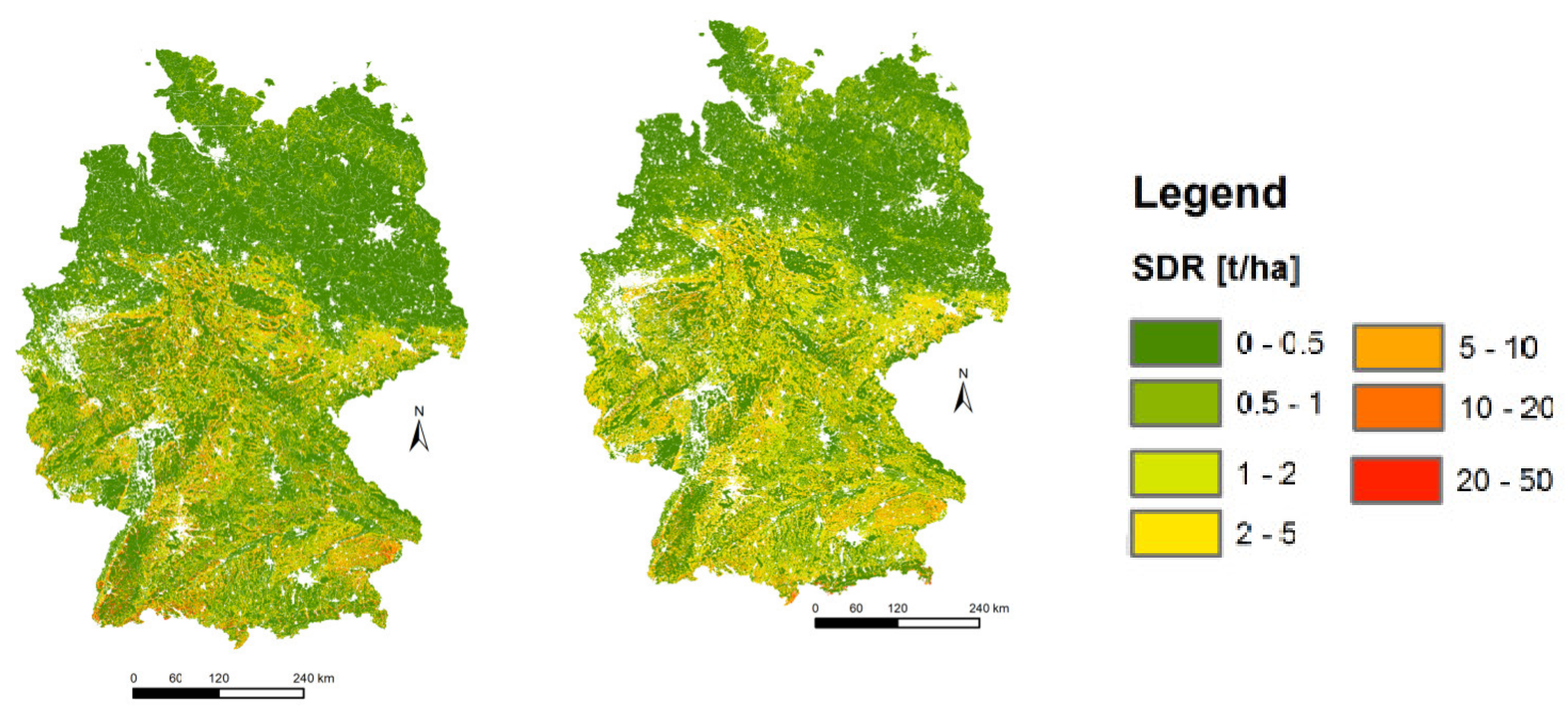
Our SDR model is calibrated with the soil erosion map that was produced by the European Soil Data Center (ES-DAC). The procedure is based on a comparison of both maps on ArcGIS. The output/results of the SDR model were brought close to the EU soil erosion map by changing the calibration parameters such as (SDRmax, C-factor, and P-factor in the Biophysical Table). Parameters such as kb and IC0 as mentioned in [26], was used to determine the relationship between hydrological connectivity (i.e., the degree of connection between land areas and rivers) and the sediment delivery ratio [27]. Figure 2-left shows InVEST SDR, while Figure 2-right is the Joint Research Center (JRC) SDR map used for calibration [28].
Figure 2. Output of the InVEST Sediment Delivery Ratio (SDR) model (left) and the Joint Research Center (JRC) map of soil loss due to water erosion [t/ha] (right), a similar pattern was observed in [29].
Energies 14 01534 g002
The WYM of the InVEST tool predicts water consumption, and values and quantifies natural water yield [30,31]. The model uses local environmental condition and land use/land cover data as an input to calculate water consumption and water yield at the watershed level. It determines annual water yield value per grid-cell by deducting water lost through evapotranspiration from the average annual precipitation during our simulation. It also calculates the value of energy that would be produced when water reaches a hydroelectric plant whereby providing economic and biophysical outputs [18].
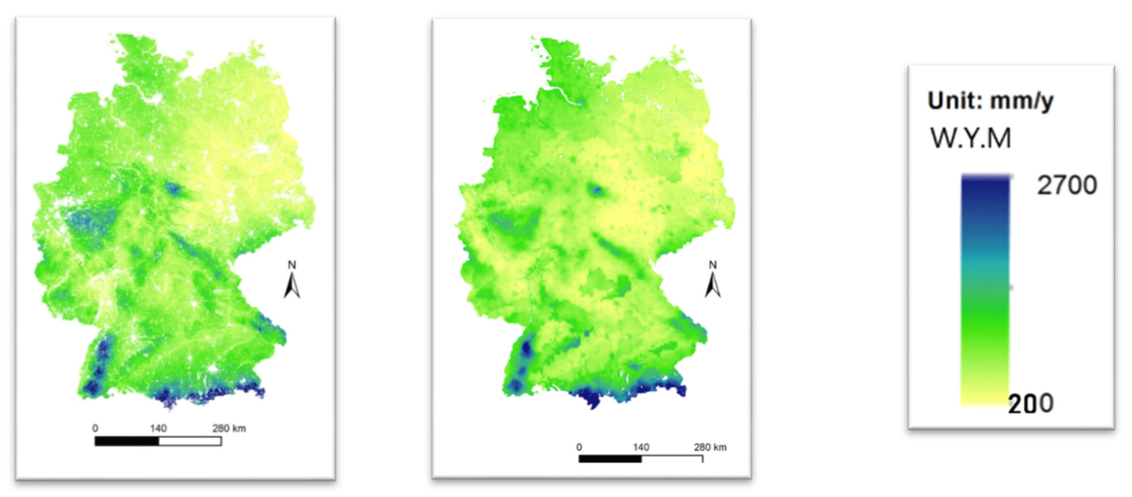
To demonstrate how well and robust our WYM works, we calibrated and compared the InVEST raster file (Figure 3 left and right). The WYM reference map adapted from JRC shows annual averages of net runoff (freshwater availability) from (1990–2010) as simulated by the LISFLOOD model. It is important to note that using only the InVEST-output map is not sufficient for the interpretation of hydrological processes or for making management decisions, hence, the need to calibrate.
One of our important calibration parameters in the WYM is the Z parameter. It is vital because of its empirical constant nature that describes the local precipitation pattern and hydrological characteristics, and the Z parameter values are typically between 1 and 30 [19]. When the Z parameter has a higher value, then the WYM will simulate a higher water yield and vice versa. In this project, the Z parameter was estimated to be 30 to accommodate the whole of Germany. Our WYM performed well, similar to what Reedhead et al. found while running WYM for 42 catchments in the UK.
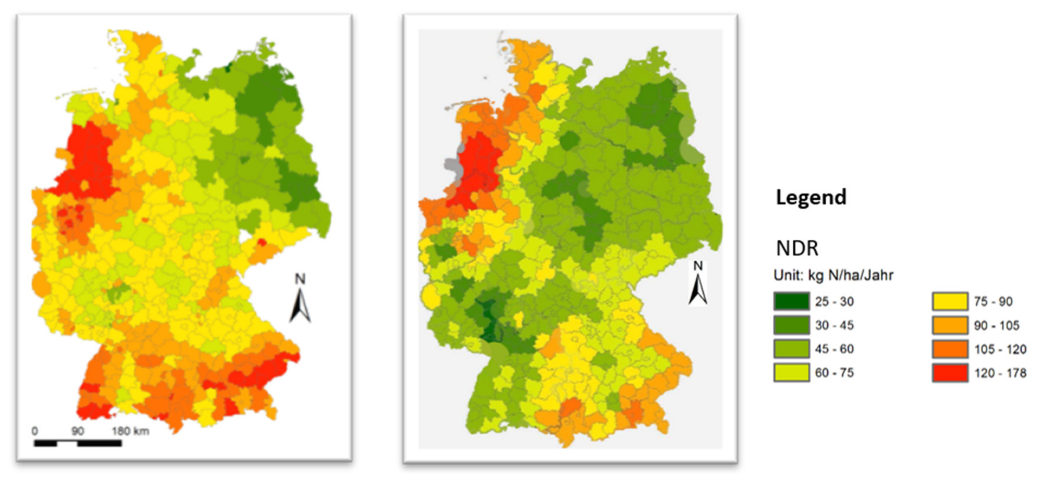
The NDR model was applied due to its ability to map nutrient sources from water catchment areas and their transport to water bodies. It uses topographic routing with movement of nutrient along the landscape to the water body. The model was rigorously calibrated with simple parameterization following [31], to cover the whole of Germany since there are different environmental conditions in different municipalities. For example, precipitation and evapotranspiration levels in the south are different from the one in the north. Calibration of our NDR model is necessary to gain confidence in the output, since the NDR factor approach is qualitative in nature and reflects change in different scenarios. A suitable literature is used as the reference map for the calibration. The calibration parameters for the NDR model are: Threshold flow accumulation, Borselli k parameter (relationship between hydrological connectivity determining factor), subsurface critical length, and subsurface maximum retention efficiency. Our InVEST map is Figure 4 (left), while Figure 4 (right) is Bach calibration model.
Figure 4. (left) The map shows an average nutrient load per hectare that reaches the river InVEST, while (right) is the nutrient balances for different regions according to [32].
Energies 14 01534 g004
Our model shows more nutrient delivery in southern Germany compared to the northern part, which could be explained by the new biogas plants built in between the research years. Moreover, the excessive use of fertilizer for maize cultivation to power the plants within a 6–7 years’ period caused the difference in both maps.

2.2. InVEST Input Data

All the input datasets were in the same cell size as required in the InVEST software, and our study used 250 m resolution for each pixel as recently updated in the global soil grids. Evapotranspiration (actual) is the function of root-restricting layer depth (The depth of the soil at which root penetration is inhibited as a result of physical constraints), land use, plant available water content (The fraction of water stored in soil profile for plant use) and reference evapotranspiration. Digital elevation model, an elevated value for each cell, a GIS raster file was refilled and rearranged for closing up the loops, eliminating sinks, and to ensure routing to a known water network [33] before running it in the InVEST suite for more accurate results. An ArcGIS mapping tool was used for viewing, organizing, and analyzing the output maps from InVEST. Further input data and clarifications are found in the Appendix A section and in the InVEST user manual.

2.3. Land Use Map Reclassification

The existing CORINE 2012 land use/land cover map was reclassified into 13 classes using the ArcGIS tool, which now includes; 1—Urban, 2—Agriculture, 3—Pasture, 4—Forest, 5—Natural Green Areas, 6—Rocky Area without Vegetation, 7—Wetland, 8—Wine, Fruits, and Berry Land, 9—Water, 11—Maize, 12—Rapeseed, 13—Wheat, 14—Soya Beans. CORINE 2012 has no information about different agricultural activities for Germany, therefore, more modifications (reclassification) in order to include the required energy crops were necessary Figure 5. This adjustment helped in easy identification of the areas that could have significant environmental impact on land due to the sitting of the new RGPs. CORINE is widely used in EU for the analysis of ES, it has a coarse scale dataset of 100 m resolution. In this study, we up-scaled to 250 m resolution, which remains appropriate for a nationwide ES assessment where data with fine-scale may likely result in computational limitations [18]. The land use map was manipulated with the R-code, and this code includes six criteria for the reclassification of the land use map in the following order; firstly, the pixels with the ideal conditions for agricultural activities were extrapolated. These pixels have been defined with the following criteria: CORINE land use map, where the slope is less than 8 and the soil texture is not the sand. The second part of the code divides the extrapolated pixels into five classes: Corn, wheat, soya beans, rapeseed, and agriculture. Note that during the reclassification, the number 10 was excluded, which is why we have land use type 1, 2, 3, 4, 5, 6, 7, 8, 9, 11, 12, 13, and 14, where 11 (maize) is the most important for obvious reasons.

3. Result

The outcome of the project saw a complete environmental evaluation of the process chains with regards to the availability and potentialities of feedstocks in order to develop strategies for the environmentally sound use of renewable energies in the gas network.
The result highlights assessed environmental consequences of alternative energy technologies on land-use, sedimentation, water, and nutrient delivery for our proposed RGPs. No retrieved literature has documented the environmental implications of our selected combinations of renewable gas plants until the year 2050 in as systematic and consistent a manner as this study.
In the obtained SDR result after the comparison and calibration, similar patterns were observed from both maps in Figure 2. This is an indication that our methods (input data and calibration) are valid for the InVEST SDR. Even though the original EU map from the JRC has a spatial resolution of 100 m, which was up-scaled to 250 m to cover the study area and for the purpose of clear comparison, the WY model reference map adapted from JRC shows annual average of net runoff (freshwater availability 1990–2010). Although the JRC map has a 5 km resolution, we are still able to observe similar patterns on both maps. That is why our model calibration result is considered as valid. Moreover, in the NDR result, similar patterns and range of loaded nutrients in median kg/hectare/year in counties was observed from the reference and our modeled maps. Nevertheless, ours showed more nutrient delivery in the south western region compared to the reference map for the non-sustainable scenario. However, there is a clear similarity in the north east (Figure 4) for both maps for the reference and current state. The EU highest nutrient export limit is about 170–180 kg N/ha/year according to [34,35]. Germany is already within the vulnerable limit zones, which is why we have modelled the nutrient to reduce its impacts to the barest minimum.
The model gave good results in terms of relative magnitude export of nutrient across different German river catchments as suggested by our output map in the sustainable scenario. Our result shows that the percentage of changes analyzed with the NDR model considering the two scenarios are lower in the sustainable scenario. For example, soya beans caused 10% change while in a non-sustainable scenario, Soya beans causes 50% change. In sustainable scenario, the energy crops and agriculture residue is less utilized by reducing the demand or the amount of maize silage needed to power the RGPs and then increasing the plant efficiency from the technical side compared to the non-sustainable scenario.

3.1. Feedstock’s with Direct Environmental Impacts

Huge tons of biomass are required to run the RGPs that have direct impact on land use change, which explains why the environmental impacts of these feedstock’s were not to be neglected from the onset. Water consumption, land occupation, and nutrient delivery especially for (maize and short rotation forestry) is important here. Moreover, the forest residue has impact on erosion depending on how many tons harvested per hectare (Table 2 [36]. Our final analysis saw a reduced amount of feedstocks from crop and forest residue in the green scenario, which is more sustainable.
Table 2. Illustrates how many tons of biomass feedstocks that can be harvested per hectares in a year for our RGPs.
RGP’s TypeBiomass per RGP
[t y−1]
Type of BiomassHarvest
[t/ha−1] Source
Bio-methane
Maize RGP:
Manure RGP:
52,414.8Maize93.3 [37]
5783.7
SNG Forest Residue:51,923.1Forest residues1.5
Syngas Forest Residue:51,923.1
SNGSRPs:52,597.4Short rotation forestry12

3.2. Nitrate Vulnerable Zones Assessment

We assessed the impacts of nitrates on ground water level and found that nutrient concentration is already very high in some German counties, therefore, there is hardly any further land potential for these areas with high concentrations, especially for sitting of maize and manure RGPs sustainably. This is because the maize and manure RGPs discharge fertilizer/manure components to the nearby water bodies, which could cause eutrophication.
Using the InVEST model, we simulated the nutrient delivery to show nutrient inputs in water to ascertain the criticality of the nitrate vulnerable zones in Germany. Results were aggregated to a municipality level in order to determine the local impact. Our model simulated high nutrient concentration in the reference state (2018) and low concentration in some municipality (Figure 6). For example, in the Bavarian region for the year 2050, there will be a reduction of nutrients, which is one of the reasons we chose this as the green scenario with less environmental impact.

3.3. Impact of Land Use Change on Erosion

We analyzed the impact of erosion using the InVEST SDR model for different scenarios and found that erosion is higher in the south compared to the north with higher disparities in some municipalities. Additionally, we modeled and calibrated our result with the existing standards. The output map shows that most areas in the southwest for (2018–2030) will expect slightly higher erosion loads in the future (>5%) (Figure 7). This erosion increase could be critical for these regions that have extremely high erosion rates already according to the German federal ministry for geosciences and raw materials.

4. Discussion

4.1. Sitting of RGPs

Locations of the RGPs is crucial for studying environmental impacts, due to diverse local environmental conditions which may include soil types, availability of feedstock, and climate conditions. In this project, locations of RGPs were carefully selected by looking for environmentally, technically, and socially balanced areas, and these drivers play key roles in the selection of the locations for new RGPs considering the existing biogas facilities in the country. The R-script program, which we used for the localization of these RGPs, is described as follows; defining pixels in the land use map that can be used for maize production; in this process, a suitable land location for maize cultivation with less impact on the ecosystem was defined and selected. The collection of forest residues (FR) and short rotation forestry (SRF) is described in Table 3 for the two different scenarios.
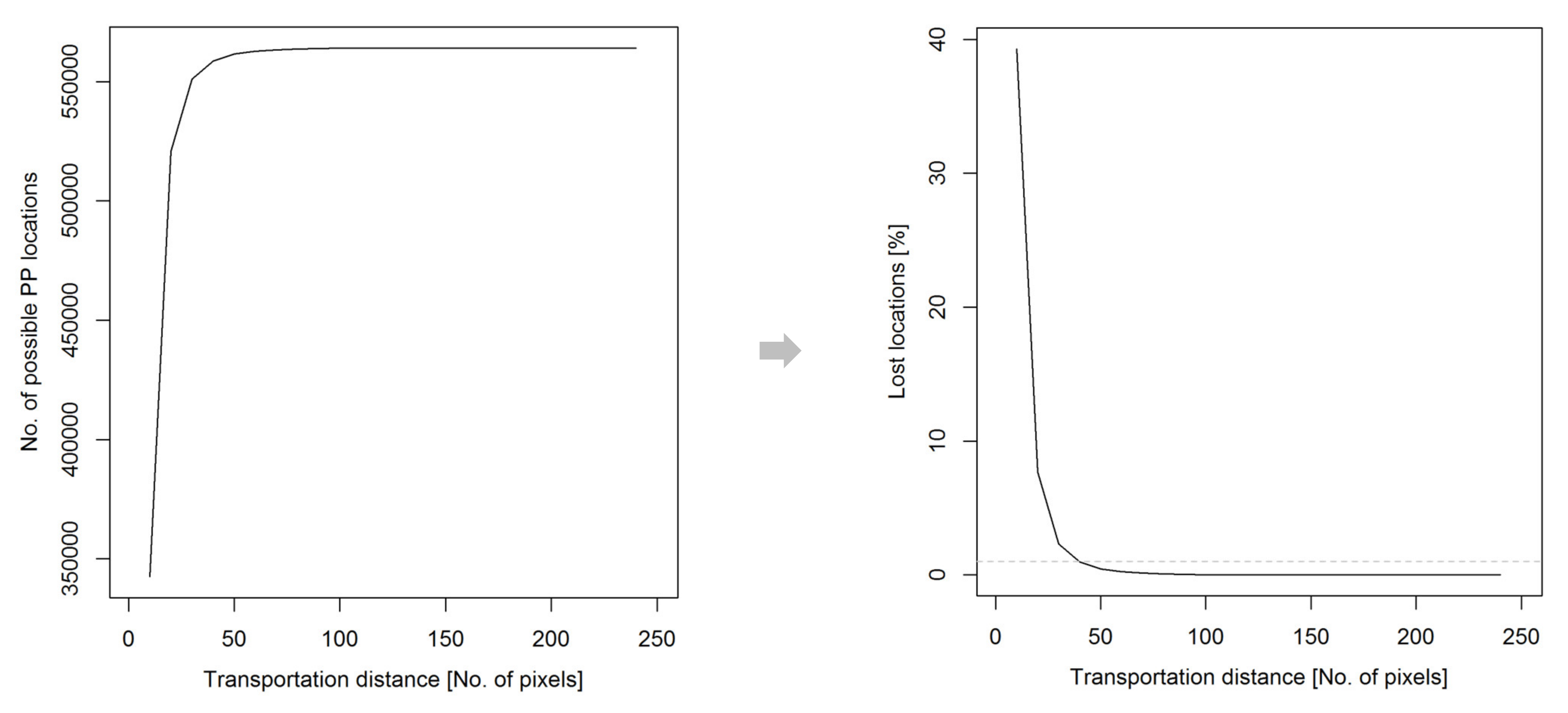
In sitting the RGPs, suitable locations were found using R-script coding, and the summary of the number of possible locations when different transportation distances were applied is represented in Figure 8. It shows that only ~3% of possible RGP locations were lost when the transportation distance of 40 pixels instead of 240 pixels is applied. These losses were regarded as insignificant. As 40 pixels represent an economically reasonable transportation distance for the maize. The transportation distance, which can also be more or longer, was shortened in order to speed up the optimization method. We have estimated that within a distance of 40 pixels, enough maize to power one RGP is produced. This is important and rigorous, especially when hundreds of locations were to be found for different types of RGPs.

4.2. Environmental Impacts of Manure

Since some of the impacts associated with a few RGPs’ feedstock could not be simulated in InVEST model (e.g., manure powered RGP), literature reviews of relevant and related publications were employed. Impacts of manure RGP considered here are water and land pollution, pest breeding ground, and offensive smell that could pose health hazard for humans around the farm. Moreover, the permissible distance limit for transport emission of 20 km round trip (10 to and 10 from RGP site) was assessed. The trip is calculated at an average of 60 km/h = (60 km covered in 60 min). This would mean transporting the manure from farm to biogas plant for 2 km in 2 min, 10 km for 10 min one way alone [38]. This 10 km distance for one way was reduced to 5 km in [39] for wet manure, with a 40-tons truck that consumes 30.53 liters of fuel per 100 km. Additionally, manure undergoes some reactions such as; fermentation, ammonia volatilization, decomposition, and nitrification. These reactions are temperature dependent, facilitated by environmental elements. The end product results in the emission of nitrous oxide, carbon dioxide, ammonia, and methane, which could be harmful to the environmental systems. Although, [40] argued that biogas facility has the tendency of reducing emissions from manure.

4.3. Modifications of Climate Data

Processing of climate data for the years 2030, 2040, and 2050 were carried out by applying the EURO-CORDEX as used in [41,42,43] in the following order; climate projections of precipitation (mm) and near-surface temperature (°C) for Germany with a spatial resolution of 0.11° (approx. 12 km) were obtained from the bias adjusted EURO-CORDEX database at the Earth System Grid Federation (ESGF). The projections are based on the Regional Climate Model SHMI-RCA4 driven by three different General Circulation Models (GCMs) under the Representative Concentration Pathway (RCP8.5): CNRM-CERFACS-CNRM-CM5 (hereafter CNRM), IPSL-IPSL-CM5A-MR (hereafter IPSL), and MPI-M-MPI-ESM-LR-MR (hereafter MPI). The three climate projections were bias adjusted by the Swedish Meteorological and Hydrological Institute (SMHI) using the Distribution-Based Scaling (DBS) approach [44] and the Regional Reanalysis MESAN (Euro4M) as the reference dataset [45]. Required inputs climate data for the InVEST model are presented in Table 4.

4.4. Recalculation of Precipitation and Erosivity Index in Steps

For precipitation, which is an important input for our InVEST model, 30-year mean annual sums were calculated for the four periods and each climate simulation (CNRM, IPSL, and MPI) (Figure 9). The Rainfall Erosivity Index was first calculated on a daily basis following Equation (1) before calculating the 30-year mean annual rainfall erosivity.
R e   =   9.6   ·   10 7 ·   P d   ·   T a 2.6
where Re is the rainfall erosivity index [MJ*mm/(ha*h*yr)], Ta daily mean temperature [°C] and Pd daily precipitation [mm];
Step 1: Monthly mean temperature was calculated from daily temperature.
Step 2: Daily daylight was obtained from different cities such as Dresden, Berlin, Leipzig, Munich, Hamburg, Hannover, Stuttgart, Bremen, etc. for the years 2009, 2010, and 2011. Differences of the length of daylight in the years 2009–2011 are only minutes. Hence, it was assumed that mean monthly hours of these three years is equal in each year in the period 1980–2018.
Step 3: A bilinear interpolation of the length of daylight to the 0.11° (12 km) climate model resolution was performed for each month.
Step 4: Mean annual Evapotranspiration (reference) was calculated for each grid point and interpolated with kriging method for all of Germany.
Step 5: 30-year mean Evapotranspiration (reference) for each period (1980–2010, 2016–2045, 2026–2055, and 2036–2065) was calculated.

5. Conclusions

There was less precipitation between the years 1980–2010 than we have now, and we will even have more wet periods in the years 2036–2065 as the climate model shows in Figure 9. This is an indication that the climate is changing, which is important to be considered before choosing energy feedstocks. SustainableGAS will contribute to German energy independence and sustainability with our proposed RGPs combination. Our final result shows that nutrient load will reduce drastically by the year 2050. This is compared to the reference state, where more maize RGP’s are in use and higher nutrients are delivered. InVEST model is a suitable tool for assessing ecosystem services in an energy project as found in this study. However, the NDR model calibration was the most difficult, due to the simple nature of the model that requires simple parameterization. The reason for this complex process is because there are different environmental conditions (different soil types, variations in rainfall patterns, etc.) across the country. Additionally, bio-methane RGP is a short-term remedy while Power to Gas and Power to Hydrogen can be long-term options in transforming the German gas sector. Although, most of the Power to X plants are not technologically ready or may still be in the pilot stage, and their environmental impacts are yet be uncovered. It is important to note that local availability of feedstock should be considered in renewable energy system analysis to avoid more ecosystem damages in the future. In general, residues, manure, and maize-powered RGP’s have been identified to play a major role in the near future and would make an impact in reaching the −40% emission reduction in the German energy sector. The sustainable scenario was finally chosen as the best environmentally acceptable development, which also suggests that environmental prosperity should be put ahead of any energy project. The scenario (sustainable) also saw a reduction of demanded biomass by 46 percent in order to create a balance between the technological demand and ecological sustainability. Additionally, CO2 price increment compared to the current rate is implemented in the selected scenario [46,47]. Since Germany is in the Nitrate vulnerable zones, it was also considered in this study to reduce eutrophication. We conclude that in the Bavarian region from the year 2050, there will be a reduction of nutrients in rivers, which is one of the reasons we chose this as the green scenario with less environmental impact. Further investigation using a life cycle impact assessment tool such as Openlca is recommended to evaluate the cradle to grave environmental impacts of our feedstock production. Lastly, changes in habitat quality by modelling the number of terrestrial or aquatic species impacted or to be affected in the future if more RGPs are built are recommended, as it is not included in this study.

Author Contributions

A.K.: Manuscript preparation, validation/updating, formal analysis, gathering of data, visualization, writing and editing. J.V.: Modeling, calibration, draft, software management. S.K.: Analysis, simulations, data curation. P.M.: Framing, correcting, methods, administration. J.K.: Framing, conceptualization. F.P.: Suggestions, supporting. R.L.: Supervision, methods, resources, conceptualization, framing, drafting, corrections. All authors have read and agreed to the published version of the manuscript.

Funding

Funding of the SustainableGAS project (https://www.sustainablegas.de/) by the German Federal Ministry for Economy and Energy (03ET4033A) is gratefully acknowledged.

Institutional Review Board Statement

Not applicable.

Informed Consent Statement

Not applicable.

Data Availability Statement

Not applicable.

Acknowledgments

Petroleum Technology Development Fund (PTDF) is recognized.

Conflicts of Interest

There are no conflicting interests.

Abbreviations

CORDEXCoordinated Regional Climate Downscaling Experiment
ESGFEarth System Grid Federation
ERErosion
ESEcosystem services
EVTEnergy/Process Engineers
GCMsGeneral Circulation Models
GEOGeographer/Environmental Professionals
GISGeographical information technology
InVESTIntegrated Valuation of Ecosystem Services and Trade-offs
JRCJoint Research Center
KoWiCommunication/Social Scientists
MWelMega Watt Equivalent of Electricity
MMeter
NDRNutrient delivery ratio
PEMProton Exchange Membrane
PtG-CH4Power-to-Methane
PtG-H2Power-to-Hydrogen
RCMsRegional Climate Models
RCP 8.5Representative Concentration Pathway
RGPRenewable gas plants
SDRSediment delivery ratio
SNGsubstitute natural gas
SOECSolid Oxide Electrolyze Cell
SRFshort rotation forestry
SynGassynthesis gas
SMHISwedish Meteorological and Hydrological Institute
TRLTechnology Readiness Level
WYMWater yield model

Appendix A

Table A1. Description of InVEST input data, data sources required for the set-up/calibration and their resolutions.
Input DataSourcesDescription
(Digital Elevation Model)
The DEM is a GIS raster file. We made sure the DEM is corrected by filling in sinks. To ensure proper flow routing which helps to determine the slope.
COPERNICUS (DEM E4030 + E4020)
http://land.copernicus.eu
Or. Resolution.:
User Res.: 250 m
(Rainfal erosivity index) GIS raster which variables depends on the duration and intensity of rainfall in a location. The higher the rain stom, the greater the erosion potentials.JRC
https://esdac.jrc.ec.europa.eu/
(Roose, 1996): http://www.fao.org/docrep/t1765e/t1765e0e.htm
Time period: 1981–2010
(Soil erodibility); K is a measure of the soil particle susceptibility to detachment and transported by runoff and rainfall. The unit index values are ton·ha·(ha·MJ mm)−1JRC: http://eusoils.jrc.ec.europa.eu/Library/Themes/Erosion/Erodibility/Data/Index.cfm (500 m resolution)Or. Res.: 500 m
User. Res.: 250 m
(Land use land cover); is a GIS raster file, the integer code is LULC for each cell (e.g., 11 = maize). It shows different land use classes of an areaCORINE 2012 Or. Res.: 1 km grids/year
User. Res.: 250 m
(river network)http://www.mapcruzin.com/free-germany-arcgis-maps-shapefiles.htm
(Precipitation) is a GIS raster dataset with a non-zero value for average annual precipitation for each cell. The precipitation values should be in millimeters.
Deutsche weather service
(https://www.dwd.de)
Or. Res.: 1 km grids/year
User. Res.: 250 m
Period: 1981–2010
Reference Evapotranspiration (reference evapotranspiration); is the potential loss of water from soil by both evaporations from the soil and transpiration by healthy plant (or grass) if sufficient water is available. The reference evapotranspiration values should be in millimeters and it is a raster dataset too.Or. Res.: 1 km grids/year
User. Res. 250 m
Period: 1991–2010
(Depth to root restricting layer); root restricting layer depth is the soil depth at which root penetration is strongly inhibited because of chemical or physical characteristics. It is a GIS raster dataset valuing each cell.German federal ministry for geosciences and raw materials (BGR)
(https://geoviewer.bgr.de/mapapps/)
Energies 14 01534 i001
Or. Res.: 250 m grid
User. Res. 250 m
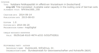
(Plant available water fraction); is the fraction of water that can be stored in the soil profile that is available for plants’ use. PAWC is a fraction from 0 to 1. Also, a raster file.German federal ministry for geosciences and raw materials (BGR)
(https://geoviewer.bgr.de/mapapps/)
Energies 14 01534 i002
Or. Res.: 250 m grid
User. Res. 250 m
(land use map)CORINE 2012Or. Res.: 1 km grids/Jahr
Benutz. Res.: 250 m
(Watersheds) Shape file; is a layer of watersheds that shows what each watershed contributes to a point of interest where water quality will be analyzed? It is a file of polygonsVigiak et al. 2012Or. Res.: 1 km grids/Jahr
user. Res.: 250 m
Biophysical table; is a csv table of LULC classes in an excel format with water quality coefficients data showing attributes of each class rather than showing individual cells in a raster maphttp://www.fao.org/geonetwork/srv/en/main.home.
Hamel P., Chaplin-Kramer,R.,Sim,S.,Mueller,C.,2015. A new approach to modelling the sediment retention service (InVEST 3.0): Case study of the Cape Fear catchment, North Carolina, USA. Sci. Total Environ. 166–177.
Table A2. Calibration data sources for InVEST.
ModelINPUT DATAData SourcesDescription
SDR(Soil erosion map)European Soil Data Centre (ESDAC), European Commission, Joint Research Centre
https://esdac.jrc.ec.europa.eu/tmp_dataset_access_req_17702#tabs-0-filters=2
Or. Res.: 100 m
user. Res.: 250 m
WYDurchschnittlicher jährlicher Nettoabfluss Water content) (1990–2010),simulated with LISFLOOD-Modell.EC-JRC LISFLOOD model output 1990–2014 (De Roo, 2014)
(Average annual net runoff (freshwater availability) (1990–2010), simulated using the LISFLOOD model.)
Or. Res.: 5 km
User. Res.: 250 m
NDRDifferent Regional NDR-ModelBach, M., 2015. Stickstoff-Bilanzierungen Notwendigkeit harmonisierter Ansätze. http://docplayer.org/64047928-Stickstoff-bilanzierungen-notwendigkeit-harmonisierter-ansaetze.htmlMunicipality
Germany 2020 energy policy review. Available online at https://www.iea.org/reports/germany-2020 (accessed on 20 January 2021).

References

  1. Aly, A.I.M.; Hussien, R.A. Environmental Impacts of Nuclear, Fossil and Renewable Energy Sources: A Review. Nuclear Energy 2000, 3, 73–93. [Google Scholar]
  2. Federal Ministry for Economic Affairs and Energy, Energy Data. 2019. Available online: https://www.bmwi.de/Redaktion/EN/Artikel/Energy/energy-data.html (accessed on 20 January 2020).
  3. Tamanini, J.; Bassi, A.; Hoffman, C.; Valenciano, J. Global Green Economy Index: Measuring National Performance in the Green Economy; United Nations: Washington, DC, USA, 2014. [Google Scholar]
  4. Pndolfi, J.M.; Connolly, S.R.; Marshall, D.J.; Cohen, A.L. Projecting coral reef futures under global warming and ocean acidification. Science 2011, 333, 418–422. [Google Scholar] [CrossRef] [Green Version]
  5. Mehdi, B.; Ludwig, R.; Lehner, B. Evaluating the impacts of climate change and crop land use change on streamflow, nitrates and phosphorus: A modeling study in Bavaria. J. Hydrol. 2015, 4, 60–90. [Google Scholar] [CrossRef] [Green Version]
  6. FNR-Agency of the Renewable Resources Fachagentur Nachwachsende Rohstoffe e.V. 2017. Available online: https://www.fnr.de/ (accessed on 15 February 2021).
  7. Thran, D.; Schaubach, K.; Majer, S.; Horschig, T. Governance of sustainability in the German biogas sector—Adaptive management of the Renewable Energy Act between agriculture and the energy sector. Energy Sustain. Soc. 2020, 10, 1–18. [Google Scholar] [CrossRef]
  8. Bouguerra, S.; Jebari, S.; Tarhouni, J. Spatiotemporal analysis of landscape patterns and its effect on soil loss in the Rmel river basin, Tunisia. Soil Water Res. 2020, 16, 39–49. [Google Scholar] [CrossRef]
  9. Bouguerra, S.; Jebari, S. Identification and prioritization of sub-watersheds for land and water management using InVEST SDR model: Rmel river basin, Tunisia. Arab. J. Geosci. 2017, 10, 34. [Google Scholar] [CrossRef]
  10. Weber, G.; Cabras, I. The transition of Germany’s energy production, green economy, low-carbon economy, socio-environmental conflicts, and equitable society. J. Clean. Prod. 2017, 167, 1222–1231. [Google Scholar] [CrossRef]
  11. Kühn, M.; Ask, M.; Juhlin, C.; Bruckman, V.J.; Kempka, T.; Martens, S. Interdisciplinary Approaches in Resource and Energy Research to Tackle the Challenges of the Future. Energy Procedia 2016, 97, 1–6. [Google Scholar] [CrossRef]
  12. Martens, S.; Hangx, S.; Juhlin, C.; Kühn, M.; Kempka, T. Energy, Resources and the Environment: Meeting the challenges of the future. 2017, European Geosciences Union General Assembly 2016, EGU Division Energy. Resour. Environ. 2017. [Google Scholar] [CrossRef]
  13. Euliss, N.; Smith, L.; Duffy, W.; Faulkner, S.; Gleason, R.; Eckles, S. Integrating estimates of ecosystem services from conservation programs and practices into models for decision makers. Ecol. Appl. 2011, 21, 128–134. [Google Scholar] [CrossRef] [Green Version]
  14. Hamel, P.; Falinski, K.; Sharp, R.; Auerbach, D.A.; Sánchez-Canales, M.; Dennedy-Frank, P.J. Sediment delivery modeling in practice: Comparing the effects of watershed characteristics and data resolution across hydroclimatic regions. Sci. Total Environ. 2017, 580, 1381–1388. [Google Scholar] [CrossRef]
  15. Walston, L.J.; Li, Y.; Hartmann, H.M.; Macknick, J.; Hanson, A.; Nootenboom, C.; Hellmann, J. Modeling the ecosystem services of native vegetation management practices at solar energy facilities in the Midwestern United States. Ecosyst. Serv. 2021, 47, 101227. [Google Scholar] [CrossRef]
  16. Piyathilake, I.D.U.H.; Sumudumali, R.G.I.; Udayakumara, E.P.N.; Ranaweera, L.V.; Jayawardana, J.M.C.K.; Gunatilake, S.K. Modeling predictive assessment of soil erosion related hazards at the Uva province in Sri Lanka. Modeling Earth Syst. Environ. 2020. [Google Scholar] [CrossRef]
  17. Bagstad, K.J.; Semmens, D.J.; Waage, S.; Winthrop, R. A comparative assessment of decision-support tools for ecosystem services quantification and valuation. Ecosyst. Serv. 2013, 5, 27–39. [Google Scholar] [CrossRef]
  18. Grafius, D.R.; Corstanje, R.; Warren, P.H.; Evans, K.L.; Hancock, S.; Harris, J.A. The impact of land use/land cover scale on modelling urban ecosystem services. Landsc. Ecology 2016, 31, 1509–1522. [Google Scholar] [CrossRef] [Green Version]
  19. Sharp, R.; Tallis, H.T.; Ricketts, T.; Guerry, A.D.; Wood, S.A.; Chaplin-Kramer, R.; Nelson, E.; Ennaanay, D.; Wolny, S.; Olwero, N.; et al. InVEST+ VERSION+ User’s Guide; The Natural Capital Project: Morges, Switzerland, 2016. [Google Scholar]
  20. Redhead, J.W.; May, L.; Oliver, T.H.; Hamel, P.; Sharp, R.; Bullock, J.M. National scale evaluation of the InVEST nutrient retention model in the United Kingdom. Sci. Total Environ. 2018, 610, 666–677. [Google Scholar] [CrossRef] [PubMed]
  21. Leh, M.D.; Matlock, M.D.; Cummings, E.C.; Nalley, L.L. Quantifying and mapping multiple ecosystem services change in West Africa. Agric. Ecosyst. Environ. 2013, 165, 6–18. [Google Scholar] [CrossRef]
  22. Terrado, M.; Acuña, V.; Ennaanay, D.; Tallis, H.; Sabater, S. Impact of climate extremes on hydrological ecosystem services in a heavily humanized Mediterranean basin. Ecol. Indic. 2014, 37, 199–209. [Google Scholar] [CrossRef]
  23. Boithias, L.; Acuña, V.; Vergoñós, L.; Ziv, G.; Marcé, R.; Sabater, S. Assessment of the water supply: Demand ratios in a Mediterranean basin under different global change scenarios and mitigation alternatives. Sci. Total Environ. 2014, 470, 567–577. [Google Scholar] [CrossRef] [PubMed]
  24. Peh, K.S.H.; Balmford, A.; Bradbury, R.B.; Brown, C.; Butchart, S.H.; Hughes, F.M.; Stattersfield, A.; Thomas, D.H.; Walpole, M.; Bayliss, J.; et al. TESSA: A toolkit for rapid assessment of ecosystem services at sites of biodiversity conservation importance. Ecosyst. Serv. 2013, 5, 51–57. [Google Scholar] [CrossRef] [Green Version]
  25. Woznicki, S.A.; Cada, P.; Wickham, J.; Schmidt, M.; Baynes, J.; Mehaffey, M.; Neale, A. Sediment retention by natural landscapes in the conterminous United States. Sci. Total Environ. 2020, 745, 140972. [Google Scholar] [CrossRef] [PubMed]
  26. Borselli, L.; Cassi, P.; Torri, D. Prolegomena to sediment and flow connectivity in the landscape: A GIS and field numerical assessment. Catena 2008, 75, 268–277. [Google Scholar] [CrossRef]
  27. Vigiak, O.; Borselli, L.; Newham, L.T.H.; McInnes, J.; Roberts, A.M. Comparison of conceptual landscape metrics to define hillslope-scale sediment delivery ratio. Geomorphology 2012, 138, 74–88. [Google Scholar] [CrossRef]
  28. JRC. Available online: http://eusoils.jrc.ec.europa.eu/Library/Themes/Erosion/Erodibility/Data/Index.cfm (accessed on 16 July 2020).
  29. Panagos, P.; Borrelli, P.; Poesen, J.; Ballabio, C.; Lugato, E.; Meusburger, K.; Montanarella, L.; Alewell, C. The new assessment of soil loss by water erosion in Europe. Environ. Sci. Policy 2015, 54, 438–447. [Google Scholar] [CrossRef]
  30. Pessacg, N.; Flaherty, S.; Brandizi, L.; Solman, S.; Pascual, M. Getting water right: A case study in water yield modelling based on precipitation data. Sci. Total Environ. 2015, 537, 225–234. [Google Scholar] [CrossRef] [PubMed]
  31. Tallis, H.; Rickets, T.; Guerry, A.; Wood, S.; Sharp, R.; Nelson, E.; Ennaanay, D.; Wolny, S.; Olwero, E.; Vigerstol, K.; et al. InVEST 3.0.1 User’s Guide 2014: Integrated Valuation of Environmental Services and Tradeoffs; The Natural Capital Project: Morges, Switzerland, 2014. [Google Scholar]
  32. Bach, M. Stickstoff-Bilanzierungen Notwendigkeit Harmonisierter Ansätze. 2015. Available online: http://docplayer.org/64047928-Stickstoff-bilanzierungen-notwendigkeit-harmonisierter-ansaetze.html (accessed on 10 January 2021).
  33. Moore, R.V.; Morris, D.G.; Flavin, R.W. Sub-Set of UK Digital 1: 50,000 Scale River Centre-Line Network; NERC: Wallingford, CT, USA, 1994. [Google Scholar]
  34. European Soil Data Centre (ESDAC). European Commission, Joint Research Centre. Available online: https://esdac.jrc.ec.europa.eu/tmp_dataset_access_req_17702#tabs-0-filters=2 (accessed on 20 March 2019).
  35. Busico, G.; Mastrocicco, M.; Cuoco, E.; Sirna, M.; Tedesco, D. Protection from natural and anthropogenic sources: A new rating methodology to delineate “Nitrate Vulnerable Zones”. Environ. Earth Sci. 2019, 78, 104. [Google Scholar] [CrossRef]
  36. Verkerk, P.J.; Fitzgerald, J.B.; Datta, P.; Dees, M.; Hengeveld, G.M.; Lindner, M.; Zudin, S. Spatial distribution of the potential forest biomass availability in Europe. Forest Ecosyst. 2019, 6, 1–11. [Google Scholar] [CrossRef]
  37. Bioenergy in Germany Facts and Figures 2019. Available online: Http://Www.Fnr.De/Fileadmin/Allgemein/Pdf/Broschueren/Broschuere_Basisdaten_Bioenergie_2018_Engl_Web_Neu.Pdf#:~:Text=Domestic%20biomass%20will%20contribute%20substantially%20to%20the%20energy,Unused%20potentials%20from%20biogenic%20residual%20and%20waste%20materials (accessed on 18 February 2021).
  38. Daniel-Gromke, J.; Rensberg, N.; Denysenko, V.; Stinner, W.; Schmalfuß, T.; Scheftelowitz, M.; Nelles, M.; Liebetrau, J. Current developments in production and utilization of biogas and biomethane in Germany. Chem. Ing. Tech. 2018, 90, 17–35. [Google Scholar] [CrossRef]
  39. Aracil, C.; Haro, P.; Giuntoli, J.; Ollero, P. Proving the climate benefit in the production of biofuels from municipal solid waste refuse in Europe. J. Clean. Prod. 2017, 142, 2887–2900. [Google Scholar] [CrossRef]
  40. Strzalka, R.; Schneider, D.; Eicker, U. Current status of bioenergy technologies in Germany. Renew. Sustain. Energy Rev. 2017, 72, 801–820. [Google Scholar] [CrossRef]
  41. WCRP CORDEX Coordinated Regional Climate Downscaling Experiment. Available online: https://cordex.org/ (accessed on 14 February 2021).
  42. ClimEx Project. Available online: https://www.climex-project.org/ (accessed on 14 February 2021).
  43. Von Trentini, F.; Leduc, M.; Ludwig, R. Assessing natural variability in RCM signals: Comparison of a multi model EURO-CORDEX ensemble with a 50-member single model large ensemble. Clim. Dyn. 2019, 53, 1–17. [Google Scholar] [CrossRef] [Green Version]
  44. Yang, W.; Andréasson, J.; Graham, L.P.; Olsson, J.; Rosberg, J. Wetterhall, F. Distribution-based scaling to improve usability of regional climate model projections for hydrological climate change impacts studies. Hydrol. Res. 2010, 41, 211–229. [Google Scholar] [CrossRef]
  45. Häggmark, L.; Ivarsson, K.I.; Gollvik, S.; Olofsson, P.O. Mesan, an operational mesoscale analysis system. Tellus A Dyn. Meteorol. Oceanogr. 2000, 52, 2–20. [Google Scholar] [CrossRef] [Green Version]
  46. Kolb, S.; Plankenbühler, T.; Pfaffenberger, F.; Vrzel, J.; Kalu, A.; Holtz-Bacha, C.; Dillig, M. Scenario-Based Analysis for the Integration of Renewable Gases into the German Gas Market. In European Biomass Conference and Exhibition Proceedings; Grassi, A., Carvalho, M.D.G., Helm, P., Scarlat, N., Eds.; ETA-Florence Renewable Energies: Lisbon, Portugal, 2019; pp. 1863–1868. [Google Scholar]
  47. Kolb, S.; Plankenbühler, T.; Frank, J.; Dettelbacher, J.; Ludwig, R.; Karl, J.; Dillig, M. Scenarios for the integration of renewable gases into the German natural gas market–A simulation-based optimisation approach. Renew. Sustain. Energy Rev. 2021, 139, 110696. [Google Scholar] [CrossRef]
Figure 1. Project workflow showing each partner’s responsibility at a glance.
Energies 14 01534 g001
Figure 3. (left) InVEST water yield model (WYM)—resolution 250 m, (right) JRC water yield reference map from LISFLOOD model—resolution 5 km.
Energies 14 01534 g003
Figure 5. Reclassified land use map to include the agricultural land use vital for energy feedstock’s needed in our RGPs. Our reclassified map shows more maize in the west where our new maize RGPs can be suitably located.
Energies 14 01534 g005
Figure 6. NDR (nutrient deliver ratio) (NO3 [t/ha] a) result for current state 2018—left (high) and future 2050—right (low) scenario on nitrates concentration in tons per hectare at municipality level as simulated by our model. The green arrows in the map show how nutrient delivery will decrease in the year 2050. The northwest will experience lower nitrate loads as well as the south in 2050 compared to the current situation, and the same is applicable in the eastern part of the country. This is explainable as the RGPs powered with maize will automatically switch off (when it is no more cost effective and environmentally safe), while the ones powered with water and electricity will strive more starting from the year 2045 upwards when they are more technologically ready and affordable.
Energies 14 01534 g006
Figure 7. German erosion potentials by municipalities in tons per hectare per annum, according to the German federal ministry for geosciences and raw materials before our reference state.
Energies 14 01534 g007
Figure 8. Transportation distance vs. number of possible locations for new RGPs (left) percentages of lost locations (right). Note that the dotted lines signify about 3% lost location. Note: When the transport distance is 50 km, 350,000 possible location for new RGP is found which is the shortest. While 250 km transport distance produces 550,000 new RGP’s potential location.
Energies 14 01534 g008
Figure 9. Precipitation [mm] for three different climate projections for four time periods (dark color means high, light color means low). For the interpretation of the numbers on the X axis, 5400000 = 54,000.00, 5600000 = 56,000.00, 5800000 = 58,000.00, 6000000 = 60,000.00
Energies 14 01534 g009
Table 1. Renewable Gas Plant (RGPs) combination with their feedstock’s impact and plant size.
Possible ImpactsRGP (Conversion) TypeRGP Name and Size (MW1)Substrate
Land use change, nutrient delivery (ND), waterBio-methane Biomethane maize (10)Maize silage
Odour/H2O pollution, pestBiomethane manure (2.5)Manure/maize
Good biomassBiomethane residues (10)Food residues
Regional impactSNG (substitute natural gas) Heat Pipe Reformer
(HPR) technology
HPR imported pellets (1)Imported wood pellets
NegligibleHPR straw (1)Straw
Land Use Change/sedimentationSNGforest residues (30)Forest residues
ND and ErosionSRP (30)Short rotation plantations
Low without tree cuttingSynthesis gas (SynGas)SynGas forests
Residues (30)
Forest residues
Regional impactGasifier with Absorbent Enhenced ReformerImported pellets (100)Imported wood pellets
Medium water use Power-to-Methane catalyticPower-to-Methane
Catalytic (6)
Electricity + water
Medium water usagePower-to-Methane biologicPower-to-Methane
Biologic (1)
Electricity + water
HighPower-to-Hydrogen SOECPower-to-Hydrogen
SOEC (0.1)
Electricity + water
CH4 emissionPower-to-Hydrogen partial stream methane reform (SMR)Power-to-Hydrogen
Steam Reformer (0.5)
Electricity + water + methane
HighPower-to-Hydrogen Proton Exchange Membrane (PEM) electrolysisPower-to-Hydrogen
PEM (1)
Electricity + water
Table 3. Selected pixels from the land use map which can be suitable for maize and for the short rotation forestry production in the sustainable scenario are 2, 11, 12, 13, 14. While for the collection of forest residues, only land use type 5, which is the natural green area, is suitable.
Non-SustainableSustainable
Type of RGPBiomethane Maize/ManureSNG F.ResidueSNGShort Rotation.FBiomethane Maize/ManureSNG F.ResidueSNGShort Rotation.F
BiomassMaizeFRSRFMaizeFRSRF
LUC, which can be used for growing biomass2, 4, 6, 11, 12, 13, 1452, 4, 6, 11, 12, 13, 142, 11, 12, 13, 1452, 11, 12, 13, 14
Slope<5°/<5°<5°/<5°
Soil texture2, 3, 4, 5, 6, 7, 8, 9, 10//2, 3, 4, 5, 6, 7, 8, 9, 10//
Protest Atlas1, 2, (3)/1, 2, (3)1, 2, (3)/1, 2, (3)
Note: For the land use reclassification, each number in Table 3 represents a land use type for easy understanding: 1—Urban Area, 2—Agriculture, 3—Pasture, 4—Forest, 5—Natural Green Areas, 6—Rocky Area without Vegetation, 7—Wetland, 8—Wine, Fruits, and Berry Land, 9—Water, 11—Maize, 12—Rapeseed, 13—Wheat, 14—Soya Beans. For the protest atlas, 1 means high while 3 means low acceptance.
Table 4. Input climate data used in our InVEST model.
Climate Data—Input
NDR- Precipitation [mm]
SDR- Rainfall Erosivity Index [MJ*mm/(ha*h*yr)]
WYM- Precipitation [mm]
- Reference evapotranspiration [mm]
Publisher’s Note: MDPI stays neutral with regard to jurisdictional claims in published maps and institutional affiliations.