Article

The Development of Decarbonisation Strategies: A Three-Step Methodology for the Suitable Analysis of Current EVCS Locations Applied to Istanbul, Turkey

1
Civil Engineering Department Erzurum, Engineering and Architecture Faculty, Erzurum Technical University, 25050 Erzurum, Turkey
2
Faculty of Engineering and Architecture, Kore University of Enna, 94100 Enna, Italy
3
Department of Civil Engineering, Faculty of Engineering, Atatürk University, 25100 Erzurum, Turkey
*
Author to whom correspondence should be addressed.
Energies 2021, 14(10), 2756; https://doi.org/10.3390/en14102756
Submission received: 25 March 2021 / Revised: 9 May 2021 / Accepted: 10 May 2021 / Published: 11 May 2021
(This article belongs to the Special Issue Integrated Energy Systems and Transportation Electrification)

Abstract

:
One of the solutions to reduce environmental emissions is related to the deployment of electric vehicles (EVs) with sustainable energy. In order to be able to increase the number of electric vehicles in circulation, it is important to implement optimal planning and design of the infrastructure, with particular reference to areas equipped with charging stations. The suitable analysis of the location of current electric vehicle charging stations (EVCSs) is the central theme of this document. The research focused on the actual location of the charging stations of five major EVCS companies in the province by selecting Istanbul as the study area. The study was conducted through a three-step approach and specifically (i) the application of the analytical hierarchy process (AHP) method for creating the weights of the 6 main and 18 secondary criteria that influence the location of EVCSs; (ii) a geospatial analysis using GIS considering each criterion and developing the suitability map for the locations of EVCSs, and (iii) application of the technique for order preference by similarity to ideal solution (TOPSIS) to evaluate the location performance of current EVCSs. The results show that the ratio between the most suitable and unsuitable areas for the location of EVCSs in Istanbul and the study area is about 5% and 4%, respectively. The results achieved means of improving sustainable urban planning and laying the basis for an assessment of other areas where EVCSs could be placed.

1. Introduction

The growing demand for transport in the world has recently been the subject of numerous studies aimed at improving modal choices and reducing environmental and socioeconomic impacts. A great deal of energy (non-renewable energy) is consumed in the course of transport activities. In 2016, global energy consumption rates recorded a 26% share related to transport sector [1,2].
Their GHG impact is about 16.2% [3]. By 2020, these rates have risen to 20.6% with a further increase forecast [4,5].
Recently, the COVID-19 pandemic has changed transport choices in many countries by reducing the public transport choice due to social distancing and possible contagion. Overcoming the negative environmental impacts is a major challenge.
All nations have put in place a number of strategies to reduce environmental pollution and climate change. Various protocols and agreements have been made on an international scale to determine the responsibilities of all countries in the fight.
The Kyoto Protocol, the Montreal Protocol, and the Paris Agreement are examples of such agreements [6,7]. Furthermore, in the European Union’s “Green Deal” programme, the aim is to reduce the European GHG to zero by 2050 [8].
The 2030 Agenda includes issues that UN member states have to implement on climate change until 2030 [9]. Moreover, in recent years, some studies of new technologies and applications have been conducted to reduce environmental pollution caused by the transport sector. These are generally referred to as sustainable transport practices.
The most important of these applications are electric vehicles (EVs) [10] car-sharing service [11], encouragement of public transport [12], bicycle use and sharing [13], e-scooter diffusion, congestion pricing [13,14,15,16], as well as electric drones (used as delivery vehicles in light freight transportation) [17,18]. In addition to the implementation of sustainable planning, the post-pandemic transport sector will also need to be resilient in order to quickly mitigate possible criticalities related to a future pandemic or catastrophic events [14,15]. Several studies confirm that the increase of electric fleets and the abandonment of combustion engine vehicles will bring benefits and can be an easily implemented strategy [16]. The spread of electric vehicles will make an important contribution to the process of decarbonisation, which is an important step in the fight against climate change [8]. Electric vehicles have advantages in terms of both environmental and noise pollution. Currently, electric vehicles also have some disadvantages such as range, charging time, and lack of infrastructure [19]. This situation shows that electric vehicles are more suitable for urban use. The biggest obstacle to increasing the use of electric vehicles in cities is the lack of charging infrastructure (EVCS). Unlike combustion-powered vehicles, electric vehicles can be recharged while parked, although a certain amount of charging will always be needed en route. It is, therefore, useful to help the deployment of charging infrastructure to bring value to all stakeholders, increasing the usability reducing costs, and in particular considering the following:
  • Drivers will benefit from convenient and timely charging, and decreasing waiting time;
  • Optimal location of the charging station will also result in lower charging costs;
  • The operators of the charging points will achieve higher and more predictable use of their resources and lower network connection costs;
  • Investors receive higher returns on their investments and reduced risk;
  • Distribution system operators will have a better prediction of the likely distribution of charging infrastructure on their system and the resulting load, allowing them to improve their network investments;
  • Utilities/aggregators will be able to offer more valuable services to their customers and the network if more vehicles are connected more often;
  • Car manufacturers will also have a better forecast of the likely distribution of chargers and will have more satisfied EV customers and optimal e-mobility related services leading to more EV sales.
An effective methodology for reducing this bottleneck will have to take several criteria into account and will have to consider current possibilities and limited budgets. Such a methodology should evaluate several criteria and analyse the location of these areas by means of geospatial analysis, selecting the most suitable areas.
The multicriteria approach makes it possible to investigate different main and secondary factors that may influence the implementation of EVCSs. A multicriteria approach was carried out by basing it on a geographical information system and investigating the location of existing recharge areas. In recent years, this approach is used in several areas.
The study aims to promote a methodology that allows for a better diffusion of electric vehicle recharging areas by minimising disadvantages and examining the current situation and the related problems related to the general diffusion of electric vehicles, recharging time, infrastructure efficiency, etc. From the first methodological phase of determining the criteria and their weights, the second phase consisted of geospatial analysis using GIS and the creation of suitability maps from which the performance scores of the current EVCSs were obtained, and the process of evaluating the stations was carried out using the TOPSIS technique, as described in Figure 1.

2. Literature and Methodological Review

The sustainability of mobility systems is one of the recent topics that allow us to investigate different forms of mobility by promoting those that allow a lower environmental and psychosocial impact.
The use of green forms of energy instead of traditional fuels, the spread of shared mobility (shared mobility or demand responsive transport) for medium-long distances, and walking for short distances can be low impact choices to be implemented in the coming years in compliance with the concept of decarbonisation.
The study of e-mobility and infrastructure is a charging theme linked to numerous researches that aim to improve the service and infrastructure and increase demand through a bottom-up approach, i.e., by investigating the population and analysing the criticalities related to the implementation of an e-mobility system.
The spread of electric vehicles in their various technological forms will, in the near future, be one of the key measures to reduce air pollution, especially in urban areas. The COVID-19 pandemic has led to the need to rethink public spaces and transit areas. The design of multimodal transit areas and public transport stations is one of the priorities of the city of Istanbul, an area investigated in this paper. In Istanbul, the number of private car trips was 4.2 million in 2009, and it is expected to reach 11.1 million in 2023 due to the increase in car ownership. In addition, the demand for public transport is lower than in other developed countries [20]. Some government actions can encourage the use of public transport by reducing car dependency. An improvement in terms of environmental impact is produced by the introduction and subsequent increase of electric vehicles in public and private transport fleets. Research on shared mobility in Istanbul shows that it is necessary to improve the infrastructure and services for both bike and car sharing. At the same time, the introduction of demand-responsive mobility (DRT) could discourage the use of private cars, especially in areas with low transport demand. The electrification of these modes of transport, therefore, could further improve the fluidity of vehicular traffic and require improved recharging areas. The creation of a reliable electric recharging infrastructure with a sufficient presence in the city context is vital to the massive deployment of electric mobility, both in its physical and ICT aspects. Moreover, the current autonomy limits of the purely electric vehicle (PEV) are well suited to its use in the urban context: there is in fact a strong presence of users with low daily mileage (home–work trips, typically within 10–20 km per day) that could convert to electric mobility if the following important conditions are met:
  • Availability of charging points other than home charging on private and public land (public and company car parks, supermarkets, railway stations, traditional service stations that have also been converted to electric mobility) with the possibility of slow and fast charging;
  • Availability of multistandard charging systems open to different suppliers;
  • Encouraging actions by local authorities (free parking, exemption from road pricing systems, use of reserved lanes);
  • State encouragement (economic incentives, tax exemptions).
Several factors contribute to the plan and design of an electric mobility service and infrastructure; therefore, several studies in the literature focus on multicriteria analysis.
The location and characteristics of the charging stations must meet several requirements: they must logistically significant locations, but they must also be connected to a distribution network node that is adequate to meet power. In suburban areas, a distance criterion is generally assumed (the maximum distance between two charging stations must be kept within fixed limits). Rational urban planning should allow the optimisation of the position and relative “size” or energy commitment of charging stations. The problem of how to deal with the lack of charging infrastructure is much discussed in the scientific literature, in which the presence of strategic errors in infrastructure planning is often detected. The use of MCDA multicriteria analysis based on GIS data for the identification or characterisation of sites has been reflected in several studies in the literature. The present study applies these investigation steps to the dislocation of EVCSs. In particular, Feng et al. combined the MCDA method and the linguistic entropy weight (LEW) method to evaluate the optimal position of EVCSs in the Chengdu Region, considering 5 main criteria and 13 subcriteria. LEW method was applied for weighting criteria, while the axiomatic fuzzy design method was applied for the selection of the best position of 12 alternative EVCSs. This study was performed due to a sensitivity analysis conducted to test the accuracy and effectiveness of the study [21].
In the study conducted by Wu et al., 5 main criteria and 16 subcriteria were included in the site selection study of six potential EVCSs for dense residential communities in the Beijing Region. While triangular intuitionistic fuzzy numbers were used to weigh the criteria, a fuzzy “Vlsekriterijumska Optimizacija I Kompromisno Resenje” (Fuzzy-VIKOR) approach was used in the EVCS evaluation process [22]. Erbaş et al. evaluated 12 current and alternative EVCSs in the Ankara Province, the capital of Turkey. For this process, 3 main data frames and 15 subcriteria were created. The criterion weighting process was performed with fuzzy AHP and TOPSIS was used to evaluate EVCSs [19]. Gan et al. examined the genetic algorithm of fast charging stations distribution by efficiently determining the optimum locations of fast charging stations and considering the charge demand in a stochastic manner [23].
Kabak et al. studied the selection of the site where bike-sharing stations are a means of transport that can be a solution to traffic congestion and environmental concerns. GIS-based MCDA methods were used to compare current and alternative bike-sharing stations for Izmir, considering 3 main criteria and 12 subcriteria [24]. Lin et al. evaluated sharing stations in the Beijing Region for car-sharing services, which they consider effective support for public transport. Eight criteria that influence the location of the stations were considered. Evaluation of five candidate stations planned to be located in public transport areas was performed with extended MULTIMOORA [25].
Today, site selection has continued in a popular way. Due to energy consumption and environmental concerns, sustainable transportation practices have been frequently included in studies in recent years. Examining the monitored site and selecting the relative sustainable parameters and criticalities, the research considers the sub-criteria defined in Table 1.
Nevertheless, the planning of recharging infrastructures must necessarily take into account a number of constraints (such as the interaction of such infrastructure with the territorial electrical system, the actual conformation of the territory, national and the actual shape of the territory, national and EU electricity policies, etc.).

3. Materials

Mathematical, statistical models, MCDA techniques, and optimisation methods have been generally used in the current studies on site selection. However, only using these methods/techniques in site selection studies conducted is considered insufficient. In the aforementioned studies, using programmes that provide capability spatial analysis and MCDA methods together provides an effective solution.
Some studies conducted with the GIS-based MCDA approach are references [38,39]. Lack of spatial analysis in EVCS site selection problems and not detailed analysing the current situation is a big gap.
This study aims to fill this gap in EVCS site selection studies. For this, the GIS-based MCDA approach was preferred in the location assessment of current EVCSs. Since evaluating station location is a site selection problem, many criteria should be taken into account. In this study, while AHP and TOPSIS from MCDA methods were used, ArcMap 10.6 software was used for geospatial analysis.
The contribution of the study to the literature is given below.
  • GIS-based MCDA approach was proposed to determine the performance values of current EVCSs. Thus, the lack/need of spatial analysis in the studies in the literature was eliminated.
  • When previous studies are examined, it is observed that the evaluation criteria are limited. However, the locations of EVCS in charging service are directly related to multiple factors such as energy, environment, transportation, economic and geographic. A comprehensive criterion pool was created for being the correct of EVCSs’ performance evaluation in this paper.
  • As the novelty of the study, the current infrastructure of electric vehicles, which is the most popular transportation application, is examined both sectorially and scientifically.
  • The number of stations considered in earlier studies is quite low. This situation indicates that the study area is not analysed completely, and the station analyses are not valid. Therefore, the accuracy and validity of the performance evaluation of all EVCSs (including individual EVCSs) were provided by analysing the metropolitan city such as Istanbul as a whole.
  • The biggest obstacle to the dissemination of EVs is undoubtedly the charging infrastructure. By examining the suitability map, it can be ensured that current stations are used effectively with the relocation of the stations in unsuitable areas to the most suitable areas.
  • This study is a guideline for current and potential service providers with the determination of the most suitable areas for EVCS locations.
  • Suitable areas will be classified among themselves in the suitability map. Thus, being testable of the station evaluation will be ensured.

3.1. Study Area

Istanbul has one of the largest populations in Turkey; in fact, it is ranked in the top 15 in the world in terms of population [40]. Due to the high population, mobility in the city is quite high. There are 4,187,776 motor vehicles in Istanbul and constitute approximately 20% of the number of motor vehicles in Turkey [41].
This situation has very devastating consequences for the environment and traffic. Istanbul ranks the first city in Turkey and 26th in the world in terms of carbon footprint [42]. It is possible to solve environmental impacts and traffic problems under the same denominator with sustainable transportation practices. In the automotive industry, there has been a great trend towards EVs in the last decade.
However, the amount of EVs sales in Turkey are not conducting a parallel process with the world. The main reason for this is insufficient charging infrastructure.
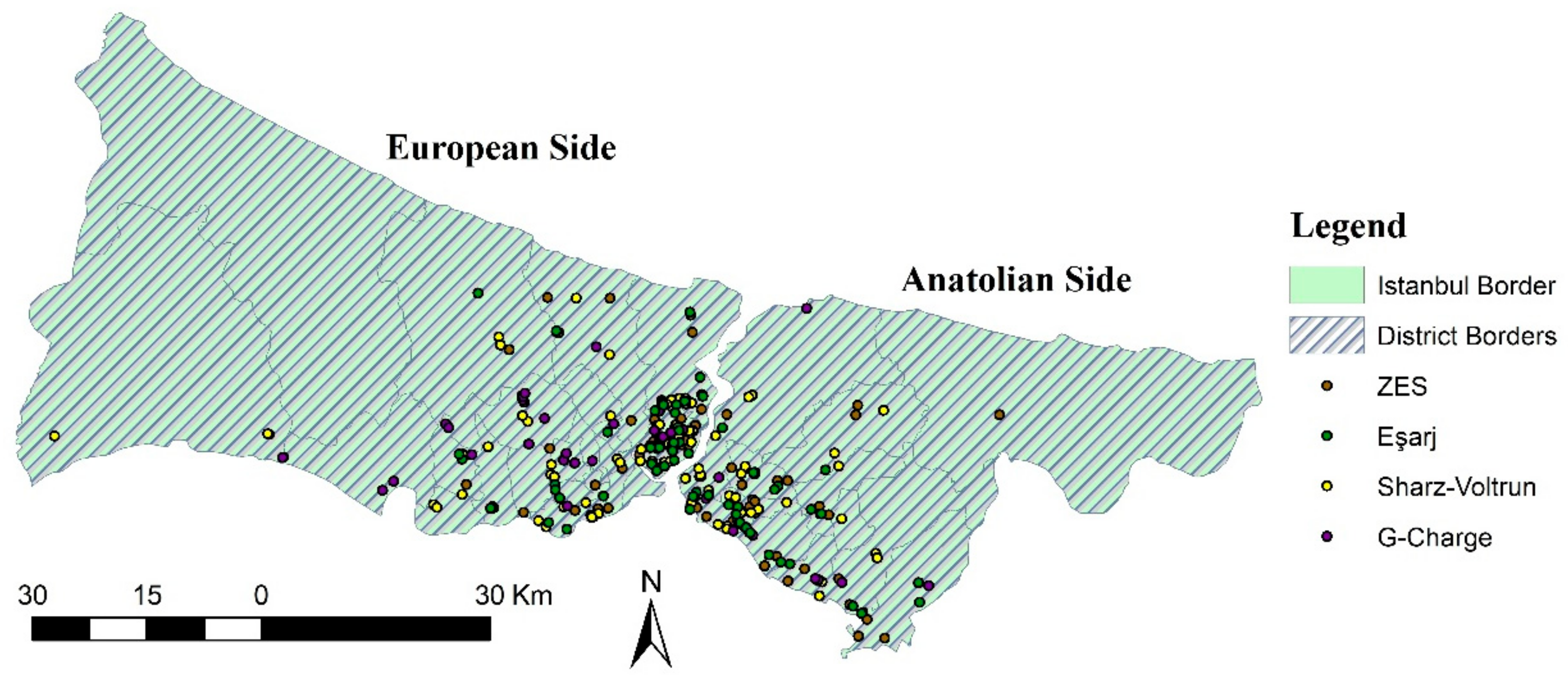
Although Istanbul is the province where EVCSs are most operated, there are only 294 stations (most of them for individual and restricted usage). Current EVCSs may meet the needs of existing EVs, but it is clear that this number will be insufficient with the transition of conventional vehicles to EVs and the increase in the number of EVs. Furthermore, many of the current EVs in Turkey are located in Istanbul such as those shown in Figure 2 below.
Therefore, in this study, Istanbul was selected as the study area and the charging station locations of five EVCS companies in Istanbul were evaluated. The study area is presented in Figure 3.

3.2. Some Considerations on the Economics of Recharging Electric Vehicles in Turkey

Over the years, numerous charging stations have been deployed in Istanbul as well as in other large cities such as Izmir and Ankara. Currently, 1169 electric vehicles and 582 charging stations have been registered in Istanbul, but this number is set to increase. Local governments and industries predict an almost 30% increase in electric vehicle sales by 2030 in order to ensure global decarbonisation targets.
From an infrastructural point of view, it is found that in some cities of Turkey, the parking spaces and EV charging spaces are located between municipal parking lots and between private ones. In addition, many shopping centres have charging stations within their car parks and near places of attraction such as hotels, schools, etc.
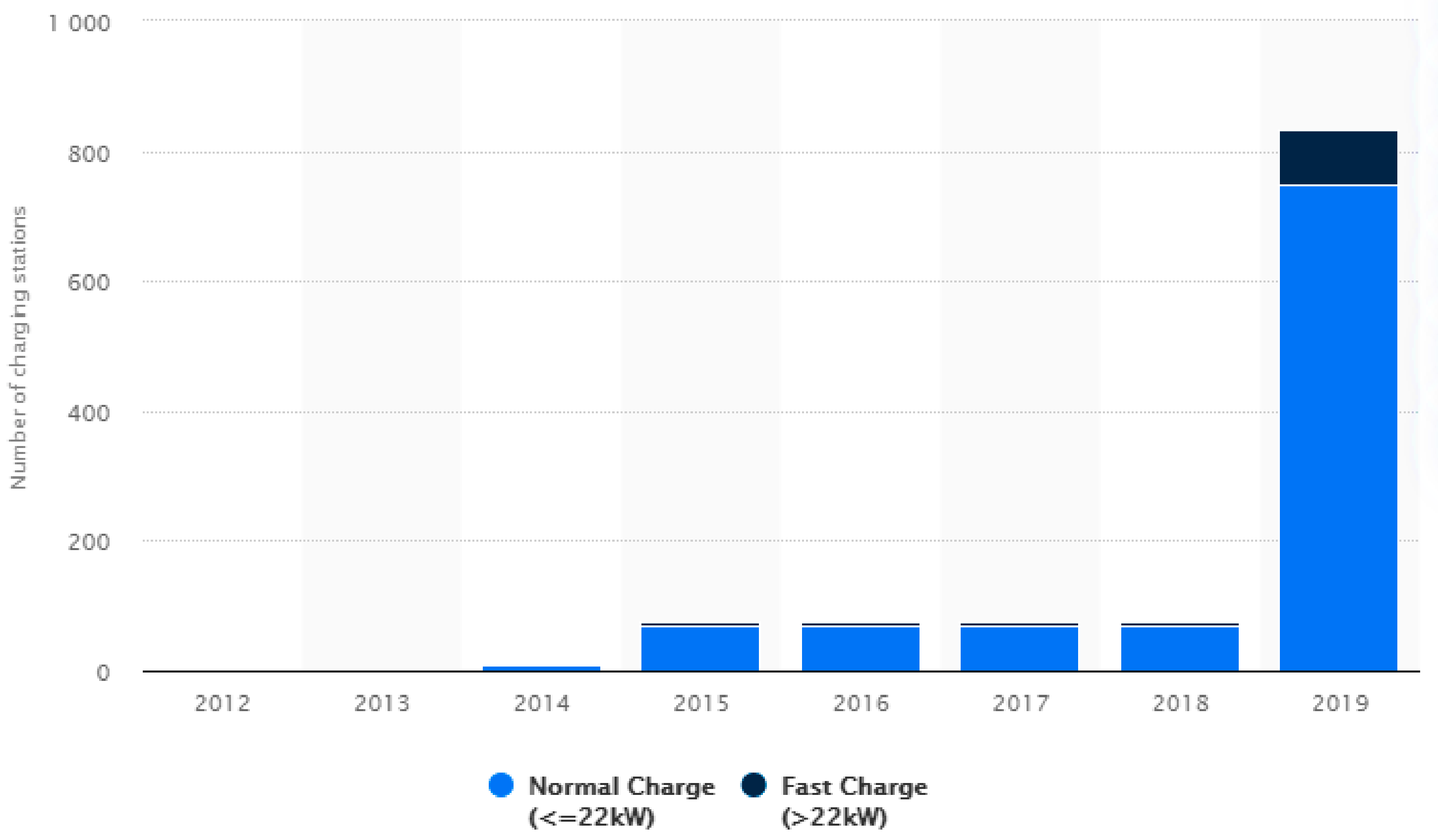
Figure 4 represents the number of EVCSs in Turkey. Some studies have also focused on Turkey’s nuclear energy policy as an alternative to the country’s rapidly increasing electricity consumption [43].
Therefore, the following is a brief analysis of the cost of charging to the user and then the cost of implementing charging stations.
In particular, a brief comparison between countries shows that the cost in Turkey is among the lowest, as defined in Table 2.
To calculate the cost of charging electric vehicles, average electricity charges per kWh were obtained from the World Bank. For Tesla Model S, charging costs have been found considering the maximum battery capacity. It is then divided by 405 (Tesla Model S’s range) to obtain the costs in miles. Electric vehicles should be placed within the 30, 35, 40, 45, and 50 km range depending on infrastructure conditions [45]. This paper shows that the national average for installing a standard EVCS ranges from US Dollars (USD) 456 to USD 1072, while the median cost is USD 760 each. The prices of the stations alone range from USD 400 to USD 2000, depending on whether a level 1 or level 2 is chosen. An EVCS costs USD 750 or USD 250 to USD 1900. An EVCS, a type of electric vehicle power equipment (EVSE), is available in both portable plug-in styles and direct-wire units.
Recently, a new action plan, including tax incentives, was announced by the government to encourage the use of electric vehicles in Turkey [47].
The obstacles to the use of EVs for users are as follows:
  • Charging stations—Charging station infrastructure is not disseminated throughout the country;
  • Legislation—There is no needed legislation on the use of EVs in Turkey and there is still more uncertainty on this issue;
  • Taxes—Taxes on vehicles are quite high in Turkey. Although there is a tax incentive in EVs, the purchase cost is still not at acceptable levels;
  • Promotion—Potential users are not provided with enough information about EVs.
Several research studies focused on defining the knowledge gaps, barriers, and opportunities in the development of charging infrastructure were identified and analysed by some scientific works promoting the development of public charging infrastructure and analysing more the impacts of customers’ psychological factors and on the technical development of charging infrastructure and EV batteries. Government supports have been shown to be important for EVs. Therefore, more attention should be paid in terms of the incentives and recommendations of government policies on charging infrastructure problems. Additionally, charging cost is an important factor to be considered in the planning process of charging infrastructure [48,49].

3.3. Definition of Criteria

The criteria affecting the performance evaluation of EVCS locations were determined with the help of the literature and the advisory board consisting of academicians/experts.
Academicians refer to the authors of the paper, and experts refer to charging station service providers and transportation engineers who are experts in their fields.
The determined evaluation criteria were categorised under six main headings, based on the recommendations of the advisory board, and consist of 18 sub-criteria in total. Thus, a large criteria pool is obtained for the evaluation of EVCS locations.
While 16 criteria are used in the spatial analysis process, all criteria are included in the performance evaluation of the stations.
The purpose of use, data source, brief explanations, and the spatial analysis types applied are given in Table 3. Comprehensive information on the criteria can be found in this table.
Some of the criteria have also been used in previous studies. However, other criteria were used for the first time in this study by considering the opinions of experts and authors. Literature sources of the criteria used in the study are presented in Table 3. The criteria used frequently in the literature have been proven their usability and suitability in EVCS site selection studies.
The most used criteria in the site selection of EVCSs are generally population, road networks, and parking areas.
Thus, a comprehensive framework with 18 sub-criteria was created for the performance evaluation of EVCS.

4. Methods

Several simulations were carried out comparing the results obtained after the appropriate calibration and data processing steps. In recent years, GIS and/or MCDA methods have been used frequently in solving site selection problems.
Since the process of determining and evaluating the locations of EVCSs is a site selection problem, the GIS-based MCDA approach was used in this study. AHP is preferred for the criteria weighting process, while the TOPSIS method is used in ordering decision alternatives. Geospatial analysis of the criteria was carried out via GIS. Brief descriptions of these methods are mentioned in this section.

4.1. Analytical Hierarchy Process (AHP)

Thomas Saaty developed AHP in 1977 for the solution of complex problems with multiple criteria [62]. In other words, Saaty defined AHP as a linear weighted method [63]. To implement this method correctly, a hierarchical structure must be established. This structure consists of the purpose, main criteria, and subcriteria in the decision-making process. AHP has many advantages besides its ease of application. Readers can access detailed information about these advantages from Refs. [64,65]. AHP is frequently used in many areas such as transportation, energy, environment, and management [66,67,68,69,70,71,72,73]. In comparing the decision alternatives, each criterion was evaluated separately, and pairwise comparison matrices were created. It is necessary to perform n n 1 / 2 comparisons when there are n elements. The Satty [1,2,3,4,5,6,7,8,9] scale is used in pairwise comparison matrices [74]. As a result of these matrices, criterion weights are obtained and the consistency ratio (CR) value is calculated to measure the consistency of AHP. The CR value must be less than 0.1. Otherwise, the pairwise comparison matrices are invalid and must be rebuilt. It is the most important parameter proving the validity of AHP. The total weight of criteria must be one.

4.2. Geographical Information Systems (GIS)

GIS is the systematic integration of hardware, software, and expert personnel for the purpose of obtaining, storing, updating, processing, analysing, and presenting of different types spatial data [75]. Thus, many users can perform geographic data analysis. In addition to its positive effect on labour, time, and cost, this situation provides an advantage to decision-making mechanisms in long-term investments and planning strategies. Due to this capability, it is frequently used in the solution of site selection problems, especially in recent years [76,77,78,79,80,81,82].
There are different types of data and information on GIS, such as vector-based geographic, raster, mixed, and textual data. To use these methods successfully, it is directly related to the fact that the data to be processed have been well analysed by the experts of the subject and their accuracy rates.

4.3. Technique for Order Preference by Similarity to an Ideal Solution (TOPSIS)

TOPSIS was developed by Hwang and Yoon in 1980 to rank the decision alternatives [83]. Ease of use, simplicity of understanding, and interpretation can be defined as the advantages of TOPSIS. There are six process steps in the implementation of this method. The most important process step of the method is the correct creation of positive ideal solution (PIS) and negative ideal solution (NIS) clusters. The basis of the method is based on relative closeness to PIS and NIS values. While the TOPSIS method reveals the distance of decision alternatives to PIS and NIS values, it also determines ideal and nonideal solution sets [83]. Determining the benefit–cost aspects of the evaluation criteria is another important step. In this method, the lowest value for cost-type criteria, and the highest value for benefit-type criteria, is determined as the best criterion. TOPSIS method is frequently used in studies in many different fields [84,85,86,87,88,89,90].

5. Results

In this section, a GIS-based MCDA model is developed to solve the site selection problem of current EVCSs. The model consists of three steps: determination of criterion weights, spatial analysis process, and comparison of decision alternatives. In addition, sensitivity analysis was performed to test the usability of the criteria.

5.1. Analysis of AHP

A decision-making team consisting of academicians was established to weigh the criteria. The decision-making team consists of two academics in the transportation department (Prof. and Assoc. Prof.), one in the urban planning department (PhD), and one in the electricity department (PhD). The Saaty scale is used in the creation of pairwise comparison matrices [1,2,3,4,5,6,7,8,9]. Then, the normalisation process was conducted and the consistency ratio (CR) of the pairwise comparison matrices was obtained using Equation (1). The average CR obtained in this study is 0.0172. The random index (RI) value in the CR formulation is limited to 15 criteria by Saaty. Since 18 evaluation criteria are used in this study, Equation (2) developed by Reference [91] is used for RI value. The parameter n in Equation (2) expresses the number of criteria. The RI value obtained from Equation (2) is used in Equation (1). The λ m a x value expressed as “eigenvalue” is used to calculate the consistency index (CI) value. The value of λ m a x is calculated from Equation (3).
Criteria weights obtained as a result of pairwise comparison matrices are given in Table 4.
C R = C I R I
R I   n = 0.00149 n 3 0.05121 n 2 + 0.59150 n 0.79124
λ m a x = 1 n i = 1 n j = 1 n a i j w j w i
When the criterion weights obtained are examined, the order of importance of the main criteria is C3, C6, C5, C1, C2, C4. The three most important criteria according to the importance of the sub-criteria are C6.3, C5.3, and C3.5, and the three least important criteria are C4.3, C3.3, and C3.4.

5.2. Analysis of GIS

Transferring the criteria data to the GIS environment is very important in terms of the robustness of the study. The accuracy, reliability, applicability, and testability of the criterion data and resources directly affect the process of the study. For this reason, the authors were sensitive about this issue.
Analysis types to be applied to the criteria were determined based on the literature review and the experiences of the authors and are presented in Table 3. Readers can find detailed information about the analysis types used in site selection from [92,93,94].
The GIS process consists of five steps: transferring the criteria data to the program, spatial analysis, normalisation, reclassification, and weighted overlay. It is aimed to ensure the integrity of the criteria by performing the normalisation process between [0,1] range. Normalisation maps of 16 criteria considered in the GIS process are given in Figure 5.
In normalisation maps of C3.3 and C4.3 criteria, dark green areas represent suitable areas, and light green areas in all other normalisation maps indicate suitable areas. A reclassification analysis, which is vital in determining the most suitable areas, is before the overlapping process.
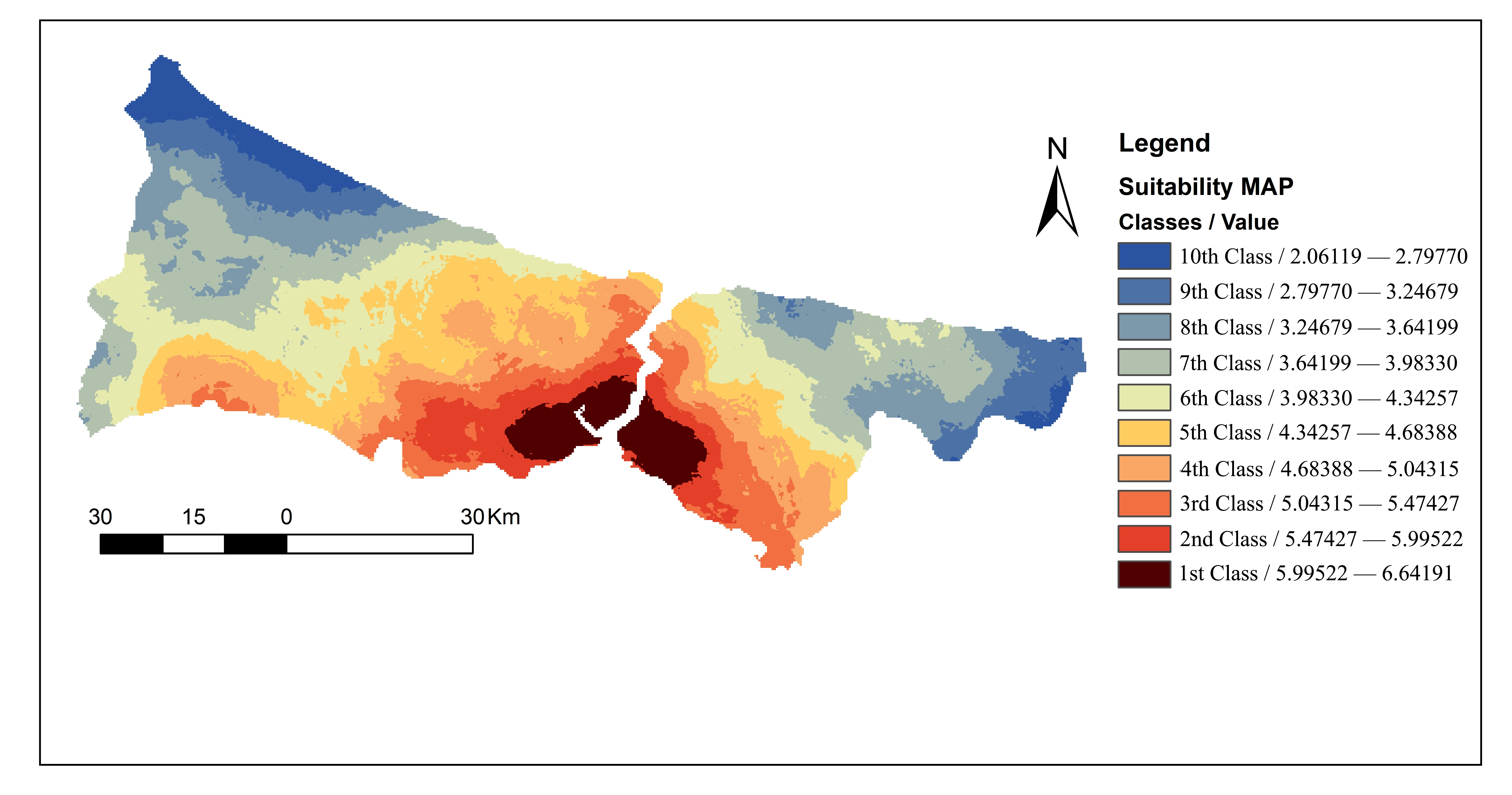
After this process, weighed overlay analysis was carried out with the criterion weights obtained from AHP, and the suitability map for EVCS is presented in Figure 6.
Dark red areas on the map represent the most suitable areas for EVCS sites and are divided into 10 classes in total. As clear from the suitability map, it is observed that the suitable areas for EVCSs are in the south-east on the European side and in the south-west on the Anatolian side.
Moreover, the results show that the ratio of the most suitable and unsuitable areas for EVCS sites in Istanbul to the study area is approximately 5% and 4%, respectively. In all spatial analysis, each pixel represents 900 m2 (30 m × 30 m) area, and natural breaks (Jenks) are used as the classification method.

5.3. Analysis of TOPSIS

Performance evaluation analysis of current EVCSs was carried out via TOPSIS and this stage constitutes the last step of the study. The first step of the TOPSIS process is to determine the cost–benefit aspects of the criteria. Accordingly, while C2.1, C3.2, C3.3, C3.4, C4.3, C6.1, C6.2, and C6.3 of the 18 criteria are cost aspects, and the remaining criteria are benefit aspects. A decision matrix was created using performance values obtained from GIS (excluding C1.1 and C2.1). Performance values of the C1.1 and C2.1 criteria were collected from EVCS service companies.
The decision matrix is normalised, and a weighted standard decision matrix is created using the criterion weights. In the final evaluation process of TOPSIS, the performance ranking of the current EVCSs was performed by considering ideal and nonideal solutions. The evaluation of the stations that have the best and the worst performance values was conducted for the 10 classification regions in the suitability map.
The purpose of this is to provide objectivity by evaluating the suitable area class within itself. There are 144, 75, 35, 20, 13, 5, and 1 current EVCS, in the first, second, third, fourth, fifth, sixth, and seventh classes in the suitability areas, respectively. The ranking results obtained are given in Table 4 and Table 5. The ranking of the 20 best and worst current EVCS locations for the first and second classes suitable areas are given in Table 5.
Performance ranking of each current EVCS was realised by ranking as from large to small the relative closeness ( R C i + ) to the PIS.
The Euclidean distance between the target alternative and the best/worst alternative is calculated at Equations (4) and (5). After the relevant values are calculated, R C i + is calculated using Equation (6).
d i b = j = 1 N ( x i j x j b ) 2
d i w = j = 1 N ( x i j x j w ) 2
R C i + = d i w d i w + d i b
Table 5 shows that the current EVCS position with the highest performance value for the first class is G-Charge23 and the lowest for ZES41. Likewise, for the second class, the best station is Sharz-Voltrun32, and the worst station is G-Charge40. The ranking of the other classes is given in Table 6.
The seventh class is not included in Table 6. This is because there is only one EVCS in the seventh class area; therefore, no ranking was performed. Although Sharz and Voltrun belong to the same company, they serve separately in operation. For this reason, data were provided for two companies together. It was considered as a single company during the evaluation process.

5.4. Sensitivity Analysis

Through a sensitivity analysis, it was possible to measure and test the usability and effects of the criteria on the results and also to define the weights of the criteria as the scenarios changed.
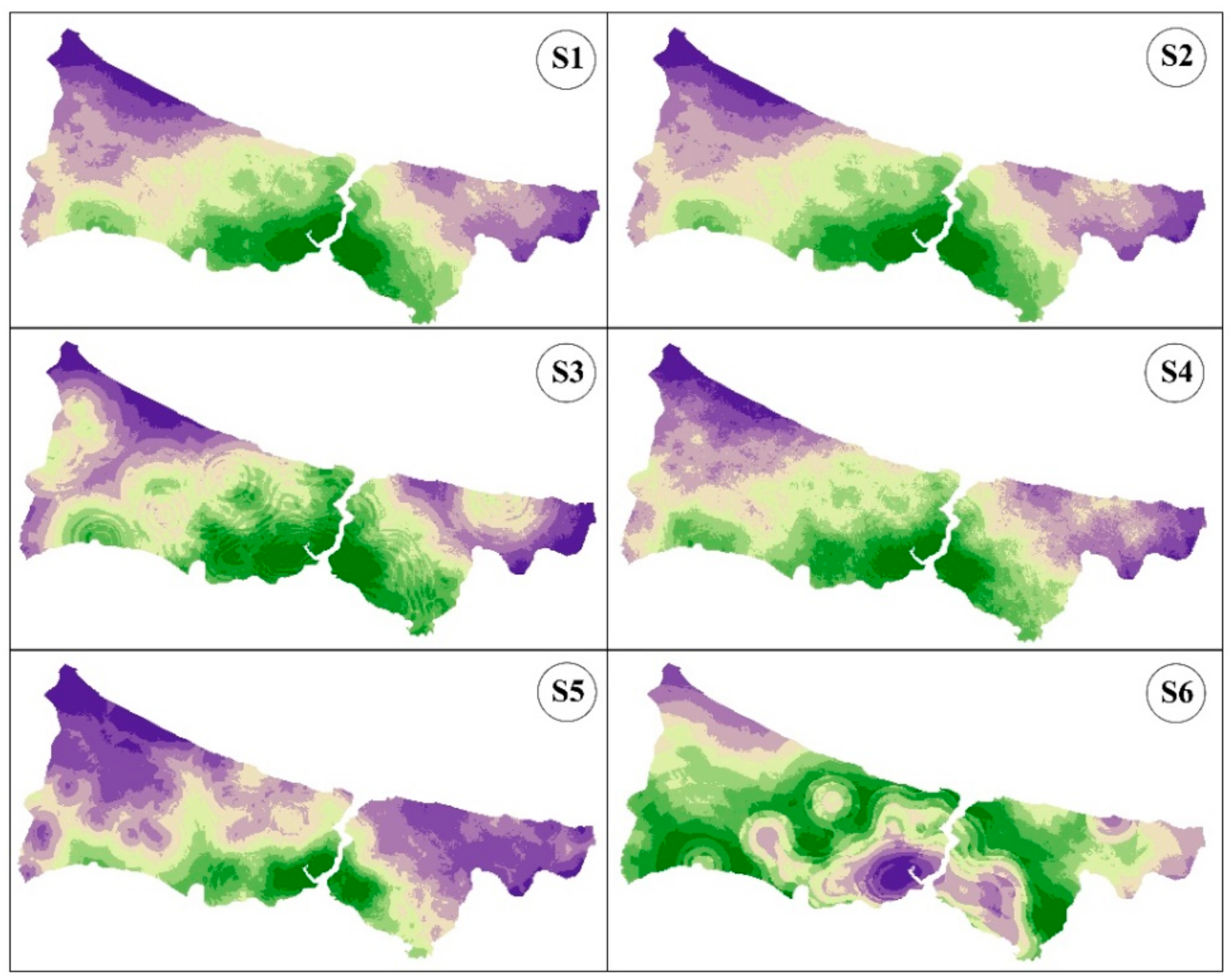
Six scenarios were defined by increasing the weights of the main criteria C1, C2, C3, C4, C5, and C6, respectively, by 100%. The values were increased by 100% to show the change more clearly. Thus, changes can be followed more easily. Suitability maps for these scenarios are presented in Figure 7.
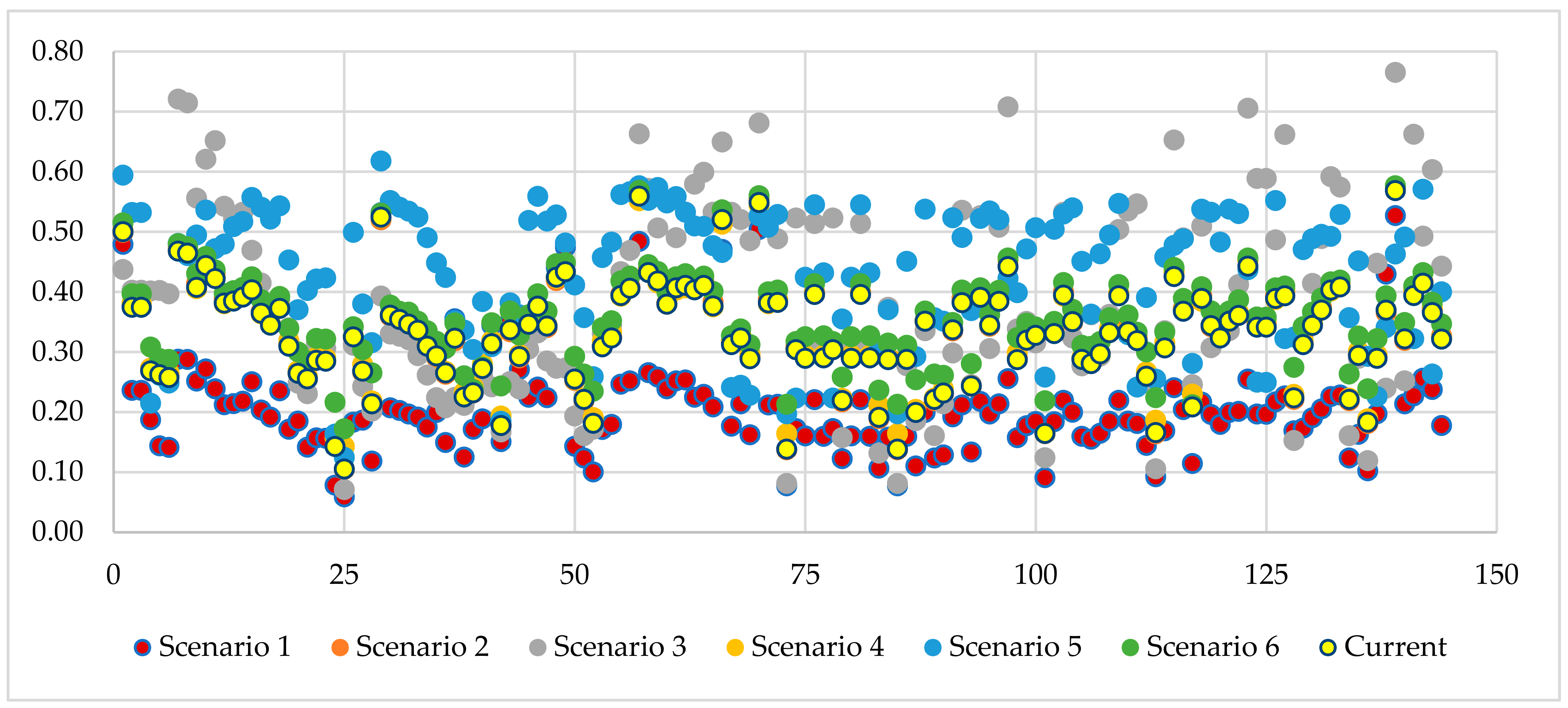
EVCS suitability maps were obtained by reperforming geospatial analysis processes for created each scenario. As it is clear from Figure 7, very serious changes are especially detected in scenarios 3, 5 and 6. When the current criterion weights obtained from AHP are examined, it is among the top three in the order of importance of C3, C6, and C5 main criteria. Differences in scenario maps occur with the change in the weight values of these main criteria. This situation has shown the importance of evaluation criteria weights in site selection problems. Moreover, it reveals that the decision-making team established in determining the criterion weights affects significantly the accuracy of the study. TOPSIS ranking process was remade according to the criteria weights in the created scenarios. The changes in the sensitivity analysis of the TOPSIS ranking are shown in Figure 8. Ranking differences between the current and other scenarios are clearly visible. This condition expresses that the ranking is sensitive according to the selected criteria weights.

6. Discussion

Several studies in the literature carry out general evaluations of site selection.
This research aimed to define a more robust methodology by considering location and service conditions as well as occupational analysis.
For this purpose, a suitability map was created using 16 location criteria. In the process of examining the suitable areas of existing EVCSs, the suitability map was divided into 10 different classes. Each class belonging to the 294 ECVS sites currently present in the examined area was evaluated separately. When the stations are evaluated considering only the geographical location, it is observed that the stations with the best performance values are located in areas where there is an intense interaction in terms of the criteria data considered, i.e., they are the ones with a higher demand for the service.
The present work showed that there are no EVCSs in the suitable areas in classes 8, 9, and 10, while the number of current EVCSs in classes 6 and 7 is insufficient. However, when examining the suitable area of classes 1 and 2, it can be seen that 144 and 75 EVCSs are placed, respectively. The representation of the current EVCS in each class is given in Figure 9.
The main reason for this is that most of the mobility in Istanbul is within the suitable areas defined by classes 1 and 2. However, a minimum number of charging stations must be located in all areas to ensure the continuity of the charging network, to increase the quality of service, and to meet the demand for charging. Thus, the criticality of the absence or reduced availability of charging infrastructure is reduced. With the improvements to be made in the charging infrastructure, the number of electric vehicles will increase and the environmental problems caused by transport will be relatively avoided. The suitability map is a guideline for existing and potential service providers when allocating in areas where the number of EVCS is insufficient.
The study has several limitations to be discussed among which the number of criteria for assessing service quality can be expanded. Indeed, the research can be expanded by making optimal EVCS allocations to classes that are insufficient in terms of current EVCS. If the number of electric vehicles in Turkey does not increase as predicted by governmental and global scenarios, the applicability of the study will be limited. There are of course other important considerations to be made during planning, such as the availability of land/buildings, planning permission, government subsidies and other financial support, and equitable access to charging stations for different sectors of society.

7. Conclusions

This research was conducted evaluating the performance of current EVCSs using a three-step methodology based on the AHP and TOPSIS approach and GIS location. Firstly, the criteria influencing EVCS locations were determined in terms of literature review, experts, and authors’ recommendations. The location and operation criteria are included in the study to increase its accuracy.
While AHP was used in the criteria weighting process, GIS was preferred for the spatial analysis process. As a result of these analyses, the EVCS suitability map for Istanbul was obtained. With the help of this map, it can be seen that the south-eastern parts of the European side and the southwestern parts of the Anatolian side are the most suitable areas. Furthermore, in the suitability map divided into 10 classes, the most suitable and unsuitable areas were found as 275 km2 (1st class) 220 km2 (10th class), respectively. The evaluation analysis of 294 current EVCSs was performed via TOPSIS, considering the suitability map and operational criteria. According to the TOPSIS ranking results of the first six classes, the current EVCSs with the best performance value are G23, SV32, G42, G22, E30, and E27, respectively. The results show that the ratio between the most suitable and unsuitable areas for the location of EVCSs in Istanbul and the study area is about 5% and 4%, respectively. Finally, this paper describes a strategic and scientific framework for evaluating the performance of current EVCSs. This study is a guideline for existing and potential service providers and policymakers. Examining the usage rates of low-scoring EVCSs according to the suitability map and avoiding unnecessary costs will provide a benefit for both the sector companies and policymakers with the help of this paper. The suitable locations of EVCSs planned to be established in the future can be easily analysed via a suitability map. Thus, a major difficulty that may be encountered will be avoided. The suitable location of EVCSs should maximise utilisation and minimise costs.
Future studies can be performed using other MCDM methods such as (VIKOR), (PROMETHEE), and or (GRA). Considering the power system aspect, evaluating the current EVCS is a very good idea for future studies.

Author Contributions

Conceptualisation, Ö.K., K.D.A. and T.C.; methodology, Ö.K., K.D.A., T.C. and M.K.Ç.; software, Ö.K. and K.D.A.; validation, T.C. and A.T.; formal analysis, T.C., A.T. and M.K.Ç.; investigation, Ö.K. and K.D.A.; resources, Ö.K., K.D.A. and T.C.; data curation, Ö.K. and K.D.A.; writing—original draft preparation, Ö.K., K.D.A. and T.C.; writing—review and editing, Ö.K., K.D.A. and T.C.; visualisation, Ö.K., K.D.A. and T.C.; supervision, T.C., A.T. and M.K.Ç.; project administration, T.C.; funding acquisition, T.C. All authors have read and agreed to the published version of the manuscript.

Funding

This research work was also partially funded by the MIUR (Ministry of Education, Universities, and Research [Italy]) through a project entitled WEAKI TRANSIT.

Acknowledgments

This work was supported by the Ministry of Infrastructure and Development as part of the Eastern Poland Development Operational Program in association with the European Regional Development Fund, which financed the research instruments. The authors acknowledge financial support from the MIUR (Ministry of Education, Universities and Research [Italy]) through a project entitled WEAKI TRANSIT: WEAK-demand areas Innovative TRANsport Shared services for Italian Towns (Project code: 20174ARRHT/CUP Code: J74I19000320008), financed with the PRIN 2017 (Research Projects of National Relevance) program. We authorise the MIUR to reproduce and distribute reprints for governmental purposes, notwithstanding any copyright notations thereon. Any opinions, findings, and conclusions, or recommendations expressed in this material are those of the authors and do not necessarily reflect the views of the MIUR.

Conflicts of Interest

The authors declare no conflict of interest.

References

  1. U.S. Energy Information Administration. International Energy Outlook 2016. Available online: https://www.eia.gov/outlooks/ieo/pdf/0484(2016).pdf (accessed on 15 March 2021).
  2. U.S. Energy Information Administration. Monthly Energy Review. April 2021. Available online: https://www.eia.gov/totalenergy/data/monthly/pdf/mer.pdf (accessed on 15 March 2021).
  3. Ritchie, H.; Roser, M. CO2 and Other Greenhouse Gas Emissions. Available online: https://ourworldindata.org/co2-and-other-greenhouse-gas-emissions (accessed on 14 March 2021).
  4. Tiseo, I. Global distribution of CO2 emissions from fossil fuel and cement by sector 2020. Sci. Data 2021, 7, 1–12. [Google Scholar]
  5. U.S. Energy Information Administration. International Energy Outlook 2019. Available online: https://www.eia.gov/outlooks/ieo/pdf/ieo2019.pdf (accessed on 15 March 2021).
  6. McGinn, A.; Isenhour, C. Negotiating the future of the Adaptation Fund: On the politics of defining and defending justice in the post-Paris Agreement period. Clim. Policy 2021, 1–3. [Google Scholar] [CrossRef]
  7. Michaelowa, A.; Michaelowa, K.; Shishlov, I.; Brescia, D. Catalysing private and public action for climate change mitigation: The World Bank’s role in international carbon markets. Clim. Policy 2020, 1–13. [Google Scholar] [CrossRef]
  8. European Commission the European Green Deal. Eur. Comm. 2019, 53, 24. [CrossRef]
  9. Johnston, R.B. Arsenic and the 2030 Agenda for sustainable development. Arsen. Res. Glob. Sustain. As 2016, 12–14. [Google Scholar] [CrossRef]
  10. Madziel, M.; Campisi, T.; Jaworski, A.; Teseoriere, G. The Development of Strategies to Reduce Exhaust Emissions from Passenger Cars in Rzeszow City—Poland A Preliminary Assessment of the Results Produced by the Increase of E-Fleet. Energies 2021, 14, 1046. [Google Scholar]
  11. Teseoriere, G.; Campisi, T. The Benefit of Engage the “Crowd” Encouraging a Bottom-up Approach for Shared Mobility Rating. In Proceedings of the International Conference on Computational Science and Its Applications, Cagliari, Italy, 1–4 July 2020; Springer: Cham, Switzerland, 2020; pp. 836–850. [Google Scholar]
  12. Karjalainen, L.E.; Juhola, S. Urban transportation sustainability assessments: A systematic review of literature. Transp. Rev. 2021, 1–26. [Google Scholar] [CrossRef]
  13. Torrisi, V.; Ignaccolo, M.; Inturri, G.; Tesoriere, G.; Campisi, T. Exploring the factors affecting bike-sharing demand: Evidence from student perceptions, usage patterns and adoption barriers. Transp. Res. Procedia 2021, 52, 573–580. [Google Scholar] [CrossRef]
  14. Campisi, T.; Basbas, S.; Skoufas, A.; Akgün, N.; Ticali, D.; Tesoriere, G. The Impact of COVID-19 Pandemic on the Resilience of Sustainable Mobility in Sicily. Sustainability 2020, 12, 8829. [Google Scholar] [CrossRef]
  15. Moraci, F.; Errigo, M.F.; Fazia, C.; Campisi, T.; Castelli, F. Cities under pressure: Strategies and tools to face climate change and pandemic. Sustainability 2020, 12, 7743. [Google Scholar] [CrossRef]
  16. Saygın, D.; Bülent Tör, O.; Teimourzadeh, S.; Koç, M.; Hildermeier, J.; Kolokathis, C. Transport Sector Transformation: Integrating Electric Vehicles into Turkey’s Distribution Grids. SHURA Istanbul. 2019. Available online: https://www.shura.org.tr/wp-content/uploads/2019/12/Transport-sector-transformation.Integrating-electric-vehicles-into-Turkey%E2%80%99s-distribution-grids.pdf (accessed on 18 March 2021).
  17. Hong, I.; Kuby, M.; Murray, A.T. A range-restricted recharging station coverage model for drone delivery service planning. Transp. Res. Part. C Emerg. Technol. 2018, 90, 198–212. [Google Scholar] [CrossRef]
  18. Huang, H.; Savkin, A.V. A Method of Optimized Deployment of Charging Stations for Drone Delivery. IEEE Trans. Transp. Electrif. 2020, 6, 510–518. [Google Scholar] [CrossRef]
  19. Erbaş, M.; Kabak, M.; Özceylan, E.; Çetinkaya, C. Optimal siting of electric vehicle charging stations: A GIS-based fuzzy Multi-Criteria Decision Analysis. Energy 2018, 163, 1017–1031. [Google Scholar] [CrossRef]
  20. Istanbul Metropolitan Municipality Istanbul Transport Annual Report. Available online: https://tuhim.ibb.gov.tr/en/statistical-information/ (accessed on 18 October 2020).
  21. Feng, J.; Xu, S.X.; Li, M. A novel multi-criteria decision-making method for selecting the site of an electric-vehicle charging station from a sustainable perspective. Sustain. Cities Soc. 2021, 65, 102623. [Google Scholar] [CrossRef]
  22. Wu, Y.; Xie, C.; Xu, C.; Li, F. A decision framework for electric vehicle charging station site selection for residential communities under an intuitionistic fuzzy environment: A case of Beijing. Energies 2017, 10, 1270. [Google Scholar] [CrossRef]
  23. Gan, X.; Zhang, H.; Hang, G.; Qin, Z.; Jin, H. Fast-Charging Station Deployment Considering Elastic Demand. IEEE Trans. Transp. Electrif. 2020, 6, 158–169. [Google Scholar] [CrossRef]
  24. Kabak, M.; Erbaş, M.; Çetinkaya, C.; Özceylan, E. A GIS-based MCDM approach for the evaluation of bike-share stations. J. Clean. Prod. 2018, 201, 49–60. [Google Scholar] [CrossRef]
  25. Lin, M.; Huang, C.; Xu, Z. MULTIMOORA based MCDM model for site selection of car sharing station under picture fuzzy environment. Sustain. Cities Soc. 2020, 53, 101873. [Google Scholar] [CrossRef]
  26. Wu, Y.; Yang, M.; Zhang, H.; Chen, K.; Wang, Y. Optimal site selection of electric vehicle charging stations based on a cloud model and the PROMETHEE method. Energies 2016, 9, 157. [Google Scholar] [CrossRef] [Green Version]
  27. Xu, J.; Zhong, L.; Yao, L.; Wu, Z. An interval type-2 fuzzy analysis towards electric vehicle charging station allocation from a sustainable perspective. Sustain. Cities Soc. 2018, 40, 335–351. [Google Scholar] [CrossRef]
  28. Jordán, J.; Palanca, J.; del Val, E.; Julian, V.; Botti, V. Using Genetic Algorithms to Optimize the Location of Electric Vehicle Charging Stations. In Proceedings of the 13th International Conference on Soft Computing Models in Industrial and Environmental Applications, Seville, Spain, 13–15 May 2019; Springer International Publishing: Cham, Switzerland, 2019. [Google Scholar]
  29. Zhao, H.; Li, N. Optimal siting of charging stations for electric vehicles based on fuzzy Delphi and hybrid multi-criteria decision making approaches from an extended sustainability perspective. Energies 2016, 9, 270. [Google Scholar] [CrossRef] [Green Version]
  30. Zhang, S.; Wang, H.; Zhang, Y.; Li, Y.-Z. A novel two-stage location model of charging station considering dynamic distribution of electric taxis. Sustain. Cities Soc. 2019, 51, 101752. [Google Scholar] [CrossRef]
  31. Wang, W.; Zhang, Q.; Peng, Z.; Shao, Z.; Li, X. An empirical evaluation of different usage pattern between car-sharing battery electric vehicles and private ones. Transp. Res. Part. A Policy Pract. 2020, 135, 115–129. [Google Scholar] [CrossRef]
  32. Ju, Y.; Ju, D.; Santibanez Gonzalez, E.D.R.; Giannakis, M.; Wang, A. Study of site selection of electric vehicle charging station based on extended GRP method under picture fuzzy environment. Comput. Ind. Eng. 2019, 135, 1271–1285. [Google Scholar] [CrossRef]
  33. Ko, J.; Kim, D.; Nam, D.; Lee, T. Determining locations of charging stations for electric taxis using taxi operation data. Transp. Plan. Technol. 2017, 40, 420–433. [Google Scholar] [CrossRef]
  34. Guo, S.; Zhao, H. Optimal site selection of electric vehicle charging station by using fuzzy TOPSIS based on sustainability perspective. Appl. Energy 2015, 158, 390–402. [Google Scholar] [CrossRef]
  35. Hosseini, S.; Sarder, M.D. Development of a Bayesian network model for optimal site selection of electric vehicle charging station. Int. J. Electr. Power Energy Syst. 2019, 105, 110–112. [Google Scholar] [CrossRef]
  36. Shahraki, N.; Cai, H.; Turkay, M.; Xu, M. Optimal locations of electric public charging stations using real world vehicle travel patterns. Transp. Res. Part. D Transp. Environ. 2015, 41, 165–176. [Google Scholar] [CrossRef] [Green Version]
  37. Deveci, M.; Canıtez, F.; Gökaşar, I. WASPAS and TOPSIS based interval type-2 fuzzy MCDM method for a selection of a car sharing station. Sustain. Cities Soc. 2018, 41, 777–791. [Google Scholar] [CrossRef]
  38. Çalış Boyacı, A.; Şişman, A.; Sarıcaoğlu, K. Site selection for waste vegetable oil and waste battery collection boxes: A GIS-based hybrid hesitant fuzzy decision-making approach. Environ. Sci. Pollut. Res. 2021. [Google Scholar] [CrossRef]
  39. Haddad, B.; Díaz-Cuevas, P.; Ferreira, P.; Djebli, A.; Pérez, J.P. Mapping concentrated solar power site suitability in Algeria. Renew. Energy 2021, 168, 838–853. [Google Scholar] [CrossRef]
  40. Koop, A. Ranked: The Most Populous Cities in the World. Available online: https://www.visualcapitalist.com/most-populous-cities-in-the-world/ (accessed on 12 March 2021).
  41. Turkish Statistical Institute Number of Vehicles by Provinces. Available online: http://www.tuik.gov.tr/PreIstatistikTablo.do?istab_id=1581 (accessed on 14 March 2021).
  42. Istanbul Metropolitan Municipality Istanbul Climate Change Action Plan. 2018. Available online: https://www.iklim.istanbul/wp-content/uploads/%C3%96zetRapor%C4%B0ngilizce.pdf (accessed on 16 March 2021).
  43. Ağbulut, Ü.; Bakır, H. The Investigation on Economic and Ecological Impacts of Tendency to Electric Vehicles Instead of Internal Combustion Engines. Düzce Univ. J. Sci. Technol. 2019, 7, 25–36. [Google Scholar] [CrossRef] [Green Version]
  44. Compare the Market Cost of Charging an Electric Car Globally. Available online: https://www.comparethemarket.com/car-insurance/content/cost-of-charging-an-electric-car-globally/ (accessed on 16 March 2021).
  45. Harighi, T.; Padmanaban, S.; Bayindir, R.; Hossain, E.; Holm-Nielsen, J.B. Electric vehicle charge stations location analysis and determination—Ankara (Turkey) case study. Energies 2019, 12, 3472. [Google Scholar] [CrossRef] [Green Version]
  46. Statista Number of Electric Vehicle Charging Stations in Turkey by Type 2012–2019. Available online: https://www.statista.com/statistics/935960/number-of-electric-vehicle-charging-stations-turkey (accessed on 16 March 2021).
  47. Yalçın, D.; Arıkan, F. Electric Vehicle Regulation and Law in Turkey. Progr. Plann. 2000, 54, 199–278. [Google Scholar]
  48. Zhang, Q.; Li, H.; Zhu, L.; Campana, P.E.; Lu, H.; Wallin, F.; Sun, Q. Factors influencing the economics of public charging infrastructures for EV—A review. Renew. Sustain. Energy Rev. 2018, 94, 500–509. [Google Scholar] [CrossRef]
  49. Hardman, S.; Jenn, A.; Tal, G.; Axsen, J.; Beard, G.; Daina, N.; Figenbaum, E.; Jakobsson, N.; Jochem, P.; Kinnear, N. A review of consumer preferences of and interactions with electric vehicle charging infrastructure. Transp. Res. Part. D Transp. Environ. 2018, 62, 508–523. [Google Scholar] [CrossRef] [Green Version]
  50. Lin, X.; Sun, J.; Ai, S.; Xiong, X.; Wan, Y.; Yang, D. Distribution network planning integrating charging stations of electric vehicle with V2G. Int. J. Electr. Power Energy Syst. 2014, 63, 507–512. [Google Scholar] [CrossRef]
  51. Filote, C.; Felseghi, R.A.; Raboaca, M.S.; Aşchilean, I. Environmental impact assessment of green energy systems for power supply of electric vehicle charging station. Int. J. Energy Res. 2020, 44, 10471–10494. [Google Scholar] [CrossRef]
  52. Awasthi, A.; Venkitusamy, K.; Padmanaban, S.; Selvamuthukumaran, R.; Blaabjerg, F.; Singh, A.K. Optimal planning of electric vehicle charging station at the distribution system using hybrid optimization algorithm. Energy 2017, 133, 70–78. [Google Scholar] [CrossRef]
  53. Chen, T.D.; Kockelman, K.M.; Khan, M. Locating Electric Vehicle Charging Stations: Parking-Based Assignment Method for Seattle, Washington. Transp. Res. Rec. J. Transp. Res. Board 2013, 2385, 28–36. [Google Scholar] [CrossRef]
  54. Shi, R.; Zhang, J.; Su, H.; Liang, Z.; Lee, K.Y. An Economic Penalty Scheme for Optimal Parking Lot Utilization with EV Charging Requirements. Energies 2020, 13, 6155. [Google Scholar] [CrossRef]
  55. Kwag, S.I.; Hur, U.; Ko, Y.D. Sustainable electric personal mobility: The design of a wireless charging infrastructure for urban tourism. Sustainability 2021, 13, 1270. [Google Scholar] [CrossRef]
  56. Ko, Y.D.; Song, B.D. Sustainable service design and revenue management for electric tour bus systems: Seoul city tour bus service and the eco-mileage program. J. Sustain. Tour. 2019, 27, 308–326. [Google Scholar] [CrossRef]
  57. Tu, W.; Li, Q.; Fang, Z.; Shaw, S.L.; Zhou, B.; Chang, X. Optimizing the locations of electric taxi charging stations: A spatial–temporal demand coverage approach. Transp. Res. Part. C Emerg. Technol. 2016, 65, 172–189. [Google Scholar] [CrossRef] [Green Version]
  58. Qu, Z.; Wang, X.; Song, X.; Pan, Z.; Li, H. Location Optimization for Urban Taxi Stands Based on Taxi GPS Trajectory Big Data. IEEE Access 2019, 7, 62273–62283. [Google Scholar] [CrossRef]
  59. Guler, D.; Yomralioglu, T. Suitable location selection for the electric vehicle fast charging station with AHP and fuzzy AHP methods using GIS. Ann. GIS 2020, 26, 169–189. [Google Scholar] [CrossRef] [Green Version]
  60. Raposo, J.; Rodrigues, A.; Silva, C.; Dentinho, T. A multi-criteria decision aid methodology to design electric vehicles public charging networks. AIP Adv. 2015, 5. [Google Scholar] [CrossRef] [Green Version]
  61. He, Y.; Zhou, X.; Liu, Z.; Ran, M. Layout optimization design of electric vehicle charging station based on urban parking lot. Lect. Notes Electr. Eng. 2018, 419, 399–407. [Google Scholar] [CrossRef]
  62. Saaty, T.L. A scaling method for priorities in hierarchical structures. J. Math. Psychol. 1977, 15, 234–281. [Google Scholar] [CrossRef]
  63. Saaty, T.L. The Analytic Hierarchy Process. In Içinde Encyclopedia of Biostatistics; McGraw-Hill: New York, NY, USA, 1980. [Google Scholar]
  64. Ge, Y.; Xiao, M.; Wang, X.; Zhang, L.; Wang, W.; Hou, X. AHP method research of decision-making information system in integrated test technology based on granular computing. In Proceedings of the 2015 IEEE International Conference on Signal Processing, Communications and Computing (ICSPCC), Ningbo, China, 19–22 September 2015. [Google Scholar]
  65. Moeinaddini, M.; Khorasani, N.; Danehkar, A.; Darvishsefat, A.A.; Zienalyan, M. Siting MSW landfill using weighted linear combination and analytical hierarchy process (AHP) methodology in GIS environment (case study: Karaj). Waste Manag. 2010, 30, 912–920. [Google Scholar] [CrossRef]
  66. Klein, L.L.; Tonetto, M.S.; Avila, L.V.; Moreira, R. Management of lean waste in a public higher education institution. J. Clean. Prod. 2021, 286, 125386. [Google Scholar] [CrossRef]
  67. Díaz-López, C.; Carpio, M.; Martín-Morales, M.; Zamorano, M. Defining strategies to adopt Level(s) for bringing buildings into the circular economy. A case study of Spain. J. Clean. Prod. 2021, 287. [Google Scholar] [CrossRef]
  68. Ramavandi, B.; Darabi, A.H.; Omidvar, M. Risk assessment of hot and humid environments through an integrated fuzzy AHP-VIKOR method. Stoch. Environ. Res. Risk Assess. 2021, 1. [Google Scholar] [CrossRef]
  69. Hartanto, B.W.; Mayasari, D.S. Environmentally friendly non-medical mask: An attempt to reduce the environmental impact from used masks during COVID 19 pandemic. Sci. Total Environ. 2021, 760, 144143. [Google Scholar] [CrossRef] [PubMed]
  70. Abdallah, M.; Hamdan, S.; Shabib, A. A multi-objective optimization model for strategic waste management master plans. J. Clean. Prod. 2021, 284, 124714. [Google Scholar] [CrossRef]
  71. Abdel-Basset, M.; Gamal, A.; Chakrabortty, R.K.; Ryan, M.J. Evaluation approach for sustainable renewable energy systems under uncertain environment: A case study. Renew. Energy 2021, 168, 1073–1095. [Google Scholar] [CrossRef]
  72. Koohathongsumrit, N.; Meethom, W. Route selection in multimodal transportation networks: A hybrid multiple criteria decision-making approach. J. Ind. Prod. Eng. 2021, 38, 171–185. [Google Scholar] [CrossRef]
  73. Kutlu Gündoğdu, F.; Duleba, S.; Moslem, S.; Aydın, S. Evaluating public transport service quality using picture fuzzy analytic hierarchy process and linear assignment model. Appl. Soft Comput. 2021, 100, 106920. [Google Scholar] [CrossRef]
  74. Şahin, T.; Ocak, S.; Top, M. Analytic hierarchy process for hospital site selection. Health Policy Technol. 2019, 8, 42–50. [Google Scholar] [CrossRef]
  75. Martindale, J. Mapping and Geographic Information Systems (GIS). Available online: https://researchguides.library.wisc.edu/prf.php?account_id=55066 (accessed on 18 September 2020).
  76. Marzouk, M.; Attia, K.; Azab, S. Assessment of Coastal Vulnerability to Climate Change Impacts using GIS and Remote Sensing: A Case Study of Al-Alamein New City. J. Clean. Prod. 2021, 290, 125723. [Google Scholar] [CrossRef]
  77. Pászto, V.; Burian, J.; Macků, K. Changing mobility lifestyle: A case study on the impact of COVID-19 using personal google locations data. Int. J. E Plan. Res. 2021, 10, 66–79. [Google Scholar] [CrossRef]
  78. Ramos-Escudero, A.; García-Cascales, M.S.; Cuevas, J.M.; Sanner, B.; Urchueguía, J.F. Spatial analysis of indicators affecting the exploitation of shallow geothermal energy at European scale. Renew. Energy 2021, 167, 266–281. [Google Scholar] [CrossRef]
  79. Tissen, C.; Menberg, K.; Benz, S.A.; Bayer, P.; Steiner, C.; Götzl, G.; Blum, P. Identifying key locations for shallow geothermal use in Vienna. Renew. Energy 2021, 167, 1–19. [Google Scholar] [CrossRef]
  80. Luan, C.; Liu, R.; Peng, S. Land-use suitability assessment for urban development using a GIS-based soft computing approach: A case study of Ili Valley, China. Ecol. Indic. 2021, 123, 107333. [Google Scholar] [CrossRef]
  81. Wubalem, A. Landslide Susceptibility Mapping using Statistical Methods in Uatzau Catchment Area, Northwestern Ethiopia. Geoenviron. Disasters 2020, 8, 1–21. [Google Scholar] [CrossRef]
  82. Li, J.; Pei, X.; Wang, X.; Yao, D.; Zhang, Y.; Yue, Y. Transportation mode identification with GPS trajectory data and GIS information. Tsinghua Sci. Technol. 2021, 26, 403–416. [Google Scholar] [CrossRef]
  83. Wang, T.C.; Chang, T.H. Application of TOPSIS in evaluating initial training aircraft under a fuzzy environment. Expert Syst. Appl. 2007, 33, 870–880. [Google Scholar] [CrossRef]
  84. Karaşan, A.; Kaya, İ.; Erdoğan, M. Location selection of electric vehicles charging stations by using a fuzzy MCDM method: A case study in Turkey. Neural Comput. Appl. 2018, 1–22. [Google Scholar] [CrossRef]
  85. Çetinkaya, C.; Özceylan, E.; Erbaş, M.; Kabak, M. GIS-based fuzzy MCDA approach for siting refugee camp: A case study for southeastern Turkey. Int. J. Disaster Risk Reduct. 2016, 18, 218–231. [Google Scholar] [CrossRef]
  86. Nyimbili, P.H.; Erden, T.; Karaman, H. Integration of GIS, AHP and TOPSIS for earthquake hazard analysis. Nat. Hazards 2018, 92, 1523–1546. [Google Scholar] [CrossRef]
  87. Muhsen, D.H.; Haider, H.T.; Al-Nidawi, Y.M.; Khatib, T. Domestic load management based on integration of MODE and AHP-TOPSIS decision making methods. Sustain. Cities Soc. 2019, 50, 101651. [Google Scholar] [CrossRef]
  88. Behzadian, M.; Khanmohammadi Otaghsara, S.; Yazdani, M.; Ignatius, J. A state-of the-art survey of TOPSIS applications. Expert Syst. Appl. 2012, 39, 13051–13069. [Google Scholar] [CrossRef]
  89. Chen, P. Effects of normalization on the entropy-based TOPSIS method. Expert Syst. Appl. 2019, 136, 33–41. [Google Scholar] [CrossRef]
  90. Awasthi, A.; Omrani, H.; Gerber, P. Investigating ideal-solution based multicriteria decision making techniques for sustainability evaluation of urban mobility projects. Transp. Res. Part. A Policy Pract. 2018, 116, 247–259. [Google Scholar] [CrossRef]
  91. Alonso, J.A.; Lamata, M.T. Consistency in the Analytic Hierarchy Process: A New Approach. Int. J. Uncertain. Fuzziness Knowl. Based Syst. 2006, 14, 445–459. [Google Scholar] [CrossRef] [Green Version]
  92. Withanage, G.P.; Gunawardana, M.; Viswakula, S.D.; Samaraweera, K.; Gunawardena, N.S.; Hapugoda, M.D. Multivariate spatio-temporal approach to identify vulnerable localities in dengue risk areas using Geographic Information System (GIS). Sci. Rep. 2021, 11, 4080. [Google Scholar] [CrossRef]
  93. Xie, Z.; Yan, J. Kernel Density Estimation of traffic accidents in a network space. Comput. Environ. Urban Syst. 2008, 32, 396–406. [Google Scholar] [CrossRef] [Green Version]
  94. Okabe, A.; Satoh, T.; Sugihara, K. A kernel density estimation method for networks, its computational method and a GIS-based tool. Int. J. Geogr. Inf. Sci. 2009, 23, 7–32. [Google Scholar] [CrossRef]
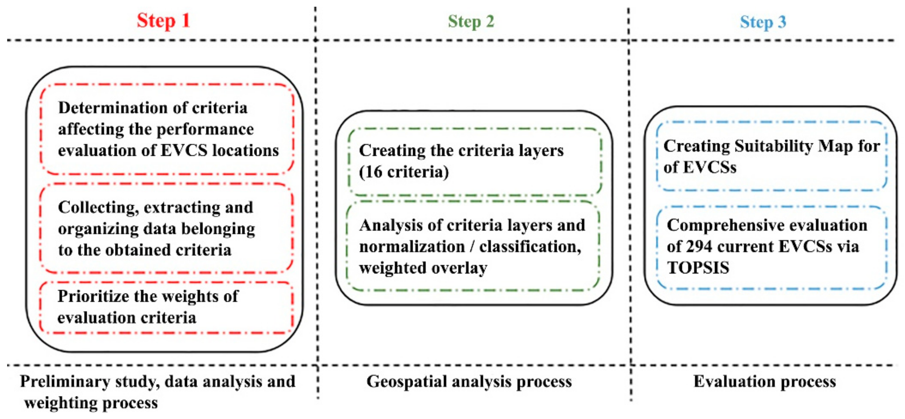
Figure 1. Steps of analysis and the related short descriptions.
Energies 14 02756 g001
Figure 2. Examples of EVCSs in Turkey.
Energies 14 02756 g002
Figure 3. Study area.
Energies 14 02756 g003
Figure 4. Number of electric vehicle charging stations in Turkey, by type [46].
Energies 14 02756 g004
Figure 5. Normalisation maps of 16 evaluation criteria.
Energies 14 02756 g005
Figure 6. Suitability map for EVCSs.
Energies 14 02756 g006
Figure 7. Suitability maps for changed criterion weights.
Energies 14 02756 g007
Figure 8. Ranking changes of current EVCSs due to changed criteria weights.
Energies 14 02756 g008
Figure 9. Distribution of EVCS by classes.
Energies 14 02756 g009
Table 1. Overview of site selection studies on EVCSs.
Study AreaN Sub-CriteriaApplied MethodsEVCS LocationRef.
Beijing15ANP-PROMETHEEGeneral locations analysis[26]
Tianfu14Entropy-ELECTREThe most suitable locations considering 6/30 alternatives[27]
Valencia5Genetic Algorithm-Multi Agent SystemsEstimation of the best configurations[28]
Tianjin13Fuzzy Grey Relation Analysis-Fuzzy VIKOR-EntropyEmpirical study of five alternatives locations[29]
ChengduaDynamic Clustering-Barycentric MethodManaging the location of the e-taxi charging station[30]
EmpiricallybRobust Optimisation Algorithm-Queuing TheoryOptimisation of location reducing construction costs and the number of EVCSs.[31]
Beijing14Fuzzy AHP-Grey Relational Projection (GRP)-Picture Fuzzy Weighted Interaction Geometric (PFWIG)Optimisation and selection of suitable location.[32]
SeoulcMaximum Set Covering ModelOptimisation of location using data for one week.[33]
Beijing11Fuzzy TOPSISOptimisation of location considering four alternative EVCSs.[34]
Tehran10Bayesian NetworkOptimisation of location considering four alternative EVCSs.[35]
BeijingdMathematical ModelsComparative analysis considering the actual 40 public charging stations.[36]
İstanbul9WASPAS-TOPSISA simple approach model is proposed to evaluate four car-sharing stations.[37]
a Global position system, b uncertainty of charging demand, c taxi travel patterns data, d vehicle trajectory data of taxis.
Table 2. Comparison of costs related to charging station [44].
Cost per KWh
(EUR)
Cost per Charge
(EUR)
Cost per 10 Miles
(EUR)
Cost per 100 Miles
(EUR)
Turkey 0.0757.480.181.85
US0.13713.690.343.38
UK0.14914.870.373.67
Italy0.14114.110.343.49
Australia0.17117.140.424.23
Japan0.19919.910.504.91
Table 3. The background of each criterion.
Main CriteriaSub-CriteriaDescriptionsReferences
Properties of StationC1.1Service CapacityStatus and number of available sockets at stations. This situation affects the service capacity of the station.
C1.2Charge PowerCharging time, speed at stations, and fast charging status. This affects the service performance of the stations, as electric vehicles will be produced with the fast-charging option.
Energy/PowerC2.1Electrical SubstationDistance and proximity to substations. Proximity to the electrical substation is effective in meeting the energy demand of the stations.[19,26,29,50]
C2.2Source of Renewable EnergyInfluence of operating costs. Siting the stations in regions where the availability of renewable energy resources is important in terms of operating costs.[30,33,51]
Environmental/UrbanityC3.1Population SizeE-vehicle ownership and e-mobility demand. The population size is linked to electric vehicle ownership.[26,29,32,34,52]
C3.2Social and Public AreasPotential e-mobility demand and habits. Considering that, people often spend time in these areas; the potential demand for charging is high in related areas.[30,50]
C3.3Tourism RegionAttractiveness of the area. It affects EVCS locations due to the charging time of electric vehicles and the travel situation to these areas.[53,54,55,56]
C3.4Service CentreTimeliness of the maintenance service. To provide uninterrupted service at the stations, rapid intervention is required in case of malfunction or maintenance.
C3.5Environmental PollutionEnvironmental damage caused by energy consumption. Electric vehicles should be disseminated and encouraged in regions with high emission values.[35]
PhysiographicC4.1WoodlandProtection of green area. To protect green areas, regions far from these regions should be preferred where EVCS is located.[19,27,32,34]
C4.2Aquatic Resources Water resources protection. To protect water resources, regions far from these regions should be preferred where EVCS is located.[19,27,35]
C4.3Slope of LandPlano-altimetrico development of the infrastructure Considering the operating and construction costs, areas where the slope percentage is low should be preferred for EVCS sitting.[19]
FinanciallyC5.1Income RateThe income level of people influences the ownership. Electric vehicle ownership is generally concentrated in high-income regions.
C5.2Motor VehiclesIt is suitable for the e-mobility trend. It is predicted that the rate of electrification will be high in regions where the number of conventional motor vehicles is high.[30]
C5.3E-VehiclesIt influences transport demand/supply. The need for charging is high in areas where electric vehicles are intense.[27,29]
TransportationC6.1Road NetworksOperation efficiency of EVCSs close to road networks will be high. [19,30,33,57,58]
C6.2Intersection AreaOperational efficiency and accessibility.[17,55]
C6.3Parking SpacesParking lot and garages in the service area. When the charging time is considered in the suitable siting of EVCSs, the parking spaces used intensively by the vehicles affect the EVCS locations.[56,57,59,60,61]
Table 4. The weights of evaluation criteria.
C1C2C3C4C5C6
Properties of StationsEnergy/PowerEnvironmental/UrbanityPhysiographicFinanciallyTransportation
C1.10.0829C2.10.0219C3.10.0726C4.10.0313C5.10.0357C6.10.0507
C1.20.0792C2.20.0215C3.20.0765C4.20.0288C5.20.0469C6.20.0409
C3.30.0168C4.30.0193C5.30.1215C6.30.1280
C3.40.0145
C3.50.1108
Total0.1621 0.0435 0.2912 0.0794 0.2041 0.2196
Table 5. Ranking of 20 best and worst current EVCSs in first and second classes.
The top 20 in first classEVCSG23E45SV0Z48E55Z0Z18Z19Z21SV105
R C i + 0.56870.55930.54860.52460.52050.50020.46800.46450.44370.4427
EVCSSV51E18E46S90E17Z22E47G35E51E53
R C i + 0.44190.43350.43220.42560.42420.42230.41820.41430.41090.4109
The top 20 in second classEVCSSV32G16G43E49Sv78E39Z31SV58SV92G27
R C i + 0.50310.46930.45920.43670.43300.43200.41810.40650.40160.4012
EVCSZ46Z30Z15Z12SV82SV47Z47E66Z35SV38
R C i + 0.39070.38600.38410.36800.36740.36720.35320.33990.33350.3328
The bottom 20 in first classEVCSSV40E2G2SV37G10E20SV15Z45SV93SV28
R C i + 0.23160.22510.22380.22110.22110.22110.21920.21390.20880.1996
EVCSSV20G14E40E10SV86SV62Z39SV3SV23Z41
R C i + 0.19140.18320.18160.17770.16580.16460.14280.13850.13850.1054
The bottom 20 in second classEVCSE33G15Z60Z42E59E60G12E63E64E22
R C i + 0.25220.24890.24350.23730.23230.22290.22130.22060.22060.2172
EVCSZ13SV52Z63SV29G13E23G25SV94Z61G40
R C i + 0.21220.21090.20920.20310.20260.20190.19930.18600.16640.1378
Z: ZES, E: Eşarj, SV: Sharz-Voltrun, G: G-Charge.
Table 6. Ranking of best and worst current EVCSs in, third, fourth, fifth, and sixth classes.
third classRank12345678910111213
EVCSG42G7S113Z64Z69Z62Z59Z11E6Z65SV79SV108E25
R C i + 0.51610.43670.43200.41810.39070.38600.38410.36800.35320.33350.33260.33110.3208
Rank14151617181920212223242526
EVCSG32G31SV99SV112Z10Z67E28Z66SV84E32SV57E7Z68
R C i + 0.31450.31430.31350.31000.30760.29580.26890.26490.26020.25600.25220.24350.2373
Rank272829303132333435
EVCSG20G29G33G41SV24Z58E24SV55E8
R C i + 0.23230.22290.22060.22060.21720.21220.20920.20190.1664
fourth classRank12345678910111213
EVCSG22SV22G26E29E5G21SV71G1SV61SV83SV87G28Z8
R C i + 0.51130.48210.33120.31320.28040.26620.24790.22900.22890.22780.21130.20860.1983
Rank14151617181920
EVCSSV95G8Z5SV39E26E27G0
R C i + 0.19430.19180.18680.17840.15950.15150.1443
fifth classRank12345678910111213
EVCSE30E31G3SV100SV107SV26SV27SV4SV5SV81Z6Z7Z9
R C i + 0.85910.86490.09110.18530.09100.10260.10400.10260.10400.09390.07490.11680.1025
sixth classRank12345
EVCSE27Z8Z5E5E26
R C i + 0.80630.27910.25520.21550.1339
Z: ZES, E: Eşarj, SV: Sharz-Voltrun, G: G-Charge.
Publisher’s Note: MDPI stays neutral with regard to jurisdictional claims in published maps and institutional affiliations.