1. Introduction
Hard coal mining in Europe had a tremendous influence on its economic development in the 20th century. Yet, the new European Climate Law is focused on withdrawing from coal-based power generation [
1]. The process of closing a hard coal mine can be carried out in radically different ways, from a complex risk assessment and control during and after a mine closure, to simply backfilling shafts without forecasting the long-term consequences of such decisions for the environment and the community. Hazards occurring in the course of mine closure processes have been discussed in the professional literature in many countries where this problem occurs, such as: South Africa (strategies for water mining) [
2], Australia (comprehensive closure plans) [
3], in Canada (mine reclamation guidelines) [
4], Finland (procedures for employing and planning mine closures) [
5], and France (hazards were mapped) [
6].
Unfortunately, in many countries where coal mines were closed long ago, the negative consequences are still observed, such as subsidence, e.g., Krater von Wattenscheid in Bochum (Germany), and a large post-mining sinkhole that formed on the surface in the area of St. Goar-Werlau (Germany) [
7]. Other negative consequences associated with mine closures are methane concentrations and emissions. Cases when dangerous concentrations of gases occurred in the ground floor areas and basements of buildings were recorded e.g., in the Czech Republic [
8] and France [
6]. Methane concentrations may also occur in the areas where mine closure works are conducted e.g., during backfilling shafts, as happened in Poland during the closure of the Morcinek mine [
9]. A methane explosion in the ventilation shaft injured nine people working in the mine shaft building. Mining activities at the final stage of a closure ought to be based on the experiences and good practice of the countries that have already been through the process. Moreover, due to numerous negative consequences of the mining process itself, many phenomena occurring in the affected areas are automatically linked to coal mining, regardless of its actual effect on their occurrence [
10].
Methane emissions entail the following two risks: first, as methane is a greenhouse gas, it has a particularly negative effect on the environment. Second, it may reach dangerous concentrations in the ground floor areas and basements of buildings as well as in areas where mine closure works are conducted, resulting in intoxication, asphyxia or explosions, occurring possibly with methane concentration between 5% and 15%.
Methane plays an important role when considering the efforts allowing us to understand and address the global climate change. Given the above, estimating the possible methane emissions in the course of mine closure processes will prove useful for performing inventories of greenhouse gas emissions from closed sites, thus enabling the quantification of the anthropogenic sources. This type of methane is called abandoned mine methane (AMM) [
11]. Moreover, these forecasts also serve to address feasibility studies on methane recovery opportunities at the same time preventing the methane escaping to the atmosphere, something that will inevitably occur as methane is less dense than air, and geological structures are never perfectly airtight traps [
12,
13]. Considering a 20-year period, the effect of methane on global warming can be estimated as 84 times greater than that of CO
2.
The risk is related to the possibility of gas migration to the surface. Such migration is possible in areas where methane, as a result of natural depression, can migrate to the near-surface layers. Most often they are areas of shallow mining operations, closed shafts, as well as faults or seam outcrops. They are presented in
Figure 1.
The research presented in this article develops knowledge in the field of gas risk, especially in mines currently closed, for which the results of the methane emissions into a goaf of i-th longwall and analysis of water inflow into mine workings are available.
The research into the issues associated with closing hard coal mines aimed at developing a methodology of managing environmental risk occurring during and after a mine closure was developed within the framework of the Research Fund for Coal and Steel (RFCS) project MERIDA (Management of environmental risks during and after underground coal mines closure) [
14], and should serve to develop a novel method to forecast the influence of a hard coal mine closure on its surroundings with the approach based on risk assessment. The project has been developed by industrial partners as well as research units from the United Kingdom, Spain, the Czech Republic, France, Germany, and Poland.
Risk Scenarios
Within the framework of the works developed within the MERIDA project, it is analysed what influences various environmental hazards i.e., gas hazard, water hazard, and ground movement hazard. This paper describes in detail the approach towards gas hazard, particularly towards methane hazard in the Anna mine, which is being closed.
The mine, located in the south of Upper Silesia (Pszów commune), was one of the first Polish coalmines, its first operations dating back to 1832, its current mining area covering 28.66 km2. The closure process began in 2006 and was progressively implemented; its successor is the Rydułtowy-Anna coal mine. To complete the process, the underground mine workings were closed, shafts backfilled, the surface infrastructure demolished, and the mine dewatering system shut down.
The securing procedures involved driving a drainage dip heading to join the mines (Region R in seam 713/1–2). Mine water, inflowing naturally in the liquidated mine flows along the mine working into the drainage system of the Rydułtowy coal mine. Since its takeover by Spółka Restrukturyzacji Kopalń Sp. z o.o. (a mine restructuring company) in 2016, the closure process of the Anna mine has continued, while the Rydułtowy coal mine continued to produce coal in a longwall in seam 713/1–2 till 2017 [
15].
In the second half of 2017, the ventilation connection between the underground workings of the former Anna coal mine and the workings of the Rydułtowy coal mine was closed. In August 2018, the backfilling of the Chrobry I and Ryszard II shafts was ultimately completed. When establishing the scenarios under consideration, the most characteristic stages from the ventilation point of view were taken into account. The most significant stages when closing the Rydułtowy-Anna coal mine included: closing the ventilation connection with the Rydułtowy mine and completion of the shaft closure process. For both stages, the flooding of mine workings was considered as water reduces the amount of methane emitted as well as the volume of voids in the mine.
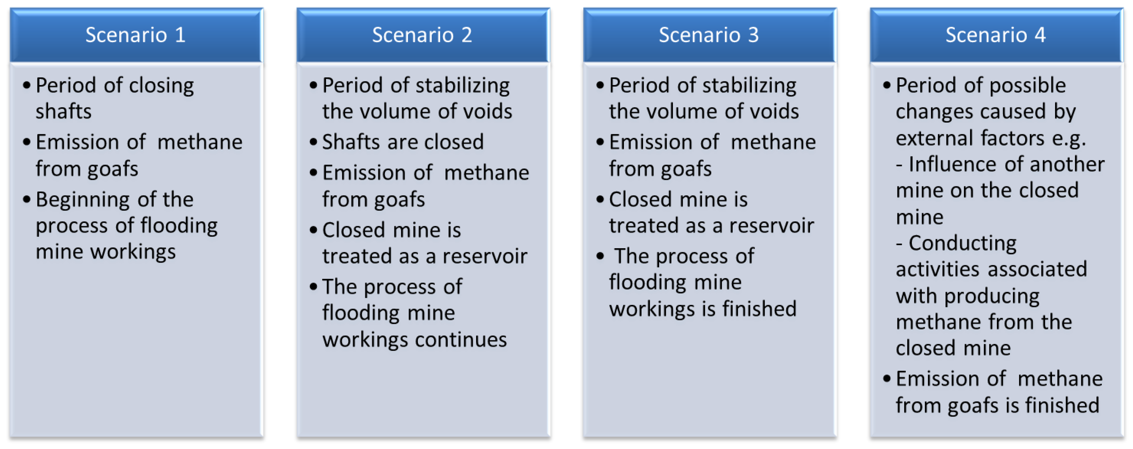
The analysis of how a gas hazard could be formed during a mine closure was divided into four scenarios,
Figure 2.
The article presents the applied methodology and the corresponding results obtained for scenario II, which is a key scenario for the closure process. In scenario II, changes in the volume of voids where methane accumulates were observed. The changes are caused by the ongoing process of flooding some parts of mine workings. The scenario covers the period from September 2018 until March 2020, with the following assumptions:
backfilling Chrobry I and Ryszard II shafts is completed, outflow of gases along them is impossible;
there is no ventilation connection between the workings of the Anna mine and the workings of the Rydułtowy mine;
mine workings and goafs of the Anna mine are being flooded by inflowing mine water and there are no dewatering operations. The overflow level has been reached;
water overflows along drainage dip heading R-part of the water floods workings and goafs, part of it is transported to the workings of the Rydułtowy mine and then is drained;
the assumed water inflow is constant and equals 0.4 m3/min.
The basis for the assumption of a constant value of the water inflow was the hydrological analysis of the Anna mine closure process. The measurements of the amount of water carried out on the drainage ditch in the Rydułtowy mine showed that the inflow level had stabilized and its values corresponded to the adopted value of 0.4 m3/min.
In the scenario, it is assumed that gas cannot outflow along the backfilled shafts, so the mine workings are treated as a gas reservoir, thus its volume is limited. This approach considers possible changes in the volume of voids caused by flooding the mine workings a well as the changes in methane concentration.
2. Methodology
Methane hazard analysis in the article concerns the mines where methane was emitted during mining operations. The main assumption is that the hazard analysis concerns the time after backfilling shafts and closing all the ventilation connections with other mines. It enables treating mine workings and voids of the closed mine as a reservoir [
16]. The amount of methane emitted into the assumed reservoir model depends mainly on the methane emission observed in longwalls when they were exploited, and the time passed since their closure. Within the framework of the conducted research, the following model of methane emission proposed by E. Krause was applied. The model is a result of many years of experiments and studies conducted in the Barbara experimental mine. Following the applied model [
17], the amount of methane emitted into mine workings is calculated with the formula:
where
represents the gas emission into a goaf from the relaxed undermined and overmined seams in the 15-year period following the termination of longwall mining operations, calculated separately for each year, expressed in m
3 CH
4/min;
reflects the average absolute methane emission in the life of a longwall when subject to the mining operation, in m
3 CH
4/min, and
u is the time passed since the mining operations ceased.
For a critical analysis of estimations regarding methane emissions into the sealed longwall goafs, a comparative analysis was carried out of the results produced in this model with the gas emission values from closed underground coal mines in Australia [
18], where long-term full range data are available. The absolute value of the difference shows a good fit of both models (
Table 1).
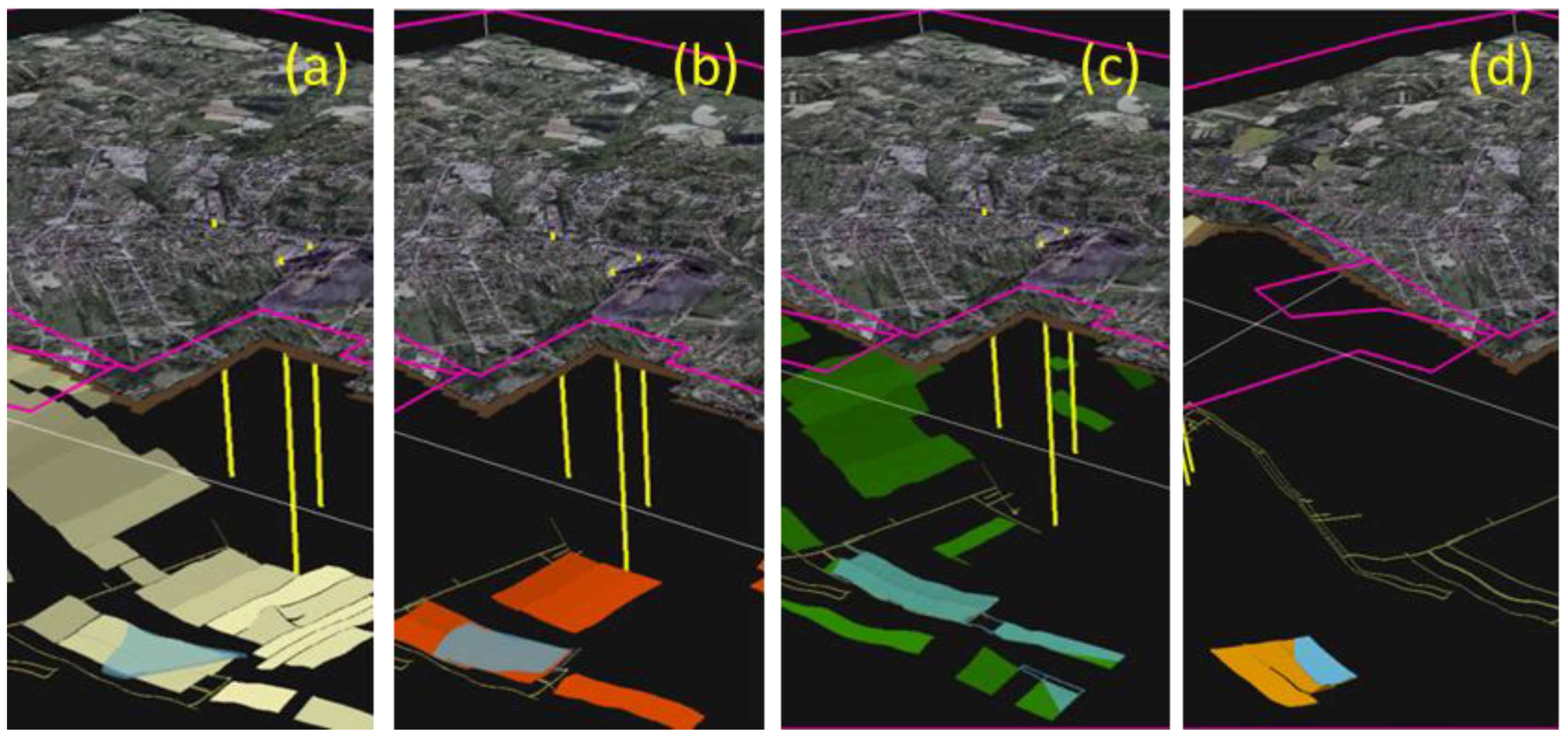
The validation results confirm that the assumptions made for the applied model were correct. To consider the influence of flooding goafs on the amount of emitted methane, it is necessary to identify areas which will be flooded. The areas to be flooded in the Anna mine were selected in seams 703, 707, 713, 719 (
Figure 3). The indicated flooded areas of the Anna mine (seam areas 703, 707, 713 and 718) were determined on the basis of geological, geodetic and hydrological analysis (seam depth, seam deposition, seam angle, location of water discharge to the Rydułtowy mine, water inflow). The flooded areas are those that are below the water level line after its stabilization (exceeding the overflow level) with the Rydułtowy mine. The other areas of the mine will not be flooded due to the fact that further water inflow will be (and is) entirely discharged to the Rydułtowy mine. For this reason, changing the amount of water inflow does not change the flooded areas. It only affects the rate of flooding of these areas—in the case of a greater inflow, they will be flooded earlier.
The Formula (1) presented above does not take into account the influence of water on methane emission and the fact that some seams will be flooded. Therefore, it is necessary to apply a modification (2) which takes into account the occurrence of this phenomenon and to introduce a division into flooded and non-flooded seams [
19].
where:
—forecasted methane emission into a goaf of i-th longwall
k1—coefficient of the surface area of flooded goafs of i-th longwall
k2—coefficient of methane emission into goafs of destressed seams within the destressed zone depending on the pressure of the water column.
Coefficient
k1 applied in the model corresponds with the share of flooded surface in a given area and it was calculated by comparing the surface of the flooded goafs with the surface of the longwall goafs
Coefficient k1 may assume values within the range of 0–1.
To determine
k2, it was necessary to conduct research into coal desorption from the analysed seams. The research focusing on the index of forecast methane desorption depending on the value of hydrostatic pressure of water column was conducted in the Barbara experimental mine of the Central Mining Institute. For the needs of developing the MERIDA project, the research was conducted in a test stand equipped with autoclaves. The detailed description of the tests is presented [
19].
Figure 4 presents the diagram of the test [
19].
The calculations conducted with Equations (1) and (2) enabled forecasts of the methane emission from the closed Anna mine, considering the influence of the flooded mine workings. To determine the changes in methane concentration, following the assumed model, the mine workings (voids) of the closed mine were treated as a gas reservoir [
16], where changes in volume are followed by changes in methane concentration. At the same time, the pressure is levelled off through microfracture in the rock mass and the areas near the shaft.
For a flooded mine the volume of inflowing methane is calculated with the formula:
where:
For the needs of the model, it was assumed that the amount of methane
QCH4 flows into voids of volume
Qv where there is a mixture of ideal gases under pressure
P0, at temperature
T. Assuming that the inflowing methane has constant temperature
T, and is under pressure
P0, the mass of inflowing methane equals:
where:
An increase in the pressure resulting from methane flowing into the volume of voids roughly equals:
and the ratio of the volume of methane flowing into the volume of voids is a coefficient of the pressure increase caused by methane emission from goafs and is calculated with Formula (7):
The concentration of methane in voids will change as 100% methane flows into them, following the formula:
where:
CpCH4—methane concentration [%],
Cpv—methane concentration in voids [%],
Qv—volume of voids [m3],
QCH4—volume of methane [m3].
Calculating changes in the concentration of methane in voids, for a given analysed period, e.g., a quarter, enables forecasts of the amount and the concentration of methane migrating towards the higher layers of the rock mass, assuming that, between the analysed periods, the pressure is constant i.e., the volume of inflowing 100% methane will push the same volume of gases out of the reservoir. The amount of methane of given concentration in a given period (
CpCH4) will be:
or, expressed as the amount of methane of 100% concentration, it will be:
where:
VGAS(CpCH4)—gas emission of Cp methane concentration,
VCH4(100%)—methane emission (100% concentration),
Qv—volume of voids [m3],
XCH4—coefficient of pressure increase caused by methane emission from goafs,
CpCH4—methane concentration [%],
t—time.
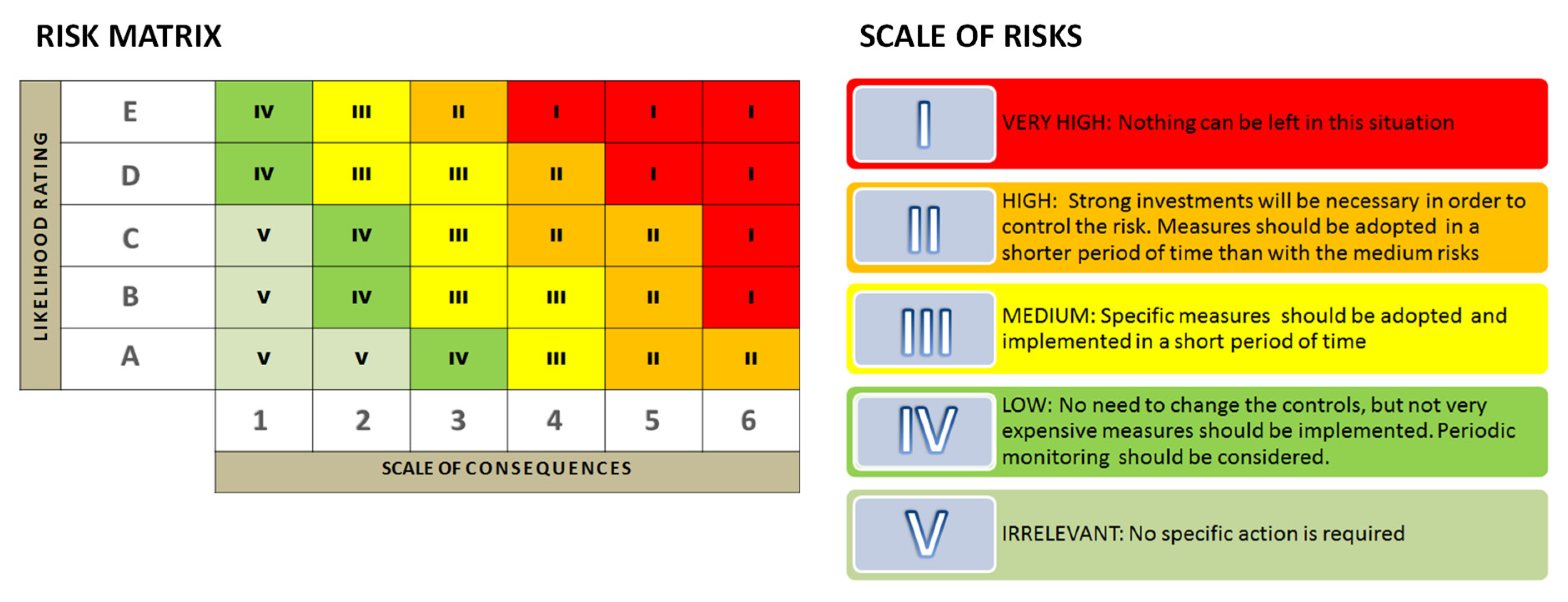
Calculating the amount of methane emitted into the mine voids and analysing its concentration in a given time (Stage) represent essential elements of the further process of risk assessment. To assess the risk, the MERIDA project employed a method compatible with the IEC/ISO 31010/2009 standard.
Figure 5 below presents the scale of the consequences and the likelihood rating.
After calculating the likelihood and consequences of a given hazard, the risk matrix is applied to determine its scale following the assumed method of interpreting results,
Figure 6.
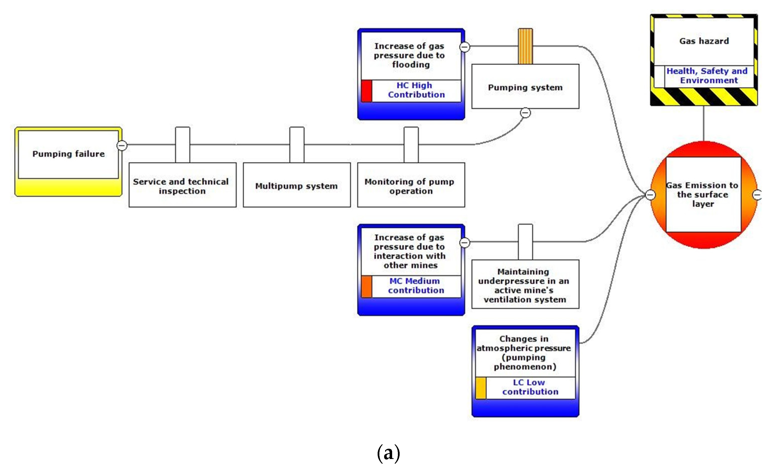
The analysis of the obtained results of methane emission, and the correlated changes in methane concentration in mine workings treated as a reservoir, enables an assessment of gas hazard within an area affected by post-mining influences of a closed hard coal mine. To identify the activities limiting the hazard, the BowTie method was applied analysing the cause and effect relationships.
The BowTie method is a risk assessment method that can be used to analyse risk scenarios. The essence of the method is a set of plausible risk scenarios with regard to a certain hazard and manners in which an organisation prevents those scenarios from happening. The BowTie, in risk assessment terms, is a graphical means of assessment which focuses on recognising specific cause and consequence pathways of such events, which enable identification of all the “pre-event” and “post-event” control measures and treatment options.
The BowTie method takes its name from the shape of the diagram created, which resembles a man’s bowtie. The BowTie method has several goals [
20]. It:
provides a structure to analyse a hazard systematically;
helps make a decision whether the current level of control is sufficient;
helps identify where and how to invest resources to have the greatest impact;
improves risk communication and awareness.
Building a BowTie diagram follows the steps and instructions below [
20]:
After creating a BowTie diagram, there are several methods to work out the barriers in more detail, if necessary. Furthermore, it is possible to indicate which barriers are critical and steps to be taken to secure their availability at all times.
The identified hazards and their consequences regarding gas emission to the surface are presented in (
Figure 7).
The hazards identified are: the increase in gas pressure due to mine flooding, the increase in gas pressure due to the interaction with other mines and the changes in the atmospheric pressure which cause a pumping phenomenon helping the gas to migrate to the surface.
Consequently, the greenhouse gases will either flow into the atmosphere or, in case that they do not reach the atmosphere, risks of suffocation or explosion in basements or while backfilling the shaft will occur.
3. Results and Discussion
According to the calculations undertaken following the methodology explained above, and due to the change of volume in voids caused by flooding during scenario II,
Table 2 presents the evolution of the volume of mine workings as the inflowing water increases, as well as the volume of methane.
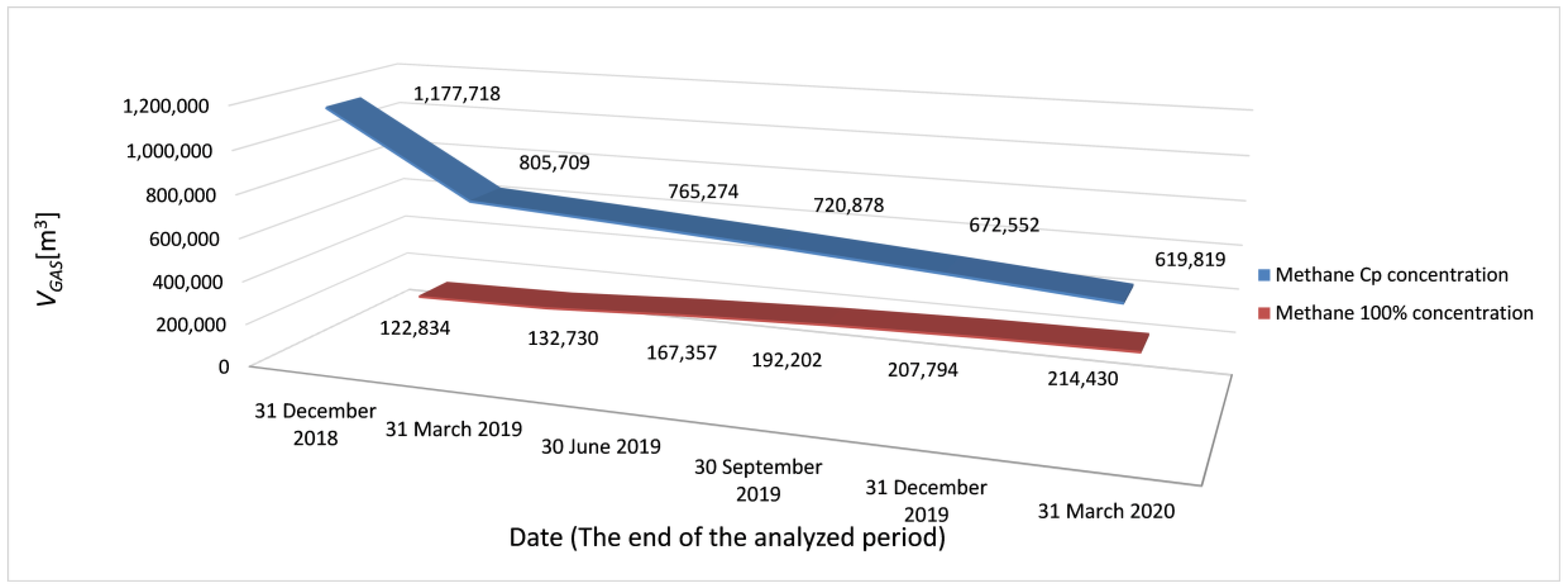
Figure 8 shows the changes in the methane concentration with a continuous increase, up to the maximum value of 34.60%.
Taking this into consideration,
Figure 9 presents the volume of methane migrating to the near-surface layers, expressed in m
3 of CH
4 with 100% concentration and in m
3 with their respective CH
4 concentrations. The presented diagram aims to show the difference between the volume of methane with a concentration of 100% and methane with a concentration of
Cp. Methane of the approximate
Cp concentration will migrate to the surface layers. The mixture of methane and mine air will not be homogeneous in every mine site. The large number of variables prevents accurate calculation of the methane concentration for a selected mine site.
For coal mines, the areas prone to gas migration to the surface are those of shallow exploitation, closed shafts, and faults occurring in the areas where methane may concentrate in mine voids. To undertake the analysis of possible gas migration to the surface, it is necessary to consider the permeability of the overburden.
The map of the carboniferous overburden in the Anna mine area is presented in
Figure 10. The location of the Anna mine has been marked with the mining symbol, as well as the contour marked in red.
The conducted analysis showed that the probability of gas migration to the surface in fault areas is low, due to the impermeable or lowly permeable layers located over the fault edges. The highest risk is associated with the areas of shallow exploitation and shafts Ryszard II, Chrobry I and Chrobry II, closed during the final stages of the mine closure.
Assessment of risk associated with methane migration to the surface and methane explosion was estimated by means of a risk assessment matrix. The likelihood rating selected was possible as it may occur at some time, and the consequence rating was considered as moderate, meaning a significant impact with a possible loss between €60,000 and €300,000. The combination of both factors allows a medium risk to be estimated. Thus, specific measures should be adopted and implemented in a short period of time.
The final result of the work is a map presenting the areas at risk of gas migration to the surface (
Figure 11) and
Table 3 presents the geographical coordinates of the shafts shown in
Figure 11.
The results presented in form of the maps allow us to consider actions to lower the risks. Regarding gas risk assessment, the hazard associated with the emission of gases to the surface during and after a mine closure depends mainly on the amount of the gases in mine workings and the occurrence of structures and areas which enable migration of the gases to the surface.
With the focus on the emission of gases to the surface, due to the presence of faults in the area, the permeability of the Carboniferous overburden located above was analysed. The analysis shows that only virtually impermeable and low permeable geological formations were present in the area (impermeable and low permeable layers). Following the above evaluation and analyses, the gas risk in the area of the Jedłownicki drift was determined to be low. Thus, it is not necessary to change the controls, however some low-cost measures should be considered.
Flares, gas vents or a gas engine may be applied as a proposed treatment, depending on the results of the measured methane concentrations in the shaft and the gas pressure [
12,
13].
To minimise the explosion risk for the area of the Ryszard II shaft, it is necessary to prohibit construction of buildings within 20 metres of the closed shaft. In the area of shallow exploitation, it is necessary to demarcate a zone expanding by 20 metres from the border of shallow exploitation and to make it obligatory to apply gas leak detectors in the basements of the buildings located there. There are 25 buildings in the risk area where gas leak detectors should be installed [
7].
4. Conclusions
The closure process of underground coal mines entails specific gas risks which require careful liquidation methodology, including the implementation of relevant mitigation procedures to identify the key hazards both to the environment and humans.
Methane is a greenhouse gas having a particularly negative effect when it migrates into the environment, as considering a 20-year period, the effect of methane on global warming can be estimated as 84 times greater than that of CO2. On the other hand, it may reach dangerous concentrations in the ground floor areas and basements of buildings as well as in areas where mine closure works are conducted, which may lead to intoxication, asphyxia or even explosions, the risk of the latter rising with methane concentration of between 5% and 15%.
This paper presented a risk analysis of methane hazard occurring at the final stage of the closure process of a Polish underground mine. It applies a methane emission model created jointly by the National Institute for the Environment and Industrial Hazards (INERIS) in France and the Central Mining Institute (GIG) in Poland. The analyses and measurements carried out for this paper were conducted within the framework of the MERIDA project. The subject of the study included: the flooding process and how it affects the scale of gas emission from goafs, changes in methane concentration, and changes in the volume of voids.
Moreover, these forecasts also serve to address feasibility studies on methane recovery opportunities at the same time preventing the methane escaping to the atmosphere, something that will inevitably occur as methane is less dense than air, and geological structures are never perfectly airtight traps. The research allowed the amount of methane that migrates to the near-surface layers as well as its concentration during the post-closure period to be determined. Methane migrates to the surface mainly through coal layers outcrops, faults, permeable layers and through the pits of the mines. Given that geological structures never form perfectly airtight traps and the fact that methane is less dense than air, most of it will eventually be liberated into the atmosphere.
Taking all of these questions into consideration, it is possible to map the areas prone to safety risks related to methane migration in order to implement specific measures to reduce the methane risk. To undertake the analysis of possible gas migration to the surface, it is necessary to consider the permeability of the overburden.
The measures to be undertaken include the use of leak detectors in the basements of buildings within the risk areas as well as the prohibition against building new constructions in these areas.
On the other hand, and in order to reduce the amount of methane liberated into the atmosphere, the possible application of AMM technologies such as flares, vent flares or suctioning vents for gas engines should be taken into consideration. AMM technologies enable the risk of uncontrolled emissions at the surface to be reduced, although they do not eliminate it, exploiting an otherwise wasted gas resource and mitigating GHG emissions. This approach complies with the guidelines of the United Nations Economic Commission for Europe [
21].
Finally, one important drawback in the methodology applied to estimate the amount of methane emission to the atmosphere must be mentioned. The model requires as input the monthly methane emission in all the active longwalls of the mines in the period of 15 years previous to the decommissioning starting date. Moreover, data on the water inflow and flooding levels must be considered. The absence of those data prevents the estimation of the amount of methane to emissions to the atmosphere. Nevertheless, the elaboration of the map of risk areas is still possible.
The methodology presented in this paper can be applied to any underground coal mine in the course of the closure process. Indeed, the MERIDA project used this methodology in two very different types of underground coal mines: Polish coal mines with sub-horizontal seams exploited by longwall panels, and Spanish coal mines with sub-vertical seams exploited by the sub-level caving method.
The presented method allows us to indicate the zones of gas hazard in the area of potential methane emissions on the surface. The method is dedicated primarily for mines closed by means of flooding workings and closing shafts. For such mines, it is essential that the proposed method be applied already at the initial part of the liquidation process. The method may also be applied to analyse the amount of methane in a closed mine in the decision process regarding its potential exploitation for industrial use. The results obtained may be useful for local authorities when creating local land development plans to delineate hazardous zones.


