Article

Low Enthalpy Geothermal Resources for Local Sustainable Development: A Case Study in Poland

by
Aleksandra Szulc-Wrońska
* and
Barbara Tomaszewska
Department of Fossil Fuels, Faculty of Geology, Geophysics and Environmental Protection, AGH University of Science and Technology, 30-059 Kraków, Poland
*
Author to whom correspondence should be addressed.
Energies 2020, 13(19), 5010; https://doi.org/10.3390/en13195010
Submission received: 16 July 2020 / Revised: 18 September 2020 / Accepted: 22 September 2020 / Published: 23 September 2020
(This article belongs to the Special Issue Assessment, Management and Treatment of Waters and Geothermal Systems)

Abstract

:
Many regions in Poland face the problem of air pollution. These regions include, though are not exclusive, to health resorts, an important element of the healthcare industry. Poor air quality is mainly associated with the domestic sector, which is dominated by individual solid fuel and coal boilers. One option for reducing emissions is to use alternative energy sources for heating purposes. Therefore, the paper presents an analysis into the possibility of using low enthalpy (low temperature) geothermal energy in health resort areas. The main purpose of the article is to estimate the potential of soil and water as the lower source for a heat pump. The article presents analyses of geological and hydrogeological conditions based on which the thermal parameters of the rock mass were determined, which were thermal conductivity and unit heat output for 1800 operating hours per year. The calculated values were used to perform a spatial analysis of the data and create maps of the average thermal conductivity for horizontal ground heat exchangers (HGHE) to a depth of 2 and 10 m and vertical ground heat exchangers (VGHE) in depth ranges up to 30, 60, and 90 m. The heating power of the intakes, located in the research area, were estimated using empirical formulas. In addition, a detailed analysis of the physicochemical parameters of groundwater in terms of the requirements indicated by four heat pump manufacturers is presented. The results of the presented research makes it possible to assess the potential of low-temperature geothermal energy and to characterize the suitability of the selected location for the use of HGHE, VGHE, and wells. As a result, the discussed area was found to have a high potential for the use of ground source heat pumps and a moderate potential for the use of low-temperature systems based on groundwater.

1. Introduction

The use of energy from renewable sources is one of the priorities of the European Union (EU) energy policy. Renewable energy sources (RES), in the face of continuous climate change, are fundamental to reducing greenhouse gas emissions [1,2]. Locally, they also have a significant impact on the improvement of air quality [3,4]. In addition, they form an integral part of local sustainable development, which plays an important role in the daily life of society.
Poland is an EU member state that has been struggling with air pollution for many years. According to data from the European Environmental Agency (EEA), the highest concentrations and breaches of the permissible levels were observed for particulate matter PM10 and PM2.5 and benzo(a)pyrene (B(a)P) in 2017 [5]. Exceedance of the daily limit value of PM10 (50 µg/m3) was recorded at all stations located in the central and southern parts of the country with an annual average of 60.2 µg/m3 in 2017 across the whole country. Annual limit values of PM10 and PM2.5 were not exceeded nationwide, however they were recorded locally (stations in the south of the country). The biggest problem concerns the average annual concentration of B(a)P (EU target value 1 ng/m3), which has been exceeded for many years throughout the country with an annual average for the country of 4.8 ng/m3 in 2017 [5,6].
Poor air quality also affects health resort areas, which in Poland form an integral part of the healthcare industry. Treatment in these areas is based on the use of natural minerals and clean climate. Therefore, the Rabka-Zdrój health resort, located in the southern part of Poland, was chosen as a testing ground. The resort, for several years, has had a significant problem with high concentrations of PM10 and B(a)P, often accompanied by the phenomenon of ground-level emissions. The main reason for these emissions is the combustion of solid fuels and the production of domestic hot water in households. Furthermore, unfavorable meteorological conditions (such as temperature inversion, low wind speed, the high number of days with atmospheric calm), and the topography (location in a valley surrounded on three sides by hills) intensify air pollution. The goal of the present research is to develop solutions based on renewable energy sources, whose increased use would reduce pollutant emissions from domestic households and improve the quality of air at the health resort. The study analyzed the low enthalpy geothermal potential and the possibility of using solutions based on groundwater and obtaining heat from the earth.

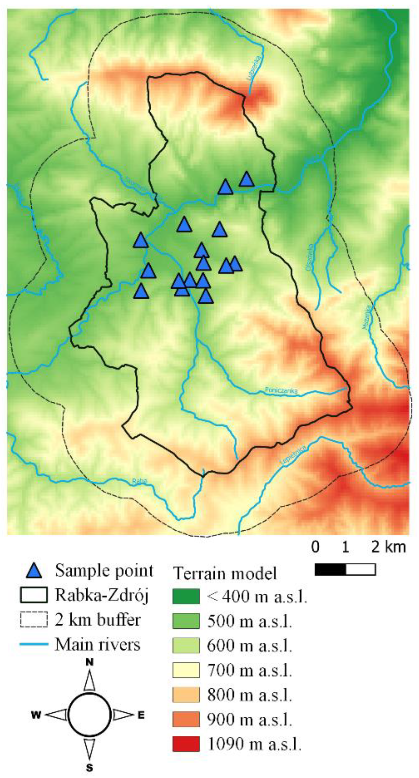
2. Characteristics of the Research Area

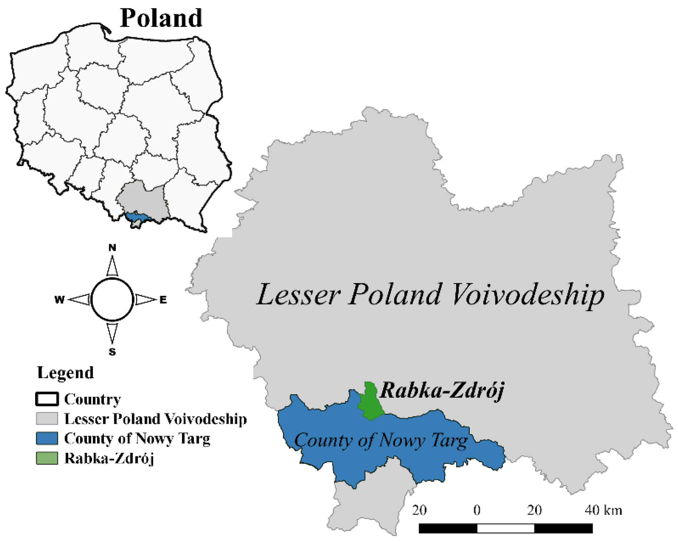
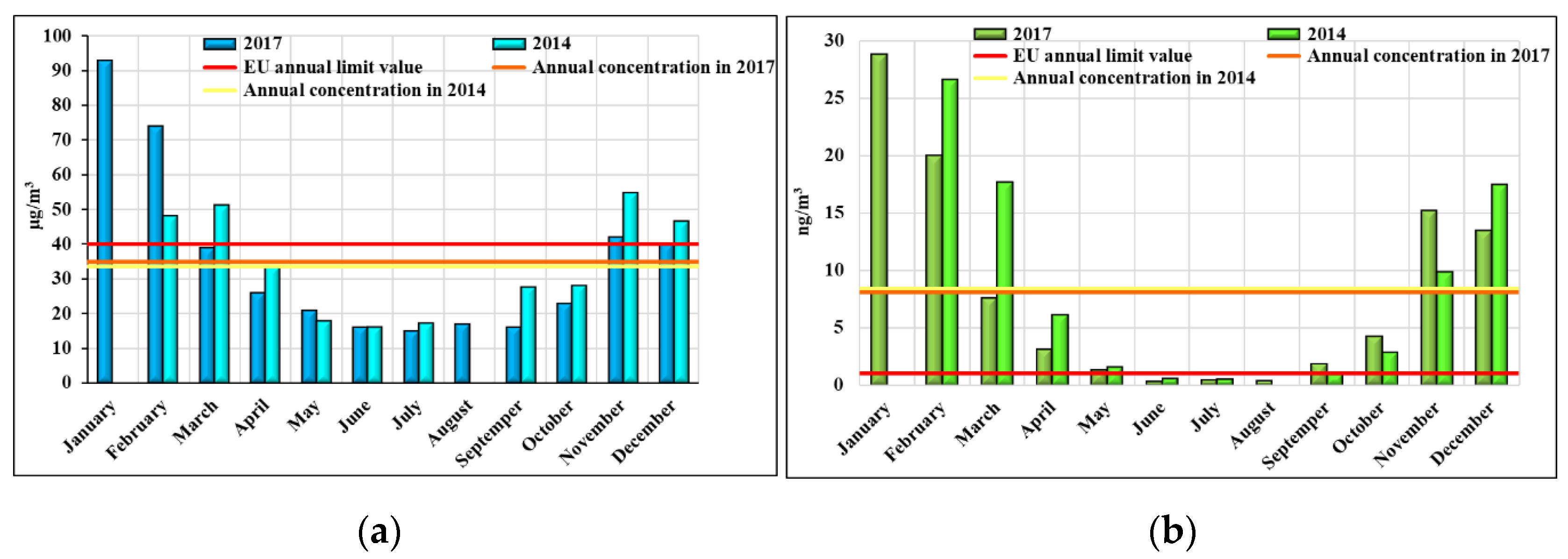
2.1. Location and Climatic Conditions

Rabka-Zdrój is a mountain health resort situated in the southern part of Poland (49°37′ N, 19°58′ E) (Figure 1).
The municipality has possessed the status of a health resort since 1967. According to Polish law, an area that has been granted such a status has to meet a total of five conditions, which include deposits of natural healing minerals and a climate with proven healing properties [7]. Healing waters are the source of the natural healing minerals found in Rabka-Zdrój including sodium chloride-rich mineral waters containing iodides and bromides [8,9]. These are used in the treatment of orthopedic-traumatic diseases, cardiovascular diseases and hypertension, upper and lower respiratory tract diseases, diabetes and skin diseases [10]. A selection of meteorological parameters is presented in Table 1.
The area of the health resort is not subject to constant air monitoring. Air quality tests take place ad hoc in different years and cover the concentration measurements for B(a)P, PM10, NO2, and SO2. The results obtained from the monitoring station located in Rabka-Zdrój in 2014 and 2017 indicate very high concentrations of B(a)P in the autumn–winter period, which in Poland means the heating season. The average annual concentration of B(a)P in both cases is about 8 ng/m3, which is eight times the permissible level of 1 ng/m3 specified by the European Union [12] (Figure 2). The permissible annual concentration of PM10 (40 µg/m3) was not exceeded. However, in 2014 and 2017, values close to the limit were reached, amounting to 33.5 and 35 µg/m3, respectively. In addition, in 2017, 66 days were recorded where the permissible daily concentration of PM10 (50 µg/m3) was exceeded, with a permissible value of 35 days [13]. In 2014, the target value of the daily concentration of PM10 was not exceeded. The majority of days, where thePM10 levels were exceeded, was recorded from October to March. The above data indicates a relationship between air quality and the heating of buildings, most often with the use of inefficient heating devices and poor quality solid fuels [14,15].

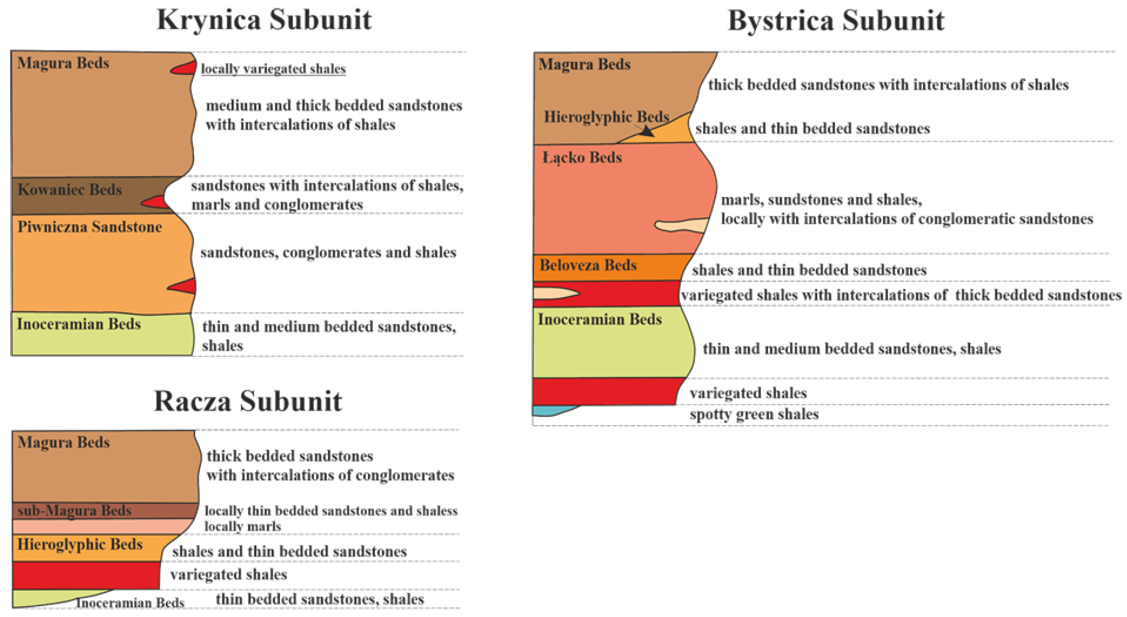
2.2. Geological Structure

The research area is located in the Outer Carpathians, also known as the Flysch Carpathians, and is characterized by a complex geological structure. Between 1925–1927, nine boreholes were drilled including seven hydrogeological boreholes However, their documentation is incomplete. Detailed exploration of the geological record was made possible only by deep structural, exploratory, and hydrogeological drilling in the 1970s and 1980s [17]. The research area consists mainly of folded flysch and Quaternary deposits. The highest structural unit in the Rabka-Zdrój region is the Magura nappe covering Cretaceous-Paleogene formations.
The oldest deposits of the Magura nappe are alb-cenoman spotty green shales and cenoman-turon variegated shales exposed to the east of Rabka. Higher in the profile there are Inoceramian beds of the Senon-Paleocene age, developed as thin, medium, and thick-bedded sandstone-shale series [18]. Due to the facial diversity, the Paleogene formations were divided into four tectonic-facies subunits: Siary (Su), Racza (Ra), Bystrica (Bu), and Krynica (Ku) [19,20,21,22,23].
Three of them were found in the area of the present study, from the north these are: the Racza subunit, the Bystrica subunit, and the Krynica subunit [24]. In the Racza subunit, above the Senon deposits, shales were observed to have developed, being covered with Hieroglyphic beds with a thickness of about 150 m. Hieroglyphic beds (middle Eocene) mainly form gray-green shales with thin-bedded calcareous-silicon sandstones. The predominant deposits of the Racza subunit are Upper Eocene thick-bedded sandstones with intercalations of conglomerate and shale (Figure 3). In the Bystrica subunit, the profile of Paleogene formations begins with shale, with thick-bedded sandstone intercalations in the central part of the study area. Above, in the Lower and Middle Eocene, the Beloveza beds (shales, thin-bedded sandstones) and Łącko beds (marls, sandstones, shales) developed, respectively. In these beds, the presence of mineral waters was found by seven boreholes [25,26]. Above the Beloveza and Łącko beds, as in the Racza subunit, there are Hieroglyphic beds covered by the Magura beds. Along the northern part of the study area, the Krynica subunit formations are exposed. The dominant complexes are thick-bedded sandstones from Piwniczna and Magura sandstones [27]. Between them, the Kowaniec beds (Middle Eocene) developed. These consist of not only sandstones, but also thicker intercalations of marls, shales, and conglomerates. All the deposits representing Paleogen have local variegated slate intercalations [28].
The youngest deposits of the testing ground are those from the Quaternary age, forming a discontinuous cover of varied thickness over the older (Cretaceous–Tertiary) deposits. Pleistocene formations in the study area developed as gravels, sands, and river clays of erosion and accumulation terraces [29]. The sediments of the oldest South Polish glaciation created terraces of 15–25 m above the river level, formed between the Skomielny and Luboński streams as well as in the area between Raba, Poniczanka, and Słonka. The deposits created during the Middle Polish glaciation formed terraces of 5–9 m above the river level (the area around the mouth of the Słonka and Poniczanka streams and flowing down from Luboń to Raba). Respectively, the height of terraces created during the North Polish glaciation reached 2.5–7 m above the river level (the region of the upper course of the Raba river with areas of larger tributaries) [18]. Loess-like, diluvial and eluvial clays with rock debris (locally located on the Raba River around the center of Rabka-Zdrój) are locally found in the analyzed area as well as blocks, rock debris, clays, and colluvial sands (associated with mass movements). Holocene gravels, sands, and alluvial mud aggregates appear in the Raba Valley and its tributaries [29].

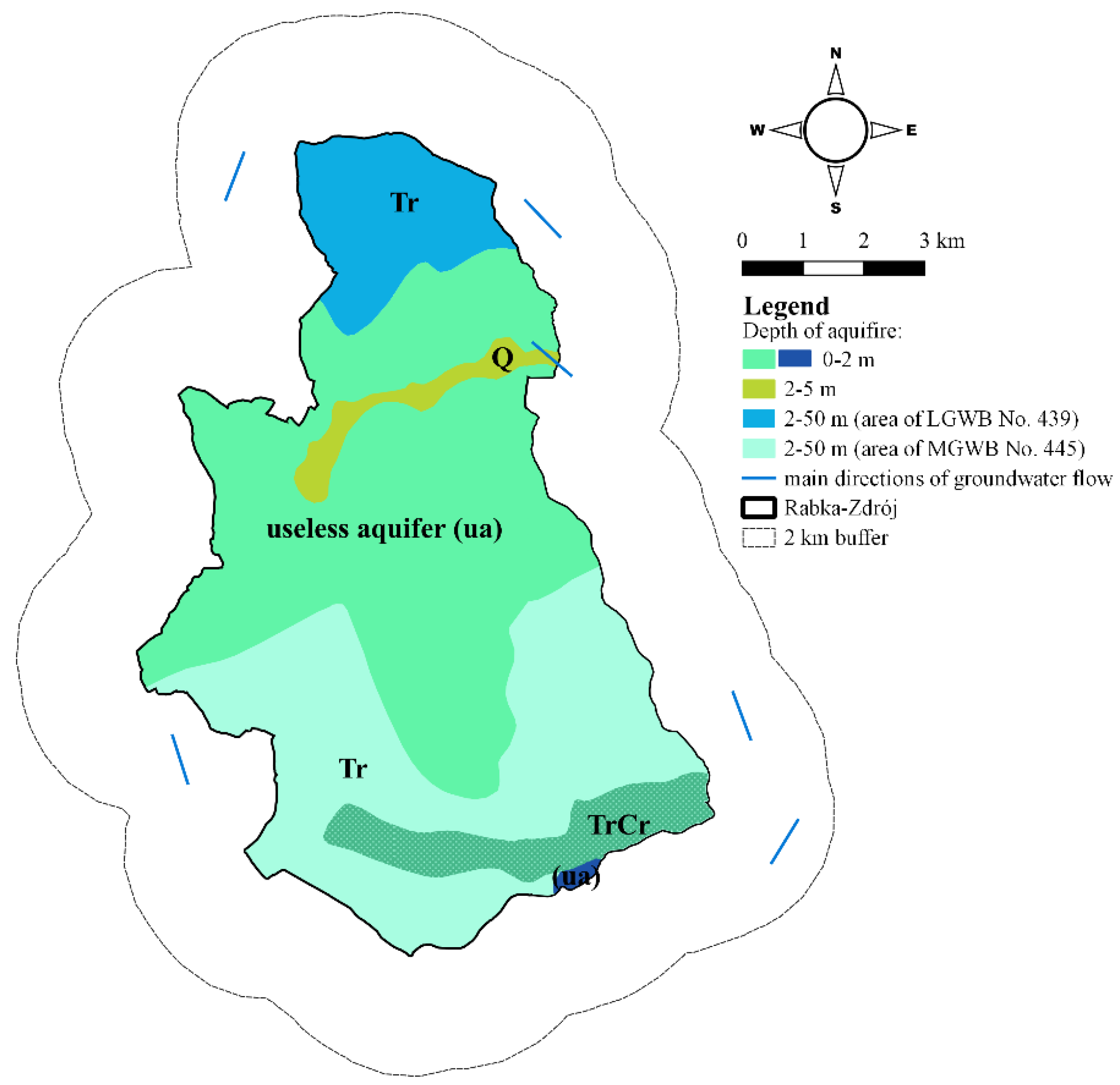
2.3. Hydrogeological Conditions

According to the latest regional division of ordinary groundwater in Poland [30], the research area belongs to the southern macro-region and includes the Carpathian Region of the mountain province (sub-region of the Outer Carpathians). This division refers to earlier studies presented by Paczyński and Kleczkowski [31,32]. Fragments of two Tertiary main and local groundwater bodies occur in the study area. In the northern part, there is the MGWB No. 439 Magura bed water reservoir (the Gorce Mountains), while in the southern part, there is the LGWB No. 445 Magura bed water reservoir (Babia Góra mountain)—formerly MGWB No. 445 (Figure 4) [33]. In the area, there is a fracture-pore aquifer in flysch (Cretaceous–Palaeogene) deposits and a pore aquifer in Quaternary deposits [34]. In the Quaternary deposits, the conductivity of the aquifer is 0.83–12.5 m2/h, and the filtration coefficient is 3.6·10−1–3.6·10−4 m/h. In the Cretaceous–Paleogene deposits, aquifers occur up to a depth of 78 m and are characterized by a filtration coefficient of 3.6·10−2–3.6·10−3 m/h [35].
The Quaternary aquifer is formed by sandstone and gravel sediments of a river origin with a thickness not exceeding 10 m. This level is fed mainly by the infiltration of atmospheric precipitation and surface waters. In the Raba River Valley, the thickness of the aquifer is up to 4.8 m, and in the valleys of its tributaries, it does not exceed 2 m (Figure 4) [36]. The potential capacity of a well is defined as within 2–5 m3/h. The water table stabilizes at a depth of 2–5 m. In the central part of Rabka-Zdrój (the area of alluvial fans), the hydrogeological conditions slightly change. The potential capacity of a well is lower (0.5–1.5 m3/h), and the confined groundwater surface is found at a depth of 6–11 m [37]. The aquifers of the flysch formation of the Magura unit are characterized by thick- and medium-bedded sandstones with shale intercalations [25,38]. In the flysch beds of Rabka-Zdrój, the co-occurrence of mineral and ordinary waters have been observed [39]. In the northern part of the research area in the Racza unit, aquifers occur in the Hieroglyphic beds, the Magura beds, and also locally in sub-Magura beds. In the central part of the research area, aquifers are associated with the Inoceramian beds as well as the Łącko, Beloveza (Sądecki unit), and Krosno beds (the Grybów and Dukla units). Further south, aquifers occur in the Inoceramian beds as well as in the Piwniczna sandstones of the Krynica unit [37]. The direct supply of the Tertiary beds occurs via the infiltration of precipitation. The main groundwater flows run toward the Raba River Valley and locally toward smaller streams [36]. In the analyzed area, there were also zones characterized by the lack of a usable aquifer [40]. This situation usually occurs when there are more shale layers than sandstone formations.

3. Materials and Methods

In order to assess the potential of low-temperature geothermal energy, a number of available databases containing geological and hydrogeological information have been used. To analyze the possibility of obtaining ground-source heat, data published and made available by the Polish Geological Institute (PGI) was used. This included the Central Geological Database (CBDG) from which information on boreholes located in the research area was obtained as well as the Central Hydrogeological Database (CBDH) from which information on hydrogeological wells and groundwater intakes was obtained. Detailed data concerning aquifers, lithological profiles of boreholes, and the efficiency of aquifers were included. In the process of the data analysis, the Detailed Geological Map of Poland, the Hydrogeological Map of Poland, and the Geoenvironmental Map of Poland were also used as well as available explanations, which provided a source of additional and more detailed information. The analyses was supplemented with publicly available PGI digital and spatial data resources and other open public data [41,42].

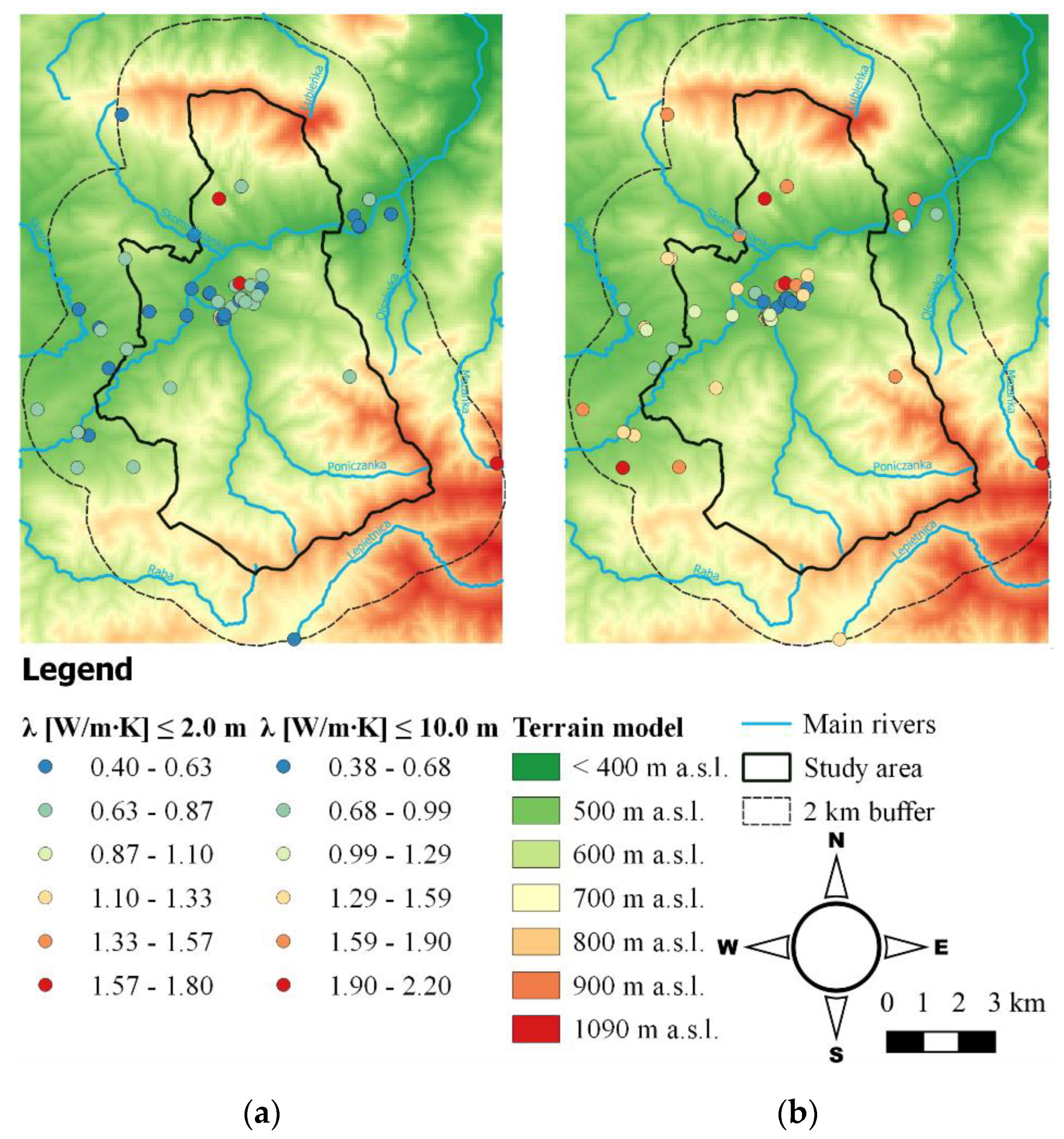
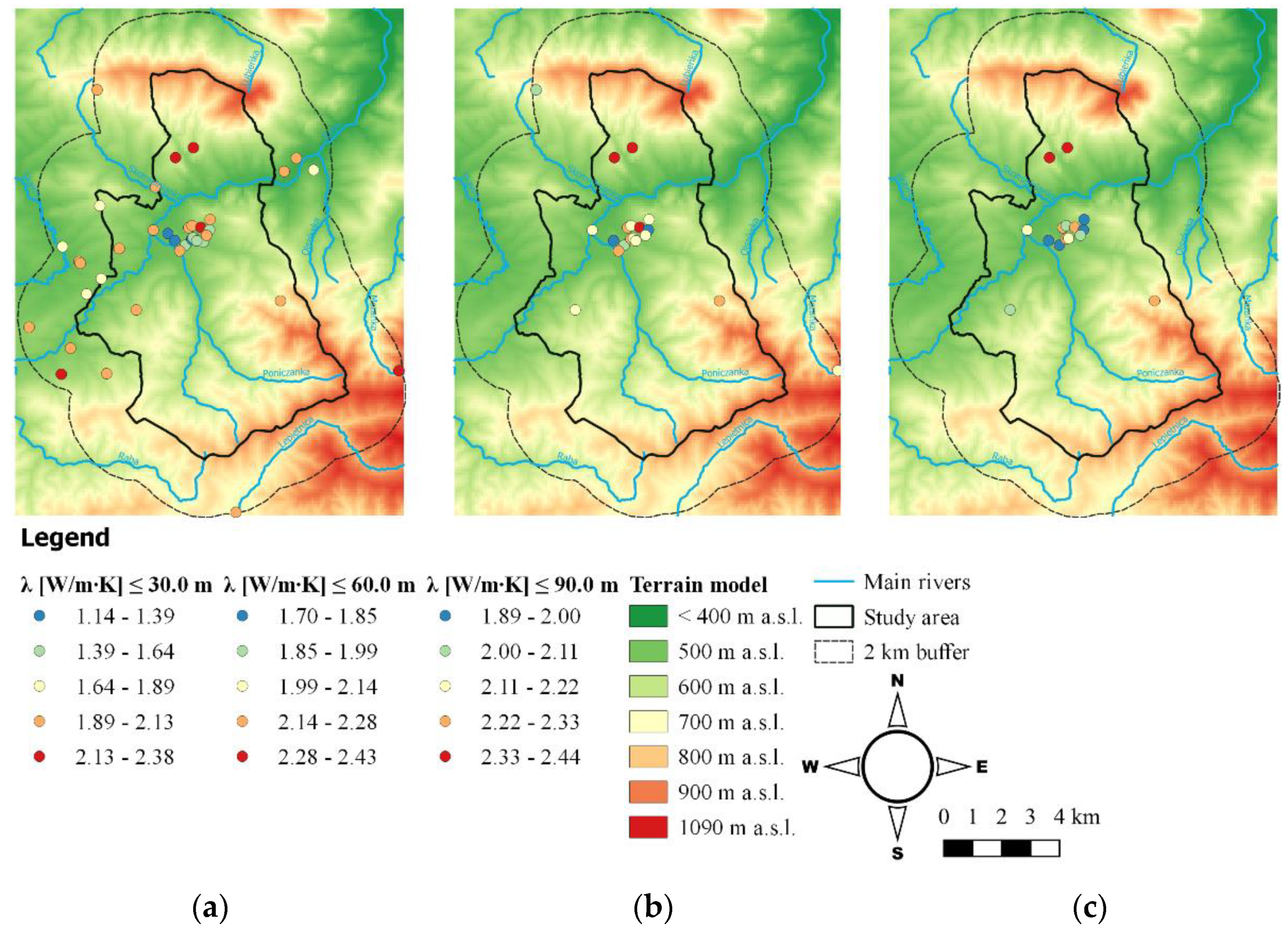
3.1. Methods of Using the Earth’s Heat as a Lower Heat Source for Heat Pumps

The first stage of the study was to analyze the possibility of using ground-source heat for households with vertical and horizontal ground heat exchangers. For this purpose, lithological profiles were used for boreholes located in Rabka-Zdrój. In addition, in order to expand the analysis of the selected area, it was decided to appoint a buffer zone with a radius of 2 km and use the available borehole data from the immediate vicinity of administrative boundaries (Figure 5). Based on the lithological profiles, the basic geothermal properties of rocks and soils were identified. The weight average values of thermal conductivity λ [W/m∙K] and unit heat efficiency qv [W/m] or [W/m2] for 1800 operating hours per year, were calculated in depth ranges up to 30, 60, and 90 m:
λ = i = 1 n u i   ·   λ i i = 1 n u i
where λ is the weight average of the thermal conductivity coefficient [W/m∙K]; ui is the thickness of individual precipitates in the lithological profile [m]; and λi is the thermal conductivity coefficient of individual precipitates in the lithological profile [W/m∙K].
q v = i = 1 n u i   ·   q i i = 1 n u i
where qv is the weight average of the unit heat efficiency [W/m] or [W/m2]; ui is the thickness of individual precipitates in the lithological profile [m]; and qi is the unit heat efficiency of individual precipitates in the lithological profile [W/m∙K].
Heat conduction coefficients and the unit heat efficiency for individual lithological precipitates were adopted based on the literature data, also taking into account the moisture content of the deposits. For sandstones, mudstones, and claystones, the coefficients were determined based on measurements of rock samples presented by Sroka and Plewa [43,44]. Recommended coefficients were used for other deposits obtained by combining the results of measurements performed as part of the Cheap and Efficient Application of Reliable Ground Source Heat Exchangers and Pumps (Cheap-GSHPs) project with results reported in the literature [45]. The missing coefficients, for example, for shale, were adopted from the Verein Deutscher Ingenieure (VDI) 4640-1 guidelines [46] and Polish Organization for the Development of Heat Pump Technology (PORT PC) [47]. The unit heat output coefficients were adopted in accordance with Sanner [48] for vertical ground heat exchangers and the VDI 4640-2 guidelines [49] for horizontal ground heat exchangers. Based on the results obtained for the average value of the thermal conductivity λ [W/m∙K], a spatial analysis was performed using Geographic Information System (GIS) tools. Low-temperature energy potential maps up to depth intervals of 2 and 10 m were developed for horizontal heat exchangers and 30, 60, and 90 m for vertical heat exchangers.

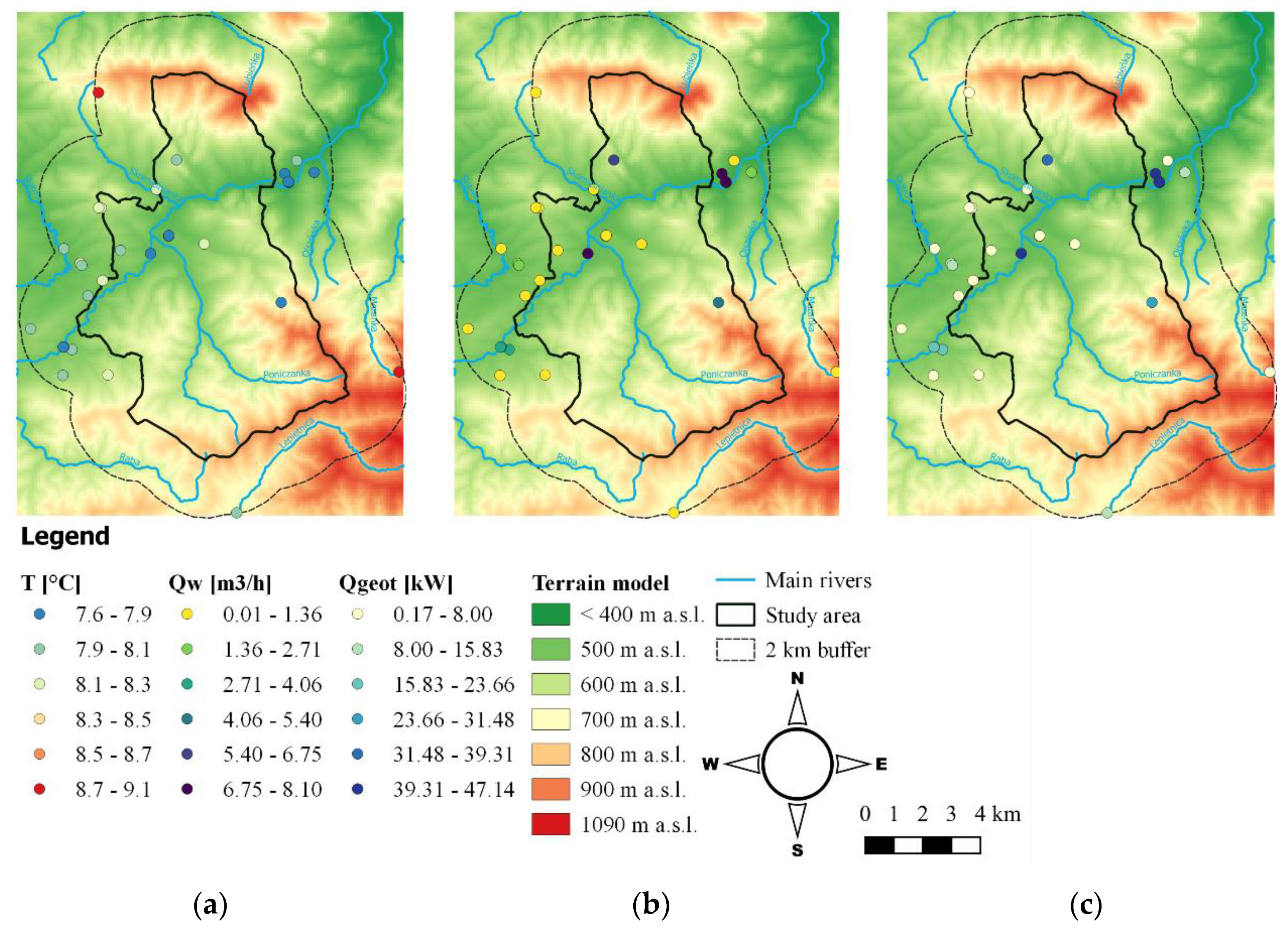
3.2. Methods of Using Groundwater as a Lower Heat Source for Heat Pumps
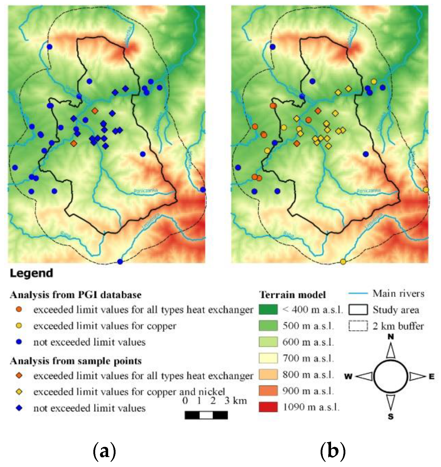
The second stage of the study was to analyze the possibility of using groundwater for households as a lower heat source for low-temperature systems supported by heat pumps. As in the previous stage (3.1.), it was decided to extend the research area to a buffer zone with a radius of 2 km (Figure 5). The basic parameter for determining the energy potential of groundwater was the heating power of its intakes. Its estimated value was calculated for all of the analyzed intakes based on the following formula [50]:
Qgeot = Qw · ρw · cw · (Tw − Tz)
where Qgeot is the heating power of the intake [kW]; Qw is the efficiency of the intake [m3/s]; Ρw is the water density, which was set at 1000 (kg/m3); cw is the specific heat of the water (set at 4,19 kJ/(kg·°C)); Tw is the water temperature at the head (°C); and Tz is the temperature of the cooled water (temperature at the outlet of the heat pump) (°C).
The efficiency of individual intakes was adopted based on data obtained from the Polish Hydrogeological Survey (PHS) [51] The water temperature at the head was adopted as the temperature of water taken from individual intakes. During the data verification stage, it was found that nine of the analyzed intakes had data concerning water temperature. For the other intakes, it was decided to calculate the estimated water temperature using the formula [52,53]:
T = tavg + A + (H − h)/g
where T is the water temperature at the depth of H (°C); tavg is the average annual air temperature (°C) [54]; A is a constant depending on the height above sea level [52,53]; H is the depth of the occurrence of water (m); h is the depth of the constant temperature zone (m); and g is the geothermal degree (m) [38].
Furthermore, to estimate the error of the calculation, the measured water temperature was compared with the results of Equation (4). Due to the relatively shallow occurrence of groundwater, heat losses associated with flow to the surface were omitted. In addition, it was assumed that the water, after passing through the heat pump, was cooled by 5 °C [55,56,57]. Based on the results obtained, a map was made for the estimated heating power of the intakes in the research area.
The physicochemical properties of the water were also analyzed in terms of the possibility of their use in low-temperature installations based on heat pumps. Preliminary verification of data obtained for the intakes suggest that in most cases, the physicochemical analyses were incomplete and related to only a few parameters important for the use of groundwater in heat pumps. Ultimately, it was decided to use the available analyses, however, they were expanded to include an additional 16 analyses of water samples, which were collected in the city of Rabka-Zdrój as part of the authors’ own field tests (Figure 5). Water samples from the wells were collected in accordance with the guidelines described in the PN-ISO 5667-11: 2017-10 Standard [58]. The samples were delivered to the laboratory within 24 h. The physicochemical analysis of water was run at the accredited Hydrogeochemical Laboratory of the Hydrogeology and Engineering Geology Department of the AGH University of Science and Technology in Cracow (PCA accreditation certificate No. AB 1050). Based on the results of the physicochemical analyses, water quality was assessed in relation to the guidelines of selected heat pump manufacturers: Viessmann Sp. z o.o.; Dimplex Sp. z o.o.; Vaillant Saunier Duval Sp. z o.o.; and Ochsner Wärmepumpen GmbH [59,60,61,62], (Table 2).

4. Results

4.1. Ground-Source Heat as a Lower Heat Source for Heat Pumps

For shallow depths, an analysis of the average thermal parameters of the rock mass, up to a depth of 2 and 10 m, was conducted, these depths usually being dedicated to horizontal or basket heat exchangers. The dominant sediments up to a depth of 2 m are dry clays and gravels with an average thermal conductivity of 0.4–0.64 W/m∙K (Figure 6). The occurrence of waterlogged gravel was defined in several boreholes and their thermal conductivity was above 1.6 W/m∙K. For most of the deposits up to 10 m, an increase in average thermal conductivity was noted. The highest values of λ: 1.9–2.2 W/m∙K are most often associated with the occurrence of an irrigated sandstone layer. The unit heat output values qv ranged between 10 W/m2 in the dry, unbound substrate and up to 40 W/m2 in the substrate saturated with water (sand, gravel).
For medium depths, the characteristics of the thermal parameters of rock mass to a depth of 30, 60, and 90 m are presented, which were used to assess the possibility of using vertical ground heat exchangers in the households. The weighted thermal conductivity coefficient varied from 1.14 to 2.38, 1.70 to 2.43, and 1.89 to 2.44 for the depths of 30, 60, and 90 m, respectively (Figure 7). High thermal conductivity of the rock substrate (≥2 W/m∙K) characterized 41.0% of the boreholes to a depth of 30 m and about 80.0% of the boreholes to a depth of 60 and 90 m. The deposits where groundwater was dominant were fine-grained sandstones. The thicker the deposits, the higher the λ coefficient was achieved for a given depth range. In the southern part of the research area, the boreholes showed similar thermal parameters at depths of 60 and 90 m, where the maximum differences reached 0.1 W/m∙K. The results from calculating the unit heat output qv varied between 30.3 W/m in the central part of the research area and up to a depth of 30 m, and 52.2 W/m in the southern part of the area up to a depth of 90 m. By analyzing all the results, it can be assumed that the average unit heat output for the examined region is about 41 W/m.

4.2. Groundwater as Lower Heat Source for Heat Pumps

Exploitable resources of groundwater intakes in the research area ranged from 0.01 to 8.1 m3/h (Figure 8) [51]. In the analyzed intakes, 38% of them exceeded the capacity of 2 m3/s. The calculated water temperature in the intakes was within the range of 7.6–9.1 °C. The measured water temperature in the nine intakes ranged from 6.5 °C to 9.6 °C. The highest groundwater temperatures were recorded in the southeast and northwest of the area. The relative error between the measured and calculated water temperature values was 1.9–18.6%. The highest error (18.6%) was noted for the lowest measured temperature (6.5 °C). In the case of shallow groundwater, the heat output was affected more by the intake capacity than the water temperature. This can be seen in the example of measuring points, which was characterized by the highest temperature, but the lowest efficiency, so the estimated power obtained from the intake was much lower than in the case of high-performance and low-temperature intakes (south-eastern region). In over half of the analyzed intakes (58.6%), the calculated estimated heating power did not exceed 8 kW, and in 27.6% of the intakes, the heating power ranged from 20.0 to 47.1 kW.
The assessment of the possible use of groundwater in low-temperature systems supported by water/water heat pumps was based on Table 2. The ranges of concentrations obtained for all physicochemical analyses are summarized in Table 3. Physicochemical analyses of groundwater from the PGI database were run between 1964–2014, 62% of which were performed after 2000. A physicochemical analysis of the water samples taken in the research area was conducted in 2018. The analysis showed that the permissible error according to the ion balance, up to 5%, was achieved for all samples taken. The pH of the analyzed intakes varied from acid to alkaline 6.9–9.1 (measure data) and 6.2–9.7 (PHS database). Obtained values of conductivity indicate the presence of both slightly mineralized (213 μS/cm) and medium mineralized (1386 μS/cm) waters. Higher levels of chlorides and sulfates are observed in data obtained from the PGI control cards.
A groundwater quality assessment, taking into account heat pump manufacturers, was conducted for two variants. In the first case, compliance with the requirements of at least one manufacturer was considered, and in the second, compliance with the requirements of all manufacturers was observed. Interpretation of the collected results showed that the vast majority (95%) of groundwater met the requirements of at least one heat pump manufacturer (Figure 9). The most promising area in terms of the physicochemical parameters of the groundwater was the northern research area, where the majority of the intakes meeting the requirements of all heat pump manufacturers were located. Parameters that did not exceed the limit value of the heat pump manufacturers in any of the analyzed samples were NH4, NO3, SO4−2, and Cl for the PGI database and CO2agg., NH4, Al, Cl, SO−2, and NO3 from the authors’ own measurements. It is worth noting that the heat exchangers used in the heat pumps are usually made of stainless steel, however, the heat pumps’ individual components are copper- or nickel-brazed. Due to the fact that these materials have less resistance to potential threats, the final assessment should be guided by the values dedicated to them. In other cases where the requirements are not met, an intermediate exchanger should be used to protect the heat pump evaporator from damage.

5. Discussion

Based on the obtained results, it should be noted that the primary factor determining the recognition of potential low-temperature geothermal energy is to define and recognize the local geological and hydrogeological conditions [63,64]. By utilizing this information, it is possible to determine the thermal parameters of the rock mass, and thus determine the technical parameters of the installation, for example, the length and number of boreholes needed or the surface area of the ground heat exchanger.
In the case of horizontal ground heat exchangers (up to 10 m), solar radiation, precipitation, and snow cover play an important role. The temperature in the surface layers of the earth is similar to the average annual air temperature, however, this varies depending on the season. For the analyzed area, HGHEs should be placed up to 40 cm below the freezing zone [47,65] at a depth of about 1.8 m. The obtained results indicate relatively good thermal parameters in the rock mass, which can be used for very shallow geothermal systems. In addition, the presence of Quaternary waters in the central part of the research area results in an increase in the unit heat output of the soil. However, it should be noted that the possibility of using HGHEs is also related to the size of the plot area available to the investor. For example, assuming that the demand for the heating power of a single-family house with an area of 130 m2 is 8.5 kW (demand for a unit power of 65 W/m2), where the compressor operation time is 1800 h/year, and the average unit heat output for the boreholes from the central research area is 20 W/m2, the HGHE area reaches a value of 425 m2.
Considering the presented research results for vertical ground heat exchangers, a significant part of the research area shows a high potential for the use of low-temperature systems. This is due to, though not limited to, the occurrence of irrigated sandstone, gravel, slate, and sometimes marl deposits. In addition, with this type of installation, the energy properties of the soil changes with the depth and the influence of the geothermal heat flux density is observed. Moreover, the area of research is located in a zone that has favorable conditions for the use of ground source heat pumps, especially for poorly insulated households that utilize the heat pumps extensively [66]. Using the determined average unit heat output (42 W/m) and the above-mentioned assumptions, a household in the research area would require a minimum of three wells with a depth of 67 m each. In terms of the thermal parameters of the borehole, the difference between the depth of 60 and 90 m is relatively small. The thermal conductivity of the rock mass for depths of 90 m were more favorable by 1.2 to 4.9% when compared to a depth of 60 m. This is mainly due to the presence of homogeneous rock masses. One should also note that the real local lithological conditions and the thermal conductivity coefficient could be different from bibliographic data [67,68,69]. Therefore, in the selected research area, a thermal response test (TRT) should be carried out to verify the bibliographic data for the thermal conductivity of the rock mass.
Based on the analyses conducted for groundwater intakes, it can be determined that there is an average potential for the use of low-temperature systems supported by water/water heat pumps. Groundwater intakes in this region are characterized by relatively low efficiency, and those with a capacity above 2 m3/h can be considered as promising. According to the literature, it is assumed that for every 5 kW of heating power, the intake capacity is 1.2–1.5 m3/h [70,71]. It should also be emphasized that determining groundwater temperature based on empirical formulas and other available data may be subject to errors that are difficult to estimate [50]. However, for the intakes of the household above-mentioned, the demand for heating power (8.5 kW) would cover about 41.4% of the analyzed intakes. The results of the assessments obtained from the physicochemical analyses show that the research area has a high potential for the use of groundwater as a lower heat source for the heat pumps.
According to the information contained in the Study of Conditions and Directions of Spatial Development, it follows that the development and modernization of heating systems should lead to the reduction of air polluting emissions [72]. The use of low-temperature systems based on heat pumps meets the above criterion. In addition, a mining area was designated due to the presence of healing waters in the central part of the analyzed region. The key to protecting heat pump water/water is to prohibit the discharge of sewage directly into the aquifer, and untreated wastewater into the surface waters and grounds of the area [73]. However, it is not prohibited to use the technical infrastructure for water and heat supply.
It should be emphasized that the bioclimatic factors occurring in a given region are widely used in health resort treatments and constitute one of the forms of comprehensive treatment for diseases, rehabilitation, and preventive care. However, in the area of the present study, the problem of carcinogenic benzo(a)pyrene (B(a)P) and particulate matter PM10 exceeding the permissible concentrations of the pollutants was identified. These pollutants are classified as being harmful to health and human life [74,75,76,77]. Moreover, the data obtained from the measurement station in Rabka-Zdrój until August 2020 also indicate a problem with air quality. The limit value of the daily average concentration of PM10 was exceeded for 20 days during the months from January to March. Moreover, the average monthly concentration of PM10 ranged from 13 to 51 µg/m3 [78]. The use of ground heat and groundwater as a lower heat source for heat pumps is more ecologically friendly compared to coal-fired boilers [57]. By replacing a coal-fired boiler with a heat pump, the emission of pollutants such as B(a)P and dust are reduced by over 90% [3]. Therefore, the implementation of heating systems based on heat pumps in the health resort area would contribute to the improvement of air quality [79]. Moreover, the installation of low-enthalpy geothermal systems in individual-space heating is increasing worldwide [80,81]. The important advantage of heat pumps is the low operating costs in comparison with fossil fuels [82]. However, considering the large initial costs of the systems, the high price of electricity and the low price of natural gas, heat pump installations are not profitable without public subsidies [65]. In order to adopt heat pump installations on a large scale in Poland, several steps should be taken. The introduction of special electricity tariffs dedicated to the use of heat pumps, the creation of special research and development programs for this technology, the dissemination of general knowledge in the field of shallow geothermal energy, and the development of Polish standards for heat pump systems.

6. Conclusions

The article has provided an analysis of the potential of low enthalpy geothermal energy and the possibility of using solutions based on groundwater and obtaining heat from the ground. It should be noted that Polish health resorts are an integral part of the healthcare system and are eagerly visited by tourists and patients. Therefore, care for the environment of health resort areas should be a priority for both local and national authorities. Additionally, no extensive measures have been taken to assess the use of renewable energy sources in domestic households located in the area of the present study. The performed spatial analysis clearly shows the distribution of thermal parameters of the rock mass within the analyzed boreholes, thus facilitating the selection of appropriate technical parameters for specific cases.
Maps have been produced based on the estimated heating power of the groundwater, which provide users with a quick and easy assessment of the heating power requirements of the heat pump-based systems. The rock mass showed high thermal conductivity for 41% of the boreholes up to a depth of 30 m and about 80% of the boreholes up to depths of 60 and 90 m. The estimated heating power was higher than 8 kW for about 40% of the analyzed intakes. Almost all of the studied water samples from the research area met the requirements of at least one heat pump manufacturer. In addition, the results of the physicochemical analyses showed that the area of Rabka-Zdrój has promise in terms of the possibility of using groundwater as a lower heat source for the heat pumps.
The present study into using shallow geothermal energy resources in the region presented in the article is one of the first. The results presented in the article can act as a reference tool for specialists, local government, and the community. Producing maps of low-temperature geothermal potential is not only a step toward local sustainable development, but also contributes to greater interest and use of low-temperature geothermal energy in domestic households. The implementation of solutions based on renewable energy sources is an opportunity to improve air quality as well as increase the environmental value of the health resort.

Author Contributions

Conceptualization, A.S.-W. and B.T.; Methodology, A.S.-W.; Formal analysis, A.S.-W. and B.T.; Investigation, A.S.-W. and B.T.; Resources, A.S.-W. and B.T.; Data curation, A.S.-W.; Writing—original draft preparation, A.S.-W.; Writing—review and editing, A.S.-W. and B.T.; Visualization, A.S.-W.; Supervision, A.S.-W. and B.T. All authors have read and agreed to the published version of the manuscript.

Funding

The scientific work was funded from budgetary sources for science in 2017-2021, as a research project under the “Diamentowy Grant” program (grant agreement no. DI2016 003946).

Conflicts of Interest

The authors declare no conflict of interest.

References

  1. Park, C.-H.; Ko, Y.-J.; Kim, J.-H.; Hong, H. Greenhouse Gas Reduction Effect of Solar Energy Systems Applicable to High-rise Apartment Housing Structures in South Korea. Energies 2020, 13, 2568. [Google Scholar] [CrossRef]
  2. Dutta, R. Use of Clean, Renewable and Alternative Energies in Mitigation of Greenhouse Gases; Encyclopedia of Renewable and Sustainable Materials: Dublin, Ireland, 2020; Volume 3, pp. 821–834. [Google Scholar]
  3. Szulc, A.; Tomaszewska, B. Perspectives on the use of geothermal heat pump systems to reduce low emitted air pollutants in the health resort areas. In Proceedings of the E3Web of Conferences, Pune, India, 18–20 December 2019; Volume 116, p. 00087. [Google Scholar]
  4. Pająk, L.; Tomaszewska, B.; Bujakowski, W.; Bielec, B.; Dendys, M. Review of the Low-Enthalpy Lower Cretaceous Geothermal Energy Resources in Poland as an Environmentally Friendly Source of Heat for Urban District Heating Systems. Energies 2020, 13, 1302. [Google Scholar]
  5. European Environmental Agency. Air Quality in Europe—2019 Report No. 10/2019; European Environment Agency: Copenhagen, Denmark, 2019. [Google Scholar]
  6. European Environmental Agency. Poland—Air Pollution Country Fact Sheet. 2019. Available online: https://www.eea.europa.eu/themes/air/country-fact-sheets/2019-country-fact-sheets/poland (accessed on 30 April 2020).
  7. Ustawa z Dnia 28 Lipca 2005 r. o Lecznictwie Uzdrowiskowym, Uzdrowiskach i Obszarach Ochrony Uzdrowiskowej Oraz Gminach Uzdrowiskowych. Available online: https://isap.sejm.gov.pl/isap.nsf/DocDetails.xsp?id=WDU20051671399 (accessed on 2 October 2005).
  8. Rajchel, L. Występowanie i wykorzystanie wód chlorkowych Rabki-Zdroju. Geologia 2009, 35, 271–278. [Google Scholar]
  9. Ciężkowski, W.; Chowaniec, J.; Górecki, W.; Krawiec, A.; Rajchel, L.; Zuber, A. Mineral and thermal waters of Poland. Przegląd Geologiczny 2010, 58, 762–773. [Google Scholar]
  10. Ministry of Health. Available online: https://www.gov.pl/web/zdrowie/wykaz-uzdrowisk-wraz-z-kierunkami-leczniczymi?page=3&size=10 (accessed on 6 May 2020).
  11. Kuchcik, M.; Błażejczyk, K.; Szmyd, J.; Milewski, P.; Błażejczyk, A.; Baranowski, J. Potencjał Leczniczy Klimatu Polski; IGiPZ PAN, Wyd. Akad. Sedno: Warszawa, Poland, 2013. [Google Scholar]
  12. EC-European Commission. Directive 2004/107/EC of the European Parliament and of the Council of 15 December 2004 relating to arsenic, cadmium, mercury, nickel and polycyclic aromatic hydrocarbons in ambient air. Off. J. Eur. Union 2005, 26, 1. [Google Scholar]
  13. European Commission. Directive 2008/50/EC of the European Parliament and of the Council of 21 May 2008 on ambient air quality and cleaner air for Europe. Off. J. Eur. Union 2008, 11, 6. [Google Scholar]
  14. Piwowar, A.; Dzikuć, M. Development of Renewable Energy Sources in the Context of Threats Resulting from Low-Altitude Emissions in Rural Areas in Poland: A Review. Energies 2019, 12, 3558. [Google Scholar]
  15. Kaczmarczyk, M.; Sowiżdżał, A.; Tomaszewska, B. Energetic and Environmental Aspects of Individual Heat Generation for Sustainable Development at a Local Scale-A Case Study from Poland. Energies 2020, 13, 454. [Google Scholar]
  16. Główny Inspektorat Ochrony Środowiska; Bank Danych Pomiarowych. Available online: https://powietrze.gios.gov.pl/pjp/archives (accessed on 8 May 2020).
  17. Państwowy Instytut Geologiczny-Państwowy Instytut Badawczy; Centralna Baza Danych Geologicznych–Otwory. Available online: http://otworywiertnicze.pgi.gov.pl/ (accessed on 23 March 2020).
  18. Malata, T.; Radwanek-Bąk, B. Budowa Geologiczna [W:] Objaśnienia do Mapy Geośrodowiskowej Polski 1:50 000, Arkusz Rabka; Państwowy Instytut Geologiczny: Warszawa, Poland, 2004.
  19. Książkiewicz, M. Stratygrafia serii marurskiej w Beskidzie Średnim. Z badań geologicznych w Karpatach. T.3. Biul. Inst. Geol. 1958, 135, 43–96. [Google Scholar]
  20. Sikora, W.; Żytko, K. Budowa geologiczna Beskidu Wyspowego na południe od Żywca. Biul. Inst. Geol. 1959, 141, 61–204. [Google Scholar]
  21. Sikora, W. Budowa geologiczna płaszczowiny magurskiej między Szymbarkiem Ruskim a Nawojow. Z badań geologicznych w Karpatach. T. 13. Biul. Inst. Geol. 1970, 235, 5–121. [Google Scholar]
  22. Oszczypko, N. The geology of the Nowy Sącz Basin (The Middle Carpatians). Biul. Inst. Geol. 1973, 273, 101–190. [Google Scholar]
  23. Koszarski, L.; Sikora, W.; Wdowiarz, S. The Flysch Carpathians. In Tectonics of the Carpathian-Balkan Regions; Mahel, M., Ed.; Geological Institute of Dionýz Stura: Bratislava, Slovakia, 1974; pp. 180–197. [Google Scholar]
  24. Żytko, K. (Ed.) Map of tectonic elements of the western outer Carpathians and their foreland scale 1:500,000. In Geological Atlas of the Western Outer Carpathians and Their Foreland; Państwowy Instytut Geologiczny: Warszawa, Poland, 1988. [Google Scholar]
  25. Chowaniec, J. Studium hydrogeologii zachodniej części Karpat polskich. Biul. Inst. Geol. 2009, 434, 5–98. [Google Scholar]
  26. Chowaniec, J.; Freiwald, P.; Operacz, P. Różnorodność wód podziemnych województwa małopolskiego i ich wykorzystanie. Ann. Univ. Mariae Curie-Sklodowska 2012, 67, 33. [Google Scholar]
  27. Kłapyta, P. Zarys budowy geologicznej Karpat w rejonie Rabki-Zdrój. Zesz. Rabczańskie 2015, 3–4, 329–336. [Google Scholar]
  28. Paul, Z.; Ryłko, W. Szczegółowa Mapa Geologiczna Polski 1:50 000 Arkusz Rabka; Państwowy Instytut Geologiczny: Warszawa, Poland, 1986.
  29. Paul, Z.; Ryłko, W. Objaśnienia do Szczegółowej Mapy Geologicznej Polski 1:50 000 Arkusz Rabka; Wydawnictwa Geologiczne: Warszawa, Poland, 1987.
  30. Paczyński, B.; Sadurski, A. (Eds.) Hydrogeologia Regionalna Polski; Państwowy Instytut Geologiczny: Warszawa, Poland, 2007.
  31. Paczyński, B. (Ed.) Atlas Hydrogeologiczny Polski 1: 500 000; Państwowy Instytut Geologiczny: Warszawa, Poland, 1995.
  32. Kleczkowski, A.S. (Ed.) Mapa Obszarów Głównych Zbiorników Wód Podziemnych (GZWP) w Polsce Wymagających Szczegółowej Ochrony w Skali 1: 500 000; Akademia Górniczo-Hutnicza im. Stanisława Staszica w Krakowie: Karków, Poland, 1990. [Google Scholar]
  33. Mikołajków, J.; Sadurski, A. (Eds.) Główne Zbiorniki Wód Podziemnych w Polsce; Państwowy Instytut Geologiczny-Państwowy Instytut Badawczy: Warszawa, Poland, 2017.
  34. Nowicki, Z. (Ed.) Jednolite Części Wód Podziemnych w Polsce-Charakterystyka Geologiczna i Hydrogeologiczna Zweryfikowanych JCWPd; Państwowy Instytut Geologiczny-Państwowy Instytut Badawczy: Warszawa, Poland, 2009.
  35. Państwowa Służba Hydrogeologiczna. Jednolite Części Wód Podziemnych. Available online: https://www.pgi.gov.pl/dokumenty-pig-pib-all/psh/zadania-psh/jcwpd/4245-charakterystyka-zweryfikowanych-jcwpd-172/file (accessed on 29 March 2020).
  36. Chowaniec, J.; Witek, K.; Poprawa, D. Objaśnienia do Mapy Hydrogeologicznej Polski w Skali 1:50,000; Państwowy Instytut Geologiczny: Warszawa, Poland, 1997.
  37. Oficjalska, H.; Grochowska, M.; Dobkowska, A.; Kwaczyński, J.; Bestyński, Z.; Starościak, A.; Żmijewski, Ł.; Gontarz, Ż.; Rodzoch, A.; Muter, K.; et al. Dokumentacja Hydrogeologiczna Ustalająca Zasoby Dyspozycyjne Wód Leczniczych Rabki-Zdroju; SEGI-AT Sp. z o.o.: Warszawa, Poland, 2009. [Google Scholar]
  38. Górecki, W. (Ed.) Atlas Zasobów Wód i Energii Geotermalnej Karpat Zachodnich; AGH KSE: Kraków, Poland, 2011; p. 95. [Google Scholar]
  39. Małecka, D.; Chowaniec, J.; Małecki, J. Region Górnej Wisły. In Hydrogeologia Regionalna Polski, Vol. I. Wody słodkie; Paczyński, A., Sadurski, B., Eds.; Państwowy Instytut Geologiczny: Warszawa, Poland, 2007; pp. 108–159. [Google Scholar]
  40. Chowaniec, J.; Witek, K. Mapa Hydrogeologiczna Polski 1:50,000, Arkusz Rabka; Państwowy Instytut Geologiczny: Warszawa, Poland, 1977.
  41. Poland’s Open Data Portal. Available online: http://dane.gov.pl/ (accessed on 22 April 2020).
  42. Polish Geological Institute. Available online: https://geologia.pgi.gov.pl/arcgis/home/ (accessed on 22 April 2020).
  43. Sroka, K. Analiza Czynników Wpływających na Wielkość Powierzchniowego Strumienia Cieplnego Ziemi na Przykładzie Karpat Polskich; Praca doktorska, Wydz. Geol.-Posz. AGH: Kraków, Poland, 1991. [Google Scholar]
  44. Plewa, S. Rozkład Parametrów Geotermalnych na Obszarze Polski; Wydawnictwo CPPGSMiE PAN: Kraków, Poland, 1994. [Google Scholar]
  45. Dalla Santa, G.; Galgaro, A.; Sassi, R.; Cultrera, M.; Scotton, P.; Mueller, J.; Bertermann, D.; Mendrinos, D.; Pasquali, R.; Perego, R.; et al. An updated ground thermal properties database for GSHP application. Geothermics 2020, 85, 101758. [Google Scholar] [CrossRef]
  46. Verlag des Vereins Deutscher Ingenieure. Thermal Use of the Underground: Fundamentala, Approvals, Environmental Aspects; VDI 4640 Part 1; Verlag des Vereins Deutscher Ingenieure: Düsseldorf, Germany, 2010. [Google Scholar]
  47. Polska Organizacja Rozwoju Technologii Pomp Ciepła (PORT PC). Wytyczne Projektowania, Wykonania i Odbioru Instalacji z Pompami Ciepła; Część 1: Dolne źródła ciepła; Polska Organizacja Rozwoju Technologii Pomp Ciepła: Krakow, Poland, 2013. [Google Scholar]
  48. Sanner, B. Kann man Erdwérmesonden mit Hilfe von spezifischen Entzugsleistungen auslegen? Geotherm. Energie 1999, No. 26/27, 1–4. [Google Scholar]
  49. Verlag des Vereins Deutscher Ingenieure. Thermal Use of the Underground: Ground Source Heat Pump Systems; VDI 4640 Part 2; Verlag des Vereins Deutscher Ingenieure: Düsseldorf, Germany, 2001. [Google Scholar]
  50. Buczyński, S. Szacunkowa moc cieplna wód podziemnych z kenozoicznych poziomów wodonośnych na bloku przedsudeckim. Biul. Państwowego Inst. Geol. 2010, 440, 15–24. [Google Scholar]
  51. Polish Hydrogeological Survey; Data of PHS (Database of Groundwater Monitoring and Central Hydrogeological Data Bank). Made Available at the request of the Faculty of Geology, Geophysics and Environmental Protection of AGH; Polish Geological Institute: Warsaw, Poland, 2020.
  52. Pazdro, Z.; Kozerski, P. Hydrogeologia Ogólna; Wyd. Geol.: Warszawa, Poland, 1990. [Google Scholar]
  53. Bendel, L. Ingenieurgeologie; Springer: Wien, Austria, 1948. [Google Scholar]
  54. Wibig, J.; Jakusik, E. (Eds.) Warunki Klimatyczne i Oceanograficzne w Polsce i na Bałtyku Południowym; Instytut Meteorologii i Gospodarki Wodnej: Warszawa, Poland, 2012. [Google Scholar]
  55. Eugster, W.J.; Sanner, B. Technological Status of Shallow Geothermal Energy in Europe. In Proceedings of the World Geothermal Congress, Unterhaching, Germany, 30 May–1 June 2007; pp. 1–8. [Google Scholar]
  56. Kapuściński, J.; Rodzoch, A. Geotermia Niskotemperaturowa w Polsce i na Świecie. Stan Aktualny i Perspektywy Rozwoju. Uwarunkowania Techniczne, Środowiskowe i Ekonomiczne, Ministerstwo Środowiska; Ministerstow Środowiska: Warszawa, Poland, 2010.
  57. Pająk, L.; Tomaszewska, B. Porównanie efektów energetycznych, ekonomicznych i ekologicznych wykorzystania pompy ciepła typu woda/woda i solanka/woda do ogrzewania domu jednorodzinnego. Ciepłownictwo Ogrzew. Went. 2016, 47, 152–157. [Google Scholar] [CrossRef]
  58. Jakość Wody—Pobieranie Próbek—Część 11: Wytyczne Dotyczące Pobierania Próbek Wód Podziemnych; PN-ISO 5667-11:2017-10; PKN: Warszawa, Poland, 2017.
  59. Viessmann. Podstawy Dotyczące Pomp Ciepła. Wytyczne Projektowe. Available online: https://webapps.viessmann.com/vibooks/PL/pl (accessed on 23 March 2020).
  60. Dimplex. Podręcznik Planowania i Instalacji. Grzewcze Pompy Ciepła i Pompy Ciepła do Ciepłej Wody. Available online: https://storage.glen-dimplex.pl/resources/document/536f3147ba252.pdf (accessed on 23 March 2020).
  61. Ochsner. Operating Instructions/Installation Instructions. Available online: https://www.ochsner.com/fileadmin/downloads/OP/BA%20OCHSNER%20AQUA%20TERRA_EN_V01.1.pdf (accessed on 24 March 2020).
  62. Vaillant. Instrukcja Instalacji. Moduł Wody Gruntowej Fluocollect. Available online: https://www.vaillant.pl/downloads/instrukcje-instalacji/fluocollect-instrukcja-instalacji- (accessed on 24 March 2020).
  63. Hałaj, E.; Pająk, L.; Papiernik, B. Finite Element Modeling of Geothermal Source of Heat Pump in Long-Term Operation. Energies 2020, 13, 1341. [Google Scholar] [CrossRef] [Green Version]
  64. Boguniewicz-Zabłocka, J.; Łukasiewicz, E.; Guida, D. Analysis of the Sustainable Use of Geothermal Waters and Future Development Possibilities—A Case Study from the Opole Region, Poland. Sustainability 2019, 11, 6730. [Google Scholar] [CrossRef] [Green Version]
  65. Polish Committee for Standardization; Projektowanie Geotechniczne—Część 1: Zasady Ogólne; PN-EN 1997-1:2008; PKN: Warszawa, Poland, 2008.
  66. Rivoire, M.; Casasso, A.; Piga, B.; Sethi, R. Assessment of Energetic, Economic and Environmental Performance of Ground-Coupled Heat Pumps. Energies 2018, 11, 1941. [Google Scholar] [CrossRef] [Green Version]
  67. Lee, C.; Park, M.; Nguyen, T.B.; Sohn, B.; Choi, J.M.; Choi, H. Performance evaluation of closed-loop vertical ground heat exchangers by conducting in-situ thermal response test. Renew. Energy 2012, 42, 77–83. [Google Scholar] [CrossRef]
  68. Wang, H.; Qi, C.; Du, H.; Gu, J. Thermal performance of borehole heat exchanger under groundwater flow: A case study from Baoding. Energy Build. 2009, 41, 1368–1373. [Google Scholar] [CrossRef]
  69. Perego, R.; Viesi, D.; Pera, S.; Santa, G.D.; Cultrera, M.; Visintainer, P.; Galgaro, A. Revision of hydrothermal constraints for the installation of closed-loop shallow geothermal systems through underground investigation, monitoring and modeling. Renew. Energy 2020, 153, 1378–1395. [Google Scholar] [CrossRef]
  70. Klojzy–Kaczmarczyk, B. Jakość wód podziemnych wybranych pięter makroregionu środkowopolskiego w aspekcie ich wykorzystania w systemach z pompą ciepła. Polityka Energetyczna 2008, 11, 201–210. [Google Scholar]
  71. Kmiecik, E.; Tomaszewska, B.; Mazurkiewicz, J. The Quaternary groundwater as the low temperature energy source for heat pumps in Małopolska Province. In Proceedings of the E3Web of Conferences, Wroclaw, Poland, 7 November 2017; Volume 22, pp. 1–7. [Google Scholar]
  72. Resolution No. XXXV/255/01 of the Rabka-Zdrój City Board of March 28, 2001 on: Study of the Conditions and Directions of Spatial Development of the Rabka-Zdrój City Commune, Study Findings—Final Conclusions; ISAP: Rabka-Zdrój, Poland, 2001.
  73. Resolution No. LIV/367/14 City Council in Rabka-Zdrój of October 10, 2014 on: The Local Spatial Development Plan for Zone “A” of Health Resort Protection Health Resorts of Rabka-Zdrój; ISAP: Rabka-Zdrój, Poland, 2014.
  74. Mabahwi, N.; Leh, O.; Omar, D. Human Health and Wellbeing: Human Health Effect of Air Pollution. Procedia Soc. Behav. Sci. 2014, 153, 221–229. [Google Scholar] [CrossRef] [Green Version]
  75. Guerreiro, C.B.B.; Horálek, J.; de Leeuwc, F.; Couvidat, F. Benzo(a)pyrene in Europe: Ambient air concentrations, population exposure and health effects. Environ. Pollut. 2016, 214, 657–667. [Google Scholar] [CrossRef] [PubMed]
  76. El Morabet, R. Effects of Outdoor Air Pollution on Human Health. In Reference Module in Earth Systems and Environmental Sciences; Elsevier: Amsterdam, The Netherlands, 2019; pp. 278–286. [Google Scholar]
  77. Taghizadeh-Hesary, F.; Taghizadeh-Hesary, F. The Impacts of Air Pollution on Health and Economy in Southeast Asia. Energies 2020, 13, 1812. [Google Scholar] [CrossRef] [Green Version]
  78. Voivodeship Inspectorates for Environmental Protection in Krakow. Air Quality Monitoring System. Available online: http://monitoring.krakow.pios.gov.pl/danepomiarowe/automatyczne/stacja/166/parametry/2242/roczny/2020 (accessed on 14 September 2020).
  79. D’Agostino, D.; Mele, L.; Minichiello, F.; Renno, C. The Use of Ground Source Heat Pump to Achieve a Net Zero Energy Building. Energies 2020, 13, 3450. [Google Scholar] [CrossRef]
  80. Wang, G.L.; Wang, W.L.; Luo, J.; Zhang, Y.H. Assessment of three types of shallow geothermal resources and ground-source heat pump application in provincial capitals in the Yangtze River Basin, China. Renew. Sustain. Energy Rev. 2019, 111, 392–421. [Google Scholar]
  81. Lund, J.W.; Toth, A.N. Direct Utlization of Geothermal Energy 2020 Worldwide Review. In Proceedings of the World Geothermal Congress, Reykjavik, Iceland, 26 April–2 May 2020. [Google Scholar]
  82. Gradziuk, P.; Gradziuk, B. Economic efficiency of applying a heat pump system in heating based on the example of the Ruda-Huta commune experience. Ann. PAAAE 2019, XXI 2, 88–96. [Google Scholar]
Figure 1. Location of the study area.
Energies 13 05010 g001
Figure 2. (a) Average annual and monthly concentrations of PM10; (b) Average annual and monthly concentrations of B(a)P [16].
Energies 13 05010 g002
Figure 3. Lithostratigraphy of the Krynica, Bystricam and Racza subunits in the area of Rabka-Zdrój; after [29]; changed.
Energies 13 05010 g003
Figure 4. Hydrogeological map of the Rabka-Zdrój area, based on [41,42].
Energies 13 05010 g004
Figure 5. Location of groundwater samples in the town of Rabka-Zdrój.
Energies 13 05010 g005
Figure 6. Estimated value of the thermal conductivity of the rock mass to a depth of: (a) 2 m; (b) 10 m.
Energies 13 05010 g006
Figure 7. Estimated value of the thermal conductivity of the rock mass to a depth of: (a) 30 m; (b) 60 m; (c) 90 m.
Energies 13 05010 g007
Figure 8. (a) Estimated groundwater temperature (°C); (b) Efficiency of groundwater intakes (m3/h); (c) Estimated heating power of intakes (kW).
Energies 13 05010 g008
Figure 9. (a) Meeting the requirements for one manufacturer; (b) Meeting the requirements for all manufacturers.
Energies 13 05010 g009
Table 1. Selected values of meteorological parameters and bioclimatic indicators (based on [11]).
TitleUnits
Mean annual air temperature 6.3 °C
Mean relative air humidity 12 UTC74.6 %
Mean monthly wind speed 1.1 m/s
Mean sum of rainfall 863.9 mm
Number of days with snow cover
>1 cm81.3 days
>10 cm59.3 days
1 WSI SB0.6
WSI AB0.7
WSI MR1.1
WSI AR1.4
1 WSI—Weather Suitability Indices for various forms of climate therapy: heliotherapy (SB); aerotherapy (AB); mild terrain therapy (MR); intensive terrain therapy (AR). WSI: from 0.5 to 1.2—moderately favorable; from 1.2 to 2.0—favorable.
Table 2. Characteristics of physicochemical parameters in accordance with the guidelines of heat pump manufacturers (on the basis of [59,60,61,62]).
Parameter (Units)ViessmannDimplex VaillantOchsner
ValuesPlate Heat ExchangerValuesPlate Heat ExchangerValuesPlate Heat ExchangerValuesPlate Heat Exchanger
CopperStainless StealCopperStainless StealNickel 4CopperStainless Steal
pH
(-)
<7.500<6.000<6.00<6.000
7.5–9.0+ 1+6.0–7.500/+6.0–7.506.0–8.0++
>9.00 2+7.5–9.0++7.5–9.0+>80
>9.00+>9.0+
EC
(mg/dm3)
<1000<100+<10+>500+
10–500++10–500++10–500+
>50030>5000+>500+
Cl
(mg/dm3)
<300++<300++<300+<10++
10−100++
>30000>30000>3000100–2000+
>200
SO4−2 (mg/dm3)<70++<70++<70+<50++
70–3000+70–3000+70–300+50–1000+
>3000>3000>300>1000
CO2agg. (mg/dm3)<5++<5++<5+<5++
5–200+5–200+5–20+5–200+
>200>20+>20+>200
NH4+ (mg/dm3)<2++<2++<2+<2++
2–200+2–200+2–20+2–200+
>200>20+ >20+
Fe
(mg/dm3)
<0.2++<0.2++<0.2+
>0.200>0.20+>0.2>0.2
Mn (mg/dm3)<0.1++<0.1++<0.1+
>0.100>0.10+>0.1>0.05
Al
(mg/dm3)
<0.2++<0.2++<0.2+
>0.20+>0.20+>0.2+n.d.n.d.n.d.
HCO3 (mg/dm3)<700+<700+<70+
70–300++70–300++70–300+
>30000>3000+>300+n.d.n.d.n.d.
O2
(mg/dm3)
<0.2
>0.2
+
0
+
+
n.d.n.d.n.d. <1.0++
<2+1–80+
>2+>8.0+
H2S (mg/dm3)<0.05++<0.05++<0.05+
>0.050>0.050+>0.05n.dn.dn.d
NO3 (mg/dm3)<100++<100++<100+
>1000+>1000+>100+n.d.n.dn.d.
1 (+)—the material has normally good resistance. 2 (0)—corrosion can occur if several factors are evaluated with “0”. 3 (–)—not recommended to use. 4 Nickel values are the definitive limit values as the groundwater station features a nickel brazed stainless steel plate heat exchanger [62].
Table 3. Values of physicochemical parameters of the analyzed groundwater.
ParametersUnitsPHS Database DataMeasurements Data
pH-6.90–9.106.20–7.90
ECμS/cm251.00–1386.00213.00–834.00
Cl mg/dm34.00–98.302.70–41.30
SO4−2mg/dm312.60–50.203.00–37.90
CO2agg.mg/dm32.90 10.00–9.80
NH4mg/dm30.02–0.450.01–0.13
Femg/dm30.001–0.890.01–0.21
Mn mg/dm30.001–0.430.01–0.20
Al mg/dm3n.d0.01–0.10
HCO3mg/dm3329.00 187.90–452.00
O2mg/dm3n.d1.50–8.00
H2Smg/dm3n.d0.08–0.14
NO3mg/dm30.001–35.400.60–1.20
1 CO2agg. value measured only for one groundwater intake in the case of the PHS database.

