
From Its Core to the Niche: Insights from GPR Applications


Abstract
1. Introduction
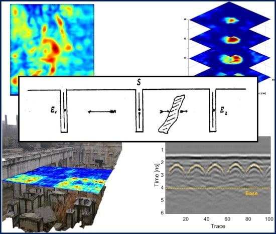
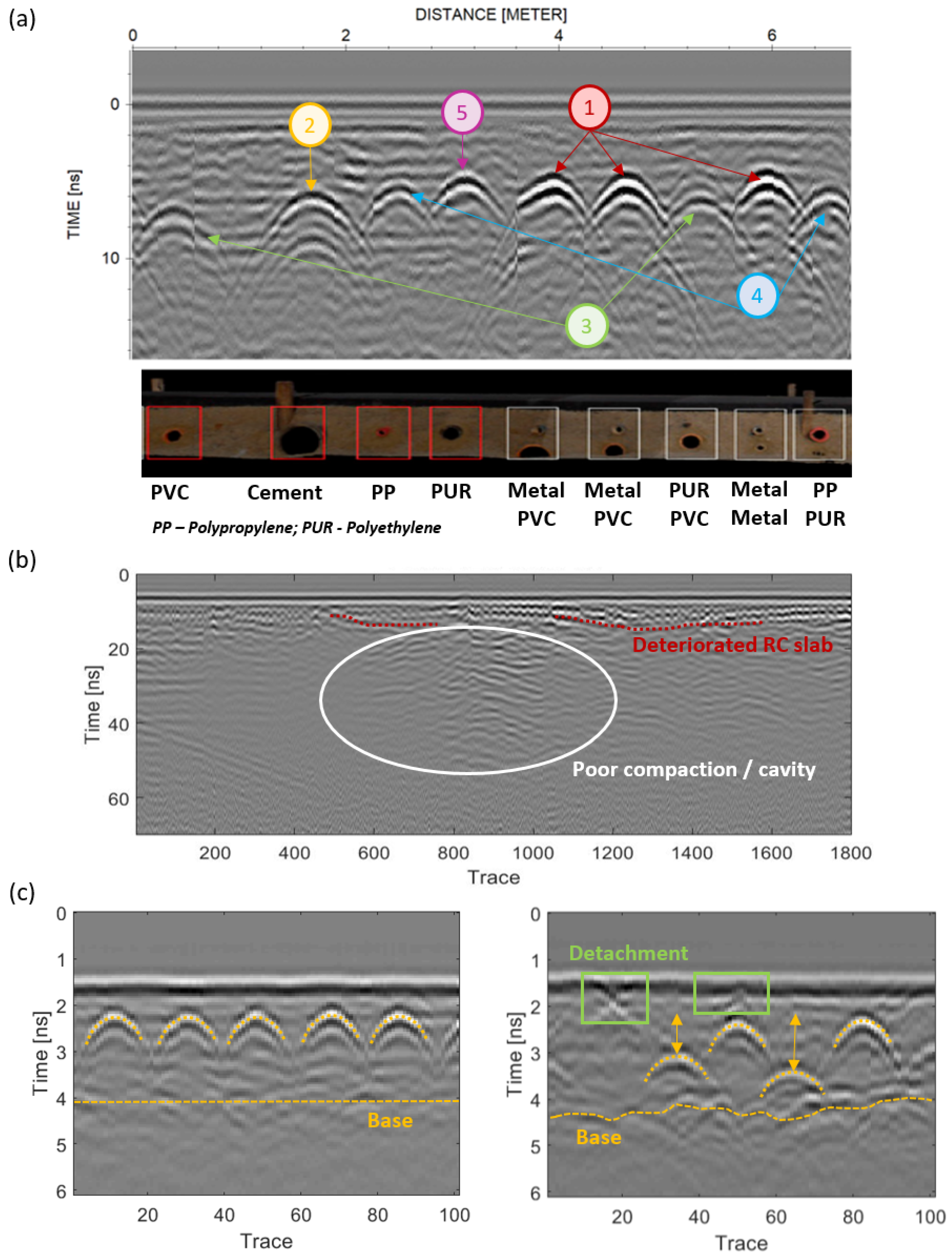
2. GPR Applications in Civil Engineering
3. GPR Applications in Archeology and Cultural Heritage
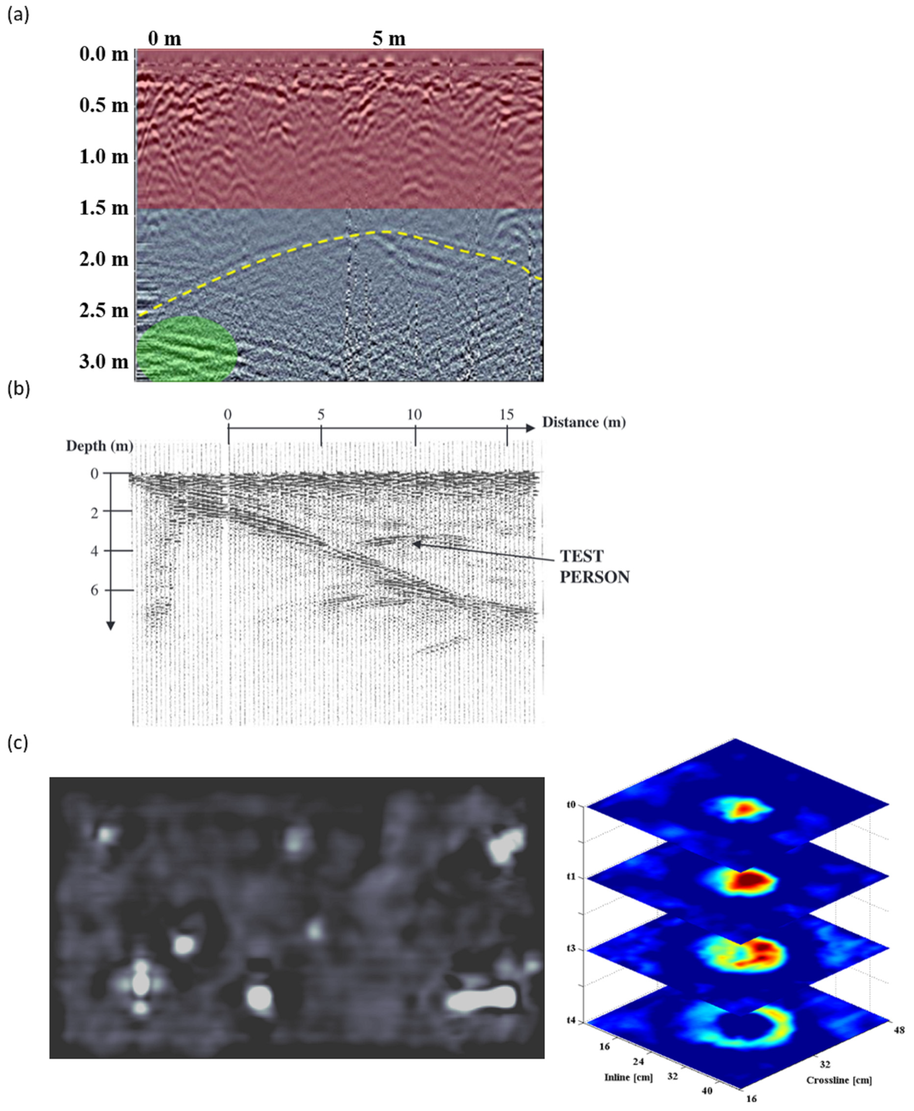
4. GPR Applications in Forensic and Security
5. GPR Applications in Environmental Investigations

6. GPR Applications in Geology

| Application | Title | Year | Ref. |
|---|---|---|---|
| Fractures/faults | The use of Ground-Penetrating Radar to distinguish between seismic and non-seismic hazards in hard rock mining | 2020 | [296] |
| Stratigraphic studies | Ground-Penetrating Radar and its use in sedimentology: principles, problems and progress. | 2004 | [297] |
| A review of Ground-Penetrating Radar studies related to peatland stratigraphy with a case study on the determination of peat thickness in a northern boreal fen in Quebec, Canada | 2013 | [298] | |
| Bathymetry | Water penetrating radar | 2021 | [299] |
| Sand bodies | Radar suitability in aeolian sand dunes—A global review | 2012 | [300] |
| Planetary exploration | Applications of Radar Systems in Planetary Sciences: An Overview | 2015 | [301] |

7. Conclusions and Further Perspectives
Author Contributions
Funding
Data Availability Statement
Conflicts of Interest
References
- Stern, W. Versuch einer elektrodynamischen dickenmessung von gletschereis. Gerlands Beitr. Geophys. 1929, 27, 292–333. [Google Scholar]
- Waite, A.; Schmidt, S. Gross Errors in Height Indication from Pulsed Radar Altimeters Operating over Thick Ice or Snow. Proc. IRE 1962, 50, 1515–1520. [Google Scholar] [CrossRef]
- Porcello, L.; Jordan, R.; Zelenka, J.; Adams, G.; Phillips, R.; Brown, W.; Ward, S.; Jackson, P. The Apollo lunar sounder radar system. Proc. IEEE 1974, 62, 769–783. [Google Scholar] [CrossRef]
- Sloan, S. A current look at geophysical detection of illicit tunnels. Geophysics 2015, 34, 154–158. [Google Scholar] [CrossRef]
- Ballard, R.F. Tunnel Detection. Geotechnical Laboratory U. S. Army Engineer Waterways Experiment Station. 1982. Available online: www.apps.dtic.mil/sti/citations/ADA121447 (accessed on 3 May 2022).
- Nilsson, B. Two Topics in Electromagnetic Radiation Field Prospecting. Ph.D. Thesis, University of Lulea, Lulea, Sweden, 1978. [Google Scholar]
- BBC News. Available online: http://news.bbc.co.uk/2/hi/uk_news/1019682.stm (accessed on 3 May 2022).
- BBC News. Available online: http://news.bbc.co.uk/1/hi/uk/7103836.stm (accessed on 3 May 2022).
- Travassos, X.L.; Avila, S.L.; Adriano, R.L.D.S.; Ida, N. A Review of Ground-Penetrating Radar Antenna Design and Optimization. J. Microw. Optoelectron. Electromagn. Appl. 2018, 17, 385–402. [Google Scholar] [CrossRef]
- Diamanti, N.; Redman, J.D.; Hogan, C.M.; Annan, A.P. Air-launched GPR depth of investigation. In Proceedings of the 18th International Conference on Ground-Penetrating Radar, Golden, CO, USA, 14–19 June 2020; pp. 228–231. [Google Scholar] [CrossRef]
- Diamanti, N.; Annan, A.P. Air-launched and ground-coupled GPR data. In Proceedings of the 2017 11th European Conference on Antennas and Propagation (EUCAP), Paris, France, 19–24 March 2017; pp. 1694–1698. [Google Scholar] [CrossRef]
- Van De Vijver, E.; De Pue, J.; Cornelis, W.; Van Meirvenne, M. Comparison of air-launched and ground-coupled configurations of SFCW GPR in time, frequency and wavelet domain. In Proceedings of the EGU General Assembly Conference Abstracts, Vienna, Austria, 12–17 April 2015; p. 10038. [Google Scholar]
- Benedetto, L.A.; Pajewski, L. Civil Engineering Applications of Ground-Penetrating Radar. In Transactions in Civil and Environmental Engineering; Springer International: New York, NY, USA, 2015. [Google Scholar]
- Dinh, K.; Gucunski, N.; Zayed, T. Automated visualization of concrete bridge deck condition from GPR data. NDT E Int. 2018, 102, 120–128. [Google Scholar] [CrossRef]
- Šarlah, N.; Podobnikar, T.; Ambrožič, T.; Mušič, B. Application of Kinematic GPR-TPS Model with High 3D Georeference Accuracy for Underground Utility Infrastructure Mapping: A Case Study from Urban Sites in Celje, Slovenia. Remote Sens. 2020, 12, 1228. [Google Scholar] [CrossRef]
- Ayala-Cabrera, D.; Herrera, M.; Izquierdo, J.; Pérez-García, R. Location of buried plastic pipes using multi-agent support based on GPR images. J. Appl. Geophys. 2011, 75, 679–686. [Google Scholar] [CrossRef]
- Rasol, M.; Pérez-Gracia, V.; Solla, M.; Pais, J.C.; Fernandes, F.M.; Santos, C. An experimental and numerical approach to combine Ground-Penetrating Radar and computational modeling for the identification of early cracking in cement concrete pavements. NDT E Int. 2020, 115, 102293. [Google Scholar] [CrossRef]
- Solla, M.; Fernández, N. GPR analysis to detect subsidence: A case study on a loaded reinforced concrete pavement. Int. J. Pavement Eng. 2022, 1–15. [Google Scholar] [CrossRef]
- Rasol, M.A.; Pérez-Gracia, V.; Fernandes, F.M.; Pais, J.C.; Solla, M.; Santos, C. NDT assessment of rigid pavement damages with Ground-Penetrating Radar: Laboratory and field tests. Int. J. Pavement Eng. 2020, 23, 900–915. [Google Scholar] [CrossRef]
- Fernandes, F.; Fernandes, A.; Pais, J. Assessment of the density and moisture content of asphalt mixtures of road pavements. Constr. Build. Mater. 2017, 154, 1216–1225. [Google Scholar] [CrossRef]
- Baltrušaitis, A.; Vaitkus, A.; Smirnovs, J. Asphalt Layer Density and Air Voids Content: GPR and Laboratory Testing Data Reliance. Balt. J. Road Bridg. Eng. 2020, 15, 93–110. [Google Scholar] [CrossRef]
- Alani, A.M.; Aboutalebi, M.; Kilic, G. Applications of Ground-Penetrating Radar (GPR) in bridge deck monitoring and assessment. J. Appl. Geophys. 2013, 97, 45–54. [Google Scholar] [CrossRef]
- Liu, H.; Deng, Z.; Han, F.; Xia, Y.; Liu, Q.H.; Sato, M. Time-frequency analysis of air-coupled GPR data for identification of delamination between pavement layers. Constr. Build. Mater. 2017, 154, 1207–1215. [Google Scholar] [CrossRef]
- Al-Qadi, I.L.; Xie, W.; Jones, D.L.; Roberts, R. Development of a time–frequency approach to quantify railroad ballast fouling condition using ultra-wide band Ground-Penetrating Radar data. Int. J. Pavement Eng. 2010, 11, 269–279. [Google Scholar] [CrossRef]
- Plati, C.; Loizos, A.; Papavasiliou, V. Inspection of railroad ballast using geophysical method. Int. J. Pavement Eng. 2010, 11, 309–317. [Google Scholar] [CrossRef]
- De Bold, R.; O’Connor, G.; Morrissey, J.; Forde, M. Benchmarking large scale GPR experiments on railway ballast. Constr. Build. Mater. 2015, 92, 31–42. [Google Scholar] [CrossRef]
- Abraham, O.; Dérobert, X. Non-destructive testing of fired tunnel walls: The Mont-Blanc Tunnel case study. NDT E Int. 2003, 36, 411–418. [Google Scholar] [CrossRef]
- Parkinson, G.; Ékes, C. Ground-Penetrating Radar Evaluation of Concrete Tunnel Linings. In Proceedings of the 12th International Conference Ground-Penetrating Radar (GPR), Birmingham, UK, 16–19 June 2008. [Google Scholar]
- Zhang, F.; Xie, X.; Huang, H.-W. Application of Ground-Penetrating Radar in grouting evaluation for shield tunnel construction. Tunn. Undergr. Space Technol. 2010, 25, 99–107. [Google Scholar] [CrossRef]
- Prego, F.J.; Solla, M.; Núñez-Nieto, X.; Arias, P. Assessing the Applicability of Ground-Penetrating Radar to Quality Control in Tunneling Construction. J. Constr. Eng. Manag. 2016, 142, 06015006. [Google Scholar] [CrossRef]
- Balaguer, C.; Montero, R.; Victores, J.G.; Martínez, S.; Jardón, A. Towards fully automated tunnel inspection: A survey and future trends. In Proceedings of the 31st International Symposium on Automation and Robotics in Construction and Mining (ISARC 2014), Sydney, Australia, 9–11 July 2014. [Google Scholar] [CrossRef]
- Xie, X.Y.; Chen, Y.F.; Zhou, B. Data processing of backfill grouting detected by GPR in shield tunnel and research on equipment of GPR antenna. In Proceedings of the 16th International Conference on Ground-Penetrating Radar (GPR), Hong Kong, China, 13–16 June 2016. [Google Scholar] [CrossRef]
- Zan, Y.W.; Su, G.F.; Li, Z.L. A Train-mounted GPR System for Fast and Efficient Monitoring of Tunnel Health Conditions. In Proceedings of the 16th International Conference on Ground-Penetrating Radar (GPR), Hong Kong, China, 13–16 June 2016. [Google Scholar] [CrossRef]
- Trela, C.; Wöstmann, J.; Kruschwitz, S. Contribution of radar measurements to the inspection and condition assessment of railway bridges—Case study at a historic masonry arch bridge in Oleśnica/Poland. WIT Trans. Built Environ. 2008, 97, 535–544. [Google Scholar] [CrossRef]
- Ukleja, J.; Bęben, D.; Anigacz, W. Determination of the railway retaining wall dimensions and its foundation in difficult terrain and utility. AGH J. Min. Geoengin. 2012, 36, 299–308. [Google Scholar]
- Solla, M.; Lorenzo, H.; Rial, F.I.; Novo, A. Ground-Penetrating Radar for the structural evaluation of masonry bridges: Results and interpretational tools. Constr. Build. Mater. 2012, 29, 458–465. [Google Scholar] [CrossRef]
- Conde, B.; Ramos, L.F.; Oliveira, D.V.; Riveiro, B.; Solla, M. Structural assessment of masonry arch bridges by combination of non-destructive testing techniques and three-dimensional numerical modelling: Application to Vilanova bridge. Eng. Struct. 2017, 148, 621–638. [Google Scholar] [CrossRef]
- Hugenschmidt, J.; Mastrangelo, R. GPR inspection of concrete bridges. Cem. Concr. Compos. 2006, 28, 384–392. [Google Scholar] [CrossRef]
- Hugenschmidt, J.; Kalogeropoulos, A. The inspection of retaining walls using GPR. J. Appl. Geophys. 2009, 67, 335–344. [Google Scholar] [CrossRef]
- Loperte, A.; Bavusi, M.; Cerverizzo, G.; Lapenna, V.; Soldovieri, F. Ground-Penetrating Radar in Dam Monitoring: The Test Case of Acerenza (Southern Italy). Int. J. Geophys. 2011, 2011, 654194. [Google Scholar] [CrossRef]
- Diamanti, N.; Annan, A.P.; Redman, J.D. Concrete Bridge Deck Deterioration Assessment Using Ground-Penetrating Radar (GPR). J. Environ. Eng. Geophys. 2017, 22, 121–132. [Google Scholar] [CrossRef]
- Rathod, H.; Debeck, S.; Gupta, R.; Chow, B. Applicability of GPR and a rebar detector to obtain rebar information of existing concrete structures. Case Stud. Constr. Mater. 2019, 11, e00240. [Google Scholar] [CrossRef]
- Pérez-Gracia, V.; García, F.G.; Abad, I.R. GPR evaluation of the damage found in the reinforced concrete base of a block of flats: A case study. NDT E Int. 2008, 41, 341–353. [Google Scholar] [CrossRef]
- Pérez-Gracia, V.; Caselles, O.; Clapes, J.; Santos-Assuncao, S. GPR building inspection: Examples of building structures assessed with Ground-Penetrating Radar. In Proceedings of the 9th International Workshop on Advanced Ground-Penetrating Radar (IWAGPR), Edinburg, UK, 28–30 June 2017; pp. 1–4. [Google Scholar] [CrossRef]
- Solla, M.; Gonçalves, L.; Gonçalves, G.; Francisco, C.; Puente, I.; Providência, P.; Gaspar, F.; Rodrigues, H. A Building Information Modeling Approach to Integrate Geomatic Data for the Documentation and Preservation of Cultural Heritage. Remote Sens. 2020, 12, 4028. [Google Scholar] [CrossRef]
- Gehrig, M.D.; Morris, D.V.; Bryant, J.T. Ground-Penetrating Radar for Concrete Evaluation Studies. In Proceedings of the Foundation Performance Association Meeting, London, UK, 24 March 2004. [Google Scholar]
- Capozzoli, L.; De Martino, G.; Polemio, M.; Rizzo, E. Geophysical Techniques for Monitoring Settlement Phenomena Occurring in Reinforced Concrete Buildings. Surv. Geophys. 2019, 41, 575–604. [Google Scholar] [CrossRef]
- Pérez-Gracia, V.; Gónzalez-Drigo, R.; Di Capua, D.; Pujades, L.G. Experimental analysis of the resolution in shallow GPR survey. In Proceedings of the SPIE Remote Sensing for Environmental Monitoring, GIS Applications, and Geology VII, Florence, Italy, 17–20 September 2007; SPIE: Bellingham, WA, USA, 2007; Volume 6749, p. 67492M. [Google Scholar] [CrossRef]
- Lopez, S.L.; Carracelas, M.S.; Vilariño, L.D.; González, J.A. Inspection of radiant heating floor applying non-destructive testing techniques: GPR and IRT. DYNA 2015, 82, 221–226. [Google Scholar] [CrossRef]
- Rucka, M.; Wojtczak, E.; Zielińska, M. Interpolation methods in GPR tomographic imaging of linear and volume anomalies for cultural heritage diagnostics. Measurement 2020, 154, 107494. [Google Scholar] [CrossRef]
- Cotič, P.; Jagličić, Z.; Bosiljkov, V.; Niederleithinger, E. GPR and IRT thermography for near-surface defect detection in building structures. In Proceedings of the XII Int Conference of the Slovenian Society for Non-Destructive Testing, Portorož, Slovenia, 4–6 September 2013. [Google Scholar]
- Çağlar Yalçıner, C.; Büyüksaraç, A.; Kurban, Y.C. Non-destructive damage analysis in Kariye (Chora) Museum as a cultural heritage building. J. Appl. Geophys. 2019, 171, 103874. [Google Scholar] [CrossRef]
- Negri, S.; Aiello, M. High-resolution GPR survey for masonry wall diagnostics. J. Build. Eng. 2020, 33, 101817. [Google Scholar] [CrossRef]
- Agliata, R.; Bogaard, T.A.; Greco, R.; Mollo, L.; Slob, E.; Steele-Dunne, S.C. Non-invasive estimation of moisture content in tuff bricks by GPR. Constr. Build. Mater. 2018, 160, 698–706. [Google Scholar] [CrossRef]
- Garrido, I.; Solla, M.; Lagüela, S.; Fernández, N. IRT and GPR Techniques for Moisture Detection and Characterisation in Buildings. Sensors 2020, 20, 6421. [Google Scholar] [CrossRef]
- Lai, W.W.; Ho, M.L.-Y.; Chang, R.K.; Sham, J.F.C.; Poon, C.S. Tracing and imaging minor water seepage of concealed PVC pipe in a reinforced concrete wall by high-frequency Ground-Penetrating Radar. Constr. Build. Mater. 2017, 151, 840–847. [Google Scholar] [CrossRef]
- Lualdi, M.; Lombardi, F. Utilities detection through the sum of orthogonal polarization in 3D georadar surveys. Near Surf. Geophys. 2010, 13, 73–82. [Google Scholar] [CrossRef]
- Taştan, E.; Koşaroğlu, K.; Bilim, F. Identifying of structural elements of buildings using Ground-Penetrating Radar (GPR): A case study of the Cumhuriyet University, Turkey. J. Sci. Technol. 2017, 7, 22–26. [Google Scholar] [CrossRef]
- Solla, M.; Lagüela, S.; Fernández, N.; Garrido, I. Assessing Rebar Corrosion through the Combination of Nondestructive GPR and IRT Methodologies. Remote Sens. 2019, 11, 1705. [Google Scholar] [CrossRef]
- Asadi, P.; Gindy, M.; Alvarez, M. A Machine Learning Based Approach for Automatic Rebar Detection and Quantification of Deterioration in Concrete Bridge Deck Ground-Penetrating Radar B-scan Images. KSCE J. Civ. Eng. 2019, 23, 2618–2627. [Google Scholar] [CrossRef]
- Kim, N.; Kim, S.; An, Y.-K.; Lee, J.-J. A novel 3D GPR image arrangement for deep learning-based underground object classification. Int. J. Pavement Eng. 2019, 22, 740–751. [Google Scholar] [CrossRef]
- Liu, H.; Lin, C.; Cui, J.; Fan, L.; Xie, X.; Spencer, B.F. Detection and localization of rebar in concrete by deep learning using Ground-Penetrating Radar. Autom. Constr. 2020, 118, 103279. [Google Scholar] [CrossRef]
- Tong, Z.; Gao, J.; Yuan, D. Advances of deep learning applications in Ground-Penetrating Radar: A survey. Constr. Build. Mater. 2020, 258, 120371. [Google Scholar] [CrossRef]
- Mertens, L.; Persico, R.; Matera, L.; Lambot, S. Automated Detection of Reflection Hyperbolas in Complex GPR Images With No A Priori Knowledge on the Medium. IEEE Trans. Geosci. Remote Sens. 2015, 54, 580–596. [Google Scholar] [CrossRef]
- Kim, N.; Kim, S.; An, Y.-K.; Lee, J.-J. Triplanar Imaging of 3-D GPR Data for Deep-Learning-Based Underground Object Detection. IEEE J. Sel. Top. Appl. Earth Obs. Remote Sens. 2019, 12, 4446–4456. [Google Scholar] [CrossRef]
- Feng, J.; Yang, L.; Hoxha, E.; Sanakov, D.; Sotnikov, S.; Xiao, J. GPR-based Model Reconstruction System for Underground Utilities Using GPRNet. In Proceedings of the 2021 IEEE International Conference on Robotics and Automation (ICRA), Xi’an, China, 30 May–5 June 2021; pp. 845–851. [Google Scholar] [CrossRef]
- Yamaguchi, T.; Mizutani, T.; Nagayama, T. Mapping Subsurface Utility Pipes by 3-D Convolutional Neural Network and Kirchhoff Migration Using GPR Images. IEEE Trans. Geosci. Remote Sens. 2020, 59, 6525–6536. [Google Scholar] [CrossRef]
- Gabryś, M.; Ortyl, Ł. Georeferencing of Multi-Channel GPR—Accuracy and Efficiency of Mapping of Underground Utility Networks. Remote Sens. 2020, 12, 2945. [Google Scholar] [CrossRef]
- Nichols, P.; McCallum, A.; Lucke, T. Using Ground-Penetrating Radar to locate and categorise tree roots under urban pavements. Urban For. Urban Green. 2017, 27, 9–14. [Google Scholar] [CrossRef]
- Prego, F.; Solla, M.; Puente, I.; Arias, P. Efficient GPR data acquisition to detect underground pipes. NDT E Int. 2017, 91, 22–31. [Google Scholar] [CrossRef]
- Rasol, M.; Pais, J.C.; Pérez-Gracia, V.; Solla, M.; Fernandes, F.M.; Fontul, S.; Ayala-Cabrera, D.; Schmidt, F.; Assadollahi, H. GPR monitoring for road transport infrastructure: A systematic review and machine learning insights. Constr. Build. Mater. 2022, 324, 126686. [Google Scholar] [CrossRef]
- Solla, M.; Pérez-Gracia, V.; Fontul, S. A Review of GPR Application on Transport Infrastructures: Troubleshooting and Best Practices. Remote Sens. 2021, 13, 672. [Google Scholar] [CrossRef]
- Klewe, T.; Strangfeld, C.; Kruschwitz, S. Review of moisture measurements in civil engineering with Ground-Penetrating Radar—Applied methods and signal features. Constr. Build. Mater. 2021, 278, 122250. [Google Scholar] [CrossRef]
- Tešić, K.; Baričević, A.; Serdar, M. Non-Destructive Corrosion Inspection of Reinforced Concrete Using Ground-Penetrating Radar: A Review. Materials 2021, 14, 975. [Google Scholar] [CrossRef]
- Dabous, S.A.; Feroz, S. Condition monitoring of bridges with non-contact testing technologies. Autom. Constr. 2020, 116, 103224. [Google Scholar] [CrossRef]
- Pajewski, L.; Fontul, S.; Solla, M. Chapter 10: Ground-Penetrating Radar for the evaluation and monitoring of transport infrastructures. In Innovation in Near-Surface Geophysics. Instrumentation, Application, and Data Processing Methods; Elsevier: Amsterdam, The Netherlands, 2019. [Google Scholar] [CrossRef]
- Lai, W.W.-L.; Dérobert, X.; Annan, P. A review of Ground-Penetrating Radar application in civil engineering: A 30-year journey from Locating and Testing to Imaging and Diagnosis. NDT E Int. 2018, 96, 58–78. [Google Scholar] [CrossRef]
- Bachiri, T.; Khamlichi, A.; Bezzazi, M. Bridge deck condition assessment by using GPR: A review. In Proceedings of the 1st International Conference on Non-Destructive Evaluation of Composite Structures (NDECS 2017), Tetouan, Morocco, 25 November 2017. [Google Scholar] [CrossRef]
- Rehman, S.K.U.; Ibrahim, Z.; Memon, S.A.; Jameel, M. Nondestructive test methods for concrete bridges: A review. Constr. Build. Mater. 2016, 107, 58–86. [Google Scholar] [CrossRef]
- Evans, R.D.; Frost, M.; Stonecliffe-Jones, M.; Dixon, N. A review of pavement assessment using Ground-Penetrating Radar (GPR). In Proceedings of the 12th International Conference Ground-Penetrating Radar, Birmingham, UK, 16–19 June 2008. [Google Scholar]
- McCann, D.; Forde, M. Review of NDT methods in the assessment of concrete and masonry structures. NDT E Int. 2001, 34, 71–84. [Google Scholar] [CrossRef]
- Martinho, E.; Dionísio, A. Main geophysical techniques used for non-destructive evaluation in cultural built heritage: A review. J. Geophys. Eng. 2014, 11, 053001. [Google Scholar] [CrossRef]
- Viberg, A.; Trinks, I.; Lidén, K. A review of the use of geophysical archaeological prospection in Sweden. Archaeol. Prospect. 2011, 18, 43–56. [Google Scholar] [CrossRef]
- Conyers, L.B. Ground-Penetrating Radar for Archaeology. Geophysical Methods for Archaeology; Altamira Press: Lanham, MD, USA, 2004; ISBN 9780759107724. [Google Scholar]
- Goodman, D.; Piro, S. GPR Remote Sensing in Archaeology, Geotechnologies and the Environment; Springer: Berlin, Germany, 2013; Volume 9. [Google Scholar]
- Trinks, I.; Johansson, B.; Gustafsson, J.; Emilsson, J.; Friborg, J.; Gustafsson, C.; Nissen, J.; Hinterleitner, A. Efficient, large-scale archaeological prospection using a true three-dimensional Ground-Penetrating Radar Array system. Archaeol. Prospect. 2010, 17, 175–186. [Google Scholar] [CrossRef]
- Bornik, A.; Wallner, M.; Hinterleitner, A.; Verhoeven, G.J.J.; Neubauer, W. Integrated volume visualisation of archaeological Ground-Penetrating Radar data. In Proceedings of the 16th Eurographics Work on Graphics and Cultural Heritage, Vienna, Austria, 12–15 November 2018. [Google Scholar]
- Löcker, K.; Baldwin, E.; Neubauer, W.; Gaffney, W.; Gaffney, C.; Hinterleitner, A.; Garwood, P.J.; Trinks, I.; Wallner, M. The Stonehenge hidden landscape project—Data acquisition, processing, interpretation. In Proceedings of the 10th International Conference Archaeological Prospection, Vienna, Austria, 20 May–2 June 2013. [Google Scholar]
- Lazãr, C.; Ene, D.; Parnic, V.; Popovici, D.N.; Florea, M. Ground-Penetrating Radar prospections in Romania. Mǎriuta-la movilǎ necropolis, a case study. Mediterr. Archaeol. Archaeom. 2011, 11, 79–89. [Google Scholar]
- Leucci, G.; De Giorgi, L.; Di Giacomo, G.; Ditaranto, I.; Miccoli, I.; Scardozzi, G. 3D GPR survey for the archaeological characterization of the ancient Messapian necropolis in Lecce, South Italy. J. Archaeol. Sci. Rep. 2016, 7, 290–302. [Google Scholar] [CrossRef]
- Bornik, A.; Neubauer, W. 3D Visualization Techniques for Analysis and Archaeological Interpretation of GPR Data. Remote Sens. 2022, 14, 1709. [Google Scholar] [CrossRef]
- Pérez-Gracia, V.; Caselles, J.O.; Clapés, J.; Martinez, G.; Osorio, R. Non-destructive analysis in cultural heritage buildings: Evaluating the Mallorca cathedral supporting structures. NDT E Int. 2013, 59, 40–47. [Google Scholar] [CrossRef]
- Catapano, I.; Ludeno, G.; Soldovieri, F.; Tosti, F.; Padeletti, G. Structural assessment via Ground-Penetrating Radar at the Consoli Palace of Gubbio (Italy). Remote Sens. 2018, 10, 45. [Google Scholar] [CrossRef]
- Fontul, S.; Solla, M.; Cruz, H.; Machado, J.S.; Pajewski, L. Ground-Penetrating Radar investigations in the Noble Hall of the São Carlos theater in Lisbon, Portugal. Surv. Geophys. 2018, 39, 1125–1147. [Google Scholar] [CrossRef]
- Novo, A.; Lorenzo, H.; Rial, F.I.; Solla, M. Three-dimensional Ground-Penetrating Radar strategies over an indoor archaeological site: Convent of Santo Domingo (Lugo, Spain). Archaeol. Prospect. 2010, 17, 213–222. [Google Scholar] [CrossRef]
- Leucci, G.; De Giorgi, L.; Ditaranto, I.; Miccoli, I.; Scardozzi, G. Ground-Penetrating Radar Prospections in Lecce Cathedral: New Data about the Crypt and the Structures under the Church. Remote Sens. 2021, 13, 1692. [Google Scholar] [CrossRef]
- Masini, N.; Nuzzo, L.; Rizzo, E. GPR investigations for the study and the restoration of the Rose Window of Troia Cathedral (Southern Italy). Near. Surf. Geophys. 2007, 5, 287–300. [Google Scholar] [CrossRef]
- Santos-Assunçao, S.; Dimitriadis, K.; Konstantakis, Y.; Perez-Gracia, V.; Anagnostopoulou, E.; Gonzalez-Drigo, R. Ground-Penetrating Radar evaluation of the ancient Mycenaean monument Tholos Acharnon tomb. Near. Surface Geophys. 2016, 14, 197–205. [Google Scholar] [CrossRef]
- Kadioglu, S. Transparent 2d/3d half bird’s-eye view of Ground-Penetrating Radar data set in archaeology and cultural heritage. In Imaging and Radioanalytical Techniques in Interdisciplinary Research—Fundamentals and Cutting Edge Applications; IntechOpen: London, UK, 2013. [Google Scholar]
- Dimitriadis, K. GPR in the Preservation of Cultural Heritage. In COST Action TU1208, Proceedings of the TU1208 Third General Meeting, London, UK, 4–6 March 2015; Aracne, Ariccia: Rome, Italy, 2015; ISBN 978-88-548-8486-1. [Google Scholar]
- Solla, M.; Riveiro, B.; Lorenzo, H.; Armesto, J. Ancient stone bridge surveying by Ground-Penetrating Radar and numerical modeling methods. J. Bridge Eng. 2014, 19, 110–119. [Google Scholar] [CrossRef]
- Alani, A.M.; Tosti, F.; Bianchini Ciampoli, L.; Gagliardi, V.; Benedetto, A. An integrated investigative approach in health monitoring of masonry arch bridges using GPR and InSAR technologies. NDT E Int. 2020, 115, 102288. [Google Scholar] [CrossRef]
- Lombardi, F.; Lualdi, M.; Garavaglia, E. Masonry texture reconstruction for building seismic assessment: Practical evaluation and potentials of Ground-Penetrating Radar methodology. Constr. Build. Mater. 2021, 299, 124189. [Google Scholar] [CrossRef]
- Danese, M.; Sileo, M.; Masini, N. Geophysical Methods and Spatial Information for the Analysis of Decaying Frescoes. Surv. Geophys. 2018, 39, 1149–1166. [Google Scholar] [CrossRef]
- Calia, A.; Lettieri, M.; Leucci, G.; Matera, L.; Persico, R.; Sileo, M. The mosaic of the crypt of St. Nicholas in Bari (Italy): Integrated GPR and laboratory diagnostic study. J. Archaeol. Sci. 2013, 40, 4162–4169. [Google Scholar] [CrossRef]
- Caldeira, B.; Oliveira, R.J.; Teixidó, T.; Borges, J.F.; Henriques, R.; Carneiro, A.; Peña, J.A. Studying the Construction of Floor Mosaics in the Roman Villa of Pisões (Portugal) Using Noninvasive Methods: High-Resolution 3D GPR and Photogrammetry. Remote Sens. 2019, 11, 1882. [Google Scholar] [CrossRef]
- Carrozzo, M.T.; Leucci, G.; Negri, S.; Pierri, C.; Varola, A. Ground-Penetrating Radar: Preliminary results to locate vertebrate fossils. In Proceedings of the SAGEEP 2003, Environ and Engineering Geophysical Society, San Antonio, TX, USA, 6–10 April 2003; pp. 1017–1103. [Google Scholar]
- Tinelli, C.; Ribolini, A.; Bianucci, G.; Bini, M.; Landini, W. Ground-Penetrating Radar and palaeontology: The detection of sirenian fossil bones under a sunflower field in Tuscany (Italy). C. R. Palevol 2012, 11, 445–454. [Google Scholar] [CrossRef]
- Main, D.J.; Hammon, W.S. The application of Ground-Penetrating Radar as a mapping technique at vertebrate fossil excavations in the Cretaceous of Texas. Cretaceous Res. 2003, 24, 335–345. [Google Scholar] [CrossRef]
- Manataki, M.; Vafidis, A.; Sarris, A. GPR Data Interpretation Approaches in Archaeological Prospection. Appl. Sci. 2021, 11, 7531. [Google Scholar] [CrossRef]
- Küçükdemirci, M.; Sarris, A. Deep learning based automated analysis of archaeo-geophysical images. Archaeol. Prospect. 2020, 27, 107–118. [Google Scholar] [CrossRef]
- Puente, I.; Solla, M.; Lagüela, S.; Sanjurjo-Pinto, J. Reconstructing the Roman Site “Aquis Querquennis” (Bande, Spain) from GPR, T-LiDAR and IRT Data Fusion. Remote Sens. 2018, 10, 379. [Google Scholar] [CrossRef]
- Núñez-Nieto, X.; Solla, M.; Novo, A.; Lorenzo, H. Three-dimensional Ground-Penetrating Radar methodologies for the characterization and volumetric reconstruction of underground tunneling. Constr. Build. Mater. 2014, 71, 551–560. [Google Scholar] [CrossRef]
- Adamopoulos, E.; Rinaudo, F. Close-Range Sensing and Data Fusion for Built Heritage Inspection and Monitoring—A Review. Remote Sens. 2021, 13, 3936. [Google Scholar] [CrossRef]
- Nuzzo, L.; Quarta, T. GPR prospecting of cylindrical structures in cultural heritage applications: A review of geometric issues. Near Surf. Geophys. 2012, 10, 17–34. [Google Scholar] [CrossRef]
- Leucci, G. Nondestructive testing technologies for Cultural Heritage: Overview. In Nondestructive Testing for Archaeology and Cultural Heritage. A Practical Guide and New Perspectives; Springer: Cham, Switzerland, 2019. [Google Scholar]
- Trinks, I.; Hinterleitner, A.; Neubauer, W.; Nau, E.; Löcker, K.; Wallner, M.; Gabler, M.; Filzwieser, R.; Wilding, J.; Schiel, H.; et al. Large-area high-resolution Ground-Penetrating Radar measurements for archaeological prospection. Archaeol. Prospect. 2018, 25, 171–195. [Google Scholar] [CrossRef]
- Cuenca-García, C.; Risbøl, O.; Bates, C.; Stamnes, A.; Skoglund, F.; Ødegård, Ø.; Viberg, A.; Koivisto, S.; Fuglsang, M.; Gabler, M.; et al. Sensing Archaeology in the North: The Use of Non-Destructive Geophysical and Remote Sensing Methods in Archaeology in Scandinavian and North Atlantic Territories. Remote Sens. 2020, 12, 3102. [Google Scholar] [CrossRef]
- Pajewski, L.; Solla, M.; Küçükdemirci, M. Ground-Penetrating Radar for Archaeology and Cultural-Heritage diagnostics: Activities Carried Out in COST Action TU1208. In Nondestructive Techniques for the Assessment and Preservation of Historic Structures; Gonçalves, L.M.S., Rodrigues, H., Gaspar, F., Eds.; CRC Press: Boca Raton, FL, USA, 2018. [Google Scholar]
- Pérez-Gracia, V.; Fontul, S.; Santos-Assunçao, S.; Marecos, V. Geophysics: Fundamentals and Applications in Structures and Infrastructures. In NDT for the Evaluation of Structures and Infrastructure; Riveiro, B., Solla, M., Eds.; CRC Press/Balkema: Leiden, The Netherlands, 2016. [Google Scholar] [CrossRef]
- Daniels, D.J. A review of GPR for landmine detection. Sens. Imaging 2006, 7, 90–123. [Google Scholar] [CrossRef]
- Barone, P.M.; Di Maggio, R.M. Forensic geophysics: Ground-Penetrating Radar (GPR) techniques and missing persons investigations. Forensic Sci. Res. 2019, 4, 337–340. [Google Scholar] [CrossRef] [PubMed]
- Elis, V.R.; Almeida, E.R.; Porsani, J.L.; Stangari, M.C. Ground-Penetrating Radar, resistivity, and induced polarization applied in forensic research in tropical soils. In Proceedings of the 18th International Conference on Ground-Penetrating Radar, Golden, Colorado, 14–19 June 2020. [Google Scholar] [CrossRef]
- Barone, P.; Ferrara, C.; Pettinelli, E.; Annan, A.; Fazzari, A.; Redman, D. Forensic Geophysics: How GPR Could Help Police Investigations. In Proceedings of the Near Surface Geoscience 2012—18th European Meeting of Environmental and Engineering Geophysics, Paris, France, 3–5 September 2012; European Association of Geoscientists & Engineers: Houten, The Netherlands, 2012. [Google Scholar] [CrossRef]
- Niessen, J.; Kliem, E.; Pöhlking, E.; Nick, K.P. The use of Ground-Penetrating Radar to search for persons buried by avalanches. In Proceedings of the Fifth International Conferention on Ground-Penetrating Radar, Kitchener, ON, Canada, 12–16 June 1994. [Google Scholar]
- Novo, A.; Lorenzo, H.; Rial, F.I.; Solla, M. 3D GPR in forensics: Finding a clandestine grave in a mountainous environment. Forensic Sci. Int. 2011, 204, 134–138. [Google Scholar] [CrossRef] [PubMed]
- Sato, M. Introduction of the advanced ALIS: Advanced landmine Imaging System. In Detection and Sensing of Mines, Explosive Objects, and Obscured Targets XXIII; SPIE: Cergy-Pontoise, France, 2018. [Google Scholar]
- Sato, M. Disaster Monitoring by SAR, Gb-SAR and GPR. In Proceedings of the IGARSS 2019—2019 IEEE International Geoscience and Remote Sensing Symposium, Yokohama, Japan, 28 July–2 August 2019; pp. 4752–4755. [Google Scholar] [CrossRef]
- Núñez-Nieto, X.; Solla, M.; Lorenzo, H. Applications of GPR for Humanitarian Assistance and Security. In Civil Engineering Applications of Ground-Penetrating Radar; Benedetto, A., Pajewski, L., Eds.; Springer Transactions in Civil and Environ Engineering; Springer: Cham, Switzerland, 2015. [Google Scholar] [CrossRef]
- Ferrara, V. Technical survey about available technologies for detecting buried people under rubble or avalanches. WIT Trans. Built Environ. 2015, 150, 91–101. [Google Scholar] [CrossRef]
- Cist, D.B. Non-destructive evaluation after destruction: Using Ground-Penetrating Radar for search and rescue. In Proceedings of the 7th International Symposium on Nondestructive Testing in Civil Engineering, Nantes, France, 30 June–3 July 2009. [Google Scholar]
- Sovlukov, A.S.; Khablov, D.V. The capabilities of microwave methods for alive people detection through obstacles by breathing and heartbeat. Autom. Remote Control 2014, 75, 2060–2076. [Google Scholar] [CrossRef]
- Van, N.T.P.; Tang, L.; Demir, V.; Hasan, S.F.; Minh, N.D.; Mukhopadhyay, S. Review-Microwave Radar Sensing Systems for Search and Rescue Purposes. Sensors 2019, 19, 2879. [Google Scholar] [CrossRef]
- Instanes, A.; Lønne, I.; Sandaker, K. Location of avalanche victims with Ground-Penetrating Radar. Cold Reg. Sci. Technol. 2004, 38, 55–61. [Google Scholar] [CrossRef]
- Olhoeft, G.R.; Modroo, J.J. Locating and identifying avalanche victims with GPR. Lead. Edge 2006, 25, 306–308. [Google Scholar] [CrossRef]
- Diamanti, N.; Annan, A.P.; Giannakis, I. Predicting GPR performance for buried victim search & rescue. In Proceedings of the 16th International Conference on Ground-Penetrating Radar (GPR), Hong Kong, China, 13–16 June 2016. [Google Scholar]
- Chen, J.; Li, S.; Liu, D.; Li, X. AiRobSim: Simulating a Multisensor Aerial Robot for Urban Search and Rescue Operation and Training. Sensors 2020, 20, 5223. [Google Scholar] [CrossRef]
- Garcia-Fernandez, M.; Alvarez-Lopez, Y.; Las Heras, F. Autonomous Airborne 3D SAR Imaging System for Subsurface Sensing: UWB-GPR on Board a UAV for Landmine and IED Detection. Remote Sens. 2019, 11, 2357. [Google Scholar] [CrossRef]
- Grazzini, G.; Pieraccini, M.; Parrini, F.; Spinetti, A.; Macaluso, G.; Dei, D.; Atzeni, C. An ultra-wideband high-dynamic range GPR for detecting buried people after collapse of buildings. In Proceedings of the XIII International Conference on Ground-Penetrating Radar, Lecce, Italy, 21–25 June 2010; pp. 1–6. [Google Scholar] [CrossRef]
- Ivashchuk, V.E.; Prokhorenko, V.P.; Pitertsev, A.A.; Yanovsky, F.J. Through-the-wall moving target surveillance using GPR. In Proceedings of the 2013 European Microwave Conference, Nuremberg, Germany, 6–10 October 2013; pp. 1787–1790. [Google Scholar]
- Li, J.; Liu, L.; Zeng, Z.; Liu, F. Advanced Signal Processing for Vital Sign Extraction With Applications in UWB Radar Detection of Trapped Victims in Complex Environments. IEEE J. Sel. Top. Appl. Earth Obs. Remote Sens. 2014, 7, 783–791. [Google Scholar] [CrossRef]
- Yan, K.; Wu, S.; Fang, G. Detection of Quasi-Static Trapped Human Being Using Mono-Static UWB Life-Detection Radar. Appl. Sci. 2021, 11, 3129. [Google Scholar] [CrossRef]
- Humanitarian Demining, Geneva International Centre for, “Guidebook on Detection Technologies and Systems for Humanitarian Demining”. Global CWD Repository. 2006. Available online: https://commons.lib.jmu.edu/cisr-globalcwd/1301 (accessed on 3 May 2022).
- Capineri, L.; Ivashov, S.; Bechtel, T.; Zhuravlev, A.; Falorni, P.; Windsor, C.; Sheyko, A. Comparison of GPR sensor types for landmine detection and classification. In Proceedings of the 12th International Conference Ground-Penetrating Radar, Birmingham, UK, 16–19 June 2008; Volume 55. No. 2008. [Google Scholar]
- Van Verre, W.; Podd, F.J.; Tan, Y.M.; Gao, X.; Peyton, A.J. A Comparison of Solid and Loaded Bowtie Antennas in GPR for the Detection of Buried Landmines. In Proceedings of the 2018 17th International Conference Ground-Penetrating Radar (GPR), Rapperswil, Switzerland, 18–21 June 2018; pp. 1–6. [Google Scholar] [CrossRef]
- Bestagini, P.; Lombardi, F.; Lualdi, M.; Picetti, F.; Tubaro, S. Landmine Detection Using Autoencoders on Multipolarization GPR Volumetric Data. IEEE Trans. Geosci. Remote Sens. 2020, 59, 182–195. [Google Scholar] [CrossRef]
- Lombardi, F.; Griffiths, H.D.; Lualdi, M.; Balleri, A. Characterization of the Internal Structure of Landmines Using Ground-Penetrating Radar. IEEE Geosci. Remote Sens. Lett. 2020, 18, 266–270. [Google Scholar] [CrossRef]
- Núñez-Nieto, X.; Solla, M.; Gómez-Pérez, P.; Lorenzo, H. GPR Signal Characterization for Automated Landmine and UXO Detection Based on Machine Learning Techniques. Remote Sens. 2014, 6, 9729–9748. [Google Scholar] [CrossRef]
- Lombardi, F.; Lualdi, M.; Picetti, F.; Bestagini, P. Identification and Recognition of Landmine Internal Structure Scattering Contribution from GPR Data. In Proceedings of the 25th European Meeting of Environmental and Engineering Geophysics, Hague, The Netherlands, 8–12 September 2019. [Google Scholar]
- Kumlu, D.; Erer, I. Clutter removal techniques in Ground-Penetrating Radar for landmine detection: A Survey. In Operations Research for Military Organizations; IGI Global: Hershey, PA, USA, 2019; pp. 375–399. [Google Scholar] [CrossRef]
- Hibbard, M.W.; Etebari, A. NIITEK-NVESD AMDS program and interim field-ready system. In Proceedings of the SPIE Detection and Sensing of Mines, Explosive Objects, and Obscured Targets XV, Orlando, FL, USA, 5–9 April 2010; SPIE: Bellingham, WA, USA, 2010; Volume 7664, p. 766413. [Google Scholar] [CrossRef]
- Rubio-Melendi, D.; Gonzalez-Quirós, A.; Roberts, D.; García, M.D.C.G.; Domínguez, A.C.; Pringle, J.K.; Fernández-Álvarez, J.-P. GPR and ERT detection and characterization of a mass burial, Spanish Civil War, Northern Spain. Forensic Sci. Int. 2018, 287, e1–e9. [Google Scholar] [CrossRef]
- Hansen, J.D.; Pringle, J.K.; Goodwin, J. GPR and bulk ground resistivity surveys in graveyards: Locating unmarked burials in contrasting soil types. Forensic Sci. Int. 2014, 237, e14–e29. [Google Scholar] [CrossRef]
- Fiedler, S.; Illich, B.; Berger, J.; Graw, M. The effectiveness of Ground-Penetrating Radar surveys in the location of unmarked burial sites in modern cemeteries. J. Appl. Geophys. 2009, 68, 380–385. [Google Scholar] [CrossRef]
- Kelly, T.; Angel, M.; O’Connor, D.; Huff, C.; Morris, L.; Wach, G. A novel approach to 3D modelling Ground-Penetrating Radar (GPR) data—A case study of a cemetery and applications for criminal investigation. Forensic Sci. Int. 2021, 325, 110882. [Google Scholar] [CrossRef]
- Berezowski, V.; Mallett, X.; Ellis, J.; Moffat, I. Using Ground-Penetrating Radar and Resistivity Methods to Locate Unmarked Graves: A Review. Remote Sens. 2021, 13, 2880. [Google Scholar] [CrossRef]
- Giovanneschi, F.; Mishra, K.V.; Gonzalez-Huici, M.A.; Eldar, Y.C.; Ender, J.H.G. Dictionary Learning for Adaptive GPR Landmine Classification. IEEE Trans. Geosci. Remote Sens. 2019, 57, 10036–10055. [Google Scholar] [CrossRef]
- Barkataki, N.; Tiru, B.; Sarma, U. A CNN model for predicting size of buried objects from GPR B-Scans. J. Appl. Geophys. 2022, 200, 104620. [Google Scholar] [CrossRef]
- Moalla, M.; Frigui, H.; Karem, A.; Bouzid, A. Application of Convolutional and Recurrent Neural Networks for Buried Threat Detection Using Ground-Penetrating Radar Data. IEEE Trans. Geosci. Remote Sens. 2020, 58, 7022–7034. [Google Scholar] [CrossRef]
- Temlioglu, E.; Erer, I. A Novel Convolutional Autoencoder-Based Clutter Removal Method for Buried Threat Detection in Ground-Penetrating Radar. IEEE Trans. Geosci. Remote Sens. 2021, 60, 1–13. [Google Scholar] [CrossRef]
- Bralich, J.; Reichman, D.; Collins, L.M.; Malof, J.M. Improving convolutional neural networks for buried target detection in Ground-Penetrating Radar using transfer learning via pretraining. In Proceedings of the SPIE Detection and Sensing of Mines, Explosive Objects, and Obscured Targets XXII, Anaheim, CA, USA, 9–13 April 2017; SPIE: Bellingham, WA, USA, 2017; Volume 10182, pp. 198–208. [Google Scholar] [CrossRef]
- Hu, D.; Chen, J.; Li, S. Reconstructing unseen spaces in collapsed structures for search and rescue via deep learning based radargram inversion. Autom. Constr. 2022, 140, 104380. [Google Scholar] [CrossRef]
- Wood, A.; Wood, R.; Charnley, M. Through-the-wall radar detection using machine learning. Results Appl. Math. 2020, 7, 100106. [Google Scholar] [CrossRef]
- Brito-Da-Costa, A.M.; Martins, D.; Rodrigues, D.; Fernandes, L.; Moura, R.; Madureira-Carvalho, A. Ground-Penetrating Radar for Buried Explosive Devices Detection: A Case Studies Review. Aust. J. Forensic Sci. 2021, 1–20. [Google Scholar] [CrossRef]
- Pochanin, G.; Capineri, L.; Bechtel, T.; Ruban, V.; Falorni, P.; Crawford, F.; Ogurtsova, T.; Bossi, L. Radar Systems for Landmine Detection: Invited Paper. In Proceedings of the 2020 IEEE Ukrainian Microwave Week (UkrMW), Kharkiv, Ukraine, 21–25 September 2020; pp. 1118–1122. [Google Scholar] [CrossRef]
- Tellez, O.L.L.; Scheers, B. Ground-Penetrating Radar for Close-in Mine Detection. In Mine Action, The Research Experience of the Royal Military Academy of Belgium; IntechOpen: London, UK, 2017. [Google Scholar] [CrossRef]
- Crocco, L.; Ferrara, V. A review on Ground-Penetrating Radar technology for the detection of buried or trapped victims. In Proceedings of the 2014 International Conference Collaboration Technologies and Systems (CTS), Minneapolis, MN, USA, 19–23 May 2014; pp. 535–540. [Google Scholar]
- Sujatmiko, W.; Prastio, R.P.; Danudirdjo, D.; Suksmono, A.B. A Review of Radars to Detect Survivors Buried Under Earthquake Rubble. In Proceedings of the 2017 5th International Conference Instrumentation, Communications, Information Technology, and Biomedical Engineering (ICICI-BME), Bandung, Indonesia, 6–7 November 2017; pp. 309–313. [Google Scholar]
- Schultz, J.J. The Application of Ground-Penetrating Radar for Forensic Grave Detection. A Companion to Forensic Anthropology; Wiley: Hoboken, NJ, USA, 2012; pp. 85–100. [Google Scholar] [CrossRef]
- Leucci, G. Forensic Geosciences and Geophysics: Overview. Advances in Geophysical Methods Applied to Forensic Investigations; Springer: Cham, Switzerland, 2020; pp. 11–48. [Google Scholar] [CrossRef]
- Drahor, M.G.; Berge, M.A.; Öztürk, C. Integrated geophysical surveys for the subsurface mapping of buried structures under and surrounding of the Agios Voukolos Church in İzmir, Turkey. J. Archaeol. Sci. 2011, 38, 2231–2242. [Google Scholar] [CrossRef]
- Fritzsche, M.; Löhlein, O. Sensor Fusion for the Detection of Landmines. Subsurf. Sens. Technol. Appl. 2000, 1, 247–267. [Google Scholar] [CrossRef]
- Arosio, D. A microseismic approach to locate survivors trapped under rubble. Near Surf. Geophys. 2010, 8, 623–633. [Google Scholar] [CrossRef]
- Peters, L.P.; Daniels, J.J.; Young, J.D. Ground-Penetrating Radar as a subsurface environmental sensing tool. Proc. IEEE 1994, 82, 1802–1822. [Google Scholar] [CrossRef]
- Vereecken, H.; Binley, A.; Cassiani, G.; Revil, A.; Titov, K. (Eds.) Applied Hydrogeophysics; NATO Science Series; Springer: Dordrecht, The Netherlands, 2006; Volume 71. [Google Scholar] [CrossRef]
- Hubbard, S.; Chen, J.; Williams, K.; Rubin, Y.; Peterson, J. Environmental and agricultural applications of GPR. In Proceedings of the 3rd International Work on Advanced Ground-Penetrating Radar—IWAGPR 2005, Delft, The Netherlands, 2–3 May 2005. [Google Scholar]
- Alcalá, F.J.; Paz, M.C.; Martínez-Pagán, P.; Santos, F.M. Integrated Geophysical Methods for Shallow Aquifers Characterization and Modelling. Appl. Sci. 2022, 12, 2271. [Google Scholar] [CrossRef]
- Irving, J.; Xu, Z.; Lindsay, K.M.; Bradford, J.; Zhu, P.; Holliger, K. Determination of the correlation structure of an alluvial aquifer from multi-frequency 3D GPR reflection measurements. AGU Fall Meet. Abstr. 2019, 2019, H43F-2040. [Google Scholar]
- Kowalsky, M.B.; Finsterle, S.; Peterson, J.; Hubbard, S.; Rubin, Y.; Majer, E.; Ward, A.; Gee, G. Estimation of field-scale soil hydraulic and dielectric parameters through joint inversion of GPR and hydrological data. Water Resour. Res. 2005, 41, W11425. [Google Scholar] [CrossRef]
- Bowling, J.C.; Rodriguez, A.B.; Harry, D.L.; Zheng, C. Delineating Alluvial Aquifer Heterogeneity Using Resistivity and GPR Data. Ground Water 2005, 43, 890–903. [Google Scholar] [CrossRef]
- Montgomery, L.; Miège, C.; Miller, J.; Scambos, T.A.; Wallin, B.; Miller, O.; Solomon, D.K.; Forster, R.; Koenig, L. Hydrologic Properties of a Highly Permeable Firn Aquifer in the Wilkins Ice Shelf, Antarctica. Geophys. Res. Lett. 2020, 47, e2020GL089552. [Google Scholar] [CrossRef]
- Chen, J.; Hubbard, S.; Rubin, Y. Estimating the hydraulic conductivity at the south oyster site from geophysical tomographic data using Bayesian Techniques based on the normal linear regression model. Water Resour. Res. 2001, 37, 1603–1613. [Google Scholar] [CrossRef]
- Lunt, I.; Hubbard, S.; Rubin, Y. Soil moisture content estimation using Ground-Penetrating Radar reflection data. J. Hydrol. 2005, 307, 254–269. [Google Scholar] [CrossRef]
- Turesson, A. Water content and porosity estimated from Ground-Penetrating Radar and resistivity. J. App. Geophys. 2016, 58, 99–111. [Google Scholar] [CrossRef]
- Klotzsche, A.; Jonard, F.; Looms, M.; van der Kruk, J.; Huisman, J. Measuring Soil Water Content with Ground-Penetrating Radar: A Decade of Progress. Vadose Zone J. 2018, 17, 180052–180059. [Google Scholar] [CrossRef]
- Grote, K.; Leverett, K. Comparison of pedotransfer functions for high-resolution mapping of hydraulic conductivity in agricultural soils using GPR. AGU Fall Meet. Abstr. 2019, 2019, NS31A-0766. [Google Scholar]
- Steelman, C.M.; Endres, A.L. Comparison of Petrophysical Relationships for Soil Moisture Estimation using GPR Ground Waves. Vadose Zone J. 2011, 10, 270–285. [Google Scholar] [CrossRef]
- Shokri, M.; Gao, Y.; Kibler, K.M.; Wang, D.; Wightman, M.J.; Rice, N. Contaminant transport from stormwater management areas to a freshwater karst spring in Florida: Results of near-surface geophysical investigations and tracer experiments. J. Hydrol. Reg. Stud. 2022, 40, 101055. [Google Scholar] [CrossRef]
- Fuente, J.V. Detection and Delineating of Hydrocarbon Contaminants by Using Time and Frequency Analysis of Ground-Penetrating Radar. J. Geosci. Environ. Prot. 2021, 09, 35–56. [Google Scholar] [CrossRef]
- Busch, S.; van der Kruk, J.; Vereecken, H. Improved Characterization of Fine-Texture Soils Using On-Ground GPR Full-Waveform Inversion. IEEE Trans. Geosci. Remote Sens. 2013, 52, 3947–3958. [Google Scholar] [CrossRef]
- Zajc, M.; Urbanc, J.; Pečan, U.; Glavan, M.; Pintar, M. Using 3D GPR for determining soil conditions in precision agriculture. In Proceedings of the 18th International Conference on Ground-Penetrating Radar, Golden, CO, USA, 14–19 June 2020; pp. 291–294. [Google Scholar]
- Lombardi, F.; Lualdi, M. Step-Frequency Ground-Penetrating Radar for Agricultural Soil Morphology Characterisation. Remote Sens. 2019, 11, 1075. [Google Scholar] [CrossRef]
- Kiełbasa, P.; Zagórda, M.; Juliszewski, T.; Akinsunmade, A.; Tomecka, S.; Karczewski, J.; Pysz, P. Assessment of the possibility of using GPR to determine the working resistance force of tools for subsoil reclamation. J. Phys. Conf. Ser. 2021, 1782, 012013. [Google Scholar] [CrossRef]
- Alani, A.M.; Lantini, L. Recent Advances in Tree Root Mapping and Assessment Using Non-destructive Testing Methods: A Focus on Ground-Penetrating Radar. Surv. Geophys. 2019, 41, 605–646. [Google Scholar] [CrossRef]
- Knight, R. Ground-Penetrating Radar for Environmental Applications. Annu. Rev. Earth Planet. Sci. 2001, 29, 229–255. [Google Scholar] [CrossRef]
- Urbini, S.; Baskaradas, J.A. GPR as an Effective Tool for Safety and Glacier Characterization: Experiences and Future Development. In Proceedings of the XIII Internarional Conference on Ground-Penetrating Radar, Lecce, Italy, 21–25 June 2010; pp. 1–6. [Google Scholar] [CrossRef]
- Francke, J.; Dobrovolskiy, A. Challenges and opportunities with drone-mounted GPR. In Proceedings of the First Int Meeting for Applied Geoscience & Energy, Online, 26 September–1 October 2021; pp. 3043–3047. [Google Scholar]
- Forte, E.; Bondini, M.B.; Bortoletto, A.; Dossi, M.; Colucci, R.R. Pros and Cons in Helicopter-Borne GPR Data Acquisition on Rugged Mountainous Areas: Critical Analysis and Practical Guidelines. Pure Appl. Geophys. 2019, 176, 4533–4554. [Google Scholar] [CrossRef]
- Forte, E.; Santin, I.; Ponti, S.; Colucci, R.; Gutgesell, P.; Guglielmin, M. New insights in glaciers characterization by differential diagnosis integrating GPR and remote sensing techniques: A case study for the Eastern Gran Zebrù glacier (Central Alps). Remote Sens. Environ. 2021, 267, 112715. [Google Scholar] [CrossRef]
- Santin, I.; Colucci, R.; Žebre, M.; Pavan, M.; Cagnati, A.; Forte, E. Recent evolution of Marmolada glacier (Dolomites, Italy) by means of ground and airborne GPR surveys. Remote Sens. Environ. 2019, 235, 111442. [Google Scholar] [CrossRef]
- Stubbs, E.F.; Nobes, D.C. Dynamics of the folds of the McMurdo Ice Shelf, Scott Base, Antarctica. In Proceedings of the 2018 17th International Conference Ground-Penetrating Radar (GPR), Rapperswil, Switzerland, 18–21 June 2018; pp. 1–6. [Google Scholar] [CrossRef]
- Di Paolo, F.; Cosciotti, B.; Lauro, S.E.; Mattei, E.; Pettinelli, E. A critical analysis on the uncertainty computation in Ground-Penetrating Radar-retrieved dry snow parameters. Geophysics 2020, 85, H39–H49. [Google Scholar] [CrossRef]
- Giese, A.; Arcone, S.; Hawley, R.; Lewis, G.; Wagnon, P. Detecting supraglacial debris thickness with GPR under suboptimal conditions. J. Glaciol. 2021, 67, 1108–1120. [Google Scholar] [CrossRef]
- Grab, M.; Mattea, E.; Bauder, A.; Huss, M.; Rabenstein, L.; Hodel, E.; Linsbauer, A.; Langhammer, L.; Schmid, L.; Church, G.; et al. Ice thickness distribution of all Swiss glaciers based on extended Ground-Penetrating Radar data and glaciological modeling. J. Glaciol. 2021, 67, 1074–1092. [Google Scholar] [CrossRef]
- Forte, E.; Santin, I.; Colucci, R.R.; Dossi, M.; Guglielmin, M.; Pipan, M.; Roncoroni, G.; Žebre, M. GPR data analysis for cold and warm ice detection and characterization in polythermal glaciers. In Proceedings of the 18th International Conference on Ground-Penetrating Radar, Golden, CO, USA, 14–19 June 2020. [Google Scholar]
- Delf, R.; Bingham, R.G.; Curtis, A.; Singh, S.; Giannopoulos, A.; Schwarz, B.; Borstad, C.P. Reanalysis of Polythermal Glacier Thermal Structure Using Radar Diffraction Focusing. J. Geophys. Res. Earth Surf. 2022, 127, e2021JF006382. [Google Scholar] [CrossRef]
- Kunz, J.; Kneisel, C. Glacier–Permafrost Interaction at a Thrust Moraine Complex in the Glacier Forefield Muragl, Swiss Alps. Geosciences 2020, 10, 205. [Google Scholar] [CrossRef]
- Shen, Y.; Zuo, R.; Liu, J.; Tian, Y.; Wang, Q. Characterization and evaluation of permafrost thawing using GPR attributes in the Qinghai-Tibet Plateau. Cold Reg. Sci. Technol. 2018, 151, 302–313. [Google Scholar] [CrossRef]
- Sudakova, M.; Sadurtdinov, M.; Skvortsov, A.; Tsarev, A.; Malkova, G.; Molokitina, N.; Romanovsky, V. Using Ground-Penetrating Radar for Permafrost Monitoring from 2015–2017 at CALM Sites in the Pechora River Delta. Remote Sens. 2021, 13, 3271. [Google Scholar] [CrossRef]
- Pirot, G.; Huber, E.; Irving, J.; Linde, N. A Quantitative Comparison of GPR Sections to Reduce Geological Prior Uncertainty. In Proceedings of the 24th European Meeting of Environmental and Engineering Geophysics, Porto, Portugal, 9–12 September 2018; Volume 2018, pp. 1–5. [Google Scholar]
- Francke, J.; Yelf, R. Applications of GPR for surface mining. In Proceedings of the 2nd International Workshop on Advanced Ground-Penetrating Radar, Delft, The Netherlands, 14–16 May 2003; pp. 115–119. [Google Scholar] [CrossRef]
- Francke, J.; Utsi, V. Advances in long-range GPR systems and their applications to mineral exploration, geotechnical and static correction problems. First Break 2009, 27. [Google Scholar] [CrossRef]
- Rezaei, A.; Hassani, H.; Moarefvand, P.; Golmohammadi, A. Determination of unstable tectonic zones in C–North deposit, Sangan, NE Iran using GPR method: Importance of structural geology. J. Min. Environ. 2019, 10, 177–195. [Google Scholar] [CrossRef]
- Golosinski, T.S. (Ed.) Mining in the New Millennium-Challenges and Opportunities; CRC Press: Boca Raton, FL, USA, 2020. [Google Scholar] [CrossRef]
- Liu, X.; Guo, L.; Cui, X.; Butnor, J.R.; Boyer, E.W.; Yang, D.; Chen, J.; Fan, B. An Automatic Processing Framework for In Situ Determination of Ecohydrological Root Water Content by Ground-Penetrating Radar. IEEE Trans. Geosci. Remote Sens. 2021, 60, 1–15. [Google Scholar] [CrossRef]
- Zheng, J.; Teng, X.; Liu, J.; Qiao, X. Convolutional Neural Networks for Water Content Classification and Prediction with Ground-Penetrating Radar. IEEE Access 2019, 7, 185385–185392. [Google Scholar] [CrossRef]
- Cui, F.; Ni, J.; Du, Y.; Zhao, Y.; Zhou, Y. Soil water content estimation using Ground-Penetrating Radar data via group intelligence optimization algorithms: An application in the Northern Shaanxi Coal Mining Area. Energy Explor. Exploit. 2020, 39, 318–335. [Google Scholar] [CrossRef]
- Williams, R.M.; Ray, L.; Lever, J.H.; Burzynski, A.M. Crevasse Detection in Ice Sheets Using Ground-Penetrating Radar and Machine Learning. IEEE J. Sel. Top. Appl. Earth Obs. Remote Sens. 2014, 7, 4836–4848. [Google Scholar] [CrossRef]
- Paz, C.; Alcalá, F.J.; Carvalho, J.M.; Ribeiro, L. Current uses of Ground-Penetrating Radar in groundwater-dependent ecosystems research. Sci. Total Environ. 2017, 595, 868–885. [Google Scholar] [CrossRef]
- Zajícová, K.; Chuman, T. Application of Ground-Penetrating Radar methods in soil studies: A review. Geoderma 2019, 343, 116–129. [Google Scholar] [CrossRef]
- Liu, X.; Dong, X.; Leskovar, D.I. Ground-Penetrating Radar for underground sensing in agriculture: A review. Int. Agrophys. 2016, 30, 533–543. [Google Scholar] [CrossRef]
- Schroeder, D.M.; Bingham, R.G.; Blankenship, D.D.; Christianson, K.; Eisen, O.; Flowers, G.E.; Karlsson, N.B.; Koutnik, M.R.; Paden, J.D.; Siegert, M.J. Five decades of radioglaciology. Ann. Glaciol. 2020, 61, 1–13. [Google Scholar] [CrossRef]
- Francke, J. A review of selected Ground-Penetrating Radar applications to mineral resource evaluations. J. Appl. Geophys. 2012, 81, 29–37. [Google Scholar] [CrossRef]
- Guo, L.; Chen, J.; Cui, X.; Fan, B.; Lin, H. Application of Ground-Penetrating Radar for coarse root detection and quantification: A review. Plant Soil 2012, 362, 1–23. [Google Scholar] [CrossRef]
- Riese, F.M.; Keller, S. Fusion of hyper spectral and Ground-Penetrating Radar data to estimate soil moisture. In Proceedings of the 2018 9th Workshop on Hyperspectral Image and Signal Processing: Evolution in Remote Sensing (WHISPERS), Amsterdam, The Netherlands, 23–26 September 2018; pp. 1–5. [Google Scholar] [CrossRef]
- Capozzoli, L.; Giampaolo, V.; De Martino, G.; Perciante, F.; Lapenna, V.; Rizzo, E. ERT and GPR Prospecting Applied to Unsaturated and Subwater Analogue Archaeological Site in a Full Scale Laboratory. Appl. Sci. 2022, 12, 1126. [Google Scholar] [CrossRef]
- Czaja, K. Applications of Data Fusion for Estimating Water Saturation at the Basis of Seismic, GPR and Resistivity Methods. In Proceedings of the 24th European Meeting of Environmental and Engineering Geophysics, Porto, Portugal, 9–12 September 2018; pp. 1–5. [Google Scholar] [CrossRef]
- Butt, N.A.; Khan, M.Y.; Khattak, S.A.; Akhter, G.; Ge, Y.; Shah, M.T.; Farid, A. Geophysical and Geochemical Characterization of Solidwaste Dumpsite: A Case Study of Chowa Gujar, Peshawar (Part of Indus Basin). Sustainability 2022, 14, 1443. [Google Scholar] [CrossRef]
- Wang, T.-P.; Chen, C.-C.; Tong, L.-T.; Chang, P.-Y.; Chen, Y.-C.; Dong, T.-H.; Liu, H.-C.; Lin, C.-P.; Yang, K.-H.; Ho, C.-J.; et al. Applying FDEM, ERT and GPR at a site with soil contamination: A case study. J. Appl. Geophys. 2015, 121, 21–30. [Google Scholar] [CrossRef]
- Bristow, C.S.; Jol, H.M. An introduction to Ground-Penetrating Radar (GPR) in sediments. Geol. Soc. Lond. Spec. Publ. 2003, 211, 1–7. [Google Scholar] [CrossRef]
- Jol, H.M.; Bristow, C.S. GPR in sediments: Advice on data collection, basic processing and interpretation, a good practice guide. Geol. Soc. Lond. Spec. Publ. 2003, 211, 9–27. [Google Scholar] [CrossRef]
- Pipan, M.; Forte, E.; Moro, G.D.; Sugan, M.; Finetti, I. Multifold Ground-Penetrating Radar and resistivity to study the stratigraphy of shallow unconsolidated sediments. Lead. Edge 2003, 22, 876–881. [Google Scholar] [CrossRef]
- Salinas Naval, V.; Santos-Assunçao, S.; Pérez-Gracia, V. GPR Clutter Amplitude Processing to Detect Shallow Geological Targets. Remote. Sens. 2018, 10, 88. [Google Scholar] [CrossRef]
- Grasmück, M.; Green, A.G. 3-D Georadar Mapping: Looking Into the Subsurface. Environ. Eng. Geosci. 1996, II, 195–200. [Google Scholar] [CrossRef]
- Beres, M.; Green, A.; Huggenberger, P.; Horstmeyer, H. Mapping the architecture of glaciofluvial sediments with three-dimensional georadar. Geology 1995, 23, 1087–1090. [Google Scholar] [CrossRef]
- Caselle, C.; Bonetto, S.; Comina, C.; Stocco, S. GPR surveys for the prevention of karst risk in underground gypsum quarries. Tunn. Undergr. Space Technol. 2019, 95, 103137. [Google Scholar] [CrossRef]
- McClymont, A.F.; Green, A.G.; Streich, R.; Horstmeyer, H.; Tronicke, J.; Nobes, D.C.; Pettinga, J.; Campbell, J.; Langridge, R. Visualization of active faults using geometric attributes of 3D GPR data: An example from the Alpine Fault Zone, New Zealand. Geophysics 2008, 73, B11–B23. [Google Scholar] [CrossRef]
- Liner, C.L.; Liner, J.L. Application of GPR to a site investigation involving shallow faults. Lead. Edge 1997, 16, 1649–1651. [Google Scholar] [CrossRef]
- Lu, G.; Zhao, W.; Forte, E.; Tian, G.; Li, Y.; Pipan, M. Multi-frequency and multi-attribute GPR data fusion based on 2-D wavelet transform. Measurement 2020, 166, 108243. [Google Scholar] [CrossRef]
- Noori, M.; Hassani, H.; Javaherian, A.; Amindavar, H.; Torabi, S. Automatic fault detection in seismic data using Gaussian process regression. J. Appl. Geophys. 2019, 163, 117–131. [Google Scholar] [CrossRef]
- Zanzi, L.; Hojat, A.; Ranjbar, H.; Karimi-Nasab, S.; Azadi, A.; Arosio, D. GPR measurements to detect major discontinuities at Cheshmeh-Shirdoosh limestone quarry, Iran. Bull. Eng. Geol. Environ. 2017, 78, 743–752. [Google Scholar] [CrossRef]
- Elkarmoty, M.; Tinti, F.; Kasmaeeyazdi, S.; Bonduà, S.; Bruno, R. 3D modeling of discontinuities using GPR in a commercial size ornamental limestone block. Constr. Build. Mater. 2018, 166, 81–86. [Google Scholar] [CrossRef]
- Elkarmoty, M.; Tinti, F.; Kasmaeeyazdi, S.; Giannino, F.; Bonduà, S.; Bruno, R. Implementation of a Fracture Modeling Strategy Based on Georadar Survey in a Large Area of Limestone Quarry Bench. Geosciences 2018, 8, 481. [Google Scholar] [CrossRef]
- Lombardi, F.; Lualdi, M. Multi-Azimuth Ground-Penetrating Radar Surveys to Improve the Imaging of Complex Fractures. Geosciences 2018, 8, 425. [Google Scholar] [CrossRef]
- Molron, J.; Linde, N.; Baron, L.; Selroos, J.-O.; Darcel, C.; Davy, P. Which fractures are imaged with Ground-Penetrating Radar? Results from an experiment in the Äspö Hardrock Laboratory, Sweden. Eng. Geol. 2020, 273, 105674. [Google Scholar] [CrossRef]
- Jeannin, M.; Garambois, S.; Grégoire, C.; Jongmans, D. Multiconfiguration GPR measurements for geometric fracture characterization in limestone cliffs (Alps). Geophysics 2006, 71, B85–B92. [Google Scholar] [CrossRef]
- Conti, I.M.M.; de Castro, D.L.; Bezerra, F.H.R.; Cazarin, C.L. Porosity Estimation and Geometric Characterization of Fractured and Karstified Carbonate Rocks Using GPR Data in the Salitre Formation, Brazil. Pure Appl. Geophys. 2018, 176, 1673–1689. [Google Scholar] [CrossRef]
- Giertzuch, P.-L.; Doetsch, J.; Kittila, A.; Jalali, M.; Schmelzbach, C.; Maurer, H.; Shakas, A. Monitoring salt tracer transport in granite rock using Ground-Penetrating Radar reflection imaging. In Proceedings of the 2018 17th International Conference on Ground-Penetrating Radar (GPR), Rapperswil, Switzerland, 18–21 June 2018; pp. 1–6. [Google Scholar] [CrossRef]
- Doetsch, J.; Krietsch, H.; Schmelzbach, C.; Jalali, M.; Gischig, V.; Villiger, L.; Amann, F.; Maurer, H. Characterizing a decametre-scale granitic reservoir using Ground-Penetrating Radar and seismic methods. Solid Earth 2020, 11, 1441–1455. [Google Scholar] [CrossRef]
- Gischig, V.S.; Giardini, D.; Amann, F.; Hertrich, M.; Krietsch, H.; Loew, S.; Maurer, H.; Villiger, L.; Wiemer, S.; Bethmann, F.; et al. Hydraulic stimulation and fluid circulation experiments in underground laboratories: Stepping up the scale towards engineered geothermal systems. Géoméch. Energy Environ. 2019, 24, 100175. [Google Scholar] [CrossRef]
- Stove, G.; Robinson, M. New method for monitoring steam injection for Enhanced Oil Recovery (EOR) and for finding sources of geothermal heat. ASEG Ext. Abstr. 2018, 2018, 1–8. [Google Scholar] [CrossRef]
- Solla, M.; Blázquez, C.S.; Nieto, I.M.; Rodríguez, J.L.; Maté-González, M. GPR Application on Geothermal Studies: The Case Study of the Thermal Baths of San Xusto (Pontevedra, Spain). Remote Sens. 2022, 14, 2667. [Google Scholar] [CrossRef]
- Ribolini, A.; Bertoni, D.; Bini, M.; Sarti, G. Ground-Penetrating Radar Prospections to Image the Inner Structure of Coastal Dunes at Sites Characterized by Erosion and Accretion (Northern Tuscany, Italy). Appl. Sci. 2021, 11, 11260. [Google Scholar] [CrossRef]
- Harari, Z. Ground-Penetrating Radar (GPR) for imaging stratigraphic features and groundwater in sand dunes. J. Appl. Geophys. 1996, 36, 43–52. [Google Scholar] [CrossRef]
- Rees-Hughes, L.; Barlow, N.L.M.; Booth, A.D.; West, L.J.; Tuckwell, G.; Grossey, T. Unveiling buried aeolian landscapes: Reconstructing a late Holocene dune environment using 3D ground-penetrating radar. J. Quat. Sci. 2021, 36, 377–390. [Google Scholar] [CrossRef]
- Bristow, C.; Pugh, J.; Goodall, T. Internal structure of aeolian dunes in Abu Dhabi determined using Ground-Penetrating Radar. Sedimentology 1996, 43, 995–1003. [Google Scholar] [CrossRef]
- Schenk, C.J.; Gautier, D.L.; Olhoeft, G.R.; Lucius, J.E. Internal Structure of an Aeolian Dune using Ground-Penetrating Radar. Aeolian Sediments Anc. Mod. 1993, 61–69. [Google Scholar] [CrossRef]
- Guillemoteau, J.; Dujardin, J.-R.; Bano, M. Influence of grain size, shape and compaction on georadar waves: Examples of aeolian dunes. Geophys. J. Int. 2012, 190, 1455–1463. [Google Scholar] [CrossRef]
- Moorman, B.J. Ground-Penetrating Radar Applications in Paleolimnology. In Tracking Environ Change Using Lake Sediments; Springer: Dordrecht, The Netherlands, 2005. [Google Scholar] [CrossRef]
- Lorenzo, H.; Solla, M. Feasibility of the GPR Technique for the bathymetry and sub-bottom stratigraphy of a lake environment. Geophys. Res. Abstr. 2019, 21, EGU2019-14106. [Google Scholar]
- Switzer, A.D.; Gouramanis, C.; Bristow, C.S.; Simms, A.R. Ground-Penetrating Radar (GPR) in coastal hazard studies. In Geological Records of Tsunamis and other Extreme Waves; Elsevier: Amsterdam, The Netherlands, 2020. [Google Scholar] [CrossRef]
- Ryazantsev, P.; Rodionov, A.; Subetto, D. Waterborne GPR mapping of stratigraphic boundaries and turbidite sediments beneath the bottom of Lake Polevskoye, Karelia, NW Russia. J. Paleolimnol. 2021, 66, 261–277. [Google Scholar] [CrossRef]
- Arcone, S.A. Sedimentary architecture beneath lakes subjected to storms: Control by turbidity current bypass and turbidite armouring, interpreted from ground-penetrating radar images. Sedimentology 2017, 65, 1413–1446. [Google Scholar] [CrossRef]
- Bristow, C.; Buck, L. GPR Survey of Storegga Tsunami Deposits, Shetland Islands UK, and Geohazard Discussion. In Engineering and Mining Geophysics; European Association of Geoscientists & Engineers: Houten, The Netherlands, 2021; Volume 2021, pp. 1–8. [Google Scholar] [CrossRef]
- Sambuelli, L.; Bava, S. Case study: A GPR survey on a morainic lake in northern Italy for bathymetry, water volume and sediment characterization. J. Appl. Geophys. 2012, 81, 48–56. [Google Scholar] [CrossRef]
- Nesbitt, I.M.; Campbell, S.W.; Arcone, S.A.; Smith, S.M. Using Ground-Penetrating Radar and sidescan sonar to compare lake bottom geology in New England. AGU Fall Meet. Abstr. 2017, 2017, PP44B-01. [Google Scholar]
- Buynevich, I.V.; Fitzgerald, D.M. High-Resolution Subsurface (GPR) Imaging and Sedimentology of Coastal Ponds, Maine, U.S.A.: Implications for Holocene Back-Barrier Evolution. J. Sediment. Res. 2003, 73, 559–571. [Google Scholar] [CrossRef]
- Yao, X.; Liu, S.; Sun, M.; Wei, J.; Guo, W. Volume calculation and analysis of the changes in moraine-dammed lakes in the north Himalaya: A case study of Longbasaba lake. J. Glaciol. 2012, 58, 753–760. [Google Scholar] [CrossRef]
- Lachhab, A.; Booterbaugh, A.; Beren, M. Bathymetry and Sediment Accumulation of Walker Lake, PA Using Two GPR Antennas in a New Integrated Method. J. Environ. Eng. Geophys. 2015, 20, 245–255. [Google Scholar] [CrossRef][Green Version]
- Rodionov, A.; Ryazantsev, P. GPR study of sapropel deposits in Karelian shallow water areas. In Proceedings of the 2018 17th International Conference Ground-Penetrating Radar (GPR), Rapperswil, Switzerland, 18–21 June 2018; pp. 1–4. [Google Scholar] [CrossRef]
- Fediuk, A.; Wilken, D.; Wunderlich, T.; Rabbel, W. Physical Parameters and Contrasts of Wooden Objects in Lacustrine Environment: Ground-Penetrating Radar and Geoelectrics. Geosciences 2020, 10, 146. [Google Scholar] [CrossRef]
- Courville, S.W.; Putzig, N.E.; Sava, P.C.; Perry, M.R. Preparing to image the Martian subsurface: Planetary active-source seismology vs. radar, and the ARES concept. AGU Fall Meet. Abstr. 2019, 2019, P44B-05. [Google Scholar]
- Lauro, S.E.; Mattei, E.; Cosciotti, B.; Di Paolo, F.; Arcone, S.A.; Viccaro, M.; Pettinelli, E. Electromagnetic signal penetration in a planetary soil simulant: Estimated attenuation rates using GPR and TDR in volcanic deposits on Mount Etna. J. Geophys. Res. Planets 2017, 122, 1392–1404. [Google Scholar] [CrossRef]
- Pettinelli, E.; Burghignoli, P.; Pisani, A.R.; Ticconi, F.; Galli, A.; Vannaroni, G.; Bella, F. Electromagnetic Propagation of GPR Signals in Martian Subsurface Scenarios Including Material Losses and Scattering. IEEE Trans. Geosci. Remote Sens. 2007, 45, 1271–1281. [Google Scholar] [CrossRef]
- Zhang, L.; Xu, Y.; Zeng, Z.; Li, J.; Zhang, D. Simulation of Martian Near-Surface Structure and Imaging of Future GPR Data From Mars. IEEE Trans. Geosci. Remote Sens. 2021, 60, 1–12. [Google Scholar] [CrossRef]
- Thompson, T.W.; Campbell, B.A.; Ghent, R.R.; Hawke, B.R.; Leverington, D.W. Radar probing of planetary regoliths: An example from the northern rim of Imbrium basin. J. Geophys. Res. Planets 2006, 111, E06S14. [Google Scholar] [CrossRef]
- Li, H.; Li, C.; Ran, S.; Feng, J.; Zuo, W. Applications of Surface Penetrating Radar for Mars Exploration. AGU Fall Meet. Abstr. 2015, 2015, P51C-2077. [Google Scholar]
- Ip, W.-H.; Yan, J.; Li, C.-L.; Ouyang, Z.-Y. Preface: The Chang’e-3 lander and rover mission to the Moon. Res. Astron. Astrophys. 2014, 14, 1511–1513. [Google Scholar] [CrossRef]
- Li, C.; Xing, S.; Lauro, S.E.; Su, Y.; Dai, S.; Feng, J.; Cosciotti, B.; Di Paolo, F.; Mattei, E.; Xiao, Y.; et al. Pitfalls in GPR Data Interpretation: False Reflectors Detected in Lunar Radar Cross Sections by Chang’e-3. IEEE Trans. Geosci. Remote Sens. 2017, 56, 1325–1335. [Google Scholar] [CrossRef]
- Penasa, L.; Pozzobon, R.; Massironi, M.; Kang, Z.; Hu, T.; Rossi, A.P. 3D geologic model of the shallow subsurface of Chang’E 3 landing site (Sinus Iridum, Moon). In Proceedings of the 52nd Lunar and Planetary Science Conference, Online, 15–19 March 2021. [Google Scholar]
- Fa, W.; Zhu, M.; Liu, T.; Plescia, J.B. Regolith stratigraphy at the Chang’E-3 landing site as seen by lunar penetrating radar. Geophys. Res. Lett. 2015, 42, 10,179–10,187. [Google Scholar] [CrossRef]
- Li, C.; Zuo, W.; Wen, W.; Zeng, X.; Gao, X.; Liu, Y.; Fu, Q.; Zhang, Z.; Su, Y.; Ren, X.; et al. Overview of the Chang’e-4 Mission: Opening the Frontier of Scientific Exploration of the Lunar Far Side. Space Sci. Rev. 2021, 217, 35. [Google Scholar] [CrossRef]
- Lai, J.; Cui, F.; Xu, Y.; Liu, C.; Zhang, L. Dielectric Properties of Lunar Materials at the Chang’e-4 Landing Site. Remote Sens. 2021, 13, 4056. [Google Scholar] [CrossRef]
- Giannakis, I.; Zhou, F.; Warren, C.; Giannopoulos, A. Inferring the Shallow Layered Structure at the Chang’E-4 Landing Site: A Novel Interpretation Approach Using Lunar Penetrating Radar. Geophys. Res. Lett. 2021, 48, e2021GL092866. [Google Scholar] [CrossRef]
- Dong, Z.; Fang, G.; Zhou, B.; Zhao, D.; Gao, Y.; Ji, Y. Properties of Lunar Regolith on the Moon’s Farside Unveiled by Chang’E-4 Lunar Penetrating Radar. J. Geophys. Res. Planets 2021, 126, e2020JE006564. [Google Scholar] [CrossRef]
- Li, C.; Su, Y.; Pettinelli, E.; Xing, S.; Ding, C.; Liu, J.; Ren, X.; Lauro, S.E.; Soldovieri, F.; Zeng, X.; et al. The Moon’s farside shallow subsurface structure unveiled by Chang’E-4 Lunar Penetrating Radar. Sci. Adv. 2020, 6, eaay6898. [Google Scholar] [CrossRef] [PubMed]
- Farley, K.A.; Schulte, M.D.; Williford, K.H. Overview of the Mars 2020 Mission and its Investigation Payload. In International Workshop on Instrumentation for Planetary Missions; NASA: Washington, DC, USA, 2014. [Google Scholar]
- Mellon, M.T.; Sizemore, H.G. The history of ground ice at Jezero Crater Mars and other past, present, and future landing sites. Icarus 2021, 371, 114667. [Google Scholar] [CrossRef]
- Hamran, S.-E.; Paige, D.A.; Amundsen, H.E.F.; Berger, T.; Brovoll, S.; Carter, L.; Damsgård, L.; Dypvik, H.; Eide, J.; Eide, S.; et al. Radar Imager for Mars’ Subsurface Experiment—RIMFAX. Space Sci. Rev. 2020, 216, 128. [Google Scholar] [CrossRef]
- Hamran, S.-E.; Berger, T.; Brovoll, S.; Damsgard, L.; Helleren, O.; Oyan, M.J.; Amundsen, H.E.; Carter, L.; Ghent, R.; Kohler, J.; et al. RIMFAX: A GPR for the Mars 2020 rover mission. In Proceedings of the 2015 8th International Workshop on Advanced Ground-Penetrating Radar (IWAGPR), Florence, Italy, 7–10 July 2015; pp. 1–4. [Google Scholar] [CrossRef]
- Szymczyk, P. Classification of geological structure using Ground-Penetrating Radar and Laplace transform artificial neural networks. Neurocomputing 2015, 148, 354–362. [Google Scholar] [CrossRef]
- Spanoudakis, N.S.; Vafidis, A.; Papavasiliou, A. Delineating a doline system using 3D Ground-Penetrating Radar (GPR) data, complex trace attributes and neural networks: A case study in Omalos Highlands, Hania, Crete. In Proceedings of the 1st International Conference on Advances in Mineral Resources Management and Environmental Geotechnology, Hania, Greece, 7–9 June 2004. [Google Scholar]
- Campbell, S.W.; Briggs, M.; Roy, S.G.; Douglas, T.A.; Saari, S. Ground-penetrating radar, electromagnetic induction, terrain, and vegetation observations coupled with machine learning to map permafrost distribution at Twelvemile Lake, Alaska. Permafr. Periglac. Process. 2021, 32, 407–426. [Google Scholar] [CrossRef]
- Qian, Y.; Forghani, M.; Lee, J.H.; Farthing, M.; Hesser, T.; Kitanidis, P.; Darve, E. Application of deep learning-based interpolation methods to nearshore bathymetry. arXiv 2011, arXiv:2011.09707. [Google Scholar]
- Ball, A.; O’Connor, L. Geologist in the Loop: A Hybrid Intelligence Model for Identifying Geological Boundaries from Augmented Ground-Penetrating Radar. Geosciences 2021, 11, 284. [Google Scholar] [CrossRef]
- Sengani, F. The use of Ground-Penetrating Radar to distinguish between seismic and non-seismic hazards in hard rock mining. Tunn. Undergr. Space Technol. 2020, 103, 103470. [Google Scholar] [CrossRef]
- Neal, A. Ground-Penetrating Radar and its use in sedimentology: Principles, problems and progress. Earth-Sci. Rev. 2004, 66, 261–330. [Google Scholar] [CrossRef]
- Proulx-McInnis, S.; St-Hilaire, A.; Rousseau, A.N.; Jutras, S. A review of Ground-Penetrating Radar studies related to peatland stratigraphy with a case study on the determination of peat thickness in a northern boreal fen in Quebec, Canada. Prog. Phys. Geogr. Earth Environ. 2013, 37, 767–786. [Google Scholar] [CrossRef]
- Ruffell, A.; Parker, R. Water penetrating radar. J. Hydrol. 2021, 597, 126300. [Google Scholar] [CrossRef]
- Tatum, D.; Francke, J. Radar suitability in aeolian sand dunes A global review. In Proceedings of the 14th International Conference Ground-Penetrating Radar, Shanghai, China, 4–8 June 2012; pp. 695–700. [Google Scholar] [CrossRef]
- Tosti, F.; Pajewski, L. Applications of radar systems in Planetary Sciences: An overview. In Civil Engineering Applications of Ground-Penetrating Radar; Springer: Cham, Switzerland, 2015; pp. 361–371. [Google Scholar]
- Kannaujiya, S.; Chattoraj, S.L.; Jayalath, D.; Ray, P.K.C.; Bajaj, K.; Podali, S.; Bisht, M.P.S. Integration of satellite remote sensing and geophysical techniques (electrical resistivity tomography and Ground-Penetrating Radar) for landslide characterization at Kunjethi (Kalimath), Garhwal Himalaya, India. Nat. Hazards 2019, 97, 1191–1208. [Google Scholar] [CrossRef]
- Jianliang, W.; Iqbal, I.; Sanxi, P.; Yang, Y.; Jie, L.; Tianyu, Z. Integrated Geophysical Survey in Defining Subsidence Features of Glauber’s Salt Mine, Gansu Province in China. Geotech. Geol. Eng. 2021, 40, 325–334. [Google Scholar] [CrossRef]
- Gaballah, M.; Alharbi, T. 3-D GPR visualization technique integrated with electric resistivity tomography for characterizing near-surface fractures and cavities in limestone. J. Taibah Univ. Sci. 2022, 16, 224–239. [Google Scholar] [CrossRef]
- Zhao, W.; Forte, E.; Fontolan, G.; Pipan, M. Advanced GPR imaging of sedimentary features: Integrated attribute analysis applied to sand dunes. Geophys. J. Int. 2017, 213, 147–156. [Google Scholar] [CrossRef]
- Farfour, M.; Economou, N.; Abdalla, O.; Al-Taj, M. Integration of Geophysical Methods for Doline Hazard Assessment: A Case Study from Northern Oman. Geosciences 2022, 12, 243. [Google Scholar] [CrossRef]
- Saylam, K.; Averett, A.R.; Costard, L.; Wolaver, B.D.; Robertson, S. Multi-Sensor Approach to Improve Bathymetric Lidar Mapping of Semi-Arid Groundwater-Dependent Streams: Devils River, Texas. Remote Sens. 2020, 12, 2491. [Google Scholar] [CrossRef]
- Kim, K.; Lee, J.; Ju, H.; Jung, J.Y.; Chae, N.; Chi, J.; Kwon, M.J.; Lee, B.Y.; Wagner, J.; Kim, J.-S. Time-lapse electrical resistivity tomography and Ground-Penetrating Radar mapping of the active layer of permafrost across a snow fence in Cambridge Bay, Nunavut Territory, Canada: Correlation interpretation using vegetation and meteorological data. Geosci. J. 2021, 25, 877–890. [Google Scholar] [CrossRef]
- Corradini, E.; Eriksen, B.V.; Mortensen, M.F.; Nielsen, M.K.; Thorwart, M.; Krüger, S.; Wilken, D.; Pickartz, N.; Panning, D.; Rabbel, W. Investigating lake sediments and peat deposits with geophysical methods—A case study from a kettle hole at the Late Palaeolithic site of Tyrsted, Denmark. Quat. Int. 2020, 558, 89–106. [Google Scholar] [CrossRef]


| Application | Title | Year | Ref. |
|---|---|---|---|
| Road pavements/ Infrastructure | GPR monitoring for road transport infrastructure: a systematic review and machine learning insights | 2022 | [71] |
| Road/runway pavements; railways; retaining walls; bridges; tunnels | A review of GPR application on transport infrastructures: troubleshooting and best practices | 2021 | [72] |
| Moisture content of building materials | Review of moisture measurements in civil engineering with Ground-Penetrating Radar—Applied methods and signal features | 2021 | [73] |
| Concrete structures | Non-Destructive Corrosion Inspection of Reinforced Concrete Using Ground-Penetrating Radar: A Review | 2021 | [74] |
| Bridges (concrete, masonry, steel) | Condition Monitoring of Bridge Infrastructure Using Non-Contact Testing Technologies: A Comprehensive Review | 2020 | [75] |
| Roads, highways, and runways; railways; bridges; tunnels | Ground-Penetrating Radar for the evaluation and monitoring of transport infrastructures | 2019 | [76] |
| Buildings; road pavements; bridges; tunnel liners; geotechnical; underground utilities | A review of Ground-Penetrating Radar application in civil engineering: A 30-year journey from Locating and Testing to Imaging and Diagnosis | 2018 | [77] |
| Bridge deck | Bridge deck condition assessment by using GPR: a review | 2018 | [78] |
| Concrete bridges | Non-destructive test methods for concrete bridges: A review | 2016 | [79] |
| Pavement structures | A review of pavement assessment using Ground-Penetrating Radar (GPR) | 2008 | [80] |
| Concrete and masonry structures | Review of NDT methods in the assessment of concrete and masonry structures | 2001 | [81] |
| Application | Title | Year | Ref. |
|---|---|---|---|
| Built heritage conditions | Close-range sensing and data fusion for built heritage inspection and monitoring—A review | 2021 | [114] |
| Cultural heritage inspection | GPR prospecting of cylindrical structures in cultural heritage applications: a review of geometric issues | 2012 | [115] |
| Non-destructive testing technologies for Cultural Heritage: Overview | 2019 | [116] | |
| Archeological prospection | Large-area high-resolution Ground-Penetrating Radar measurements for archaeological prospection | 2018 | [117] |
| Sensing archaeology in the north: the use of non-destructive geophysical and remote sensing methods in archaeology in Scandinavian and North Atlantic territories | 2020 | [118] | |
| Ground-Penetrating Radar for Archaeology and Cultural-Heritage diagnostics: Activities Carried Out in COST Action TU1208 | 2018 | [119] |
| Application | Title | Year | Ref. |
|---|---|---|---|
| Forensic studies | Forensic geophysics: how GPR could help police investigations | 2016 | [122] |
| UXO/ERW/IED detection | Ground-Penetrating Radar for Buried Explosive Devices Detection: A Case Studies Review | 2021 | [164] |
| AP/AT landmines | Radar Systems for Landmine Detection | 2020 | [165] |
| Ground-Penetrating Radar for Close-in Mine Detection. In Mine Action, The Research Experience of the Royal Military Academy of Belgium | 2017 | [166] | |
| Avalanche and trapped people. | A review on Ground-Penetrating Radar technology for the detection of buried or trapped victims | 2012 | [167] |
| A Review of Radars to Detect Survivors Buried Under Earthquake Rubble | 2017 | [168] | |
| Buried remains | The Application of Ground-Penetrating Radar for Forensic Grave Detection | 2012 | [169] |
| Application | Title | Year | Ref. |
|---|---|---|---|
| Hydrology | Current uses of Ground-Penetrating Radar in groundwater-dependent ecosystems research | 2017 | [219] |
| Waste and contaminants | Ground-Penetrating Radar for Environmental Applications | 2001 | [195] |
| Soil studies | Application of Ground-Penetrating Radar methods in soil studies: A review | 2019 | [220] |
| Agricultural studies | Ground-Penetrating Radar for underground sensing in agriculture: a review | 2016 | [221] |
| Ice sounding | Five decades of radioglaciology | 2020 | [222] |
| Mining | A review of selected Ground-Penetrating Radar applications to mineral resource evaluations | 2012 | [223] |
| Root biomass | Application of Ground-Penetrating Radar for coarse root detection and quantification: a review | 2013 | [224] |
Publisher’s Note: MDPI stays neutral with regard to jurisdictional claims in published maps and institutional affiliations. |
© 2022 by the authors. Licensee MDPI, Basel, Switzerland. This article is an open access article distributed under the terms and conditions of the Creative Commons Attribution (CC BY) license (https://creativecommons.org/licenses/by/4.0/).
Share and Cite
Lombardi, F.; Podd, F.; Solla, M. From Its Core to the Niche: Insights from GPR Applications. Remote Sens. 2022, 14, 3033. https://doi.org/10.3390/rs14133033
Lombardi F, Podd F, Solla M. From Its Core to the Niche: Insights from GPR Applications. Remote Sensing. 2022; 14(13):3033. https://doi.org/10.3390/rs14133033
Chicago/Turabian StyleLombardi, Federico, Frank Podd, and Mercedes Solla. 2022. "From Its Core to the Niche: Insights from GPR Applications" Remote Sensing 14, no. 13: 3033. https://doi.org/10.3390/rs14133033
APA StyleLombardi, F., Podd, F., & Solla, M. (2022). From Its Core to the Niche: Insights from GPR Applications. Remote Sensing, 14(13), 3033. https://doi.org/10.3390/rs14133033