Article

Heavy Metals Enrichment Associated with Water-Level Fluctuations in the Riparian Soils of the Xiaowan Reservoir, Lancang River

1
Institute of International Rivers and Eco-Security, Yunnan University, Kunming 650091, China
2
Institute of Mountain Hazards and Environment, Chinese Academy of Sciences, Chengdu 610041, China
3
Department of Economics, Abdul Wali Khan University, Mardan 23200, Pakistan
*
Author to whom correspondence should be addressed.
Int. J. Environ. Res. Public Health 2022, 19(19), 12902; https://doi.org/10.3390/ijerph191912902
Submission received: 1 September 2022 / Revised: 28 September 2022 / Accepted: 30 September 2022 / Published: 8 October 2022

Abstract

:
The cascade hydropower development in the Lancang River has significantly modified the hydrologic regime and is consequently responsible for many local environmental changes. The influence of the altered hydrological regime on heavy metals accumulation in the soils of the riparian zone was evaluated for the Xiaowan Reservoir (XWR). Specifically, this study focused on investigating the trace metals As, Cd, Cr, Cu, Hg, Ni, Pb, and Zn and their concentrations in the riparian soils. Furthermore, this research aimed to examine the contamination levels of heavy metals by employing the geoaccumulation index (Igeo) and the ecological risk index (RI), respectively. Additionally, the relationship between heavy metals and water level fluctuations as caused by the dam operation was explored. The results showed that heavy metals deposits occurred in relatively low levels in the riparian soils of XWR, even though several of these metals were revealed to occur in higher concentrations than the local background value. The Igeo assessment indicated that the riparian soils exhibited slight pollution by Hg at the Zhujie wharf (ZJW) and Cr at the transect of the Heihui River (HHR), and moderate contamination by As at ZJW. Moreover, the RI revealed that As in riparian soils is moderately hazardous while Hg poses a high risk at ZJW. The polluted water and sediments from upstream and upland of the riparian zone may be contributing to the changed concentrations of heavy metal in the riparian soils. The present study inferred that the WLFs due to reservoir impoundment play a vital role in the accumulation of trace metals in the riparian zone. However, more exhaustive investigations are necessary for verification.

1. Introduction

The presence of heavy metals is extensive within the water body, soils, and sediments in the river system [1,2,3,4]. Due to the rapid industrialization and urbanization along the river, trace metals in the environment are increasing [5,6]. Runoff and sediments containing trace metals relating to anthropogenic factors such as industrial events, agricultural activities, domestic garbage, and vehicle exhaust emission are continuously deposited in the valley’s environmental systems [7,8,9,10]. Metal contamination and migration of contaminants in the soil, together with hydrologic processes, are possible threats to the environment. These trace metals are continually accumulating in the riparian soils, sediments, and plants through biogeochemical processes, eventually exceeding the regional background concentration and leading to heavy metals pollution of the riparian zone [11,12]. Therefore, the riparian zone in the river system is subjected to growing pressure as a result of the hydroelectric development and reservoir impoundment [13]. Because of the connectivity of the river system, any changes to the upstream environment will inevitably have an impact on the ecological system and environment located downstream [14]. Thus, heavy metal contamination in the riparian zone, even an exceedingly low level, will cause severe damage to the regional eco-environment and river health [15,16,17]. Consequently, concentrations of heavy metals in soils and sediments are easily adversely affected by human activities [18,19] and water regulation [1,11,20,21]. In recent years, the pace of hydropower development has been accelerated on a global scale to meet the growing demand in energy consumption [22]. Furthermore, the progression of hydropower would aid in reducing air pollution and alleviating the effects of global climate change [22]. The operation of large dams and the impoundment of reservoirs have generated significant water level fluctuations (WLFs) in the riparian zone, which in turn could activate a series of eco-environmental responses [20,23,24,25,26]. Therefore, it is crucial to determine the influence of WLFs on heavy metal concentrations and its spatial distributions. Moreover, the contamination levels in the riparian zone need to be evaluated for ecological restoration and soil protection [27,28,29].
WLFs is an essential hydrological process for all rivers, lakes, and reservoirs [24,30]. The amplitude, frequency, and duration of WLFs have essential impacts on the physical processes (e.g., bank erosion, sedimentation patterns, and transparency) [31]. The changes in the water stage adjust the bank morphometry and influence the actions of erosion and sedimentation, essentially allowing WLFs to regulate the landform features and biogeochemical processes [32]. In consequence, WLFs dominantly regulate the structure and function of ecosystems along the riparian zone, which are formed by WLFs [23,25]. Considering that the riparian zone is shaped by WLFs, it is not surprising that these fluctuations are primarily responsible for regulating the structure and function of ecosystems throughout these riverine areas. Theoretically, the riparian zone refers to all areas of transition between aquatic and terrestrial environments, including the banks of rivers and lakes, flood zones, lateral benches, point bars, and islands, which are formed by the regular water level changes in unmanaged river channels or artificial water level control in lakes and reservoirs [24,33,34,35]. However, this study focuses on the riparian zone as it exists within reservoirs primarily produced by water level regulation, or otherwise known as the water level fluctuations zone (WLFZ).
As stated, there are two major types of WLFs, namely natural water level changes and artificial water level control [20]. The first type of WLFs may occur on changed spatial-temporal scales within natural flooding processes for all watersheds [24]. In contrast, the second type of WLFs is generated by the anthropogenic modification of the water levels in regulated lakes and reservoirs [11,20,31]. Furthermore, WLFs can be elicited by changes in the surface-wave field encouraged by wind force and ship traffic and can last from mere seconds to several hours [24]. The influence of WLFs is usually enhanced and exacerbated by climatic changes, including seasonal fluctuations in rainfall, atmospheric temperature, and evapotranspiration and significant modifications of the hydrological regime in the river basin system [24,25,31,36]. Nonetheless, water level regulations caused by climatic changes are typically identified as the natural hydrological regime and is characterized by relatively small rangeability and no seasonal variations [36]. In reality, hydrological processes have been artificially manipulated in regulated lakes and reservoirs, and the impact of WLFs is likely to be enhanced within the water level regulation when combined with accelerated global climate change [25]. Hence, WLFs would ultimately affect the entire riparian zone system, especially in large reservoirs [37].
Since the 20th century, increasing human activities have changed the dimensions and spatial-temporal distribution of floods to a great extent and have attracted increased attention regarding the consequences of WLFs prompted by anthropogenic disturbances [25,38,39]. The available information concerning the behavior of WLFs caused by human activity, is mainly related to the construction of hydraulic and hydropower plants for power generation, flood control, agricultural irrigation, and navigation improvement [11,20,40]. River damming and the impoundment of reservoirs have transformed the natural river flow regime into an artificial lacustrine system [20,41]. Many reservoirs have adopted the practice of impounding water during the dry season to the maximum level necessary for power generation while releasing the stocked piled water to the minimum level during the rainy season to facilitate flood control. The procedure is also known as “impounding the clear water and releasing the muddy water” and is responsible for the formation of severe WLFs [11,41,42,43]. WLFs can reach heights of tens of meters particularly in large reservoirs such as the Three Gorges Reservoir (TGR) and the Xiaowan Reservoir (XWR) in the upper Mekong River. These excessive WLFs could lead to an imbalance in both the aquatic and terrestrial ecosystems of the riparian zone, concerning the geomorphology and soil systems [20,44,45]. Unconventional WLFs induced by damming and reservoir impoundment, have a significant influence on the vegetation distribution, species diversity, soil nutrients cycle, and soil trace metals concentrations [1,20,27,32,44,45]. Additional biogeochemical processes in the riparian zone showing the effects of extreme WLFs include bank erosion and sedimentation [24,25,32].
XWR is the “dragon head” reservoir of the cascade hydropower projects located in the center and lower areas of the Lancang River (LCR). Stemming from a full impoundment of XWR in 2012 is a non-natural riparian zone with a variation of 60 m in vertical height that originated due to the regulation of the water level. Issues relating to the considerable ecological and environmental changes as a result of extreme WLFs have garnered augmented attention from the reservoir management department, local government and scientists. In recent years, several studies have reported on the geographical distribution of heavy metal concentrations and pollution levels in the riparian sediments of XWR [17,46,47,48]. Further comprehensive scientific research is necessary regarding the degradation of the eco-environment in the riparian zone of the XWR with a particular focus on the effect of WLFs on the soils. Therefore, it is prudent to determine the trace metals concentrations present in the riparian soils, and the level of contamination in relation to WLFs in XWR. In this study, the geoaccumulation index (Igeo) combined with the potential ecological risk index (RI) were employed to evaluate the contamination status of heavy metals in the riparian soils of XWR. Specifically, the objectives were to (1) investigate the redistribution and accumulation of heavy metals in the riparian soils of XWR; (2) evaluate the pollution levels of heavy metals in soils using the geochemical approaches of Igeo and RI; and (3) deduce the relations between the detailed WLFs processes and heavy metals accumulation in soils of the riparian zone.

2. Materials and Methods
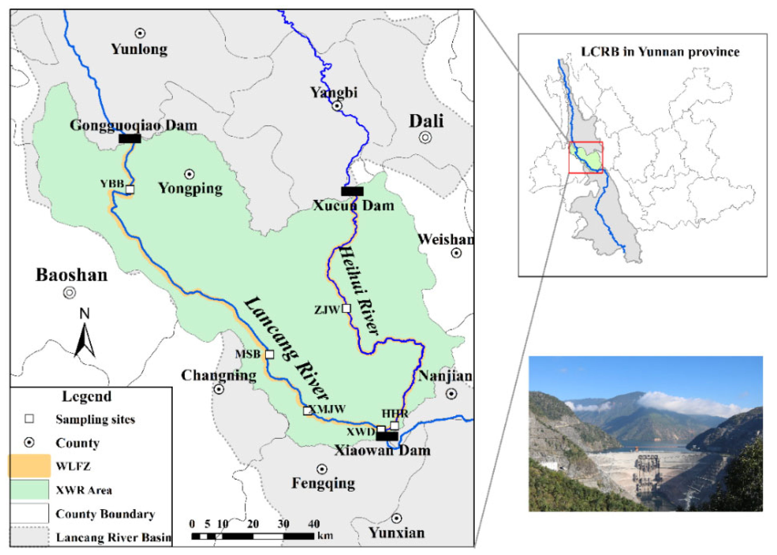
2.1. Study Area

The Xiaowan dam is located at the junction between the Fengqing and Nanjian counties of Yunnan Province, about 1.5 km downstream of the intersection between the Lancang River and Heihui River (Figure 1). The Xiaowan hydropower station is the second largest power station in the upper Mekong basin, with a crest length of 892.8 m and a dam height of 294.5 m, with an installed capacity of 4200 MW. The Xiaowan Dam construction started in January 2001 and its impoundment was completed from December 2008 to 31 August 2012. The backwater length of XWR is 179.6 km near the Gongguoqiao Dam site in the Lancang River and 125.3 km near the Xucun Dam in the Heihui River, respectively. The XWR covers an area of 189.1 km2 over eight districts and is mainly distributed through Fengqing, Changning, Longyang, and Nanjian counties. The total storage capacity of XWR is about 150.00 × 10⁸ m3 with a standard water level of 1240 m above sea level and its regulated storage capacity is 99.00 × 10⁸ m3. The XWR region is situated in the southwest mountainous gorge region of China, where the elevations of many mountains close to the XWR are higher than 2300 m, and the mainstream valley gradient ratio is over 15‰. The regional climate is a semi-tropical monsoon, with the annual average temperature ranging between 14.3 and 19 °C and annual precipitation ranging between 770 mm and 1330 mm, in different areas [49].

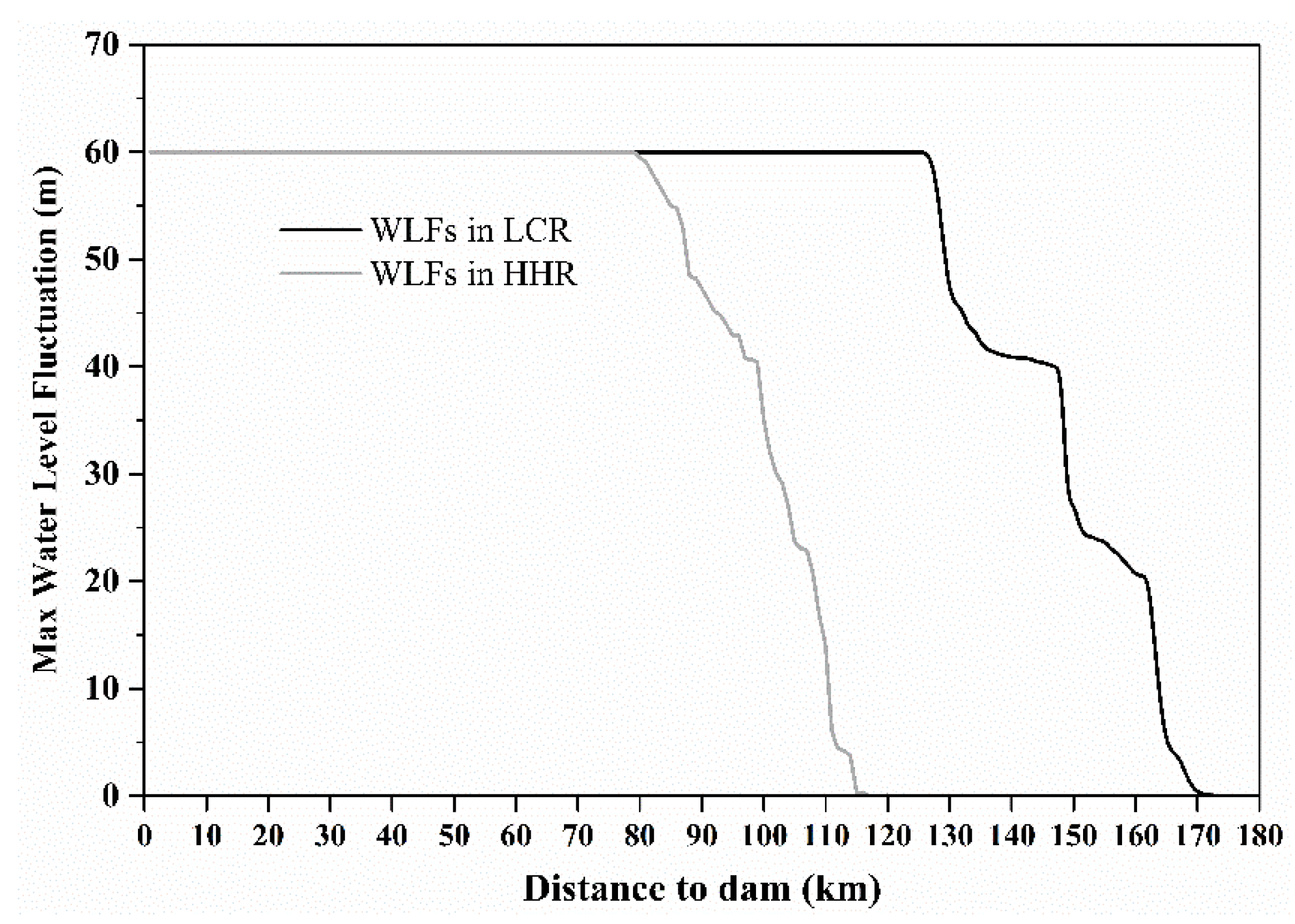
2.2. The Hydrologic Regime of XWR

Although power generation is the primary aim of the Xiaowan project, extensive added benefits presented itself, namely flood control, sediment trapping, and navigation. According to the annual operation program of XWR, a typical hydrological year consists of five stages: (1) P1, the water level drops gradually from 1240 m above sea level to 1180~1186 m above sea level from January to March due to reservoir emptying and drought; (2) P2, the water level is maintained at an approximately constant minimum level of 1180 m above sea level from April to May, to discharge the muddy water; (3) P3, the reservoir controls the water to keep the level at lower than 1232 m above sea level during June to mid-September, and then increase the water level to 1232~1240 m above sea level between mid-September and late October (P4); and (4) P4, the reservoir is fully impounded with a constant maximum level of approximately 1240 m above sea level during November to December (Figure 2). As a result, an artificial hydro-fluctuation belt (i.e., WLFZ) with a maximum vertical elevation difference of 60 m has been created. Owing to the changes in the river’s longitudinal elevation, the vertical height of WLFZ gradually decreases from 60 m at the dam site to 0 m at the terminal of the backwater that forms a natural river channel. Heretofore, the riparian zone of XWR has experienced seven full alternations of drying and wetting.

2.3. Soil Sampling and Chemical Analysis

Field sampling was conducted in May 2017 when the entire riparian zone was fully exposed. Six representative transects, specifically, near the Xiaowan Dam (XWD) site, Mangjie wharf (MJW), Manshui bridge (MSB), Yongbao bridge (YBB), Heihui River (HHR) and Zhujie wharf (ZJW), along XWR were selected as the sampling sites (Figure S1). At each cross-section, sequential sampling plots with 1 × 1 m grids were designed according to the topographical changes. Specifically, one sampling plot was selected for every elevation range with a vertical height of 5 m. Sampling plots included the complete lateral riparian zone from the maximum to minimum water level. A plastic shovel was used to sample soils in the riparian zone (0 to 10 cm). In every plot, soils from five points were sampled randomly to obtain a composite sample. In total, 87 composite soil samples were collected, placed in polyethylene bags, and sealed. The samples were then transferred to the lab, and immediately air-dried at room temperature. The dried soil was disaggregated, sieved using a 2 mm sieve, and subsequently resealed in polyethylene bags.
Before trace metal concentrations could be determined, digestion was performed with concentrated HCL-HNO3-HF-HClO (i.e., 5 mL HCL, 15 mL HNO3, 10 mL HF, and 5 mL HClO; HF represents the hydrofluoric acid) for all tested soils [50]. All the acids used in the digestion process were guaranteed reagent level (GR, 99.8%). After soil digestion, the concentrations of As, Cd, Cr, Cu, Ni, Pb, and Zn were measured utilizing the method of inductively coupled plasma atomic absorption spectrometry (ICPAES). The Hg concentration was determined with an automatic mercury analyzer RA-3 (NIC, Japan). In an attempt to ensure measurement accuracy and quality control, standard reference materials (GBW07401, Beijing, China) were consulted and the results showed that the analytical precision was within ±5% [27].

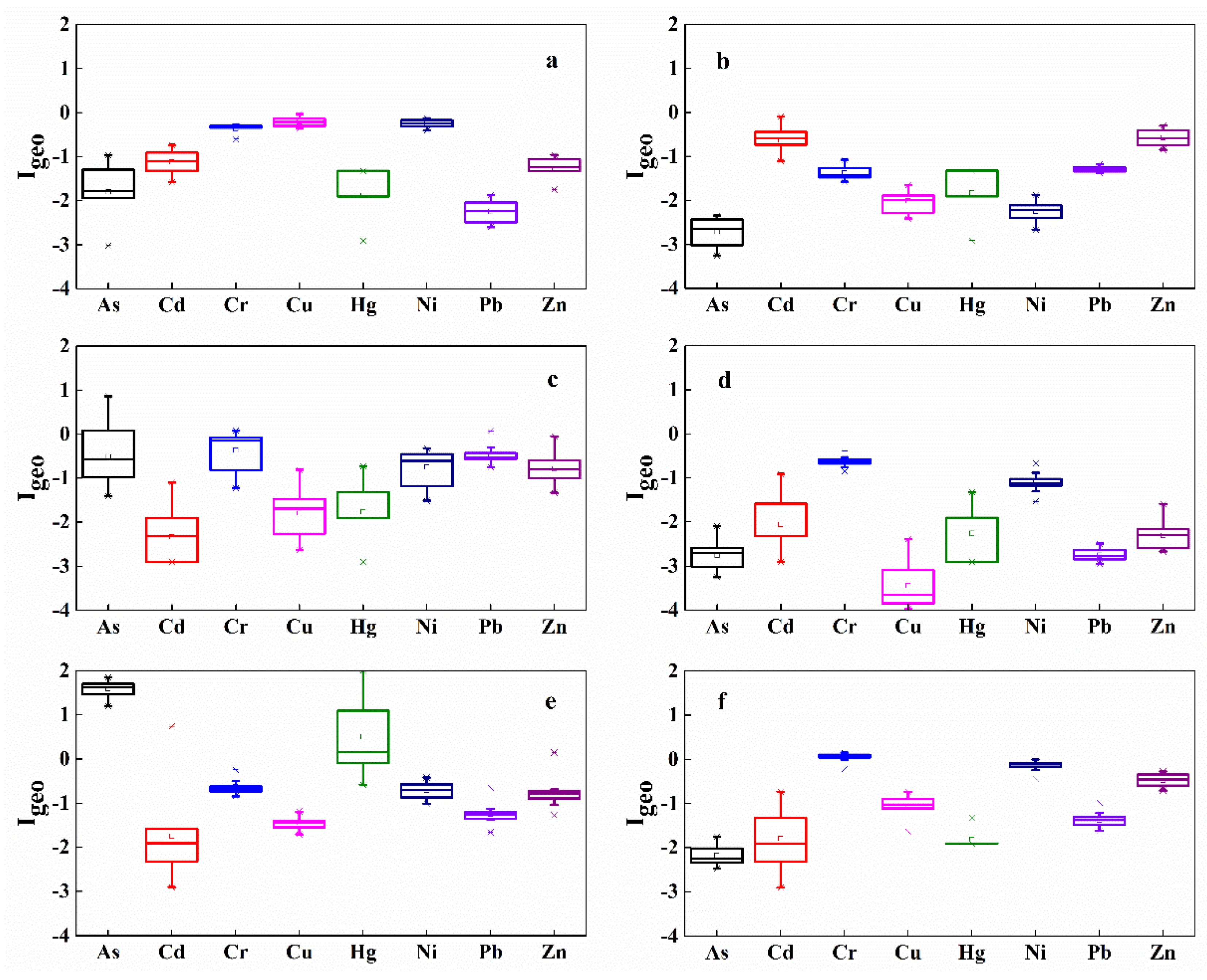
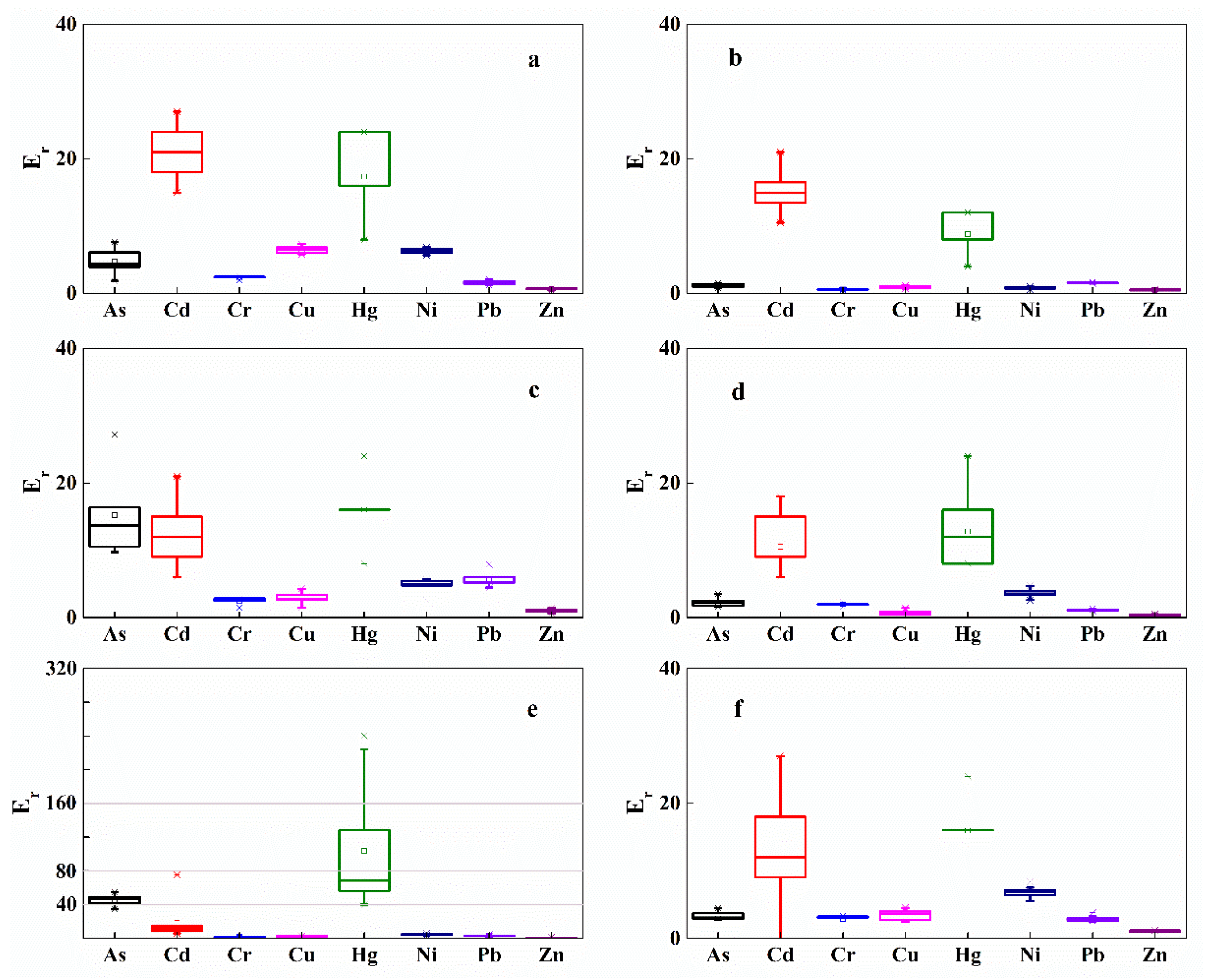
2.4. Contamination Evaluation

This study concerned itself with the evaluation of the accumulation of heavy metals in the riparian soils following an extended period of flooding. The metal concentrations in the soils were compared with their background values, referring to the samples taken from metal deposits in areas with a low level of human activity, to evaluate the pollution level of heavy metals. The regional heavy metals background concentrations in soils were obtained from the results of a national soil environmental background values investigation conducted in China by Wei [51], collecting a large number of samples and launching a statistical analysis of these samples (Table 1).
Considering the measured concentrations and background values, the geoaccumulation index (Igeo), as proposed by Muller (1969), was used to evaluate the level of heavy metal contamination in the riparian soils by applying the following equation:
I geo = l o g 2 C i 1.5 B i
The examined concentration in soils of the metal element i is represented by Ci, while Bi is the corresponding environmental background concentration for element i. According to the values of the calculated Igeo, the contamination level can be divided into seven degrees [52] (Table 2).
Furthermore, to evaluate the possible eco-toxicological effects of heavy metals in the soil on exposed organisms along the riparian zone, the potential ecological risk index (RI) [53] was also applied to assess the degree of heavy metal pollution. The RI is calculated by:
R I = i = 1 n E r i = i = 1 n T r i C f i = i = 1 n T r i C i B i
The potential ecological risk coefficient is represented by Eri for the given metal i; Tri is the toxic-response factor for the given metal element I; Cfi represents the contamination coefficient for a given metal I; and Ci and Bi represent the same meanings as Equation (1). Tri reflects the potential toxicity level for a given metal i. Tri is illustrated by Table 1.

2.5. Statistical Analysis

In order to compare the differences in the heavy metal content at different points, we counted the maximum and minimum value, mean value, and standard deviation of the heavy metal content at different sampling sections. Pearson’s correlation analysis was used to assess the relationships between different heavy metals.

3. Results

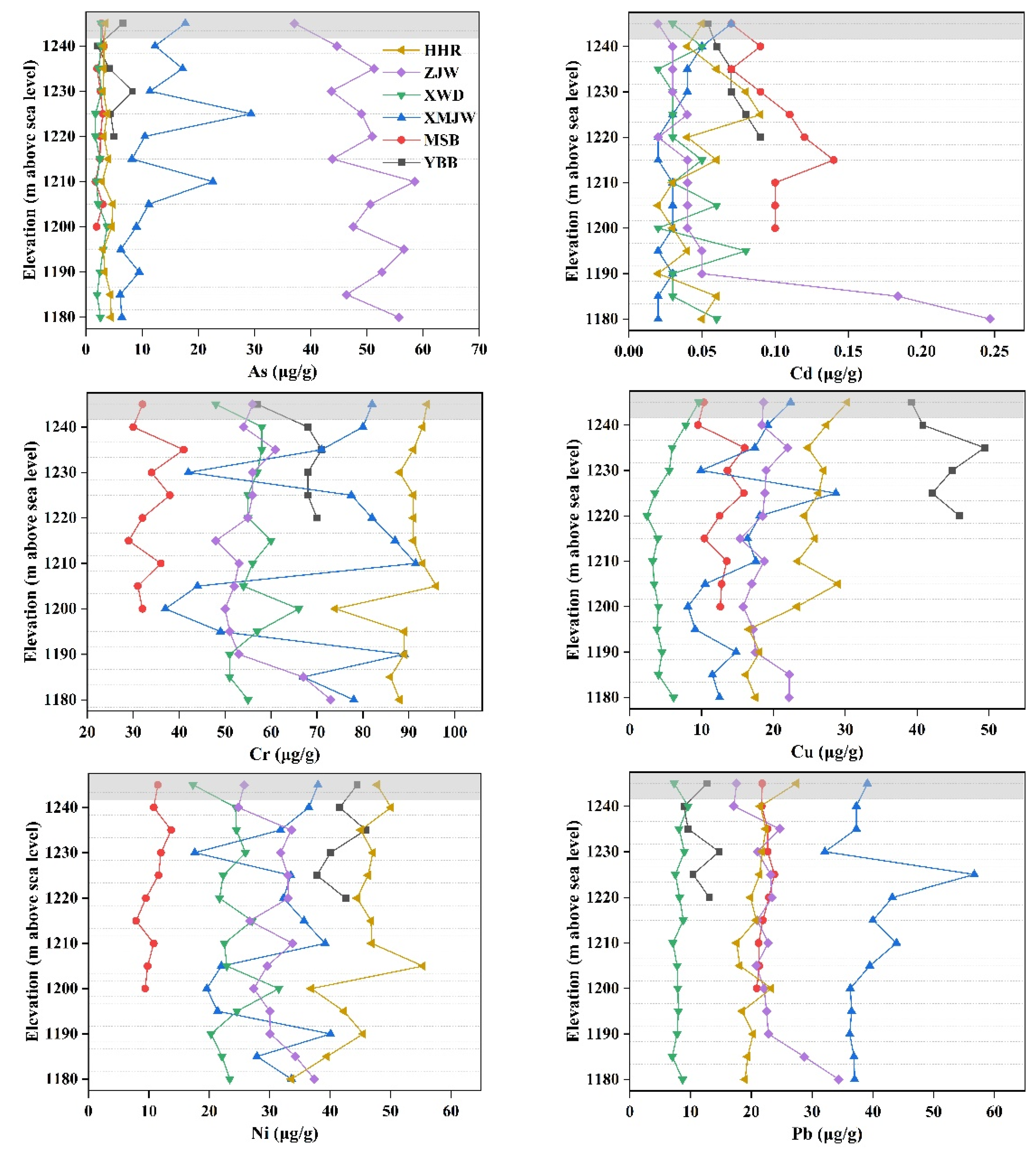
3.1. Distribution of Heavy Metal Concentrations in the Soil of the Riparian Zone

The concentrations of heavy metals in soils of the riparian zone displayed inconsistent modification trends with the decrease in elevation, whereas increasing trends were also observed (e.g., trace metals contents at the low attitudes for YBB, XWD, and ZJW) (Figure 3). In general, comparatively low heavy metals concentrations were detected in the soil of the riparian zone of XWR. In particular, the Cd concentration from all the sampling sites were lower than the regional background value. However, trace metals of As, Cr, Cu, Hg, Ni, Pb, and Zn at some sites were higher than the background value as shown in Table S1. Specifically, the trace metals with higher concentrations than the local background contents were As from MJW and ZJW; Cr from YBB, MJW and HHR; Cu from YBB; Hg from ZJW; Ni from YBB and HHR; Pb from MJW; and Zn from MSB and HHR. Table 3 indicates that the transect with peak mean concentrations for As, Cd, Cr, Cu, Hg, Ni, Pb and Zn were ZJW, MSB, HHR, YBB, ZJW, HHR, MJW, and HHR, respectively. Furthermore, Table S1 demonstrates that the concentrations of As, Cr, Cu, Ni, Pb, and Zn at the XWD were lower than that of all the other sampling sites. Also, Figure 3 revealed that no significant difference was detected for the heavy metal concentrations of soils between the WLFZ and the IRZ. However, significant differences in the trace metals concertations along different sampling sections were observed (p < 0.01, Table S1). Additionally, a significant difference in trace metal enrichment between LCR and HHR was detected (p < 0.01, Table S1). Pearson’ s correlation analysis revealed many significant positive correlations for all tested metals in the soil, especially among As, Cu, and Zn with other metals (Table 3). The significant correlations for some trace metals indicates that elements are highly homologous.

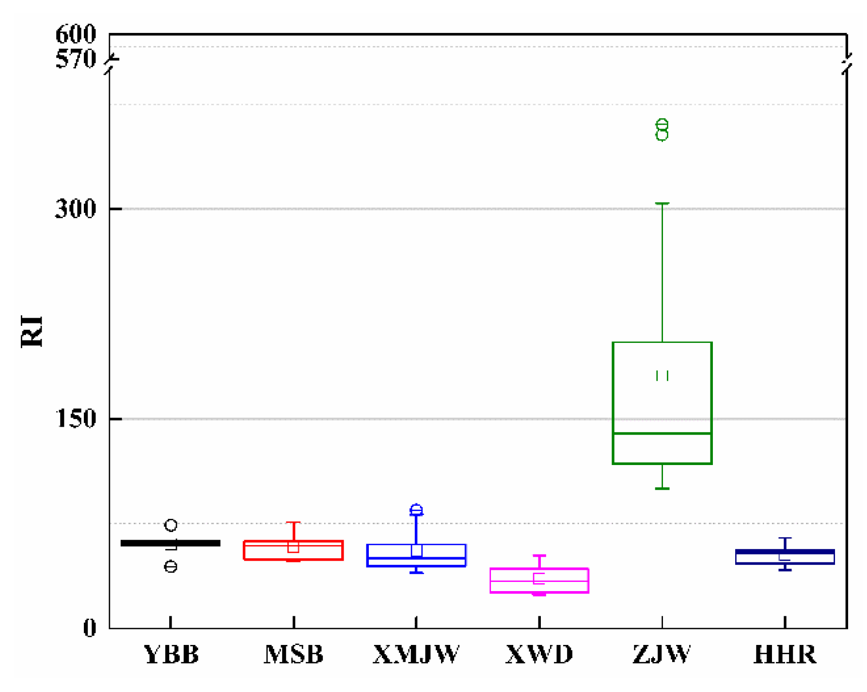
3.2. Trace Metal Enrichment of Riparian Soils and Metal Contamination Assessment

Contamination status was determined by calculating the Igeo values of the riparian soils using Equation (1), with different pollution degrees. The results show that the pollution degree of measured heavy metals in the riparian soils of WXR were relatively low (Figure 4). Igeo revealed that soils in the riparian zone of XWR were not polluted by Cd, Cu, Ni, Zn, or Pb and was consistent for all the sampling sites. However, slight contamination by Hg at the transect of ZJW and Cr at the transect of HHR, and moderate contamination by As at the section of ZJW were monitored (Figure 4).
The contaminated trace metals introduce potential toxic risk to the local ecosystem. However, the risk changes considerably when the varying levels of toxicity in different metals are taken into account even though the exposure levels are similar [11]. Thus, the present study evaluated the potential toxicological effects of soil heavy metals on the riparian zone ecosystem using RI defined by Equation (2). The Er value for the individual metal element and the total RI value for all measured metals were calculated to obtain the status of potential ecological risk. The results showed that the Er values of Cd, Cr, Cu, Ni, Zn, and Pb in riparian soils are below 40 for all sampling transects and indicated a potentially minor risk; As and Hg followed a low-risk level at the transects of YBB, MSB, MJW, XWD, and HHR, whereas As is a moderate risk and Hg is a high risk at the ZJW (Figure 5). Overall, the soils in the riparian zone of YBB, MSB, MJW, XWD, and HHR represented a minor risk to the local ecosystems, whereas the riparian soils at ZJW denoted a moderate risk (Figure 6). Furthermore, Figure 6 also demonstrates that RI is gradually decreasing from the upstream to XWD, which denotes the corresponding ecological risk changing for riparian soils of XWR.

4. Discussion

4.1. Lateral and Longitudinal Distribution of Heavy Metal Concentrations in the Riparian Soils

Usually, the geochemical loads, including the dissolved and particulate forms in the river system can be physically retained in the reservoir. This can be accomplished by water impounding and sediment trapping from upstream and the reservoir catchment area due to the dam operation and reservoir regulation [3,11,54]. The present study determined the level of heavy metal concentrations in the soil of the riparian zone of XWR and evaluated its enrichment distributions at different sites. The investigation results revealed that most of the heavy metals present in the riparian soils did not fall within the denoting pollution status, although several metals fell within an evidently higher status compared to local background values of trace metals. These results suggest the contribution of an external source to the concentration of heavy metals during the alternation between wet and dry seasons of the XWR project. Since XWR is located in a mountainous valley area and artificial disturbances in the riparian zone are not strong, the increased heavy metal contained in soil can be attributed to the chemical transformation of soluble fractions in the reservoir water column during the alternation between wetting and drying [11]. The physical adsorption from the contaminated sediments may lead to an increase in trace metal concentrations in the soil of the riparian zone.
The concentrations of heavy metals in the riparian soils at different elevations, illustrated by Figure 3, showed a small lateral variation as evident from the trace metal concentrations, although no statistically significant trend is visible. This result is in accordance with the investigation conducted in the riparian zone of the Manwan Reservoir, Lancang River by Liu et al. [13] and the examination of the riparian zone located at the Three Gorges Reservoir by Wang et al. [55]. However, the results differ from the study by Tang et al. [54], which demonstrated that the heavy metal concentrations in the riparian soils of TGR generally follow a slight decreasing trend with an increase in elevation. Ye et al. [12] reported that the riparian soil of TGR was moderately contaminated by As and Pb according to several indices, and dam operation and local human activity affect heavy metal distribution in the riparian zone. The latest case study from Nuozhadu Reservoir, reported that the concentrations of Cu and Ni in the WLFZ soils increased noticeably with the increasing elevations, while Cr and Zn tended to decrease with increasing elevations [56]. The Nuozadu Reservoir is located at downstream of the XWR, approximately 300 km from XWD. The different accumulation and redistribution of trace metals in the riparian soils between the XWR and the Nuozadu Reservoir can partly be due to the different land-use types and inundations durations. Several soil properties differed significantly with land-use types in WLFZ of the Nuozhadu reservoir [56]. Whereas the land-use types in the WLFZ of XWR are simple, the sampling sites of XWD, MSB, ZJW, and HHR were forest before inundation and the sampling sites of YBB and MJW were farmland before inundation. The single type of land-use results in homogeneous soil properties in the riparian zone of XWR.
In summary, this study believes that the metal content of the soils in the riparian zone is less affected by the upstream incoming water and sediment, and mainly determined by the nature of the local soil, and is closely related to the background value. At the same time, the metal content of the soil in the fluctuation zone is related to the flooding intensity at different elevations to a certain extent.

4.2. Influence of the Changed Hydrologic Processes on Heavy Metals Accumulation in Riparian Soils

Dam operation and local anthropological activities affect the heavy metals distribution in the riparian zone [12]. Changes in the flooding duration owing to reservoir operation leads to heavy metal accumulation in both the sediments and soil of the riparian zone [11,57]. Inundation, as a result of water level regulations and natural flooding, has promoted heavy metal accumulation in the riparian soils and sediments of TGR due to the reservoir operation [9,11,27,54,58]. The uncommon result garnered from this study might either be attributed to the inadequate submerging time of the trace metals for any influence on the variations in the water levels to become apparent [55,59], or to the sampling elevation distance in this investigation being too small to reflect substantial distinctions [13]. The regulated operation of water levels in the reservoir also influenced the trace metal concentrations of the riparian soils and sediments. The water level of XWR was maintained at a relatively low elevation of 1180 m for flood prevention from April to May before the rainy season commenced. The relatively prolonged flooding residence time in the lower regions of the riparian zone contributed to further heavy metal accumulation, being noticeable in the riparian soils in this low-lying area. However, during the flood season, the contaminated sediments and water with high trace metal concentrations produced from towns and agricultural areas were enriched at the lower positions of WLFZ, especially at the beginning of the rainy season [11,58,60,61]. Thus, the diffuse chemical loads accumulated in the riparian soil can become more obvious during several heavy rainfalls. In contrast, the pure sediment from bank erosion and clear water from areas upstream during the dry season leads to the inconspicuous accumulation of trace metals in the riparian soil [11].
Furthermore, the significant differences in the trace metal concentrations observed among the different sampling belts (Table S1), indicated the combined influence of human activities and natural factors on metal concentrations [11,18]. Considering the immovable attribute of soils in the riparian zone, trace metals accumulation in the soils can be explained by the chemisorption taking place from soluble portions in sediments and water from upstream. Additionally, vertical transfer of heavy metals from upper_layer sediments is partially responsible for heavy metal accumulation in the riparian soil [54]. However, the substantial difference in trace metal concentrations in soils of the riparian zone located at the tail, center, and head of XWR (Table S1) may be related to the fluctuation intensity of the water levels and flow velocity in different sections of the reservoir. The end of the reservoir is close to the natural river channel (Figure 7) with a rapid water flow velocity, and it is difficult for the heavy metals carried in the water body and sediments to be absorbed by riparian soils. Thus, the proportion of heavy metals present in riparian soils due to fluvial processes such as river transport and sedimentation is relatively small in the reservoir tail. Conversely, the deceleration of flow velocity in the reservoir center along with a significant amount of sedimentation increases the contact opportunity and adsorption time for trace metals in the riparian soils. Therefore, the trace metal concentrations in soils of the riparian zone displayed an increasing tendency (Table S1). Although the water flow rate slowed even further at the head of the reservoir, most of the sediment had already settled in the center of the reservoir. The heavy metals in the water are being diluted in the long-term hydrological process and, consequently, the riparian soil in the head area of the reservoir finds it challenging to adsorb trace metal elements from the sediments or inflows from upstream. Therefore, apparent heavy metals enrichment in the riparian soils at the head of XWR was not observed. Conversely, long-term water immersion leads to the release of heavy metals within dissolved portions in the soil and finally resulted in a decrease in the heavy metal contents. It is worth noting that the upper reaches of XWR, i.e., the Gongguoqiao Reservoir area, were severely polluted by the heavy metals Pb, Zn, Cd and As present in the soil, sediments, and water body. This contamination can be ascribed to the exploitation of the largest lead-zinc mining deposit in China, the Lanping Pb-Zn mines area in the Bijiang River basin [62]. Typically, the high-risk heavy metals contamination in the soils, sediments, and water of the river region upstream would lead to corresponding pollution in the downstream environmental mediums to varying degrees. However, the contamination assessments of Igeo and RI indicated that the riparian soils in the mainstream of LCR, from the reservoir tail to head, were not contaminated by the trace metals selected in this study (Figure 4&6). An important reason for this result is due to the Gongguoqiao Dam operation, which caused the chemical loads in both particulate and soluble forms. The chemical loads were physically retained during the hydrological regime by impounding water and trapping sediments from upstream and the catchment area of XWR.
A significant difference in trace metal enrichment was detected in LCR and HHR (Table 3). The concentrations of As and Hg in ZJW are significantly higher than the regional background value. Specifically, the rate of the measured value to the background was 4.56 for As and 2.59 for Hg, respectively. The trace metals of Cr, Ni and Zn also had relatively higher values than the local background values in HHR. These results implied the external input of contaminated water and sediments produced from the upper riparian zone or upstream artificial sources, for example, metal mining and smelting plants along the Heihui River, industrial wastewater (Heihui River is known as the “industrial corridor”), domestic sewage discharge and waste treatment from rural and urban settlements [13,40]. Furthermore, diffuse sources, including surface runoffs, dust diffusion of the road, atmospheric fallout, agricultural pollutants from fertilizer, pesticides and herbicides contributed to the contamination of soil in the riparian zone [11,13,40]. The development of fish farming in HHR after the XWR operation contributed to the relatively higher concentrations of As and Hg in ZJW and Pb, Ni, and Zn in HHR to a certain extent.
In conclusion, research into the discernible changes relating to the concentrations of heavy metals in the riparian soil of XWR was necessary to investigate the role of WLFs in combination with additional anthropogenic and natural factors. The results of the present study are beneficial in understanding the redistribution of heavy metals in the soil of the riparian zone of XWR as ascribed to the dam operation and reservoir filling. Heavy metal enrichment in the soils of the riparian zone is strongly associated with the water flow and sediments discharge from upstream. Hence, more detailed investigations are necessary to clarify the impact of WLFs on fluvial processes, especially the procedures of sedimentation, bank erosion, and chemical exchange of water_sediment_soils. The present results suggest that the dam closure and reservoir operation play a significant role in trace metals interception, although more specific evidence is needed to verify this.

5. Conclusions

Heavy metal contents were generally relatively low in the riparian soils of XWR and followed an inconsistent lateral decreasing trend, even though enriched concentrations were found for several metals. Significant differences in the trace metals concertations along different sampling sections were observed. Metal contamination assessment with Igeo indicated that the pollution degree of the measured heavy metals in the riparian soils of XWR were relatively low, while there were slightly polluted by Hg at the transect of ZJW and Cr at the transect of HHR, and moderately contaminated by As at the transect of ZJW. Cd, Cr, Cu, Ni, Zn, and Pb in riparian soils indicated a potentially minor risk for all sampling transects; As and Hg followed a low-risk level at the transects of YBB, MSB, MJW, XWD, and HHR, whereas As is a moderate risk and Hg is a high risk at the ZJW. The potential ecological risk index (RI) of the riparian soils revealed that As poses a moderate risk and Hg poses a high risk at ZJW. The XWR operating at full capacity has facilitated changes in the regional hydrological processes and the corresponding trace metals accumulation in the riparian zone. This study investigated the spatial pattern and contamination levels of soils in five typical sections of the riparian zone and confirmed their links to the altered water level processes. Polluted sediments and water introduced from upstream and upland contaminated sources are responsible for heavy metals accumulation in the riparian soils through chemisorption from solubilized fractions during the water_sediment_soils exchange processes following alternating wetting and drying due to reservoir operation. This study could assist in comprehending trace metal enrichment within the riparian soil of XWR attributed to the dam closure and reservoir impoundment. However, more rigorous examination is needed to elucidate the impact of WLFs on the chemical exchange of water_sediment_soils in the riparian zone.

Supplementary Materials

The following supporting information can be downloaded at: https://www.mdpi.com/article/10.3390/ijerph191912902/s1, Figure S1: The riparian soils sampling locations of Xiaowan Reservoir; Table S1: The statistics of the heavy metal concentrations in the riparian soils of XWR.

Author Contributions

Conceptualization, R.Z.; methodology, Y.Z. and R.Z.; investigation, F.W. and R.Z.; writing—original draft preparation, Y.Z. and R.Z.; writing—review and editing, X.D. and R.A. All authors have read and agreed to the published version of the manuscript.

Funding

This research was jointly funded by National Natural Science Foundation of China, grant number 41601296 and 41661099, and National Key R&D Program of China, grant number 2016YFA0601601, China Postdoctoral Science Foundation, grant number 2016M592720, and Applied Basic Research Foundation of Yunnan Province, grant number 2016FD11.

Acknowledgments

We would like to thank X.P. Cheng, G.H. Yang and B. Si for their assistance during fieldwork and laboratory analyses. We also thank Yoanna Li and two anonymous reviewers for their constructive suggestions and comments on early draft of this manuscript.

Conflicts of Interest

The authors declare no conflict of interest. The funders had no role in the design of the study; in the collection, analyses, or interpretation of data; in the writing of the manuscript, or in the decision to publish the results.

References

  1. Ciszewski, D.; Grygar, T.M. A Review of Flood-Related Storage and Remobilization of Heavy Metal Pollutants in River Systems. Water Air Soil Pollut. 2016, 227, 239. [Google Scholar] [CrossRef] [PubMed] [Green Version]
  2. Li, X.L.; Shen, H.L.; Zhao, Y.J.; Cao, W.X.; Hu, C.W.; Chen, S. Distribution and Potential Ecological Risk of Heavy Metals in Water, Sediments, and Aquatic Macrophytes: A Case Study of the Junction of Four Rivers in Linyi City, China. Int. J. Environ. Res. Public Health 2019, 16, 2861. [Google Scholar] [CrossRef] [PubMed] [Green Version]
  3. Shim, M.J.; Yang, Y.M.; Oh, D.Y.; Lee, S.H.; Yoon, Y.Y. Spatial distribution of heavy metal accumulation in the sediments after dam construction. Environ. Monit. Assess. 2015, 187, 733. [Google Scholar] [CrossRef] [PubMed]
  4. Zhang, W.; Long, J.H.; Zhang, X.; Shen, W.; Wei, Z. Pollution and Ecological Risk Evaluation of Heavy Metals in the Soil and Sediment around the HTM Tailings Pond, Northeastern China. Int. J. Environ. Res. Public Health 2020, 17, 7072. [Google Scholar] [CrossRef] [PubMed]
  5. Sayadi, M.H.; Rezaei, M.R.; Rezaei, A. Sediment Toxicity and Ecological Risk of Trace Metals from Streams Surrounding a Municipal Solid Waste Landfill. Bull. Environ. Contam. Toxicol. 2015, 94, 559–563. [Google Scholar] [CrossRef] [PubMed]
  6. Santos-Frances, F.; Martinez-Grana, A.; Zarza, C.A.; Sanchez, G.A.; Roji, P.A. Spatial Distribution of Heavy Metals and the Environmental Quality of Soil in the Northern Plateau of Spain by Geostatistical Methods. Int. J. Environ. Res. Public Health 2017, 14, 568. [Google Scholar] [CrossRef] [PubMed]
  7. Duan, X.W.; Zhang, G.L.; Rong, L.; Fang, H.Y.; He, B.Y.; Feng, D.T. Spatial distribution and environmental factors of catchment-scale soil heavy metal contamination in the dry-hot valley of Upper Red River in southwestern China. Catena 2015, 135, 59–69. [Google Scholar] [CrossRef]
  8. Wang, C.; Liu, S.L.; Zhao, Q.H.; Deng, L.; Dong, S.K. Spatial variation and contamination assessment of heavy metals in sediments in the Manwan Reservoir, Lancang River. Ecotoxicol. Environ. Saf. 2012, 82, 32–39. [Google Scholar] [CrossRef]
  9. Ye, C.; Li, S.Y.; Zhang, Y.L.; Zhang, Q.F. Assessing soil heavy metal pollution in the water-level-fluctuation zone of the Three Gorges Reservoir, China. J. Haz. Mat. 2011, 191, 366–372. [Google Scholar] [CrossRef]
  10. Zhang, L.P.; Ye, X.; Feng, H.; Jing, Y.H.; Ouyang, T.; Yu, X.T.; Liang, R.Y.; Gao, C.T.; Chen, W.Q. Heavy metal contamination in western Xiamen Bay sediments and its vicinity, China. Mar. Pollut. Bull. 2007, 54, 974–982. [Google Scholar] [CrossRef]
  11. Tang, Q.; Bao, Y.H.; He, X.B.; Zhou, H.D.; Cao, Z.J.; Gao, P.; Zhong, R.H. Sedimentation and associated trace metal enrichment in the riparian zone of the Three Gorges Reservoir, China. Sci. Total Environ. 2014, 479, 258–266. [Google Scholar] [CrossRef] [PubMed]
  12. Ye, C.; Butler, O.M.; Du, M.; Liu, W.Z.; Zhang, Q.F. Spatio-temporal dynamics, drivers and potential sources of heavy metal pollution in riparian soils along a 600 kilometre stream gradient in Central China. Sci. Total Environ. 2019, 651, 1935–1945. [Google Scholar] [CrossRef] [PubMed]
  13. Liu, S.L.; Wang, C.; Yang, J.J.; Zhao, Q.H. Assessing the heavy metal contamination of soils in the water-level fluctuation zone upstream and downstream of the Manwan Dam, Lancang River. J. Soil. Sediment. 2014, 14, 1147–1157. [Google Scholar] [CrossRef] [Green Version]
  14. Pringle, C. What is hydrologic connectivity and why is it ecologically important? Hydrol. Process. 2003, 17, 2685–2689. [Google Scholar] [CrossRef]
  15. Liu, L.; Li, F.S.; Xiong, D.Q.; Song, C.Y. Heavy metal contamination and their distribution in different size fractions of the surficial sediment of Haihe River, China. Environ. Geol. 2006, 50, 431–438. [Google Scholar] [CrossRef]
  16. Zhang, M.Y.; Cui, L.J.; Sheng, L.X.; Wang, Y.F. Distribution and enrichment of heavy metals among sediments, water body and plants in Hengshuihu Wetland of Northern China. Ecol. Eng. 2009, 35, 563–569. [Google Scholar] [CrossRef]
  17. Fu, K.D.; Wang, C.; Su, B.; Li, D.X.; Yang, W.H.; Li, M.Y.; Lu, J.X.; Li, D. Distribution and Pollution Assessment of Heavy Metals in Sand Sediment of Reservoir along the Middle and Lower Reaches of Lancang River. Ecol. Econ. 2016, 32, 163–168+191. [Google Scholar]
  18. Mays, P.A.; Edwards, G.S. Comparison of heavy metal accumulation in a natural wetland and constructed wetlands receiving acid mine drainage. Ecol. Eng. 2001, 16, 487–500. [Google Scholar] [CrossRef]
  19. Zhang, W.G.; Feng, H.; Chang, J.N.; Qu, J.G.; Xie, H.X.; Yu, L.Z. Heavy metal contamination in surface sediments of Yangtze River intertidal zone: An assessment from different indexes. Environ. Pollut. 2009, 157, 1533–1543. [Google Scholar] [CrossRef]
  20. Bao, Y.H.; Gao, P.; He, X.B. The water-level fluctuation zone of Three Gorges Reservoir A unique geomorphological unit. Earth Sci. Rev. 2015, 150, 14–24. [Google Scholar] [CrossRef]
  21. Wantzen, K.M.; Rothhaupt, K.O.; Mortl, M.; Cantonati, M.; Laszlo, G.T.; Fischer, P. Ecological effects of water-level fluctuations in lakes: An urgent issue. Hydrobiologia 2008, 613, 1–4. [Google Scholar] [CrossRef]
  22. Tang, Q.; Fu, B.J.; Collins, A.L.; Wen, A.B.; He, X.B.; Bao, Y.H. Developing a sustainable strategy to conserve reservoir marginal landscapes. Natl. Sci. Rev. 2018, 5, 10–14. [Google Scholar] [CrossRef] [Green Version]
  23. Evtimova, V.V.; Donohue, I. Water-level fluctuations regulate the structure and functioning of natural lakes. Freshw. Biol. 2016, 61, 251–264. [Google Scholar] [CrossRef]
  24. Hofmann, H.; Lorke, A.; Peeters, F. Temporal scales of water-level fluctuations in lakes and their ecological implications. Hydrobiologia 2008, 613, 85–96. [Google Scholar] [CrossRef] [Green Version]
  25. Leira, M.; Cantonati, M. Effects of water-level fluctuations on lakes: An annotated bibliography. Hydrobiologia 2008, 613, 171–184. [Google Scholar] [CrossRef]
  26. Logez, M.; Roy, R.; Tissot, L.; Argillier, C. Effects of water-level fluctuations on the environmental characteristics and fish-environment relationships in the littoral zone of a reservoir. Fund. Appl. Limnol. 2016, 189, 37–49. [Google Scholar] [CrossRef]
  27. Cheng, F.Y.; Liu, S.L.; Yin, Y.J.; Zhang, Y.Q.; Zhao, Q.H.; Dong, S.K. Identifying trace metal distribution and occurrence in sediments, inundated soils, and non-flooded soils of a reservoir catchment using Self-Organizing Maps, an artificial neural network method. Environ. Sci. Pollut. Res. 2017, 24, 19992–20004. [Google Scholar] [CrossRef] [PubMed]
  28. Ye, C.; Li, S.Y.; Zhang, Y.L.; Tong, X.Z.; Zhang, Q.F. Assessing heavy metal pollution in the water level fluctuation zone of China’s Three Gorges Reservoir using geochemical and soil microbial approaches. Environ. Monit. Assess. 2013, 185, 231–240. [Google Scholar] [CrossRef]
  29. Saha, J.K.S.R.; Coumar, M.V.; Dotaniya, M.L.; Kundu, S.; Patra, A.K. Assessment of heavy metals contamination in soil. In Soil Pollution—An Emerging Threat to Agriculture, in Environmental Chemistry for a Sustainable World; Lichtfouse, E., Schwarzbauer, J., Robert, D., Eds.; Springer: Singapore, 2017. [Google Scholar]
  30. Wrzesinski, D.; Ptak, M. Water level changes in Polish lakes during 1976–2010. J. Geogr. Sci. 2016, 26, 83–101. [Google Scholar] [CrossRef] [Green Version]
  31. Zhao, Q.H.; Liu, S.L.; Deng, L.; Dong, L.; Dong, S.K.; Wang, C. Soil degradation associated with water-level fluctuations in the Manwan Reservoir, Lancang River Basin. Catena 2014, 113, 226–235. [Google Scholar] [CrossRef]
  32. Furey, P.C.; Nordin, R.N.; Mazumder, A. Water level drawdown affects physical and biogeochemical properties of littoral sediments of a reservoir and a natural lake. Lake Reserv. Manag. 2004, 20, 280–295. [Google Scholar] [CrossRef]
  33. Gregory, S.V.; Swanson, F.J.; Mckee, W.A.; Cummins, K.W. An Ecosystem Perspective of Riparian Zones. Bioscience 1991, 41, 540–551. [Google Scholar] [CrossRef]
  34. Hupp, C.R.; Osterkamp, W.R. Riparian vegetation and fluvial geomorphic processes. Geomorphology 1996, 14, 277–295. [Google Scholar] [CrossRef]
  35. Naiman, R.J.; Decamps, H. The ecology of interfaces: Riparian zones. Annu. Rev. Ecol. Syst. 1997, 28, 621–658. [Google Scholar] [CrossRef] [Green Version]
  36. Brauns, M.; Garcia, X.F.; Pusch, M.T. Potential effects of water-level fluctuations on littoral invertebrates in lowland lakes. Hydrobiologia 2008, 613, 5–12. [Google Scholar] [CrossRef]
  37. Peintinger, M.; Prati, D.; Winkler, E. Water level fluctuations and dynamics of amphibious plants at Lake Constance: Long-term study and simulation. Perspect. Plant Ecol. 2007, 8, 179–196. [Google Scholar] [CrossRef]
  38. Coops, H.; Beklioglu, M.; Crisman, T.L. The role of water-level fluctuations in shallow lake ecosystems—Workshop conclusions. Hydrobiologia 2003, 506, 23–27. [Google Scholar] [CrossRef]
  39. Nilsson, C.; Reidy, C.A.; Dynesius, M.; Revenga, C. Fragmentation and flow regulation of the world’s large river systems. Science 2005, 308, 405–408. [Google Scholar] [CrossRef] [Green Version]
  40. Zhao, Q.H.; Liu, S.L.; Deng, L.; Yang, Z.F.; Dong, S.K.; Wang, C.; Zhang, Z.L. Spatio-temporal variation of heavy metals in fresh water after dam construction: A case study of the Manwan Reservoir, Lancang River. Environ. Monit. Assess. 2012, 184, 4253–4266. [Google Scholar] [CrossRef]
  41. Xu, Y.Y.; Zhang, M.; Wang, L.; Kong, L.H.; Cai, Q.H. Changes in water types under the regulated mode of water level in Three Gorges Reservoir, China. Quatern. Int. 2011, 244, 272–279. [Google Scholar] [CrossRef]
  42. Chen, J.G.; Wang, J.F.; Guo, J.Y.; Yu, J.; Zeng, Y.; Yang, H.Q.; Zhang, R.Y. Eco-environment of reservoirs in China: Characteristics and research prospects. Prog. Phys. Geog. 2018, 42, 185–201. [Google Scholar] [CrossRef]
  43. Shao, M.L.; Xie, Z.C.; Han, X.Q.; Cao, M.; Cai, Q.H. Macroinvertebrate community structure in Three-Gorges Reservoir, China. Int. Rev. Hydrobiol. 2008, 93, 175–187. [Google Scholar] [CrossRef]
  44. Riis, T.; Hawes, I. Relationships between water level fluctuations and vegetation diversity in shallow water of New Zealand lakes. Aquat. Bot. 2002, 74, 133–148. [Google Scholar] [CrossRef]
  45. Wang, W.D.; Yin, C.Q. The boundary filtration effect of reed-dominated ecotones under water level fluctuations. Wetl. Ecol. Manag. 2008, 16, 65–76. [Google Scholar] [CrossRef]
  46. Song, J.Y.; Fu, K.D.; Su, B.; Huang, Q.S.; Huang, J.C.; Zhang, J.L. Spatial distribution of heavy metal concentrations and pollution assessment in the bed loads of the Lancang River System. Acta Geogr. Sin. 2013, 68, 389–397. [Google Scholar]
  47. Zhang, J.L.; Fu, K.D.; Wang, B.; Chen, L.Q.; Song, J.Y.; Su, B. Assessment of heavy metal pollution of bed sediment in the Lancang River. Prog. Geogr. 2014, 33, 1136–1144. [Google Scholar]
  48. Fu, K.D.; Su, B.; He, D.M.; Lu, X.X.; Song, J.Y.; Huang, J.C. Pollution assessment of heavy metals along the Mekong River and dam effects. J. Geogr. Sci. 2012, 22, 874–884. [Google Scholar] [CrossRef]
  49. Wu, X.D.; He, D.M.; Yang, G.J.; Ye, L.L.; Zhu, C.L.; Jia, H.F.; Hu, J.M. Seasonal variability of water quality and metazooplankton community structure in Xiaowan Reservoir of the upper Mekong River. J. Limnol. 2014, 73, 167–176. [Google Scholar] [CrossRef] [Green Version]
  50. Allen, S.E. Chemical Analysis of Ecological Materials; Blackwell: Oxford, UK, 1989. [Google Scholar]
  51. Wei, F. Background Values of Elements in Soils of China; Environmental Science Press: Beijing, China, 1990; Volume 501. [Google Scholar]
  52. Ghrefat, H.A.; Abu-Rukah, Y.; Rosen, M.A. Application of geoaccumulation index and enrichment factor for assessing metal contamination in the sediments of Kafrain Dam, Jordan. Environ. Monit. Assess. 2011, 178, 95–109. [Google Scholar] [CrossRef]
  53. Hakanson, L. An ecological risk index for aquatic pollution control. A sedimentological approach. Water Res. 1980, 14, 975–1001. [Google Scholar] [CrossRef]
  54. Tang, Q.; Bao, Y.H.; He, X.B.; Wen, A.B. Heavy metal enrichment in the riparian sediments and soils of the Three Gorges Reservoir, China. Proc. Int. Assoc. Hydrol. Sci. 2015, 367, 244–250. [Google Scholar] [CrossRef]
  55. Wang, Y.C.; Lei, B.; Yang, S.M.; Zhang, S. Concentrations and pollution assessment of soil heavy metals at different water-level altitudes in the draw-down areas of the Three Gorges Reservoir. Environ. Sci. Pollut. Res. 2012, 33, 612–617. [Google Scholar]
  56. Song, J.Y.; Duan, X.W.; Han, X.; Li, Y.M.; Li, Y.M.; He, D.M. The accumulation and redistribution of heavy metals in the water-level fluctuation zone of the Nuozhadu Reservoir, Upper Mekong. Catena 2019, 172, 335–344. [Google Scholar] [CrossRef]
  57. Chu, L.M.; Chang, C.; Xie, Z.Q.; Xiong, G.M. Effect of impounding of the Three-Gorges Reservoir on soil heavy metals in its hydro fluctuation belt. Acta Pedol. Sin. 2011, 48, 192–196. [Google Scholar]
  58. Pei, S.X.; Jian, Z.J.; Guo, Q.S.; Ma, F.Q.; Qin, A.L.; Zhao, Y.J.; Xin, X.B.; Xiao, W.F. Temporal and spatial variation and risk assessment of soil heavy metal concentrations for water-level-fluctuating zones of the Three Gorges Reservoir. J. Soil Sediment. 2018, 18, 2924–2934. [Google Scholar] [CrossRef]
  59. Wang, X.Y.; Fu, W.L.; Xie, F.; Pu, P.; Peng, J.T. The distribution characteristic of soil heavy metals and their influencing factors in water-level fluctuating zones of the Three Gorges reservoir area. Res. Soil Water Conserv. 2010, 17, 267–270. [Google Scholar]
  60. Kuusisto-Hjort, P.; Hjort, J. Land use impacts on trace metal concentrations of suburban stream sediments in the Helsinki region, Finland. Sci. Total Environ. 2013, 456, 222–230. [Google Scholar] [CrossRef] [PubMed]
  61. Marttila, H.; Saarinen, T.; Celebi, A.; Klove, B. Transport of particle-associated elements in two agriculture-dominated boreal river systems. Sci. Total Environ. 2013, 461, 693–705. [Google Scholar] [CrossRef]
  62. Cheng, X.F.; Danek, T.; Drozdova, J.; Huang, Q.R.; Qi, W.F.; Zou, L.L.; Yang, S.R.; Zhao, X.L.; Xiang, Y.G. Soil heavy metal pollution and risk assessment associated with the Zn-Pb mining region in Yunnan, Southwest China. Environ. Monit. Assess. 2018, 190, 194. [Google Scholar] [CrossRef]
Figure 1. The Xiaowan Reservoir area in the Lancang River and the sampling locations.
Ijerph 19 12902 g001
Figure 2. The changes in the water level by regular dam operation in the Xiaowan Reservoir. (a) Annual water level changes. (b) Water-level fluctuations zone.
Ijerph 19 12902 g002
Figure 3. The lateral distribution of the heavy metal concentrations in the riparian soils at different sites: YBB, MSB, MJW, XWD, ZJW, and HHR. The plots with gray marks represent the infralittoral reference zone (IRZ).
Ijerph 19 12902 g003aIjerph 19 12902 g003b
Figure 4. Box-whisker plots of Igeo values for different heavy metals in the riparian soils of XWR (The small letters (af) represent the same meaning as mentioned in Figure 3).
Ijerph 19 12902 g004
Figure 5. Box-whisker plots of Er values for different heavy metals in soils of the riparian zone (The small letters (af) represent the same meaning as mentioned in Figure 3).
Ijerph 19 12902 g005
Figure 6. Box-whisker plots of RI values and the corresponding ecological risk for riparian soils at different sampling sites.
Ijerph 19 12902 g006
Figure 7. The maximum water level fluctuations in the Lancang River and Heihui River of XWR.
Ijerph 19 12902 g007
Table 1. Geochemical background value and toxicity coefficient of heavy metals in soils of Yunnan Province, China.
ElementAsCdCrCuHgNiPbZn
Background value (mg/kg)10.80.157.633.60.0533.436.080.5
Toxicity coefficient (Tri)10302540551
Table 2. The calculated indexes responding to the contamination status and potential ecological risk levels.
Igeo ValueIgeo ClassContamination StatusEri ValueRI ValueEcological Risk Level
≤00UP≤40≤150Low
0–11UP-MP40–80150–300Moderate
1–22MP80–160300–600High
2–33MP-SP160–320>600Very high
3–44SP>320 Extremely High
4–55SP-EP
>56EP
UP: Unpolluted; UP-MP: Unpolluted to moderately polluted; MP: Moderately polluted; MP-SP: Moderately to strongly polluted; SP: Strongly polluted; SP-EP: Strongly to extremely polluted; EP: Extremely polluted.
Table 3. The correlation matrix amongst the heavy metal concentrations in the riparian soils.
AsCdCrCuHgNiPbZn
As1
Cd−0.221
Cr0.18−0.24 *1
Cu0.43 **0.210.56 **1
Hg0.66 **0.02−0.050.27 *1
Ni0.33 **−0.0950.91 **0.77 **0.141
Pb0.58 **-.1100.160.232*0.24 *0.111
Zn0.24*0.36 **0.33 **0.60 **0.200.36 **0.57 **1
* means the 0.05 level of significance, ** means the 0.01 level of significance.
Publisher’s Note: MDPI stays neutral with regard to jurisdictional claims in published maps and institutional affiliations.

