


Experiencing Public Spaces in Southern Chile: Analysing the Effects of the Built Environment on Walking Perceptions


Abstract
1. Introduction
1.1. Built Environment and Walkability
1.2. The Built Environment and Its Effects on Walking Perceptions
2. Materials and Methods
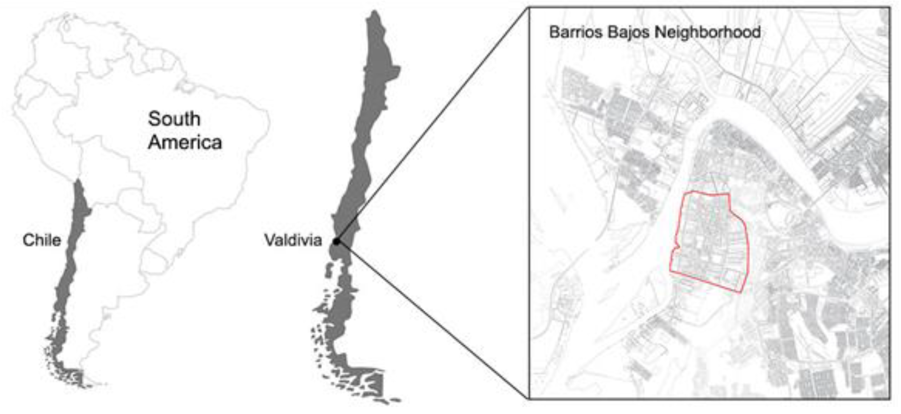
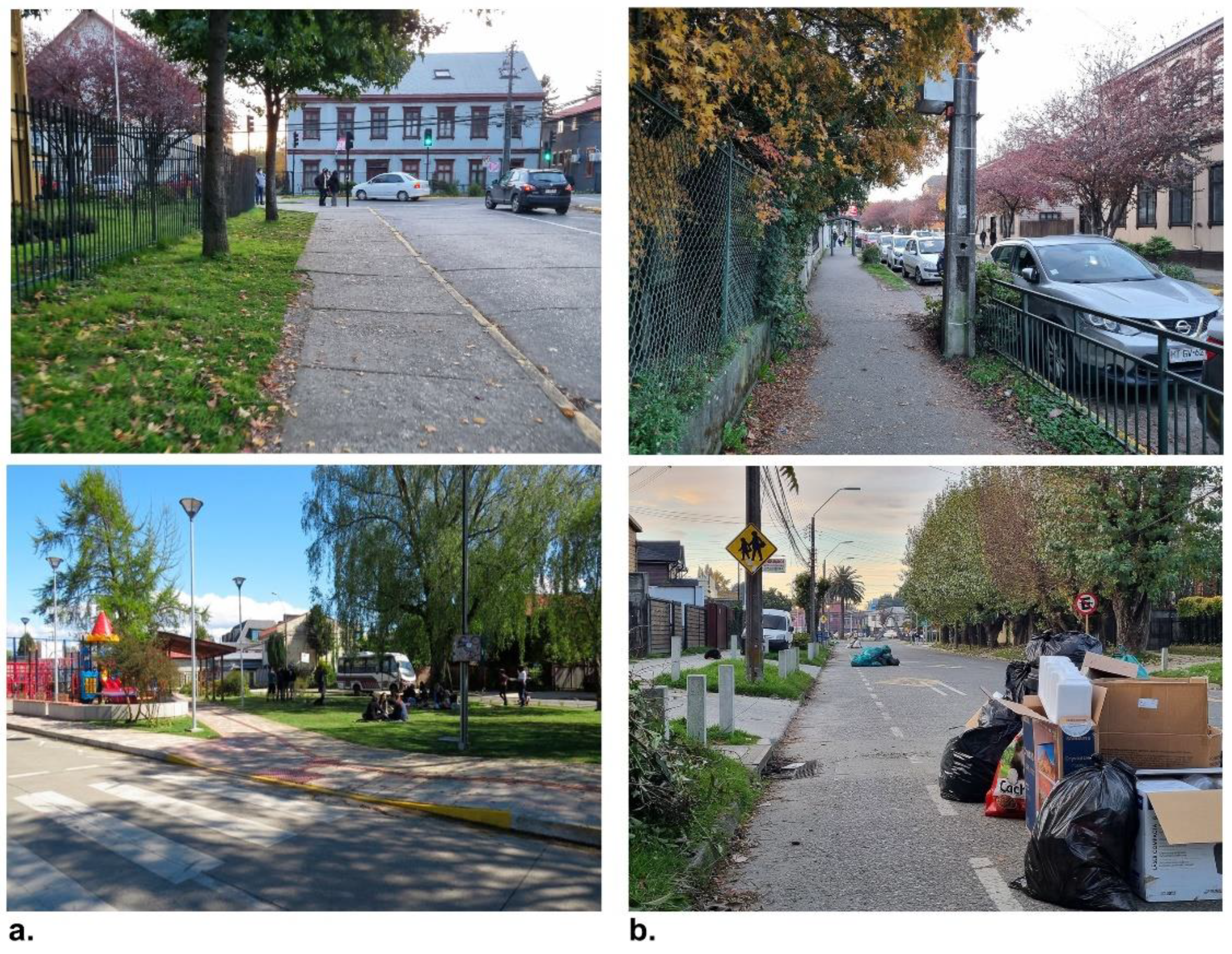
2.1. Case Study
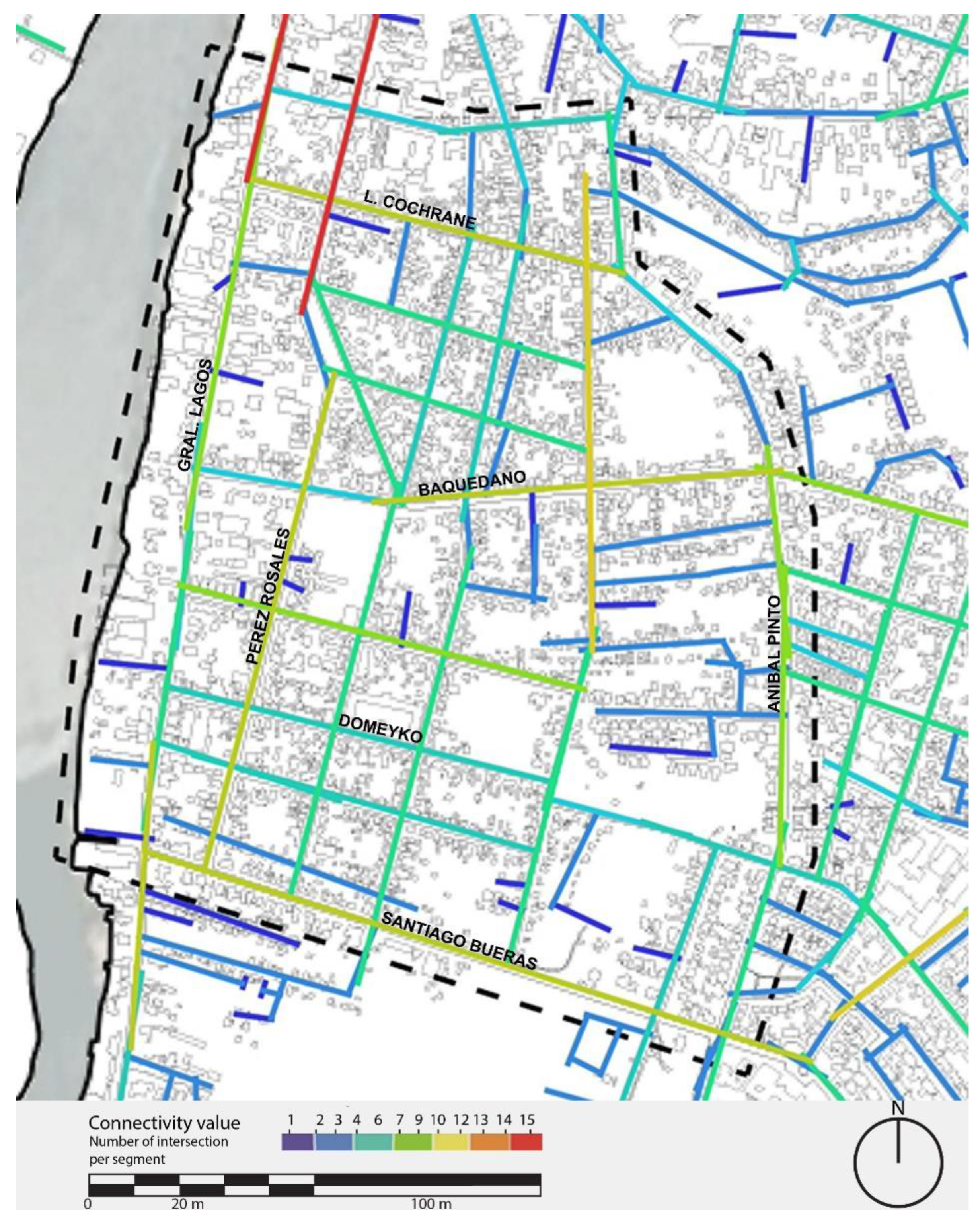
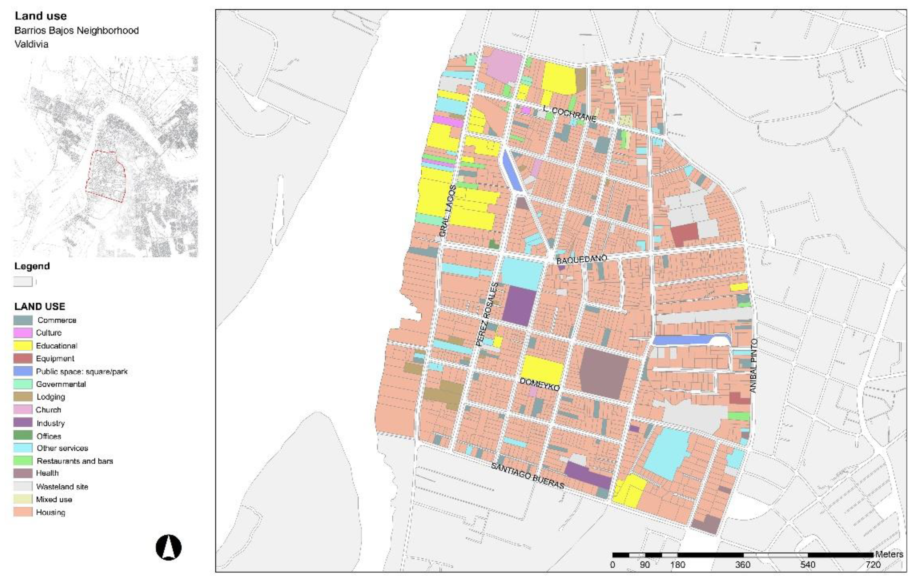
2.2. Methods
N(N − 1)
- D = diversity;
- n = number of individuals in each unit;
- N = total number of individuals in all units.
3. Results
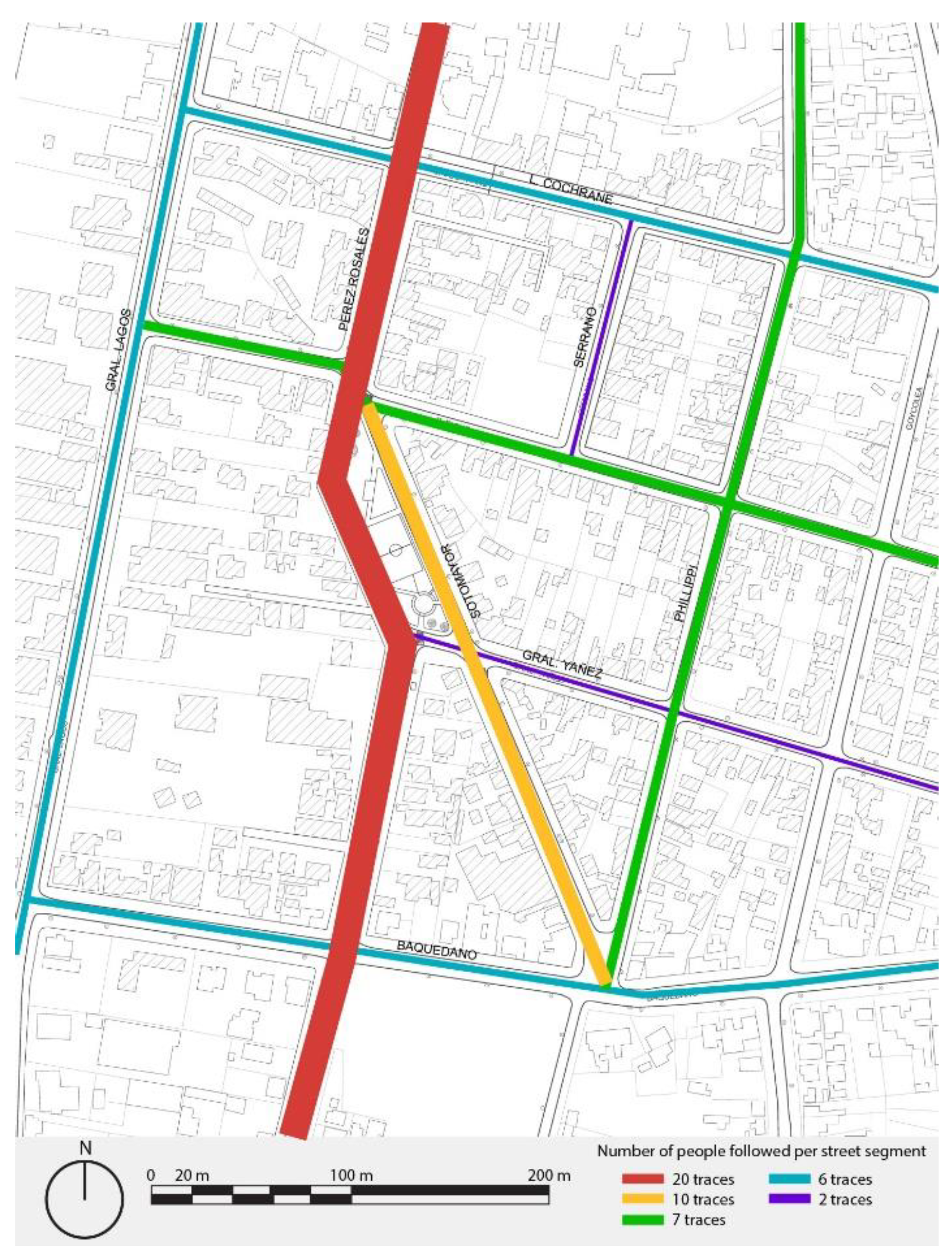
3.1. Assessing Choices of Route: People Following
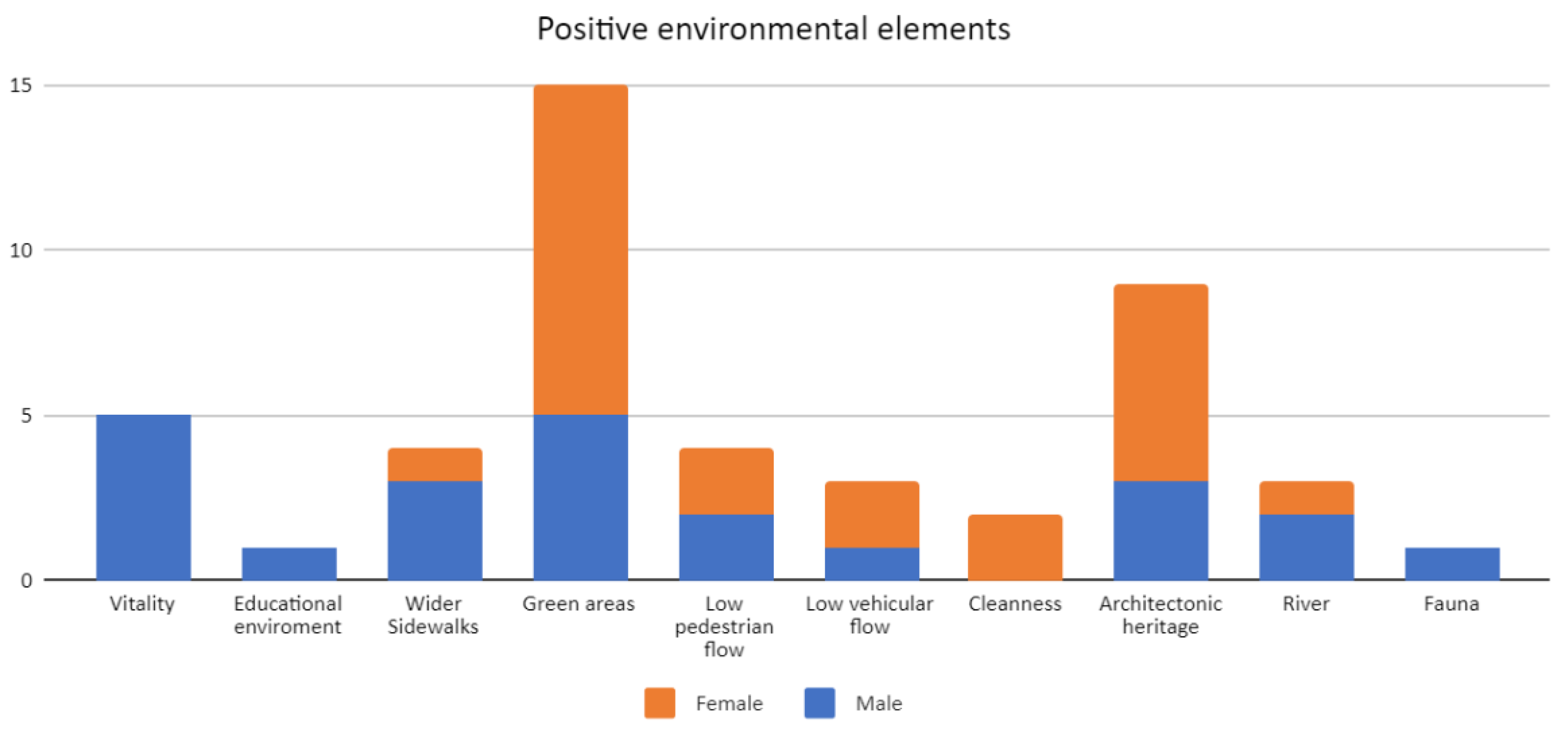
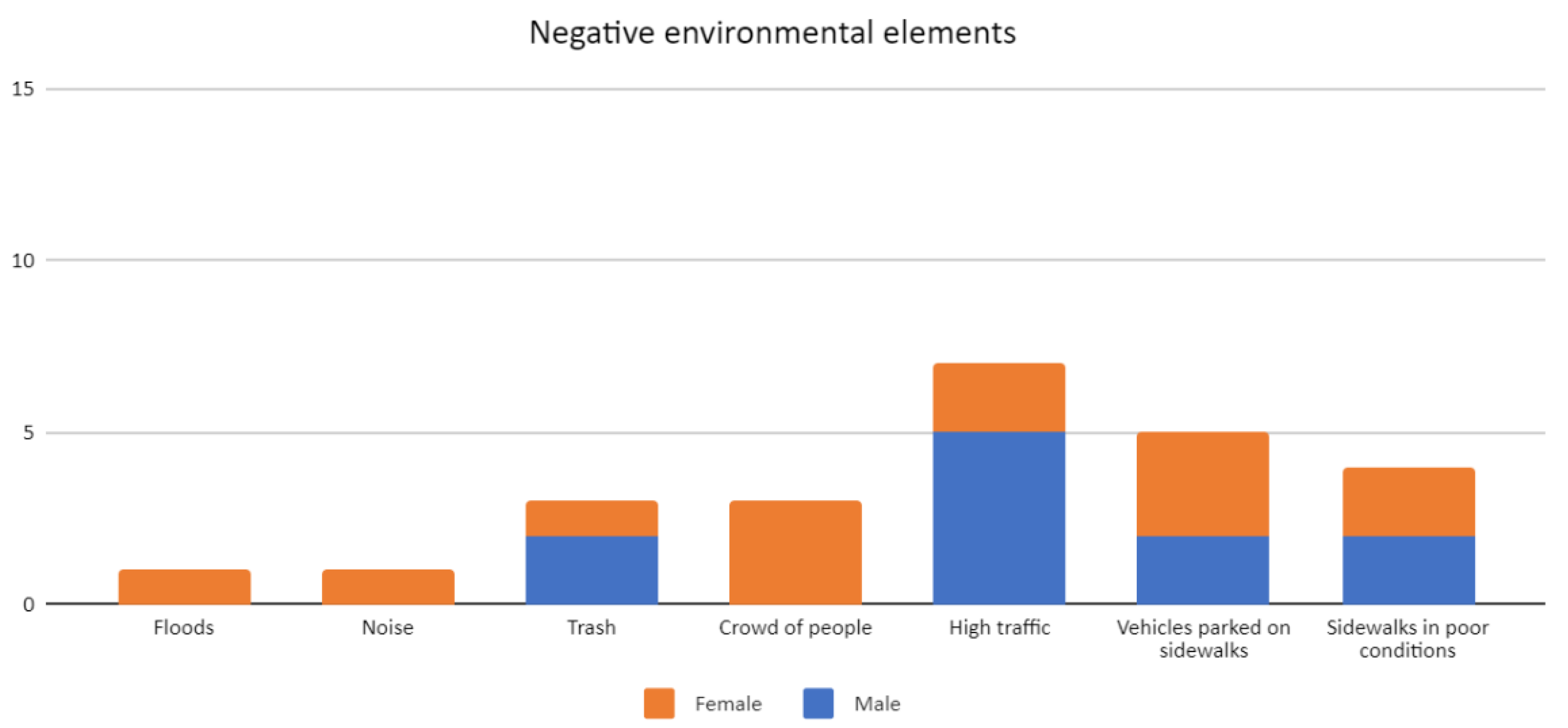
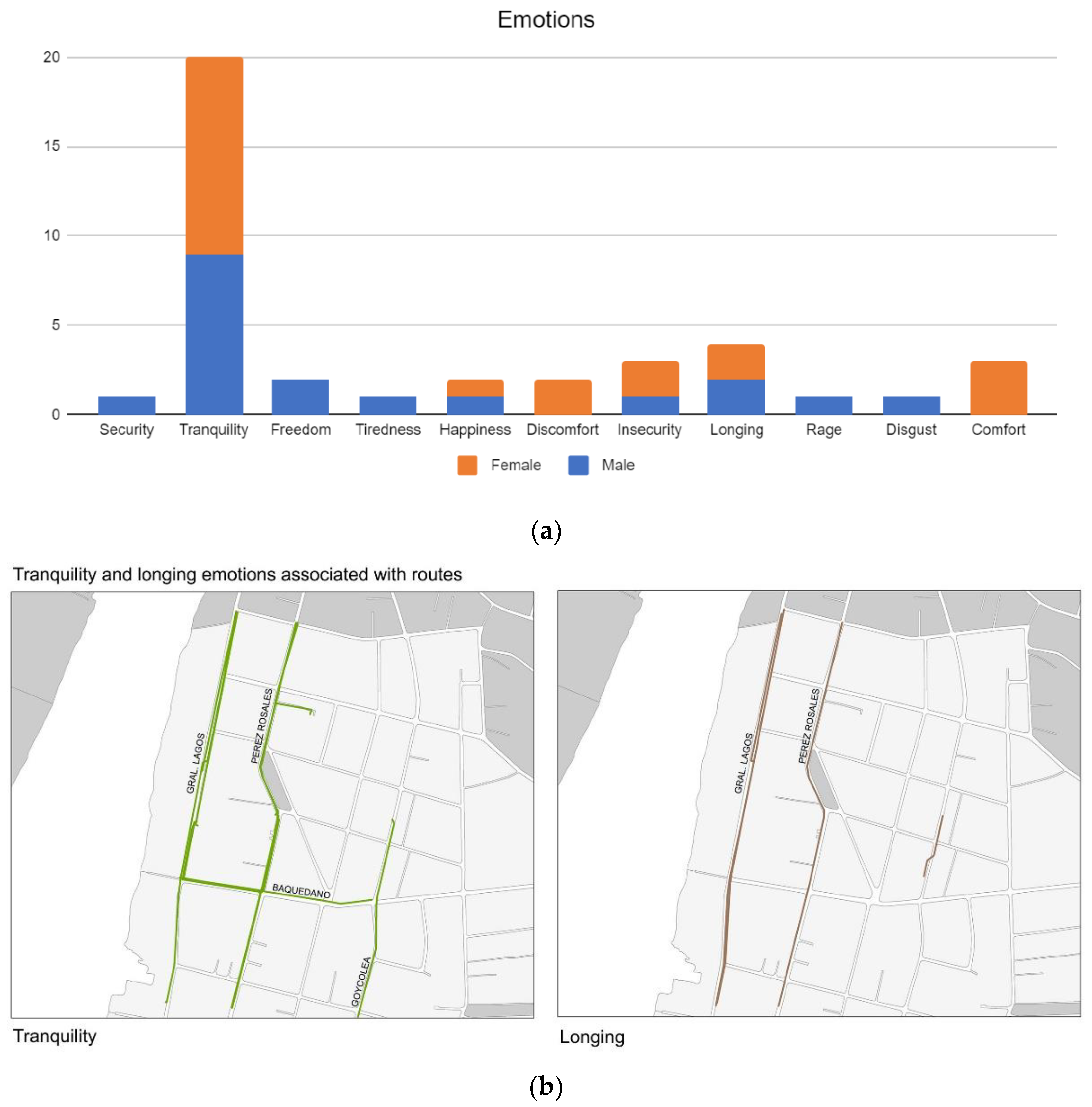
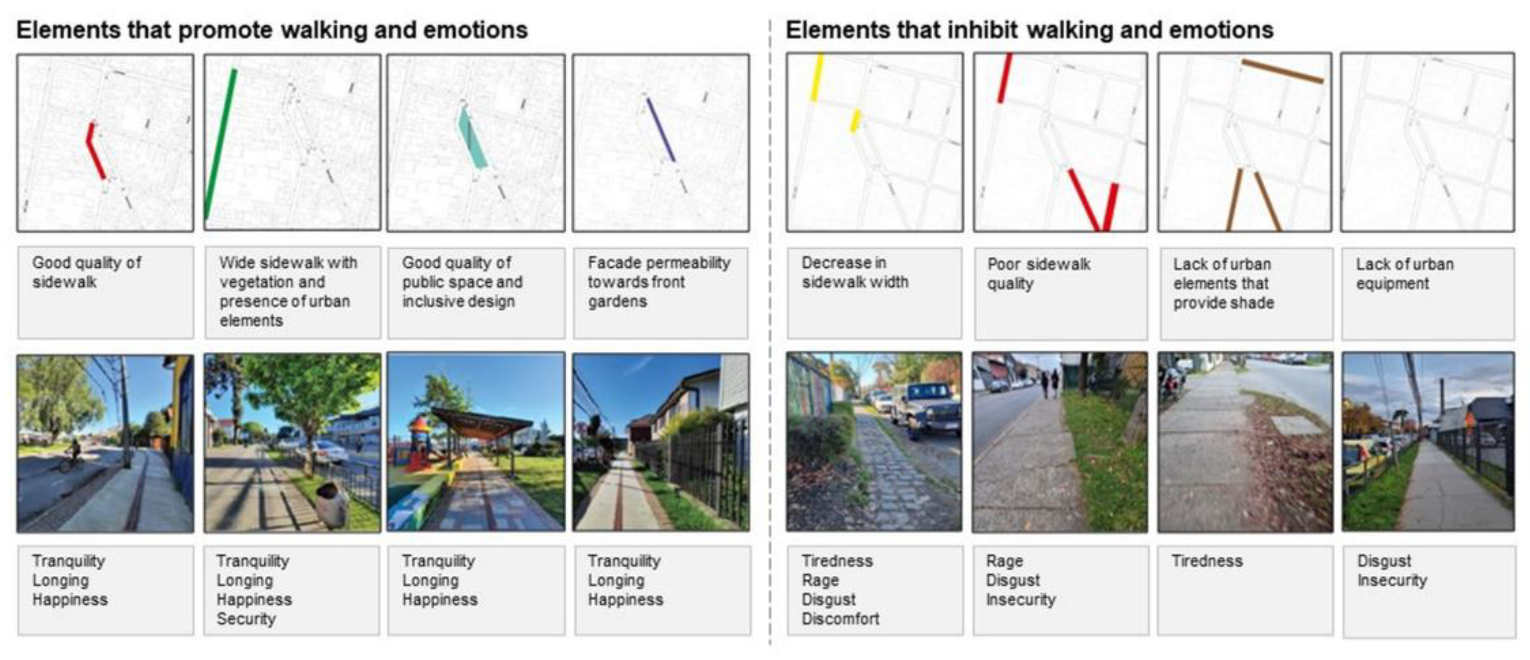
3.2. Assessing Pedestrian Perception: Walking Interview—Natural Go-Along Method
“Seeing the colors (of the facades and trees), the street is small, cozy, I don’t know how to say it, well, and since there are plenty of people it feels like a street that has a lot of life. It is difficult to describe it, but it is like that, that the city is alive, that the street is alive, there are relationships, things happen”.
“I feel nostalgic walking down this street because I’ve spent my whole life here, it’s still a super old street, my whole family lived here”.Words of a 51 year-old woman.
“I have lived a long time in this sector[...]. I like the fact that they are not large buildings, that there are no skyscrapers and that they are low-rise buildings. So, I like the style and it makes me happy to walk by this street”.Words of a 23 year-old woman.
“I love the colors of the facades, the street is like little, like cozy[...], it feels like a street that has a lot of life”.Words of a 21 year-old man.
“I like to walk down this street because it is quiet, there are many trees in some parts”Words of a 41 year-old woman.
“I like to walk around here because there is a diversity of trees and plants, and it is generally quiet”.Words of a 30 year-old man.
“I don’t know, there is a lot of vegetation like here, there are many types of plants and things like that [...]. Group of trees, shadows and the leaves of the trees, it gives me a feeling of tranquility walking here, of peace”Words of a 19 year-old man.
“The garbage [...]. Makes me feel like the street is dirty and not kept up [...]. It generates me like anger, disgust, that is”.
“There are times when the street narrows and many people come past and we have to go down the street, go up the sidewalk again. then it is quite dangerous”.
“I value this route because there are not so many people and that in reality, I do not like walking through such crowded streets”.Words of a 19 year-old woman.
“I like this street because there are a lot of people, there is a lot of traffic anyway, it feels like a street that has a lot of life”.Words of a 21 year-old man.
“What I value most when walking this route is the movement, seeing lots of people, more students, there are lots of people”.Words of a 23 year-old man.
4. Discussion
5. Conclusions
Author Contributions
Funding
Institutional Review Board Statement
Informed Consent Statement
Data Availability Statement
Acknowledgments
Conflicts of Interest
References
- Ministry of Finance. Chile: Financial Strategy on Climate Change; Ministry of Finance—Inter-American Development Bank: Santiago, Chile, 2019; Available online: https://cambioclimatico.mma.gob.cl/wp-content/uploads/2020/12/Financial-Strategy-on-Climate-Change-Chile-EN.pdf (accessed on 13 September 2021).
- Shekhar, H.; Rautela, M.; Maqsood, M.; Paris, R.; Flores, R.; Romero-Aguirre, M.; Balinos, M.; Estrada, M.; Salehi, G.; Rahman, T.; et al. Are leading urban centers predisposed to global risks—An analysis of the global south from COVID-19 perspective. Habitat Int. 2022, 121, 102517. [Google Scholar] [CrossRef] [PubMed]
- Zumelzu, A.; Barría, T.; Barrientos, M. Efectos de la forma urbana sobre la accesibilidad peatonal en barrios del Sur de Chile. Arquitetura Rev. 2020, 16, 1–22. [Google Scholar] [CrossRef]
- Nuñez, F.; Albornoz, E.; León, J.; Zumelzu, A. Socially sustainable mobility: Strategic analysis to identify accessibility barriers. Sustain. Cities Soc. 2022, 76, 103420. [Google Scholar] [CrossRef]
- Hosni, J.; Zumelzu, A. Assessing nodality in neighborhoods of transformation: A concept of sustainable urban form. The case study of Rahue Bajo, Osorno, Chile. Sustain. Dev. 2019, 27, 214–226. [Google Scholar] [CrossRef]
- Zecca, C.; Gaglione, F.; Laing, R.; Gargiulo, C. Pedestrian routes and accessibility to urban services. Rhythmic analysis on people’s behaviour before and during the COVID-19. J. Land Use Mob. Environ. 2020, 13, 241–256. [Google Scholar]
- Fatmi, R.M. COVID-19 impact on urban mobility. J. Urban Manag. 2021, 9, 270–275. [Google Scholar] [CrossRef]
- Baobeid, A.; Koc, M.; Al-Ghamdi, S.G. Walkability and its relationships with health, sustainability, and liveability: Elements of physical environment and evaluation frameworks. Front. Built Environ. 2021, 7, 721218. [Google Scholar] [CrossRef]
- Ministry of Housing and Urbanism. Política Nacional de Desarrollo Urbano. Ciudades Sustentables y Calidad de Vida; MINVU: Santiago, Chile, 2014. [Google Scholar]
- Zumelzu, A.; Herrmann-Lunecke, G. Mental well-being and the influence of place: Conceptual approaches for the built environment for planning healthy and walkable cities. Sustainability 2021, 13, 6395. [Google Scholar] [CrossRef]
- SECTRA, Programa de Vialidad y Transporte Urbano. Encuestas de Movilidad; Ministerio de Transportes y Telecomunicaciones: Santiago, Chile, 2018. [Google Scholar]
- Cámara Chilena de la Construcción. Infraestructura Crítica para el Desarrollo; Cámara Chilena de la Construcción: Santiago, Chile, 2014; Available online: https://cchc.cl/uploads/archivos/archivos/Infraestructura-Critica-para-el-Desarrollo_2014-2018.pdf (accessed on 12 October 2021).
- Herrmann-Lunecke, M.G.; Mora, R.; Véjares, P. Identificación de elementos del paisaje urbano que fomentan la caminata en Santiago. Rev. Urban. 2020, 43, 4–25. [Google Scholar] [CrossRef]
- Zumelzu, A.; Barrientos-Trinanes, M. Analysis of the effects of urban form on neighborhood vitality: Five cases in Valdivia, Southern Chile. J. Hous. Built Environ. 2019, 34, 897–925. [Google Scholar] [CrossRef]
- Pizarro, L.; Díaz, V.; Zumelzu, A.; Prieto, A.J. Resilience and sustainability assessment of cultural heritage and built environment: The Libertad pedestrian walkway in Valdivia, Chile. J. Cul. Herit. 2022, 53, 154–164. [Google Scholar] [CrossRef]
- COES. Módulo de Salud y Bienestar del Estudio Longitudinal Social de Chile (Elsoc); El Centro de Estudios del Conflicto y la Cohesión Social: Santiago, Chile, 2018; Available online: https://coes.cl/destacado-uno-de-cada-cinco-chilenos-reporta-sintomas-de-depresion/ (accessed on 28 May 2022).
- Estay, S.; Ruiz-Aravena, M.; Baader, T.; Gotelli, M.; Heskia, C.; Olivares, J.C.; Rivera, G. Socioeconomic and environmental contexts of suicidal rates in a latitudinal gradient: Understanding interactions to inform public health interventions. J. Psychiatr. Res. 2022, 148, 45–51. [Google Scholar] [CrossRef] [PubMed]
- IDB. Valdivia Capital Sostenible: Plan de Acción; ICES: Singapore; Emerging Sustainable Cities Action Plan: Valdivia, Chile, 2015; Available online: https://www.iadb.org/es/ciudades/planesdeaccion (accessed on 8 January 2019).
- Franchi-Arzola, I.; Martin-Vide, J.; Henríquez, C. Sustainability assessment in development planning in sub-national territories: Regional development strategies in Chile. Sustainability 2018, 10, 1398. [Google Scholar] [CrossRef]
- Vaughan, L. Space Syntax Observation Manual; Bartlett School of Architecture, UCL: London, UK, 2001. [Google Scholar]
- Al Sayed, K.; Turner, A.; Hillier, B.; Iida, S.; Penn, A. Space Syntax Methodology, 4th ed.; Bartlett School of Architecture, UCL: London, UK, 2014. [Google Scholar]
- Kusenbach, M. Street phenomenology: The go-along as ethnographic research tool. Ethnography 2003, 4, 455–485. [Google Scholar] [CrossRef]
- Evans, J.; Jones, P. The walking interview: Methodology, mobility and place. Appl. Geogr. 2011, 31, 849–858. [Google Scholar] [CrossRef]
- Lo, R.H. Walkability: What is it? J. Urban. 2009, 2, 145–166. [Google Scholar] [CrossRef]
- Jensen, O.; Martin, M.; Löchtefeld, M. Pedestrians as floating life—On the reinvention of the pedestrian city. Emot. Space Soc. 2021, 41, 100846. [Google Scholar] [CrossRef]
- López-Lambas, E.; Sánchez, M.; Alonso, A. The walking health: A route choice model to analyze the street factors enhancing active mobility. J. Transp. Health 2021, 22, 101133. [Google Scholar] [CrossRef]
- Krambeck, V. The Walkability Index. Master’s Thesis, Massachusetts Institute of Technology, Cambridge, MA, USA, 2006. Available online: https://dspace.mit.edu/handle/1721.1/34409 (accessed on 14 June 2022).
- Bharucha, J. An investigation into the walkability problem in Indian cities. Safer Communities 2017, 16, 77–86. [Google Scholar] [CrossRef]
- Kelly, C.E.; Tight, M.R.; Hodgson, F.C.; Page, M.W. A comparison of three methods for assessing the walkability of the pedestrian environment. J. Transp. Geogr. 2011, 19, 1500–1508. [Google Scholar] [CrossRef]
- Southworth, M. Designing the walkable city. J. Urban Plan. Dev. 2005, 131, 246–257. [Google Scholar] [CrossRef]
- Talen, E. Pedestrian access as a measure of urban quality. Plan. Pract. Res. 2002, 17, 257–278. [Google Scholar] [CrossRef]
- Adkins, A.; Makarewicz, C.; Scanze, M.; Ingram, M.; Luhr, G. Contextualizing walkability: Do relationships between built environments and walking vary by socioeconomic context? J. Am. Plan. Assoc. 2017, 83, 296–314. [Google Scholar] [CrossRef] [PubMed]
- Herrmann-Lunecke, M.G.; Mora, R.; Sagaris, L. Persistence of walking in Chile: Lessons for urban sustainability. Transp. Rev. 2020, 40, 135–159. [Google Scholar] [CrossRef]
- Talen, E.; Koschinsky, J. The walkable neighborhood: A literature review. Int. J. Sustain. Land Use Urban Plan. 2013, 1, 42–63. [Google Scholar] [CrossRef]
- Dovey, K.; Pafka, E. What is walkability? The urban DMA. Urban Stud. 2020, 57, 93–108. [Google Scholar] [CrossRef]
- Liao, B.; van den Berg, P.E.W.; van Wesemael, P.J.V.; Arentze, T.A. Empirical analysis of walkability using data from the Netherlands. Transp. Res. D Transp. Environ. 2020, 85, 102390. [Google Scholar] [CrossRef]
- Zumelzu, A. Forma urbana y accesibilidad peatonal en una ciudad fluvial del sur de Chile: Lecciones para la sustentabilidad urbana. In Proceedings of the IV CIMDEPE Simposio Internacional Sobre Ciudades Medias, Villarrica, Chile, 19–30 April 2021; Instituto de Geografía, Pontificia Universidad Católica de Chile: Santiago, Chile, 2021. [Google Scholar]
- Cervero, R.; Kockelman, K.M. Travel demand and the three Ds: Density, diversity, and design. Transp. Res. D Transp. Environ. 1997, 2, 199–219. [Google Scholar] [CrossRef]
- Ewing, R.; Cervero, R. Travel and the built environment. J. Am. Plan. Assoc. 2010, 76, 265–294. [Google Scholar] [CrossRef]
- Sung, H.; Lee, S.; Cheon, S.; Yoon, J. Pedestrian safety in compact and mixed-use urban environments: Evaluation of 5D measures on pedestrian crashes. Sustainability 2022, 14, 646. [Google Scholar] [CrossRef]
- Hong, J.; Chen, C. The role of the built environment on perceived safety from crime and walking: Examining direct and indirect impacts. Transportation 2014, 41, 1171–1185. [Google Scholar] [CrossRef]
- Pivo, G.; Fisher, J. The walkability premium in commercial real estate investments. Real Estate Econ. 2011, 39, 185–219. [Google Scholar] [CrossRef]
- Zumelzu, A.; Espinoza, D. Elaboración de una metodología para evaluar la sostenibilidad en barrios de ciudades intermedias. Revista 180 2019, 44, 80–94. [Google Scholar]
- Saelens, B.E.; Sallis, J.F.; Frank, L.D. Environmental correlates of walking and cycling: Findings from the transportation, urban design and planning literatures. Ann. Behav. Med. 2003, 25, 80–91. [Google Scholar] [CrossRef]
- Forsyth, A.; Southworth, M. Cities afoot—Pedestrians, walkability and urban design. J. Urban Des. 2008, 13, 1–3. [Google Scholar] [CrossRef]
- Zhang, H.; Yin, L. Building walkable and safe neighborhoods: Assessing the built environment characteristics for pedestrian safety in Buffalo, NY. J. Transp. Health 2021, 22, 101129. [Google Scholar]
- Handy, S.; Boarnet, M.; Ewing, R.; Killingsworth, R. How the built environment affects physical activity: Views from urban planning. Am. J. Prev. Med. 2002, 23, 64–73. [Google Scholar] [CrossRef]
- Siksna, A. The effects of block size and form in American and Australian cities. Urban Morphol. 1997, 1, 19–33. [Google Scholar] [CrossRef]
- Ewing, R.; Handy, S. Measuring the unmeasurable: Urban design qualities related to walkability. J. Urban Des. 2009, 14, 65–84. [Google Scholar] [CrossRef]
- Krier, L. Urban components. Archit. Des. 1984, 54, 43–49. [Google Scholar]
- Jacobs, J. The Death and Life of Great American Cities; Vintage Books: New York, NY, USA, 1961. [Google Scholar]
- Jacobs, A.B. Great Streets; MIT Press: Cambridge, MA, USA, 1993. [Google Scholar]
- Mortland, K.; Wing, S.; Diez, A.; Poole, C. Neighborhood characteristics associated with the location of food stores and food services places. Am. J. Prev. Med. 2002, 22, 23–29. [Google Scholar] [CrossRef]
- Sevtsuk, A.; Kalvo, R.; Ekmekci, O. Pedestrian accessibility in grid layouts: The role of block, plot and street dimensions. Urban Morphol. 2016, 20, 89–106. [Google Scholar] [CrossRef]
- Oliveira, V. Teaching Urban Morphology; Springer: Dordrecht, The Netherlands, 2018. [Google Scholar]
- Aghaabbasi, M.; Moeinaddini, M.; Shah, M.; Asadi, Z.; Kermany, M. Evaluating the capability of walkability audit tools for assessing sidewalks. Sustain. Cities Soc. 2018, 3, 475–484. [Google Scholar] [CrossRef]
- Zook, J.B.; Lu, Y.; Glanz, K.; Zimring, C. Design and pedestrianism in a smart growth development. Environ. Behav. 2012, 44, 216–234. [Google Scholar] [CrossRef]
- Jun, H.J.; Hur, M. The relationship between walkability and neighborhood social environment: The importance of physical and perceived walkability. Appl. Geogr. 2015, 62, 115–124. [Google Scholar] [CrossRef]
- Sallis, J.F.; Cain, K.L.; Conway, T.; Gavand, K.; Millstein, R.; Geremia, C.; Frank, L.; Saelens, B.; Glanz, K.; King, A. Is your neighborhood designed to support physical activity? A brief streetscape audit tool. Prev. Chronic Dis. 2015, 12, 150098. [Google Scholar] [CrossRef]
- Poortinga, W.; Bird, N.; Hallingberg, B.; Phillips, R. The role of perceived public and private green space in subjective health and wellbeing during and after the first peak of COVID-19 outbreak. Landsc. Urban Plan. 2021, 211, 104092. [Google Scholar] [CrossRef]
- Weijs-Perrée, M.; Dane, G.; Van den Berg, P.; Van Dorst, M. A multi-level path analysis of the relationships between the momentary experience characteristics, satisfaction with urban public spaces, and momentary—And long—Term subjective wellbeing. Int. J. Environ. Res. Public Health 2019, 16, 3621. [Google Scholar] [CrossRef]
- Liao, B.; Van den Berg, P.; Van Wesemael, P.; Arentze, T. Individuals’ perception of walkability: Results of a conjoint experiment using videos of virtual environments. Cities 2022, 125, 103650. [Google Scholar] [CrossRef]
- Zhao, Y.; Van den Berg, P.; Ossokina, I.; Arentze, T. Individual momentary experiences of neighborhood public spaces: Results of a virtual environment based stated preference experiment. Sustainability 2022, 14, 4938. [Google Scholar] [CrossRef]
- Krambeck, H.; Shah, J. Evaluating the Quality of Pedestrian Infrastructure and Services in Chinese Cities. In Proceedings of the First International Symposium on Transportation and Development Innovative Best Practices, Beijing, China, 24–26 April 2008. [Google Scholar]
- CAI-Asia. Improving Footpaths in Indian Cities through Walkability Surveys and Tighter Policies; Clean Air Initiative for Asian Cities Center and Shakti Foundation: Pasig, Philippines, 2012. [Google Scholar]
- Rosenberg, D.; Ding, D.; Sallis, J.F.; Kerr, J.; Norman, G.J.; Durant NSaelens, B.E. Neighborhood Environment Walkability Scale for Youth (NEWS-Y): Reliability and relationship with physical activity. Prev. Med. 2009, 49, 213–218. [Google Scholar] [CrossRef] [PubMed]
- Cerin, E.; Conway, T.L.; Cain, K.L.; Kerr, J.; De Bourdeaudhuij, I.; Owen NSallis, J.F. Sharing good NEWS across the world: Developing comparable scores across. BMC Public Health 2013, 13, 309. [Google Scholar] [CrossRef] [PubMed]
- Cerin, E.; Saelens, B.E.; Sallis, J.F.; Frank, L.D. Neighborhood environment walkability scale: Validity and development of a short form. Med. Sci. Sports Exerc. 2006, 38, 1682–1691. [Google Scholar] [CrossRef]
- Carpiano, R.M. Come take a walk with me: The “go-along” interview as a novel method for studying the implications of place for health and well-being. Health Place 2009, 15, 263–272. [Google Scholar] [CrossRef]
- Frank, L.D.; Sallis, J.F.; Saelens, B.E. The development of a walkability index: Application to the neighborhood quality of life study. Br. J. Sport Med. 2010, 44, 924–933. [Google Scholar] [CrossRef]
- Herrmann-Lunecke, G.; Mora, R.; Vejares, P. Perception of the built environment and walking in pericentral neighborhoods in Santiago, Chile. Travel Behav. Soc. 2021, 23, 192–206. [Google Scholar] [CrossRef]
- Mehta, V. Evaluating public space. J. Urban Des. 2014, 19, 53–88. [Google Scholar] [CrossRef]
- Talen, E. Sprawl retrofit: Sustainable urban form in unsustainable places. Environ. Plan. B Plan. Des. 2011, 38, 952–978. [Google Scholar] [CrossRef]
- Pollard, T.; Wagnild, J. Gender differences in walking (for leisure, transport and in total) across adult life: A systematic review. BMC Public Health 2017, 17, 341. [Google Scholar] [CrossRef]
- Risová, K.; Madajová, M. Gender differences in a walking environment safety perception: A case study in a small town of Banská Bystrica (Slovakia). J. Transp. Geogr. 2020, 85, 102723. [Google Scholar] [CrossRef]
- Hidayati, I.; Tan, W.; Yamu, C. How gender differences and perceptions of safety shape urban mobility in Southeast Asia. Transp. Res. F Traffic Psychol. Behav. 2020, 73, 155–173. [Google Scholar] [CrossRef]
- Figueroa, C.; Forray, R. Movilidad femenina: Los reveses de la utopía socio-espacial en las poblaciones de Santiago de Chile. Rev. Estud. Soc. 2015, 54, 52–67. [Google Scholar]
- Figueroa, C.; Hodgson, F.; Mullen, C.; Timms, P. Walking through deprived neighbourhoods: Meanings and constructions behind the attributes of the built environment. Travel Behav. Soc. 2019, 16, 171–181. [Google Scholar] [CrossRef]
- Jirón, P.; Carrasco, J.A. Understanding daily mobility strategies through ethnographic, time use, and social network lenses. Sustainability 2020, 12, 312. [Google Scholar] [CrossRef]
- Sagaris, L. Walking and gender equity: Insights from Santiago Chile. In Urban Mobility and Social Equity in Latin America; Ardila Pinto, A., Oviedo Hernandez, D., Eds.; Emerald Publishing: Bingley, UK, 2020. [Google Scholar]
- Imilán, W.; Osterling, E.; Mansilla, P.; Jirón, P. Informal settlements in relation to the city. Informality and residential mobilities of Alto Hospicio’s dwellers. Rev. INVI 2020, 35, 57–80. [Google Scholar] [CrossRef]
- Herrmann-Lunecke, M.G.; Mora, R. The layered city: Pedestrian networks in downtown Santiago and their impact on urban vitality. J. Urban Des. 2017, 23, 336–353. [Google Scholar] [CrossRef]
- Barton, H.; Thompson, S.; Burgess, S.; Grant, M. The Routledge Handbook of Planning for Health and Well-Being; Routledge: London, UK; New York, NY, USA, 2015. [Google Scholar]
- Burton, H. City of Well-Being: A Radical Guide to Planning; Routledge: New York, NY, USA, 2017. [Google Scholar]
- Colom, A.; Mavoa, S.; Ruiz, M.; Wärnberg, J.; Muncunill, J.; Konieczna, J.; Vich, G.; Barón-López, F.; Fitó, M.; Salas-Salvadó, J.; et al. Neighborhood walkability and physical activity: Moderating role of a physical activity intervention in overweight and obese older adults with metabolic syndrome. Age Ageing 2021, 50, 963–968. [Google Scholar] [CrossRef] [PubMed]
- Ahsam, M. Strategic decisions on urban built environment to pandemics in Turkey: Lessons from COVID-19. J. Urban Manag. 2020, 9, 281–285. [Google Scholar] [CrossRef]
- Sepe, M. COVID-19 pandemic and public spaces: Improving quality and flexibility for healthier places. Urban Des. Int. 2021, 26, 159–173. [Google Scholar] [CrossRef]
- Rodríguez, L.; Barría, T.; Silva, R. Repercusiones de las macro-políticas de indistrializacion por sustitución de importaciones y de innovación en la dinámica urbana de los Barrios Bajos, Valdivia. Rev. Geogr. Norte Gd. 2021, 80, 249–269. [Google Scholar] [CrossRef]
- Espinoza, D.; y Zumelzu, A. Valdivia y su evolución post-terremoto 1960: Enfoques, factores escalares y condicionantes. Urbano 2016, 33, 14–29. [Google Scholar]
- Talen, E. Design for Diversity: Exploring Socially Mixed Neighborhoods; Architectural Press: London, UK, 2008. [Google Scholar]
- Charmaz, K. Constructing Grounded Theory. A Practical Guide through Qualitative Analysis; SAGE Publications Ltd.: London, UK, 2006. [Google Scholar]


| Specific Objectives | Activities | Method |
|---|---|---|
| Measure and assess the levels of connectivity and diversity of land uses. | Measure the density of street centre lines and the number of intersections per unit of area. To evaluate diversity of land uses at street level. | |
| Assess the distance a person walks between their points of interest and the choice of routes. | Analysis of agents. Model the movement of people and how they use space. | People Following [20]. |
| Analyse pedestrians’ perceptions about their mobility environment. | Application of walking interview in fieldwork to obtain records of self-declared perceptions of pedestrians about their urban mobility environment. | Walking interviews by Natural Go-Along method [22,23]. |
| Street | Land Use (%) | Diversity Land Use | ||
|---|---|---|---|---|
| Mixed Use | Residential | Non-Residential | Simpson’s Diversity Index | |
| Lord Cochrane | 2.21 | 57.95 | 39.84 | 0.66 |
| General Lagos | 1.21 | 56.09 | 42.7 | 0.69 |
| Pérez Rosales (Pastene Square) | 1.67 | 74.86 | 23.47 | 0.44 |
| Baquedano | 0.60 | 86.7 | 12.7 | 0.25 |
| Aníbal Pinto | 0 | 89.06 | 10.94 | 0.21 |
| Domeyko | 6.61 | 85.84 | 7.56 | 0.26 |
| Santiago Bueras | 1.88 | 90.56 | 7.56 | 0.18 |
Publisher’s Note: MDPI stays neutral with regard to jurisdictional claims in published maps and institutional affiliations. |
© 2022 by the authors. Licensee MDPI, Basel, Switzerland. This article is an open access article distributed under the terms and conditions of the Creative Commons Attribution (CC BY) license (https://creativecommons.org/licenses/by/4.0/).
Share and Cite
Zumelzu, A.; Estrada, M.; Moya, M.; Troppa, J. Experiencing Public Spaces in Southern Chile: Analysing the Effects of the Built Environment on Walking Perceptions. Int. J. Environ. Res. Public Health 2022, 19, 12577. https://doi.org/10.3390/ijerph191912577
Zumelzu A, Estrada M, Moya M, Troppa J. Experiencing Public Spaces in Southern Chile: Analysing the Effects of the Built Environment on Walking Perceptions. International Journal of Environmental Research and Public Health. 2022; 19(19):12577. https://doi.org/10.3390/ijerph191912577
Chicago/Turabian StyleZumelzu, Antonio, Mariana Estrada, Marta Moya, and Jairo Troppa. 2022. "Experiencing Public Spaces in Southern Chile: Analysing the Effects of the Built Environment on Walking Perceptions" International Journal of Environmental Research and Public Health 19, no. 19: 12577. https://doi.org/10.3390/ijerph191912577
APA StyleZumelzu, A., Estrada, M., Moya, M., & Troppa, J. (2022). Experiencing Public Spaces in Southern Chile: Analysing the Effects of the Built Environment on Walking Perceptions. International Journal of Environmental Research and Public Health, 19(19), 12577. https://doi.org/10.3390/ijerph191912577