
Using Smartphones for Indoor Fire Evacuation


Abstract
:1. Introduction
2. Method
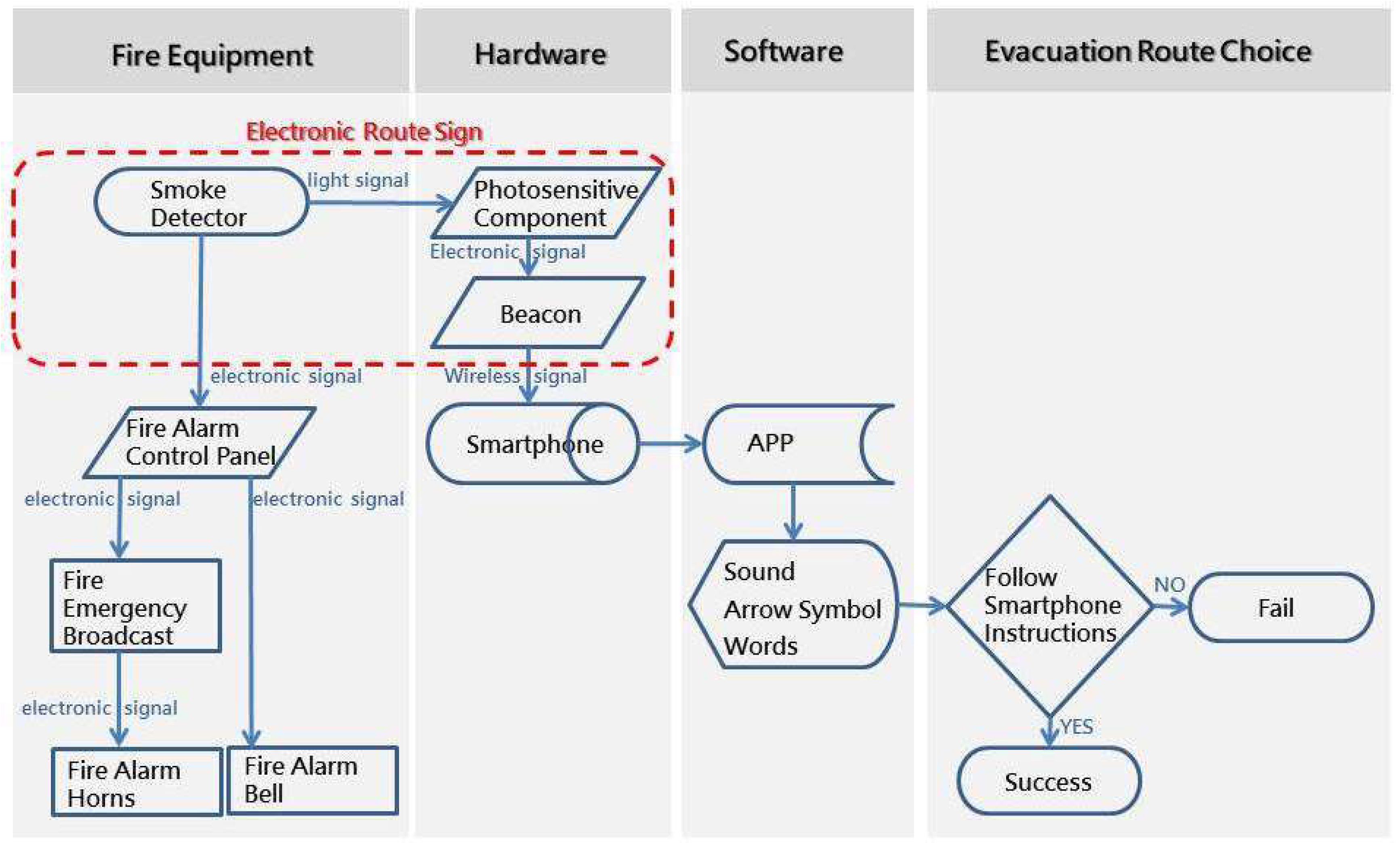
2.1. SVGES
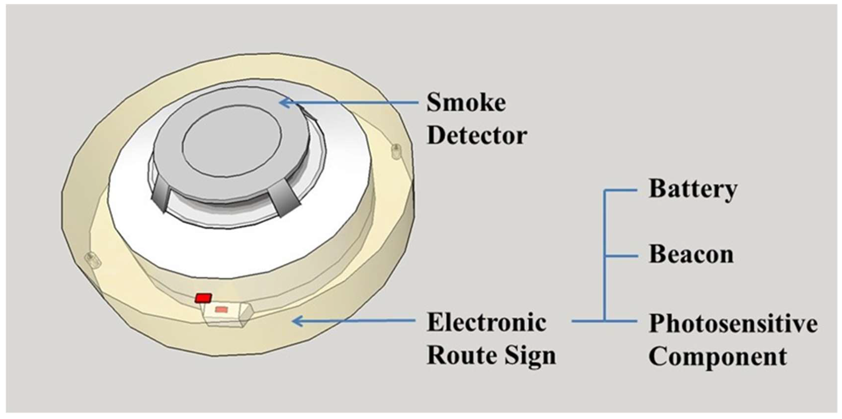
- Smartphone;
- Smoke detectors;
- ERSs
- (a)
- Battery;
- (b)
- Two beacons;
- (c)
- Photosensitive components;
- Smartphone app.
2.1.1. ERS
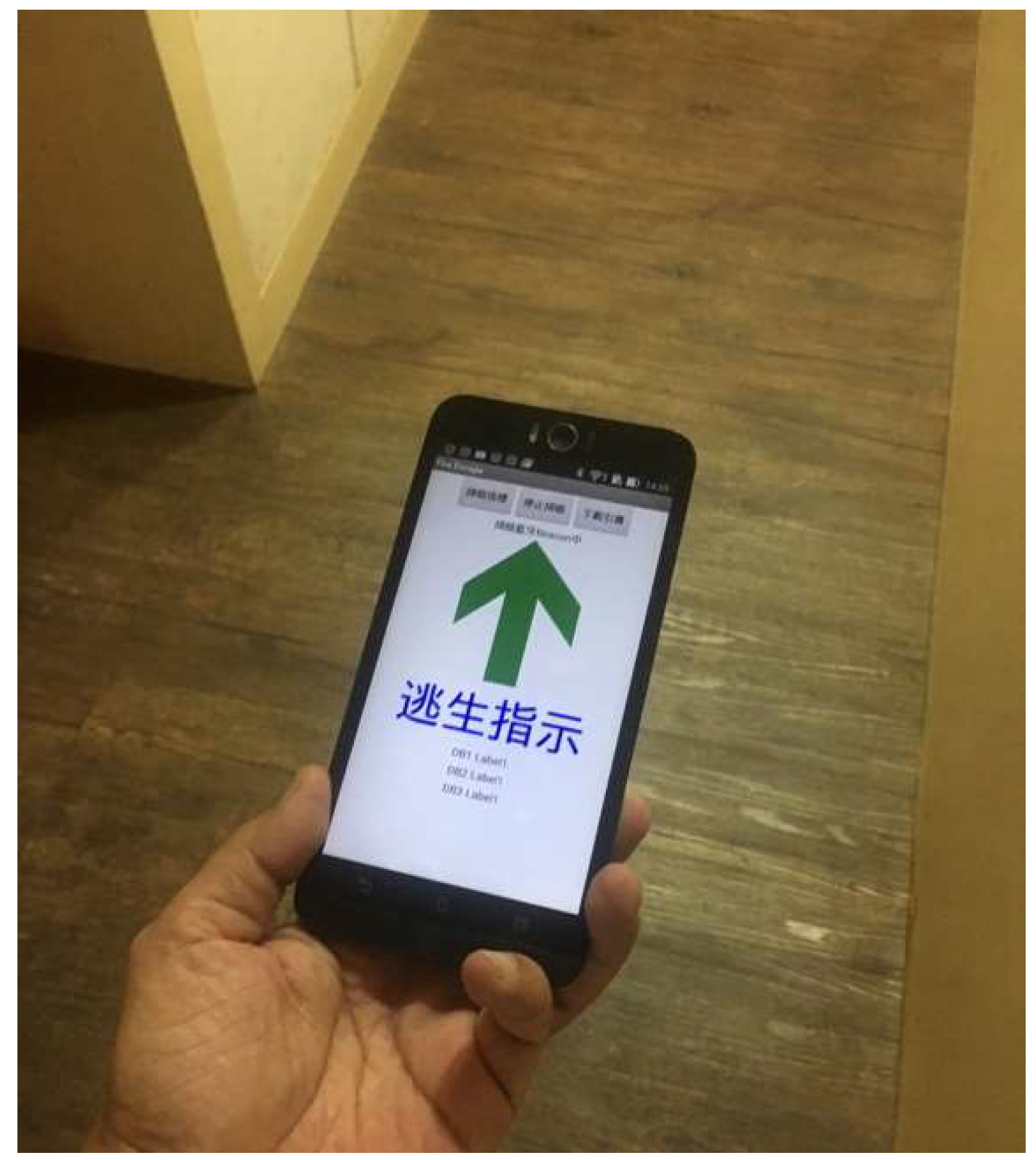
2.1.2. Smartphone App
2.2. Participants of the Experiment
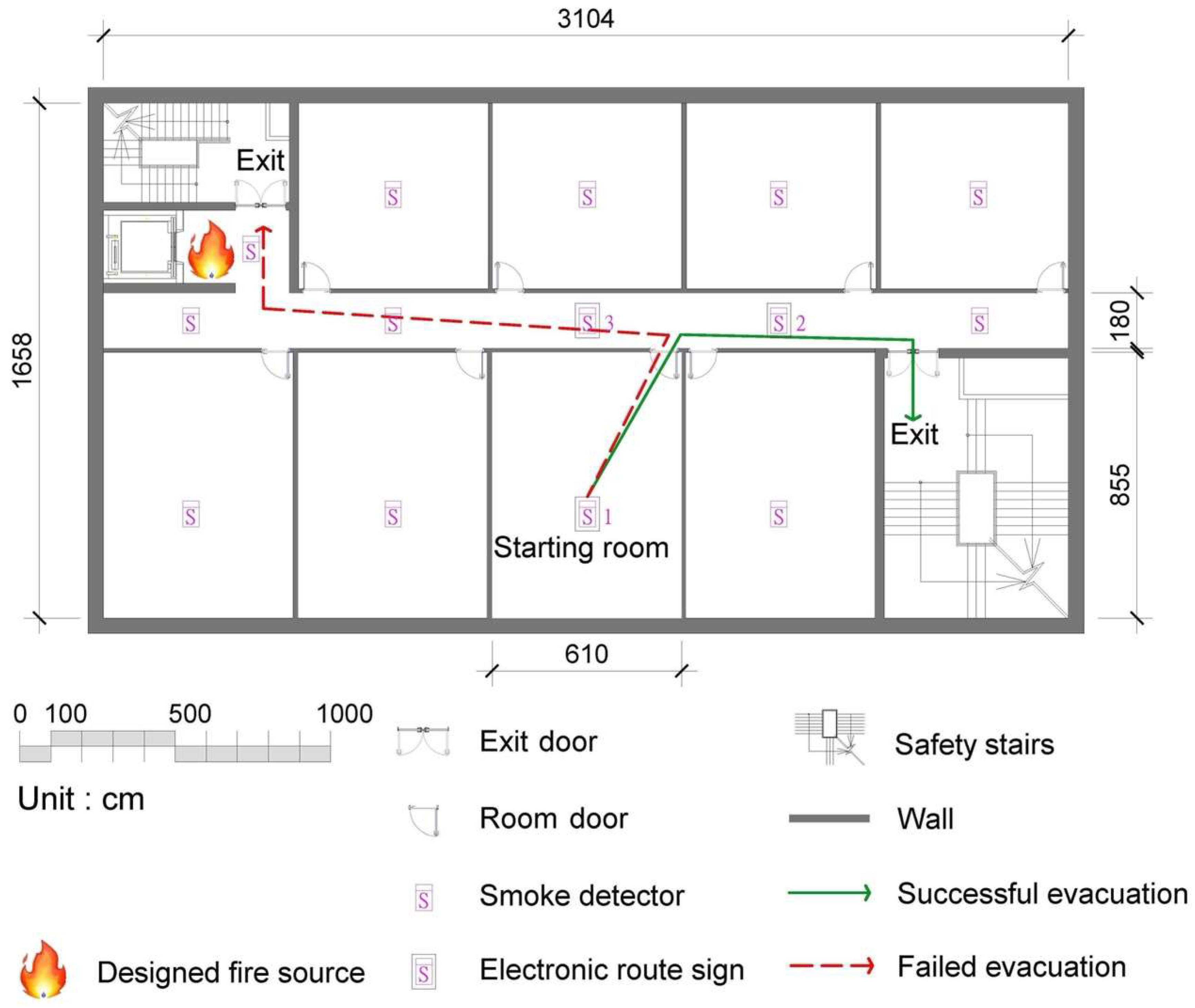
2.3. Experimental Environment
2.4. Experimental Procedure
3. Results and Discussion
4. Conclusions
Author Contributions
Funding
Institutional Review Board Statement
Informed Consent Statement
Data Availability Statement
Conflicts of Interest
References
- Fu, M.; Liu, R.; Zhang, Y. Why do people make risky decisions during a fire evacuation? Study on the effect of smoke level, individual risk preference, and neighbor behavior. Saf. Sci. 2021, 140, 105245. [Google Scholar] [CrossRef]
- Chen, J.; Shi, T.; Li, N. Pedestrian evacuation simulation in indoor emergency situations: Approaches, models and tools. Saf. Sci. 2021, 142, 105378. [Google Scholar] [CrossRef]
- Balboa, A.; Javier, G.-V.; Cuesta, A.; Abreu, O.; Alvear, D. Testing a real-time intelligent evacuation guiding system for complex buildings. Saf. Sci. 2020, 132, 104970. [Google Scholar] [CrossRef]
- Cho, J.; Lee, G.; Lee, S. An automated direction setting algorithm for a smart exit sign. Autom. Constr. 2015, 59, 139–148. [Google Scholar] [CrossRef]
- Filippidis, L.; Xie, H.; Galea, E.R.; Lawrence, P.J. Exploring the potential effectiveness of dynamic and static emergency exit signage in complex spaces through simulation. Fire Saf. J. 2021, 125, 103404. [Google Scholar] [CrossRef]
- Galea, E.; Xie, H.; Deere, S.; Cooney, D.; Filippidis, L. Evaluating the effectiveness of an improved active dynamic signage system using full scale evacuation trials. Fire Saf. J. 2017, 91, 908–917. [Google Scholar] [CrossRef]
- Galea, E.; Xie, H.; Lawrence, P.J. Experimental and Survey Studies on the Effectiveness of Dynamic Signage Systems. Fire Saf. Sci. 2014, 11, 1129–1143. [Google Scholar] [CrossRef] [Green Version]
- Ran, H.; Sun, L.; Gao, X. Influences of intelligent evacuation guidance system on crowd evacuation in building fire. Autom. Constr. 2014, 41, 78–82. [Google Scholar] [CrossRef]
- Zhao, H.; Schwabe, A.; Schläfli, F.; Thrash, T.; Aguilar, L.; Dubey, R.K.; Karjalainen, J.; Hölscher, C.; Helbing, D.; Schinazi, V.R. Fire evacuation supported by centralized and decentralized visual guidance systems. Saf. Sci. 2021, 145, 105451. [Google Scholar] [CrossRef]
- Kubota, J.; Sano, T.; Ronchi, E. Assessing the compliance with the direction indicated by emergency evacuation signage. Saf. Sci. 2021, 138, 105210. [Google Scholar] [CrossRef]
- Hsiao, G.L.-K.; Tang, C.-H.; Huang, T.-C.; Lin, C.-Y. Firefighter Wayfinding in Dark Environments Monitored by RFID. Fire Technol. 2015, 52, 273–279. [Google Scholar] [CrossRef]
- Kobes, M.; Helsloot, I.; de Vries, B.; Post, J.G. Building safety and human behaviour in fire: A literature review. Fire Saf. J. 2010, 45, 1–11. [Google Scholar] [CrossRef]
- Lin, B.S.-M.; Lin, C.-Y.; Kung, C.-W.; Lin, Y.-J.; Chou, C.-C.; Chuang, Y.-J.; Hsiao, G.L.-K. Wayfinding of Firefighters in Dark and Complex Environments. Int. J. Environ. Res. Public Health 2021, 18, 8014. [Google Scholar] [CrossRef] [PubMed]
- Fridolf, K.; Nilsson, D.; Frantzich, H. Fire Evacuation in Underground Transportation Systems: A Review of Accidents and Empirical Research. Fire Technol. 2011, 49, 451–475. [Google Scholar] [CrossRef]
- Li, N.; Becerik-Gerber, B.; Krishnamachari, B.; Soibelman, L. A BIM centered indoor localization algorithm to support building fire emergency response operations. Autom. Constr. 2014, 42, 78–89. [Google Scholar] [CrossRef]
- Wong, M.O.; Zhou, H.; Ying, H.; Lee, S. A voice-driven IMU-enabled BIM-based multi-user system for indoor navigation in fire emergencies. Autom. Constr. 2022, 135, 104137. [Google Scholar] [CrossRef]
- Chan, A.H.; Ng, A.W. Perceptions of implied hazard for visual and auditory alerting signals. Saf. Sci. 2009, 47, 346–352. [Google Scholar] [CrossRef]
- Rehman, I.U.; Sobnath, D.; Nasralla, M.M.; Winnett, M.; Anwar, A.; Asif, W.; Sherazi, H.H.R. Features of Mobile Apps for People with Autism in a Post COVID-19 Scenario: Current Status and Recommendations for Apps Using AI. Diagnostics 2021, 11, 1923. [Google Scholar] [CrossRef]
- Gao, B.; Chen, Z.; Chen, X.; Tu, H.; Huang, F. The effects of audiovisual landmarks on spatial learning and recalling for image browsing interface in virtual environments. J. Syst. Arch. 2021, 117, 102096. [Google Scholar] [CrossRef]
- Chou, J.-S.; Cheng, M.-Y.; Hsieh, Y.-M.; Yang, I.-T.; Hsu, H.-T. Optimal path planning in real time for dynamic building fire rescue operations using wireless sensors and visual guidance. Autom. Constr. 2018, 99, 1–17. [Google Scholar] [CrossRef]
- Cheng, M.-Y.; Chiu, K.-C.; Hsieh, Y.-M.; Yang, I.-T.; Chou, J.-S.; Wu, Y.-W. BIM integrated smart monitoring technique for building fire prevention and disaster relief. Autom. Constr. 2017, 84, 14–30. [Google Scholar] [CrossRef]
- Tang, C.-H.; Lin, C.-Y.; Hsu, Y.-M. Exploratory research on reading cognition and escape-route planning using building evacuation plan diagrams. Appl. Ergon. 2008, 39, 209–217. [Google Scholar] [CrossRef] [PubMed]
- Michel, T.; Genevès, P.; Fourati, H.; Layaïda, N. Attitude estimation for indoor navigation and augmented reality with smartphones. Pervasive Mob. Comput. 2018, 46, 96–121. [Google Scholar] [CrossRef] [Green Version]
- Murata, M.; Ahmetovic, D.; Sato, D.; Takagi, H.; Kitani, K.M.; Asakawa, C. Smartphone-based localization for blind navigation in building-scale indoor environments. Pervasive Mob. Comput. 2019, 57, 14–32. [Google Scholar] [CrossRef] [Green Version]
- Diao, P.-H.; Shih, N.-J. MARINS: A Mobile Smartphone AR System for Pathfinding in a Dark Environment. Sensors 2018, 18, 3442. [Google Scholar] [CrossRef] [Green Version]
- Zhang, J.; Guo, J.; Xiong, H.; Liu, X.; Zhang, D. A Framework for an Intelligent and Personalized Fire Evacuation Management System. Sensors 2019, 19, 3128. [Google Scholar] [CrossRef] [Green Version]
- Jin, B.; Wang, J.; Wang, Y.; Gu, Y.; Wang, Z. Temporal and spatial distribution of pedestrians in subway evacuation under node failure by multi-hazards. Saf. Sci. 2020, 127, 104695. [Google Scholar] [CrossRef]
- Danial, S.N.; Smith, J.; Khan, F.; Veitch, B. Human-Like Sequential Learning of Escape Routes for Virtual Reality Agents. Fire Technol. 2019, 55, 1057–1083. [Google Scholar] [CrossRef]
- Peacock, R.; Hoskins, B.; Kuligowski, E. Overall and local movement speeds during fire drill evacuations in buildings up to 31 stories. Saf. Sci. 2012, 50, 1655–1664. [Google Scholar] [CrossRef]
- Tavares, R.M.; Galea, E. Evacuation modelling analysis within the operational research context: A combined approach for improving enclosure designs. Build. Environ. 2009, 44, 1005–1016. [Google Scholar] [CrossRef]
- Ding, N.; Sun, C. Experimental study of leader-and-follower behaviours during emergency evacuation. Fire Saf. J. 2020, 117, 103189. [Google Scholar] [CrossRef]
- Xie, W.; Lee, E.W.-M.; Lee, Y.-Y. Simulation of spontaneous leader-follower behaviour in crowd evacuation. Autom. Constr. 2022, 134, 104100. [Google Scholar] [CrossRef]
- Zhu, R.; Lin, J.; Becerik-Gerber, B.; Li, N. Human-building-emergency interactions and their impact on emergency response performance: A review of the state of the art. Saf. Sci. 2020, 127, 104691. [Google Scholar] [CrossRef]
- Hadjisophocleous, G.V.; Mehaffey, J.R. SFPE Handbook of Fire Protection Engineering, 5th ed.; Chapter 38 Fire Scenarios; National Fire Protection Association: Greenbelt, MD, USA, 2016. [Google Scholar]
- Tinaburri, A. Principles for Monte Carlo agent-based evacuation simulations including occupants who need assistance. From RSET to RiSET. Fire Saf. J. 2021, 127, 103510. [Google Scholar] [CrossRef]


Publisher’s Note: MDPI stays neutral with regard to jurisdictional claims in published maps and institutional affiliations. |
© 2022 by the authors. Licensee MDPI, Basel, Switzerland. This article is an open access article distributed under the terms and conditions of the Creative Commons Attribution (CC BY) license (https://creativecommons.org/licenses/by/4.0/).
Share and Cite
Kuo, T.-W.; Lin, C.-Y.; Chuang, Y.-J.; Hsiao, G.L.-K. Using Smartphones for Indoor Fire Evacuation. Int. J. Environ. Res. Public Health 2022, 19, 6061. https://doi.org/10.3390/ijerph19106061
Kuo T-W, Lin C-Y, Chuang Y-J, Hsiao GL-K. Using Smartphones for Indoor Fire Evacuation. International Journal of Environmental Research and Public Health. 2022; 19(10):6061. https://doi.org/10.3390/ijerph19106061
Chicago/Turabian StyleKuo, Tzu-Wen, Ching-Yuan Lin, Ying-Ji Chuang, and Gary Li-Kai Hsiao. 2022. "Using Smartphones for Indoor Fire Evacuation" International Journal of Environmental Research and Public Health 19, no. 10: 6061. https://doi.org/10.3390/ijerph19106061
APA StyleKuo, T.-W., Lin, C.-Y., Chuang, Y.-J., & Hsiao, G. L.-K. (2022). Using Smartphones for Indoor Fire Evacuation. International Journal of Environmental Research and Public Health, 19(10), 6061. https://doi.org/10.3390/ijerph19106061