
Issues in the Current Practices of Spatial Cluster Detection and Exploring Alternative Methods


Abstract
:1. Introduction
2. Spatial Cluster Detection
2.1. What Are Spatial Clusters?
2.2. Current Practices of Spatial Cluster Detection
3. Limitations of Using Local SA Statistics for HSCS Detection
3.1. Nature of Local SA Statistics
3.2. Nature of Statistical Estimates
4. Alternatives to Existing Hot Spot and Cold Spot Detection Tools
4.1. Class Separability Classification as a HSCS Detection Tool
4.2. Heuristic HSCS Identification Method
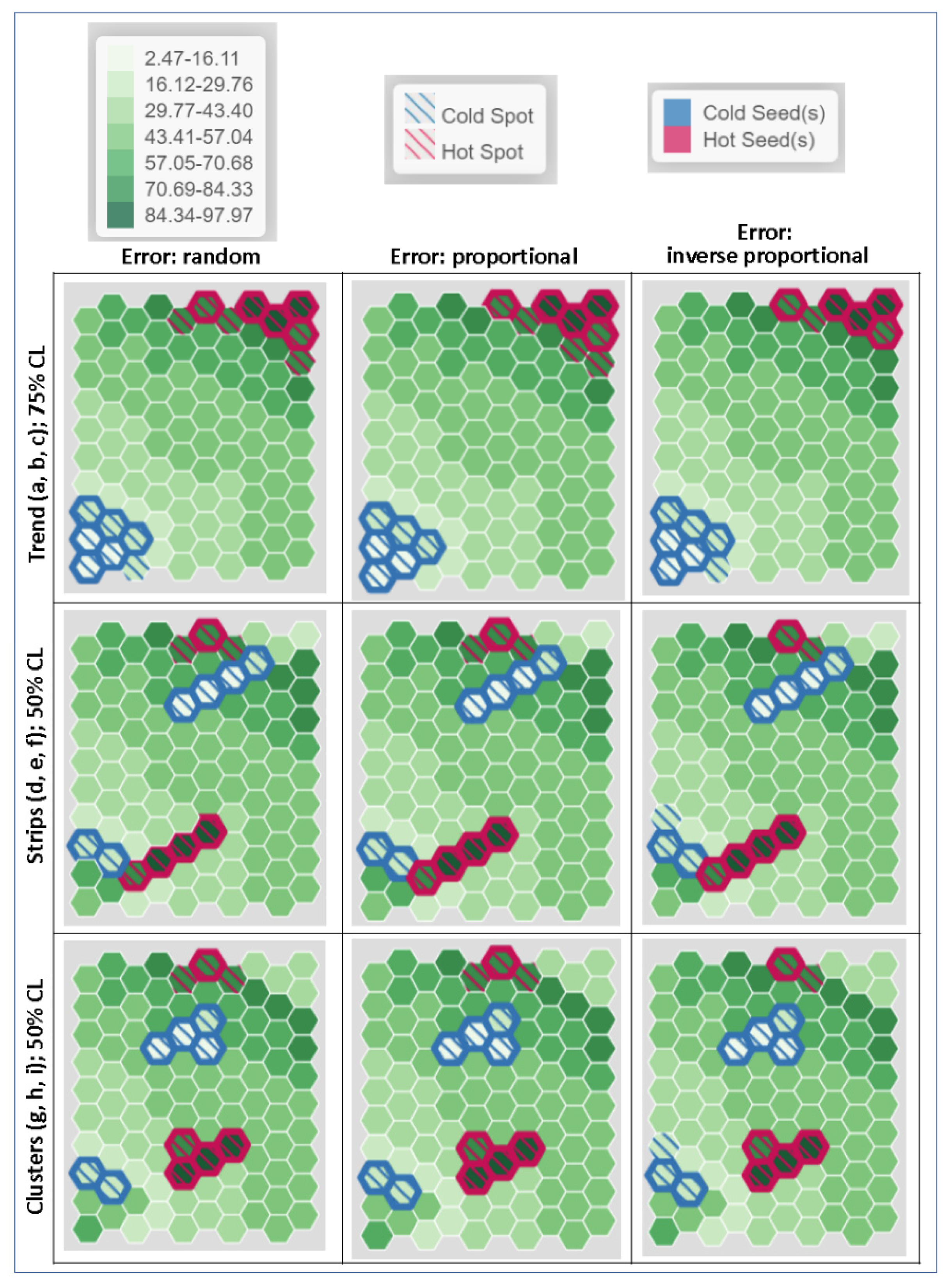
5. Heuristic HSCS Detection in Action
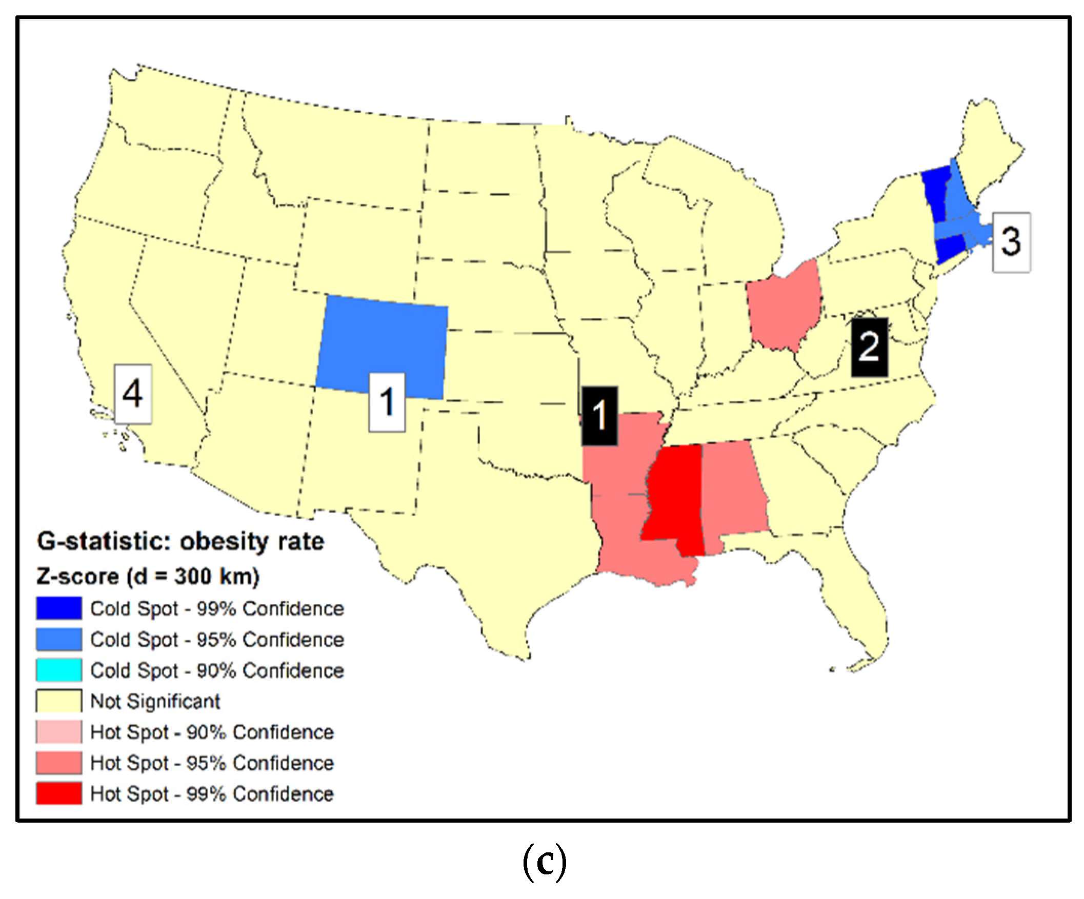
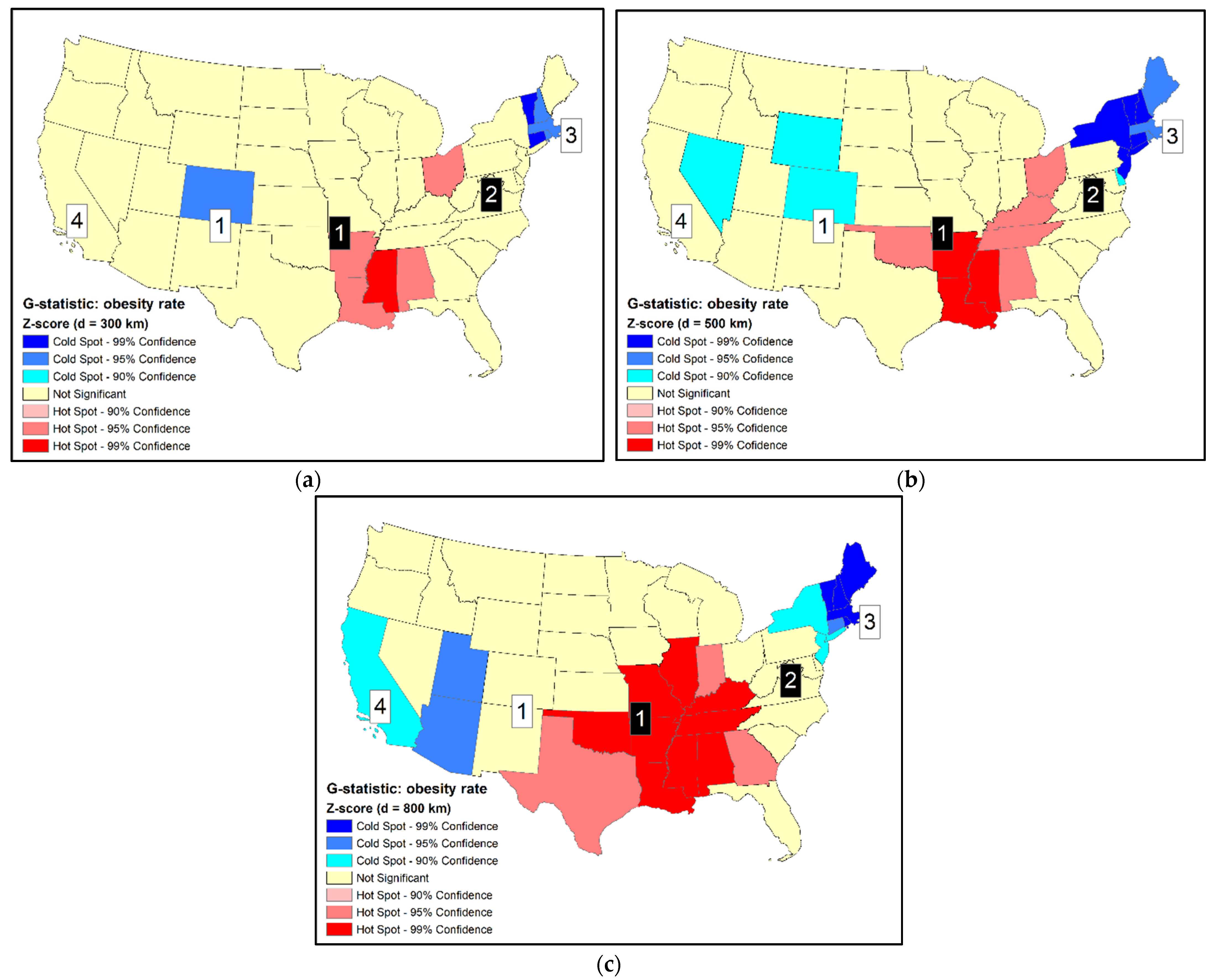
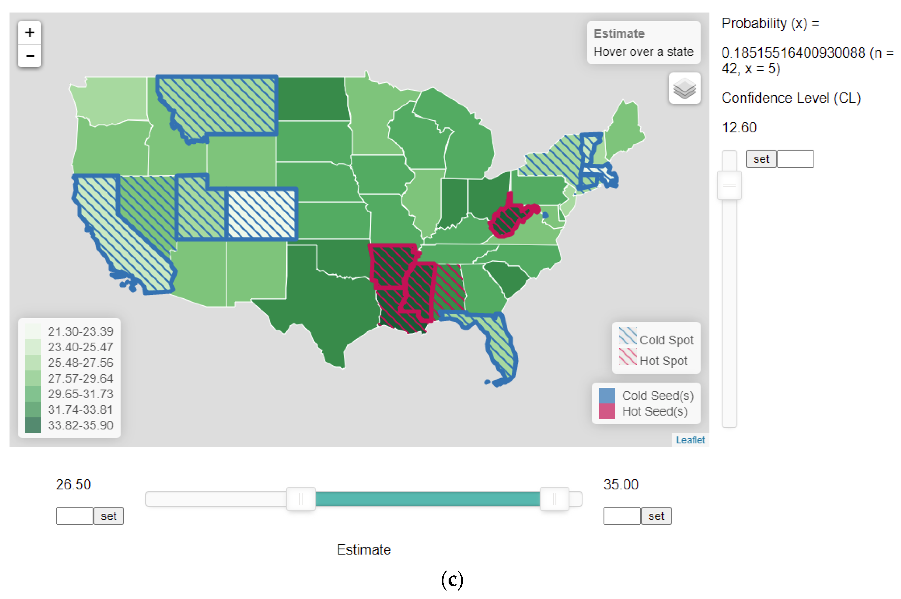
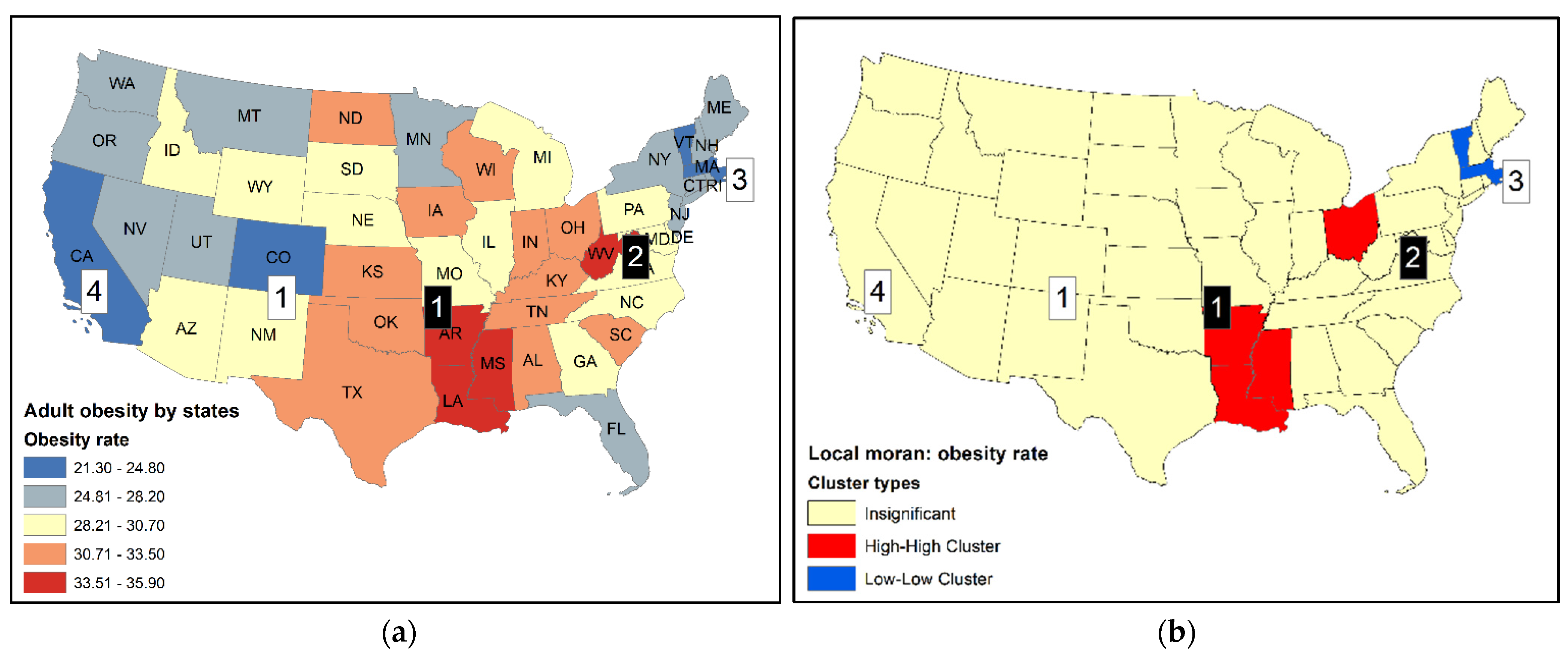
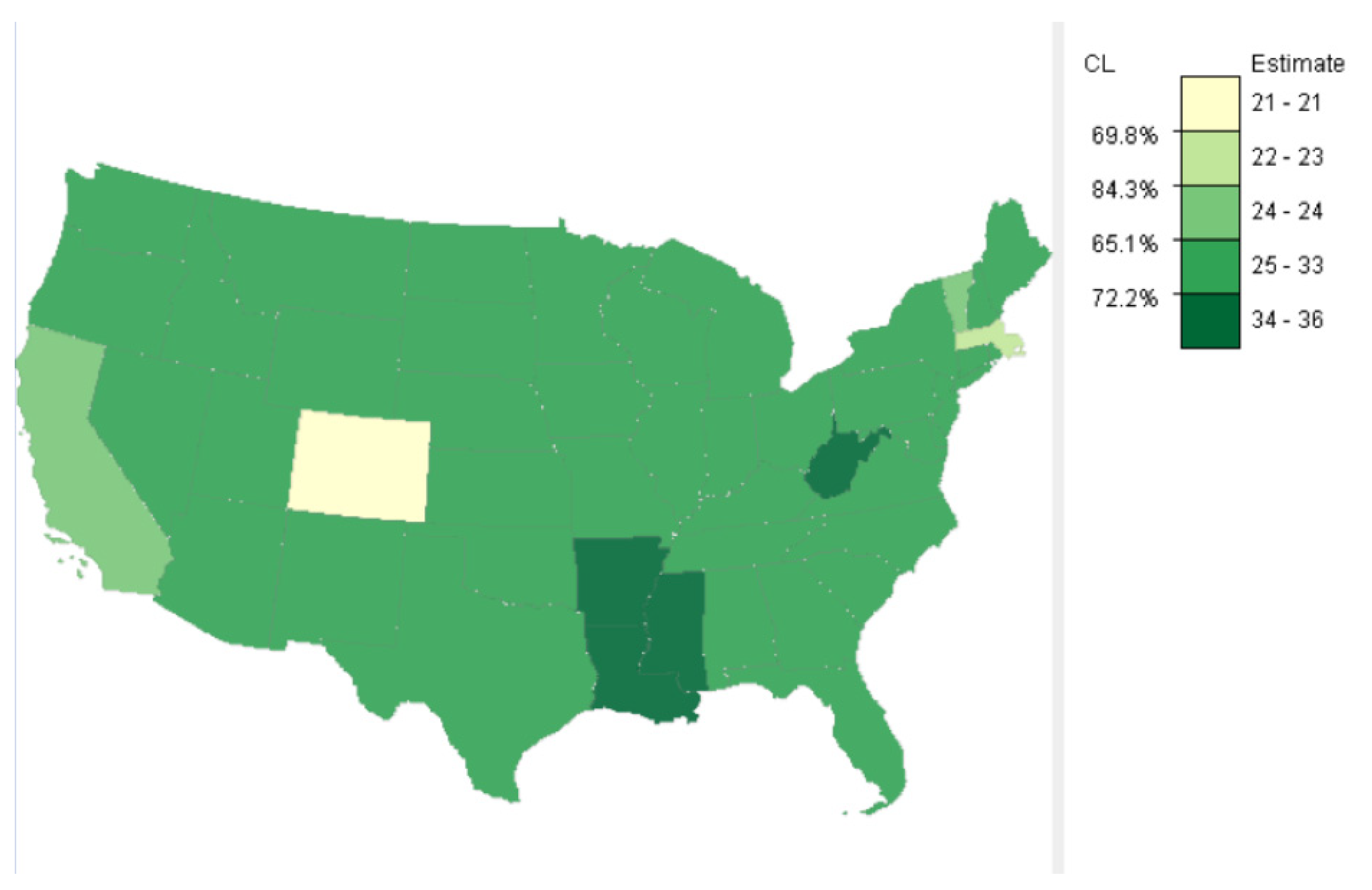
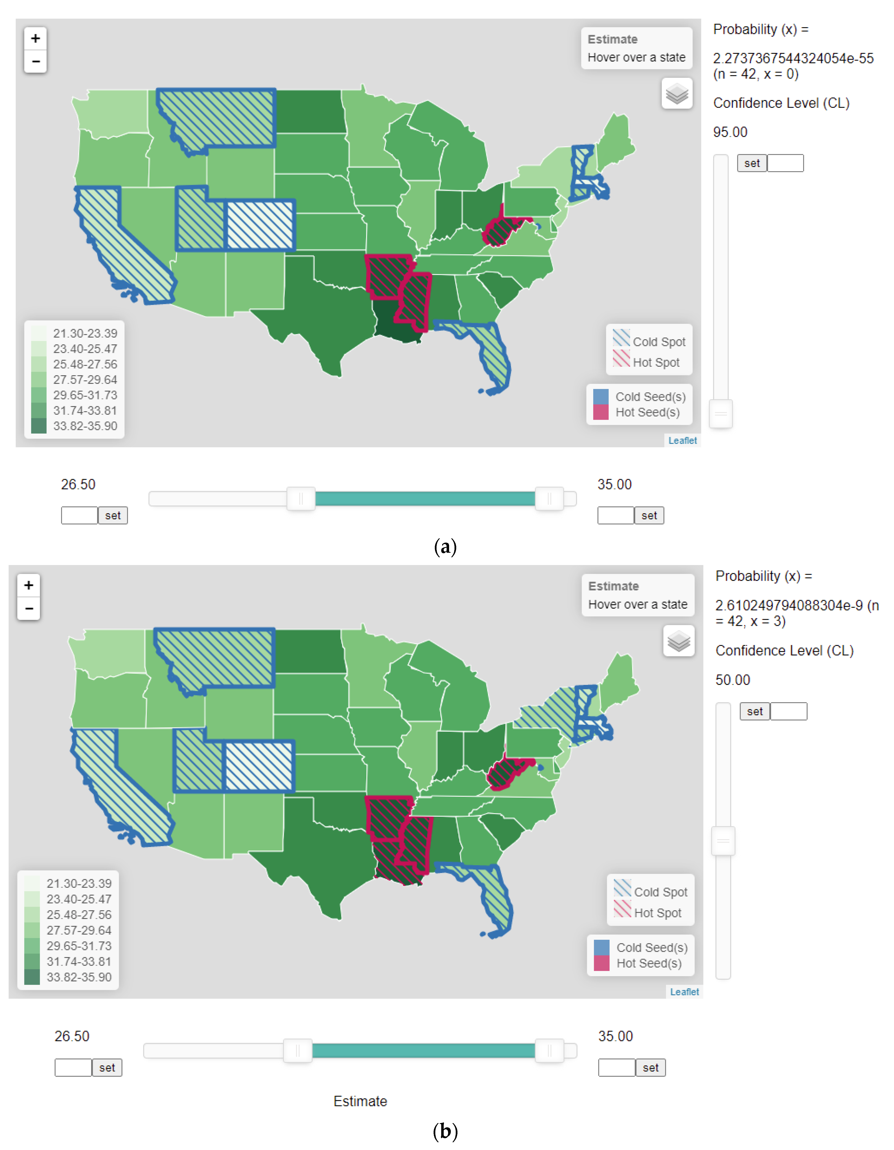
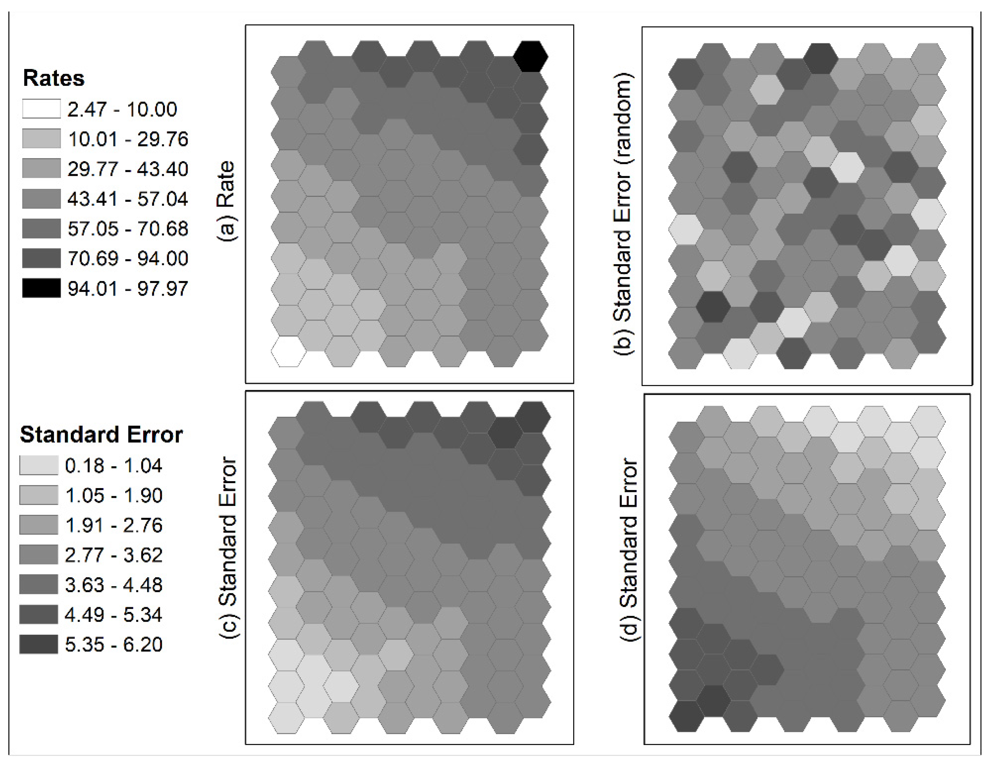
5.1. An Empirical Example
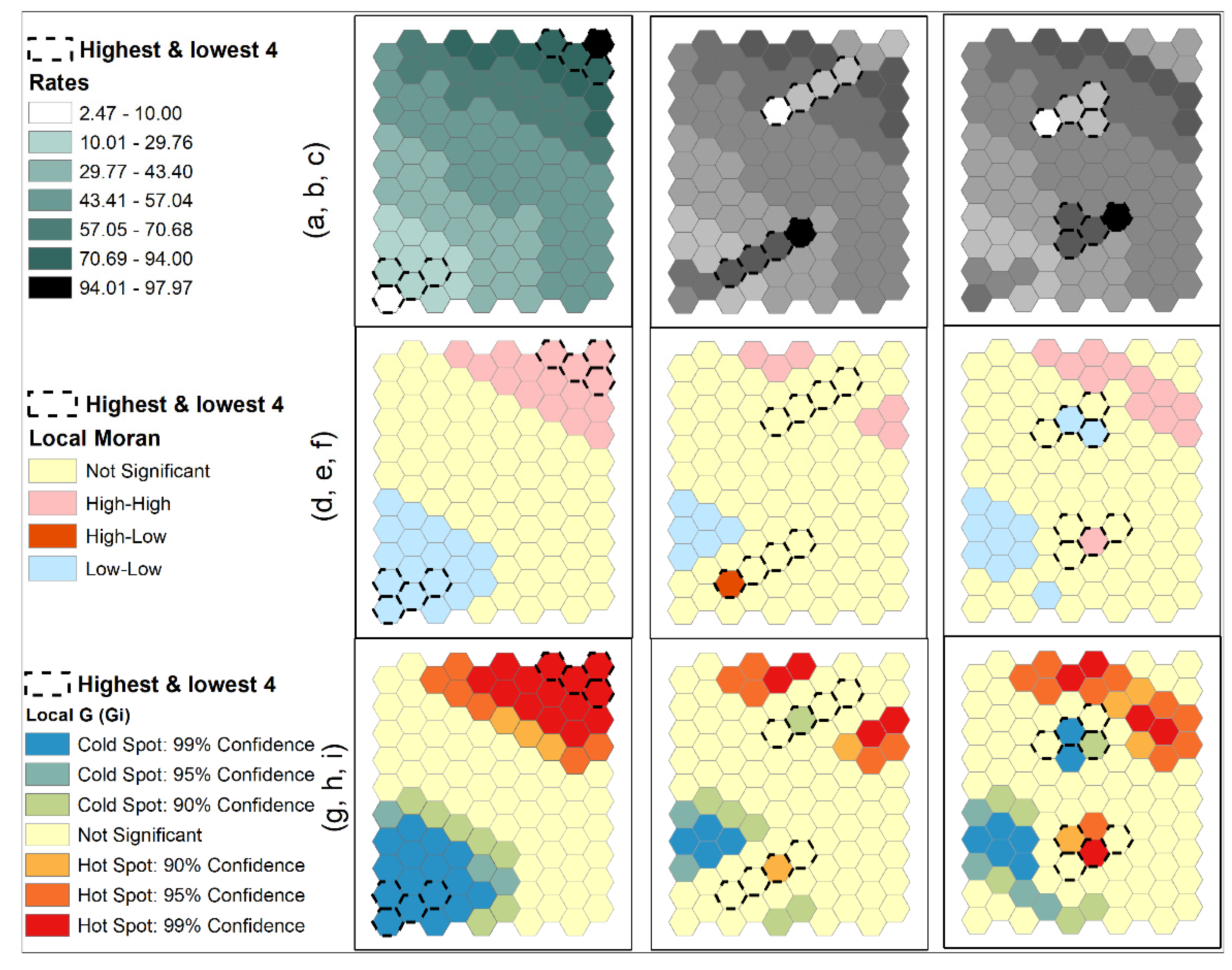
5.2. Simulated Data
6. Conclusions
Funding
Institutional Review Board Statement
Informed Consent Statement
Data Availability Statement
Acknowledgments
Conflicts of Interest
References
- Burra, T.; Jerrett, M.; Burnett, R.T.; Anderson, M. Conceptual and Practical Issues in the Detection of Local Disease Clusters: A Study of Mortality in Hamilton, Ontario. Can. Geogr. Le Géographe Can. 2002, 46, 160–171. [Google Scholar] [CrossRef]
- Cromley, E.K.; McLafferty, S.L. GIS and Public Health, 2nd ed.; Guilford Press: New York, NY, USA, 2011. [Google Scholar]
- Waller, L.A.; Gotway, C.A. Applied Spatial Statistics for Public Health Data; John Wiley & Sons: Hoboken, NJ, USA, 2004. [Google Scholar]
- Andresen, M.A. Estimating the Probability of Local Crime Clusters: The Impact of Immediate Spatial Neighbors. J. Crim. Justice 2011, 39, 394–404. [Google Scholar] [CrossRef]
- Levine, N. Crime Mapping and the Crimestat Program. Geogr. Anal. 2006, 38, 41–56. [Google Scholar] [CrossRef]
- Messner, S.F.; Anselin, L.; Baller, R.D.; Hawkins, D.F.; Deane, G.; Tolnay, S.E. The Spatial Patterning of County Homicide Rates: An Application of Exploratory Spatial Data Analysis. J. Quant. Criminol. 1999, 15, 423–450. [Google Scholar] [CrossRef]
- Zhang, C.; Luo, L.; Xu, W.; Ledwith, V. Use of Local Moran’s I and GIS to Identify Pollution Hotspots of Pb in Urban Soils of Galway, Ireland. Sci. Total. Environ. 2008, 398, 212–221. [Google Scholar] [CrossRef] [PubMed]
- Zou, B.; Peng, F.; Wan, N.; Mamady, K.; Wilson, G.J. Spatial Cluster Detection of Air Pollution Exposure Inequities across the United States. PLoS ONE 2014, 9, e91917. [Google Scholar] [CrossRef] [PubMed] [Green Version]
- Dall’erba, S. Distribution of Regional Income and Regional Funds in Europe 1989–1999: An Exploratory Spatial Data Analysis. Ann. Reg. Sci. 2005, 39, 121–148. [Google Scholar] [CrossRef] [Green Version]
- Le Gallo, J.; Ertur, C. Exploratory Spatial Data Analysis of the Distribution of Regional per Capita GDP in Europe, 1980–1995. Pap. Reg. Sci. 2003, 82, 175–201. [Google Scholar] [CrossRef] [Green Version]
- Anselin, L. Local Indicators of Spatial Association—LISA. Geogr. Anal. 1995, 27, 93–115. [Google Scholar] [CrossRef]
- Getis, A.; Ord, J.K. The Analysis of Spatial Association by Use of Distance Statistics. Geogr. Anal. 1992, 24, 189–206. [Google Scholar] [CrossRef]
- Cliff, A.D.; Ord, J.K. Spatial Autocorrelation; Pion: London, UK, 1973. [Google Scholar]
- Spielman, S.E.; Folch, D.; Nagle, N. Patterns and Causes of Uncertainty in the American Community Survey. Appl. Geogr. 2014, 46, 147–157. [Google Scholar] [CrossRef] [PubMed] [Green Version]
- Koo, H.; Wong, D.W.S.; Chun, Y. Measuring Global Spatial Autocorrelation with Data Reliability Information. Prof. Geogr. 2019, 71, 551–565. [Google Scholar] [CrossRef] [PubMed]
- Wheeler, D.C. A Comparison of Spatial Clustering and Cluster Detection Techniques for Childhood Leukemia Incidence in Ohio, 1996–2003. Int. J. Health Geogr. 2007, 6, 13. [Google Scholar] [CrossRef] [PubMed] [Green Version]
- Kulldorff, M. A Spatial Scan Statistic. Commun. Stat. Theory Methods 1997, 26, 1481–1496. [Google Scholar] [CrossRef]
- Jacquez, G.M. Spatial Cluster Analyisis. In The Handbook of Geographic Information Science; Wilson, J.P., Fotheringham, A.S., Eds.; John Wiley & Sons: Hoboken, NJ, USA, 2008; pp. 395–415. [Google Scholar]
- Levi, J.; Segal, L.M.; Martin, A.; Rayburn, J. The State of Obesity: Better Policies for a Healthier America 2015; Trust for America’s Health, Robert Wood Johnson Foundation: Princeton, NJ, USA, 2015. [Google Scholar]
- Nelson, T.A.; Boots, B. Detecting Spatial Hot Spots in Landscape Ecology. Ecography 2008, 31, 556–566. [Google Scholar] [CrossRef]
- Amarasinghe, A.; D’Souza, G.; Brown, C.; Oh, H.; Borisova, T. The Influence of Socioeconomic and Environmental Determinants on Health and Obesity: A West Virginia Case Study. Int. J. Environ. Res. Public Health 2009, 6, 2271–2287. [Google Scholar] [CrossRef] [PubMed] [Green Version]
- Baskin, M.L.; Ard, J.; Franklin, F.; Allison, D.B. Prevalence of Obesity in the United States. Obes. Rev. 2005, 6, 5–7. [Google Scholar] [CrossRef]
- Rye, J.A.; Rye, S.L.; Tessaro, I.; Coffindaffer, J. Perceived Barriers to Physical Activity According to Stage of Change and Body Mass Index in the West Virginia Wisewoman Population. Women’s Heal. Issues 2009, 19, 126–134. [Google Scholar] [CrossRef] [PubMed]
- Jung, P.H.; Thill, J.-C.; Issel, M. Spatial Autocorrelation and Data Uncertainty in the American Community Survey: A Critique. Int. J. Geogr. Inf. Sci. 2019, 33, 1155–1175. [Google Scholar] [CrossRef]
- Sun, M.; Wong, D.W.S. Incorporating Data Quality Information in Mapping American Community Survey Data. Cartogr. Geogr. Inf. Sci. 2010, 37, 285–299. [Google Scholar] [CrossRef]
- Aldstadt, J.; Getis, A. Using AMOEBA to Create a Spatial Weights Matrix and Identify Spatial Clusters. Geogr. Anal. 2006, 38, 327–343. [Google Scholar] [CrossRef]
- Coleman, M.; Coleman, M.; Mabuza, A.M.; Kok, G.; Coetzee, M.; Durrheim, D.N. Using the SaTScan Method to Detect Local Malaria Clusters for Guiding Malaria Control Programmes. Malar. J. 2009, 8, 68. [Google Scholar] [CrossRef] [PubMed] [Green Version]
- Jung, P.H.; Thill, J.-C.; Issel, M. Spatial Autocorrelation Statistics of Areal Prevalence Rates under High Uncertainty in Denominator Data. Geogr. Anal. 2019, 51, 354–380. [Google Scholar] [CrossRef]
- Stahl, P.; Vandel, J.M.; Herrenschmidt, V.; Migot, P. Predation on Livestock by an Expanding Reintroduced Lynx Population: Long-Term Trend and Spatial Variability. J. Appl. Ecol. 2001, 38, 674–687. [Google Scholar] [CrossRef] [Green Version]
- Sun, M.; Wong, D.W.; Kronenfeld, B.J. A Classification Method for Choropleth Maps Incorporating Data Reliability Information. Prof. Geogr. 2015, 67, 72–83. [Google Scholar] [CrossRef]
- Chaikaew, N.; Tripathi, N.K.; Souris, M. Exploring Spatial Patterns and Hotspots of Diarrhea in Chiang Mai, Thailand. Int. J. Heal. Geogr 2009, 8, 36. [Google Scholar] [CrossRef] [Green Version]
- Quick, M.; Law, J. Exploring Hotspots of Drug Offences in Toronto: A Comparison of Four Local Spatial Cluster Detection Methods. Can. J. Criminol. Crim. Justice 2013, 55, 215–238. [Google Scholar] [CrossRef]
- Chun, Y.; Griffith, D.A. Spatial Statistics and Geostatistics: Theory and Applications for Geographic Information Science and Technology; SAGE Publications Ltd.: Thousand Oaks, CA, USA, 2013. [Google Scholar]
- Koo, H.; Chun, Y.; Wong, D.W.S. Measuring Local Spatial Autocorrelation with Data Reliability Information. Prof. Geogr. 2021, 73, 464–480. [Google Scholar] [CrossRef]


| Top Rank | States | Obesity Rate | Bottom Rank | States | Obesity Rate |
|---|---|---|---|---|---|
| 1 | Arkansas (AR) | 35.90 | 1 | Colorado (CO) | 21.30 |
| 2 | West Virginia (WV) | 35.70 | 2 | District of Columbia (DC) | 21.70 |
| 3 | Mississippi (MS) | 35.50 | 3 | Massachusetts (MA) | 23.30 |
| 4 | Louisiana (LA) | 34.90 | 4 | California (CA) | 24.70 |
| 5 | Alabama (AL) | 33.50 | 5 | Vermont (VT) | 24.80 |
| 6 | Oklahoma (OK) | 33.00 | 6 | Utah (UT) | 25.70 |
| 7 | Indiana (IN) | 32.70 | 7 | Florida (FL) | 26.20 |
| 8 | Ohio (OH) | 32.60 | 8 | Connecticut (CT) | 26.30 |
| 9 | North Dakota (ND) | 32.30 | 9 | Montana (MT) | 26.40 |
| 10 | South Carolina (SC) | 32.10 | 10 | New Jersey (NJ) | 26.90 |
| 11 | Texas (TX) | 31.90 | 11 | New York (NY) | 27.00 |
| 12 | Kentucky (KY) | 31.60 | 12 | Rhode Island (RI) | 27.00 |
| Obesity Hot-Spot States | Alabama (AL) | Arkansas (AR) | Louisiana (LA) | Mississippi (MS) | |
| Arkansas (AR) | 0.07 * | ||||
| Louisiana (LA) | 0.20 | 0.45 | |||
| Mississippi (MS) | 0.13 | 0.79 | 0.65 | ||
| Florida (FL) | 0.01 * | ||||
| Georgia (GA) | 0.01 * | ||||
| Missouri (MO) | 0.01 * | ||||
| Oklahoma (OK) | 0.02 * | ||||
| Tennessee (TN) | 0.07 * | 0.01 * | 0.01 * | ||
| Texas (TX) | 0.01 * | 0.01 * | |||
| Obesity Cold-Spot States | Connecticut (CT) | Massachusetts (MA) | New Hampshire (NH) | Rhode Island (RI) | Vermont (VT) |
| Massachusetts (MA) | 0.01 * | 0.00 * | |||
| New Hampshire (NH) | 0.33 | 0.01 * | |||
| Rhode Island (RI) | 0.52 | 0.01 * | 0.86 | ||
| Vermont (VT) | 0.12 | 0.08 # | 0.02 * | 0.04 * | |
| Maine (ME) | 0.46 | ||||
| New York (NY) | 0.50 | 0.01 * | 0.03 * | ||
Publisher’s Note: MDPI stays neutral with regard to jurisdictional claims in published maps and institutional affiliations. |
© 2021 by the author. Licensee MDPI, Basel, Switzerland. This article is an open access article distributed under the terms and conditions of the Creative Commons Attribution (CC BY) license (https://creativecommons.org/licenses/by/4.0/).
Share and Cite
Wong, D.W.S. Issues in the Current Practices of Spatial Cluster Detection and Exploring Alternative Methods. Int. J. Environ. Res. Public Health 2021, 18, 9848. https://doi.org/10.3390/ijerph18189848
Wong DWS. Issues in the Current Practices of Spatial Cluster Detection and Exploring Alternative Methods. International Journal of Environmental Research and Public Health. 2021; 18(18):9848. https://doi.org/10.3390/ijerph18189848
Chicago/Turabian StyleWong, David W. S. 2021. "Issues in the Current Practices of Spatial Cluster Detection and Exploring Alternative Methods" International Journal of Environmental Research and Public Health 18, no. 18: 9848. https://doi.org/10.3390/ijerph18189848
APA StyleWong, D. W. S. (2021). Issues in the Current Practices of Spatial Cluster Detection and Exploring Alternative Methods. International Journal of Environmental Research and Public Health, 18(18), 9848. https://doi.org/10.3390/ijerph18189848