Assessing Spatial Accessibility to Hierarchical Urban Parks by Multi-Types of Travel Distance in Shenzhen, China


Abstract
1. Introduction
2. Materials and Methods
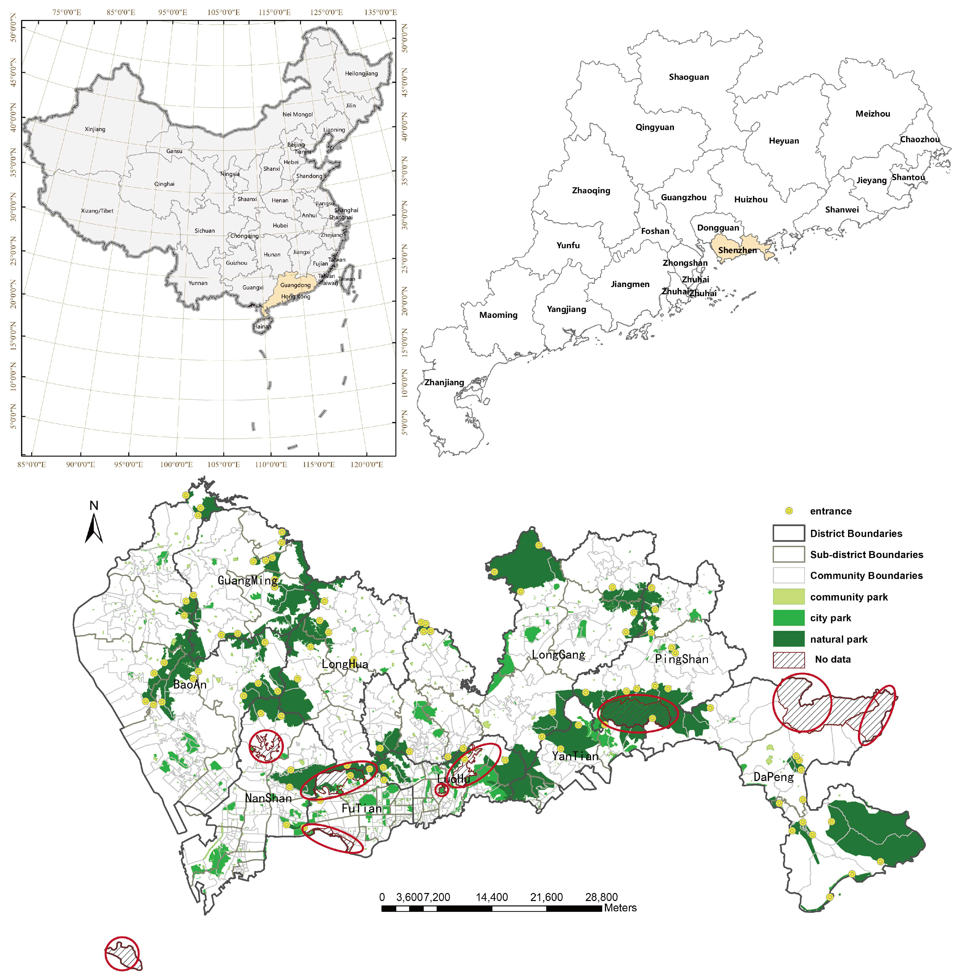
2.1. Study Area
2.2. Data Source and Preprocessing
2.3. Method
2.3.1. Modified Gaussian-Based 2SFCA
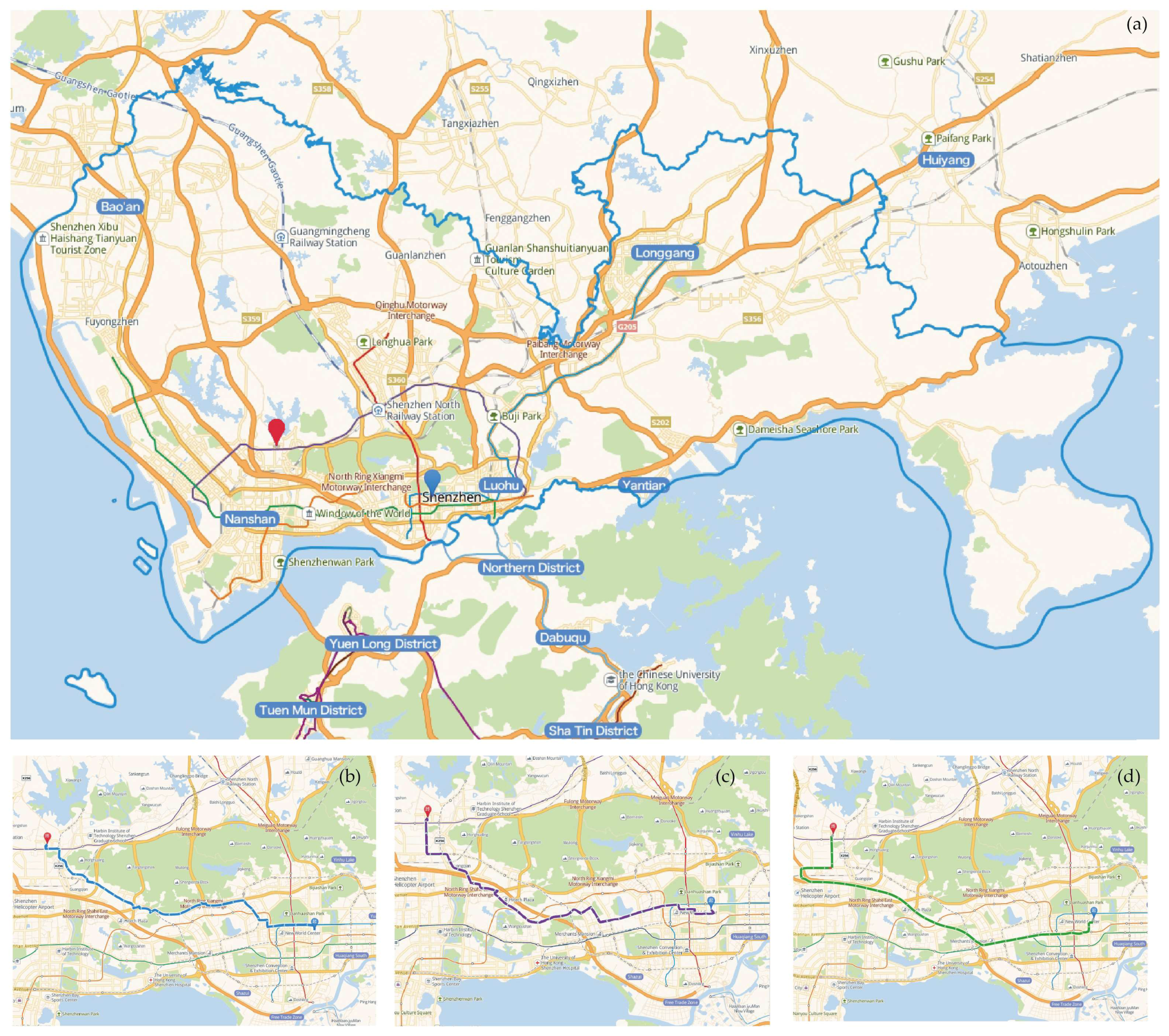
2.3.2. Estimation of Travel Distance
2.3.3. Parameters
2.3.4. Measurement of Spatial Disparity
- (1)
- If ZAi > 0 and ZPopDi > 0, community i has high accessibility and high population density.
- (2)
- If ZAi < 0 and ZPopDi < 0, community i has low accessibility and low population density.
- (3)
- If ZAi > 0 and ZPopDi < 0, community i has high accessibility and low population density.
- (4)
- If ZAi < 0 and ZPopDi > 0, community i has low accessibility and high population density.
3. Results
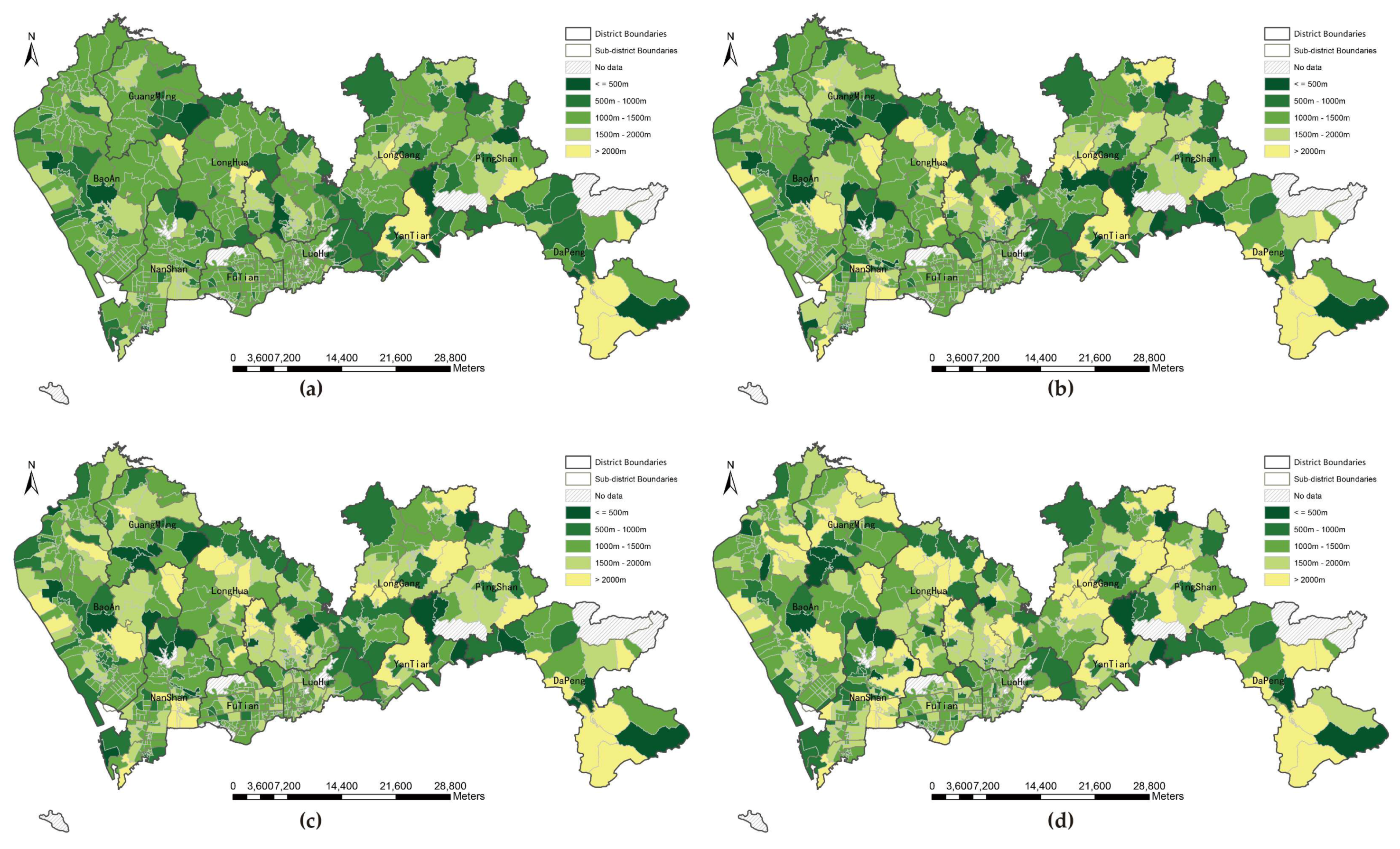
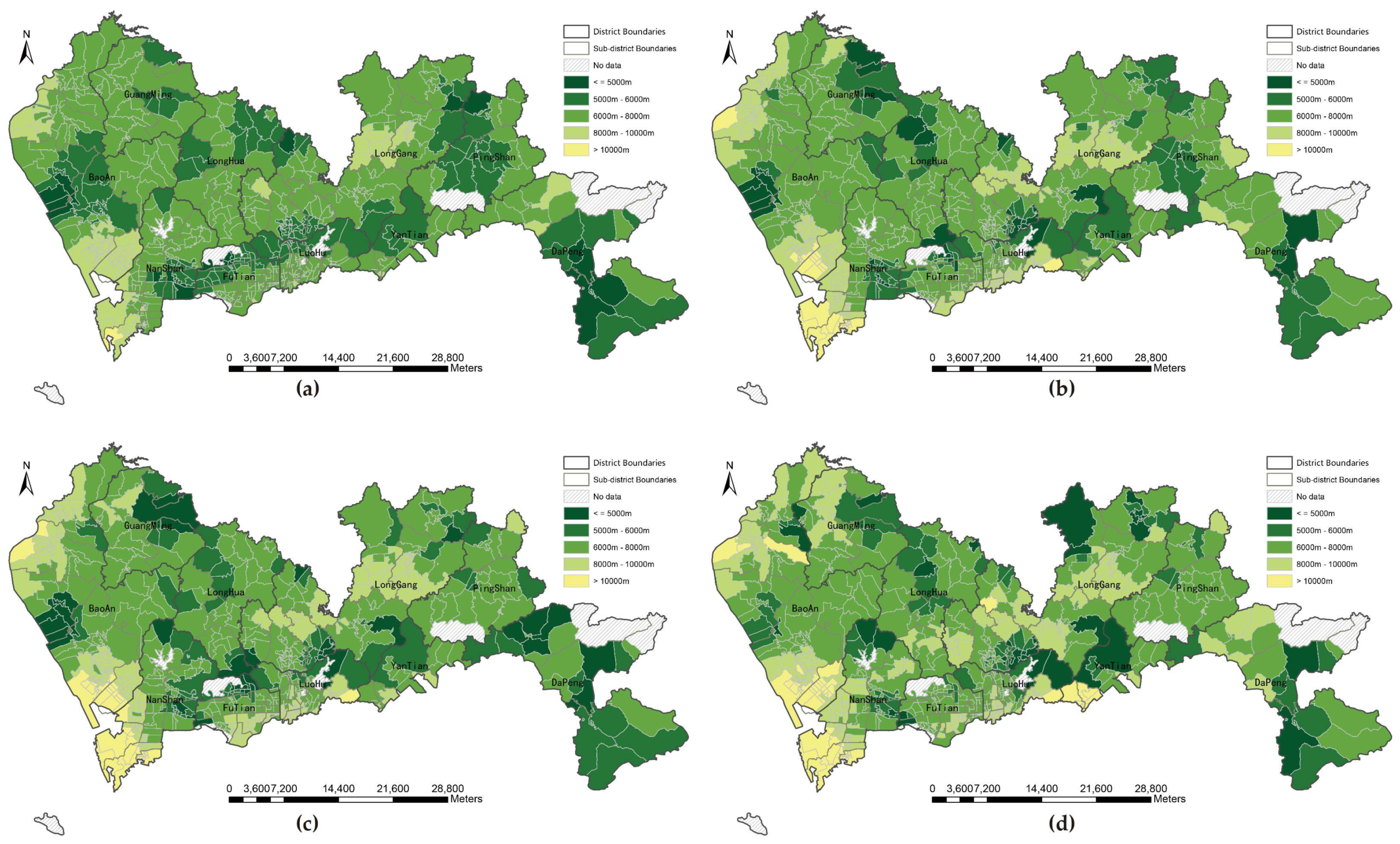
3.1. Proximity between Communities and Urban Parks under Four Types of Distance
3.1.1. Proximity without Distance Threshold
3.1.2. Proximity under Fixed Distance Threshold
3.2. Results of MG2SFCA at Three Levels of Parks
3.2.1. Statistical Analysis of Park Accessibility
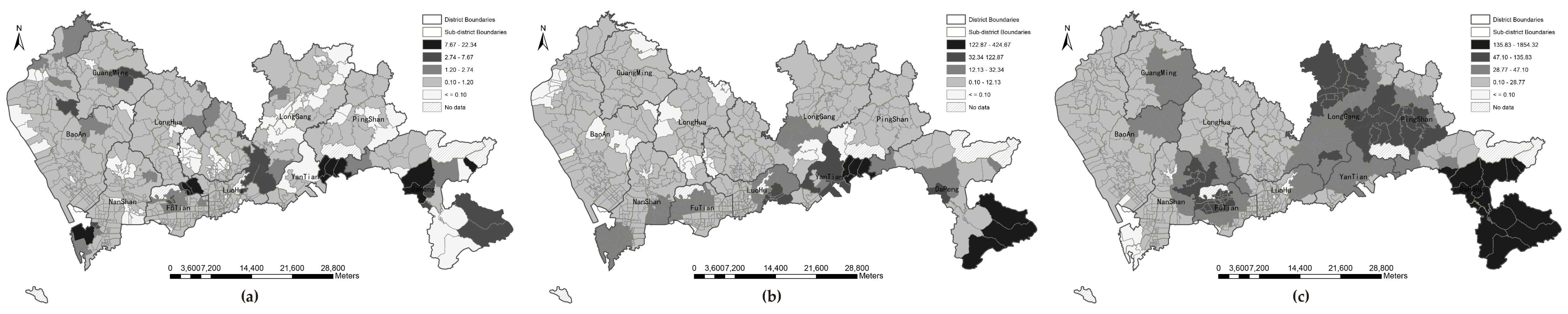
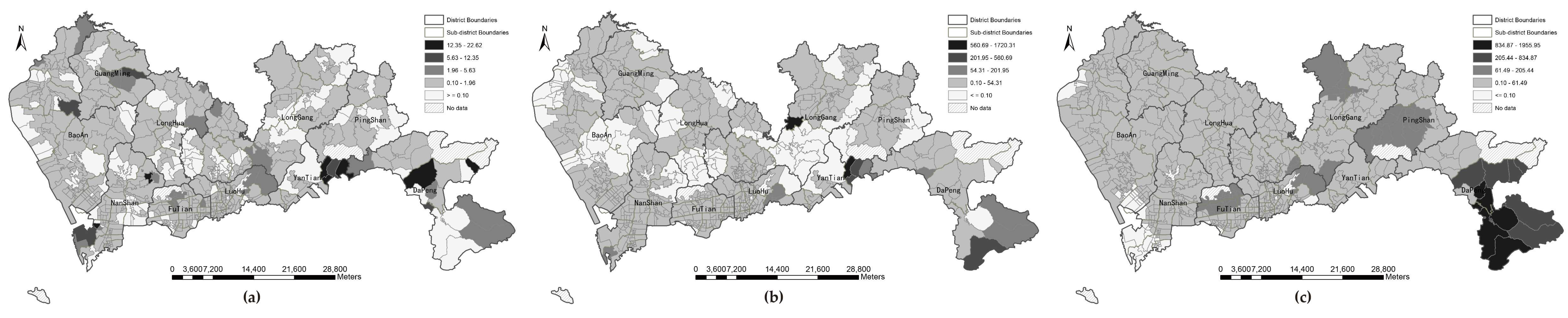
3.2.2. Spatial Analysis of Park Accessibility
3.3. Disparity Analysis of the Supply-to-Demand
4. Conclusions
Author Contributions
Funding
Acknowledgments
Conflicts of Interest
References
- Sun, F.; Xiang, J.; Tao, Y.; Tong, C.; Che, Y. Mapping the social values for ecosystem services in urban green spaces: Integrating a visitor-employed photography method into SolVES. Urban For. Urban Green. 2018. [Google Scholar] [CrossRef]
- Hand, K.L.; Freeman, C.; Seddon, P.J.; Recio, M.R.; Stein, A.; van Heezik, Y. The importance of urban gardens in supporting children’s biophilia. Proc. Natl. Acad. Sci. USA 2017, 114, 274–279. [Google Scholar] [CrossRef] [PubMed]
- Bertram, C.; Rehdanz, K. The role of urban green space for human well-being. Ecol. Econ. 2015, 120, 139–152. [Google Scholar] [CrossRef]
- Wu, C.; Ye, X.; Du, Q.; Luo, P. Spatial effects of accessibility to parks on housing prices in Shenzhen, China. Habitat Int. 2017, 63, 45–54. [Google Scholar] [CrossRef]
- Kroeger, T.; Escobedo, F.J.; Hernandez, J.L.; Varela, S.; Delphin, S.; Fisher, J.R.B.; Waldron, J. Reforestation as a novel abatement and compliance measure for ground-level ozone. Proc. Natl. Acad. Sci. USA 2014, 111, E4204. [Google Scholar] [CrossRef] [PubMed]
- Bowler, D.E.; Buyung-Ali, L.; Knight, T.M.; Pullin, A.S. Urban greening to cool towns and cities: A systematic review of the empirical evidence. Landsc. Urban Plan. 2010, 97, 147–155. [Google Scholar] [CrossRef]
- Maimaitiyiming, M.; Ghulam, A.; Tiyip, T.; Pla, F.; Latorre-Carmona, P.; Halik, Ü.; Sawut, M.; Caetano, M. Effects of green space spatial pattern on land surface temperature: Implications for sustainable urban planning and climate change adaptation. ISPRS J. Photogramm. Remote Sens. 2014, 89, 59–66. [Google Scholar] [CrossRef]
- Zhao, M.; Kong, Z.-H.; Escobedo, F.J.; Gao, J. Impacts of urban forests on offsetting carbon emissions from industrial energy use in Hangzhou, China. J. Environ. Manag. 2010, 91, 807–813. [Google Scholar] [CrossRef]
- Zhang, B.; Xie, G.-D.; Gao, J.-X.; Yang, Y. The cooling effect of urban green spaces as a contribution to energy-saving and emission-reduction: A case study in Beijing, China. Build. Environ. 2014, 76, 37–43. [Google Scholar] [CrossRef]
- Braubach, M.; Egorov, A.; Mudu, P.; Wolf, T.; Ward Thompson, C.; Martuzzi, M. Effects of Urban Green Space on Environmental Health, Equity and Resilience. In Nature-Based Solutions to Climate Change Adaptation in Urban Areas: Linkages between Science, Policy and Practice; Kabisch, N., Korn, H., Stadler, J., Bonn, A., Eds.; Springer International Publishing: Cham, Switzerland, 2017; pp. 187–205. [Google Scholar] [CrossRef]
- Balseviciene, B.; Sinkariova, L.; Grazuleviciene, R.; Andrusaityte, S.; Uzdanaviciute, I.; Dedele, A.; Nieuwenhuijsen, M.J. Impact of residential greenness on preschool children’s emotional and behavioral problems. Int. J. Environ. Res. Public Health 2014, 11, 6757–6770. [Google Scholar] [CrossRef]
- Aspinall, P.A.; Thompson, C.W.; Alves, S.; Sugiyama, T.; Brice, R.; Vickers, A. Preference and Relative Importance for Environmental Attributes of Neighbourhood Open Space in Older People. Environ. Plan. B Plan. Des. 2010, 37, 1022–1039. [Google Scholar] [CrossRef]
- Silveira, I.H.D.; Junger, W.L. Green spaces and mortality due to cardiovascular diseases in the city of Rio de Janeiro. Revista de Saude Publica 2018, 52, 49. [Google Scholar] [CrossRef]
- Picavet, H.S.J.; Milder, I.; Kruize, H.; de Vries, S.; Hermans, T.; Wendel-Vos, W. Greener living environment healthier people?: Exploring green space, physical activity and health in the Doetinchem Cohort Study. Prev. Med. 2016, 89, 7–14. [Google Scholar] [CrossRef]
- Ward Thompson, C.; Roe, J.; Aspinall, P.; Mitchell, R.; Clow, A.; Miller, D. More green space is linked to less stress in deprived communities: Evidence from salivary cortisol patterns. Landsc. Urban Plan. 2012, 105, 221–229. [Google Scholar] [CrossRef]
- Beyer, M.K.; Kaltenbach, A.; Szabo, A.; Bogar, S.; Nieto, J.F.; Malecki, M.K. Exposure to Neighborhood Green Space and Mental Health: Evidence from the Survey of the Health of Wisconsin. Int. J. Environ. Res. Public Health 2014, 11, 3453–3472. [Google Scholar] [CrossRef]
- White, P.C.L.; Wyatt, J.; Chalfont, G.; Bland, J.M.; Neale, C.; Trepel, D.; Graham, H. Exposure to nature gardens has time-dependent associations with mood improvements for people with mid- and late-stage dementia: Innovative practice. Dementia 2017, 17, 627–634. [Google Scholar] [CrossRef]
- Arnberger, A.; Eder, R. The influence of green space on community attachment of urban and suburban residents. Urban For. Urban Green. 2012, 11, 41–49. [Google Scholar] [CrossRef]
- Kaźmierczak, A. The contribution of local parks to neighbourhood social ties. Landsc. Urban Plan. 2013, 109, 31–44. [Google Scholar] [CrossRef]
- Xiao, Y.; Wang, D.; Fang, J. Exploring the disparities in park access through mobile phone data: Evidence from Shanghai, China. Landsc. Urban Plan. 2019, 181, 80–91. [Google Scholar] [CrossRef]
- You, H. Characterizing the inequalities in urban public green space provision in Shenzhen, China. Habitat Int. 2016, 56, 176–180. [Google Scholar] [CrossRef]
- Zhou, X.; Kim, J. Social disparities in tree canopy and park accessibility: A case study of six cities in Illinois using GIS and remote sensing. Urban For. Urban Green. 2013, 12, 88–97. [Google Scholar] [CrossRef]
- Boone, C.G.; Buckley, G.L.; Grove, J.M.; Sister, C. Parks and People: An Environmental Justice Inquiry in Baltimore, Maryland. Ann. Assoc. Am. Geogr. 2009, 99, 767–787. [Google Scholar] [CrossRef]
- Ibes, D.C. A multi-dimensional classification and equity analysis of an urban park system: A novel methodology and case study application. Landsc. Urban Plan. 2015, 137, 122–137. [Google Scholar] [CrossRef]
- Shen, Y.; Sun, F.; Che, Y. Public green spaces and human wellbeing: Mapping the spatial inequity and mismatching status of public green space in the Central City of Shanghai. Urban For. Urban Green. 2017, 27, 59–68. [Google Scholar] [CrossRef]
- Dadashpoor, H.; Rostami, F.; Alizadeh, B. Is inequality in the distribution of urban facilities inequitable? Exploring a method for identifying spatial inequity in an Iranian city. Cities 2016, 52, 159–172. [Google Scholar] [CrossRef]
- Dai, D. Racial/ethnic and socioeconomic disparities in urban green space accessibility: Where to intervene? Landsc. Urban Plan. 2011, 102, 234–244. [Google Scholar] [CrossRef]
- Xiao, Y.; Wang, Z.; Li, Z.; Tang, Z. An assessment of urban park access in Shanghai—Implications for the social equity in urban China. Landsc. Urban Plan. 2017, 157, 383–393. [Google Scholar] [CrossRef]
- Hughey, S.M.; Walsemann, K.M.; Child, S.; Powers, A.; Reed, J.A.; Kaczynski, A.T. Using an environmental justice approach to examine the relationships between park availability and quality indicators, neighborhood disadvantage, and racial/ethnic composition. Landsc. Urban Plan. 2016, 148, 159–169. [Google Scholar] [CrossRef]
- Xu, C.; Haase, D.; Pribadi, D.O.; Pauleit, S. Spatial variation of green space equity and its relation with urban dynamics: A case study in the region of Munich. Ecol. Indic. 2018, 93, 512–523. [Google Scholar] [CrossRef]
- Rigolon, A. A complex landscape of inequity in access to urban parks: A literature review. Landsc. Urban Plan. 2016, 153, 160–169. [Google Scholar] [CrossRef]
- Macintyre, S. Deprivation amplification revisited; or, is it always true that poorer places have poorer access to resources for healthy diets and physical activity? Int. J. Behav. Nutr. Phys. Act. 2007, 4, 32. [Google Scholar] [CrossRef] [PubMed]
- Wolch, J.R.; Byrne, J.; Newell, J.P. Urban green space, public health, and environmental justice: The challenge of making cities ‘just green enough’. Landsc. Urban Plan. 2014, 125, 234–244. [Google Scholar] [CrossRef]
- Lee, G.; Hong, I. Measuring spatial accessibility in the context of spatial disparity between demand and supply of urban park service. Landsc. Urban Plan. 2013, 119, 85–90. [Google Scholar] [CrossRef]
- Xing, L.; Liu, Y.; Liu, X. Measuring spatial disparity in accessibility with a multi-mode method based on park green spaces classification in Wuhan, China. Appl. Geogr. 2018, 94, 251–261. [Google Scholar] [CrossRef]
- Dadashpoor, H.; Rostami, F. Measuring spatial proportionality between service availability, accessibility and mobility: Empirical evidence using spatial equity approach in Iran. J. Transp. Geogr. 2017, 65, 44–55. [Google Scholar] [CrossRef]
- Comber, A.; Brunsdon, C.; Green, E. Using a GIS-based network analysis to determine urban greenspace accessibility for different ethnic and religious groups. Landsc. Urban Plan. 2008, 86, 103–114. [Google Scholar] [CrossRef]
- Xu, M.; Xin, J.; Su, S.; Weng, M.; Cai, Z. Social inequalities of park accessibility in Shenzhen, China: The role of park quality, transport modes, and hierarchical socioeconomic characteristics. J. Transp. Geogr. 2017, 62, 38–50. [Google Scholar] [CrossRef]
- China Architecture & Building Press. Code for Design of Parks; China Architecture & Building Press: Beijing, China, 2009. [Google Scholar]
- Van Herzele, A.; Wiedemann, T. A monitoring tool for the provision of accessible and attractive urban green spaces. Landsc. Urban Plan. 2003, 63, 109–126. [Google Scholar] [CrossRef]
- Dony, C.C.; Delmelle, E.M.; Delmelle, E.C. Re-conceptualizing accessibility to parks in multi-modal cities: A Variable-width Floating Catchment Area (VFCA) method. Landsc. Urban Plan. 2015, 143, 90–99. [Google Scholar] [CrossRef]
- Penchansky, R.; Thomas, J.W. The concept of access: definition and relationship to consumer satisfaction. Med. Care 1981, 19, 127–140. [Google Scholar] [CrossRef]
- Apparicio, P.; Gelb, J.; Dubé, A.-S.; Kingham, S.; Gauvin, L.; Robitaille, É. The approaches to measuring the potential spatial access to urban health services revisited: distance types and aggregation-error issues. Int. J. Health Geogr. 2017, 16, 32. [Google Scholar] [CrossRef] [PubMed]
- Guagliardo, M.F. Spatial accessibility of primary care: concepts, methods and challenges. Int. J. Health Geogr. 2004, 3, 3. [Google Scholar] [CrossRef]
- Khan, A.A. An integrated approach to measuring potential spatial access to health care services. Soc.-Econ. Plan. Sci. 1992, 26, 275–287. [Google Scholar] [CrossRef]
- Joseph, A.E.; Phillips, D.R. Accessibility and Utilization: Geographical Perspectives on Health Care Delivery; SAGE: Newcastle upon Tyne, UK, 1984. [Google Scholar]
- Luo, W.; Wang, F. Measures of Spatial Accessibility to Health Care in a GIS Environment: Synthesis and a Case Study in the Chicago Region. Environ. Plan. B Plan. Des. 2003, 30, 865–884. [Google Scholar] [CrossRef]
- Zhang, X.; Lu, H.; Holt, J.B. Modeling spatial accessibility to parks: a national study. Int. J. Health Geogr. 2011, 10, 31. [Google Scholar] [CrossRef] [PubMed]
- Rioux, L.; Werner, C.M.; Mokounkolo, R.; Brown, B.B. Walking in two French neighborhoods: A study of how park numbers and locations relate to everyday walking. J. Environ. Psychol. 2016, 48, 169–184. [Google Scholar] [CrossRef] [PubMed]
- Bahrini, F.; Bell, S.; Mokhtarzadeh, S. The relationship between the distribution and use patterns of parks and their spatial accessibility at the city level: A case study from Tehran, Iran. Urban For. Urban Green. 2017, 27, 332–342. [Google Scholar] [CrossRef]
- Hansen, W.G. How Accessibility Shapes Land Use AU—Hansen, Walter G. J. Am. Inst. Plan. 1959, 25, 73–76. [Google Scholar] [CrossRef]
- Radke, J.; Mu, L. Spatial Decompositions, Modeling and Mapping Service Regions to Predict Access to Social Programs. Geogr. Inf. Sci. 2000, 6, 105–112. [Google Scholar] [CrossRef]
- Luo, W.; Qi, Y. An enhanced two-step floating catchment area (E2SFCA) method for measuring spatial accessibility to primary care physicians. Health Place 2009, 15, 1100–1107. [Google Scholar] [CrossRef] [PubMed]
- Wan, N.; Zou, B.; Sternberg, T. A three-step floating catchment area method for analyzing spatial access to health services. Int. J. Geogr. Inf. Sci. 2012, 26, 1073–1089. [Google Scholar] [CrossRef]
- McGrail, M.R.; Humphreys, J.S. A new index of access to primary care services in rural areas. Aust. N. Z. J. Public Health 2009, 33, 418–423. [Google Scholar] [CrossRef]
- Bauer, J.; Groneberg, D.A. Measuring Spatial Accessibility of Health Care Providers—Introduction of a Variable Distance Decay Function within the Floating Catchment Area (FCA) Method. PLoS ONE 2016, 11, e0159148. [Google Scholar] [CrossRef] [PubMed]
- Wei, L.; Whippo, T. Variable catchment sizes for the two-step floating catchment area (2SFCA) method. Health Place 2012, 18, 789–795. [Google Scholar]
- McGrail, M.R.; Humphreys, J.S. Measuring spatial accessibility to primary health care services: Utilising dynamic catchment sizes. Appl. Geogr. 2014, 54, 182–188. [Google Scholar] [CrossRef]
- Ni, J.; Wang, J.; Rui, Y.; Qian, T.; Wang, J. An Enhanced Variable Two-Step Floating Catchment Area Method for Measuring Spatial Accessibility to Residential Care Facilities in Nanjing. Int. J. Environ. Res. Public Health 2015, 12, 14490–14504. [Google Scholar] [CrossRef]
- Mao, L.; Nekorchuk, D. Measuring spatial accessibility to healthcare for populations with multiple transportation modes. Health Place 2013, 24, 115–122. [Google Scholar] [CrossRef]
- Xinhua News Agency. National Plan on New Urbanization 2014–2020; Xinhua News Agency: Beijing, China, 2014. [Google Scholar]
- China Statistics Press. China City Statistical Yearbook; China Statistics Press: Beijing, China, 2017. [Google Scholar]
- Zhang, W.; Yu, J.; Zhan, D.; Ma, R. A Study of Livable Cities in China; Science Press: Beijing, China, 2016. [Google Scholar]
- Statistical Data on Urban Administration in Shenzhen. 2016. Available online: http://cgj.sz.gov.cn/zwgk/tjsj/zxtjxx/201703/t20170316_6071074.htm (accessed on 10 December 2018).
- Master Plans for Shenzhen Forest City. Available online: http://cgj.sz.gov.cn/zwgk/ghjh/fzgh/201701/t20170104_5863524.htm (accessed on 20 August 2018).
- Wan, N.; Zhan, F.B.; Zou, B.; Chow, E. A relative spatial access assessment approach for analyzing potential spatial access to colorectal cancer services in Texas. Appl. Geogr. 2012, 32, 291–299. [Google Scholar] [CrossRef]
- Hwang, H.L.; Rollow, J. Data Processing Procedures and Methodology for Estimating Trip Distances for the 1995 American Travel Survey (ATS); Oak Ridge National Laboratory: Oak Ridge, TN, USA, 2000. [Google Scholar]
- Mei-Po, K. Space-Time and Integral Measures of Individual Accessibility: A Comparative Analysis Using a Point-based Framework. Geogr. Anal. 1998, 30, 191–216. [Google Scholar] [CrossRef]
- Tao, Z.; Yao, Z.; Kong, H.; Duan, F.; Li, G. Spatial accessibility to healthcare services in Shenzhen, China: improving the multi-modal two-step floating catchment area method by estimating travel time via online map APIs. BMC Health Serv. Res. 2018, 18, 345. [Google Scholar] [CrossRef]
- Haynes, R.; Jones, A.P.; Sauerzapf, V.; Zhao, H. Validation of travel times to hospital estimated by GIS. Int. J. Health Geogr. 2006, 5, 40. [Google Scholar] [CrossRef] [PubMed]
- Langford, M.; Higgs, G.; Fry, R. Multi-modal two-step floating catchment area analysis of primary health care accessibility. Health Place 2016, 38, 70–81. [Google Scholar] [CrossRef] [PubMed]
- Stessens, P.; Khan, A.Z.; Huysmans, M.; Canters, F. Analysing urban green space accessibility and quality: A GIS-based model as spatial decision support for urban ecosystem services in Brussels. Ecosyst. Serv. 2017, 28, 328–340. [Google Scholar] [CrossRef]
- Longley, P.A.; Goodchild, M.F.; Maguire, D.J.; Rhind, D.W. Geographic Information Science and Systems, 4th ed.; Wiley: Hoboken, NJ, USA, 2015. [Google Scholar]
- Luo, J. Integrating the Huff Model and Floating Catchment Area Methods to Analyze Spatial Access to Healthcare Services. Trans. GIS 2014, 18, 436–448. [Google Scholar] [CrossRef]
- Apparicio, P.; Abdelmajid, M.; Riva, M.; Shearmur, R. Comparing alternative approaches to measuring the geographical accessibility of urban health services: Distance types and aggregation-error issues. Int. J. Health Geogr. 2008, 7, 7. [Google Scholar] [CrossRef] [PubMed]
- Gao, W.; Lyu, Q.; Fan, X.; Yang, X.; Liu, J.; Zhang, X. Building-Based Analysis of the Spatial Provision of Urban Parks in Shenzhen, China. Int. J. Environ. Res. Public Health 2017, 14, 1521. [Google Scholar] [CrossRef] [PubMed]


| District | Population (Million) | Number of Park | Total Park Area (km2) | Park Area per Capita (m2) | ||||||
|---|---|---|---|---|---|---|---|---|---|---|
| Community Park | City Park | Natural Park | Community Park | City Park | Natural Park | Community Park | City Park | Natural Park | ||
| Futian | 0.76 | 147 | 12 | 2 | 0.60 | 7.24 | 7.35 | 0.79 | 9.57 | 9.72 |
| Luohu | 0.92 | 133 | 10 | 3 | 0.66 | 10.85 | 18.22 | 0.72 | 11.74 | 19.72 |
| Yantian | 0.17 | 32 | 8 | 2 | 0.27 | 5.86 | 44.67 | 1.61 | 35.13 | 267.97 |
| Nanshan | 1.17 | 65 | 28 | 1 | 0.94 | 12.23 | 9.91 | 0.80 | 10.45 | 8.47 |
| Bao’an | 4.56 | 142 | 15 | 4 | 2.71 | 6.30 | 34.51 | 0.59 | 1.38 | 7.56 |
| Longgang | 3.45 | 103 | 18 | 7 | 1.35 | 15.16 | 56.13 | 0.39 | 4.40 | 16.28 |
| Longhua | 2.29 | 46 | 5 | 5 | 0.86 | 0.87 | 43.44 | 0.37 | 0.38 | 18.97 |
| Pingshan | 0.46 | 28 | 6 | 3 | 0.14 | 2.22 | 38.14 | 0.31 | 4.84 | 83.31 |
| Guangming | 1.06 | 28 | 4 | 4 | 0.62 | 1.31 | 28.80 | 0.58 | 1.23 | 27.14 |
| Dapeng | 0.10 | 21 | 12 | 3 | 0.46 | 1.57 | 54.11 | 4.40 | 15.00 | 517.84 |
| Distance Type (km) | Mean | P10 | Q1 | Q2 | Q3 | P90 |
|---|---|---|---|---|---|---|
| Euclidean distance | 23.52 | 6.30 | 12.57 | 21.63 | 32.31 | 42.65 |
| Walking distance | 29.96 | 8.17 | 16.52 | 27.44 | 40.61 | 54.01 |
| Bicycling distance | 31.74 | 8.85 | 17.69 | 29.19 | 42.85 | 57.12 |
| Driving distance | 32.02 | 9.1 | 17.37 | 29.39 | 43.82 | 57.57 |
| Distance | Euclidean | Walking | Bicycling | Driving |
|---|---|---|---|---|
| Distances between communities and parks (N) | 599,760 | 599,760 | 599,760 | 599,760 |
| Euclidean distance | 1 | 0.986 ** | 0.985 ** | 0.981 ** |
| Walking distance | 0.986 ** | 1 | 0.997 ** | 0.973 ** |
| Bicycling distance | 0.985 ** | 0.997 ** | 1 | 0.972 ** |
| Driving distance | 0.981 ** | 0.973 ** | 0.972 ** | 1 |
| Level of Parks | Travel Distance Threshold | Distance Mode | Mean | Standard Deviation | Underserved Community (Numbers) | Underserved Areas (km2) | Underserved Population |
|---|---|---|---|---|---|---|---|
| Community park | 2 km | Euclidean | 0.82 | 1.85 | 79 | 328.38 | 2,336,132 |
| Walking | 0.79 | 1.90 | 126 | 471.72 | 3,723,610 | ||
| Bicycling | 0.78 | 1.89 | 137 | 541.78 | 4,125,854 | ||
| Driving | 0.77 | 1.98 | 181 | 675.48 | 5,487,025 | ||
| City park | 5 km | Euclidean | 9.98 | 28.90 | 35 | 165.08 | 1,515,039 |
| Walking | 13.28 | 79.68 | 97 | 545.06 | 3,620,555 | ||
| Bicycling | 11.70 | 49.19 | 100 | 566.75 | 3,766,218 | ||
| Driving | 11.17 | 44.51 | 148 | 716.66 | 5,395,964 | ||
| Natural park | 10 km | Euclidean | 54.82 | 211.38 | 5 | 24.59 | 77,714 |
| Walking | 52.47 | 214.58 | 45 | 66.23 | 781,082 | ||
| Bicycling | 52.27 | 215.24 | 59 | 88.92 | 1,092,732 | ||
| Driving | 54.34 | 225.48 | 74 | 121.67 | 1,288,487 |
| Type of Distance | High Ai—High PopDi | High Ai—Low PopDi | Low Ai—Low PopDi | Low Ai—High PopDi | |
|---|---|---|---|---|---|
| Count | Euclidean | 151 23.97% | 158 25.08% | 71 11.27% | 250 39.68% |
| Walking | 114 18.10% | 138 21.90% | 91 14.44% | 287 45.56% | |
| Bicycling | 113 17.94% | 136 21.59% | 93 14.76% | 288 45.71% | |
| Driving | 114 18.10% | 125 19.84% | 104 16.51% | 287 45.56% | |
| Population | Euclidean | 4,246,057 28.42% | 2,014,124 13.48% | 1,380,564 9.24% | 7,300,112 48.86% |
| Walking | 3,383,533 22.65% | 1,520,657 10.18% | 1,874,031 12.54% | 8,162,636 54.63% | |
| Bicycling | 3,435,872 23.00% | 1,699,450 11.37% | 1,695,238 11.35% | 8,110,297 54.28% | |
| Driving | 3,038,667 20.34% | 1,512,910 10.13% | 1,881,778 12.59% | 8,507,502 56.94% |
© 2019 by the authors. Licensee MDPI, Basel, Switzerland. This article is an open access article distributed under the terms and conditions of the Creative Commons Attribution (CC BY) license (http://creativecommons.org/licenses/by/4.0/).
Share and Cite
Li, L.; Du, Q.; Ren, F.; Ma, X. Assessing Spatial Accessibility to Hierarchical Urban Parks by Multi-Types of Travel Distance in Shenzhen, China. Int. J. Environ. Res. Public Health 2019, 16, 1038. https://doi.org/10.3390/ijerph16061038
Li L, Du Q, Ren F, Ma X. Assessing Spatial Accessibility to Hierarchical Urban Parks by Multi-Types of Travel Distance in Shenzhen, China. International Journal of Environmental Research and Public Health. 2019; 16(6):1038. https://doi.org/10.3390/ijerph16061038
Chicago/Turabian StyleLi, Langjiao, Qingyun Du, Fu Ren, and Xiangyuan Ma. 2019. "Assessing Spatial Accessibility to Hierarchical Urban Parks by Multi-Types of Travel Distance in Shenzhen, China" International Journal of Environmental Research and Public Health 16, no. 6: 1038. https://doi.org/10.3390/ijerph16061038
APA StyleLi, L., Du, Q., Ren, F., & Ma, X. (2019). Assessing Spatial Accessibility to Hierarchical Urban Parks by Multi-Types of Travel Distance in Shenzhen, China. International Journal of Environmental Research and Public Health, 16(6), 1038. https://doi.org/10.3390/ijerph16061038