1. Introduction
Exposure to high air pollutant concentrations results in significant health risks, including increased cancer risks and adverse cardiopulmonary outcomes [
1,
2,
3,
4,
5]. Many of these risks disproportionately burden communities of color and low-income communities [
6], at the same time that these communities face greater vulnerability to air pollution exposure [
7,
8]. In light of these disparities, there are a number of legal and regulatory protections for people of color and low-income households in the United States (US) (including Title VI of the 1964 Civil Rights Act and Executive Order 12898, which has spurred agency guidance for evaluating environmental justice outcomes of agency decisions). There is also a legal framework supporting health effect assessments as part of the environmental review processes [
9].
However, it may not be necessary (or feasible) to conduct comprehensive quantitative health assessments of air pollution exposure in every situation (e.g., in areas where residents are neither disadvantaged nor exposed to pollution). Environmental justice (EJ) screening tools (also referred to as cumulative impact and/or social vulnerability tools, e.g., [
10]) play a critical role in focusing
early attention on areas with a high likelihood of disparate health impacts due to environmental exposures. EJ screening tools can highlight areas where disadvantaged populations face high pollution levels and/or many pollution sources, providing decision makers and communities with insights that can help to focus subsequent attention [
11]. EJ screening tools typically characterize the risk of disproportionate health burden in terms of proximity to various air pollutant sources or coarsely estimated concentrations or health risks (e.g., [
10,
11,
12,
13]). These environmental and health risk indicators are then combined with socioeconomic data (reflecting vulnerability) to identify areas where there is a high potential for elevated health risks and vulnerability. The metrics that are included in different tools vary, in part reflecting the differences in objectives as well as data availability and quality. For example, California’s screening tool, CalEnviroScreen, includes rates of low birth weight, asthma, and unemployment in its vulnerability measure, whereas United States Environmental Protection Agency’s (US EPA’s) screening tool does not [
11,
12].
For several years, the US EPA has employed screening tools internally and in 2010 they began developing EJScreen, a national environmental justice screening tool, incorporating insights from stakeholders and experts as well as from earlier research and screening tools such as CalEnviroScreen [
11]. EJScreen was subsequently released to the public in 2015 [
11]. EJScreen includes twelve environmental indicators (representing risks from a variety of air pollution, water, and hazardous waste exposures) and two demographic indicators (which are derived from up to six demographic measures) [
11]. EJScreen data and maps present the environmental, demographic, and combined measures at the block group and census tract level to allow users to identify vulnerable communities which may experience high pollutant burdens. Importantly, the tool facilitates comparisons across communities, regions, and the nation without significant data gathering costs. The screening tool can be used by stakeholders and decision makers to identify areas where additional assessment or outreach may be merited [
11]. In addition, because the tool is web-based, it allows for communities to access environmental and vulnerability data directly [
11]. Providing access to analytical tools has the potential to empower communities to participate more substantively in decision-making processes [
14,
15]. This is important because many affected communities lack political and technical resources to advocate for effective mitigation strategies [
16].
One of the EPA’s stated goals is “to ensure the screening tool [EJScreen] reflects an appropriate balance between simple, feasible, screening-level information on the one hand, and high-quality data and strong science on the other” [
11] (page 8). Ensuring that screening tools are accurate predictors of more spatially resolved areas of high pollutant burden requires two things: accurate estimates of pollution sources (e.g., emissions locations and rates) and accurate methods for estimating pollution burdens (e.g., concentrations). For the former, Sadd et al. have examined the accuracy of stationary pollution source locations, finding that errors were substantial and that ground-truthing can change the predicted burdens reflected in screening methods [
17]. For the latter, there has not been published research that has determined the degree with which screening tools can accurately identify the spatial distributions of high pollutant burdens. That is, how well do environmental justice screening measures reflect more detailed and reliable pollution estimates? While some amount of noise is inherent in the design of ‘screening’ tools, which are expected to be quickly deployed and serve as signals to warrant additional attention, comparisons to actual environmental burdens can reveal simple modifications that can improve accuracy and still be deployed at a ‘screening’ level of effort.
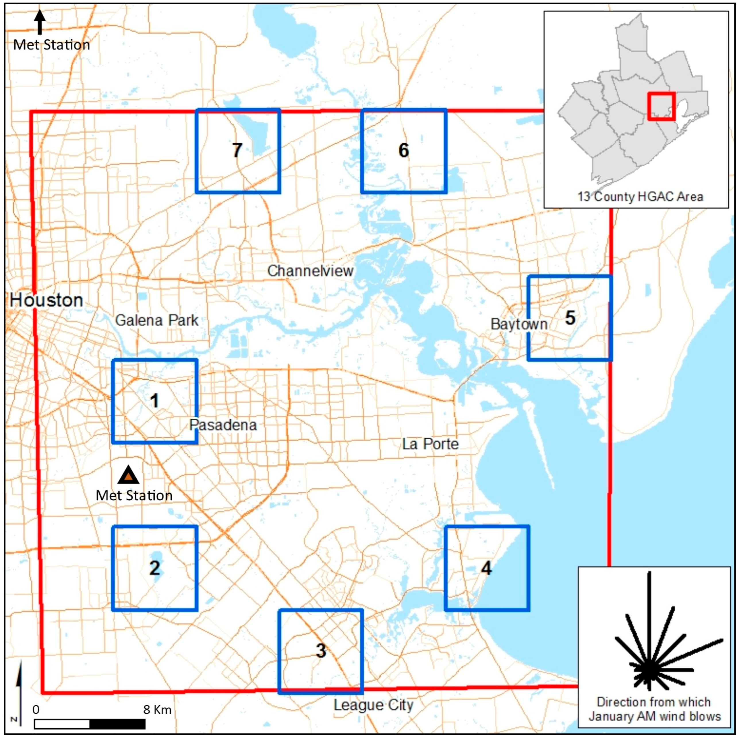
In this study, we explore the accuracy of one environmental measure included in EJScreen: the measure of roadway air pollution. This research is, to the best of our knowledge, the first study to examine the accuracy of a screening method’s estimation of pollution burdens by validating it using detailed modeling. Our analysis focuses on the area around the Houston Ship Channel. The Houston Ship Channel area contains many industrial and mobile air pollution sources, elevated air pollution concentrations [
18,
19,
20], and is an area with a large share of low income people and people of color, all of which contribute to significant environmental justice concerns [
21]. We use fine-grained air pollution dispersion modeling of four pollutants (similar to what is used when performing transportation air pollution conformity analysis) to evaluate the accuracy of EJScreen’s indicator of roadway air pollution concentrations. We then refine EJScreen’s roadway air pollution screening method in three ways: (1) using a smaller unit of analysis, (2) accounting for the length of each road segment, and (3) accounting for wind direction. Each of these refinements provides vehicle emissions concentration indicators that are more closely correlated with modeled vehicle emission concentrations than estimates that were produced using the EJScreen method. Finally, we demonstrate the application of two of the methods by identifying areas of environmental justice concern in the Houston region.
3. Results and Discussion
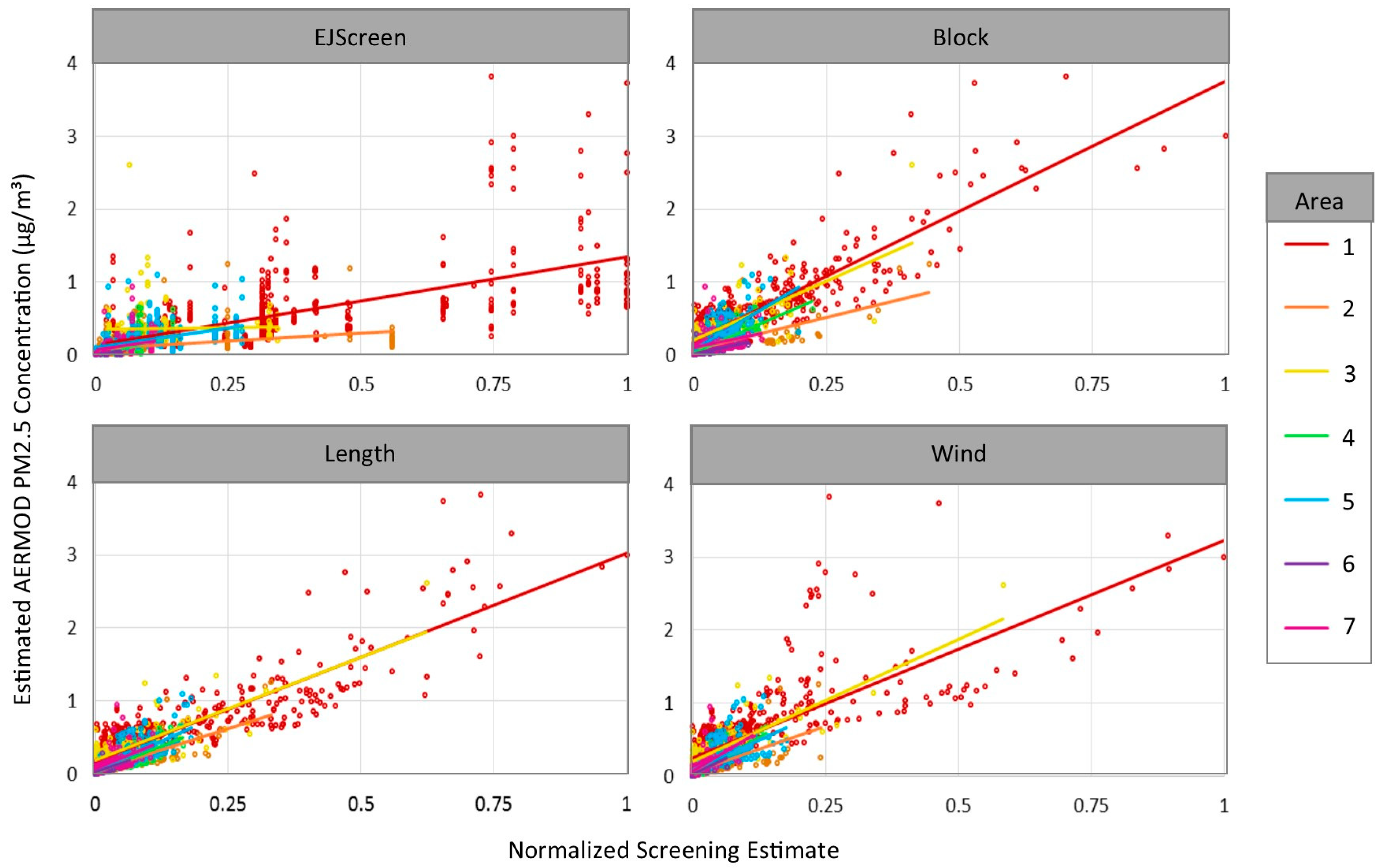
Each of our proposed refinements to the EJScreen method significantly improves the correlations between the modeled PM
2.5 concentrations and the respective roadway air pollution indices for the 2116 populated blocks in the sample areas (
Table 2,
Figure 4). The correlations dramatically improve with the Block Level correction, and additional improvement is seen with the Length correction. Improvements are particularly dramatic in Area 3, where the EJScreen method diverges substantially from the modeled concentrations, which is likely due to variability in the location of highly populated blocks because the EJScreen block-group level estimates are a population weighted average of block-level estimates. The Wind correction does not produce a clear improvement over the Length correction.
In the
Supplementary Materials, we compare the Length and Wind screening method percentiles and the modeled PM
2.5 concentration percentiles along a number of dimensions. The relationship between each screening estimate and the modeled PM
2.5 concentrations are similar. Both methods underestimate pollutants when the nearest road is between 500 and about 800 to 1000 m away, indicating that the 500 m cutoff for multiple road inclusion may be too small. For example, if roads at 800 m have an effect, then error would be introduced when only the nearest of several road segments located 600 m away are included in the assessment. There is, however, no clear reason for the lack of additional clarity brought by the Wind method. It is possible that additional refinements to the wind method (such as accounting for wind speed, which affects pollution distance, adjusting the distance pollution is assumed to be transported by “calm” wind conditions, or aggregating to fewer than 16 directions) would result in improved estimates.
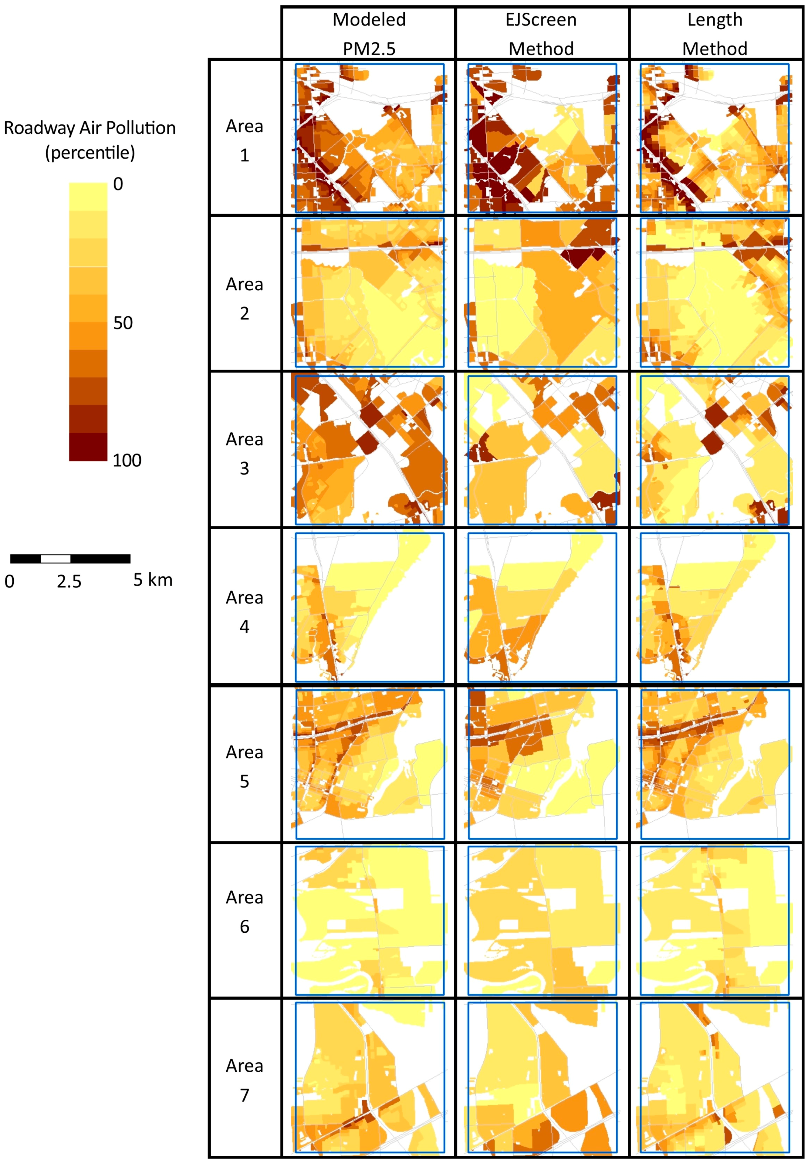
Figure 5 maps the modeled PM
2.5 concentration and the EJScreen and Length roadway air pollution indices for each of the seven sample areas. Metric values are shown as a percentile to facilitate visual comparisons. Percentiles are estimated relative to values in all sample areas combined, so that identical concentrations have the same percentile in different sample areas. As might be expected given the results that are shown in
Table 2, the Length correction appears to better approximate modeled PM
2.5 roadway concentrations in most areas. In contrast, the roadway index for EJScreen tends to show greater concentrations in locations that are further from roadways; this is largely due to the coarse grain of a block group-level analysis. In
Figure 4, the Length method appears to have the weakest relationship to modeled pollutants in Area 3, although
Table 2 and
Figure 5 indicate that it performs reasonably well. This difference relates to the different sizes of the blocks; in Area 3, many small blocks perform well, while several large blocks perform poorly (but dominate the visual impression). Additionally, Areas 1 and 3 present visual examples of the underestimates exhibited by the Length method for blocks with centroids that are more than 500 m from a busy road (consistent with the discussion above).
To better understand how the new index translates into the identification of areas with the greatest potential for environmental disparities in the region, we also calculated a block-level vulnerability index as the average of the percent of residents that are people of color (non-white and/or Hispanic, using the 2010 Census) and the percent of residents that are low-income (living at less than twice the poverty level, from five-year 2013 American Community Survey). We then multiply the Length roadway air pollution index percentile by the vulnerability index for each block to derive a Length roadway EJ index. This approach is consistent with one approach that is used in EJScreen (Supplementary EJ Index 2 using the Demographic Index), except that the analysis is conducted at the block level. To derive an EJScreen roadway EJ index, we estimate the vulnerability index at the block group level and multiply it by the EJScreen roadway air pollution index (also derived at the block group level). We also translate both roadway EJ indices into percentiles (relative to the entire region) to facilitate comparisons.
We compared the differences in the areas of concern across the region identified by the two different roadway EJ indices.
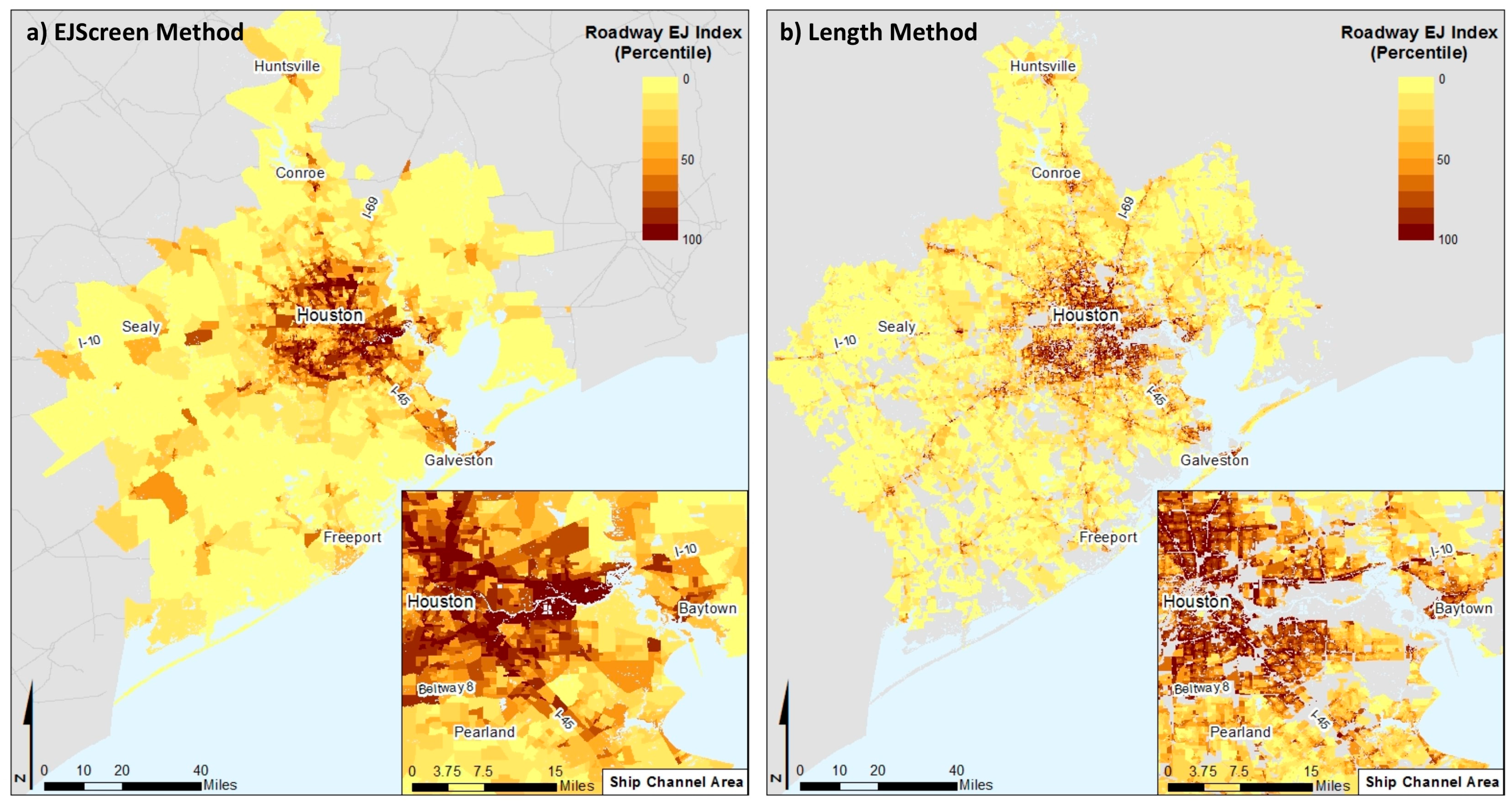
Figure 6 shows the roadway EJ index values as percentiles, where darker shades highlight areas that have both elevated roadway pollution burdens and elevated vulnerability. The roadway EJ index that is arrived at using the Length method captures finer grained areas and identifies areas near high traffic volume roads. In contrast, the highest EJ index values using the EJScreen method are large areas; these block groups are so large that much of the area is not adjacent to roads.
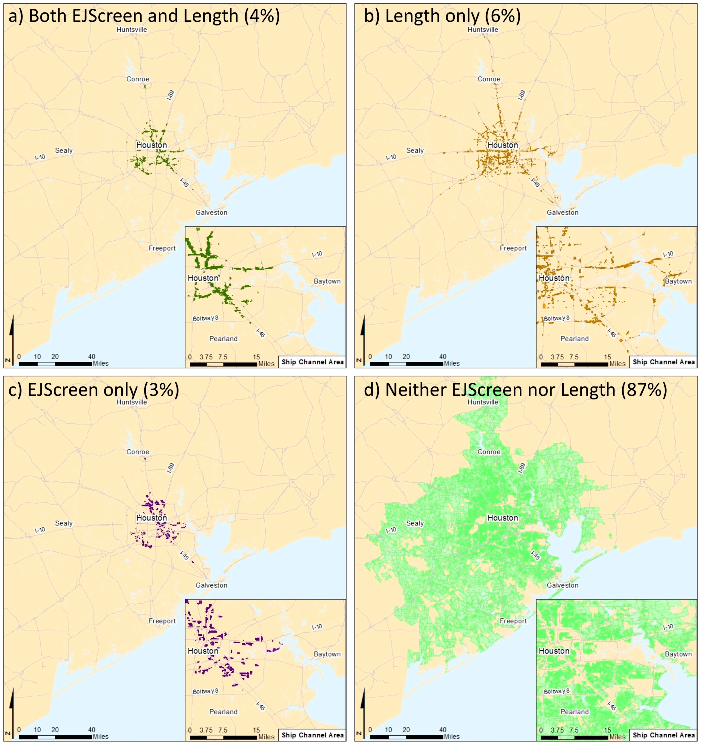
If we identify areas of concern as populated blocks that are at or above the 90th percentile for the EJScreen and Length roadway EJ indices (
Figure 7), we find that both methods identify 4% of all blocks in the region (
Figure 7a), 6% of blocks are identified by the Length method only (
Figure 7b), 3% are identified by the EJScreen method only (
Figure 7c), and 87% of the blocks are below the 90th percentile using both methods (
Figure 7d).
Figure 7 shows that there is likely a misclassification of environmental justice concerns, with the areas identified using each method differing more than they overlap. As discussed above, the Length method captures a finer grained area near busy roads. In light of the greater correspondence of the Length method to the modeled air pollution concentrations, we see that, at fine-grained local scales, EJScreen fails to capture many areas of concern.
4. Conclusions
We have demonstrated that the roadway air pollution index method used in EJScreen can be adapted to provide a more accurate transportation air pollution screening assessment at the regional and local level by applying the screen at the census block level and correcting for the roadway length. We note that these improvements do not require any additional data, as they rely on the same traffic data source that is currently used in EJScreen. With these refinements, EJScreen shows a stronger correlation with modeled roadway pollutant concentrations and better identifies potentially impacted environmental justice communities.
The refined index that is proposed here could be applied to the evaluation of transportation pollution reduction policies at regional and local scales. For example, the refined screening index might be used to conduct preliminary assessments of the impacts of truck idling reduction programs, clean fleet requirements, VMT reductions, and other programs that target a reduction in transportation emissions. Although our refinements of EJScreen were directed to the local and regional levels, it is possible that the new approach would also improve larger scale analyses, although the refinement may require more experimentation for larger networks. If these improvements were incorporated into future versions of EJScreen, then these more refined insights would also be readily available to decision makers and to disadvantaged communities.
There are several limitations to the refined index proposed here. The refinements to EJScreen are most suitable for analyzing potentially high roadway emissions. The ability of the refined screening tool to accurately reflect mobile source pollutant burdens will be a function of the spatial resolution of the roadway network. Future research might explore using a radius that is greater than 500 m, estimating the screening method for a fine grid (rather than at block centroids), and assigning the average of all included points to each block; improving the Wind method by accounting for the wind speed, adjusting the dispersion radius for calm conditions, or using fewer wind directions (or an average of several adjacent wind directions).
This analysis focuses on just one metric included in EJScreen: the roadway air pollution metric. Similar refinements could also be explored for other pollution metrics that are included in EJScreen or other screening tools using other data sources and/or methodological improvements. These refinements could use an approach that is similar to what is presented here, whereby refinements are validated using more detailed modeling of pollution burdens.


