Article

Assessing the Underlying Drivers of Change over Two Decades of Land Use and Land Cover Dynamics along the Standard Gauge Railway Corridor, Kenya

by
Catherine C. Sang
1,2,*,
Daniel O. Olago
1,
Tobias O. Nyumba
1,3,4,
Robert Marchant
4 and
Jessica P. R. Thorn
4,5
1
Institute for Climate Change and Adaptation, Department of Earth and Climate Science, University of Nairobi, Nairobi 00100, Kenya
2
Department of Environmental Monitoring, Planning and Management, University of Eldoret, Eldoret 30100, Kenya
3
African Conservation Centre, Nairobi 00509, Kenya
4
Department of Environment and Geography, University of York, 290 Wentworth Way, Heslington, York YO10 5NG, UK
5
School of Geography and Sustainable Development, University of St Andrews, Irvine Building, North Street, St Andrews KY16 9AL, UK
*
Author to whom correspondence should be addressed.
Sustainability 2022, 14(10), 6158; https://doi.org/10.3390/su14106158
Submission received: 7 March 2022 / Revised: 27 April 2022 / Accepted: 7 May 2022 / Published: 19 May 2022
(This article belongs to the Section Sustainable Management)

Abstract

:
Land cover has been modified by anthropogenic activities for thousands of years, although the speed of change has increased in recent decades, particularly driven by socio-economic development. The development of transport infrastructure can accelerate land use land cover change, resulting in impacts on natural resources such as water, biodiversity, and food production. To understand the interaction between land cover and social–ecological drivers, changing land cover patterns and drivers of change must be identified and quantified. This study documents land cover dynamics along the Standard Gauge Railway (SGR) corridor in Kenya and evaluates the underlying drivers of this change from 2000 to 2019. The study utilised GIS and remote sensing techniques to assess the land use and land cover changes along the SGR corridor, while correlational and regression analyses were used to evaluate various drivers of the changes. Results showed that built-up areas, bare lands, water bodies, croplands and forests increased by 144.39%, 74.73%, 74.42%, 9.32% and 4.85%, respectively, while wetlands, grasslands and shrub lands reduced by 98.54%, 67.00% and 33.86%, respectively. The underlying drivers responsible for these land use and land cover dynamics are population growth, urbanisation, economic growth and agro-ecological factors. Such land cover changes affect environmental sustainability, and we stress the need to adequately identify and address the cumulative social and environmental impacts of mega-infrastructure projects and their interacting investments. The findings of this study provide an evidence base for the evaluation of the social–ecological impacts of the SGR and the implementation of best practices that will lead to enhanced sustainability in the development corridors in Kenya and beyond.

1. Introduction

Economic development and urbanisation worldwide have triggered substantial land use and land cover (LULC) change and influenced ecosystem functioning [1,2]. In recent years, national and transnational mega-infrastructure projects, commonly referred to as development corridors, have been initiated in sub-Saharan Africa [3] and have expanded in number and extent at a high rate [4,5,6]. The construction of infrastructure such as roads and railways together with the associated urban development often results in landscape modifications and changes in human activities in the areas where they traverse [7,8,9,10]. The LULC changes lead to deforestation, water scarcity, loss of biodiversity [11,12] and water pollution [13]. While social development and poverty reduction are key objectives of many development corridors; Hope and Cox (2015) observed that less attention has been given to impacts on natural capital (e.g., water, forests, and other key biodiversity areas) which directly impact local livelihoods [14]. It should be imperative to carry out LULC change analysis as a baseline to inform decision making, ecological management, and environmental planning for the future [15] to engender sustainable socio-economic development [1,16,17]. There is a need to enhance the social benefits of the development corridors, and to devise and embrace strategic approaches that incorporate the understanding of the ecosystem services that communities benefit from along the corridors [14].
LULC change analysis provides evidence for human interference in the natural landscape and helps quantify the resultant environmental impacts from mega-infrastructure investments [18]. This is essential for the management and monitoring of natural resources [18,19], especially in vast developing landscapes such as cities and mega-infrastructure corridors. Several studies have shown that there is a significant relationship between land use patterns and both water quality and quantity, e.g., [20,21,22], as well as agricultural, industrial, and urban activities [23,24,25,26,27,28]. To enhance land resource use efficiency, and mitigate the negative impacts of LULC change, the factors driving land use changes should be identified and evaluated [29]. This, according to Sloan et al. [30], contributes toward proactive regional planning approaches that address environmental and social dynamics.
Despite the long history of development corridors, there is still a lack of clear guidance on how to plan, design, and assess their potential impacts [14]. While previous studies on the LULC changes in mega infrastructure corridors have been conducted in other parts of the world [31,32], research has rarely been done in Kenya. Furthermore, the appreciation of the interactions between ecological systems and infrastructure is just emerging in developing countries [5]. The main objective of this study was, therefore, to document landscape dynamics along the Standard Gauge Railway (SGR) corridor by analysing the LULC changes from 2000 to 2019 and assessing the underlying drivers. Findings of this study will provide an evidence base for the evaluation of the social–ecological impacts of the SGR and promote best practices that will lead to greater sustainability not only along subsequent sections of the SGR, but other transport infrastructure in Kenya such as the Lamu Port South Sudan and Ethiopia Transport corridor, and beyond.

2. Materials and Methods

2.1. Study Area and SGR Project Description

The Standard Gauge Railway (SGR) and Lamu Port-South Sudan-Ethiopia Transport (LAPSSET) corridors were conceived as some of Kenya’s flagship projects for the attainment of its Vison 2030 development agenda which aims at “transforming the country into a newly industrialising middle-income country providing a high quality of life to all its citizens by 2030 in a clean and secure environment” [33] (p. 1). The construction of the SGR and the superhighways along with an extensive expansion of rural road network is expected to accelerate the rate of urbanisation in the country [34]. It is important to note that most of the areas traversed by the SGR, especially in phases 1 and 2A, are characterised by drylands. The SGR furthermore crosses several water catchments, key biodiversity areas, water bodies and forests; thus, the potential to interfere with the natural ecosystems’ functioning and provision of ecosystem services is high [6].
The study area is 14,963 km2 and covers the SGR line from Miasenyi station in Taita Taveta, one of the counties along the Indian Ocean coast to Kisumu which lies on the eastern coastline of Lake Victoria, with a buffer zone of 10 km (Figure 1). A 10 km buffer on either side of the linear infrastructure is considered the immediate area of influence of the linear infrastructure [35,36]. The altitude ranges from 372 m in the coastal region to 2455 m above sea level in the central region and some parts of the Rift Valley.
The SGR construction began in December 2014 from Mombasa, and phase 1 which runs from Mombasa to Nairobi (472 km) was completed and officially opened in May 2017. It traverses eight counties, namely Mombasa, Kilifi, Kwale, Taita Taveta, Makueni, Machakos, Kajiado, and Nairobi, though the study focused on the section between Miasenyi station (Taita Taveta county) and Athi river station (Machakos county). Phase 2A which runs from Nairobi to Suswa (120 km). Construction began in October 2016 and was inaugurated in October 2019. It passes through five counties: Nairobi, Kajiado, Kiambu, Nakuru and Narok. Phase 2B from Narok to Kisumu (262 km) is planned to pass through four counties, namely Narok, Bomet, Kericho and Kisumu and is yet to be constructed. Apart from the SGR, other mega-infrastructure government-funded projects lie along the corridor, including the Konza Techno City and the Naivasha Inland Depot (Figure 1). Most of the areas traversed by phases 1 and 2A receive an average of between 350 mm and 1000 mm of rainfall annually, while the proposed phase 2B areas receive more than 1000 mm on average annually. The mean annual temperature ranges from 15 °C to 24 °C. The SGR line traverses a wide range of ecosystems, mostly savanna, shrub land and grasslands, which characterise semi-arid lands except towards the western region where it passes through increasingly agriculturally dominated areas.

2.2. Methods

The study utilised GIS techniques and correlation statistics to determine the LULC changes over time and associated drivers of change.

2.2.1. Land Use and Land Cover (LULC) Mapping

Data Source and Image Processing

The LULC for 2000, 2010 and 2019 were derived from Landsat 7 ETM, Landsat 5 TM, and Landsat 8 ETM, respectively, with a resolution of 30 m. The acquisition dates for the images ranged from January to March. The corridor is covered by 10 scenes whose image paths/rows were 167/061, 167/062, 167/063, 168/060, 168/061, 168/062, 169/060, 169/061, 170/060 and 170/061. The satellite images were downloaded from the United States Geological Survey (USGS) website (https://earthexplorer.usgs.gov/, accessed on 17 October 2020), processed in ERDAS Imagine and exported to ArcGIS 10.6 for further analysis. The image processing involved radiometric correction, geometric correction, image enhancement, atmospheric correction, layer stacking, image mosaicing, and image sub-setting [37,38]. This increased the accuracy and enhanced the interpretability of the satellite images.

Image Classification and Production of the LULC Maps

The first step was to create signatures where different land uses were identified visually and the signatures were used to create the training sites. All satellite data were studied by assigning per-pixel signatures based on the specific Digital Number (DN) value of different landscape elements. We used supervised classification and applied the maximum likelihood algorithm. Within supervised classification the analyst chooses the pixels that represent the ground land cover types or classes of interest [15]; informed by training samples the image processing software used these chosen samples as a reference for the classification of all other pixels in the image. The supervised classification involves three steps: selecting training areas, generating the signature file and classifying the image. The supervised maximum likelihood classification method was preferred for this study because it is considered one of the most reliable techniques, as the pixels are assigned to the class of highest probability [39]. LULC classification was based on Anderson et al. [40] classification system, with eight classes considered: forest, cropland, shrub land, bare land, built-up, grassland, wetland, and water.

Accuracy Assessment

For the process of LULC change analysis to be credible, it is essential to perform an accuracy assessment of the classification to ascertain the quality of the information derived. As described by [41], accuracy assessments are usually done by comparing two sets of information: the classified image derived from remotely sensed data and reference data, e.g., ground truth/observed data, high-resolution data, and reference maps. Accuracy assessment was carried out based on [41] to quantitatively assess how effectively the pixels were sampled into the correct land cover classes. Accuracy assessment points were created randomly resulting in two major fields; classified image, and ground truth/reference data. Google Earth Engine and Google Earth Explorer were used as reference data for the validation of the classification results for 2000 and 2010 [15]. For 2019, we used a total of 500 randomly selected and evenly distributed sample points, which included 279 reference points picked from a field visit and 221 points from Google Earth for the areas that were not visited. A comparison of classification results and reference data was carried out using confusion (error) matrices [42,43] computed in ArcMap 10.6 using algorithms obtained from [44]. A nonparametric Kappa test was also performed to measure the extent of classification accuracy [15,18,45,46].
To improve classification accuracy and reduction of misclassifications, post-classification refinement was used [47,48,49]. The visual interpretation was applied to enhance the classification accuracy and hence the quality of the LULC maps produced. Once the image accuracy was verified, final LULC maps were produced. The areas covered by the various classes in 2000, 2010 and 2019 were calculated.

Land Use and Land Cover Change Analysis

The LULC change analysis was done by comparing the areas covered by the LULC changes considered in the three time periods. The change in areas was determined by subtracting the area covered in the initial year from the area covered in the final year. The percentage change was calculated by expressing the difference in the area covered by a LULC class in the final and the initial year as a percentage of the area covered in the initial year.

2.2.2. Drivers for Land Use Land Cover Changes along the SGR Corridor

(a)
Biophysical Factors
To analyse what biophysical factors drive LULC change in the SGR corridor, factors of climate and altitude were considered using Agro-Ecological Zones (AEZs) as a compound surrogate measure as the climate of the region is strongly related to altitude [50]. The LULC maps were overlaid with the AEZs in ArcMap 10.6 to establish how they co-vary. AEZs are land units defined based on combinations of soil, landforms and climatic characteristics and having a specific range of potentials and constraints for land use [51]. The spatial distribution of the LULC classes and the temporal changes were assessed in the dominant AEZs along the corridor.
The SGR corridor traverses three major Agro-Ecological Zones (AEZs), namely lower midland, upper midland, and lower highland (Table 1). The lower midland includes parts of Makueni and Taita Taveta counties which are further classified as semi-arid, and Kisumu, Nandi and Kericho counties which are further classified as semi-humid and subhumid areas. The upper midland covers parts of Machakos, Kajiado and Nakuru counties (mainly arid) and Nairobi City and Kiambu classified as semi-arid areas. The lower highland zones are found in parts of Narok (semi-humid) and Bomet (subhumid) (Table 1).
(b)
Socio-Economic Factors
The socio-economic factors considered in the study were population growth, urbanisation, and economic development. The population data were obtained from the Kenya National Bureau of Statistics (https://www.knbs.or.ke/, accessed on 12 July 2020); we used the data for 1999, 2009 and 2019 because those were the available data for the study period. The Gross Domestic Product (GDP) per capita was obtained from the World Bank reports [52]. Pearson’s correlation and linear regression analyses (at 95% confidence level) were performed to establish the relationships between the LULC classes, rural and urban population, and GDP per capita. We started by drawing scatter diagrams to establish relationships between LULC and the three factors. In addition, a simple correlation coefficient was computed to determine the degree of the linear relationship between the variables before regression analysis. Correlation and regression analyses have been used before to determine the underlying drivers for LULC changes [15]. The urban population growth was used as an indicator for urbanisation (defined as the proportion of the country’s population living in the urban areas [53]), while the GDP per capita was used as an indicator for economic growth [54].

3. Results

3.1. Accuracy Assessment

The confusion matrix results showed that the overall accuracy for 2000, 2010 and 2019 were 84%, 85% and 87%, while the Kappa indices were 0.81, 0.82 and 0.84, respectively. Based on this, the accuracy evaluation results for the three epochs showed almost perfect agreement between the classified classes and the actual LULC [46]. The LULC results were, therefore, good for the assessment of the LULC changes along the corridor.

3.2. Land Use and Land Cover for 2000, 2010 and 2019

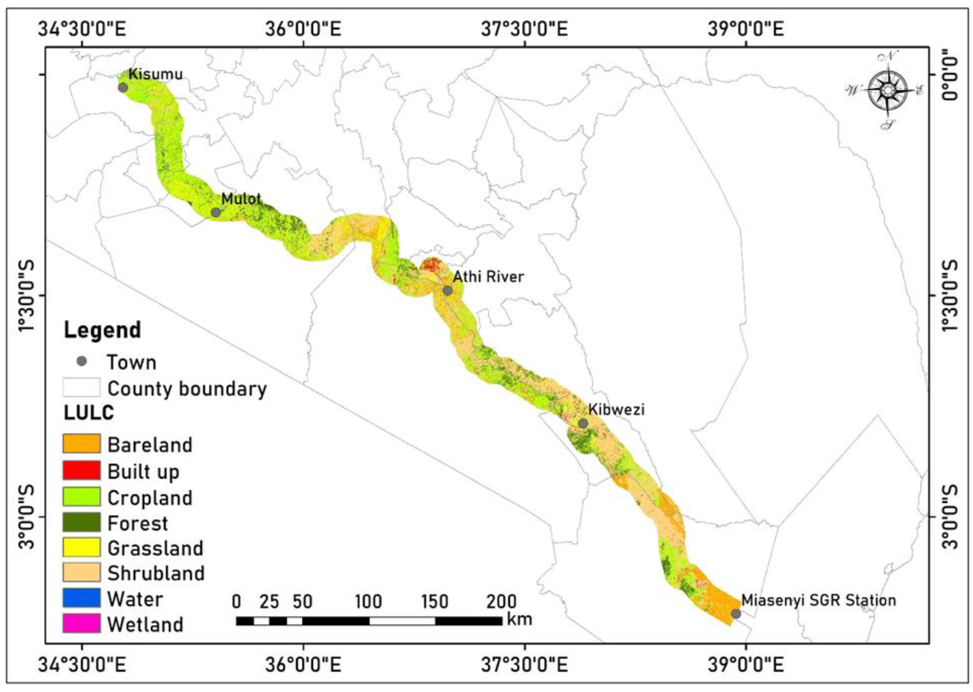
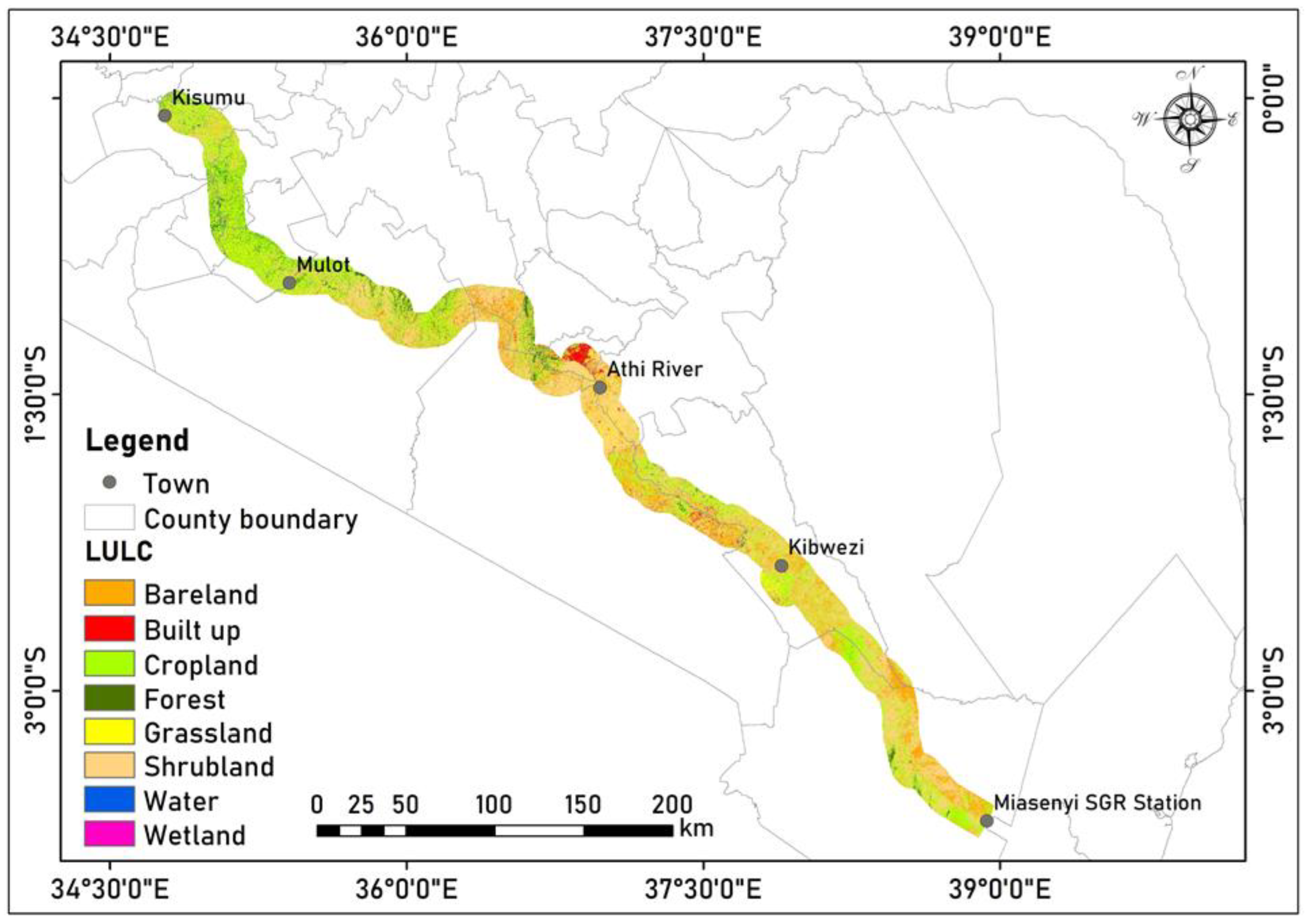
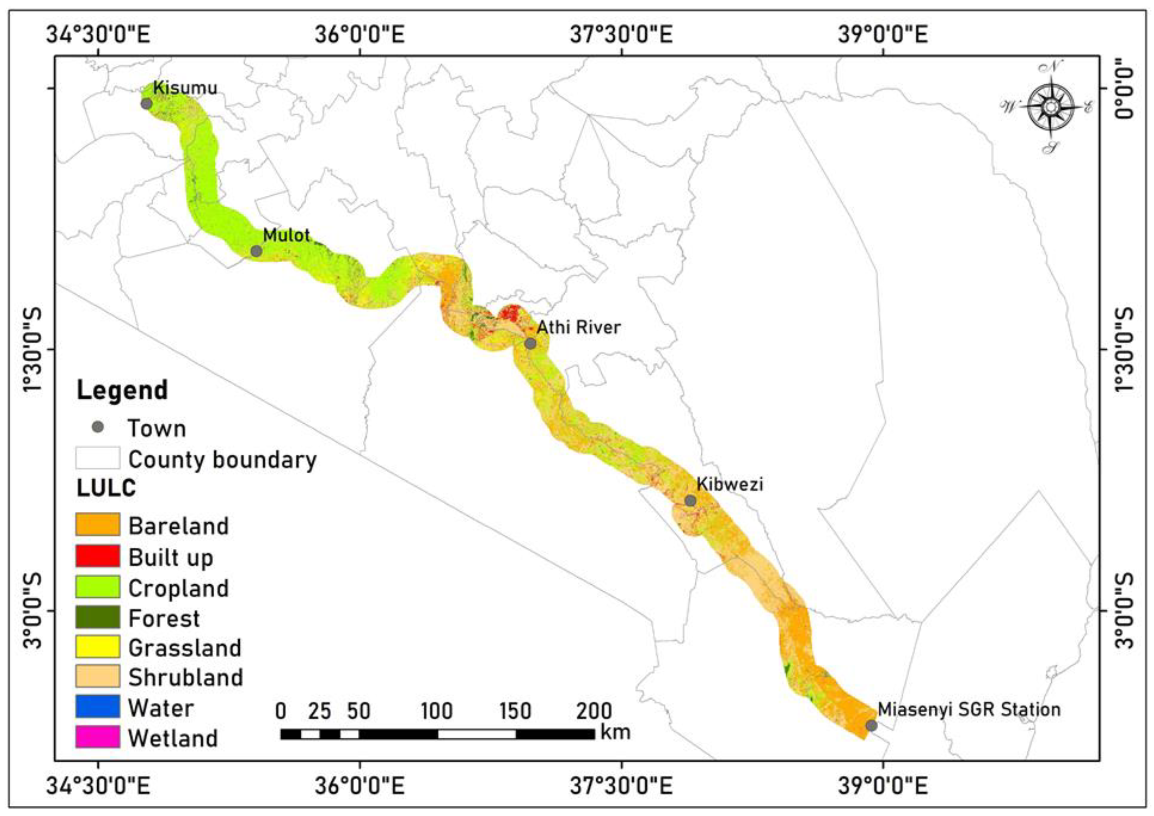
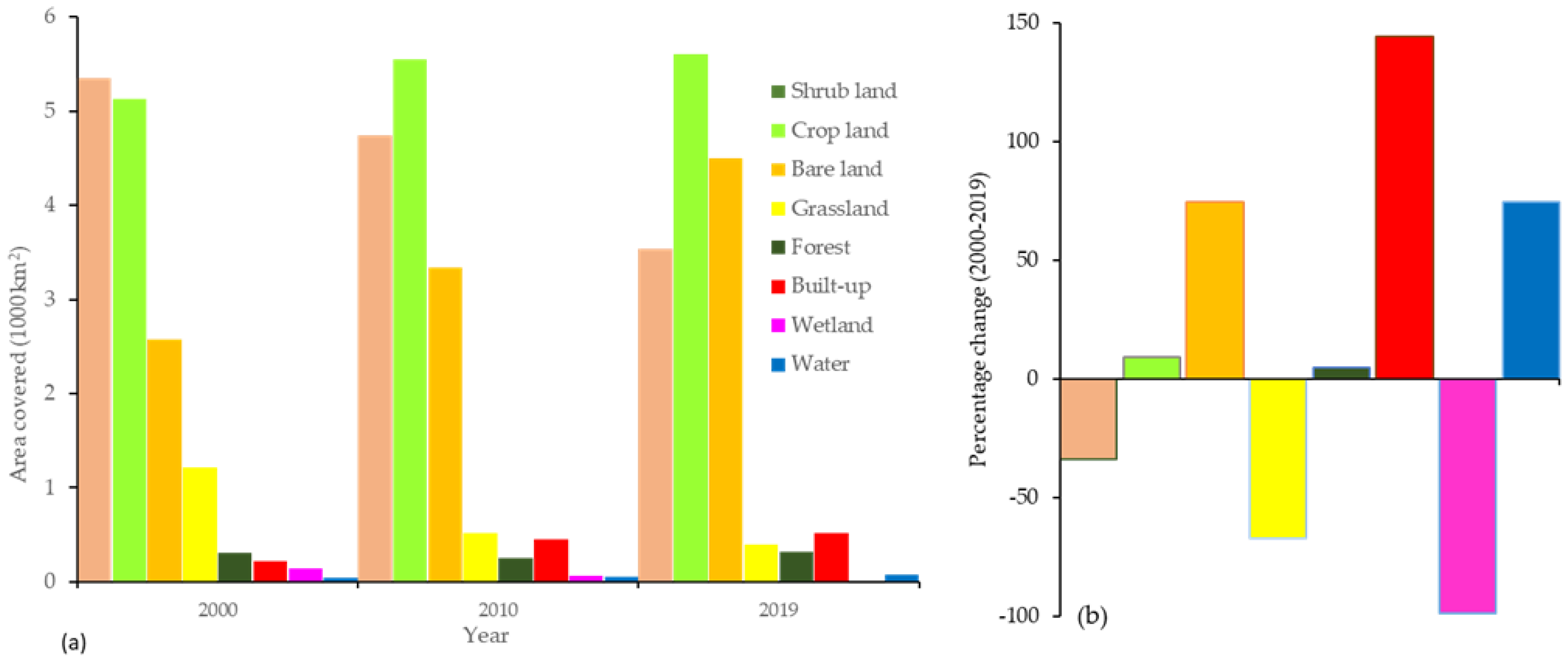
The results revealed that shrub land covered the highest portion of the SGR corridor, followed closely by cropland and then bare land, in the three time periods (Figure 2, Figure 3 and Figure 4). These three LULC classes were followed by grassland, forest, built-up land, wetland and water in that order in 2000. However, there was a slight difference in 2010 and 2019 where the built-up area increased and occupied the fifth and fourth largest portion in 2010 and 2019, respectively (Figure 5a).

3.3. Land Use and Land Cover Change between 2000 and 2019

Many changes in the LULC occurred along the corridor from 2000 to 2019. In the period 2000–2010, the highest increase in terms of area covered was that of bare land, followed by cropland, then built-up areas, and lastly water bodies. During the same period, there was a decrease in grasslands, shrub land, wetlands and forest (Figure 5b). It is important to note that in terms of percentage change, built-up areas had the highest increase (+109.81%) while the highest decrease was that of grasslands (−57.57%) (Figure 5b).
The period between 2010 and 2019 also showed substantial changes. The LULC classes that increased during this period include bare land, forest, built-up area, cropland, and water. On the other hand, the LULC classes that declined were wetlands, shrub lands and grasslands (Figure 5b). In terms of percentage change, the bare land had the highest increase of 34.83% while the highest decrease was observed in the wetland (−96.88%). The 2010–2019 period coincided with the construction of the SGR (2014 to 2019) and the implementation of the Constitution of Kenya 2010 which paved the way for a shift from a centralised to a devolved system of government; and this could explain the increase in built-up and bare land.
The results of the LULC changes in the entire 20-year study period (2000–2019) indicate that the LULC classes that increased were bare land, cropland, built-up area, water, and forest, while shrub land, grassland and wetland decreased. In terms of percentage change, the built-up areas had the highest increase of 144.39% while the highest decrease was observed in the wetland (−98.54%) (Figure 5b). Over the three decades, most shrub lands were converted to bare land, whilst grassland was converted to the built-up area and croplands.

3.4. Drivers of Land Use Land Cover Changes in the SGR Corridor

3.4.1. Biophysical Factors

The Land Use and Land Cover Changes across the AEZs between 2000 and 2019

The results of the LULC and AEZs overlay showed that the spatial distribution of the LULC varies with the AEZs where different LULC classes were found to be dominant in the different AEZs (Table 2, Table 3 and Table 4). On the spatial distribution of LULC classes with respect to AEZs, we found that there was a slight difference in terms of the dominant LULC in the different zones. The lower midland zone was dominated by shrub land over the entire period (2000–2019), especially within the Miasenyi-Kibwezi-Athi river section which is mainly a semi-arid area. In the same zone, cropland had the second-highest cover, and this was found mostly in the Mulot-Kisumu section (particularly parts of Kericho, Nandi and Kisumu) which is generally within the semi-humid and subhumid regions. The main crops suitable for these regions are sugarcane and cotton [51]. In the upper midland zone, the croplands occupied most of the zone and were followed closely by the shrub land with almost the same proportion. The lower highland zone was covered mainly by cropland during the entire period and with a higher share than the upper midland zone.

Changes in LULC in the AEZs

Changes in the different classes varied with the AEZs across the study period. In the lower midland, the highest increase was registered in the built-up area followed closely by bareland. On the other hand, the highest losses were experienced in the wetland and grassland. In the upper midland and lower highlands, water had the highest increase followed by the built-up area, while wetland and grassland had the highest decrease, although the magnitudes varied across the two AEZs (Table 2, Table 3 and Table 4).

3.4.2. The Socio-Economic Factors

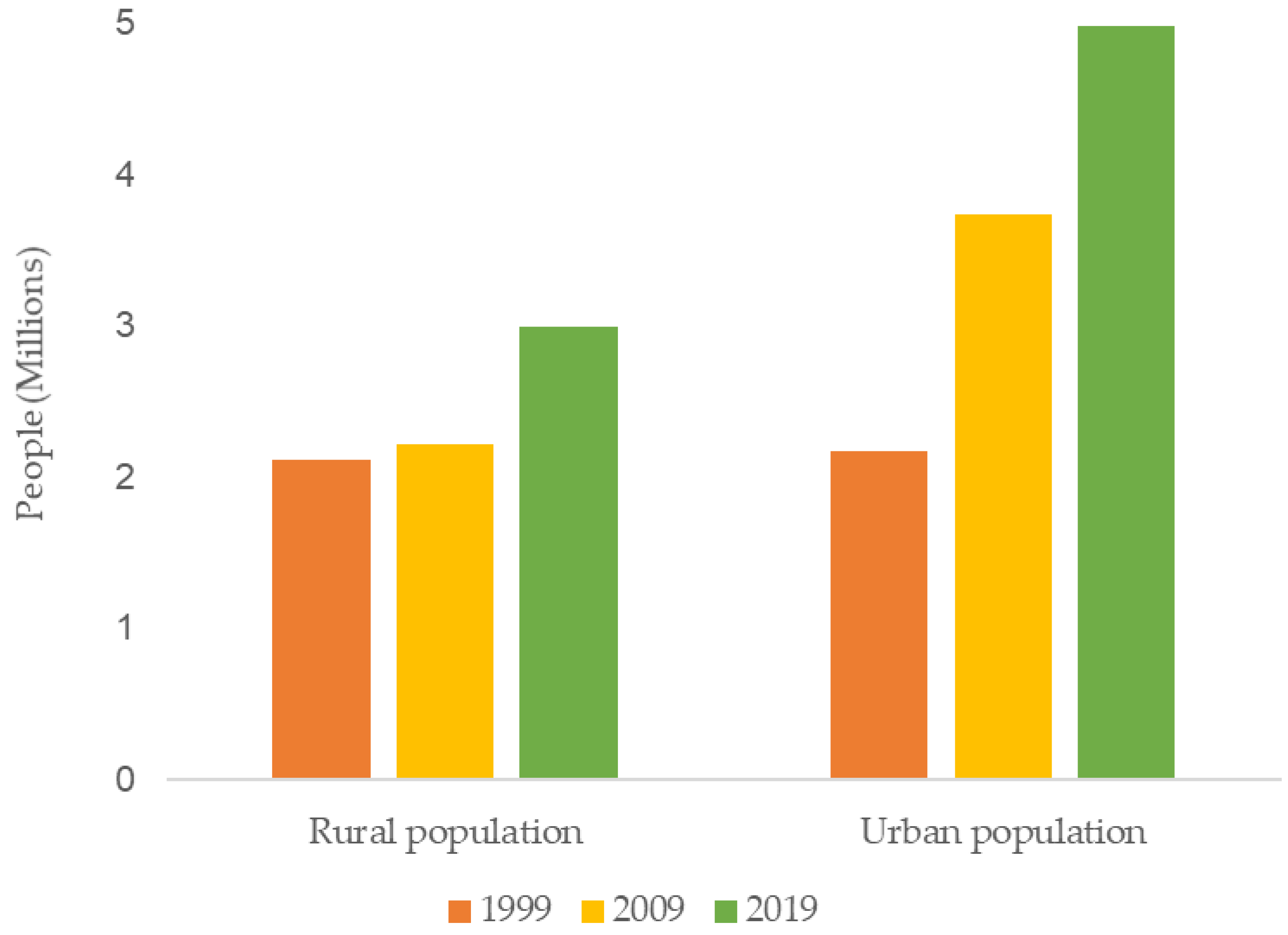
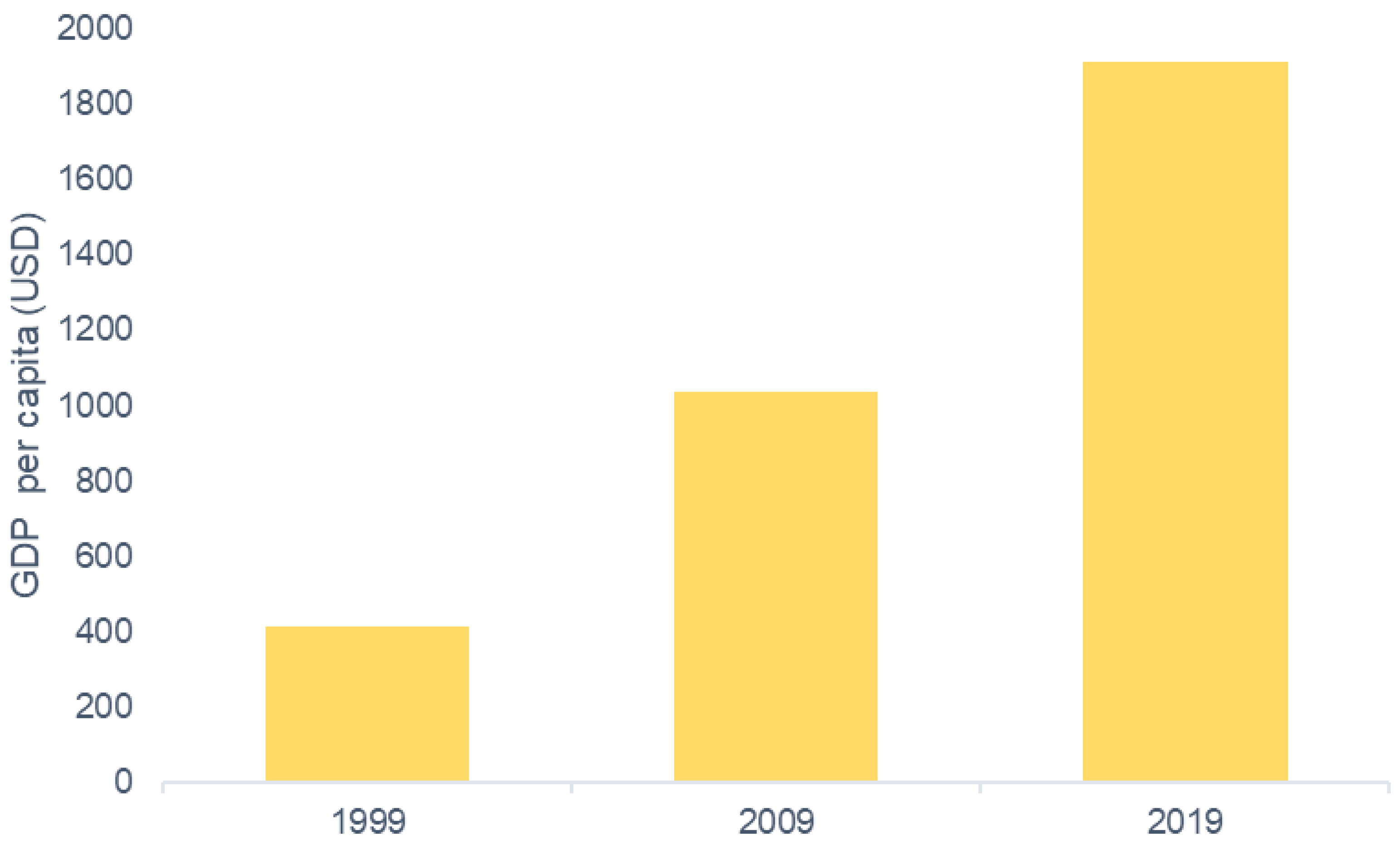
The socio-economic factors considered in the study were population growth, urbanisation, and economic development (GDP). The study found that the population and the GDP had increased substantially in the period from 2000 to 2019 (Figure 6 and Figure 7).
The correlation results show that bare land, built-up area, and cropland have a significant positive correlation with both the urban and rural population and GDP per capita. On the other hand, shrub land, grassland and wetland have a significant negative correlation with the rural and urban population, as well as the GDP per capita. Forest has a non-significant positive correlation with the rural and urban population and a negative non-significant correlation with the GDP per capita. Water has a significant positive correlation with the rural and urban populations and a non-significant negative correlation with the GDP per capita. GDP per capita was the greatest driver for the changes in shrub land (negative relationship), grassland (negative relationship) and cropland (positive relationship); the urban population played the greatest role in the changes in the wetland (negative relationship), while the changes in water, bare land and built-up area were highly and positively influenced by the urban population (Table 5).
The study utilised the coefficient of determination to measure the percentage of the changes in the LULC that can be attributed to the selected factors. The results revealed that most of the LULC changes along the corridor can be explained by the three factors. For example, 44% of the changes in cropland can be attributed to the rural population, while 88% and 99% of the changes in cropland could be attributed to the urban population and the GDP per capita, respectively. Approximately 88% of the changes in water bodies can be explained by the rural population, while 98% can be explained by the urban population. The three factors had a significant influence on the changes in the built-up area with 95%, 77% and 57% of the changes being associated with the urban population, GDP per capita, and rural population, respectively. Changes in the forested area cannot be attributed to any of the three factors, given that R2 was less than 0.35 for the three parameters and thus insignificant, even though the rural population had the highest R2 (0.33) (Table 5).

4. Discussion

The study analysed the LULC dynamics and the underlying drivers in the period 2000–2019 in the SGR corridor with a view of providing an evidence base for the evaluation of the social–ecological impacts of the SGR.
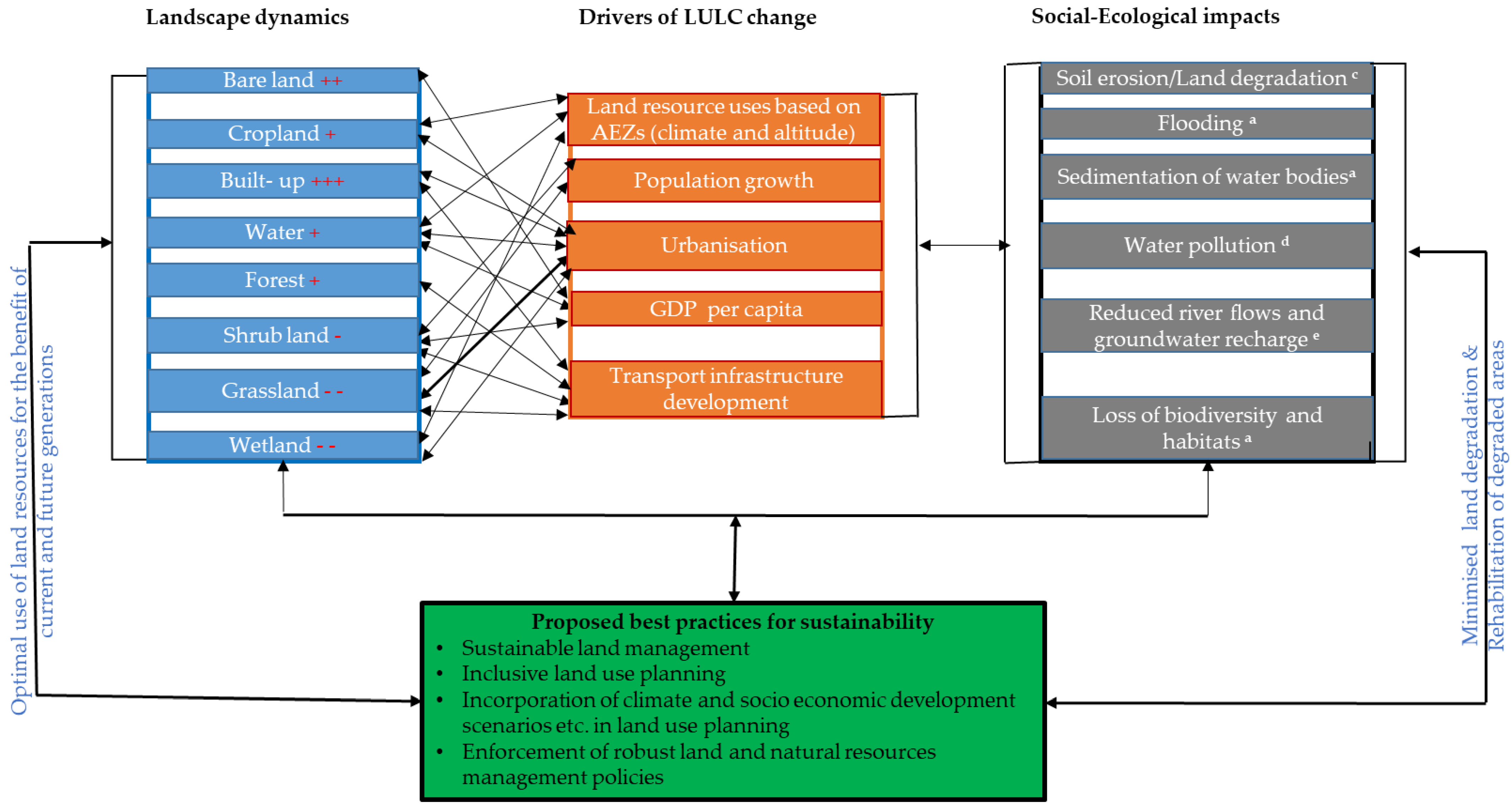
Our results indicate that the corridor has undergone a lot of LULC changes of varying magnitudes, extent, and rates due to numerous underlying factors. The changes have led to several social–ecological impacts, including soil erosion/degradation (localised and severe), e.g., in Kajiado; flooding (localised and low) e.g., in Voi and Narok; sedimentation of water bodies (localised and low), e.g., in Lake Magadi, Kiboko wetlands; water pollution (widespread and low), e.g., in Thange river; the reduced river flows/groundwater recharge (widespread and moderate), e.g., Athi river; loss of biodiversity and habitats (localized and low), e.g., Tsavo and Nairobi national parks.
To address the adverse impacts of the LULC changes and achieve sustainability in the corridor, we propose some of best practices that could offer potential solutions for addressing some of the sustainability challenges linked to large infrastructure developments (Figure 8). Sustainable land management can help in addressing many of the impacts of LULC dynamics such as the degradation of water and soil resources as noted by Branca et al. [55]. Additionally, participatory and inclusive land use planning should be embraced as inclusivity enhances sustainability [56]. Furthermore, future scenarios of climate change, land use change and economic growth should be incorporated into land use planning. Land and natural resource management policies also influence LULC changes, and therefore, robust policies are crucial for sustainable land use [57].

4.1. Changes by LULC Class

Several changes in LULC have occurred over the study period and have been driven by both biophysical and socio-economic factors (Figure 8). In this section, we discuss the changes in each LULC class.
Shrub land and grassland. The substantial loss of vegetation in the SGR corridor is mostly due to the loss of shrub land and grassland because of increased built-up areas (Figure 5a) following urbanisation and population growth [58,59]. Grassland decreased significantly in the lower midland zone, and most of it was replaced by bare land which increased substantially in the same zone. Grassland decreases could be due to land degradation with much of this zone being drylands that are more vulnerable to high surface runoff during the rainy season as well as prolonged, severe droughts during the dry season [60,61,62,63,64]. This agrees with the International Reference and Information Centre (ISRIC) report on global assessment of land degradation which indicated that the potential areas of land degradation were the drylands which include the Eastern region of Kenya [61]. Meanwhile, the grassland reduced in the lower highland zone could be due to encroachment by human settlements and agricultural production [65]. The conversion from grassland to cropland is highly influenced by the GDP as demonstrated by the correlation and regression analyses results. The loss of grassland and shrub land (especially if replaced by built-up or bare land) could lead to increased surface runoff and soil erosion which may contribute to sedimentation and pollution of water bodies resulting in water quantity and quality issues. This also leads to reduced infiltration rates resulting in decreased groundwater recharge.
Forest. The declining forested area in the 2000–2010 period conforms with a report by the Ministry of Environment and Forestry which documents high levels of deforestation in the water towers between 2000 and 2010 with a depletion rate of 5000 hectares p.a. [66]. Deforestation is in part due to inadequate policy enforcement of the protection and conservation of forests and a lack of public awareness of the need to conserve and sustainably use forest resources [66,67]. Additionally, the forests have been encroached on due to the need for more land for agricultural activities to feed the growing population [68,69,70,71] as evidenced by the substantial increase in cropland during the entire study period. The increase in forest cover during the 2010–2019 period can be attributed to Kenya’s efforts to achieve the UN minimum recommended forest area of 10% as stipulated in the Constitution of Kenya 2010 [72], the Forest Act 2016 [73], the Vision 2030 [34] and the National Climate Change Response Strategy [74]. To enhance forest protection, the Forest Act made it more difficult to degazette forests by requiring parliamentary approval rather than regional decisions. Greater community involvement and partnering with other stakeholders for the protection and management of forests have contributed to the increased forest cover in some areas over the same period [66]. Moreover, the evictions of communities from the natural forests such as the Mau Forest complex which started in 2004 and escalated in 2009 [75] and 2018 contributed to some extent to the increase in forested areas in the last decade. Moreover, the changes in forest varied with the AEZ zones where there was an increase in the upper midland and a decrease in both the lower midland and highland zones. More forest was lost in the lower midland than lower highland, and this cannot be linked to the biophysical characteristics of these zones but to population growth, urbanisation and infrastructure development. For example, [6] observed that part of the Kibwezi forest was cleared during the construction of the SGR phase 1. Our results also showed that forests are not significantly impacted directly by the three socio-economic factors considered but indirectly through the impacts of expansion in cropland and built-up areas [29,76]. These findings are in agreement with the findings of a study by [76] who noted that agricultural expansion was the main cause of the highest annual net loss in forest area in the period from 1973 to 1988 in Brazil. In addition, exogenous factors such as complementary policies and area attractiveness are also responsible for changes in forested lands as also noted by [77] in their systematic review of empirical evidence from the USA, Europe, and East Asia on the impacts of transport infrastructure on land use change. Changes in forest cover as documented in many studies often influence the amount of carbon dioxide in the air [78,79]. Similarly, deforestation reduces the removal of carbon dioxide from the air and hence can exacerbate climate change. Deforestation also leads to the loss of biodiversity and habitats, and the degradation of water towers impacting on downstream catchments.
Built-up area. Another notable change was that of built-up area which increased at a rate of 101 km2 p.a., mostly at the expense of shrub land, grassland and agricultural land, especially around the two cities within the corridor (Nairobi and Kisumu). This concurs with the findings of a study done in Ethiopia which reported conversions of other land uses into built-up areas due to an uncontrolled expansion of urban centres [80]. Our results also show a significant correlation between the built-up areas and the urban population growth. Kenya has experienced rapid urbanisation [81], leading to unprecedented pressure on land and other resources [82,83]. According to a report from 2013 by the Republic of Kenya [84], 12.84 million people lived in urban areas in Kenya in 2009, and this has since increased to 14.83 million in 2019 [85], reflecting a high urbanisation growth rate of 8.3% p.a. Urbanisation has been spurred by the devolution of resources over the past two decades, starting with the establishment of the Constituency Development Fund in 2003 [86] and later in 2013 by the implementation of the devolved system of governance, which resulted in greater socio-economic development in the counties [87], more employment opportunities [86], and construction of more buildings (e.g., schools and health facilities) and roads and railways [86,88]. Other related factors include the subdivision of agricultural land and group ranches into small units for settlement, driven by high urban population growth rate, inefficient land use policies [63,64,89] and infrastructure development [6]. We found that GDP contributes highly to a growing proportion of the population living in urban centres, as indicated also by [90]. We noted that built-up areas are influenced more by socioeconomic factors than biophysical factors. Increased built-up areas lead to high surface runoff, reduced infiltration rates, and thus an implication on water resources quantity and quality, and demand—as found by [91,92] who demonstrated a strong relationship between population growth and water demand and quantity.
Cropland. Croplands occupy more than 30% of the area and are found mostly in the western part of the corridor Changes in cropland are influenced by a growing population and the conversion of agricultural land and pasture to settlements [58,59,93], growing food demand [94,95] and improved accessibility to markets [29]. Agricultural expansion is furthermore significantly influenced by economic growth [95,96], and this could be because in a strong economy, people have more resources to invest in agricultural activities, and, on the other hand, the market for agricultural produce improves as the purchasing power of the people increases. Expansion in agriculture has an impact on water demand, biodiversity and the amount of carbon, especially if the increase involves the clearing of forests to create more space for croplands.
Water. The area covered by open water steadily increased between 2000 and 2019, and this resonates with the findings of [97] which reported an increasing trend in surface water in sub-Saharan Africa. This is attributed to several factors, including increased rainfall intensity linked to climate change [74,98], an increase in the precipitation, evaporation ratio, higher runoff due to intensified land uses and degradation, inter-decadal cycles of rainfall variability [99], and increased sedimentation in the Rift Valley lakes displacing water levels upwards and flooding formerly dry areas [100]. Moreover, the results displayed a strong correlation between urbanization and bare land, built-up areas and water, meaning that high urban population growth has had a great impact on the increase in the built-up areas, bare land, and hence increased water levels in the water bodies due to high surface runoff. This differs from the results of other studies; for example, [61] reported a decrease in the surface area of Lake Baringo due to deforestation that led to land degradation and soil erosion, and subsequently the sedimentation of the lake. We also found that the highest increase in water was in the lower highland zone. This could be attributed to the fact that this zone receives the highest amount of rainfall (over 900 mm p.a.). Furthermore, due to increased paved surfaces and loss of vegetation coupled with increased rainfall intensity, especially in Nairobi, Kiambu and Narok, high surface runoff has triggered flash floods leading to sedimentation of water bodies, destruction of property and infrastructure, and loss of lives [101]. Flash floods have also been caused by the confinement of waterways into a common channel, while some natural water channels were blocked and re-directed during the construction of the SGR [6].
Wetland. The wetland area generally declined along the corridor over the study period. This could be because the Rift Valley lake levels have risen since 2010, reaching or exceeding historical highs by 2020 [99], and fringing wetlands may have been covered by rising lake water [100]. Due to the limited water availability in the lower midland zone, the wetlands have been encroached by agricultural activities [102,103,104]. The construction of the SGR also contributed to the depletion of wetlands [6]. For example, the Kiboko wetland was adversely affected by stone quarrying. Meanwhile, in the lower highland zone, the degradation of the water catchment areas led to the loss of wetlands [105]. In terms of socio-economic factors, wetland encroachment for settlement construction has had the biggest impact, as previously observed by [99]. Our results conform with the [106] report which indicates that wetlands have declined and the losses have been driven by an expansion in agriculture, increased population of grazing animals, urban and rural development, as well as infrastructure development, especially in the river valleys and coastal areas. The results of this study show a strong influence of urbanisation on the built-up, water and wetlands. Rapid urban population growth has increased built-up areas leading to high surface runoff and rising water levels which flooded the wetlands. The reduction in wetlands will contribute to loss in biodiversity, habitat, tourism revenue, cultural heritage, and a decrease in water resources—with associated impacts on food security, livelihoods and human well-being.

4.2. Underlying Biophysical and Socio-Economic Drivers

In the SGR corridor, all the natural systems (land use classes) are already stressed from biological disturbances, exploitation, or pollution and are likely to be more sensitive to the impacts of climate change, potentially amplifying the effects of these multiple stressors [107,108]. It is expected that increases in precipitation and temperature extremes will exacerbate the impacts of many landscape-scale stressors on natural capital leading to negative feedback—in agreement with [107,109,110]. This will accelerate impacts on terrestrial, hydrological, and climatic regimes, hence the changes observed in our study area.
As illustrated by the results and the discussion, the many changes in LULC are influenced by both interacting biophysical and socio-economic factors. Climate and altitude (AEZ) play a critical role in the LULC changes. This is evidenced in that our study found that human settlements and agricultural activities are found mostly in areas with a moderate climate, fertile soil, and good terrain. Similarly, forests are found mostly in the highlands with high rainfall while the shrub lands and grasslands dominate the drylands with low elevations (more than 50% of the corridor).
Many studies have shown that socio-economic factors such as population, agricultural expansion, industrialisation, urbanisation, and other forms of economic development have a great impact on land cover dynamics [15,18,111]. We found that all the three socio-economic factors considered (i.e., urbanisation, population, GDP per capita) had impacts of varying magnitudes on the spatial–temporal distribution of LULC. Among the three socio-economic factors, urbanisation had the highest impact on most of the LULC changes in the corridor. Due to rapid industrialisation and other socio-economic activities associated with the urban centres, the corridor has experienced increased rural–urban migration, leading to high urban population growth [59,112], particularly leading to a clear reduction of grassland and shrub land. In the future, the railways and associated infrastructure are expected to increase access to the forests by communities leading to forest degradation [113]. As more feeder roads are developed to increase the accessibility to the railway stations, more forests will be cleared, especially in densely forested areas as noted in other parts of the world [114,115]. The improved accessibility that is anticipated due to the railway construction may result in the conversion of the grasslands, forests and shrub lands into ranches and agricultural fields as established by [29]. Furthermore, given that transport networks often stimulate the development of urban centres in Kenya [80,116], it is likely that highways and other infrastructure will increase in the future—see [117,118].
Many studies have established that landscape dynamics occasioned by LULC change, particularly where natural habitats are converted to agricultural and other uses [119] with adverse social–ecological impacts [120,121]. The findings of this study provide an understanding of the nature, magnitude and underlying drivers of the LULC changes in Kenya, which is crucial for devising and effectively implementing sustainable land management best practices, such as conservation of vulnerable lands, prevention of land conversion, mitigation of land degradation, restoration of degraded lands [122,123], and a basis for more sustainable land use planning [124].
However, higher resolution images would have yielded a more accurate classification of the LULC. Another limitation of the study was that we could not analyse in detail the conversions from one land cover to another, because this requires images of corresponding dates for the three years under study, which was not possible due to the varying quality of the images. Nevertheless, we were able to generally compare the changes using images of the same season—January to March. In addition, the study could not cover the entire SGR phase 1 section because of extensive cloud cover that affected the quality of the images covering most of the coastal region. Although we have some methods for removing clouds using remote sensing software, the accuracy of the results is often compromised. The best solution would be the use of RADAR images which are obtained by active microwave systems and have a capability to penetrate the cloud cover. This was not possible for our study due to financial constraints and unavailability of the RADAR images for the entire study period. Whereas some of the changes in LULC could be linked to climate variability and change, our study did not evaluate the actual impact of the climatic variations on the LULC changes. We, therefore, propose a further study to ascertain the impact of climate variation and change on the LULC dynamics along the corridor.

5. Conclusions

The findings of our study describe land cover dynamics along the SGR corridor between 2000 and 2019. Built-up areas and bare land have increased significantly while the grasslands and wetlands have declined substantially. The major underlying factors that have contributed to these changes are urbanisation, economic development, and agro-ecological factors. Infrastructure development, which is a product of economic growth, influences the growth of urban centres, which, together with population growth, leads to the conversion of croplands, forests, and grasslands into built-up areas, the conversion of forests and grasslands into croplands or settlement areas, or deforestation to meet the material needs of the urban population, for the construction of the railway, or the secondary investments such as roads. The spatial distribution of LULC as well as changes over time vary significantly with Agro-Ecological Zones. In the future, infrastructure development and climate change are expected to accelerate LULC changes along the corridors. The changes in the landscape highlight the need to adequately identify and address the cumulative social and environmental impacts of any mega project and its interacting investments. Future development projects should avoid ecologically sensitive areas, such as national parks and wildlife dispersal areas, water towers and wetlands. Developers should also avoid locating these projects in areas that are favourable for agriculture and human settlements so as not to interfere with the sustainability of local communities’ livelihoods.
Results of this study can be used as a basis for a more detailed evaluation of the impacts of the SGR development and associated projects on natural resources and socio-economic well-being of communities. Findings can provide an evidence base to review the gaps in county land use policies and develop land use plans. LULC should be taken into account when designing and planning more robust, holistic transport corridors to ensure the sustainability of natural resources and delivery of socially inclusive economic growth.

Author Contributions

Conceptualisation, C.C.S. and D.O.O.; methodology, C.C.S.; formal analysis, C.C.S.; investigation, C.C.S., D.O.O. and T.O.N.; resources, D.O.O.; data curation, C.C.S.; writing—original draft preparation, C.C.S.; writing—review and editing, C.C.S., D.O.O., T.O.N., R.M. and J.P.R.T.; supervision, D.O.O. All authors have read and agreed to the published version of the manuscript.

Funding

We acknowledge funding from the UK Research and Innovation’s Global Challenges Research Fund (UKRI GCRF) through the Development Corridors Partnership project (project number: ES/P011500/1).

Data Availability Statement

The authors confirm that the relevant data supporting the findings of this study are available within the article.

Acknowledgments

The authors would like to thank all the stakeholders who contributed to the study.

Conflicts of Interest

The authors declare no conflict of interest.

References

  1. Dewan, A.M.; Yamaguchi, Y. Land use and land cover change in Greater Dhaka, Bangladesh: Using remote sensing to promote sustainable urbanisation. Appl. Geogr. 2009, 29, 390–401. [Google Scholar] [CrossRef]
  2. Li, Y.; Zhu, X.; Sun, X.; Wang, F. Landscape effects of environmental impact on bay-area wetlands under rapid urban expansion and development policy: A case study of Lianyungang, China. Landsc. Urban Plan. 2010, 94, 218–227. [Google Scholar] [CrossRef]
  3. Laurance, W.F.; Sloan, S.; Weng, L.; Sayer, J.A. Estimating the environmental costs of Africa’s massive “development corridors”. Curr. Biol. 2015, 25, 3202–3208. [Google Scholar] [CrossRef] [PubMed] [Green Version]
  4. Alamgir, M.; Campbell, M.J.; Sloan, S.; Goosem, M.; Clements, G.R.; Mahmoud, M.I.; Laurance, W.F. Economic, socio-political and environmental risks of road development in the tropics. Curr. Biol. 2017, 27, R1130–R1140. [Google Scholar] [CrossRef] [Green Version]
  5. DCP Kenya. Development Corridors in Kenya—A Scoping Study; A Country Report of the Development Corridors Partnership (DCP); Institute for Climate Change and Adaptation (ICCA) the University of Nairobi and African Conservation Centre (ACC): Nairobi, Kenya, 2019; Available online: https://developmentcorridors.org/wp-content/uploads/2019/02/Development-Corridors-in-Kenya_Scoping-Report-2019.pdf (accessed on 22 March 2021).
  6. Nyumba, T.O.; Sang, C.C.; Olago, D.O.; Marchant, R.; Waruingi, L.; Githiora, Y.; Kago, F.; Mwangi, M.; Owira, G.; Barasa, R.; et al. Assessing the ecological impacts of transportation infrastructure development: A reconnaissance study of the Standard Gauge Railway in Kenya. PLoS ONE 2021, 16, e0246248. [Google Scholar] [CrossRef]
  7. Damarad, T. Habitat Fragmentation Due to Transportation Infrastructure: Findings of the COST Action 341; Office for Official Publications of the European Communities: Luxembourg, 2003; Available online: https://www.iene.info/content/uploads/2013/10/COST341_final_report.pdf (accessed on 2 February 2021).
  8. Jaeger, J.A.; Bertiller, R.; Schwick, C.; Müller, K.; Steinmeier, C.; Ewald, K.C.; Ghazoul, J. Implementing landscape fragmentation as an indicator in the Swiss Monitoring System of Sustainable Development (Monet). J. Environ. Manag. 2008, 88, 737–751. [Google Scholar] [CrossRef]
  9. Redwood, J. Managing the Environmental and Social Impacts of Major Road Investments in Frontier Regions: Lessons from the Inter-American Development Bank’s Experience; Inter-American Development Bank: Washington, DC, USA, 2012; Available online: https://publications.iadb.org/en/managing-environmental-and-social-impacts-major-road-investments-frontier-regions-lessons-inter (accessed on 13 December 2021).
  10. Perz, S.G.; Qiu, Y.; Xia, Y.; Southworth, J.; Sun, J.; Marsik, M.; Rocha, K.; Passos, V.; Rojas, D.; Alarcón, G.; et al. Trans-boundary infrastructure and land cover change: Highway paving and community-level deforestation in a tri-national frontier in the Amazon. Land Use Policy 2013, 34, 27–41. [Google Scholar] [CrossRef]
  11. Naboureh, A.; Bian, J.; Lei, G.; Li, A. A review of land use/land cover change mapping in the China-Central Asia-West Asia economic corridor countries. Big Earth Data 2021, 5, 237–257. [Google Scholar] [CrossRef]
  12. Hota, S.; Mishra, V.; Mourya, K.K.; Giri, K.; Kumar, D.; Jha, P.K.; Saikia, U.S.; Prasad, P.V.V.; Ray, S.K. Land Use, Landform, and Soil Management as Determinants of Soil Physicochemical Properties and Microbial Abundance of Lower Brahmaputra Valley, India. Sustainability 2022, 14, 2241. [Google Scholar] [CrossRef]
  13. Shukla, A.K.; Ojha CS, P.; Mijic, A.; Buytaert, W.; Pathak, S.; Garg, R.D.; Shukla, S. Population growth, land use and land cover transformations, and water quality nexus in the Upper Ganga River Basin. Hydrol. Earth Syst. Sci. 2018, 22, 4745–4770. [Google Scholar] [CrossRef] [Green Version]
  14. Hope, A.; Cox, J.; Development Corridors. Coffey International Development. 2015. Available online: https://assets.publishing.service.gov.uk/media/57a08995e5274a31e000016a/Topic_Guide_Development_Corridors.pdf (accessed on 8 January 2021).
  15. Hassan, Z.; Shabbir, R.; Ahmad, S.S.; Malik, A.H.; Aziz, N.; Butt, A.; Erum, S. Dynamics of land use and land cover change (LULCCC) using geospatial techniques: A case study of Islamabad Pakistan. SpringerPlus 2016, 5, 812. [Google Scholar] [CrossRef] [PubMed] [Green Version]
  16. Zander, P.; Kächele, H. Modelling multiple objectives of land use for sustainable development. Agric. Syst. 1999, 59, 311–325. [Google Scholar] [CrossRef]
  17. Thinh, N.X.; Arlt, G.; Heber, B.; Hennersdorf, J.; Lehmann, I. Evaluation of urban land-use structures with a view to sustainable development. Environ. Impact Assess. Rev. 2002, 22, 475–492. [Google Scholar] [CrossRef]
  18. Fayaz, A.; Ul Shafiq, M.; Singh, H.; Ahmed, P. Assessment of spatiotemporal changes in land use/land cover of North Kashmir Himalayas from 1992 to 2018. Model. Earth Syst. Environ. 2020, 6, 1189–1200. [Google Scholar] [CrossRef]
  19. Li, X.Y.; Ma, Y.J.; Xu, H.Y.; Wang, J.H.; Zhang, D.S. Impact of land use and land cover change on environmental degradation in Lake Qinghai watershed, northeast Qinghai—Tibet Plateau. Land Degrad. Dev. 2009, 20, 69–83. [Google Scholar] [CrossRef]
  20. Scanlon, B.R.; Jolly, I.; Sophocleous, M.; Zhang, L. Global impacts of conversions from natural to agricultural ecosystems on water resources: Quantity versus quality. Water Resour. Res. 2007, 43, W03437. [Google Scholar] [CrossRef] [Green Version]
  21. Putro, B.; Kjeldsen, T.R.; Hutchins, M.G.; Miller, J. An empirical investigation of climate and land-use effects on water quantity and quality in two urbanising catchments in the southern United Kingdom. Sci. Total Environ. 2016, 548, 164–172. [Google Scholar] [CrossRef] [Green Version]
  22. Khoi, D.N.; Nguyen, V.T.; Sam, T.T.; Nhi, P.T.T. Evaluation on Effects of Climate and Land-Use Changes on Streamflow and Water Quality in the La Buong River Basin, Southern Vietnam. Sustainability 2019, 11, 7221. [Google Scholar] [CrossRef] [Green Version]
  23. Williams, M.; Hopkinson, C.; Rastetter, E.; Vallino, J.; Claessens, L. Relationships of land use and stream solute concentrations in the Ipswich River basin, northeastern Massachusetts. Water Air Soil Pollut. 2005, 161, 55–74. [Google Scholar] [CrossRef]
  24. Schoonover, J.E.; Lockaby, B.G.; Pan, S. Changes in chemical and physical properties of stream water across an urban-rural gradient in western Georgia. Urban Ecosyst. 2005, 8, 107–124. [Google Scholar] [CrossRef]
  25. Tu, W.F.; Lin, J.D.; Wu, Y.L. An analysis of extinction coefficients of particles and water moisture in the stack after flue gas desulfurisation at a coal-fired power plant. J. Air Waste Manag. Assoc. 2011, 61, 815–825. [Google Scholar] [CrossRef] [PubMed] [Green Version]
  26. Li, L.L.; Zhang, Y.Z.; Tang, C.Y.; Zheng, L.; Meng, W.; Lu, S.Y.; Dun, Y. Modeling of Water Quality Response to Land-use Patterns in Taizi River Basin Based on Partial Least Squares. Huanjing Kexue 2017, 38, 1376–1383. [Google Scholar] [PubMed]
  27. Yamazaki, Y.; Muneoka, T.; Okazawa, H.; Kimura, M.; Tsuji, O. Evaluation of river water quality with multivariate analysis in clear stream watersheds in agricultural area. J. Water Environ. Technol. 2017, 15, 86–95. [Google Scholar] [CrossRef] [Green Version]
  28. Chen, D.; Elhadj, A.; Xu, H.; Xu, X.; Qiao, Z. A Study on the Relationship between Land Use Change and Water Quality of the Mitidja Watershed in Algeria based on GIS and RS. Sustainability 2020, 12, 3510. [Google Scholar] [CrossRef]
  29. Msofe, N.K.; Sheng, L.; Lyimo, J. Land use change trends and their driving forces in the Kilombero Valley Floodplain, Southeastern Tanzania. Sustainability 2019, 11, 505. [Google Scholar] [CrossRef] [Green Version]
  30. Sloan, S.; Campbell, M.J.; Alamgir, M.; Engert, J.; Ishida, F.Y.; Senn, N.; Huther, J.; Laurance, W.F. Hidden challenges for conservation and development along the Trans-Papuan economic corridor. Environ. Sci. Policy 2019, 92, 98–106. [Google Scholar] [CrossRef]
  31. Soares-Filho, B.; Alencar, A.; Nepstad, D.; Cerqueira, G.; Vera Diaz, M.D.; Rivero, S.; Solórzano, L.; Voll, E. Simulating the response of land—cover changes to road paving and governance along a major Amazon highway: The Santarém–Cuiabá corridor. Glob. Chang. Biol. 2004, 10, 745–764. [Google Scholar] [CrossRef]
  32. Dong, S.; Li, Y.; Li, Y.; Li, S. Spatiotemporal patterns and drivers of land use and land cover change in the China-Mongolia-Russia economic corridor. Pol. J. Environ. Stud. 2021, 30, 2527–2541. [Google Scholar] [CrossRef]
  33. GOK. Kenya, Vision 2030. 2007. Available online: http://vision2030.go.ke/wp-content/uploads/2018/05/Vision-2030-Popular-Version.pdf (accessed on 28 June 2020).
  34. Government of Kenya. Sessional paper No. 10 of 2012 On Kenya Vision 2030. Government of Kenya—2012—Government Printers Nairobi. 2012. Available online: http://www.foresightfordevelopment.org/sobipro/54/1263-sessional-paper-no-10-of-2012-on-kenya-vision-2030#:~:text=Kenya%20Vision%202030%20is%20the,quality%20of%20life%20by%202030%E2%80%9D (accessed on 15 April 2021).
  35. Laurance, W.F.; Goosem, M.; Laurance, S.G. Impacts of roads and linear clearings on tropical forests. Trends Ecol. Evol. 2009, 24, 659–669. [Google Scholar] [CrossRef]
  36. Su, S.; Xiao, R.; Li, D. Impacts of transportation routes on landscape diversity: A comparison of different route types and their combined effects. Environ. Manag. 2014, 53, 636–647. [Google Scholar] [CrossRef]
  37. Wilkie, D.S.; Finn, J.T.; Finn, J. Remote Sensing Imagery for Natural Resources Monitoring: A Guide for First-Time Users; Columbia University Press: New York, NY, USA, 1996. [Google Scholar]
  38. Otuoma, J. The Effects of Wildlife-Livestock-Human Interactions on Habitat in the Meru Conservation Area, Kenya; LUCID Working Paper, No. 39; ILRI: Nairobi, Kenya, 2004; Available online: https://hdl.handle.net/10568/1905 (accessed on 6 March 2022).
  39. Ahmad, A.; Quegan, S. Analysis of maximum likelihood classification on multispectral data. Appl. Math. Sci. 2012, 6, 6425–6436. [Google Scholar]
  40. Anderson, J.R.; Hardy, E.E.; Roach, J.T.; Witmer, R.E. A Land Use and Land Cover Classification System for use with Remote Sensor Data; US Government Printing Office: Washington, DC, USA, 1976; Volume 964. [Google Scholar] [CrossRef] [Green Version]
  41. Anand, A. Unit-14 Accuracy Assessment; IGNOU: New Delhi, India, 2017; Available online: http://egyankosh.ac.in//handle/123456789/39544 (accessed on 5 May 2021).
  42. Hardin, P.J.; Shumway, J.M. Statistical significance and normalised confusion matrices. Photogramm. Eng. Remote Sens. 1997, 63, 735–739. [Google Scholar]
  43. Lewis, H.G.; Brown, M. A generalised confusion matrix for assessing area estimates from remotely sensed data. Int. J. Remote Sens. 2001, 22, 3223–3235. [Google Scholar] [CrossRef]
  44. Sarkar, A. Accuracy Assessment and Analysis of Land Use Land Cover Change Using Geoinformatics Technique in Raniganj Coalfield Area, India. Int. J. Environ. Sci. Nat. Resour. 2018, 11, 25–34. [Google Scholar]
  45. Carletta, J. Assessing agreement on classification tasks: The kappa statistic. Comput. Linguist. 1996, 22, 249–254. [Google Scholar]
  46. Viera, A.J.; Garrett, J.M. Understanding interobserver agreement: The kappa statistic. Fam Med. 2005, 37, 360–363. [Google Scholar]
  47. Foody, G.M.; Boyd, D.S.; Sanchez-Hernandez, C. Mapping a specific class with an ensemble of classifiers. Int. J. Remote Sens. 2007, 28, 1733–1746. [Google Scholar] [CrossRef]
  48. Lu, D.; Weng, Q. A survey of image classification methods and techniques for improving classification performance. Int. J. Remote Sens. 2007, 28, 823–870. [Google Scholar] [CrossRef]
  49. Martinis, S.; Kersten, J.; Twele, A. A fully automated TerraSAR-X based flood service. ISPRS J. Photogramm. Remote Sens. 2015, 104, 203–212. [Google Scholar] [CrossRef]
  50. Lu, A.; Kang, S.; Li, Z.; Theakstone, W.H. Altitude effects of climatic variation on Tibetan Plateau and its vicinities. J. Earth Sci. 2010, 21, 189–198. [Google Scholar] [CrossRef]
  51. FAO. Agro-Ecological Zoning; Guidelines: FAO Soils Bulletin 73, 78p; Soil Resources, Management and Conservation Service, FAO Land and Water Development Division; Food and Agriculture Organization of the United Nations: Rome, Italy, 1996; ISBN 92-5-103890-2. [Google Scholar]
  52. The World Bank Group. World Bank National Accounts Data, and OECD National Accounts Data Files. 2021. Available online: https://data.worldbank.org/indicator/NY.GDP.MKTP.CD?locations=KE (accessed on 5 May 2021).
  53. Satterthwaite, D.; McGranahan, G.; Tacoli, C. Urbanisation and its implications for food and farming. Philos. Trans. R. Soc. B Biol. Sci. 2010, 365, 2809–2820. [Google Scholar] [CrossRef] [PubMed]
  54. Destek, M.A.; Ozsoy, F.N. Relationships between economic growth, energy consumption, globalisation, urbanisation, and environmental degradation in Turkey. Int. J. Energy Stat. 2015, 3, 1550017. [Google Scholar] [CrossRef]
  55. Branca, G.; Lipper, L.; McCarthy, N.; Jolejole, M.C. Food security, climate change, and sustainable land man-agement. A review. Agron. Sustain. Dev. 2013, 33, 635–650. [Google Scholar] [CrossRef] [Green Version]
  56. Tandon, B.B.; Garg, A. Inclusivity and Sustainable Development. Indian J. Public Adm. 2009, 55, 882–891. [Google Scholar] [CrossRef]
  57. Qian, J.; Peng, Y.; Luo, C.; Wu, C.; Du, Q. Urban land expansion and sustainable land use policy in Shenzhen: A case study of China’s rapid urbanization. Sustainability 2015, 8, 16. [Google Scholar] [CrossRef] [Green Version]
  58. Musa, M.K.; Odera, P.A. Land Use Land Cover Changes and their Effects on Agricultural Land: A Case Study of Kiambu County Kenya. Kabarak J. Res. Innov. 2015, 3, 74–86. [Google Scholar]
  59. Wandaka, J.K.; Francis, K.M. Analysis of Impacts of Land Use Changes in Kitengela Conservation Area on Migratory Wildlife of Nairobi National Park, Kenya. Int. J. Appl. Sci. 2019, 2, 41. [Google Scholar] [CrossRef] [Green Version]
  60. Bai, Z.G.; Dent, D.L. Global Assessment of Land Degradation and Improvement: Pilot Study in Kenya. Report 2006/01, ISRIC-World Soil Information, Wageningen. 2006. Available online: https://www.isric.org/sites/default/files/isric_report_2006_01.pdf (accessed on 24 September 2021).
  61. Kiage, L.M.; Liu, K.B.; Walker, N.D.; Lam, N.; Huh, O.K. Recent land-cover/use change associated with land degradation in the Lake Baringo catchment, Kenya, East Africa: Evidence from Landsat TM and ETM+. Int. J. Remote Sens. 2007, 28, 4285–4309. [Google Scholar] [CrossRef]
  62. Kiage, L.M.; Liu, K.B. Palynological evidence of climate change and land degradation in the Lake Baringo area, Kenya, East Africa, since AD 1650. Palaeogeogr. Palaeoclimatol. Palaeoecol. 2009, 279, 60–72. [Google Scholar] [CrossRef]
  63. Mulinge, W.; Gicheru, P.; Murithi, F.; Maingi, P.; Kihiu, E.; Kirui, O.K.; Mirzabaev, A. Economics of land degradation and improvement in Kenya. In Economics of Land Degradation and Improvement—A Global Assessment for Sustainable Development; Springer: Cham, Switzerlands, 2016; pp. 471–498. [Google Scholar]
  64. Gichenje, H.; Godinho, S. A climate-smart approach to the implementation of land degradation neutrality within a water catchment area in Kenya. Climate 2019, 7, 136. [Google Scholar] [CrossRef] [Green Version]
  65. Olang, L.O.; Kundu, P.M. Land degradation of the Mau forest complex in Eastern Africa: A review for management and restoration planning. Environ. Monit. 2011, 528, 245–262. [Google Scholar]
  66. ROK. Taskforce Report on Forest Resources Management and Logging Activities in Kenya. 2018. Available online: http://www.environment.go.ke/wp-content/uploads/2018/08/Forest-Report.pdf (accessed on 26 September 2021).
  67. Juma, R.A. The Socio-Economic Impact of Deforestation and Eviction: A Study of the Ogiek Community of the Mau Forest, Kenya. Ph.D. Thesis, University of Nairobi, Nairobi, Kenya, 2012. [Google Scholar]
  68. Benjamin, F.R., Jr.; Barry, N. Haack. Deforestation in Kenya. J. Geogr. 1982, 81, 151. [Google Scholar] [CrossRef]
  69. DeFries, R.S.; Rudel, T.; Uriarte, M.; Hansen, M. Deforestation driven by urban population growth and agricultural trade in the twenty-first century. Nat. Geosci. 2010, 3, 178–181. [Google Scholar] [CrossRef]
  70. Erb, K.H.; Lauk, C.; Kastner, T.; Mayer, A.; Theurl, M.C.; Haberl, H. Exploring the biophysical option space for feeding the world without deforestation. Nat. Commun. 2016, 7, 11382. [Google Scholar] [CrossRef] [Green Version]
  71. Albertazzi, S.; Bini, V.; Lindon, A.; Trivellini, G. Relations of power driving tropical deforestation: A case study from the Mau Forest (Kenya). Belg. Rev. Belg. Géographie 2018, 2. [Google Scholar] [CrossRef]
  72. ROK. Constitution of Kenya. 2010. Available online: http://www.kenyalaw.org:8181/exist/kenyalex/actview.xql?actid=Const2010 (accessed on 3 November 2021).
  73. Rok. The Forest Conservation and Management Act, 2016. No. 34 of 2016. 2016. Available online: http://kenyalaw.org/kl/fileadmin/pdfdownloads/Acts/ForestConservationandManagementActNo34of2016.pdf (accessed on 2 March 2022).
  74. GOK. National Climate Change Response Strategy. Executive Brief. 2010. Available online: http://www.environment.go.ke/wp-content/documents/complete%20nccrs%20executive%20brief.pdf (accessed on 3 December 2021).
  75. Klopp, J.M.; Sang, J.K. Maps, power, and the destruction of the Mau Forest in Kenya. Georgetown J. Int. Aff. 2011, 12, 125–134. [Google Scholar]
  76. de Moraes MC, P.; de Mello, K.; Toppa, R.H. Protected areas and agricultural expansion: Biodiversity conservation versus economic growth in the Southeast of Brazil. J. Environ. Manag. 2017, 188, 73–84. [Google Scholar] [CrossRef]
  77. Kasraian, D.; Maat, K.; Stead, D.; van Wee, B. Long-term impacts of transport infrastructure networks on land-use change: An international review of empirical studies. Transp. Rev. 2016, 36, 772–792. [Google Scholar] [CrossRef]
  78. Gorte, R.W.; Sheikh, P.A. Deforestation and Climate Change. 2010. Available online: https://www.files.ethz.ch/isn/115286/140767.pdf (accessed on 25 July 2021).
  79. Longobardi, P.; Montenegro, A.; Beltrami, H.; Eby, M. Deforestation induced climate change: Effects of spatial scale. PLoS ONE 2016, 11, e0153357. [Google Scholar] [CrossRef]
  80. Fitawok, M.B.; Derudder, B.; Minale, A.S.; Van Passel, S.; Adgo, E.; Nyssen, J. Modeling the impact of urbanization on land-use change in Bahir Dar City, Ethiopia: An integrated cellular Automata–Markov Chain Approach. Land 2020, 9, 115. [Google Scholar] [CrossRef] [Green Version]
  81. Güneralp, B.; Lwasa, S.; Masundire, H.; Parnell, S.; Seto, K.C. Urbanisation in Africa: Challenges and opportunities for conservation. Environ. Res. Lett. 2017, 13, 015002. [Google Scholar] [CrossRef]
  82. Mundia, C.N.; Aniya, M. Analysis of land use/cover changes and urban expansion of Nairobi city using remote sensing and GIS. Int. J. Remote Sens. 2005, 26, 2831–2849. [Google Scholar] [CrossRef]
  83. Rok. National Report on Settlements and the New Urban Agenda towards Habitat III. 2016. Available online: http://habitat3.org/wp-content/uploads/Kenya-National-Report.pdf (accessed on 12 August 2020).
  84. ROK. Kenya Population Situation Analysis. Kenyan Government, Nairobi, 2013. Available online: https://www.unfpa.org/sites/default/files/admin-resource/FINALPSAREPORT_0.pdf (accessed on 23 June 2020).
  85. KNBS. Kenya Population and Housing Census. 2019. Available online: https://www.knbs.or.ke/ (accessed on 23 June 2020).
  86. Auya, S.; Oino, P. The role of constituency development fund in rural development: Experiences from North Mugirango Constituency, Kenya. Int. J. Sci. Res. 2013, 2, 306–312. [Google Scholar]
  87. Njuguna, C. Devolution and Its Effect on the Community: A Cross Sectional Study of Githunguri Constituency in Kiambu County. Ph.D. Thesis, University of Nairobi, Nairobi, Kenya, 2016. [Google Scholar]
  88. Ntara, C. Devolution and expected impact in Kenya. Int. J. Prof. Pract. 2013, 4, 7–14. [Google Scholar]
  89. Kithiia, S.M. An assessment of water quality changes within the Athi and Nairobi river basins during the last decade. IAHS Publ. 2007, 314, 205. [Google Scholar]
  90. Deng, X.; Huang, J.; Rozelle, S.; Uchida, E. Economic growth and the expansion of urban land in China. Urban Stud. 2010, 47, 813–843. [Google Scholar] [CrossRef]
  91. Liu, Y.; Chen, Y. Impact of population growth and land-use change on water resources and ecosystems of the arid Tarim River Basin in Western China. Int. J. Sustain. Dev. World Ecol. 2006, 13, 295–305. [Google Scholar] [CrossRef]
  92. Ray, S.; Ray, I.A. Impact of population growth on environmental degradation: Case of India. J. Econ. Sustain. Dev. 2011, 2, 72–77. [Google Scholar]
  93. Thuo, A.D.M. Impacts of urbanisation on land use planning, livelihood and environment in the Nairobi rural-urban fringe, Kenya. Int. J. Sci. Technol. Res. 2013, 2, 70–79. [Google Scholar]
  94. Nwokoro, C., II; Dekolo, S.O. Land use change and environmental sustainability: The case of Lagos Metropolis. Sustain. City VII Urban Regen. Sustain. 2012, 1, 157–167. [Google Scholar]
  95. Jiang, L.; Deng, X.; Seto, K. CThe impact of urban expansion on agricultural land use intensity in China. Land Use Policy 2013, 35, 33–39. [Google Scholar] [CrossRef]
  96. Coxhead, I.; Shively, G.; Shuai, X. Development policies, resource constraints, and agricultural expansion on the Philippine land frontier. Environ. Dev. Econ. 2002, 7, 341–363. [Google Scholar] [CrossRef] [Green Version]
  97. United Nations Environment Programme. Progress on Freshwater Ecosystems: Tracking SDG 6 Series—Global Indicator 6.6.1 Updates and Acceleration Needs. 2021. Available online: https://wedocs.unep.org/bitstream/handle/20.500.11822/36691/PFE6.6.1.pdf?sequence=3&isAllowed=y (accessed on 6 November 2021).
  98. Kiage, L.M.; Douglas, P. Linkages between land cover change, lake shrinkage, and sublacustrine influence determined from remote sensing of select Rift Valley Lakes in Kenya. Sci. Total Environ. 2020, 709, 136022. [Google Scholar] [CrossRef]
  99. Olago, D.O.; Raini, J.; Omuombo, C.; Ogonda, G.; Muli, J.; Okello, C.; Ong’ang’a, O. Lentic-Lotic Water System Response to Anthropogenic and Climatic Factors in Kenya and Their Sustainable Management. In Climate Change and Water Resources in Africa; Springer: Cham, Switzerland, 2021; pp. 193–218. [Google Scholar]
  100. Sean, A. Scientists are Worried about the Impact of Kenya’s Rift Valley Lakes Flooding. 2020. Available online: https://qz.com/africa/1918674/scientists-worried-by-flooding-in-kenya-rift-valley-lakes/ (accessed on 12 February 2021).
  101. Abuje, S.J.; Otoki, B.M.; Njuguna, B.M.; Munala, G. The Vulnerability of Nairobi to the Effects of Climate Change between 1984 and 2016. Landsc. Archit. Reg. Plan. 2020, 5, 38. [Google Scholar]
  102. Mohamed, M.A. Mitigating the Effects of Intensive Agriculture on Wetlands: The Case of Saiwa Wetlands, Kenya. 2002. Available online: https://aquadocs.org/handle/1834/7384 (accessed on 3 March 2022).
  103. Rongoei, P.J.K.; Kipkemboi, J.; Okeyo-Owuor, J.B.; Van Dam, A.A. Ecosystem services and drivers of change in Nyando floodplain wetland, Kenya. Afr. J. Environ. Sci. Technol. 2013, 7, 274–291. [Google Scholar]
  104. Kibet, R.; Olatubara, C.O.; Ikporukpo, C.O.; Jebiwott, A. Land Use Land Cover Changes and Encroachment Issues in Kapkatet Wetland, Kenya. Open J. Ecol. 2021, 11, 493–506. [Google Scholar] [CrossRef]
  105. Macharia, J.M.; Thenya, T.; Ndiritu, G.G. Management of highland wetlands in central Kenya: The importance of community education, awareness and eco-tourism in biodiversity conservation. Biodiversity 2010, 11, 85–90. [Google Scholar] [CrossRef]
  106. Ramsar Convention on Wetlands. Ramsar Fact Sheet 3 Wetlands: A Global Disappearing Act. 2021. Available online: https://www.ramsar.org/sites/default/files/documents/library/factsheet3_global_disappearing_act_0.pdf (accessed on 6 November 2021).
  107. Staudt, A.; Leidner, A.K.; Howard, J.; Brauman, K.A.; Dukes, J.S.; Hansen, L.J.; Paukert, C.; Sabo, J.; Solórzano, L.A. The added complications of climate change: Understanding and managing biodiversity and ecosystems. Front. Ecol. Environ. 2013, 11, 494–501. [Google Scholar] [CrossRef]
  108. Grimm, N.B.; Chapin, F.S., III; Bierwagen, B.; Gonzalez, P.; Groffman, P.M.; Luo, Y.; Melton, F.; Nadelhoffer, K.; Pairis, A.; Raymond, P.A.; et al. The impacts of climate change on ecosystem structure and function. Front. Ecol. Environ. 2013, 11, 474–482. [Google Scholar] [CrossRef] [Green Version]
  109. Kröpelin, S.T.; Verschuren, D.; Lézine, A.M.; Eggermont, H.; Cocquyt, C.; Francus, P.; Cazet, J.P.; Fagot, M.; Rumes, B.; Russell, J.M.; et al. Climate-driven ecosystem succession in the Sahara: The past 6000 years. Science 2008, 320, 765–768. [Google Scholar] [CrossRef] [Green Version]
  110. McMahon, S.M.; Parker, G.G.; Miller, D.R. Evidence for a recent increase in forest growth. Proc. Natl. Acad. Sci. USA 2010, 107, 3611–3615. [Google Scholar] [CrossRef] [PubMed] [Green Version]
  111. Handavu, F.; Chirwa, P.W.; Syampungani, S. Socio-economic factors influencing land-use and land-cover changes in the miombo woodlands of the Copperbelt province in Zambia. For. Policy Economics 2019, 100, 75–94. [Google Scholar] [CrossRef] [Green Version]
  112. Chege, J.; Ngui, D.; Kimuyu, P. Scoping Paper on Kenyan Manufacturing (No. 2014/136). WIDER Working Paper. 2014. Available online: https://www.wider.unu.edu/sites/default/files/wp2014-136.pdf (accessed on 12 August 2020).
  113. De Luca, G.D. Roads, Development and Deforestation: A Review. Development Research Group Paper. 2017. Available online: https://forestindustries.eu/sites/default/files/userfiles/1file/roads2008.pdf (accessed on 12 August 2020).
  114. Tole, L. Sources of deforestation in tropical developing countries. Environ. Manag. 1998, 22, 19–33. [Google Scholar] [CrossRef]
  115. Baehr, C.; BenYishay, A.; Parks, B. Linking Local Infrastructure Development and Deforestation: Evidence from Satellite and Administrative Data. J. Assoc. Environ. Resour. Econ. 2021, 8, 375–409. [Google Scholar] [CrossRef]
  116. RoK. Sessional Paper No. 3 of 2012 on Population Policy for National Development. 2013. Available online: https://www.ncpd.go.ke/wp-content/uploads/2016/11/Population-Policy-for-National-Development-Final-July-2013.pdf (accessed on 12 August 2020).
  117. Hu, Z.; Lo, C.P. Modeling urban growth in Atlanta using logistic regression. Comput. Environ.t Urban Syst. 2007, 31, 667–688. [Google Scholar] [CrossRef]
  118. Liu, D.; Clarke, K.C.; Chen, N. Integrating spatial nonstationarity into SLEUTH for urban growth modeling: A case study in the Wuhan metropolitan area. Comput. Environ. Urban Syst. 2020, 84, 101545. [Google Scholar] [CrossRef]
  119. Smyth, A.J.; Dumanski, J.; Spendjian, G.; Swift, M.J.; Thornton, P.K. FESLM: An International Framework for Evaluating Sustainable Land Management; FAO: Rome, Italy, 1993; Volume 73. [Google Scholar]
  120. Nejadhashemi, A.P.; Shen, C.; Wardynski, B.J.; Mantha, P.S. Evaluating the impacts of land use changes on hydrologic responses in the agricultural regions of Michigan and Wisconsin. In 2010 Pittsburgh, Pennsylvania, June 20–June 23, 2010; American Society of Agricultural and Biological Engineers: St. Joseph, MI, USA, 2010; p. 1. [Google Scholar]
  121. Gashaw, T.; Tulu, T.; Argaw, M.; Worqlul, A.W. Modelling the hydrological impacts of land use/land cover changes in the Andassa watershed, Blue Nile Basin, Ethiopia. Sci. Total Environ. 2018, 619, 1394–1408. [Google Scholar] [CrossRef]
  122. Bunning, S.; De Pauw, E. Land Resource Planning for Sustainable Land Management. Current and Emerging Needs in Land Resource Planning for Food Security, Sustainable Livelihoods, Integrated Landscape Management and Restoration. Land and Water Division Working Paper (FAO) Eng No. 14. 2017. Available online: https://www.fao.org/3/i5937e/i5937e.pdf (accessed on 7 January 2022).
  123. FAO. Sustainable Land Management. 2022. Available online: https://www.fao.org/land-water/land/sustainable-land-management/slm-practices/en/ (accessed on 7 January 2022).
  124. Santato, S.; Bender, S.; Schaller, M. The European Floods Directive and Opportunities offered by Land Use Planning; CSC Report 12; Climate Service Center: Berlin, Germany, 2013; Available online: https://www.researchgate.net/publication/273274352_The_European_Floods_Directive_and_Opportunities_offered_by_Land_Use_Planning (accessed on 6 March 2022).
Figure 1. Location of the study area showing the SGR line Phase 1 (Miasenyi Station-Athi River); Phase 2A (Athi River-Naivasha Inland Port); Phase 2B (Naivasha Inland Port-Kisumu). Sources: SGR—KRC and WWF—Kenya GIS CoE—2019; AEZs—FAO 1996.
Sustainability 14 06158 g001
Figure 2. SGR corridor land cover for 2000.
Sustainability 14 06158 g002
Figure 3. SGR corridor land cover for 2010.
Sustainability 14 06158 g003
Figure 4. SGR corridor land cover 2019.
Sustainability 14 06158 g004
Figure 5. LULC (a) and the overall LULC change (b) between 2000 and 2019 along the SGR corridor.
Sustainability 14 06158 g005
Figure 6. The rural and urban population along the SGR corridor.
Sustainability 14 06158 g006
Figure 7. The GDP per capita in US$, Kenya.
Sustainability 14 06158 g007
Figure 8. The interactions between the LULC changes, the underlying drivers and impacts of the changes. {+ (<50% increase), ++ (50–100% increase), +++ (>100% increase), − (<50% decrease), −− (50–100% increase)}; {a (localised/low), c (localised/severe), d (widespread/low), e (widespread/moderate)}.
Sustainability 14 06158 g008
Table 1. Temperature and rainfall in the AEZs.
Mean Annual TemperatureAnnual Rainfall
SubhumidSemi-HumidSemi-AridArid
Lower midland21 °C–24 °C>1000 mm900–1800 mm300–600 mm200–400 mm
Upper midland18 °C–21 °C>1000 mm900–1800 mm300–600 mm200–400 mm
Lower highland15 °C–18 °C>1000 mm900–1800 mm300–600 mm200–400 mm
Source: FAO (1996).
Table 2. Land Use and Land Cover in the lower midland AEZs along the SGR corridor.
Land Use Land CoverLand Use Land Cover Change
LULC2000201020192000–20102010–20192000–2019
km2%km2%km2%km2%km2%km2%
Bare land42310.5166016.4086121.4023756.0320130.45438103.55
Built-up360.89812.01761.8945125.00−5−6.1740111.11
Cropland125031.06124730.99125831.26−3−0.24110.8880.64
Forest1513.751122.78942.34−39−25.83−18−16.07−57−37.75
Grassland2255.59761.89992.46−149−66.222330.26−126−56.00
Shrub land182645.38180344.811608.39.96−23−1.26−195−10.82−218−11.94
Water250.62240.60280.70−1−4.00416.67312.00
Wetland882.19210.520.0.00−67−76.14−21−100.00−88−100.00
Total4024100.004024100.004024100.00------
Table 3. Land use and land cover in the upper midland AEZs along the SGR corridor.
Land Use Land CoverLand Use Land Cover Change
LULC2000201020192000–20102010–20192000–2019
km2%km2%km2%km2%km2%km2%
Bare land69419.1787624.1973820.3818226.22−138−15.75446.34
Built-up1223.371634.502536.994133.619055.21131107.38
Cropland115231.81128935.60122233.7513711.89−67−5.20706.08
Forest742.04621.711062.93−12−16.224470.973243.24
Grassland51214.142667.351664.58−246−48.05−100−37.59−346−67.58
Shrub land103928.6991925.38111230.71−120−11.5519321.00737.03
Water70.19200.55230.6413185.71315.0016228.57
Wetland210.58260.7210.03523.81−25−96.15−20−95.24
Total3621100.003621100.003621100.00------
Table 4. Land Use and Land Cover in the lower highland AEZs along the SGR corridor.
Land Use Land CoverLand Use Land Cover Change
LULC2000201020192000–20102010–20192000–2019
km2%km2%km2%km2%km2%km2%
Bare land864.741488.161206.626272.09−28.−18.923439.53
Built-up160.88382.09281.5422137.50−10−26.3212.75.00
Cropland93251.3895652.70107959.48242.5812312.8714715.77
Forest573.14623.42532.9258.77−9−14.52−4−7.02
Grassland26514.61663.64613.36−199−75.09−5−7.58−204−76.98
Shrub land44424.4852929.1645725.198519.14−72−13.61132.93
Water30.1760.33150.833100.009150.0012400.00
Wetland110.6190.5010.06−2−18.18−8−88.89−10−90.91
Total1814100.001814100.001814100.00------
Table 5. Results of the correlation and regression analysis between LULC and rural population, urban population and the GDP. Tested at 95% confidence level; Correlation is significant when r < −0.6 or r > 0.6; R-squared is significant when R2 > 0.35 (*—Significant).
Rural PopulationUrban PopulationGDP per Capita
LULCR-Squared (R2)Corr. Coeff (r)R-Squared (R2)Corr. Coeff (r)R-Squared (R2)Corr. Coeff (r)
Shrub land0.95 *−0.97 *0.94 *−0.97 *0.98 *−0.99 *
Cropland0.44 *0.67 *0.88 *0.94 *0.99 *1.00 *
Bare land 0.91 *0.95 *0.97 *0.98 *0.75 *0.86 *
Grassland0.47 *−0.68 *0.90 *−0.95 *0.99 *−0.99 *
Forest0.330.570.010.120.05−0.23
Built-up0.57 *0.75 *0.95 *0.97 *0.77 *0.88 *
Wetland0.79 *−0.89 *1.00 *−1.00 *0.91 *−0.95 *
Water0.88 *0.94 *0.98 *0.99 *0.31−0.56
Publisher’s Note: MDPI stays neutral with regard to jurisdictional claims in published maps and institutional affiliations.