Abstract
Recurrent floods have become a major problem in the transboundary Lower Mono River catchment of Togo and Benin, causing more damage and loss of life than any other disaster in the area. The level of understanding about floods and their management can be as diverse as the groups within the communities and thus can present a variety of perspectives. People tend to perceive flood risk and management differently due to their proximity to flood-prone areas and their level of vulnerability as well as their capacity to adapt. Therefore, this study explores the specific perspectives of local communities and experts on floods in the transboundary Mono catchment, which can help to inform better adaptation strategies according to the contexts of each community. We conducted series of focus groups discussions (FGDs) using the Actors, Resources, Dynamics, and Interactions (ARDI) framework to develop mental models of flood management. This approach allowed us to identify the causes and impact of flooding in the area, and to describe the actors and effects of flood events on the main natural resources as well as the dynamics and interactions that drive change and influence flood management in the study area. The results indicate that the perceptions of local communities and experts show both similarities and differences. These differences include (1) perceptions of relevant direct actors, (2) perceptions of resources at stake, and (3) actor-specific resource utilization. Considering these dissimilar views between expert and local community knowledge systems appears to be an important contributing factor to improving flood mitigation efforts in the catchment. Adapting risk communication and measures taken for flood management in accordance with the perceptions of affected communities could greatly increase success, with positive long-term effects for the involved institutions and communities regarding mutual trust-building.
1. Introduction
1.1. Background
Floods are among the most recurrent and devastating natural hazards, severely impacting human and natural systems all over the world [1,2]. According to Mahe et al. [3], major impacts of flood and river regions have been observed in West Africa, where flooding events have not only caused material damage, impacted health, and caused economic losses, but are also responsible for environmental degradation, displacement and homelessness, lack of food and drinking water, interruption of social activities, and lack of mobility [4]. Similarly, in the transboundary Mono River catchment of Togo and Benin, frequent flood events have had devastating effects, resulting in loss of human life, destruction of property, and agricultural losses [5]. Floods deteriorate livelihoods, exposing population to dangers and pushing them to adopt different survival strategies [6].
Floods can be caused by natural factors, such as extreme rainfall events, topography, geological features, or deforestation [7]. Descroix et al. [8] summarized the multidecadal evolution of hydrological processes in West Africa, finding that floods are significantly linked to climate and land-use changes. Similarly, Thiam et al. [9] depicted the future land-use pattern in the Mono River catchment (deforestation and city growth), which could worsen the expansion of flood areas in the catchment. Indeed, the conversion of forest to farmland can influence runoff and soil water retention, resulting in devastating flooding [10]. Moreover, projected climate change scenarios in the study area showed a significant trend of changing rainfall patterns, which will increase the mean and peak river flows and could cause serious flooding [11,12,13]. On the other hand, anthropic action is not without consequences regarding the occurrence and/or frequency of floods. Agricultural, infrastructural, and urbanization developments, as well as lack of maintenance of watercourses and construction in floodplains have great impact on the hydrology of an environment, especially of a watershed [14]. The causes of flooding are, therefore, particularly complex. Most households describe flooding based on available information and their experiences. As a result, the description of floods will vary according to the social habits of individuals and their priorities and capacities during flooding [15]. Therefore, it is important to understand how households perceive flood causes and how flooding affects their livelihoods as well as the natural resources in order to implement effective adaptation strategies for flood management at the scientific and political level. Indeed, in recent years, the perception of flood risk has become an important topic for policy makers concerned about risk management and safety issues [16]. It has aided in developing successful policy responses to floods and other disasters [17]. In addition, the perceived knowledge of households may also provide important information about a population’s vulnerability and capacity to adapt to floods as well as their willingness to take preventives actions [18]. This might be important for developing communication strategies regarding flood risk and motivating people to implement flood-reduction measures [19,20].
Generally, “risk” is defined as the potential consequences of a hazard [21]. Risk perception is defined as an assessment of the probability of hazard and the probability of the results (most often the negative consequences) perceived by society [22,23,24]. Flood risk perception is defined as a combination of three specific factors of risk—awareness, worry, and preparedness [25].
Flood risk management requires a careful combination of individual, community, and national action at all scales [21]. In the Mono River, various flood management initiatives have been implemented for minimizing flood impacts. However, most of these actions do not always coincide with people’s perceptions and understanding of flood risk; as a result, implementing flood adaptation strategies might become challenging and insufficient for people, which could explain why only certain measures are adopted by communities and others are not. Flood risk is perceived differently based on people’s vulnerability level and capacity to adapt [20,26]. According to Burns and Slovic [27], risk perception is a key element in vulnerability studies, where risk perception and risk-related behaviors can amplify the social, political, and economic impact of disasters far beyond their consequences. How people (households, businesses, governing bodies, etc.) perceive and understand flood risk shapes the decisions they make and the actions they take to prepare for and respond to floods.
In the field of flood risk management, great emphasis is placed on the promotion of information and the activation of a so-called “risk culture” [28,29]. Indeed, sociologists have shown that the perception of risks by institutional actors, scientists, and public authority representatives is different from the social perception of risks by individuals [30,31,32]. When faced with diverse perceptions of actors on flood risk, knowing the differences and similarities between them as well as the factors that influence their adaptive behavior is essential, especially for taking preventive measures against flooding [33]. Moreover, understanding the relationship between actors and resources, and the consequence of their interventions, is important for improving flood management and community resilience to a flood hazard [34]. To the best of our knowledge, there is currently no study on the Mono River catchment that has looked at these diverse perceptions of floods, particularly those of experts and local communities as actors involved in flood management.
The research question of this study is: How do perceptions of flood risk management in the Mono River catchment of local communities differ from those of experts working in this area? In this regard, the main objective of this research is to identify the perceived causes and impact of floods, flood-affected resources, and key actors involved in flood management of the Mono River catchment. To address this, we applied the Actor, Resources, Dynamics, and Interactions (ARDI) method developed by Etienne et al. [35], which aims to encourage participants to describe, explain, and predict the purpose, form, function, and state of a given system [36,37]. ARDI frames the incentive for individual learning, which in turn will lead to the emergence of collective learning [38]. Many studies have applied this method to codevelop conceptual or mental models for natural resources management in both developing and developed countries [37,39,40,41]. Mental models are cognitive representations of external reality that represent how people develop an understanding of causal processes associated with physical or mechanical systems [42,43]. Indeed, codeveloping conceptual models for flood management can provide a collective representation of the system in order to improve decision-making processes [44,45] and enhance social learning and problem-solving [46,47]. This technique helps to determine what individuals already know about flood risks and their responses, as well as any key knowledge gaps that could be filled through better risk communication [48,49].
Mental models are internal representations of the world that allow an individual to interpret observations, organize beliefs, and make decisions in different contexts [42]. Much research has shown that the construction of human risk perception is a complex process [50]. Determining viable strategies for better risk management requires models that appropriately reflect human knowledge systems and learning processes. In learning for a sustainable future, we need to go beyond traditional measures of risk variables and gain a more comprehensive and holistic understanding of risk behavior. Furthermore, individual perceptions of how climate risk is likely to affect them personally often appear to differ from their perceptions of how climate risk is likely to affect society as a whole. It is therefore important to develop better understanding of how individuals construct their knowledge, learn, and ultimately make decisions about climate risk management [50]. Mental models have long been used to analyze how the public uses scientific information and knowledge to develop beliefs about climate risks such as flooding [51]. These beliefs are identified through a process of comparing two archetypal mental models: a layman’s model, in this case a model developed by the local population, and an expert’s model [52]. Both models are constructed and reinforced by experience and social interaction; thus, lay models tend to be more practical, limited by the amount of time and attention they can give to a task, while expert models tend to be more theoretical or scientific, and thus more complex and systemic [53]. Comparing these two models helps to identify critical gaps in understanding between the two groups and to focus communication and awareness on the most relevant and meaningful information that individuals need [48,54]. Comparing expert and local community perspectives will also contribute to fill in knowledge gaps and promote two-way communication [55].
1.2. ARDI Approach
The ARDI process proposes to help imagine more open, dynamic management, capable of adaptation and anticipation, by bringing together different stakeholders in a partnership, contributing to the preservation of natural resources through sustainable management based on correct scientific foundations and real cultural creativity. Its originality lies in co-constructing a “conceptual model” of the functioning of the territory [35].
The ARDI method was developed and described in detail by Etienne et al. [35] and has been used in many studies to codevelop mental models both in developing and developed countries [37,39,40,41,56,57,58]. It has been applied for developing collaborative vision, revealing drivers of a system, and prioritizing resource allocation as a basis for participatory modeling in natural resource management [57,59]. It was used by Villamor et al. [39] to compare scientist and local stakeholder perceptions of food–energy–water systems (FEWS) in the Magic Valley, Southern Idaho, and found apparent differences between the two groups. It enabled the incorporation of different perspectives and types of knowledge into the FEWS models. Etienne et al. [35] managed to show the importance of taking into account the perceptions of all stakeholders with regard to participatory natural resource management. According to Reed [60], stakeholder participation can improve the quality of environmental decisions by taking into account more complete information. In addition, local and scientific knowledge can be integrated to provide more complete understanding of complex and dynamic socio–ecological systems and processes. This knowledge can also be used to assess the suitability of potential technical and local solutions to environmental problems.
In West Africa, the ARDI approach was applied to understand the crop–livestock system and to develop solutions for its effective management in Burkina Faso [61], and to improve a seed management system in Mali [62]. Most of these studies did not concern disaster risk management, such as flood mitigation. For example, several studies highlighted the need for flood management in the Mono catchment area in Togo and Benin [5,63,64,65]; however, the application of ARDI to capture the various perceptions of local experts and communities remained missing.
2. Materials and Methods
2.1. Study Area
The Mono River catchment area, located on the border of Togo and Benin, covers an area of about 24,300 km2, of which 90% is within the Togo Republic (Figure 1). It is one of the twenty-five (25) transboundary river catchments in West Africa [66]. The catchment extends from Alédjo to Athiémè, with a perimeter of 872,092 km. It extends 560 km from north to south and, more precisely, lies between 06°16′ and 09°20′ N and 00°42′ and 02°25′ E [67]. With a length of 527 km, the Mono River originates in the Alédjo Mountains in northern Benin and flows to the Atlantic Ocean through “the mouth of the king” [68]. Two climatic domains are distinguished in the catchment, the downstream sub-equatorial with two rainy seasons (March–mid July and September–October) and two dry seasons (late July–August and November–February), and the upstream tropical with one rainy season and one dry season. The hydrological regime of the catchment is tropical, with an annual rainfall average of 1915 mm from 1981 to 2010 [69]. The Mono catchment is in the large Atakora range. The topography is generally composed of coastal flood plain in the south and a sedimentary plateau with high mountains in the northwest and west-central part of the catchment [40,43]. The lower part of the catchment is very narrow and is coastal sedimentary, often covered by alluvial deposits at Athiémè. The coastal region of the catchment is colonized by mangrove stands of Rhizophora racemosa (red mangrove), Avicennia africana (white mangrove), and Achrosticum aureum (mangrove fern). The vegetation is predominantly savannah type and consists of classified forest, gallery forest, and various prairie grasses. The fauna consists of mammals (buffalo, warthogs, monkeys, and deer), various birds of prey, and aquatic life, including crocodiles and hippos. There are a few forest reserves in the Mono catchment: the Aboudoulaye Forest, the Naglanou Forest, the Akissa Forest, and the Togodo Forest [67]. The Mono River has its source in Alédjo, in the north of the Republic of Benin. The river flows east–west up to the 8th latitude before changing direction east to the exit of Athieme [70]. The flow of the river comes from rainfall in the Guinean region in the Sudanian zone. Athieme is the outlet where the river is joined by its main tributaries. From upstream to downstream, the main tributaries are the Anié (161 km), the Amou (114 km), the Amoutchou (62 km), the Kra (69 km), and the Ogou (207 km) [71].
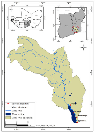
Figure 1.
Location of the lower Mono River catchment.
The estimated catchment population of 3.5 million is distributed between the two countries, representing 32% of the total population of Togo and 16% of the total population of Benin. The majority of this population is of Adja-Ewé origin, composed mainly of Adja, Kotafon, Ouatchi, Sahouè, Ewé, Mina, and Pédah. The Mono River allows a wide diversity of economic activities: market gardening, fishing, artisanal palm oil production (which requires large quantities of water), as well as agriculture, raising livestock, processing agricultural products, trade, and firewood harvesting [63].
2.2. Data Collection and Analysis
This study was conducted using focus group discussions and ARDI workshops with local communities and experts in Benin and Togo.
Focus groups were first conducted to get the general understanding of floods in the study area. A total of four focus groups of 50 willing participants were organized in July 2020 (two per village: one with only men and one with only women). Based on our knowledge of the study area, female participants would not speak openly in the presence of men. Therefore, they were separated to avoid bias and to give the opportunity for female participants to openly share their knowledge (Figure 2). Topics discussed during focus groups were grouped as follows: perception of (i) the frequency and severity of flooding; and (ii) causes and impact of flooding on local communities. Focus group participants were farmers, pastoralists, traders, hunters, and local authorities, with ages ranging from 23 to 81 years old. We worked with local Red Cross focal points and village chiefs in order to select focus groups participants.
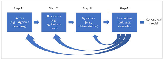
Figure 2.
Flowchart of ARDI approach.
In addition to the focus groups, two workshops were conducted in July 2020 in the villages of Batonou and Agbanakin (Togo) to better understand the perception of flood events from local knowledge and to codevelop a mental model of the local communities (Figure 3). A total of 50 willing participants attended each workshop, of which half were from Batonou and the other half were from Agbanakin. The participants were selected through the assistance of local authorities to represent all sectors of activity in the villages (farmers, fishermen, herders, traders, etc.) The workshop participants represented the local communities and were the same people who had participated in the focus groups.
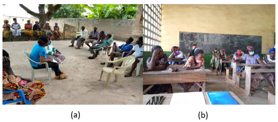
Figure 3.
(a) Focus group discussion in Agbanakin and (b) ARDI workshop in Batonou with local communities ( own photo).
For the group of experts, a virtual workshop was organized via ZOOM in August 2020. Experts from both Benin and Togo participated. Twenty-eight participants (experts) from different institutions (e.g., ministries, researcher institutions, NGOs, and local authorities) involved in flood management in Benin and Togo formed the expert group (Table A1 in Appendix A). All represented institutions have local expertise and strong influence on developing and implementing flood management strategies. Mentimeter (online software, www.mentimeter.com) (accessed on 26 August 2020) was used to create the mental model of the experts.
The following questions were based on the ARDI method and were asked to both groups.
- Who are the key actors playing a decisive role in flood management (direct and indirect actors)?
- What are the main resources of the study area that are affected by the floods (resources)?
- What are the main drivers and processes that would influence changes in the study area (dynamics)?
- What are the interactions—actions linking actors, resources, and drivers and processes (interactions)?
In each of the first three questions, the respondents were asked to rank their answers according to level of importance (ranking “1” as the highest). Whereas for the last question (interaction), workshop participants collaborated as we created the conceptual model by linking key actors, affected resources, and actions. The participants were asked to come up with the action (verb) that describes the type of relationship that exists between the actor and a particular resource. This part of the workshops was particularly rich in discussion and insight from the participants and helped us to understand the dynamic nature of the Mono River catchment. Moreover, the participants came up with a number of actions that were both effective and well-justified. The sessions’ decisions and debates resulted in a graphical representation of how communities and experts perceive the flood system.
3. Results
This section presents the key findings of this study. It is structured as follows: a brief description of the causes and impacts of flooding based on the perspectives of various experts and communities in the study area (Section 3.1); the key actors, affected resources, and dynamics that drive change; conceptual models of the local communities and experts as a result of synthesizing the key steps (Section 3.2, Section 3.3, Section 3.4 and Section 3.5); and comparison of conceptual models.
3.1. Causes and Impact of Floods
The causes of floods and the most affected sectors in the study area are presented in Table 1. Flood events in the study area occurred naturally every three to five years since 1988. However, after the establishment of the Nangbéto hydroelectric dam in September 1987, the local communities described floods as an annual event in the Mono catchment. For them, the primary cause of flooding is the release of water from the Nangbéto dam. Climate change is also reported as one of the main causes of extreme flood events.

Table 1.
Ranking of causes and most-affected sectors of floods according to local communities (rank 1 is the greatest weighted cause or affected, 7 is the least weighted).
The respondents also ranked the most flood-affected sectors in the study area. This ranking from 1 to 7 was done from the most-affected sector to the least-affected sector. Accordingly, agriculture and settlement areas appear to be most affected by floods, followed by breeding and quality of surface water. In fact, all participants reported and agreed that floods have a major impact on their crops and livestock. During flood events, access to farms is extremely difficult, and even if some of the population can gain access to their fields, the majority of their crops have already been lost. Indeed, crops and livestock are almost completely destroyed during flood events, resulting in reduced income and investment losses. This situation is highly alarming because the majority of the population depends on agricultural for their livelihood. In terms of settlement areas, houses in the surveyed localities are mostly built with precarious materials (e.g., wood and clay houses with straw roofs). Additionally, several houses are built on the floodplains of the Mono River, which increases the vulnerability of people to floods. According to the local communities, this results in cracking, tilting, and often the collapse of houses during floods, causing loss of human life and of property.
3.2. Actors
Table 2 presents the ranking of direct actors involved in flood management based on expert (public institutions) and local community perspectives. Both groups identified eight direct actors, but there are some dissimilarities in ranking. Direct actors are those who have a direct link with the natural resource, such as farmers with agricultural land, and indirect actors are those who influence the direct actors in the management of floods but who do not have a link with the resource, such as the Red Cross, which helps the population manage floods. The local communities identified commercial farmers as the most direct actors of flood management in the Mono River. From the community perspectives, farmers are the first to be involved in flood management, as they are the ones who experience the most damage. In contrast, local experts in Togo ranked the Nangbéto hydroelectric dam as the most direct actor of flood management; whereas the local experts in Benin ranked the subsistence farmers as the most direct actors. For experts in Togo, the dam is a direct actor not because it causes flooding, but because it controls the water. Furthermore, fishermen are ranked second by Beninese experts, while they are not listed at all by Togolese experts, and they are ranked last by the local communities because, according to the local communities, fishermen are the actors least affected by the floods and are not much involved in flood management.
Table 2.
Ranking of direct actors according to experts and local communities.
In term of indirect actors, eight were listed by experts, two of them (Mono Catchment Authority and local population) were not considered by the communities as indirect actors (Table 3). In fact, the respondents representing the local communities consider themselves as direct actors, while experts in Togo identify themselves as indirect actors. This difference in perspective highlight the urgent need to consider and recognize the direct participation of local communities in the development of flood management strategies. In addition, experts in Togo and Benin as well as the local communities ranked village leaders as the most important actors for helping farmers, herders, traders, and other local residents become more resilient to flooding. They are followed by the National Agency for Civil Protection (ANPC) for the experts in Benin and Togo, but for the local population, ANPC occupied almost the last position. Another important result is that experts recognized programs, projects, and research institutes as indirect actors intervening in the lower Mono watershed, whereas local people did not recognize them.
Table 3.
Ranking of indirect actors according to experts and local communities.
3.3. Resources
Both local experts and communities agree that cultivated land is the resource most affected by floods (Table 4). This suggests that agriculture is perceived to be the sector most affected by flood, putting people’s livelihoods and food security in jeopardy. However, there are more differences than similarities in the affected resources. For example, local communities recognized forest products, such as wood and fruits, as resources, whereas experts perceive the forest itself as a resource (but not specifically its products). This is also the case regarding fishery products, which were not reported by experts as a resource. Indeed, fishery products and roads are only mentioned by the communities, while groundwater was unique to experts. While the experts rated forests and plant formations as the second most affected resource, local communities ranked agricultural products as the second most flood-affected resource. This highlights the importance of agriculture in the area, as well communities’ dependence on it to meet their food needs. As for forests and plants, households highly depend on them for energy (wood) and food. Thus, when forests and farms are inundated, it becomes difficult for households to get access to dry wood and even to transport harvested wood home.
Table 4.
Ranking of resources according to experts and local communities.
The resources reported in Table 4 suggest that local communities are more specific in describing the affected resources that are linked to their livelihoods, whereas experts describe the resources from a more general overview.
3.4. Dynamics
Table 5 summarizes the different dynamics/processes that were perceived to drive changes in the study area. Ecological, sociological, economic, and technological dynamics were identified by both experts and communities. However, fewer processes were reported from the communities, probably due to difficulty for participants to identify dynamics due to limited knowledge or misunderstanding of terms.
Table 5.
Identification of dynamics/processes that drive changes in the Mono River catchment.
Ecological: Regarding ecological dynamics, river overflow, deforestation, inundation and erosion were the main problems identified in the Mono catchment by both experts and local communities. Participants stated that these different issues have caused losses of land, decreased productivity, and consequently reduced yield. Experts stated river overflow resulting from extreme rainfall events as the main driver of flooding in the area, whereas local communities reported that flooding (inundation) was caused mostly by river overflow triggered by water release from the Nangbéto dam.
Sociological: Participants representing both local communities and experts considered rapid population growth as the biggest current social problem in the Mono catchment, as it increases human pressure on land resources and other natural resources in general. This has resulted in rising unemployment rates, poverty, and rural people migrating to cities. Moreover, according to the experts, water and air pollution are another threat that lowers human health and well-being in the area.
Economic: The expert group listed five economic processes, whereas local communities identified fewer. Local communities reported a decrease in incomes due to losses of land and reduction in crop production. They also stated that the loss of land and animals increased their financial burden as they must buy food items (e.g., rice, maize, fish, milk, sugar) because they can no longer meet their yearly food needs through farming and fishing. They claimed that they need assistance (financial, technical, and logistic) in order to boost farm productivity or undertake alternative activities to be able to reverse the effects of flooding on their incomes. Furthermore, experts reported that factories are becoming prevalent in the area, resulting in overexploitation of natural resources and, therefore, posing a threat to the growth of small commercial activities carried out by households.
Technological: The installation of dams and dikes was the only technological aspect that was identified by the experts. In contrast, the local community groups were not able to identify technological dynamics during the workshop, probably due to limited knowledge of the subject.
3.5. Interactions
The identified actors, resources, and dynamics/processes related to flood management in the lower Mono River catchment were linked based on the perceptions of local communities and experts. As a result, two conceptual models of flooding according to households and experts were developed (Figure 4). As seen in the previous sections, these two mental models look slightly different in terms of identified actors, resources, and dynamics (drivers of changes). In addition, the relationships and actions between actors and a given resource also registered some differences according to the perspectives of local communities and experts. For example, the local community groups reported that commercial farmers produce their own agricultural products for sale, but they also buy them from subsistence farmers for commercial purposes. However, this is different from the actions that the experts identified. For them, commercial farmers are self-sufficient and are not supplied by subsistence farmers. Another important action mentioned by the experts is that commercial farmers also damage the soil because of the intensification of agriculture and the use of chemical substances. In addition, the perception that the Nangbéto dam releases water and causes flooding is linked to the surface water that the local people were most concerned about. The experts addressed this issue as well, but they also emphasized that the Nangbéto dam also exploits surface water, particularly that of the Mono River, for producing electricity. Despite the fact that subsistence farmers and herders were not aware that their activities pollute the river, experts kept raising this issue during the workshop. Moreover, local communities mentioned traders buying various types of natural resources available for resale and directly exploiting forest resources for the purpose of selling. Experts did not mention traders, but they did talk about other actors, such as mining companies, artisanal exploiters, and water companies, whose purpose is to commercialize mining, forest (including timber), and surface and subsurface water resources (including salt extraction, and others), and therefore cause environmental degradation in the area.
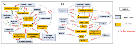
Figure 4.
Diagram of interactions according to (a) Local communities; (b) Experts (Note: AP = Agricultural growth, D = Deforestation, E = Erosion, F = Flood, IDD = Installation of dam and dikes, LCL = Loss of cultivated land, LL = Loss of livelihood, PG = Population growth, RR = Resource reduction.)
The local communities, although living near the resources, are not well aware of the effects of their actions on the risk of flooding, nor the effects of the actions of external actors, such as industries that exploit the various resources in the area. For them, mainly the Nangbéto dam contributes to the increase in risk. The experts have pushed their reasoning beyond this and have been able to bring out unsuspected aspects of interactions between actors and resources with potential approaches for better flood management.
4. Discussion
Our findings highlighted some dissimilarities between expert and local community perceptions on flooding using the ARDI approach. This could be because local communities represented in this study often live closer to the river and therefore in a high flood-risk zone compared to the local experts. As a result, their perspectives and experiences on flooding differ. Similarly, Baggio and Rouquette [15] found that the social representation of flooding is mostly based on the interaction of proximity to the risk and the severity of the disaster, indicating that perceptions differ between those who are directly affected by flooding and those who simply discuss it. As a result, the main differences observed in this study between experts and local communities are as follows.
4.1. Perceived Actors
Local communities were more likely to identify household-based flood management actors instead of institutional actors. Experts, on the other hand, identified flood management companies and institutional organizations. They recognized the role of communities in solving the flood effects related to their traditional knowledge and experience. This reflects that communities/households are no longer seen as only victims of floods, but also as managers, which could be a great benefit to minimize the impact of future floods and optimize beneficial decision making [72]. It has been shown that local communities should be involved and be given priority in disaster reduction efforts since they are the most affected groups and at the same time the first responders to the flood occurrence [73,74]. They must be given more opportunities to actively participate, and the government must encourage and support community-based flood-management efforts. This is particularly important in Africa, where local communities are rarely involved in decision making and have limited access to financial flood management initiatives [75]. In fact, during our workshop, household participants revealed that they manage flood effects primarily on their own and do not always receive government assistance. This could explain why, contrary to experts who regard local and national government as one of the primary actors in flood management, local communities ranked government actors lower in our results.
4.2. Perceived Resources
In addition, our research reveals that experts have a broader perspective on the issue of flooding. Indeed, experts perceived ecosystems (e.g., forest, river) and their goods and services as a single entity and resource, whereas local communities only considered the services and goods derived from the ecosystems (non-timber and timber forest products, fishery products) as a resource. This difference could be related to the specific food needs and the importance of forest and fishery products in daily life in rural areas, especially as a source of income and nutrition [76], as well as to the lack of expertise and awareness of the importance of other ecosystem services and functions. However, when ranking the most affected resources, both groups agreed that cropland is the primary resource affected by flooding. This confirms that flooding severely affects the agricultural sector, including washing away crop and livestock [63,77].
4.3. Perceived Drivers and Interactions
The study also looked at how experts and local communities perceive actors’ interventions on resources, particularly on surface water (rivers). It was noticed that local communities identified the influence of the Nangbéto dam on surface water as the main driver of the high recurrence of floods in the Mono River catchment. According to them, the dam releases a significant volume of water into the Mono River, which consequently increases the river flow. This finding corroborates the results of Ntajal et al. [5] in Togo and Koubodana et al. [64] in Togo and Benin, who reported that the source of flooding in the Mono River catchment was not only due to extremely high rainfall but also improper regulation of the Nangbéto dam. According to experts, in addition to modification of the river region due to the implementation of the Nangbéto dam and its water release, natural and anthropogenic pressures, land use, and climate change also increase the risk of flooding in the Mono River catchment, as confirmed by previous studies in the region [12,13,78].
4.4. Lessons Learned and Recommendations
Experts’ perceptions on floods must be taken with some caution, because most of them are not based on personal experience or circumstantial evidence, compared to those of local communities. The experts, although they have professional judgment on flood management, are not directly living in flood-prone areas; as a result, many things escape their attention. For example, the fact that the experts in Togo give ANPC a prominent place in the ranking of actors whereas the local communities hardly recognize them. As a result, when it comes to flood management, it would be important to promote proper communication and participatory activities. Better communication of risk among the actors involved would be of great help to the local community in terms of knowing where to seek assistance during flood events. It could even help to avoid the development of policies that do not target the needs of the population, as well as the implementation of inappropriate adaptation measures [79]. All the actors who intervene in the area, whether governmental or non-governmental, should regularly meet and discuss with the local communities so that the population can benefit from their expertise to better manage flood events; they, in turn, can become aware of the reality of the community’s experience. This can facilitate the way of integrating local communities into the decision-making process, especially at the governmental level in the various expert judgments [75]. Participatory flood management is therefore a response to be considered to understand and learn from local communities, including their flood measures and to consider indigenous or endogenous knowledge in flood management. As previously reported by Bustillos et al. [80] and Villamor et al. [81], the use of participatory management promotes participation and facilitates communication and social learning processes among stakeholders, but, most importantly, it can create reliable, quantitative, and easy-to-use material useful for comparison and collaborative decision making.
Capturing the different perspectives of experts and local communities has demonstrated the need for integrating expertise in both the assessment and management of floods. For example, the local communities’ attention is focused on the effects of the Nangbéto dam on flooding to the point where they overlook their own actions that could increase the risk of floods, particularly the disposal of waste into the river. On the other hand, experts, in addition to the dam, focus on anthropogenic activities and climate change as primary drivers of floods in the area. By recognizing these two different knowledge bases, co-learning and co-creation of a flood management information system will become more representative and comprehensive [82]. For this reason, Scholten et al. [83] proposed to combine expert knowledge with local data in order to take into account the uncertainties created on both sides. That is, neither expert-only nor local community-only models provide an accurate representation of flood events in the Mono River catchment, but when they are coupled, the uncertainty becomes less.
Regarding the social, ecological, economic and technological dynamics, the experts show a certain mastery of the subject, whereas the local communities do not manage to sufficiently communicate these topics during workshops. The low level of education of the population is becoming visible at this level. Indeed, the local communities experience the situation, but they do not know how to properly describe it. According to Birkholz et al. [84], it is very important to pay attention to the fact that too much emphasis has always been placed on the cognitive perceptions of those at risk, to the detriment of a richer understanding of a wider range of flood risk perceptions, such as those of policy makers or taxpayers who live outside flood-affected areas.
In terms of resource–actor interactions, a complementary or combination of views from different stakeholders would identify the most vulnerable sectors and select the most appropriate adaptation strategies for better mitigation and adaptation to flood risks. Here, by combining the opinion of experts and local communities, the agricultural sector is the sector that requires urgent action.
5. Conclusions
This study highlights the perspectives of experts and local communities on floods in the Mono River catchment using focus group discussions and the ARDI approach. Overall, the perceptions of the experts and the local communities show good knowledge and understanding of floods and their interactions in the region. Nevertheless, some differences were observed in the perceptions of the system. For example, the local communities and the experts do not fully agree on the causes of flooding in the area. Indeed, based on the identification of dynamics and interactions, the local communities point out the Nangbéto dam as the main driving force of flooding in their homes and farms, while experts consider that, in addition to the Nangbéto dam, anthropogenic pressures and climate change are also important factors to consider when listing the causes of flooding in the catchment. In addition, local communities consider themselves to be the main direct actors who should be involved in flood management, as they are the ones directly affected. This indicates that individual citizens are ready and aware of their responsibility in adopting measures and preparing against floods, which poses an important starting point for the government and residents in the context of flood management in Mono. The experts also retain a similar view of the local communities as a direct actor, especially the farmers. This highlights the importance of taking into account the knowledge of the local population in the assessment and management of floods. Furthermore, their different perceptions of the interactions between actors, resources, and drivers of change in the context of flooding could be due to the fact that experts and local people do not experience the same effects of flooding and do not have the same socio–economic priorities and dependencies—local people are directly affected by flooding as they are living in flood-prone areas, whereas experts do not always live there. The perception of the local communities is probably affected by their socio–economic needs. Despite partly differing from the views of the local communities, experts agreed that floods have a greater impact on the agricultural and livestock sectors. In order to take into account expert as well as community perspectives and thus avoid the implementation of policies and strategies that are built from only one point of view, it is vital to implement proper communication and participatory activities involving both local communities and experts. It is also highly important to engage communities in risk management planning by connecting their needs and concerns to the mitigation plans.
Author Contributions
Conceptualization, E.N.P. and G.B.V.; methodology E.N.P., S.T. and G.B.V.; formal analysis, E.N.P. and S.T.; investigation, E.N.P., S.T. and K.A.; data curation, E.N.P. and S.T.; writing—original draft preparation, E.N.P. and S.T.; writing—review and editing, E.N.P., S.T., G.B.V., S.V., K.K., K.A. and J.G.A.; supervision, K.K. and G.B.V.; funding acquisition, S.T. and S.V. All authors have read and agreed to the published version of the manuscript.
Funding
This research was funded by the German Federal Ministry of Education and Research (BMBF), grant number: 01LZ1710C.
Institutional Review Board Statement
Not applicable.
Informed Consent Statement
Not applicable.
Data Availability Statement
Not applicable.
Acknowledgments
This research was conducted within the CLIMAFRI project (Implementing Climate-sensitive Adaptation strategies to reduce Flood Risk in the transboundary Lower Mono River catchment in Togo and Benin). We are grateful to the team of the Forest Research Laboratory (LRF) of the University of Lomé and all our field assistants for their collaboration. We would also like to acknowledge the support of all the village and neighborhood chiefs, village development committees, members of the local Red Cross, farmers, and traders of the Lower Mono catchment. We are grateful to all stakeholders and to our partners of WASCAL programs in Togo and Benin for their valuable input and support during our workshops.
Conflicts of Interest
The authors declare no conflict of interest.
Appendix A
Table A1.
List of institutions who participated in the workshops.
Table A1.
List of institutions who participated in the workshops.
| Participants Togo | Participants Benin |
|---|---|
| Director of water ressource | Generale director for water |
| National Agnecy for civil protection (ANPC) | Mono catchment authority representative |
| Jeune volontaire pour l’environnement (JVE) | ANPC |
| Institut togolais de la recherche agronomique (ITRA) | JVE |
| Caritas Togo | Partenariat national de l’eau du Benin (PNE-Benin) |
| Ministry of agriculture | Institut national des recherches agronomiques du Benin (INRAB) |
| Eau vive Togo | ADELAC (Réhabilitation du Lac Athiémé) |
| Red cross | Ministry of agriculture |
| Mécanisme incitatif de financement agricole (MIFA) | Caritas Benin |
| Nangbeto dam authority | GIZ Benin |
| Wascal Togo | Ministry of environment |
| Red cross | |
| PAUWES | |
| UNCCD National climate fund | |
| Commune d’Athiémé | |
| Wascal Benin |
References
- Lal, P.N.; Mitchell, T.; Aldunce, P.; Auld, H.; Mechler, R.; Miyan, A.; Romano, L.E.; Zakaria, S. National systems for managing the risks from climate extremes and disasters. In Managing the Risks of Extreme Events and Disasters to Advance Climate Change Adaptation; Special Report of the Intergovernmental Panel on Climate Change; Cambridge University Press: Cambridge, UK, 2012; pp. 339–392. [Google Scholar]
- Sadiq, A.-A. Adoption of Hazard Adjustments by Large and Small Organizations: Who is Doing the Talking and Who is Doing the Walking? Risk Hazards Crisis Public Policy 2011, 2, 1–17. [Google Scholar] [CrossRef]
- Mahe, G.; Lienou, G.; Descroix, L.; Bamba, F.; Paturel, J.E.; Laraque, A.; Meddi, M.; Habaieb, H.; Adeaga, O.; Dieulin, C.; et al. The rivers of Africa: Witness of climate change and human impact on the environment. Hydrol. Process. 2013, 27, 2105–2114. [Google Scholar] [CrossRef]
- Wagner, S.; Souvignet, M.; Walz, Y.; Balogun, K.; Komi, K.; Kreft, S.; Rhyner, J. When does risk become residual? A systematic review of research on flood risk management in West Africa. Reg. Environ. Chang. 2021, 21, 84. [Google Scholar] [CrossRef]
- Ntajal, J.; Lamptey, B.L.; Mahamadou, I.B.; Nyarko, B.K. Flood disaster risk mapping in the Lower Mono River Catchment in Togo, West Africa. Int. J. Disaster Risk Reduct. 2017, 23, 93–103. [Google Scholar] [CrossRef]
- WEDO; UNFPA. Climate change connections: Gender, Population and Climate Change. Biocycle 2009, 52, 59–60. [Google Scholar]
- O’Connor, J.E.; Grant, G.E.; Costa, J.E. The Geology and Geography of Floods. Water Sci. Appl. 2013, 5, 359–385. [Google Scholar] [CrossRef]
- Descroix, L.; Guichard, F.; Grippa, M.; Lambert, L.A.; Panthou, G.; Mahé, G.; Gal, L.; Dardel, C.; Quantin, G.; Kergoat, L.; et al. Evolution of Surface Hydrology in the Sahelo-Sudanian Strip: An Updated Review. Water 2018, 10, 748. [Google Scholar] [CrossRef]
- Thiam, S.; Salas, E.A.L.; Hounguè, N.R.; Almoradie, A.D.S.; Verleysdonk, S.; Adounkpe, J.G.; Komi, K. Modelling Land Use and Land Cover in the Transboundary Mono River Catchment of Togo and Benin Using Markov Chain and Stakeholder’ s Perspectives. Sustainability 2022, 14, 4160. [Google Scholar] [CrossRef]
- Shang, X.; Jiang, X.; Jia, R.; Wei, C. Land Use and Climate Change Effects on Surface Runoff Variations in the Upper Heihe River Catchment. Water 2019, 11, 344. [Google Scholar] [CrossRef]
- Rameshwaran, P.; Bell, V.A.; Davies, H.N.; Kay, A.L. How might climate change affect river flows across West Africa? Clim. Chang. 2021, 169, 21. [Google Scholar] [CrossRef]
- Hounguè, N.R.; Ogbu, K.N.; Almoradie, A.D.S.; Evers, M. Evaluation of the performance of remotely sensed rainfall datasets for flood simulation in the transboundary Mono River catchment, Togo and Benin. J. Hydrol. Reg. Stud. 2021, 36, 100875. [Google Scholar] [CrossRef]
- Koubodana, D.; Adounkpe, J.; Tall, M.; Amoussou, E.; Atchonouglo, K.; Mumtaz, M. Trend Analysis of Hydro-climatic Historical Data and Future Scenarios of Climate Extreme Indices over Mono River Catchment in West Africa. Am. J. Rural Dev. 2020, 8, 37–52. [Google Scholar]
- Ertan, S.; Çelik, R.N. The Assessment of Urbanization Effect and Sustainable Drainage Solutions on Flood Hazard by GIS. Sustainability 2021, 13, 2293. [Google Scholar] [CrossRef]
- Baggio, S.; Rouquette, M.-L. The Social Representation of the Flood: The Overlapping Influence of Proximity to Risk and the Importance of the Stake. Bull. Psychol. 2006, 481, 103–117. [Google Scholar] [CrossRef]
- Kellens, W.; Terpstra, T.; De Maeyer, P. Perception and Communication of Flood Risks: A Systematic Review of Empirical Research. Risk Anal. 2013, 33, 24–49. [Google Scholar] [CrossRef]
- Lechowska, E. What determines flood risk perception? A review of factors of flood risk perception and relations between its basic elements. Nat. Hazards 2018, 94, 1341–1366. [Google Scholar] [CrossRef]
- Okaka, F.O.; Odhiambo, B.D. Households’ perception of flood risk and health impact of exposure to flooding in flood-prone informal settlements in the coastal city of Mombasa. Int. J. Clim. Chang. Strat. Manag. 2019, 11, 592–606. [Google Scholar] [CrossRef]
- Becker, G.; Aerts, J.; Huitema, D. Influence of flood risk perception and other factors on risk-reducing behaviour: A survey of municipalities along the Rhine. J. Flood Risk Manag. 2014, 7, 16–30. [Google Scholar] [CrossRef]
- Messner, F.; Meyer, V. Flood damage, vulnerability and risk perception—Challenges for flood damage research. In Flood Risk Management: Hazards, Vulnerability and Mitigation Measures; Springer: Dordrecht, The Netherlands, 2006; pp. 149–167. [Google Scholar] [CrossRef]
- Burton, I.; Kates, R.W.; White, G.F. The Environment as Hazard; Guilford Press: New York, NY, USA, 1993; 290p, Available online: https://books.google.to/books?id=8aK1YcbL5_8C&printsec=frontcover#v=onepage&q&f=false (accessed on 13 August 2021).
- Bubeck, P.; Botzen, W.; Kreibich, H.; Aerts, J.C.J.H. Long-term development and effectiveness of private flood mitigation measures: An analysis for the German part of the river Rhine. Nat. Hazards Earth Syst. Sci. 2012, 12, 3507–3518. [Google Scholar] [CrossRef]
- Beckers, A.; Dewals, B.; Erpicum, S.; Dujardin, S.; Detrembleur, S.; Teller, J.; Pirotton, M.; Archambeau, P. Contribution of land use changes to future flood damage along the river Meuse in the Walloon region. Nat. Hazards Earth Syst. Sci. 2013, 13, 2301–2318. [Google Scholar] [CrossRef]
- Grothmann, T.; Reusswig, F. People at Risk of Flooding: Why Some Residents Take Precautionary Action while Others Do Not. Nat. Hazards 2006, 38, 101–120. [Google Scholar] [CrossRef]
- Raaijmakers, R.; Krywkow, J.; Van Der Veen, A. Flood risk perceptions and spatial multi-criteria analysis: An exploratory research for hazard mitigation. Nat. Hazards 2008, 46, 307–322. [Google Scholar] [CrossRef]
- O’Neill, E.; Brereton, F.; Shahumyan, H.; Clinch, J.P. The Impact of Perceived Flood Exposure on Flood-Risk Perception: The Role of Distance. Risk Anal. 2016, 36, 2158–2186. [Google Scholar] [CrossRef]
- Burns, W.J.; Slovic, P. Risk Perception and Behaviors: Anticipating and Responding to Crises. Risk Anal. 2012, 32, 579–582. [Google Scholar] [CrossRef]
- Durand, S. From the risk culture to the local cultures of risk. An ethnographic investigation of living with a constant flood risk in the South East of France. In Proceedings of the 3rd European Conference on Flood Risk Management (FLOODrisk 2016), Lyon, France, 17–21 October 2016. [Google Scholar]
- Reuter, C.; Kaufhold, M.-A.; Schmid, S.; Spielhofer, T.; Hahne, A.S. The impact of risk cultures: Citizens’ perception of social media use in emergencies across Europe. Technol. Forecast. Soc. Chang. 2019, 148, 119724. [Google Scholar] [CrossRef]
- Bourrelier, P.-H.B.; Deneufbourg, G.; De Vanssay, B. IDNDR Objectives: French Technical Sociological Contributions. Nat. Hazards Rev. 2000, 1, 18–26. [Google Scholar] [CrossRef]
- Scheer, D.; Gold, S.; Benighaus, C.; Benighaus, L.; Ortleb, J.; Renn, O. Communication of Risk and Hazard from the Angle of Different Stakeholders; BfR Wissenschaft: Berlin, Germany, 2008. [Google Scholar]
- Marynissen, H.; Ladkin, D.; Denyer, D.; Snoeijers, E.; Van Achte, T. The Role of Individual Risk Perception in an Organization Managing High Risks. In Proceedings of the Third International Conference on Engaged Management Scholarship, Atlanta, GA, USA, 19–22 September 2013. [Google Scholar]
- Siegrist, M.; Gutscher, H. Natural hazards and motivation for mitigation behavior: People cannot predict the affect evoked by a severe flood. Risk Anal. 2008, 28, 771–778. [Google Scholar] [CrossRef]
- Bradford, R.A.; O’Sullivan, J.J.; Van Der Craats, I.M.; Krywkow, J.; Rotko, P.; Aaltonen, J.; Bonaiuto, M.; De Dominicis, S.; Waylen, K.; Schelfaut, K. Risk perception–issues for flood management in Europe. Nat. Hazards Earth Syst. Sci. 2012, 12, 2299–2309. [Google Scholar] [CrossRef]
- Etienne, M.; Du Toit, D.R.; Pollard, S. ARDI: A Co-construction Method for Participatory Modeling in Natural Resources Management. Ecol. Soc. 2011, 16, 44. [Google Scholar] [CrossRef]
- Rouse, W.B.; Morris, N.M. On Looking into the Black Box. Prospects and Limits in the Search for Mental Models. Psychol. Bull. 1986, 100, 349–363. [Google Scholar] [CrossRef]
- Villamor, G.B.; Guta, D.D.; Mirzabaev, A. Gender Specific Differences of Smallholder Farm Households Perspective of Food-Energy-Land Nexus Frameworks in Ethiopia. Front. Sustain. Food Syst. 2020, 4, 491725. [Google Scholar] [CrossRef]
- Guijt, I. Seeking Surprise: Rethinking Monitoring for Collective Learning in Rural Resource Management. Ph.D. Thesis, Wageningen University, Wageningen, The Netherlands, 2008; pp. 1–22. [Google Scholar]
- Villamor, G.B.; Griffith, D.L.; Kliskey, A.; Alessa, L. Contrasting stakeholder and scientist conceptual models of food-energy-water systems: A case study in Magic Valley, Southern Idaho. Soc.-Environ. Syst. Model. 2019, 2, 16312. [Google Scholar] [CrossRef]
- Dray, S.; Legendre, P.; Peres-Neto, P.R. Spatial modelling: A comprehensive framework for principal coordinate analysis of neighbour matrices (PCNM). Ecol. Model. 2006, 196, 483–493. [Google Scholar] [CrossRef]
- Lynam, T.; Mathevet, R.; Etienne, M.; Stone-Jovicich, S.; Leitch, A.; Jones, N.; Ross, H.; Du Toit, D.; Pollard, S.; Biggs, H.; et al. Waypoints on a Journey of Discovery: Mental Models in Human-Environment Interactions. Ecol. Soc. 2012, 17, 23. [Google Scholar] [CrossRef]
- Jones, N.; Ross, H.; Lynam, T.; Perez, P.; Leitch, A. Mental Models: An Interdisciplinary Synthesis of Theory and Methods. Ecol. Soc. 2011, 16, 46. [Google Scholar] [CrossRef]
- Johnson-Laird, P.N. Mental models and human reasoning. Proc. Natl. Acad. Sci. USA 2010, 107, 18243–18250. [Google Scholar] [CrossRef]
- Lazrus, H.; Morss, R.E.; DeMuth, J.L.; Lazo, J.K.; Bostrom, A. “Know What to Do If You Encounter a Flash Flood”: Mental Models Analysis for Improving Flash Flood Risk Communication and Public Decision Making. Risk Anal. 2016, 36, 411–427. [Google Scholar] [CrossRef]
- Elsawah, S.; Guillaume, J.; Filatova, T.; Rook, J.; Jakeman, A. A methodology for eliciting, representing, and analysing stakeholder knowledge for decision making on complex socio-ecological systems: From cognitive maps to agent-based models. J. Environ. Manag. 2015, 151, 500–516. [Google Scholar] [CrossRef]
- Henly-Shepard, S.; Gray, S.A.; Cox, L.J. The use of participatory modeling to promote social learning and facilitate community disaster planning. Environ. Sci. Policy 2015, 45, 109–122. [Google Scholar] [CrossRef]
- Fernández-Berrocal, P.; Santamaria, C. Mental Models in Social Interaction. J. Exp. Educ. 2006, 74, 227–248. [Google Scholar] [CrossRef]
- Boase, N.; White, M.; Gaze, W.; Redshaw, C. Evaluating the Mental Models Approach to Developing a Risk Communication: A Scoping Review of the Evidence. Risk Anal. 2017, 37, 2132–2149. [Google Scholar] [CrossRef]
- Gibson, H.; Stewart, I.; Pahl, S.; Stokes, A. A “mental models” approach to the communication of subsurface hydrology and hazards. Hydrol. Earth Syst. Sci. 2016, 20, 1737–1749. [Google Scholar] [CrossRef]
- Helgeson, J.; van der Linden, S.; Chabay, I. The Role of Knowledge, Learning and Mental Models in Public Perceptions of Climate Change Related Risks; Wageningen Academic Publishers: Wageningen, The Netherlands, 2012; pp. 381–394. [Google Scholar]
- Reynolds, T.W.; Bostrom, A.; Read, D.; Morgan, M.G. Now What Do People Know About Global Climate Change? Survey Studies of Educated Laypeople. Risk Anal. 2010, 30, 1520–1538. [Google Scholar] [CrossRef]
- Kahneman, D. A perspective on judgment and choice: Mapping bounded rationality. Am. Psychol. 2003, 58, 697–720. [Google Scholar] [CrossRef]
- Bessette, D.; Mayer, L.A.; Cwik, B.; Vezér, M.; Keller, K.; Lempert, R.J.; Tuana, N. Building a Values-Informed Mental Model for New Orleans Climate Risk Management. Risk Anal. 2017, 37, 1993–2004. [Google Scholar] [CrossRef]
- Austin, L.; Fischhoff, B. Injury prevention and risk communication: A mental models approach. Inj. Prev. 2012, 18, 124–129. [Google Scholar] [CrossRef]
- Loroño-Leturiondo, M.; O’Hare, P.; Cook, S.J.; Hoon, S.R.; Illingworth, S. Building bridges between experts and the public: A comparison of two-way communication formats for flooding and air pollution risk. Geosci. Commun. 2019, 2, 39–53. [Google Scholar] [CrossRef]
- Voinov, A.; Gaddis, E.J.B. Lessons for successful participatory watershed modeling: A perspective from modeling practitioners. Ecol. Model. 2008, 216, 197–207. [Google Scholar] [CrossRef]
- Mathevet, R.; Etienne, M.; Lynam, T.; Calvet, C. Water Management in the Camargue Biosphere Reserve: Insights from Comparative Mental Models Analysis. Ecol. Soc. 2011, 16, 43. [Google Scholar] [CrossRef]
- Carre, C.; Haghe, J.P.; De Coninck, A.; Becu, N.; Deroubaix, J.F.; Pivano, C.; Flipo, N.; Le Pichon, C.; Tallec, G. How to integrate scientific models in order to switch from flood control river management to multifunctional river management? Int. J. River Catchment Manag. 2014, 12, 231–249. [Google Scholar] [CrossRef]
- Du Toit, D.R.; Biggs, H.; Pollard, S. The Potential Role of Mental Model Methodologies in Multistakeholder Negotiations: Integrated Water Resources Management in South Africa. Ecol. Soc. 2011, 16, 21. [Google Scholar] [CrossRef]
- Reed, M.S. Stakeholder participation for environmental management: A literature review. Biol. Conserv. 2008, 141, 2417–2431. [Google Scholar] [CrossRef]
- Sawadogo, J.-B. Co-Construction of Innovative Farming System for Crop-Livestock Integration in Dano, South-Western Burkina Faso. Master’s Thesis, Université de Lomé, Lomé, Togo, 2018. [Google Scholar]
- Coulibaly, H.; Bazile, D.; Sidibé, A. Modelling Seed System Networks in Mali to Improve Farmers Seed Supply. Sustain. Agric. Res. 2014, 3, 18. [Google Scholar] [CrossRef]
- Kissi, A.E.; Abbey, G.A.; Agboka, K.; Egbendewe, A. Quantitative Assessment of Vulnerability to Flood Hazards in Downstream Area of Mono Catchment, South-Eastern Togo: Yoto District. J. Geogr. Inf. Syst. 2015, 7, 607–619. [Google Scholar] [CrossRef]
- Koubodana, H.D.; Adounkpe, J.; Atchonouglo, K.; Djaman, K.; Larbi, I.; Lombo, Y.; Kpemoua, K.E. Modelling of streamflow before and after dam construction in the Mono River Catchment in Togo-Benin, West Africa. Int. J. River Catchment Manag. 2021; in press. [Google Scholar] [CrossRef]
- Wetzel, M.; Schudel, L.; Almoradie, A.; Komi, K.; Adounkpè, J.; Walz, Y.; Hagenlocher, M. Assessing Flood Risk Dynamics in Data-Scarce Environments—Experiences from Combining Impact Chains with Bayesian Network Analysis in the Lower Mono River Catchment, Benin. Front. Water 2022, 4, 837688. [Google Scholar] [CrossRef]
- Koubodana, D.H.; Diekkrüger, B.; Näschen, K.; Adounkpe, J.; Atchonouglo, K. Impact of the Accuracy of Land Cover Data sets on the Accuracy of Land Cover Change Scenarios in the Mono River Catchment, Togo, West Africa. Int. J. Adv. Remote Sens. GIS 2019, 8, 3073–3095. [Google Scholar] [CrossRef]
- Amoussou, E. Variabilité Pluviométrique et Dynamique Bassin Versant du Complexe la Gunaire Mono-Ahémé-Couffo (Afrique de l’Ouest). Ph.D. Thesis, Université de Bourgogne, Dijon, France, 2010. [Google Scholar]
- PANGIRE. Plan d’Action National de Gestion Integree des Ressources en Eau; Republique du Togo: Lome, Togo, 2016; 74p. [Google Scholar]
- Lamboni, B.; Emmanuel, L.A.; Manirakiza, C.; Djibib, Z.M. Variability of Future Rainfall over the Mono River Catchment of West-Africa. Am. J. Clim. Chang. 2019, 8, 137–155. [Google Scholar] [CrossRef]
- Rossi, G. L’impact des barrages de la vallée du Mono (Togo-Benin). La gestion de l’incertitude. In Géomorphologie: Relief, Processus, Environnement; University de Bordeaux: Bordeaux, France, 1996; Volume 2, pp. 55–68. [Google Scholar] [CrossRef]
- Houngue, N.R. Assessment of Mid-Century Climate Change Impacts on Mono River’s Downstream Inflows. Master’s Thesis, Université de Lomé, Lomé, Togo, 2018; pp. 1–71. [Google Scholar]
- World Meteorological Organization. Community-Based Flood Management; Integrated Flood Management Tools Series; World Meteorological Organization: Geneva, Switzerland, 2017; pp. 1–86. [Google Scholar]
- Patterson, O.; Weil, F.; Patel, K. The Role of Community in Disaster Response: Conceptual Models. Popul. Res. Policy Rev. 2010, 29, 127–141. [Google Scholar] [CrossRef]
- Victoria, L.P. Community Based Approaches to Disaster Mitigation. Regional Workshop on Best Practices in Disaster Mitigation. Philipp. Sociol. Rev. 2002, 51, 65–80. Available online: https://www.jstor.org/stable/44243073?seq=1 (accessed on 10 September 2021).
- Chirenje, L.I.; Giliba, R.A.; Musamba, E.B. Local communities’ participation in decision-making processes through planning and budgeting in African countries. Chin. J. Popul. Resour. Environ. 2013, 11, 10–16. [Google Scholar] [CrossRef]
- Hlaing, Z.C.; Kamiyama, C.; Saito, O. Interaction between Rural People’s Basic Needs and Forest Products: A Case Study of the Katha District of Myanmar. Int. J. For. Res. 2017, 2017, 2105012. [Google Scholar] [CrossRef]
- Saito, O.; Kranjac-Berisavlijevic, G.; Takeuchi, K.; Gyasi, E.A. Strategies for Building Resilience against Climate and Ecosystem Changes in Sub-Saharan Africa; Springer: Singapore, 2018. [Google Scholar]
- Atsri, H.K.; Konko, Y.; Cuni-Sanchez, A.; Abotsi, K.E.; Kokou, K. Changes in the West African forest-savanna mosaic, insights from central Togo. PLoS ONE 2018, 13, e0203999. [Google Scholar] [CrossRef]
- Manning, M.; Lawrence, J.; King, D.N.; Chapman, R. Dealing with changing risks: A New Zealand perspective on climate change adaptation. Reg. Environ. Chang. 2015, 15, 581–594. [Google Scholar] [CrossRef]
- Ardaya, A.B.; Evers, M.; Ribbe, L. Integrated Participatory Methodologies for Disaster Risk Reduction: Tools to Analyze Complex Systems Through Participatory Processes in Brazil. In Strategies and Tools for a Sustainable Rural Rio de Janeiro; Springer: Cham, Switzerland, 2018; pp. 361–376. [Google Scholar]
- Villamor, G.B.; Sharma-Wallace, L.; van Noordwijk, M.; Barnard, T.; Meason, D.F. A systematic review of participatory integrated assessment at the catchment scale: Lessons learned from practice. Curr. Res. Environ. Sustain. 2022; in press. [Google Scholar]
- Villamor, G.B.; Palomo, I.; Santiago, C.A.L.; Oteros-Rozas, E.; Hill, J. Assessing stakeholders’ perceptions and values towards social-ecological systems using participatory methods. Ecol. Processes 2014, 3, 22. [Google Scholar] [CrossRef]
- Scholten, L. Multi-Criteria Decision Analysis for Water Supply Infrastructure Planning under Uncertainty. Ph.D. Thesis, Technische Universität Dresden, Dresden, Germany, 2015. [Google Scholar]
- Birkholz, S.; Muro, M.; Jeffrey, P.; Smith, H. Rethinking the relationship between flood risk perception and flood management. Sci. Total Environ. 2014, 478, 12–20. [Google Scholar] [CrossRef]
Publisher’s Note: MDPI stays neutral with regard to jurisdictional claims in published maps and institutional affiliations. |
© 2022 by the authors. Licensee MDPI, Basel, Switzerland. This article is an open access article distributed under the terms and conditions of the Creative Commons Attribution (CC BY) license (https://creativecommons.org/licenses/by/4.0/).