ConFormer-Net: Spatiotemporal Modeling for Landslide Detection Using Multi-Temporal SAR Data
Highlights
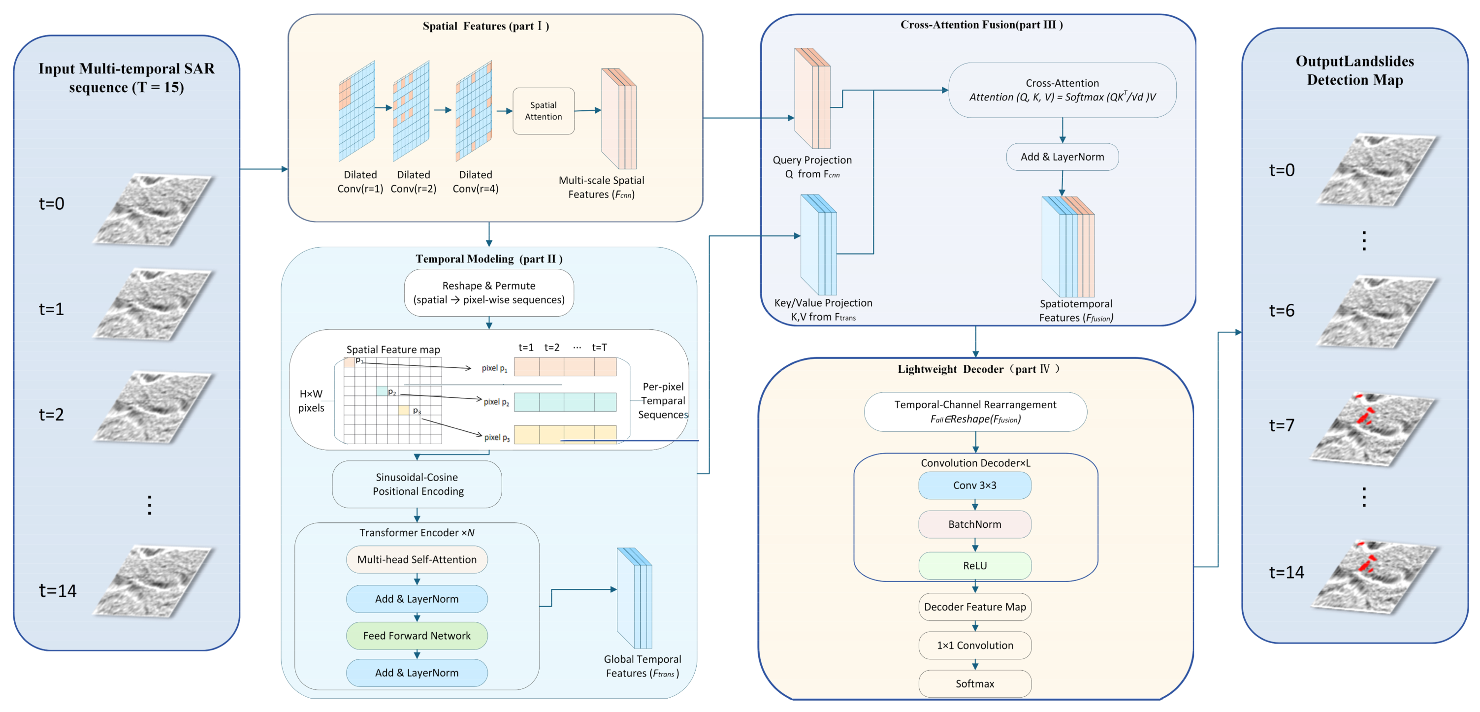
- ConFormer-Net combines multiscale dilated convolutions, sinusoidal positional encoding, Transformer-based temporal modeling, and cross-attention to jointly capture spatial structures and long-range temporal changes in multi-temporal SAR imagery.
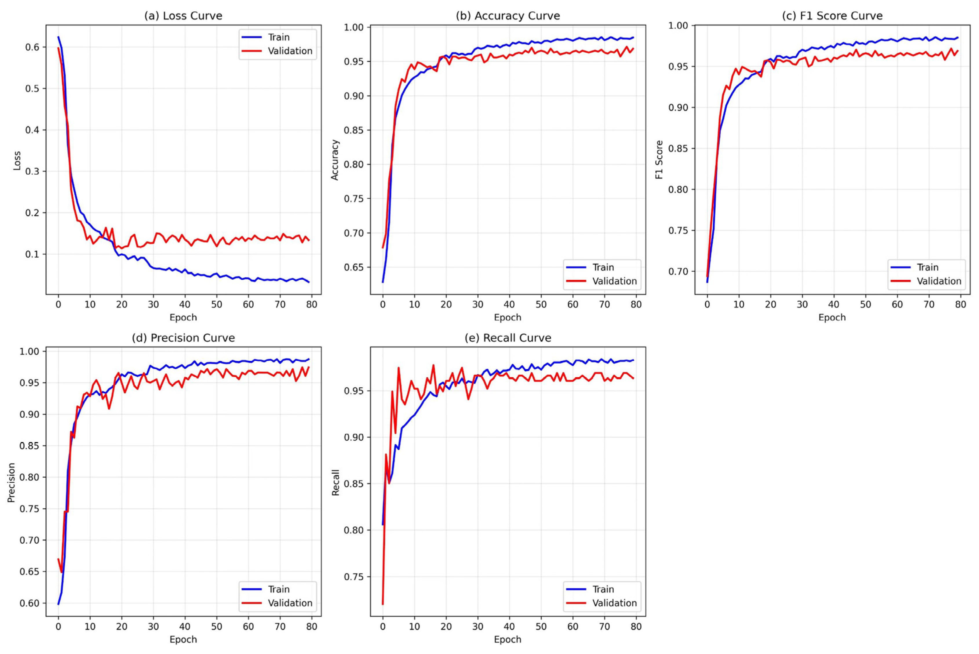
- ConFormer-Net achieved an F1-score of 95.27%, an accuracy of 95.29%, a precision of 96.79%, and a recall of 93.79%, achieving the best overall performance among all comparison models; ablation experiments identified temporal modeling as the primary contributor to performance improvement.
- Joint spatiotemporal modeling improves the discrimination of landslide-induced changes from vegetation disturbance, terrain shadows, bare ground, and SAR speckle noise, thereby reducing false detections in complex mountainous environments.
- ConFormer-Net achieved high detection accuracy and stable performance under different terrain conditions and landslide morphologies, providing an effective approach for landslide detection in complex terrain environments.
Abstract
1. Introduction
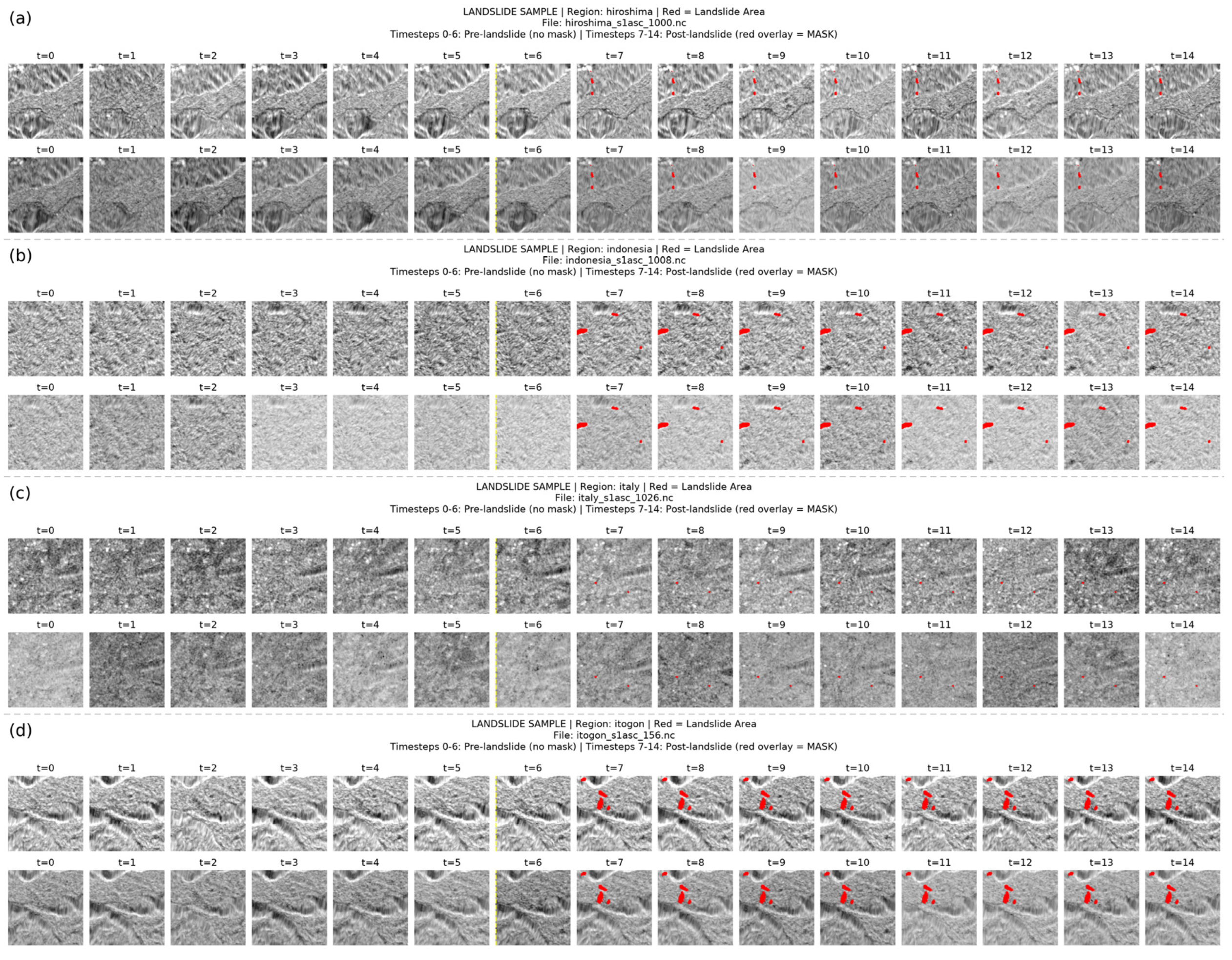
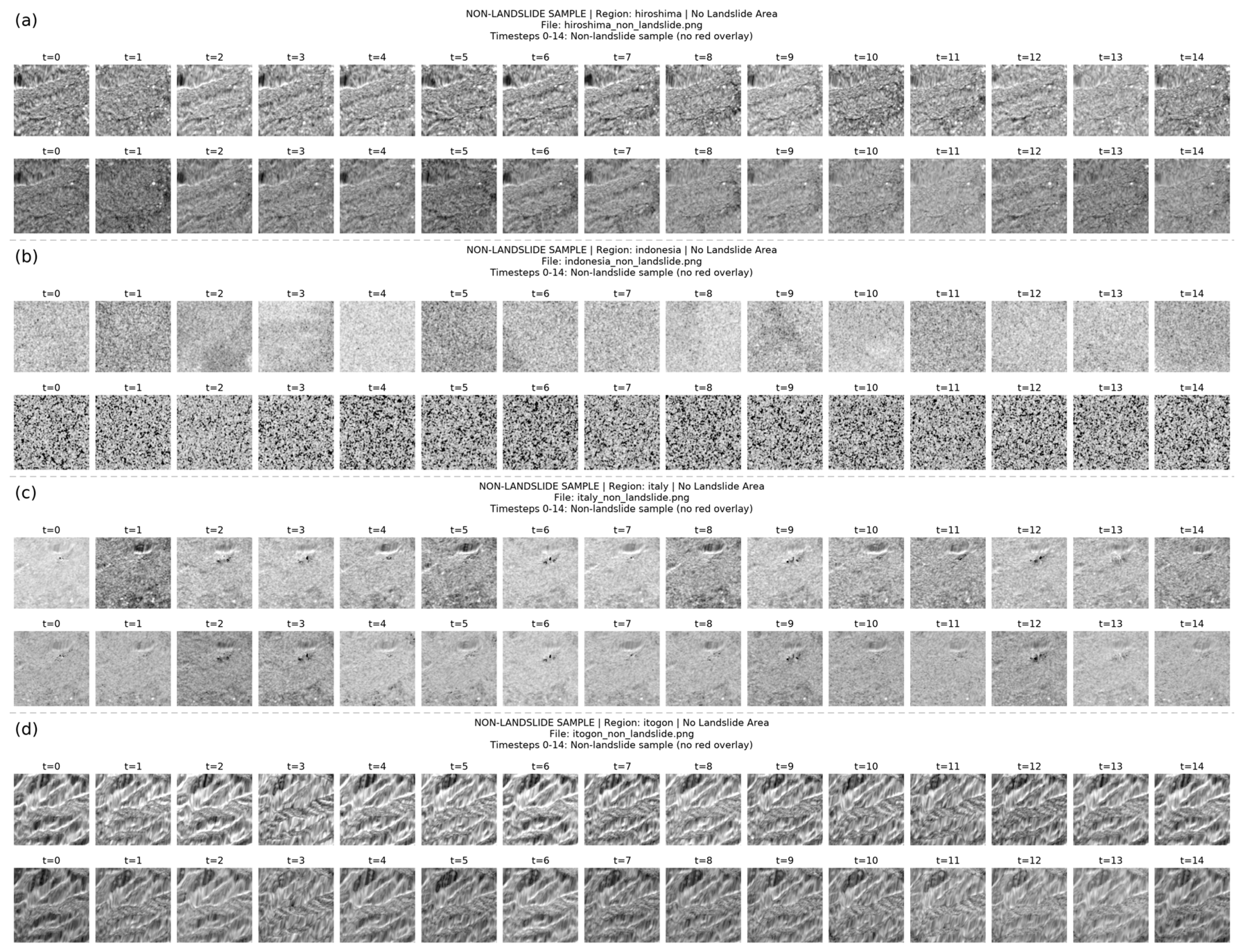
- A spatiotemporal collaborative modeling framework is proposed for landslide detection using multi-temporal SAR data. Unlike conventional CNN-based methods that primarily focus on local spatial features, ConFormer-Net simultaneously captures local landslide morphology and long-term temporal changes, thereby improving the representation of landslide evolution in complex mountainous environments.
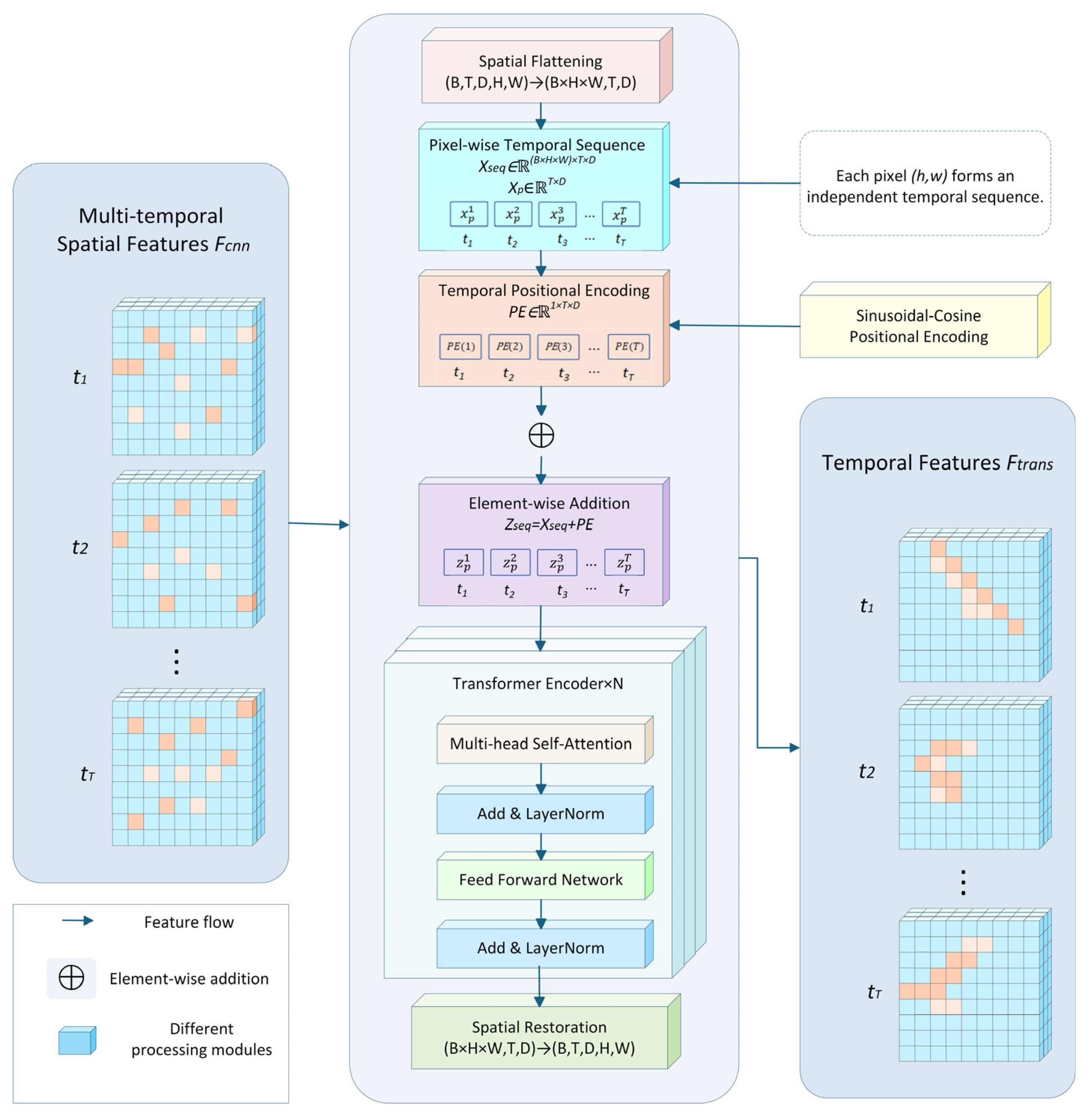
- To address the inability of Transformers to inherently perceive positional information, sinusoidal positional encoding is introduced into the temporal modeling module. This encoding incorporates the temporal positions of individual observations and enables the self-attention mechanism to distinguish their chronological order. Consequently, the model can more effectively differentiate temporal changes before and after landslide occurrence and improve its representation of the temporal evolution of landslides.
- A spatiotemporal feature fusion module based on cross-attention is designed. The local spatial features extracted by the CNNs are used as the Query, while the long-range temporal dependency features modeled by the Transformer are used as the Key and Value. This design enables adaptive interaction modeling between spatial information and long-range temporal dependencies, thereby enhancing the model’s ability to distinguish landslide areas from non-landslide areas under complex terrain conditions and background interference.
2. Materials and Methods
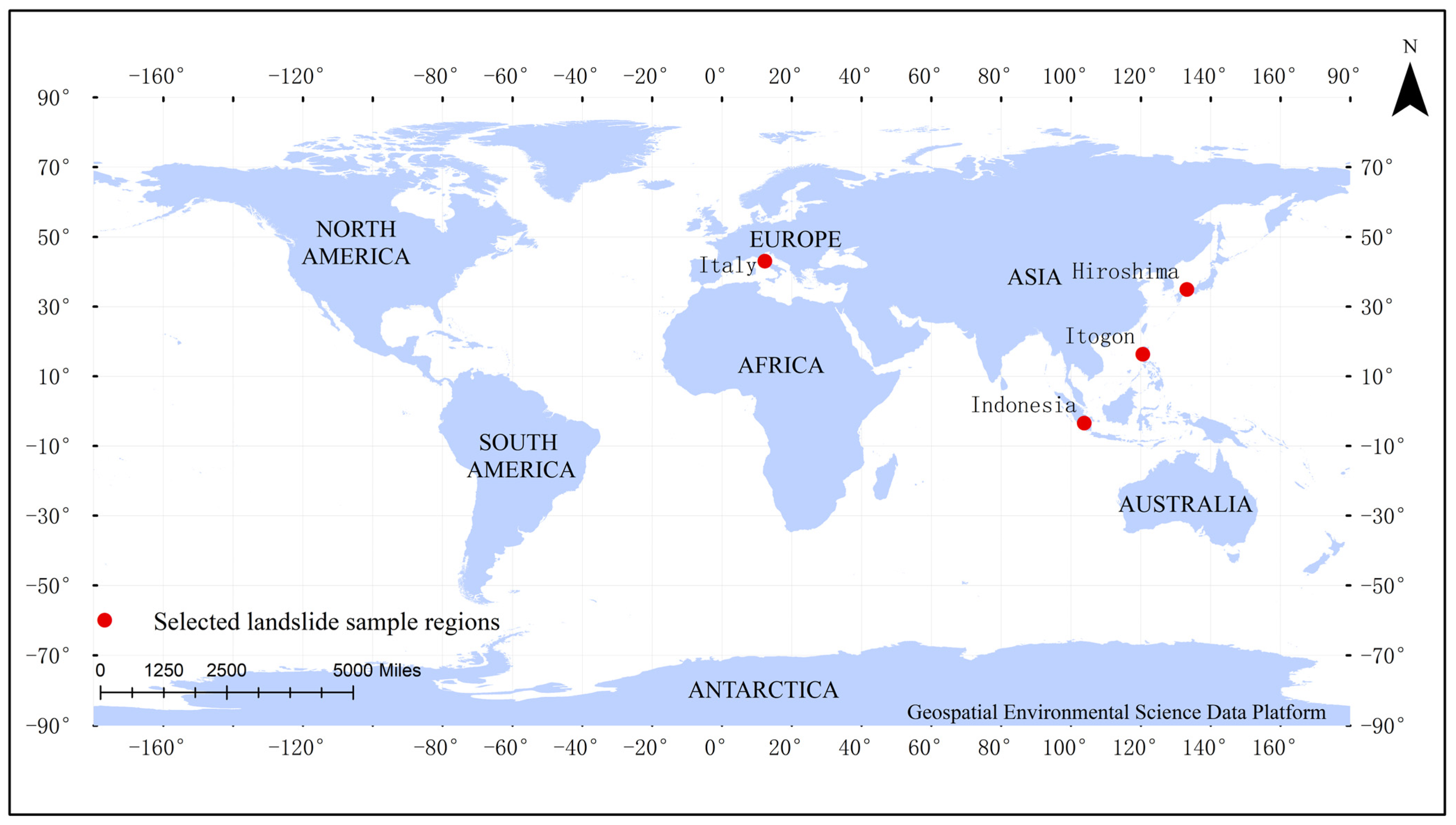
2.1. Landslide Sample Areas and Dataset
2.2. Landslide Detection Model: ConFormer-Net
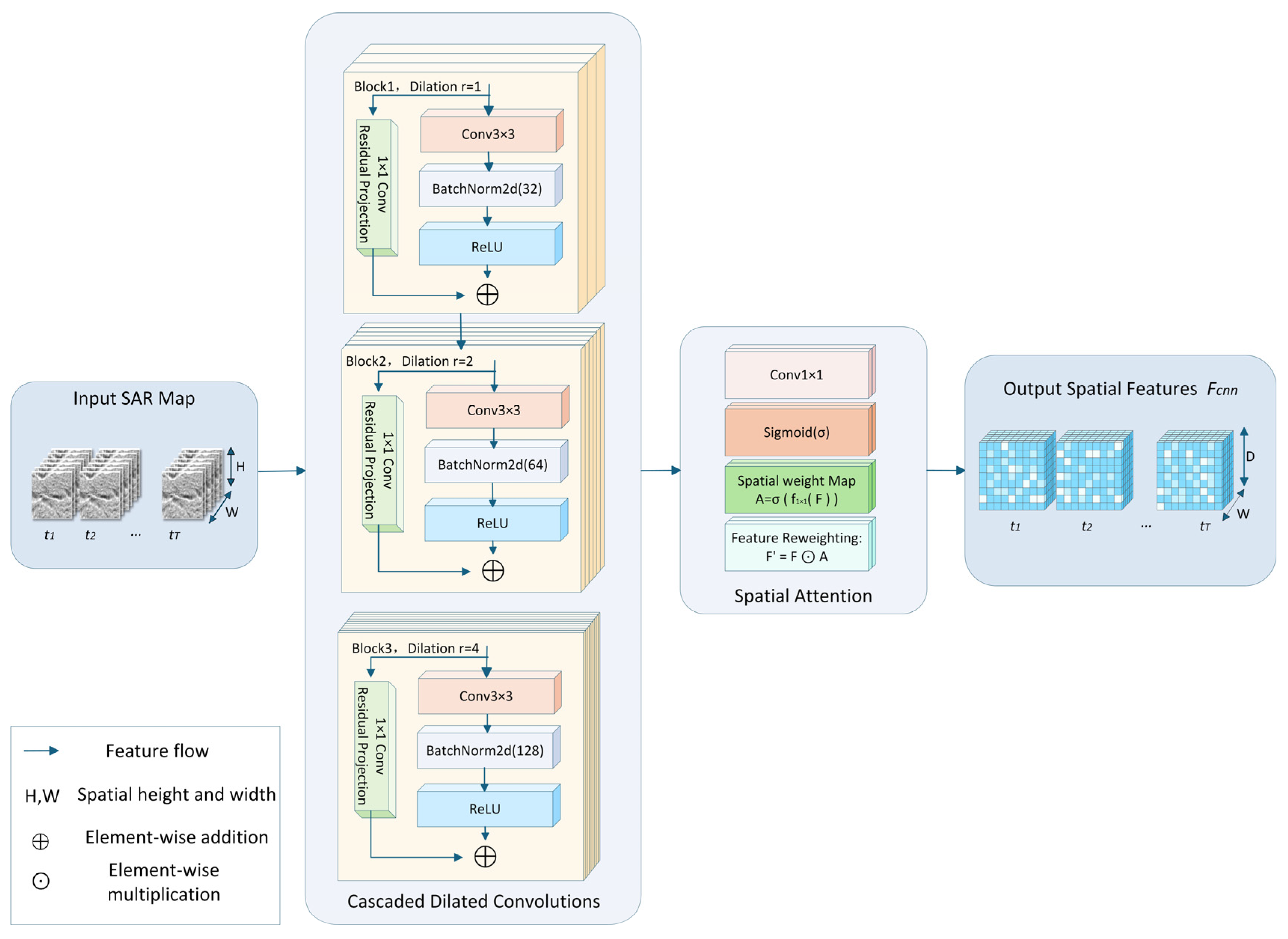
2.2.1. Multiscale Spatial Feature Extraction Module Based on Dilated Convolution
2.2.2. Pixel-Level Temporal Modeling and Positional Encoding Mechanism
2.2.3. Spatiotemporal Feature Fusion Mechanism Based on Cross-Attention
2.2.4. Lightweight Convolutional Decoder for Pixel-Wise Semantic Segmentation
3. Results and Analysis
3.1. Experimental Setting and Evaluation Metrics
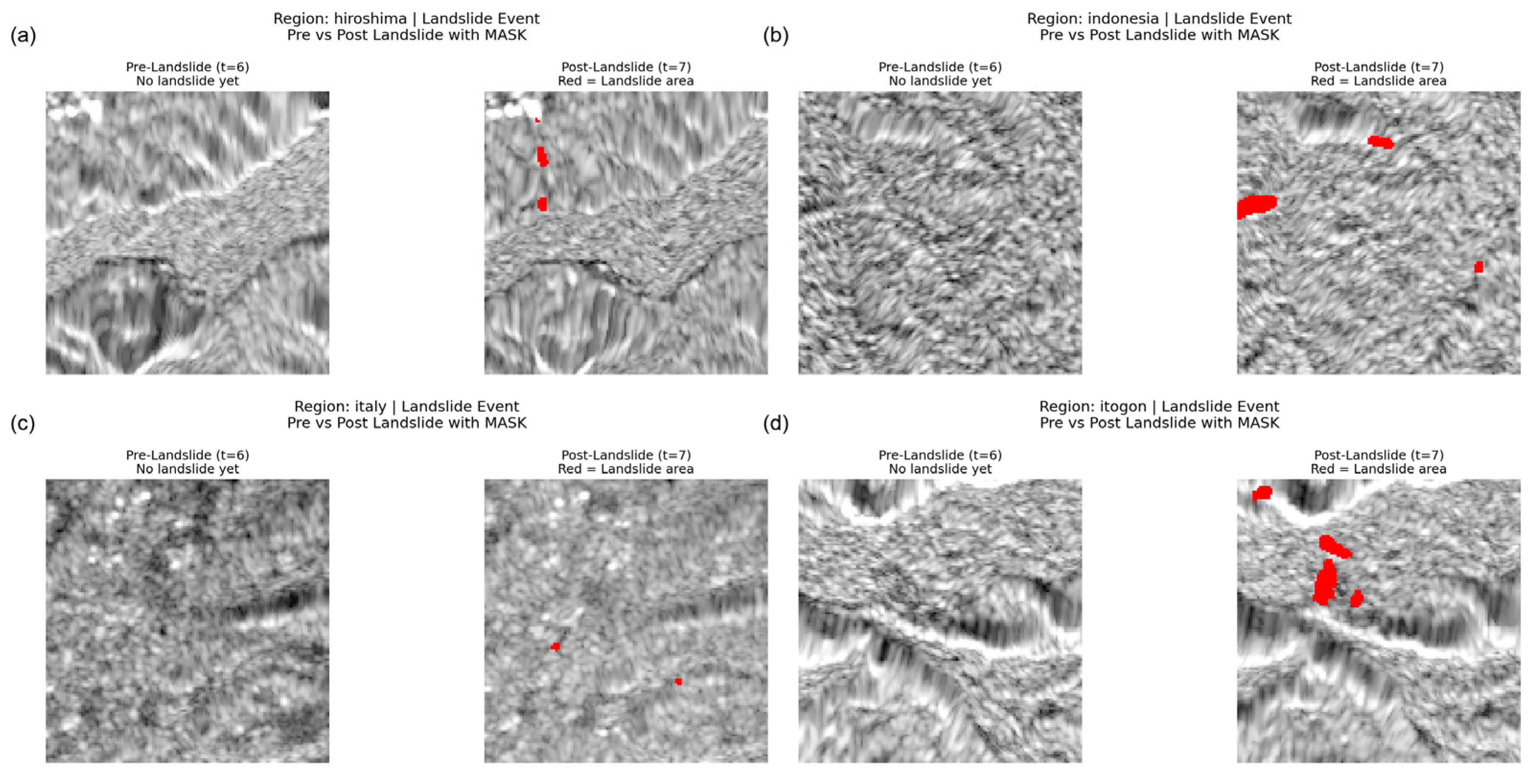
3.2. Visualization of Multi-Temporal SAR Samples
3.3. Comparative Experiments
3.4. Leave-One-Region-Out Experiment
3.5. Temporal Shift Experiment
3.6. First Post-Event Acquisition Experiment
3.7. Ablation Experiment
4. Discussion
4.1. Spatiotemporal Joint Modeling Enhances the Discrimination Between Landslide-Induced Changes and Background Disturbances
4.2. The Critical Role of Temporal Dependency Modeling in Improving Model Performance
4.3. The Incremental Optimization Effect of Cross-Attention on Spatiotemporal Feature Fusion
4.4. Limitations and Future Work
5. Conclusions
Author Contributions
Funding
Institutional Review Board Statement
Informed Consent Statement
Data Availability Statement
Conflicts of Interest
References
- Keefer, D.K.; Larsen, M.C. Assessing landslide hazards. Science 2007, 316, 1136–1138. [Google Scholar] [CrossRef] [Scilit] [PubMed]
- Geertsema, M.; Highland, L.; Vaugeouis, L. Environmental impact of landslides. In Landslides–Disaster Risk Reduction; Springer: Berlin/Heidelberg, Germany, 2009; pp. 589–607. [Google Scholar]
- Alcántara-Ayala, I. Landslides in a changing world. Landslides 2025, 22, 2851–2865. [Google Scholar] [CrossRef] [Scilit]
- Qiu, H.; Su, L.; Tang, B.; Yang, D.; Ullah, M.; Zhu, Y.; Kamp, U. The effect of location and geometric properties of landslides caused by rainstorms and earthquakes. Earth Surf. Process. Landf. 2024, 49, 2067–2079. [Google Scholar] [CrossRef] [Scilit]
- KC, R.; Sharma, K.; Dahal, B.K.; Aryal, M.; Subedi, M. Study of the spatial distribution and the temporal trend of landslide disasters that occurred in the Nepal Himalayas from 2011 to 2020. Environ. Earth Sci. 2024, 83, 42. [Google Scholar] [CrossRef] [Scilit]
- Leshchinsky, B.A.; Olsen, M.J.; Tanyu, B.F. Contour Connection Method for automated identification and classification of landslide deposits. Comput. Geosci. 2015, 74, 27–38. [Google Scholar] [CrossRef] [Scilit]
- Komac, M.; Holley, R.; Mahapatra, P.; van der Marel, H.; Bavec, M. Coupling of GPS/GNSS and radar interferometric data for a 3D surface displacement monitoring of landslides. Landslides 2015, 12, 241–257. [Google Scholar] [CrossRef] [Scilit]
- Fiorucci, F.; Ardizzone, F.; Mondini, A.C.; Viero, A.; Guzzetti, F. Visual interpretation of stereoscopic NDVI satellite images to map rainfall-induced landslides. Landslides 2019, 16, 165–174. [Google Scholar] [CrossRef] [Scilit]
- Mondini, A.C.; Guzzetti, F.; Chang, K.-T.; Monserrat, O.; Martha, T.R.; Manconi, A. Landslide failures detection and mapping using Synthetic Aperture Radar: Past, present and future. Earth-Sci. Rev. 2021, 216, 103574. [Google Scholar] [CrossRef] [Scilit]
- Guo, R.; Li, S.; Chen, Y.n.; Li, X.; Yuan, L. Identification and monitoring landslides in Longitudinal Range-Gorge Region with InSAR fusion integrated visibility analysis. Landslides 2021, 18, 551–568. [Google Scholar] [CrossRef] [Scilit]
- Meng, L.; Yan, C.; Lv, S.; Sun, H.; Xue, S.; Li, Q.; Zhou, L.; Edwing, D.; Edwing, K.; Geng, X. Synthetic aperture radar for geosciences. Rev. Geophys. 2024, 62, e2023RG000821. [Google Scholar] [CrossRef] [Scilit]
- Cai, J.; Liu, G.; Jia, H.; Zhang, B.; Wu, R.; Fu, Y.; Xiang, W.; Mao, W.; Wang, X.; Zhang, R. A new algorithm for landslide dynamic monitoring with high temporal resolution by Kalman filter integration of multiplatform time-series InSAR processing. Int. J. Appl. Earth Obs. Geoinf. 2022, 110, 102812. [Google Scholar] [CrossRef] [Scilit]
- Sun, Q.; Zhang, L.; Ding, X.; Hu, J.; Li, Z.; Zhu, J. Slope deformation prior to Zhouqu, China landslide from InSAR time series analysis. Remote Sens. Environ. 2015, 156, 45–57. [Google Scholar] [CrossRef] [Scilit]
- Chen, B.; Li, Z.; Song, C.; Tomás, R.; Yu, C.; Zhu, W.; Peng, J. Unveiling the long-term cascading effects of the 2018 Baige landslide and subsequent outburst flood with satellite radar observations. Remote Sens. Environ. 2026, 334, 115231. [Google Scholar] [CrossRef] [Scilit]
- Cook, M.E.; Brook, M.S.; Hamling, I.J.; Cave, M.; Tunnicliffe, J.F.; Holley, R. Investigating slow-moving shallow soil landslides using Sentinel-1 InSAR data in Gisborne, New Zealand. Landslides 2023, 20, 427–446. [Google Scholar] [CrossRef] [Scilit]
- Deng, Z.; Wang, W.; Luo, Y.; Zhang, S.; Xu, L.; Su, Q. Slope deformation monitoring and prediction based on InSAR and deep learning model. Results Eng. 2025, 28, 107113. [Google Scholar] [CrossRef] [Scilit]
- Nava, L.; Mondini, A.; Bhuyan, K.; Fang, C.; Monserrat, O.; Novellino, A.; Catani, F. Sentinel-1 SAR-based globally distributed co-seismic landslide detection by deep neural networks. Geosci. Model Dev. Discuss. 2025, 2025, 1–29. [Google Scholar] [CrossRef] [Scilit]
- Shi, W.; Zhang, M.; Ke, H.; Fang, X.; Zhan, Z.; Chen, S. Landslide recognition by deep convolutional neural network and change detection. IEEE Trans. Geosci. Remote Sens. 2020, 59, 4654–4672. [Google Scholar] [CrossRef] [Scilit]
- Zhou, C.; Ye, M.; Xia, Z.; Wang, W.; Luo, C.; Muller, J.-P. An interpretable attention-based deep learning method for landslide prediction based on multi-temporal InSAR time series: A case study of Xinpu landslide in the TGRA. Remote Sens. Environ. 2025, 318, 114580. [Google Scholar] [CrossRef] [Scilit]
- Sun, H.; Yang, S.; Wang, R.; Yang, K. Study on a landslide segmentation algorithm based on improved high-resolution networks. Appl. Sci. 2024, 14, 6459. [Google Scholar] [CrossRef] [Scilit]
- Cai, J.; Zhang, L.; Dong, J.; Guo, J.; Wang, Y.; Liao, M. Automatic identification of active landslides over wide areas from time-series InSAR measurements using Faster RCNN. Int. J. Appl. Earth Obs. Geoinf. 2023, 124, 103516. [Google Scholar] [CrossRef] [Scilit]
- Liu, Y.; Yao, X.; Gu, Z.; Li, R.; Zhou, Z.; Liu, X.; Jiang, S.; Yao, C.; Wei, S. Research on automatic recognition of active landslides using InSAR deformation under digital morphology: A case study of the Baihetan reservoir, China. Remote Sens. Environ. 2024, 304, 114029. [Google Scholar] [CrossRef] [Scilit]
- Alzubaidi, L.; Zhang, J.; Humaidi, A.J.; Al-Dujaili, A.; Duan, Y.; Al-Shamma, O.; Santamaría, J.; Fadhel, M.A.; Al-Amidie, M.; Farhan, L. Review of deep learning: Concepts, CNN architectures, challenges, applications, future directions. J. Big Data 2021, 8, 53. [Google Scholar] [CrossRef] [Scilit] [PubMed]
- Lihao, D.; Yanhui, L.; Junbao, H.; Haining, L. An early prediction model of regional landslide disasters in Fujian Province based on convolutional neural network. Hydrogeol. Eng. Geol. 2024, 51, 145–153. [Google Scholar]
- Tai, Y.-H.; Lo, C.-C.; Tsai, F.; Chang, C.-P. Application of PSInSAR Monitoring for Large-Scale Landslide with Persistent Scatterers from Deep Learning Classification. Remote Sens. 2026, 18, 1181. [Google Scholar] [CrossRef] [Scilit]
- Yi, Y.; Zhang, W. A new deep-learning-based approach for earthquake-triggered landslide detection from single-temporal RapidEye satellite imagery. IEEE J. Sel. Top. Appl. Earth Obs. Remote Sens. 2020, 13, 6166–6176. [Google Scholar] [CrossRef] [Scilit]
- Ghorbanzadeh, O.; Crivellari, A.; Ghamisi, P.; Shahabi, H.; Blaschke, T. A comprehensive transferability evaluation of U-Net and ResU-Net for landslide detection from Sentinel-2 data (case study areas from Taiwan, China, and Japan). Sci. Rep. 2021, 11, 14629. [Google Scholar] [CrossRef] [Scilit] [PubMed]
- Cai, H.; Chen, T.; Niu, R.; Plaza, A. Landslide detection using densely connected convolutional networks and environmental conditions. IEEE J. Sel. Top. Appl. Earth Obs. Remote Sens. 2021, 14, 5235–5247. [Google Scholar] [CrossRef] [Scilit]
- Liu, T.; Chen, T.; Niu, R.; Plaza, A. Landslide detection mapping employing CNN, ResNet, and DenseNet in the three gorges reservoir, China. IEEE J. Sel. Top. Appl. Earth Obs. Remote Sens. 2021, 14, 11417–11428. [Google Scholar] [CrossRef] [Scilit]
- Kumar, A.; Misra, R.; Singh, T.; Singh, V. Landslide detection with Ensemble-of-Deep learning classifiers trained with optimal features. In Proceedings of the XVIII International Conference on Data Science and Intelligent Analysis of Information, Mumbai, India, 23–24 April 2022; pp. 313–322. [Google Scholar]
- Ruan, Q.; Miao, F.; Wu, Y.; Yang, B.; Zhao, F.; Zhan, W. Hybrid prediction for reservoir landslide deformation based on multi-source InSAR and deep learning. Bull. Eng. Geol. Environ. 2025, 84, 290. [Google Scholar] [CrossRef] [Scilit]
- Chen, Y.; He, Y.; Zhang, L.; Chen, Y.; Pu, H.; Chen, B.; Gao, L. Prediction of InSAR deformation time-series using a long short-term memory neural network. Int. J. Remote Sens. 2021, 42, 6919–6942. [Google Scholar] [CrossRef] [Scilit]
- Zhu, H.; Shen, Q.; Li, J.; Gulayozov, M.; Shao, Y.; Chen, B.; Zhu, C. Deformation Prediction and Potential Landslide Identification in the Upstream of Sarez Lake Based on Time Series InSAR and Stacked LSTM. Remote Sens. 2026, 18, 811. [Google Scholar] [CrossRef] [Scilit]
- Ge, Q.; Li, J.; Wang, X.; Deng, Y.; Zhang, K.; Sun, H. LiteTransNet: An interpretable approach for landslide displacement prediction using transformer model with attention mechanism. Eng. Geol. 2024, 331, 107446. [Google Scholar] [CrossRef] [Scilit]
- Cui, X.; Chen, X.; Zhou, J.; Lin, D. Transformer in image interpretation. In Proceedings of the International Conference on Computer Graphics, Artificial Intelligence, and Data Processing (ICCAID 2021), Harbin, China, 24–26 December 2021; pp. 45–50. [Google Scholar]
- Sreelakshmi, S.; Chandra, S.V. A Hybrid Fusion Network using Convolutional Vision Transformers for Landslide Identification. Expert Syst. Appl. 2025, 298, 129688. [Google Scholar] [CrossRef] [Scilit]
- Li, Y.; Xue, Y.; Xin, Z.; Liao, G.; Huang, P. Multi-modal cross Swin transformer network for multi-label classification landslide detection with optical and SAR images of Luding. Int. J. Appl. Earth Obs. Geoinf. 2025, 145, 104954. [Google Scholar] [CrossRef] [Scilit]
- Bazi, Y.; Bashmal, L.; Rahhal, M.M.A.; Dayil, R.A.; Ajlan, N.A. Vision transformers for remote sensing image classification. Remote Sens. 2021, 13, 516. [Google Scholar] [CrossRef] [Scilit]
- Dufter, P.; Schmitt, M.; Schütze, H. Position information in transformers: An overview. Comput. Linguist. 2022, 48, 733–763. [Google Scholar] [CrossRef] [Scilit]
- Zhang, C.; Jiang, W.; Zhang, Y.; Wang, W.; Zhao, Q.; Wang, C. Transformer and CNN hybrid deep neural network for semantic segmentation of very-high-resolution remote sensing imagery. IEEE Trans. Geosci. Remote Sens. 2022, 60, 4408820. [Google Scholar] [CrossRef] [Scilit]
- Deng, P.; Xu, K.; Huang, H. When CNNs meet vision transformer: A joint framework for remote sensing scene classification. IEEE Geosci. Remote Sens. Lett. 2021, 19, 8020305. [Google Scholar] [CrossRef] [Scilit]
- Perera, M.V.; Bandara, W.G.C.; Valanarasu, J.M.J.; Patel, V.M. Transformer-based SAR image despeckling. In Proceedings of the IGARSS 2022-2022 IEEE International Geoscience and Remote Sensing Symposium, Kuala Lumpur, Malaysia, 17–22 July 2022; pp. 751–754. [Google Scholar]
- Höhn, P.; Heidler, K.; Behling, R.; Zhu, X.X. A Spatio-Temporal Dataset for Satellite-Based Landslide Detection. Sci. Data 2025, 12, 1772. [Google Scholar] [CrossRef] [Scilit] [PubMed]
- Zhang, Q. A novel ResNet101 model based on dense dilated convolution for image classification. SN Appl. Sci. 2022, 4, 9. [Google Scholar] [CrossRef] [Scilit]
- Foumani, N.M.; Tan, C.W.; Webb, G.I.; Salehi, M. Improving position encoding of transformers for multivariate time series classification. arXiv 2023, arXiv:2305.16642. [Google Scholar]
- Qingyun, F.; Zhaokui, W. Cross-modality attentive feature fusion for object detection in multispectral remote sensing imagery. Pattern Recognit. 2022, 130, 108786. [Google Scholar] [CrossRef] [Scilit]
- Lindsay, E.; Ganerød, A.J.; Devoli, G.; Reiche, J.; Nordal, S.; Frauenfelder, R. Understanding landslide expression in SAR backscatter data: Global study and disaster response application. Remote Sens. 2025, 17, 3313. [Google Scholar] [CrossRef] [Scilit]
- Wang, W.; Motagh, M.; Xia, Z.; Plank, S.; Li, Z.; Orynbaikyzy, A.; Zhou, C.; Roessner, S. A framework for automated landslide dating utilizing SAR-derived parameters time-series, an enhanced transformer model, and dynamic thresholding. Int. J. Appl. Earth Obs. Geoinf. 2024, 129, 103795. [Google Scholar] [CrossRef] [Scilit]







| Region | Total Number of Samples | Number of Landslide Samples | Number of Non-Landslide Samples | Proportion of Landslide Samples (%) | Landslide Pixels (%) | Non-Landslide Pixels (%) |
|---|---|---|---|---|---|---|
| Hiroshima | 864 | 457 | 407 | 52.9 | 6.8 | 93.2 |
| Indonesia | 622 | 311 | 311 | 50.0 | 5.1 | 94.9 |
| Italy | 4576 | 2258 | 2318 | 49.3 | 4.2 | 95.8 |
| Itogon | 228 | 125 | 103 | 54.8 | 7.5 | 92.5 |
| Total | 6290 | 3151 | 3139 | 50.1 | 4.8 | 95.2 |
| Devices | Configuration |
|---|---|
| Operating system | Ubuntu 22.04 |
| CPU | Intel(®) Xeon(®) Gold 6130 CPU @ 2.10 GHz (6 vCPUs) |
| GPU | NVIDIA V100 |
| GPU memory size | 32 GB |
| Deep learning framework | PyTorch(2.3.1) |
| Landslide Size | Area (m2) | F1-Score (%) | Boundary F1-Score (%) |
|---|---|---|---|
| Small | <1000 | 91.20 | 82.50 |
| Medium | 1000–5000 | 95.50 | 87.30 |
| Large | >5000 | 96.80 | 90.10 |
| Model | F1 (%) | Accuracy (%) | Precision (%) | Recall (%) | p-Value |
|---|---|---|---|---|---|
| CNN | 85.21 ± 0.32 | 82.95 ± 0.41 | 75.65 ± 0.58 | 97.55 ± 0.29 | p < 0.0001 |
| CNN-LSTM | 93.68 ± 0.15 | 93.60 ± 0.18 | 93.68 ± 0.22 | 93.68 ± 0.19 | p < 0.0001 |
| ConvLSTM | 92.30 ± 0.24 | 92.60 ± 0.20 | 97.35 ± 0.15 | 87.70 ± 0.35 | p < 0.0001 |
| GRU | 93.45 ± 0.18 | 93.47 ± 0.21 | 94.65 ± 0.25 | 92.25 ± 0.28 | p < 0.0001 |
| CNN3D | 92.30 ± 0.28 | 92.32 ± 0.30 | 93.50 ± 0.20 | 91.12 ± 0.32 | p < 0.0001 |
| ResNet50 | 87.50 ± 28 | 85.60 ± 33 | 80.20 ± 45 | 96.30 ± 26 | p < 0.0001 |
| ConFormer-Net | 95.35 ± 0.08 | 95.37 ± 0.09 | 96.85 ± 0.12 | 93.85 ± 0.14 | — |
| Model | Parameters | FLOPs (G) | Inference Time (ms/Sample) | Training Time (h/Run) | Peak GPU Memory (MB) |
|---|---|---|---|---|---|
| CNN | 105 K | 0.52 | 4.8 | 1.0 | 1280 |
| CNN-LSTM | 366 K | 2.85 | 17.2 | 4.2 | 3050 |
| ConvLSTM | 319 K | 3.56 | 22.5 | 5.6 | 3520 |
| GRU | 300 K | 2.43 | 15.8 | 3.9 | 2880 |
| CNN3D | 287 K | 4.18 | 19.8 | 5.1 | 3380 |
| ResNet50 | 850 K | 1.82 | 10.3 | 2.2 | 2150 |
| ConFormer-Net | 802 K | 7.63 | 31.4 | 7.8 | 5420 |
| Held-Out Region | F1-Score (%) | Precision (%) | Recall (%) | IoU (%) | Dice (%) | Specificity (%) | FPR (%) |
|---|---|---|---|---|---|---|---|
| Hiroshima | 93.52 | 95.10 | 92.00 | 87.82 | 93.52 | 99.21 | 0.79 |
| Indonesia | 91.85 | 93.40 | 90.40 | 84.97 | 91.85 | 98.95 | 1.05 |
| Italy | 94.68 | 96.20 | 93.20 | 89.88 | 94.68 | 99.42 | 0.58 |
| Itogon | 90.10 | 92.00 | 88.30 | 82.03 | 90.10 | 98.72 | 1.28 |
| Average | 92.54 | 94.18 | 90.98 | 86.18 | 92.54 | 99.08 | 0.93 |
| Assumed Event Time | F1-Score (%) | Precision (%) | Recall (%) |
|---|---|---|---|
| Original (t = 7) | 95.27 | 96.79 | 93.79 |
| Shifted (t = 4) | 94.85 | 96.50 | 93.25 |
| Shifted (t = 5) | 94.91 | 96.55 | 93.30 |
| Input Configuration | F1-Score (%) | Precision (%) | Recall (%) |
|---|---|---|---|
| Single Post-Event (t = 7) | 86.25 | 88.10 | 84.50 |
| Full Sequence | 95.27 | 96.79 | 93.79 |
| Model | Params (K) | F1-Score (%) | Accuracy (%) | Precision (%) | Recall (%) |
|---|---|---|---|---|---|
| Full Model (Ours) | 802 | 95.27 | 95.29 | 96.79 | 93.79 |
| Core Module Ablation | |||||
| w/o cross-attention (concatenation) | 769 | 95.12 | 95.10 | 96.50 | 93.60 |
| w/o cross-attention (summation) | 769 | 95.20 | 95.18 | 96.62 | 93.68 |
| w/o cross-attention (gated fusion) | 774 | 95.15 | 95.12 | 96.55 | 93.65 |
| w/o temporal modeling | 105 | 86.89 | 85.43 | 85.00 | 95.48 |
| temporal: uni-LSTM | 383 | 90.83 | 90.71 | 90.00 | 90.96 |
| Spatial Component Ablation | |||||
| w/o dilated convolution (r = 1 only) | 798 | 94.20 | 94.18 | 95.80 | 92.65 |
| w/o spatial attention | 798 | 94.85 | 94.82 | 96.15 | 93.58 |
| different dilation rates (e.g., 1, 2, 8) | 802 | 95.10 | 95.08 | 96.58 | 93.52 |
| different dilation rates (e.g., 1, 3, 5) | 802 | 95.05 | 95.03 | 96.50 | 93.45 |
| Temporal Component Ablation | |||||
| w/o positional encoding | 802 | 94.78 | 94.75 | 96.20 | 93.40 |
| shorter sequence (e.g., T = 10) | 802 | 94.45 | 94.40 | 95.90 | 93.02 |
| shorter sequence (e.g., T = 5) | 802 | 92.10 | 92.05 | 93.80 | 90.45 |
| Decoder Ablation | |||||
| single-layer decoder | 625 | 94.60 | 94.55 | 95.90 | 93.32 |
| heavier decoder (U-Net-like) | 1150 | 95.31 | 95.33 | 96.85 | 93.82 |
Disclaimer/Publisher’s Note: The statements, opinions and data contained in all publications are solely those of the individual author(s) and contributor(s) and not of MDPI and/or the editor(s). MDPI and/or the editor(s) disclaim responsibility for any injury to people or property resulting from any ideas, methods, instructions or products referred to in the content. |
© 2026 by the authors. Licensee MDPI, Basel, Switzerland. This article is an open access article distributed under the terms and conditions of the Creative Commons Attribution (CC BY) license.
Share and Cite
Lan, S.; Wu, D.; Lu, P.; Guo, B.; Li, Z. ConFormer-Net: Spatiotemporal Modeling for Landslide Detection Using Multi-Temporal SAR Data. Sensors 2026, 26, 5943. https://doi.org/10.3390/s26185943
Lan S, Wu D, Lu P, Guo B, Li Z. ConFormer-Net: Spatiotemporal Modeling for Landslide Detection Using Multi-Temporal SAR Data. Sensors. 2026; 26(18):5943. https://doi.org/10.3390/s26185943
Chicago/Turabian StyleLan, Shaofei, Daming Wu, Peng Lu, Beinan Guo, and Zixiao Li. 2026. "ConFormer-Net: Spatiotemporal Modeling for Landslide Detection Using Multi-Temporal SAR Data" Sensors 26, no. 18: 5943. https://doi.org/10.3390/s26185943
APA StyleLan, S., Wu, D., Lu, P., Guo, B., & Li, Z. (2026). ConFormer-Net: Spatiotemporal Modeling for Landslide Detection Using Multi-Temporal SAR Data. Sensors, 26(18), 5943. https://doi.org/10.3390/s26185943