

Technical Design of a Low-Latitude Satellite Constellation for Ocean Observation with a Focus on Hainan Province, China


 and
and 
Abstract
1. Introduction
2. Constellation Design
2.1. Mission Aims and Technical Requirements
2.2. Constellation Technical Characteristics
2.2.1. A Low-Latitude Satellite Constellation
2.2.2. Design Concept of Coverage Priority
2.2.3. Synergy of Sensors with Multispectral, Hyperspectral, SAR and Ship AIS
2.2.4. Onboard Image Processing Technology and Dual-Line Array Delay System for Ship Detection
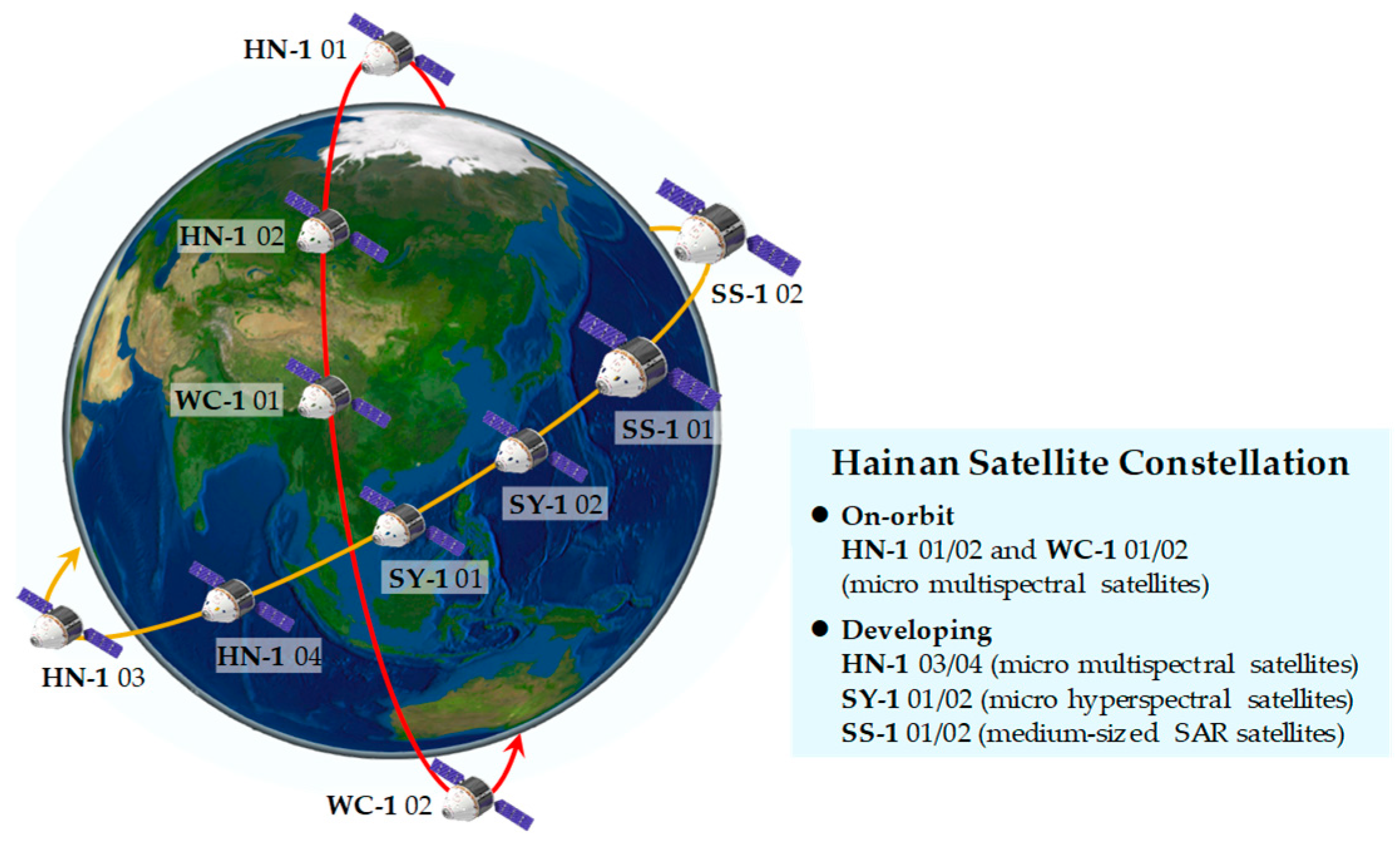
2.3. Constellation Composition
2.4. Constellation Capacity
3. Constellation Construction
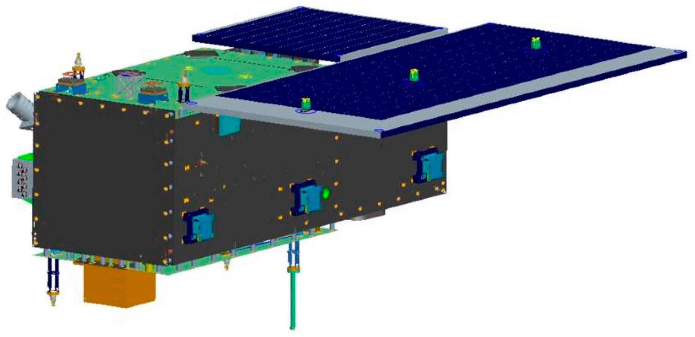
3.1. Construction of the Satellite
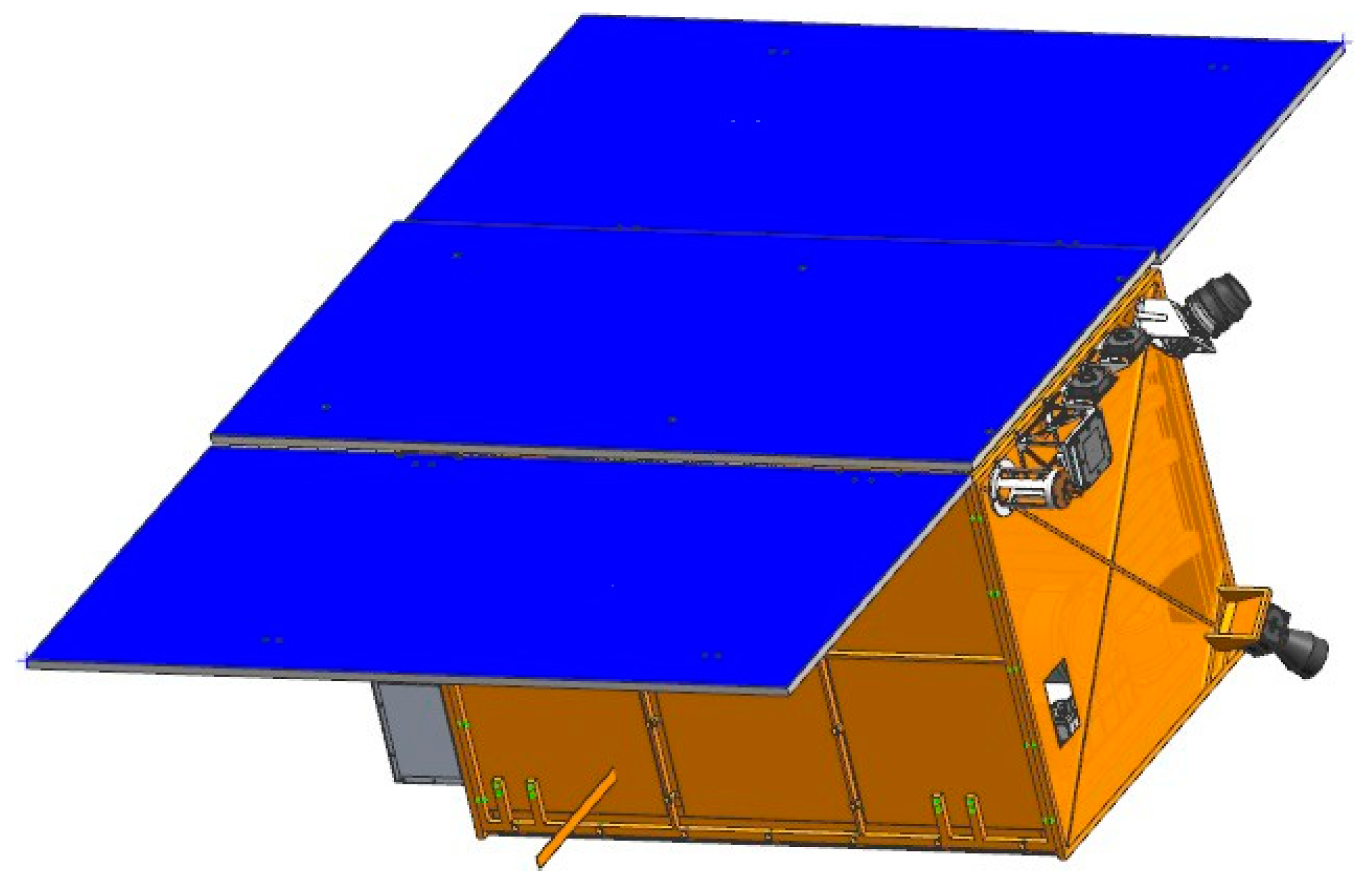
3.2. Payload
3.3. Construction of the Ground System
4. Application Characteristics
4.1. Satellite Networking for Observation of Large Ocean Areas
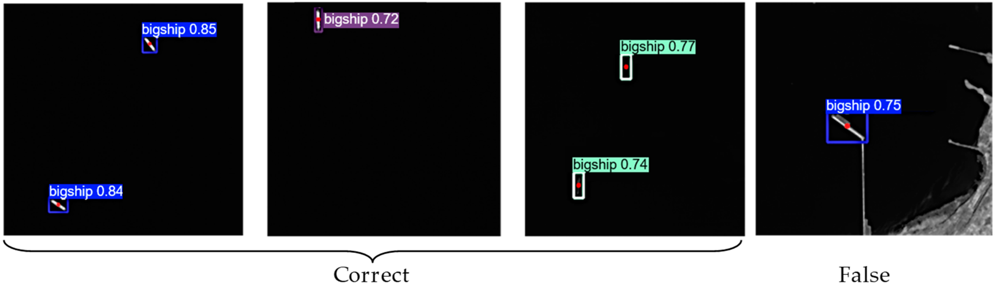
4.2. Onboard Image Processing and the YOLO Model for Ship Detection
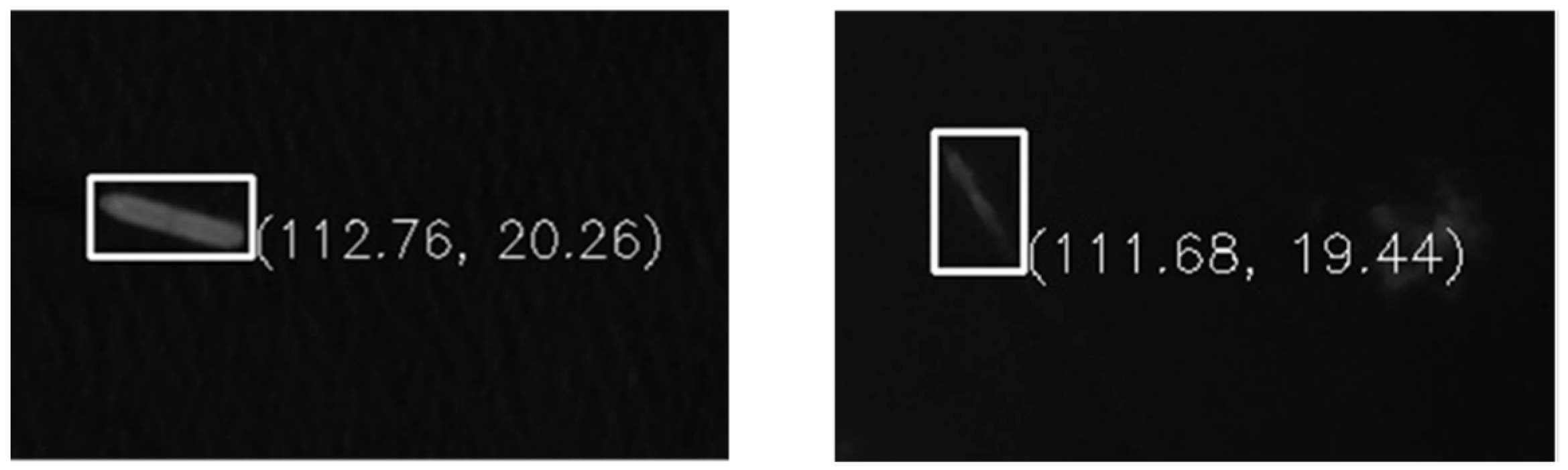
4.2.1. Dual-Line Array Delay Imaging System
4.2.2. Ship Detection with YOLOv5 Model
4.3. Synergy of Onboard Sensors with Optical Camera and Ship AIS
4.4. Other Application Fields
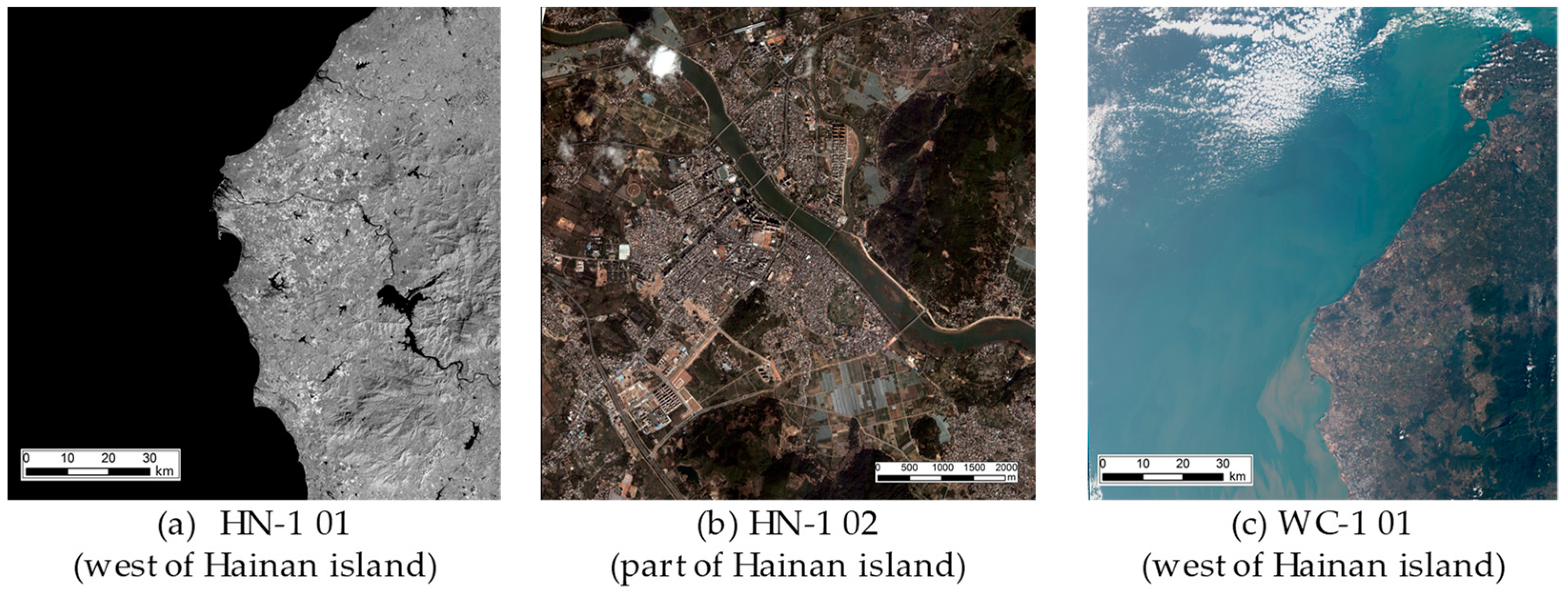
4.5. Application Cases
5. Follow-Up Development Plan
6. Conclusions
Author Contributions
Funding
Institutional Review Board Statement
Informed Consent Statement
Data Availability Statement
Conflicts of Interest
References
- Sanad, I.; Vali, Z.; Michelson, D.G. Statistical classification of remote sensing satellite constellations. In Proceeding of the IEEE Aerospace Conference, Big Sky, MT, USA, 7–14 March 2020; pp. 1–15. [Google Scholar]
- Wang, K.; Franklin, S.E.; Guo, X.; Cattet, M. Remote sensing of ecology, biodiversity and conservation: A review from the perspective of remote sensing specialists. Sensors 2010, 10, 9647–9667. [Google Scholar] [CrossRef] [PubMed]
- Xue, Y.; Li, Y.; Guang, J.; Zhang, X.; Guo, J. Small satellite remote sensing and applications—History, current and future. Int. J. Remote Sens. 2008, 29, 4339–4372. [Google Scholar] [CrossRef]
- Boukabara, S.-A.; Eyre, J.; Anthes, R.A.; Holmlund, K.; Germain, K.M.S.; Hoffman, R.N. The Earth-observing satellite constellation: A review from a meteorological perspective of a complex, interconnected global system with extensive applications. IEEE Geosci. Remote Sens. Mag. 2021, 9, 26–42. [Google Scholar] [CrossRef]
- Toth, C.; Jóźków, G.G. Remote sensing platforms and sensors: A survey. ISPRS J. Photogramm. Remote Sens. 2016, 115, 22–36. [Google Scholar] [CrossRef]
- Zhao, Q.; Pan, J.; Devlin, A.T.; Tang, M.; Yao, C.; Zamparelli, V.; Falabella, F.; Pepe, A. On the exploitation of remote sensing technologies for the monitoring of coastal and river delta regions. Remote Sens. 2022, 14, 2384. [Google Scholar] [CrossRef]
- Rashed, M.I.; Bang, H. A study of autonomous small satellite constellations for disaster management and deep space strategy. Remote Sens. 2022, 14, 6148. [Google Scholar] [CrossRef]
- Chadalavada, P.; Dutta, A. Regional CubeSat constellation design to monitor hurricanes. IEEE Trans. Geosci. Remote Sens. 2022, 60, 1–8. [Google Scholar] [CrossRef]
- Mostert, S.; Jacobs, M. ARM constellation—Establishing a regional remote sensing asset. Acta Astronaut. 2008, 63, 221–227. [Google Scholar] [CrossRef]
- Vasudha, M.P.; Raju, G. Tropical cyclones over the Arabian Sea and Bay of Bengal tracked by Megha-Tropiques SAPHIR during 2011–2018. J. Earth Syst. Sci. 2019, 128, 91. [Google Scholar] [CrossRef]
- Varma, A.K.; Piyush, D.N.; Gohil, B.S.; Pal, P.K.; Srinivasan, J. Rain detection and measurement from Megha-Tropiques microwave sounder—SAPHIR. J. Geophys. Res. Atmos. 2016, 121, 9191–9207. [Google Scholar] [CrossRef]
- Clarizia, M.P.; Pierdicca, N.; Costantini, F.; Floury, N. Analysis of CYGNSS data for soil moisture retrieval. IEEE J. Sel. Topics Appl. Earth Observ. Remote Sens. 2019, 12, 2227–2235. [Google Scholar] [CrossRef]
- Al-Khaldi, M.M.; Johnson, J.T.; O’Brien, A.J.; Balenzano, A.; Mattia, F. Time-series retrieval of soil moisture using CYGNSS. IEEE Trans. Geosci. Remote Sens. 2019, 57, 4322–4331. [Google Scholar] [CrossRef]
- Stilla, D.; Zribi, M.; Pierdicca, N.; Baghdadi, N.; Huc, M. Desert roughness retrieval using CYGNSS GNSS-R data. Remote Sens. 2020, 12, 743. [Google Scholar] [CrossRef]
- Blackwell, W.J.; Braun, S.; Bennartz, R.; Velden, C.; DeMaria, M.; Atlas, R.; Dunion, J.; Marks, F.; Rogers, R.; Annane, B.; et al. An overview of the TROPICS NASA earth venture mission. Q. J. R. Meteor. Soc. 2018, 144, 16–26. [Google Scholar] [CrossRef]
- Simpson, J.; Kummerow, C.; Tao, W.K.; Adler, R.F. On the tropical rainfall measuring mission (TRMM). Meteorol. Atmos. Phys. 1996, 60, 19–36. [Google Scholar] [CrossRef]
- Bindlish, R.; Jackson, T.J.; Wood, E.; Gao, H.; Starks, P.; Bosch, D.; Lakshmi, V. Soil moisture estimates from TRMM Microwave Imager observations over the Southern United States. Remote Sens. Environ. 2003, 85, 507–515. [Google Scholar] [CrossRef]
- Fu, Y.; Liu, G. Precipitation characteristics in mid-latitude East Asia as observed by TRMM PR and TMI. J. Meteorol. Soc. Jpn. 2003, 81, 1353–1369. [Google Scholar] [CrossRef]
- Hasbi, W. LAPAN-A2 (IO-86) satellite roles in natural disaster in Indonesia. In Proceeding of the 70th International Astronautical Congress (IAC), Washington, DC, USA, 21–25 October 2019; pp. 1–5. [Google Scholar]
- Herawan, A.; Hakim, P.R.; Anggari, E.A.; Wahyudiono, A.; Rachim, E.; Soedjarwo, M. Utilisation of LAPAN-A2 satellite digital spacecam imagery for natural disaster monitoring. In Proceedings of the AIP Conference Proceedings, Malang, Indonesia, 9–10 August 2022; Volume 3106, p. 020009. [Google Scholar]
- Desai, S.D.; Haines, B.J. Near-real–time GPS-based orbit determination and sea surface height observations from the Jason-1 mission special issue: Jason-1 calibration/validation. Mar. Geod. 2003, 26, 383–397. [Google Scholar] [CrossRef]
- Hsiao, Y.-S.; Hwang, C.; Chen, T.-W.; Cho, Y.-H. Assessing models of sea level rise and mean sea surface with Sentinel-3B and Jason-3 altimeter data near Taiwan: Impacts of data quality and length. Remote Sens. 2023, 15, 3640. [Google Scholar] [CrossRef]
- Zawadzki, L.; Ablain, M. Accuracy of the mean sea level continuous record with future altimetric missions: Jason-3 vs. Sentinel-3a. Ocean Sci. 2016, 12, 9–18. [Google Scholar] [CrossRef]
- Garnés-Morales, G.; Costa, M.J.; Bravo-Aranda, J.A.; Granados-Muñoz, M.J.; Salgueiro, V.; Abril-Gago, J.; Fernández-Carvelo, S.; Andújar-Maqueda, J.; Valenzuela, A.; Foyo-Moreno, I.; et al. Four years of atmospheric boundary layer height retrievals using COSMIC-2 satellite data. Remote Sens. 2024, 16, 1632. [Google Scholar] [CrossRef]
- Lien, T.Y.; Yeh, T.K.; Wang, C.S.; Xu, Y.; Jiang, N.; Yang, S.C. Accuracy verification of the precipitable water vapor derived from COSMIC-2 radio occultation using ground-based GNSS. Adv. Space Res. 2024, 73, 4597–4607. [Google Scholar] [CrossRef]
- Yue, X.; Schreiner, W.S.; Pedatella, N.; Anthes, R.A.; Mannucci, A.J.; Straus, P.R.; Liu, J.-Y. Space weather observations by GNSS radio occultation: From FORMOSAT-3/COSMIC to FORMOSAT-7/COSMIC-2. Space Weather 2014, 12, 616–621. [Google Scholar] [CrossRef] [PubMed]
- Han, L.; Weng, F.; Hu, X. A new method for retrieving liquid and ice water contents in 2023 typhoon Khanun from FY-3G precipitation measurement radar. IEEE Trans. Geosci. Remote Sens. 2024, 62, 4107210. [Google Scholar] [CrossRef]
- Xie, Y.; Yuan, D.; Fan, C.; Zhang, L.; Wang, T.; Liang, W.; Xiao, Q.; Zhang, M.; Wen, Y.; Li, Y.; et al. Precipitable water vapor retrieval based on near-infrared channel data from FengYun-3G satellite/medium resolution spectral imager-rainfall mission. Acta Opt. Sin. 2024, 44, 1201014. [Google Scholar]
- Sandau, R. Status, trends of small satellite missions for Earth observation. Acta Astronaut. 2020, 66, 1–12. [Google Scholar] [CrossRef]
- Zhou, G.; Baysal, O.; Kauffmann, P. Current status and future tendency of sensors in Earth observe satellites. In Proceedings of the Pecora 15/Land Satellite Information IV/ISPRS Commission I/FIEOS., Denver, CO, USA, 10–15 November 2002; pp. 339–345. [Google Scholar]
- Graziano, M.D.; D’Errico, M.; Razzano, E. Constellation analysis of an integrated AIS/remote sensing spaceborne system for ship detection. Adv. Space Res. 2012, 50, 351–362. [Google Scholar] [CrossRef]
- Fan, Y.; Wen, Q.; Chen, S. Engineering survey of the environment and disaster monitoring and forecasting small satellite constellation. Int. J. Digit. Earth 2012, 5, 217–227. [Google Scholar] [CrossRef]
- Guo, H. China’s Earth observing satellites for building a digital Earth. Int. J. Digit. Earth 2012, 5, 185–188. [Google Scholar] [CrossRef]
- Guo, H. Earth observations in China and the world: History and development in 50 years. Bull. Chin. Acad. Sci. 2013, 27, 96–98. [Google Scholar]
- Guo, H.; Wang, C. Building up national Earth observing system in China. Int. J. Appl. Earth Obs. Geoinf. 2005, 6, 167–176. [Google Scholar]
- Li, D.; Wang, M.; Jiang, J. China’s high-resolution optical remote sensing satellites and their mapping applications. Geo-Spat. Inf. Sci. 2021, 24, 85–94. [Google Scholar] [CrossRef]
- Zhang, Q. System design and key technologies of the GF-3 satellite. Acta Geod. Cartogr. Sin. 2017, 46, 269. [Google Scholar]
- Wang, Q. Technical system design and construction of China’s HJ-1 satellites. Int. J. Digit. Earth 2012, 5, 202–216. [Google Scholar] [CrossRef]
- Gu, X.; Tong, X. Overview of China Earth observation satellite programs. IEEE Geosci. Remote Sens. Mag. 2015, 3, 113–129. [Google Scholar]
- Lin, M.; Jia, Y. Past, present and future marine microwave satellite missions in China. Remote Sens. 2022, 14, 1330. [Google Scholar] [CrossRef]
- Jin, Y. Microwave remote sensing and its development in China. J. Microw. 2020, 36, 1–6. [Google Scholar]
- Paek, S.W.; Balasubramanian, S.; Kim, S.; Weck, O. Small-satellite synthetic aperture radar for continuous global biospheric monitoring: A review. Remote Sens. 2020, 12, 2546. [Google Scholar] [CrossRef]
- Wang, L.; Li, G.; Li, X.; Yang, T. Design of Hainan satellite constellation and applications for ocean observations. In Proceedings of the First China Digital Earth Conference, Beijing, China, 18–20 November 2019; p. 012002. [Google Scholar]
- Mu, Y.; Fu, X.; Wang, K.; Lei, L.; Zhang, Q.; Hu, Y. Design and verification of wide regional dual line array camera for HN1(01) satellite. In Proceedings of the 2022 China Space Conference, Haikou, China, 21–24 November 2022. [Google Scholar]
- Jocher, G.; Chaurasia, A.; Stoken, A.; Borovec, J.; Kwon, Y.; Michael, K.; Fang, J.; Yifu, Z.; Wong, C.; Montes, D.; et al. Ultralytics/YOLOv5: v7. 0-YOLOv5 sota realtime instance segmentation. Zenodo 2022. [Google Scholar] [CrossRef]
- Robbins, H.; Monro, S. A stochastic approximation method. Ann. Math. Stat. 1951, 22, 400–407. [Google Scholar] [CrossRef]


| Satellite | Spatial Resolution (m) | Swath Width (km) | Spectral Range |
|---|---|---|---|
| HN-01 01 | 5 | 110 | 0.77–0.89 µm |
| HN-01 02 | 1.5 | 12 (push-scan) 6 × 3 (video) | 0.4–0.7 µm |
| WC-01 01/02 | 5 | 115 | 0.45–0.90 µm |
Disclaimer/Publisher’s Note: The statements, opinions and data contained in all publications are solely those of the individual author(s) and contributor(s) and not of MDPI and/or the editor(s). MDPI and/or the editor(s) disclaim responsibility for any injury to people or property resulting from any ideas, methods, instructions or products referred to in the content. |
© 2025 by the authors. Licensee MDPI, Basel, Switzerland. This article is an open access article distributed under the terms and conditions of the Creative Commons Attribution (CC BY) license (https://creativecommons.org/licenses/by/4.0/).
Share and Cite
Wang, L.; Yang, T.; Wang, T.; Wang, C.; Li, N.; Li, X.-M. Technical Design of a Low-Latitude Satellite Constellation for Ocean Observation with a Focus on Hainan Province, China. Sensors 2025, 25, 1710. https://doi.org/10.3390/s25061710
Wang L, Yang T, Wang T, Wang C, Li N, Li X-M. Technical Design of a Low-Latitude Satellite Constellation for Ocean Observation with a Focus on Hainan Province, China. Sensors. 2025; 25(6):1710. https://doi.org/10.3390/s25061710
Chicago/Turabian StyleWang, Lei, Tianliang Yang, Tianyue Wang, Chengyi Wang, Ningyang Li, and Xiao-Ming Li. 2025. "Technical Design of a Low-Latitude Satellite Constellation for Ocean Observation with a Focus on Hainan Province, China" Sensors 25, no. 6: 1710. https://doi.org/10.3390/s25061710
APA StyleWang, L., Yang, T., Wang, T., Wang, C., Li, N., & Li, X.-M. (2025). Technical Design of a Low-Latitude Satellite Constellation for Ocean Observation with a Focus on Hainan Province, China. Sensors, 25(6), 1710. https://doi.org/10.3390/s25061710