
Exploring the Potential of a Normalized Hotspot Index in Supporting the Monitoring of Active Volcanoes Through Sea and Land Surface Temperature Radiometer Shortwave Infrared (SLSTR SWIR) Data

 ,
,  ,
,  , ,
, ,  ,
,  , and
, and
Abstract
1. Introduction
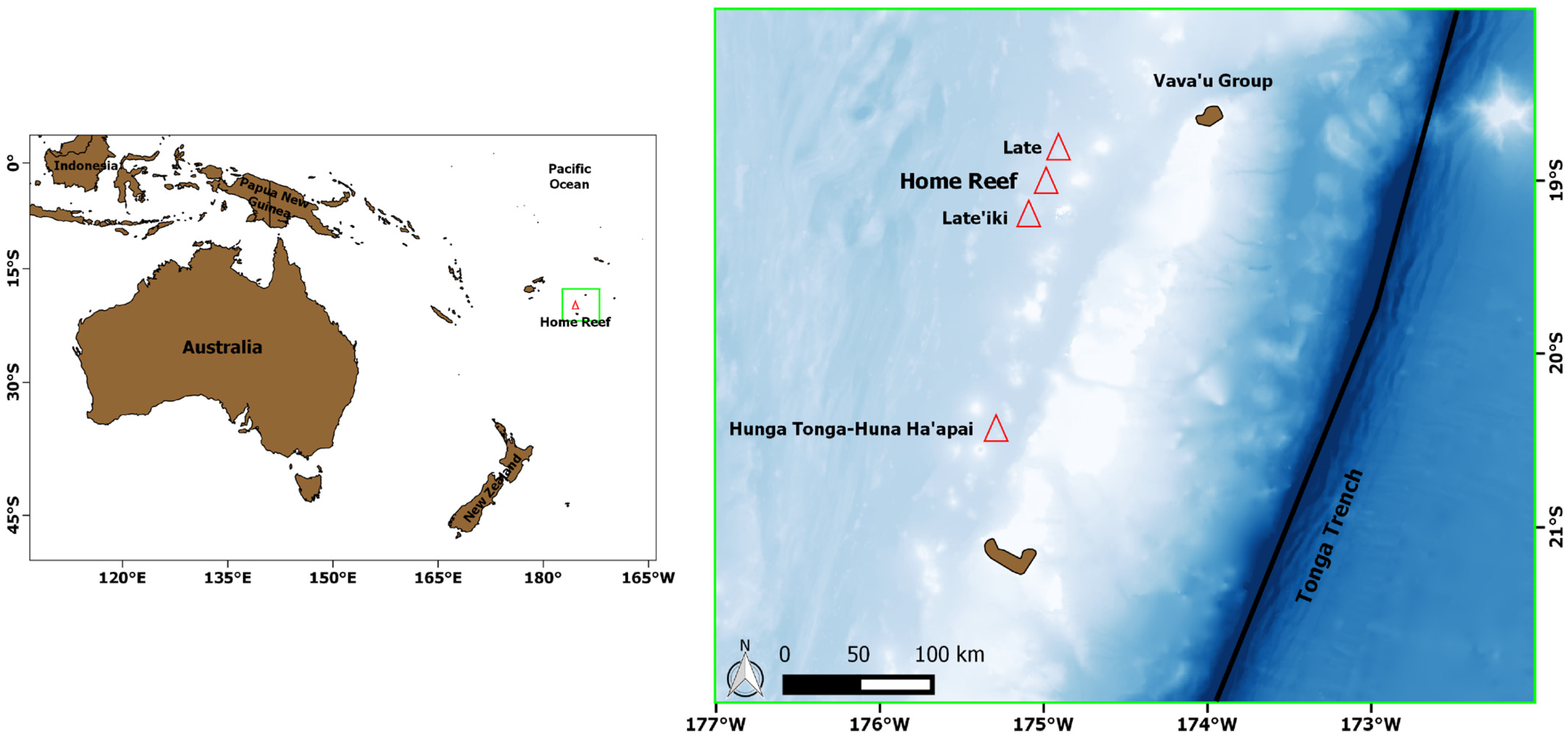
2. Test Case: Home Reef (Tonga Islands) Eruptions
3. Data and Methods
3.1. SLSTR Instrument
3.2. The Normalized Hotspot Index—NHISWIR
3.3. NHI Implementation on SLSTR SWIR Data
4. Results
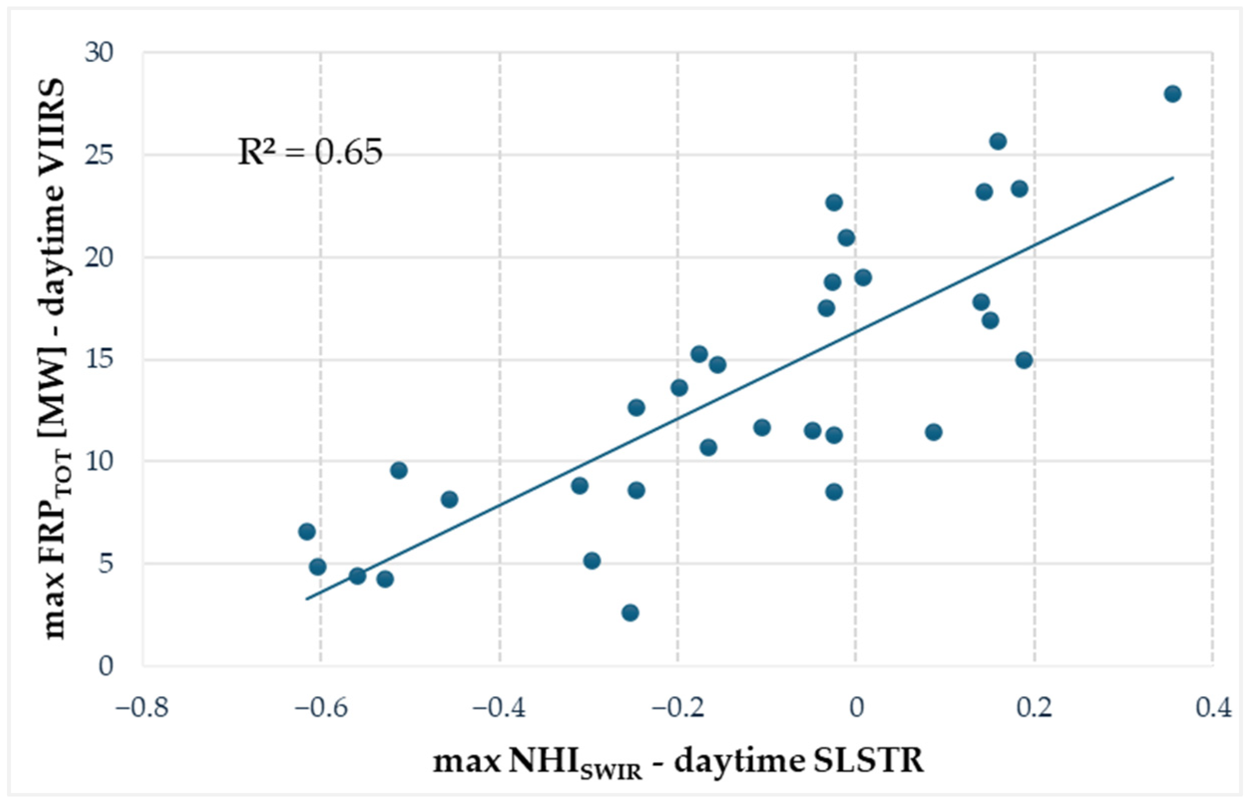
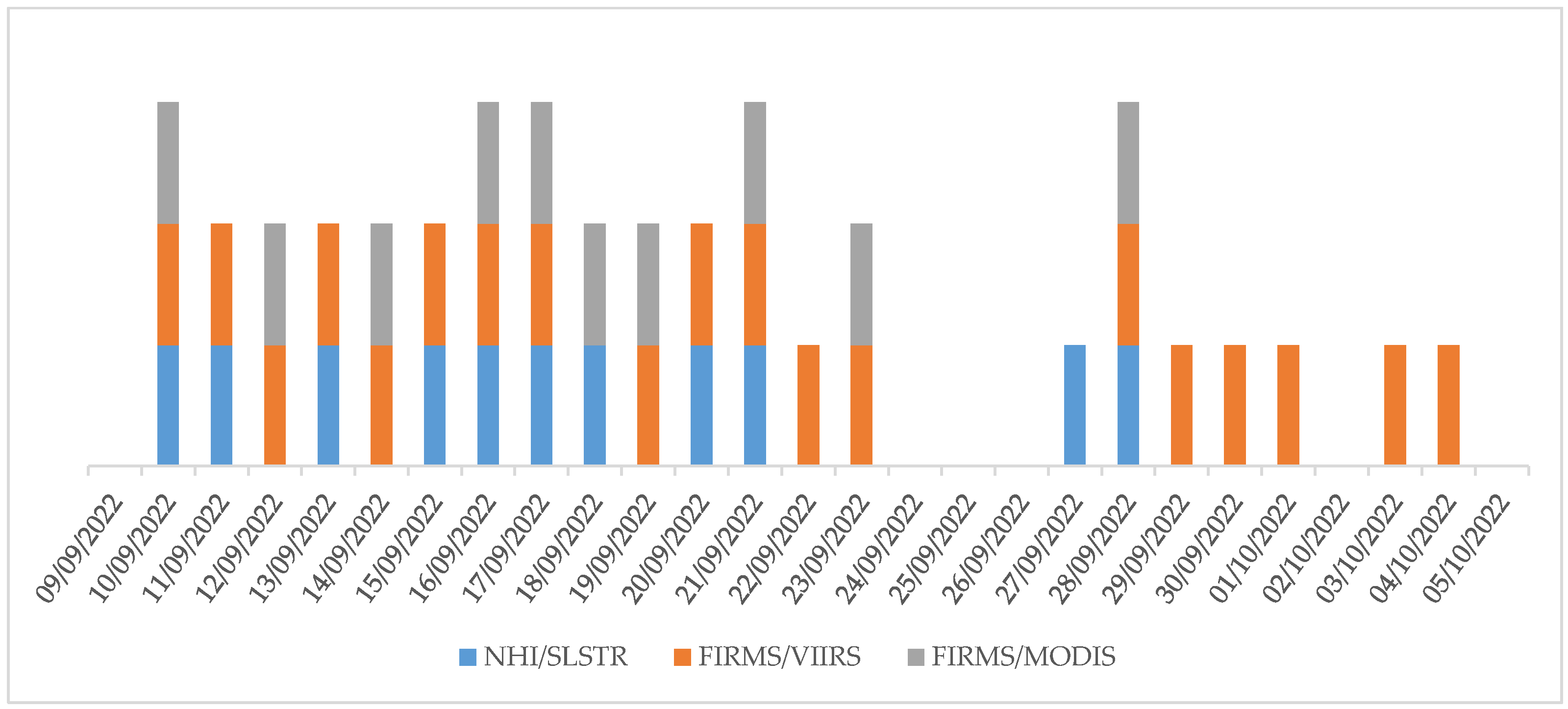
4.1. Investigating the First Home Reef Eruption Phase
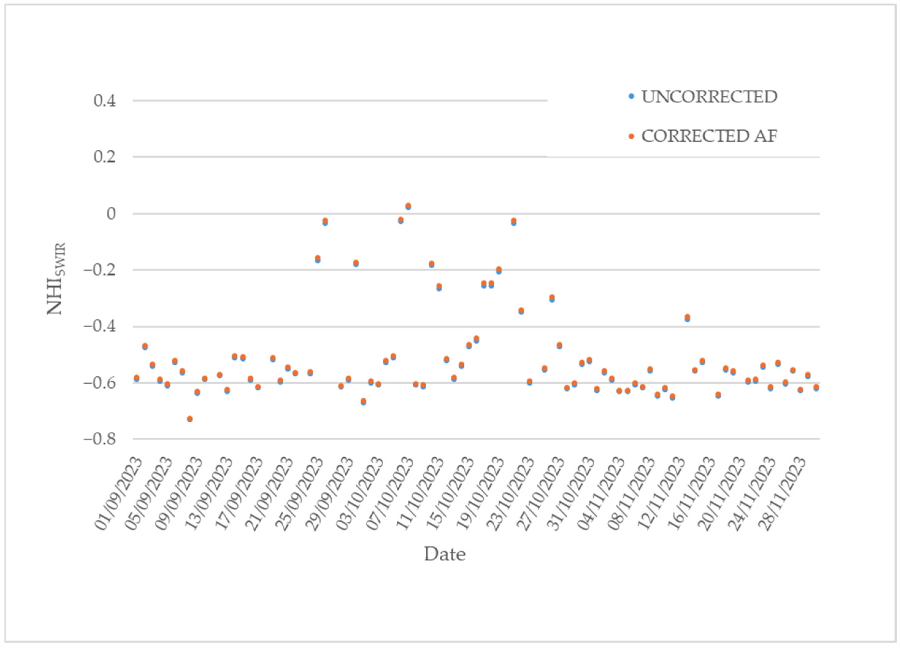
4.2. Investigating the Second Phase of the Home Reef Eruption
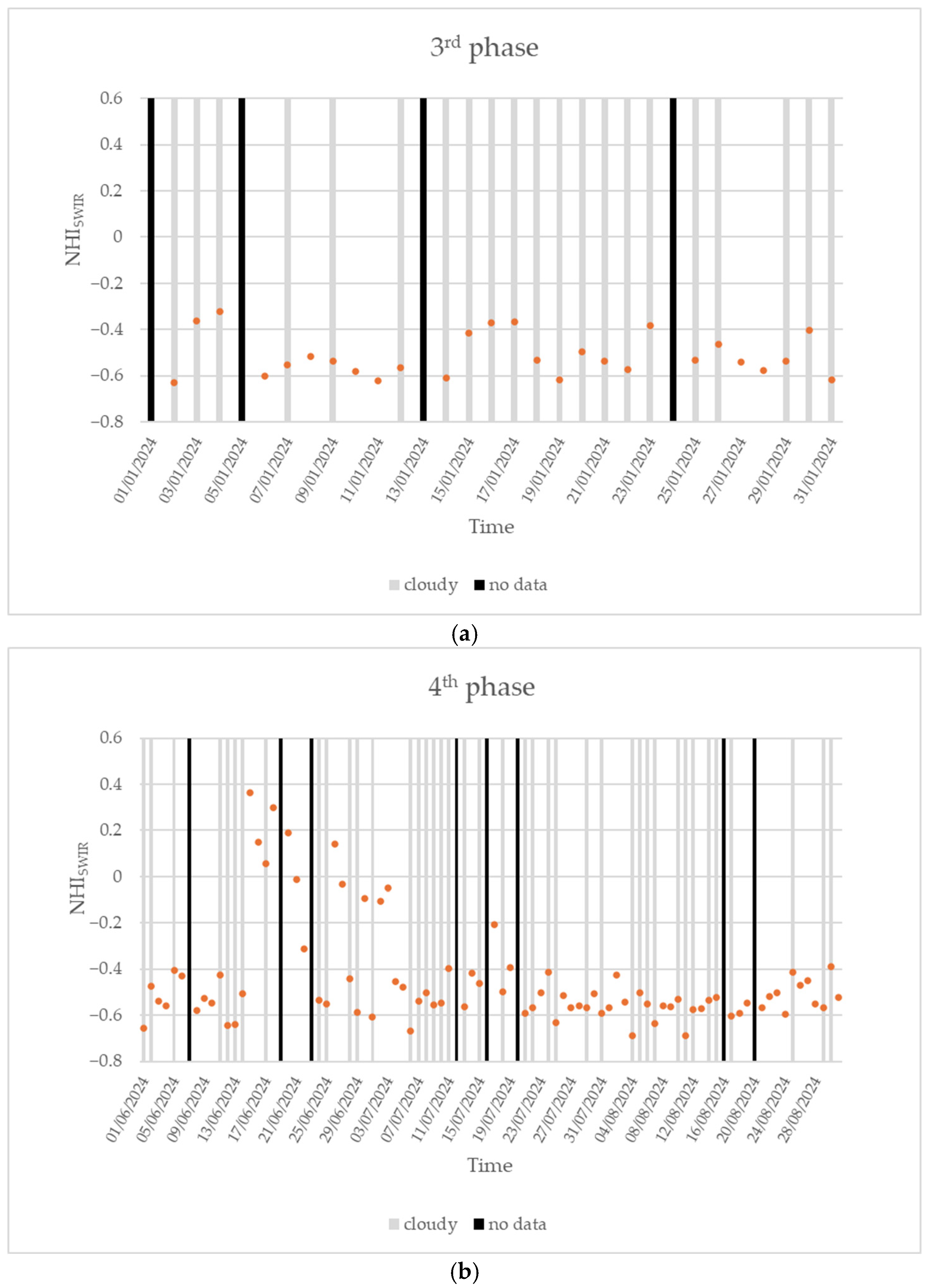
4.3. Investigating the Third and Fourth Phases of the Home Reef Eruption
5. Discussion
6. Conclusions
Author Contributions
Funding
Institutional Review Board Statement
Informed Consent Statement
Data Availability Statement
Acknowledgments
Conflicts of Interest
References
- Cottrell, E. Global Distribution of Active Volcanoes. In Volcanic Hazards, Risks and Disasters. Hazards and Disaster; Shroder, J.F., Papale, P., Eds.; Elsevier: Amsterdam, The Netherlands, 2015; pp. 1–16. [Google Scholar]
- Loughlin, S.C.; Sparks, R.S.J.; Brown, S.K.; Jenkins, S.F.; Vye-Brown, C. Global Volcanic Hazards and Risk; Cambridge University Press: Cambridge, UK, 2015. [Google Scholar]
- United States Geological Survey (USGS). Why Is It Important to Monitor Volcanoes? Available online: https://www.usgs.gov/faqs/why-it-important-monitor-volcanoes (accessed on 15 January 2025).
- Coppola, D.; Cardone, D.; Laiolo, M.; Aveni, S.; Campus, A.; Massimetti, F. Global radiant flux from active volcanoes: The 2000–2019 MIROVA database. Front. Earth Sci. 2023, 11, 1240107. [Google Scholar] [CrossRef]
- Wright, R.; Flynn, L.; Garbeil, H.; Harris, A.; Pilger, E. Automated volcanic eruption detection using MODIS. Remote Sens. Environ. 2002, 82, 135–155. [Google Scholar] [CrossRef]
- Kervyn, M.; Ernst, G.G.J.; Harris, A.J.L.; Belton, F.; Mbede, E.; Jacobs, P. Thermal remote sensing of the low-intensity carbonatite volcanism of Oldoinyo Lengai, Tanzania. Int. J. Remote Sens. 2008, 29, 6467–6499. [Google Scholar] [CrossRef]
- Steffke, A.M.; Harris, A.J. A review of algorithms for detecting volcanic hot spots in satellite infrared data. Bull. Volcanol. 2011, 73, 1109–1137. [Google Scholar] [CrossRef]
- Wooster, M.J.; Zhukov, B.; Oertel, D. Fire radiative energy for quantitative study of biomass burning: Derivation from the BIRD experimental satellite and comparison to MODIS fire products. Remote Sens. Environ. 2003, 86, 83–107. [Google Scholar] [CrossRef]
- Coppola, D.; Cigolini, C. Thermal regimes and effusive trends at Nyamuragira volcano (DRC) from MODIS infrared data. Bull. Volcanol. 2013, 75, 744. [Google Scholar] [CrossRef]
- Coppola, D.; Laiolo, M.; Cigolini, C.; Delle Donne, D.; Ripepe, M. Enhanced volcanic hot-spot detection using MODIS IR data: Results from the MIROVA system. Geol. Soc. Lond. Spec. Publ. 2015, 426, 181–205. [Google Scholar] [CrossRef]
- Campus, A.; Laiolo, M.; Massimetti, F.; Coppola, D. The transition from MODIS to VIIRS for global volcano thermal monitoring. Sensors 2022, 22, 1713. [Google Scholar] [CrossRef]
- Saunders-Shultz, P.; Lopez, T.; Dietterich, H.; Girona, T. Automatic identification and quantification of volcanic hotspots in Alaska using HotLINK: The hotspot learning and identification network. Front. Earth Sci. 2024, 12, 1345104. [Google Scholar] [CrossRef]
- Caseiro, A.; Rücker, G.; Tiemann, J.; Leimbach, D.; Lorenz, E.; Frauenberger, O.; Kaiser, J.W. Persistent hot spot detection and characterisation using SLSTR. Remote Sens. 2018, 10, 1118. [Google Scholar] [CrossRef]
- Aveni, S.; Laiolo, M.; Campus, A.; Massimetti, F.; Coppola, D. TIRVolcH, Thermal Infrared Recognition of Volcanic Hotspots. A single band TIR-based algorithm to detect low-to-high thermal anomalies in volcanic regions. Remote Sens. Environ. 2024, 315, 114388. [Google Scholar] [CrossRef]
- Fire Information for Resource Management System (FIRMS). Available online: https://firms.modaps.eosdis.nasa.gov/map/#d:24hrs;@2.1,-5.5,2.7z (accessed on 4 October 2024).
- Plank, S.; Marchese, F.; Filizzola, C.; Pergola, N.; Neri, M.; Nolde, M.; Martinis, S. The July/August 2019 lava flows at the Sciara del Fuoco, Stromboli–Analysis from multi-sensor infrared satellite imagery. Remote Sens. 2019, 11, 2879. [Google Scholar] [CrossRef]
- Plank, S.; Marchese, F.; Genzano, N.; Nolde, M.; Martinis, S. The short life of the volcanic island New Latei’iki (Tonga) analyzed by multi-sensor remote sensing data. Sci. Rep. 2020, 10, 22293. [Google Scholar] [CrossRef]
- Martha, T.R.; Roy, P.; Vinod Kumar, K. Lava flows and cinder cones at Barren Island volcano, India (2005–2017): A spatio-temporal analysis using satellite images. Bull. Volcanol. 2018, 80, 1–8. [Google Scholar] [CrossRef]
- Ganci, G.; Bilotta, G.; Zuccarello, F.; Calvari, S.; Cappello, A. A multi-sensor satellite approach to characterize the volcanic deposits emitted during Etna’s lava fountaining: The 2020–2022 study case. Remote Sens. 2023, 15, 916. [Google Scholar] [CrossRef]
- Torrisi, F.; Amato, E.; Corradino, C.; Del Negro, C. The FastVRP automatic platform for the thermal monitoring of volcanic activity using VIIRS and SLSTR sensors: FastFRP to monitor volcanic radiative power. Ann. Geophys. 2020, 65. [Google Scholar] [CrossRef]
- Wooster, M.J.; Xu, W.; Nightingale, T. Sentinel-3 SLSTR Active Fire Detection and FRP Product: Pre-Launch Algorithm Development and Performance Evaluation Using MODIS and ASTER Datasets. Remote Sens. Environ. 2012, 120, 236–254. [Google Scholar] [CrossRef]
- Caseiro, A.; Rücker, G.; Tiemann, J.; Leimbach, D.; Lorenz, E.; Frauenberger, O.; Kaiser, J.W. A methodology for gas flaring detection and characterisation using SLSTR. Remote Sens. 2018, 10, 1118. [Google Scholar] [CrossRef]
- Fisher, D.; Wooster, M.J. Multi-decade global gas flaring change inventoried using the ATSR-1, ATSR-2, AATSR and SLSTR data records. Remote Sens. Environ. 2019, 232, 111298. [Google Scholar] [CrossRef]
- Caseiro, A.; Soszyńska, A. Quantification of Gas Flaring from Satellite Imagery: A Comparison of Two Methods for SLSTR and BIROS Imagery. J. Imaging 2023, 9, 152. [Google Scholar] [CrossRef]
- Xu, W.; Wooster, M.J. Sentinel-3 SLSTR active fire (AF) detection and FRP daytime product-Algorithm description and globalintercomparison to MODIS, VIIRS and landsat AF data. Sci. Remote Sens. 2023, 7, 100087. [Google Scholar] [CrossRef]
- EUMETSAT Data Service. SLSTR Level 2 Fire Radiative Power in NRT—Sentinel-3. Available online: https://navigator.eumetsat.int/product/EO:EUM:DAT:0207 (accessed on 23 October 2023).
- ESA OPT-MPC. Sentinel-3 Product Notice—SLSTR Fire Radiative Power Products. Available online: https://sentinel.esa.int/documents/247904/4760806/S3.PN-SLSTR-FRP.03+-+i1r0+-+SLSTR+L2+FRP+%28PB+FRP_NTC.004.07.00%29.pdf (accessed on 23 October 2023).
- Di Bella, G.S.; Corradino, C.; Cariello, S.; Torrisi, F.; Del Negro, C. Advancing Volcanic Activity Monitoring: A Near-Real-Time Approach with Remote Sensing Data Fusion for Radiative Power Estimation. Remote Sens. 2024, 16, 2879. [Google Scholar] [CrossRef]
- Marchese, F.; Genzano, N.; Neri, M.; Falconieri, A.; Mazzeo, G.; Pergola, N. A Multi-Channel Algorithm for Mapping Volcanic Thermal Anomalies by Sentinel-2 MSI and Landsat-8 OLI Data. Remote Sens. 2019, 11, 2876. [Google Scholar] [CrossRef]
- Global Volcanism Program. Report on Home Reef (Tonga); Bulletin of the Global Volcanism Network, 47:11; Bennis, K.L., Venzke, E., Eds.; Smithsonian Institution: Washington, DC, USA, 2022. [Google Scholar]
- Global Volcanism Program. Report on Home Reef (Tonga); Weekly Volcanic Activity Report, 11 October-17 October 2023; Sennert, S., Ed.; Smithsonian Institution: Washington, DC, USA; US Geological Survey: Washington, DC, USA, 2023. [Google Scholar]
- Global Volcanism Program. Report on Home Reef (Tonga); Sennert, S., Ed.; Weekly Volcanic Activity Report, 1 January-7 January 2025; Smithsonian Institution: Washington, DC, USA; US Geological Survey: Washington, DC, USA, 2025. [Google Scholar]
- Genzano, N.; Pergola, N.; Marchese, F. A Google Earth Engine tool to investigate, map and watch volcanic thermal anomalies at global scale by means of mid-high spatial resolution satellite data. Remote Sens. 2020, 12, 3232. [Google Scholar] [CrossRef]
- SentiWiki. S3 SLSTR Instrument. Available online: https://sentiwiki.copernicus.eu/web/s3-slstr-instrument (accessed on 7 October 2024).
- Donlon, C.; Berruti, B.; Buongiorno, A.; Ferreira, M.-H.; Féménias, P.; Frerick, J.; Goryl, P.; Klein, U.; Laur, H.; Mavrocordatos, C.; et al. The Global Monitoring for Environment and Security (GMES) Sentinel-3 mission. Remote Sens. Environ. 2012, 120, 37–57. [Google Scholar] [CrossRef]
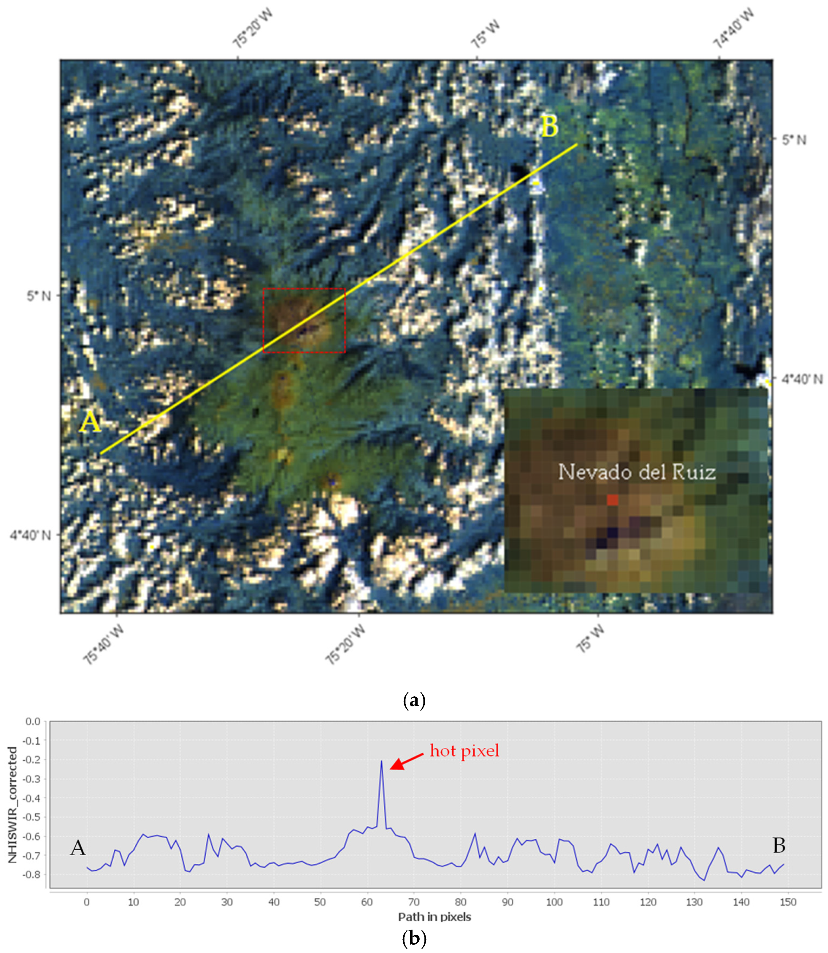
- Marchese, F.; Genzano, N. Global volcano monitoring through the Normalized Hotspot Indices (NHI) system. J. Geol. Soc. 2023, 180, jgs2022-014. [Google Scholar] [CrossRef]
- Marchese, F.; Coppola, D.; Falconieri, A.; Genzano, N.; Pergola, N. Investigating Phases of Thermal Unrest at Ambrym (Vanuatu) Volcano through the Normalized Hot Spot Indices Tool and the Integration with the MIROVA System. Remote Sens. 2022, 14, 3136. [Google Scholar] [CrossRef]
- Genzano, N.; Marchese, F.; Plank, S.; Pergola, N. Monitoring the Mauna Loa (Hawaii) eruption of November–December 2022 from space: Results from goes-r, sentinel-2 and Landsat-8/9 observations. Int. J. Appl. Earth Obs. Geoinf. 2023, 122, 103388. [Google Scholar] [CrossRef]
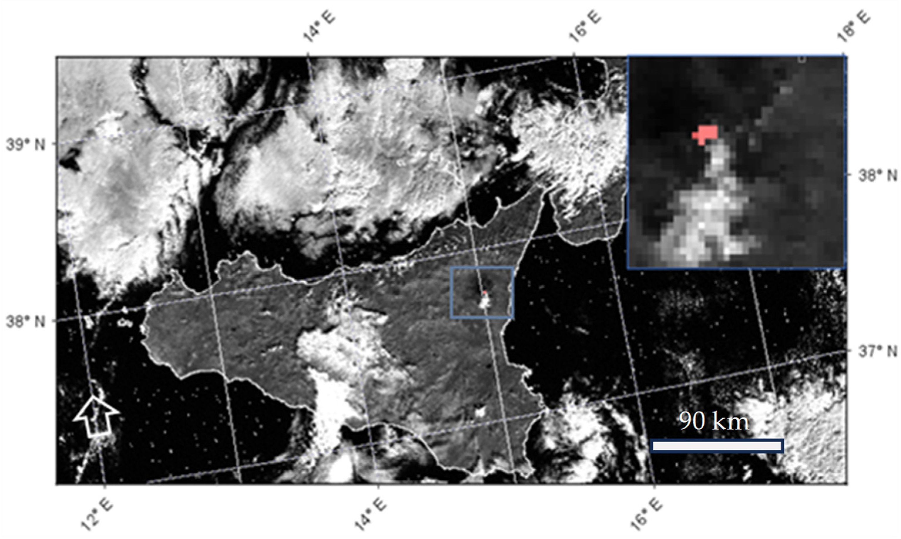
- Global Volcanism Program. Report on Nevado del Ruiz (Colombia); Weekly Volcanic Activity Report, 3 January–9 January 2024; Sennert, S., Ed.; Smithsonian Institution: Washington, DC, USA; US Geological Survey: Washington, DC, USA, 2024. [Google Scholar]
- Mantas, V.M.; Pereira, A.J.S.C.; Morais, P.V. Plumes of discolored water of volcanic origin and possible implications for algal communities. The case of the Home Reef eruption of 2006 (Tonga, Southwest Pacific Ocean). Remote Sens. Environ. 2011, 115, 1341–1352. [Google Scholar] [CrossRef]
- EUMETSAT Data Service. SLSTR Level 1B Radiances and Brightness Temperatures—Sentinel-3. Available online: https://data.eumetsat.int/data/map/EO:EUM:DAT:0411 (accessed on 26 November 2024).
- Birks, A.; Cox, C.; Smith, D.; Dawson, D. SLSTR: Algorithm Theoretical Basis Definition Document for Level 1 Observables; Science and Technology Facilities Council: Swindon, UK, 2011; 173p. [Google Scholar]
- ESA-Copernicus, SLSTR Product. Available online: https://sentiwiki.copernicus.eu/web/slstr-products (accessed on 29 November 2024).
- Bulgin, C.E.; Faulkner, A.; Merchant, C.J.; Corlett, G.K.; McCarroll, N.; Embury, O.; Polehampton, E.; McGurk, C. Improving the combined use of reflectance and thermal channels for ocean and coastal cloud detection for the Sea and Land Surface Temperature Radiometer (SLSTR). Remote Sens. Environ. 2023, 290, 113531. [Google Scholar] [CrossRef]
- Coppo, P.; Mastrandrea, C.; Stagi, M.; Calamai, L.; Barilli, M.; Nieke, J. The Sea and Land Surface Temperature Radiometer (SLSTR) Detection Assembly design and performance. In Proceedings of the Sensors, Systems, and Next-Generation Satellites XVII, Dresden, Germany, 23–26 September 2013; Meynart, R., Neeck, S.P., Shimoda, H., Eds.; SPIE: Bellingham, WA, USA, 2013; Volume 8889, p. 888914. [Google Scholar] [CrossRef]
- ESA-EUMETSAT. S3.PN-SLSTR-L1.11, Sentinel-3 Product Notice—SLSTR. 2024. Available online: https://sentinels.copernicus.eu/documents/d/sentinel/s3-pn-slstr-l1-11-i1r0-slstr-l1-pb-sl__l1_-004-07-00 (accessed on 15 January 2025).
- SentWiki Copernicus, Sentinel-3 SLSTR VIS and SWIR Channel Vicarious Calibration Adjustments. Available online: https://sentiwiki.copernicus.eu/__attachments/1672112/S3MPC.RAL.TN.020%20-%20Sentinel-3%20SLSTR%20VIS%20and%20SWIR%20Channel%20Vicarious%20Calibration%20Adjustment%202021%20-%203.0.pdf?inst-v=a30e0cf1-d720-476f-a010-d662495e96fa (accessed on 10 October 2024).
- Copernicus Sentinel-3 SLSTR Land User Handbook. Available online: https://sentinel.esa.int/documents/247904/4598082/Sentinel-3-SLSTR-Land-Handbook.pdf (accessed on 4 December 2024).
- Plank, S.; Ciancia, E.; Genzano, N.; Falconieri, A.; Martinis, S.; Taubenböck, H.; Pergola, N.; Marchese, F. The evolution of the 2022–2024 eruption at Home Reef (Tonga) analyzed from space shows vent migration due to erosion. Sci. Rep. 2025; under review. [Google Scholar]
- Genzano, N.; Marchese, F.; Neri, M.; Pergola, N.; Tramutoli, V. Implementation of robust satellite techniques for volcanoes on ASTER data under the Google Earth engine platform. Appl. Sci. 2021, 11, 4201. [Google Scholar] [CrossRef]
- EUMETSAT Data Service. SLSTR Level 2 Fire Radiative Power—Sentinel 3. Available online: https://data.eumetsat.int/data/map/EO:EUM:DAT:0417 (accessed on 26 November 2024).
- Sentinel-3 SLSTR Level 2 Active Fire Detection and FRP Product Algorithm. Available online: https://sentiwiki.copernicus.eu/__attachments/1672112/S3-L2-SD-03-T04-KCL-ATBD_FIREPRODUCT%20-%20Sentinel-3%20SLSTR%20Level%202%20Active%20Fire%20Detection%20and%20FRP2022%20-%205.1.pdf?inst-v=d105f701-8f35-4a57-9bd3-983ac5f50bca (accessed on 15 January 2025).
- EUMETSAT, Copernicus Sentinel-3 SLSTR Near Real Time Fire Radiative Power. Available online: https://user.eumetsat.int/resources/user-guides/copernicus-sentinel-3-slstr-near-real-time-fire-radiative-power (accessed on 29 November 2024).
- EUMETSAT. Product Data Format Specification—SLSTR Level 1 Products. Available online: https://user.eumetsat.int/s3/eup-strapi-media/S3_IPF_PDS_005_1_i2r9_Product_Data_Format_Specification_SLSTR_Level_1_c91250e482.pdf (accessed on 29 November 2024).


| Band | Central Wavelength (nm) | Spatial Resolution (m) |
|---|---|---|
| S1 | 554.27 | 500 |
| S2 | 659.47 | 500 |
| S3 | 868 | 500 |
| S4 | 1374.80 | 500 |
| S5 | 1613.40 | 500 |
| S6 | 2255.60 | 500 |
| S7 | 3742 | 1000 |
| S8 | 10854 | 1000 |
| S9 | 12,022.50 | 1000 |
| F1 | 3742 | 1000 |
| F2 | 10,854 | 1000 |
Disclaimer/Publisher’s Note: The statements, opinions and data contained in all publications are solely those of the individual author(s) and contributor(s) and not of MDPI and/or the editor(s). MDPI and/or the editor(s) disclaim responsibility for any injury to people or property resulting from any ideas, methods, instructions or products referred to in the content. |
© 2025 by the authors. Licensee MDPI, Basel, Switzerland. This article is an open access article distributed under the terms and conditions of the Creative Commons Attribution (CC BY) license (https://creativecommons.org/licenses/by/4.0/).
Share and Cite
Falconieri, A.; Marchese, F.; Ciancia, E.; Genzano, N.; Mazzeo, G.; Pietrapertosa, C.; Pergola, N.; Plank, S.; Filizzola, C. Exploring the Potential of a Normalized Hotspot Index in Supporting the Monitoring of Active Volcanoes Through Sea and Land Surface Temperature Radiometer Shortwave Infrared (SLSTR SWIR) Data. Sensors 2025, 25, 1658. https://doi.org/10.3390/s25061658
Falconieri A, Marchese F, Ciancia E, Genzano N, Mazzeo G, Pietrapertosa C, Pergola N, Plank S, Filizzola C. Exploring the Potential of a Normalized Hotspot Index in Supporting the Monitoring of Active Volcanoes Through Sea and Land Surface Temperature Radiometer Shortwave Infrared (SLSTR SWIR) Data. Sensors. 2025; 25(6):1658. https://doi.org/10.3390/s25061658
Chicago/Turabian StyleFalconieri, Alfredo, Francesco Marchese, Emanuele Ciancia, Nicola Genzano, Giuseppe Mazzeo, Carla Pietrapertosa, Nicola Pergola, Simon Plank, and Carolina Filizzola. 2025. "Exploring the Potential of a Normalized Hotspot Index in Supporting the Monitoring of Active Volcanoes Through Sea and Land Surface Temperature Radiometer Shortwave Infrared (SLSTR SWIR) Data" Sensors 25, no. 6: 1658. https://doi.org/10.3390/s25061658
APA StyleFalconieri, A., Marchese, F., Ciancia, E., Genzano, N., Mazzeo, G., Pietrapertosa, C., Pergola, N., Plank, S., & Filizzola, C. (2025). Exploring the Potential of a Normalized Hotspot Index in Supporting the Monitoring of Active Volcanoes Through Sea and Land Surface Temperature Radiometer Shortwave Infrared (SLSTR SWIR) Data. Sensors, 25(6), 1658. https://doi.org/10.3390/s25061658