

Quantifying Root Cohesion Spatial Heterogeneity Using Remote Sensing for Improved Landslide Susceptibility Modeling: A Case Study of Caijiachuan Landslides


Abstract
1. Introduction
2. Study Area and Data Sources
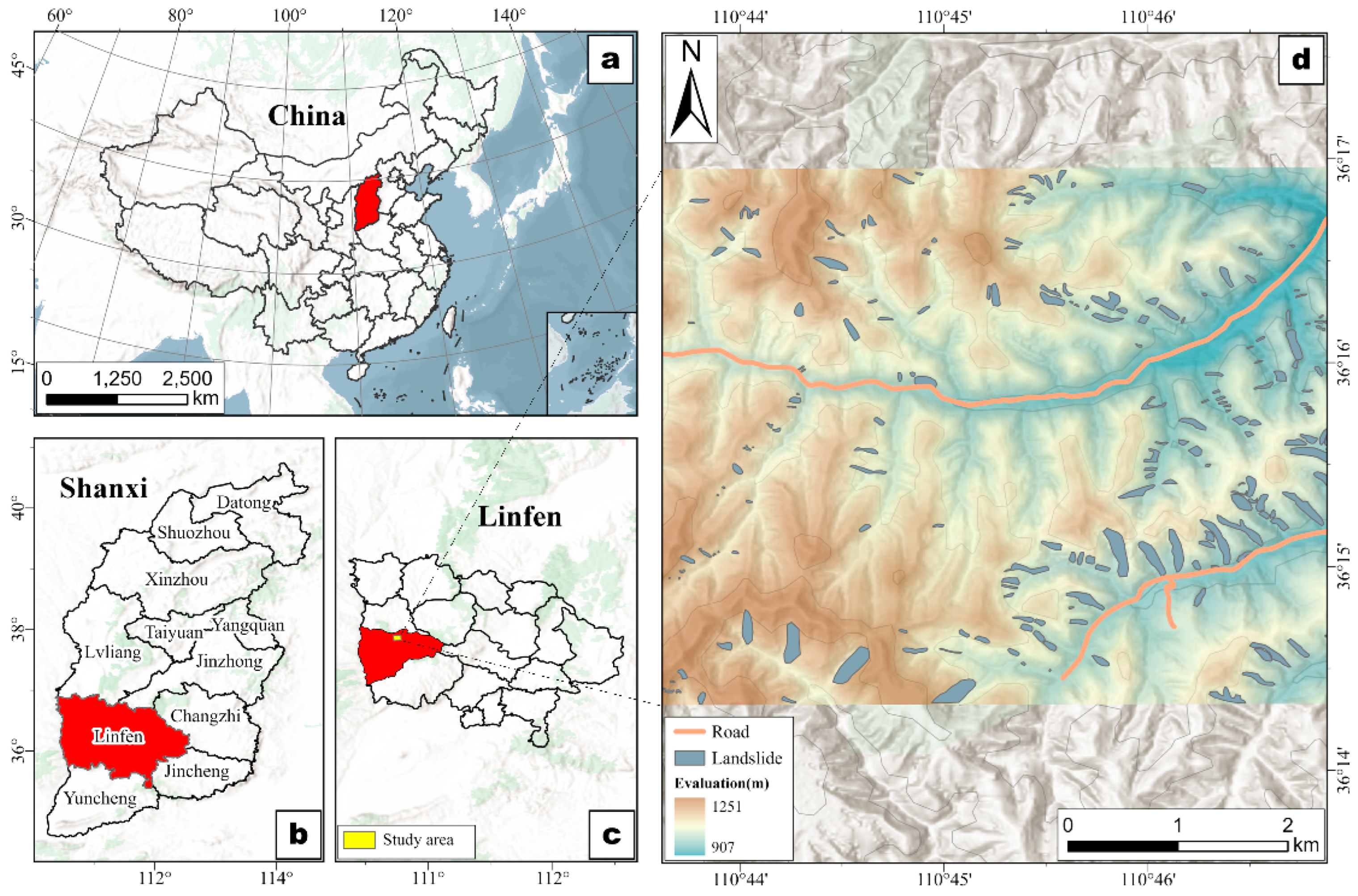
2.1. Study Area
2.2. Data Sources Used in This Study
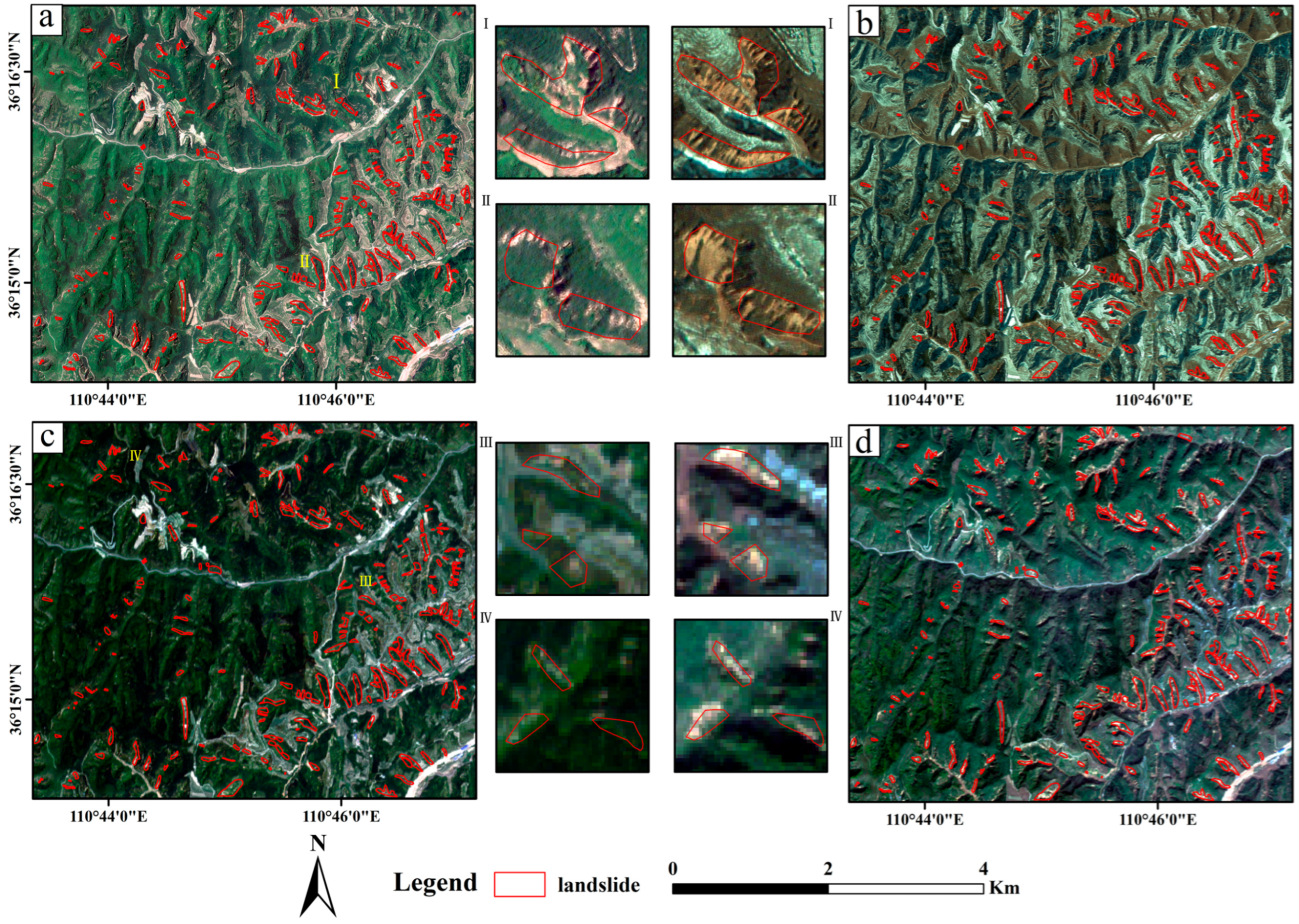
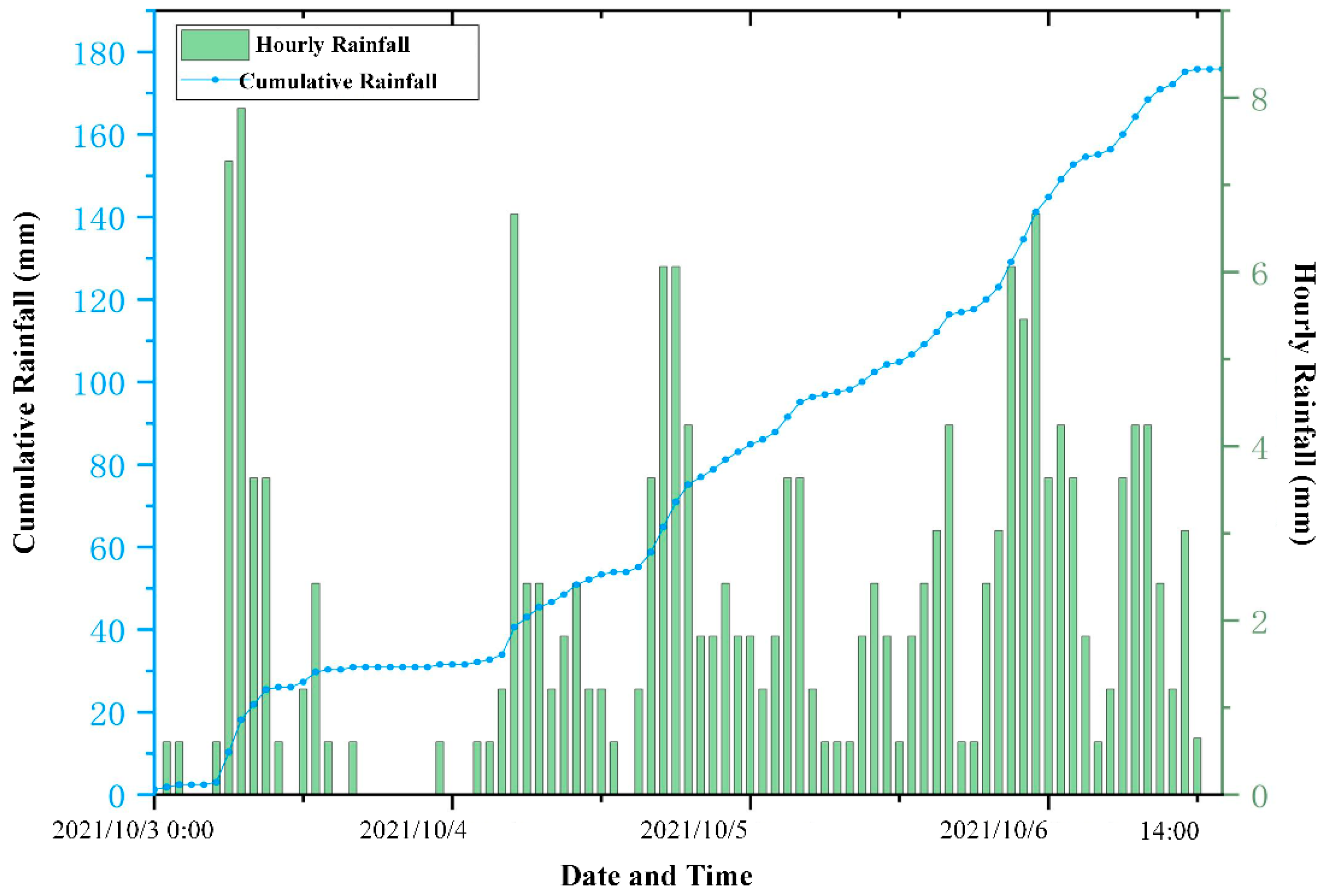
2.3. Description and Analysis of Landslide Inventory
3. Methodology
3.1. The Infinite Slope Stability Model
3.2. The Infiltration Model
3.3. The Root Cohesion Inversion Model
3.4. The Infinite Slope Stability Model Considering the Influence of Land Use and Rainfall
4. Experimental Results
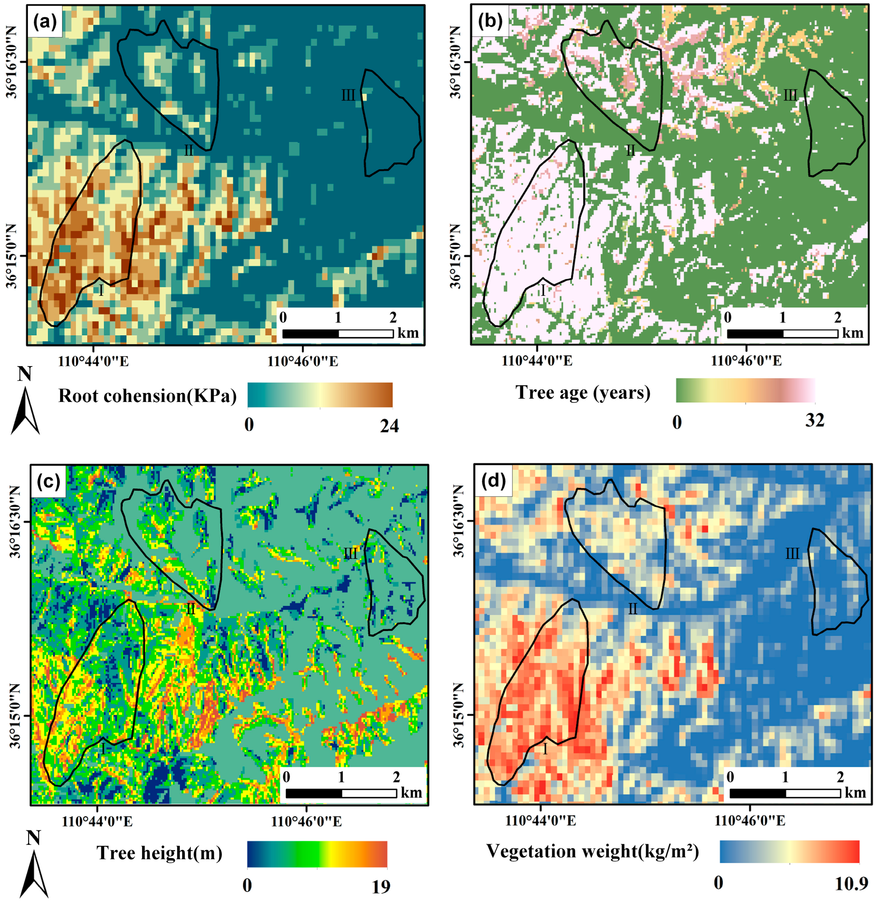
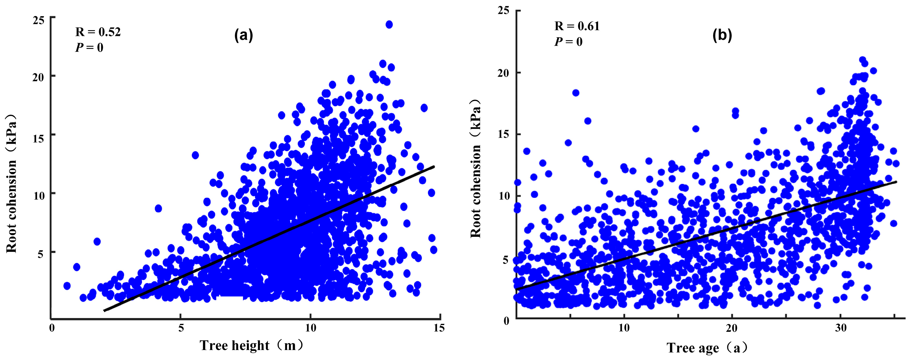
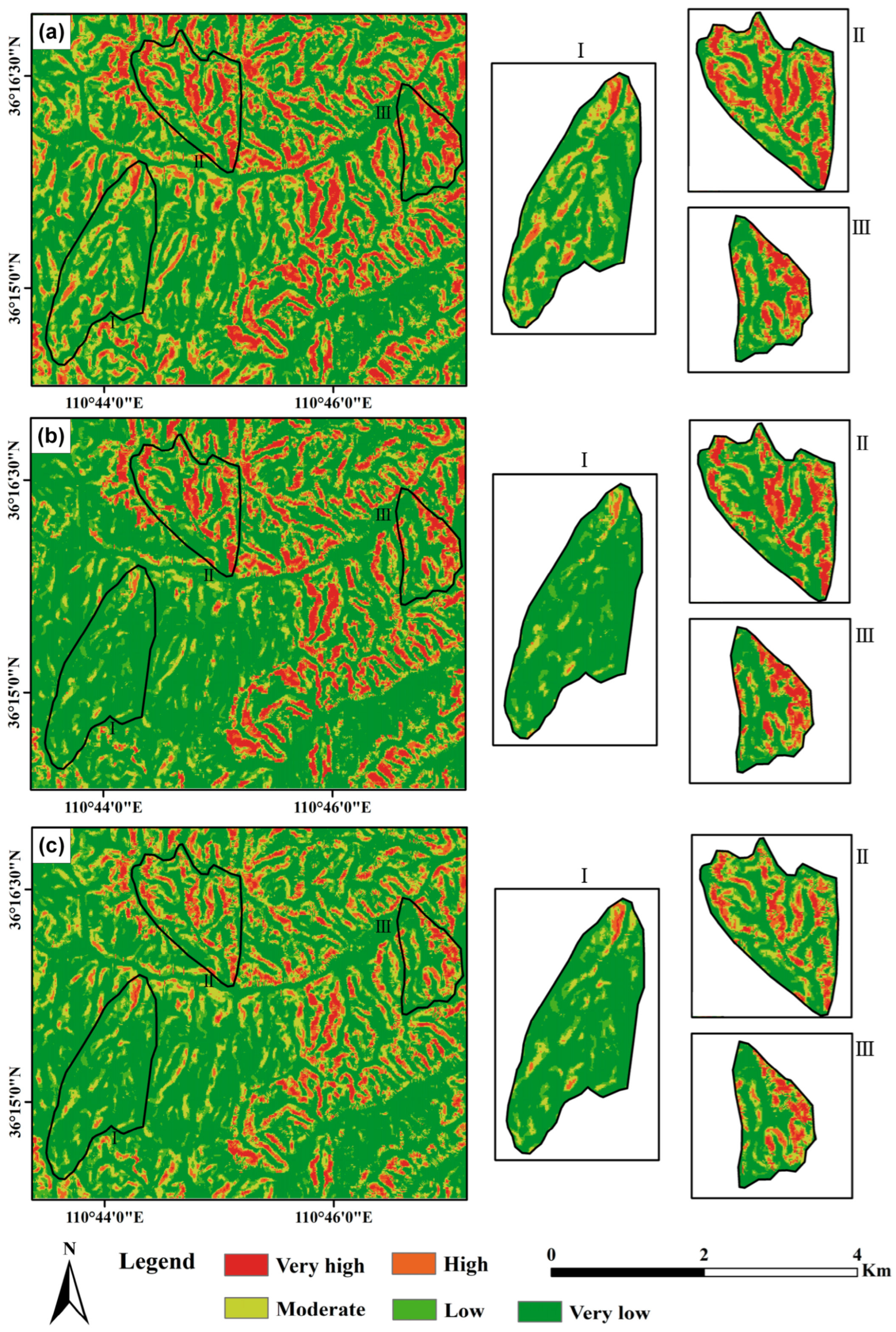
4.1. Analysis of Root Cohesion Inversion Results
4.2. Validation of Root Cohesion Inversion Accounting for Spatial Heterogeneity
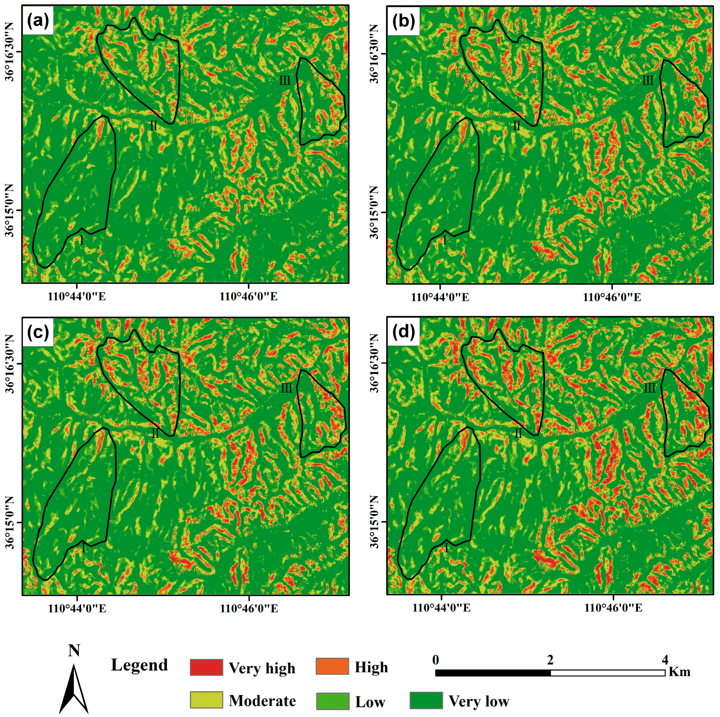
4.3. Dynamics of Landslide Susceptibility Across Different Land Uses During a Rainfall Event
4.4. Impact of Root Cohesion on Rainfall Thresholds for Landslides
5. Discussion
5.1. Uncertainties in Satellite-Derived Root Cohesion Models for Landslide Susceptibility Assessment
5.2. Complex Role of Root Cohesion in Slope Stability Under Various Conditions
6. Conclusions
- (1)
- Root cohesion spatial heterogeneity is critical: Inversion of root cohesion using satellite-derived tree height and biomass revealed significant spatial variability. Secondary forests exhibited substantially higher cohesion values than farmland, attributable to greater tree height and stand age. This underscores the limitation of uniform root parameter assumptions.
- (2)
- Spatially explicit cohesion mapping enhances validation: Using high-resolution Gaofen imagery to construct a validated landslide inventory, the model incorporating heterogeneous root cohesion achieved superior prediction accuracy. This significantly outperformed models assuming uniform root cohesion or neglecting root reinforcement, confirming the value of remote sensing-based inversion for susceptibility assessment.
- (3)
- Land use governs dynamic susceptibility: Time-resolved analysis during an extreme rainfall event (>250 mm/day) identified farmland as the most vulnerable land use, with susceptibility escalating markedly during peak rainfall. Secondary forests exhibited greater resilience, attributed to their well-developed root systems.
- (4)
- Integrated approach enables scalable assessment: Combining satellite data with physics-based modeling provides a scalable and transferable methodology for landslide susceptibility mapping, particularly valuable in data-scarce or inaccessible regions.
Author Contributions
Funding
Institutional Review Board Statement
Informed Consent Statement
Data Availability Statement
Conflicts of Interest
References
- Cummins, P.R. Irrigation and the Palu Landslides. Nat. Geosci. 2019, 12, 881–882. [Google Scholar] [CrossRef]
- Depicker, A.; Jacobs, L.; Mboga, N.; Smets, B.; Van Rompaey, A.; Lennert, M.; Wolff, E.; Kervyn, F.; Michellier, C.; Dewitte, O. Historical Dynamics of Landslide Risk from Population and Forest-Cover Changes in the Kivu Rift. Nat. Sustain. 2021, 4, 965–974. [Google Scholar] [CrossRef]
- Nguyen, H.T.; Wiatr, T.; Fernández-Steeger, T.M.; Reicherter, K.; Rodrigues, D.M.M.; Azzam, R. Landslide Hazard and Cascading Effects Following the Extreme Rainfall Event on Madeira Island (February 2010). Nat. Hazards 2013, 65, 635–652. [Google Scholar] [CrossRef]
- Araújo, J.R.; Ramos, A.M.; Soares, P.M.M.; Melo, R.; Oliveira, S.C.; Trigo, R.M. Impact of Extreme Rainfall Events on Landslide Activity in Portugal under Climate Change Scenarios. Landslides 2022, 19, 2279–2293. [Google Scholar] [CrossRef]
- Bird, L.J.; Bodeker, G.E.; Clem, K.R. Sensitivity of Extreme Precipitation to Climate Change Inferred Using Artificial Intelligence Shows High Spatial Variability. Nat. Commun. Earth Environ. 2023, 4, 469. [Google Scholar] [CrossRef]
- Mathews, N.W.; Leshchinsky, B.A.; Mirus, B.B.; Olsen, M.J.; Booth, A.M. RegionGrow3D: A Deterministic Analysis for Characterizing Discrete Three-dimensional Landslide Source Areas on a Regional Scale. J. Geophys. Res. Earth Surf. 2024, 129, e2024JF007815. [Google Scholar] [CrossRef]
- Lin, Q.; Steger, S.; Pittore, M.; Zhang, J.; Wang, L.; Jiang, T.; Wang, Y. Evaluation of Potential Changes in Landslide Susceptibility and Landslide Occurrence Frequency in China under Climate Change. Sci. Total Environ. 2022, 850, 158049. [Google Scholar] [CrossRef]
- Sameen, M.I.; Pradhan, B.; Lee, S. Application of Convolutional Neural Networks Featuring Bayesian Optimization for Landslide Susceptibility Assessment. Catena 2020, 186, 104249. [Google Scholar] [CrossRef]
- Chen, W.; Pourghasemi, H.R.; Panahi, M.; Kornejady, A.; Wang, J.; Xie, X.; Cao, S. Spatial Prediction of Landslide Susceptibility Using an Adaptive Neuro-Fuzzy Inference System Combined with Frequency Ratio, Generalized Additive Model, and Support Vector Machine Techniques. Geomorphology 2017, 297, 69–85. [Google Scholar] [CrossRef]
- Du, J.; Glade, T.; Woldai, T.; Chai, B.; Zeng, B. Landslide Susceptibility Assessment Based on an Incomplete Landslide Inventory in the Jilong Valley, Tibet, Chinese Himalayas. Eng. Geol. 2020, 270, 105572. [Google Scholar] [CrossRef]
- Alvioli, M.; Loche, M.; Jacobs, L.; Grohmann, C.H.; Abraham, M.T.; Gupta, K.; Satyam, N.; Scaringi, G.; Bornaetxea, T.; Rossi, M. A Benchmark Dataset and Workflow for Landslide Susceptibility Zonation. Earth-Sci. Rev. 2024, 258, 104927. [Google Scholar] [CrossRef]
- Guzzetti, F.; Mondini, A.C.; Cardinali, M.; Fiorucci, F.; Santangelo, M.; Chang, K.-T. Landslide Inventory Maps: New Tools for an Old Problem. Earth-Sci. Rev. 2012, 112, 42–66. [Google Scholar] [CrossRef]
- Zhou, C.; Gan, L.; Cao, Y.; Wang, Y.; Segoni, S.; Shi, X.; Motagh, M.; Singhc, R.P. Landslide Susceptibility Assessment of the Wanzhou District: Merging Landslide Susceptibility Modelling (LSM) with InSAR-Derived Ground Deformation Map. Int. J. Appl. Earth Obs. Geoinf. 2025, 136, 104365. [Google Scholar] [CrossRef]
- Sestras, P.; Badea, G.; Badea, A.C.; Salagean, T.; Oniga, V.-E.; Roșca, S.; Bilașco, Ș.; Bruma, S.; Spalević, V.; Kader, S. A Novel Method for Landslide Deformation Monitoring by Fusing UAV Photogrammetry and LiDAR Data Based on Each Sensor’s Mapping Advantage in Regards to Terrain Feature. Eng. Geol. 2025, 346, 107890. [Google Scholar] [CrossRef]
- Görüm, T. Landslide Recognition and Mapping in a Mixed Forest Environment from Airborne LiDAR Data. Eng. Geol. 2019, 258, 105155. [Google Scholar] [CrossRef]
- Jones, N.; Strozzi, T.; Rabatel, A.; Ducasse, E.; Mouginot, J. Surface Instability Mapping in Alpine Paraglacial Environments Using Sentinel-1 DInSAR Techniques. IEEE J. Sel. Top. Appl. Earth Obs. Remote Sens. 2023, 16, 19–37. [Google Scholar] [CrossRef]
- Karagianni, A.; Lazos, I.; Chatzipetros, A. Remote Sensing Techniques in Disaster Management: Amynteon Mine Landslides, Greece. In Proceedings of the GeoInformation for Disaster Management Conference, Istanbul, Turkey, 18–21 March 2018; Springer: Cham, Switzerland, 2018; pp. 209–235. [Google Scholar]
- Sbihi, A.; Mastere, M.; Benzougagh, B.; Spalevic, V.; Sestras, P.; Radovic, M.; Marković, S.B.; Jaufer, L.; Kader, S. Assessing Landslide Susceptibility in Northern Morocco: A Geostatistical Mapping Approach in Al Hoceima-Ajdir. J. Afr. Earth Sci. 2024, 218, 105361. [Google Scholar] [CrossRef]
- Bammou, Y.; Benzougagh, B.; Igmoullan, B.; Kader, S.; Ouallali, A.; Spalevic, V.; Sestras, P.; Kuriqi, A. Spatial Mapping for Multi-Hazard Land Management in Sparsely Vegetated Watersheds Using Machine Learning Algorithms. Environ. Earth Sci. 2024, 83, 447. [Google Scholar] [CrossRef]
- Chen, S.; Wu, L.; Miao, Z. Regional Seismic Landslide Susceptibility Assessment Considering the Rock Mass Strength Heterogeneity. Geomat. Nat. Hazards Risk 2023, 14, 1–27. [Google Scholar] [CrossRef]
- Medina, V.; Hürlimann, M.; Guo, Z.; Lloret, A.; Vaunat, J. Fast Physically-Based Model for Rainfall-Induced Landslide Susceptibility Assessment at Regional Scale. Catena 2021, 201, 105213. [Google Scholar] [CrossRef]
- Dikshit, A.; Satyam, N.; Pradhan, B. Estimation of Rainfall-Induced Landslides Using the TRIGRS Model. Earth Syst. Environ. 2019, 3, 575–584. [Google Scholar] [CrossRef]
- Dietrich, W.E.; Bellugi, D.; Real de Asua, R. Validation of the Shallow Landslide Model, SHALSTAB, for Forest Management. Land Use Watersheds Hum. Influ. Hydrol. Geomorphol. Urban For. Areas 2001, 2, 195–227. [Google Scholar]
- Nery, T.D.; Vieira, B.C. Susceptibility to Shallow Landslides in a Drainage Basin in the Serra Do Mar, São Paulo, Brazil, Predicted Using the SINMAP Mathematical Model. Bull. Eng. Geol. Environ. 2015, 74, 369–378. [Google Scholar] [CrossRef]
- Cascini, L. Applicability of Landslide Susceptibility and Hazard Zoning at Different Scales. Eng. Geol. 2008, 102, 164–177. [Google Scholar] [CrossRef]
- Montgomery, D.R.; Dietrich, W.E. A Physically Based Model for the Topographic Control on Shallow Landsliding. Water Resour. Res. 1994, 30, 1153–1171. [Google Scholar] [CrossRef]
- Pack, R.T.; Tarboton, D.G.; Goodwin, C.N. The SINMAP Approach to Terrain Stability Mapping. In Proceedings of the 8th Congress of the International Association of Engineering Geology, Vancouver, BC, Canada, 21–25 September 1998. [Google Scholar]
- do Pinho, T.M.; Augusto Filho, O. Landslide Susceptibility Mapping Using the Infinite Slope, SHALSTAB, SINMAP, and TRIGRS Models in Serra Do Mar, Brazil. J. Mt. Sci. 2022, 19, 1018–1036. [Google Scholar] [CrossRef]
- Ma, S.; Shao, X.; Xu, C.; He, X.; Zhang, P. MAT. TRIGRS (V1. 0): A New Open-Source Tool for Predicting Spatiotemporal Distribution of Rainfall-Induced Landslides. Nat. Hazards Res. 2021, 1, 161–170. [Google Scholar] [CrossRef]
- Nguyen, T.S.; Likitlersuang, S.; Jotisankasa, A. Influence of the Spatial Variability of the Root Cohesion on a Slope-Scale Stability Model: A Case Study of Residual Soil Slope in Thailand. Bull. Eng. Geol. Environ. 2019, 78, 3337–3351. [Google Scholar] [CrossRef]
- Sakals, M.E.; Sidle, R.C. A Spatial and Temporal Model of Root Cohesion in Forest Soils. Can. J. For. Res. 2004, 34, 950–958. [Google Scholar] [CrossRef]
- Masi, E.B.; Tofani, V.; Rossi, G.; Cuomo, S.; Wu, W.; Salciarini, D.; Caporali, E.; Catani, F. Effects of Roots Cohesion on Regional Distributed Slope Stability Modelling. Catena 2023, 222, 106853. [Google Scholar] [CrossRef]
- Murgia, I.; Giadrossich, F.; Mao, Z.; Cohen, D.; Capra, G.F.; Schwarz, M. Modeling Shallow Landslides and Root Reinforcement: A Review. Ecol. Eng. 2022, 181, 106671. [Google Scholar] [CrossRef]
- Wu, T.H.; McKinnell III, W.P.; Swanston, D.N. Strength of Tree Roots and Landslides on Prince of Wales Island, Alaska. Can. Geotech. J. 1979, 16, 19–33. [Google Scholar] [CrossRef]
- Evans, J.R.; Imaizumi, F.; Ohsaka, O.; Ogawa, S. Relationship between Tree Height and Landslide Characteristics Obtained by GIS Assessment. Earth Surf. Process. Landforms 2020, 45, 3280–3292. [Google Scholar] [CrossRef]
- Gong, Q.; Wang, J.; Zhou, P.; Guo, M. A Regional Landslide Stability Analysis Method under the Combined Impact of Rainfall and Vegetation Roots in South China. Adv. Civ. Eng. 2021, 2021, 5512281. [Google Scholar] [CrossRef]
- Mohsen, E.-T.; Behzad, A.A. A Modeling Platform for Landslide Stability: A Hydrological Approach. Water 2019, 11, 2146. [Google Scholar] [CrossRef]
- Xue, Y.; Zhang, X.; Li, S.; Qiu, D.; Su, M.; Xu, Z.; Zhou, B.; Xia, T. Sensitivity Analysis of Loess Stability to Physical and Mechanical Properties: Assessment Model. Int. J. Geomech. 2019, 19, 6019012. [Google Scholar] [CrossRef]
- Zhai, B.; Sun, M.; Shen, X.; Zhu, Y.; Li, G.; Du, S. Effects of Stand Density on Growth, Soil Water Content and Nutrients in Black Locust Plantations in the Semiarid Loess Hilly Region. Sustainability 2024, 16, 376. [Google Scholar] [CrossRef]
- Hu, Y.; Sun, R.; He, M.; Zhao, J.; Li, Y.; Huang, S.; Zhang, J. Estimating Spatiotemporal Dynamics of Carbon Storage in Roinia pseudoacacia Plantations in the Caijiachuan Watershed Using Sample Plots and Uncrewed Aerial Vehicle-Borne Laser Scanning Data. Remote Sens. 2025, 17, 1365. [Google Scholar] [CrossRef]
- Chowdhury, R.; Bhattacharya, G.; Metya, S. Geotechnical Slope Analysis; CRC Press: Boca Raton, FL, USA, 2023; ISBN 0203386272. [Google Scholar]
- Naidu, S.; Sajinkumar, K.S.; Oommen, T.; Anuja, V.J.; Samuel, R.A.; Muraleedharan, C. Early Warning System for Shallow Landslides Using Rainfall Threshold and Slope Stability Analysis. Geosci. Front. 2018, 9, 1871–1882. [Google Scholar] [CrossRef]
- Iverson, R.M. Landslide Triggering by Rain Infiltration. Water Resour. Res. 2000, 36, 1897–1910. [Google Scholar] [CrossRef]
- Baum, R.L.; Godt, J.W. Early Warning of Rainfall-Induced Shallow Landslides and Debris Flows in the USA. Landslides 2010, 7, 259–272. [Google Scholar] [CrossRef]
- Baum, R.L.; Godt, J.W.; Savage, W.Z. Estimating the Timing and Location of Shallow Rainfall-induced Landslides Using a Model for Transient, Unsaturated Infiltration. J. Geophys. Res. Earth Surf. 2010, 115, F03013. [Google Scholar] [CrossRef]
- Hwang, T.; Band, L.E.; Hales, T.C.; Miniat, C.F.; Vose, J.M.; Bolstad, P.V.; Miles, B.; Price, K. Simulating Vegetation Controls on Hurricane-induced Shallow Landslides with a Distributed Ecohydrological Model. J. Geophys. Res. Biogeosci. 2015, 120, 361–378. [Google Scholar] [CrossRef]
- Mokany, K.; Raison, R.J.; Prokushkin, A.S. Critical Analysis of Root: Shoot Ratios in Terrestrial Biomes. Glob. Change Biol. 2006, 12, 84–96. [Google Scholar] [CrossRef]
- Bato, V.A. Modelling Soil Erosion and Runoff for a Super Typhoon Event Using PCRaster. J. Maps 2020, 16, 879–889. [Google Scholar] [CrossRef]
- Sabouri, M. An Investigation on Perpetual Asphalt Pavements in Minnesota. Int. J. Pavement Res. Technol. 2020, 13, 247–254. [Google Scholar] [CrossRef]
- Mao, Z.; Wang, Y.; Jourdan, C.; Cécillon, L.; Nespoulous, J.; Rey, H.; Saint-André, L.; Stokes, A. Characterizing Above-and Belowground Carbon Partitioning in Forest Trees along an Altitudinal Gradient Using Area-Based Indicators. Arct. Antarct. Alp. Res. 2015, 47, 59–69. [Google Scholar] [CrossRef]
- Zhang, C.; Chen, L.; Jiang, J. Vertical Root Distribution and Root Cohesion of Typical Tree Species on the Loess Plateau, China. J. Arid Land 2014, 6, 601–611. [Google Scholar] [CrossRef]
- Genet, M.; Stokes, A.; Salin, F.; Mickovski, S.B.; Fourcaud, T.; Dumail, J.-F.; Van Beek, R. The Influence of Cellulose Content on Tensile Strength in Tree Roots. Plant Soil 2005, 278, 1–9. [Google Scholar] [CrossRef]
- Mao, Z.; Saint-Andre, L.; Genet, M.; Mine, F.-X.; Jourdan, C.; Rey, H.; Courbaud, B.; Stokes, A. Engineering Ecological Protection against Landslides in Diverse Mountain Forests: Choosing Cohesion Models. Ecol. Eng. 2012, 45, 55–69. [Google Scholar] [CrossRef]
- Aschehoug, E.T.; Callaway, R.M. Morphological Variability in Tree Root Architecture Indirectly Affects Coexistence among Competitors in the Understory. Ecology 2014, 95, 1731–1736. [Google Scholar] [CrossRef]
- Su, L.; Hu, B.; Xie, Q.; Yu, F.; Zhang, C. Experimental and Theoretical Study of Mechanical Properties of Root-Soil Interface for Slope Protection. J. Mt. Sci. 2020, 17, 2784–2795. [Google Scholar] [CrossRef]
- Li, D.-Q.; Qi, X.-H.; Cao, Z.-J.; Tang, X.-S.; Phoon, K.-K.; Zhou, C.-B. Evaluating Slope Stability Uncertainty Using Coupled Markov Chain. Comput. Geotech. 2016, 73, 72–82. [Google Scholar] [CrossRef]
- Xu, H.; He, X.; Pradhan, B.; Sheng, D. A Pre-Trained Deep-Learning Surrogate Model for Slope Stability Analysis with Spatial Variability. Soils Found. 2023, 63, 101321. [Google Scholar] [CrossRef]
- Lann, T.; Bao, H.; Lan, H.; Zheng, H.; Yan, C. Hydro-Mechanical Effects of Vegetation on Slope Stability: A Review. Sci. Total Environ. 2024, 926, 171691. [Google Scholar] [CrossRef] [PubMed]
- Hales, T.C.; Miniat, C.F. Soil Moisture Causes Dynamic Adjustments to Root Reinforcement That Reduce Slope Stability. Earth Surf. Process. Landf. 2017, 42, 803–813. [Google Scholar] [CrossRef]
- Leung, A.K.; Garg, A.; Coo, J.L.; Ng, C.W.W.; Hau, B.C.H. Effects of the Roots of Cynodon dactylon and Schefflera heptaphylla on Water Infiltration Rate and Soil Hydraulic Conductivity. Hydrol. Process. 2015, 29, 3342–3354. [Google Scholar] [CrossRef]
- Qin, M.; Cui, P.; Jiang, Y.; Guo, J.; Zhang, G.; Ramzan, M. Occurrence of Shallow Landslides Triggered by Increased Hydraulic Conductivity Due to Tree Roots. Landslides 2022, 19, 2593–2604. [Google Scholar] [CrossRef]


| Data Type | Format | Spatial Resolution | Source |
|---|---|---|---|
| DEM | Raster | 12.5 m × 12.5 m | https://search.asf.alaska.edu/#/?zoom=3¢er=125.336020,22.365939, accessed on 8 May 2024 |
| Soil depth | Raster | 1 km × 1 km | https://daac.ornl.gov/SOILS/guides/Global_Soil_Regolith_Sediment.html, accessed on 8 May 2024 |
| Soil type | Raster | 1 km × 1 k m | https://www.fao.org/soils-portal/data-hub/soil-maps-and-databases/harmonized-world-soil-database-v12/en/, accessed on 8 May 2024 |
| Land use | Raster | 30 m × 30 m | https://zenodo.org/records/5816591, accessed on 8 May 2024 |
| Above ground biomass | Raster | 30 m × 30 m | https://www.scidb.cn/en/detail?dataSetId=f48c4983dbd84a4c9c287111ac91c5aa, accessed on 8 May 2024 |
| Tree height | Raster | 30 m × 30 m | https://www.3decology.org/2023/06/21/forest-tree-height-map-of-china-2/, accessed on 8 May 2024 |
| Tree age | Raster | 30 m × 30 m | https://figshare.com/articles/dataset/CHINA_FAGE_30m_7z/21627023/7, accessed on 8 May 2024 |
| Land Use | Forest | Grassland | Bare Land |
|---|---|---|---|
| (m/d) | 2.4192 | 0.792 | 0.144 |
| Soil Type | (kPa) | (°) | ||
|---|---|---|---|---|
| Min | Max | Min | Max | |
| Loamy sand | 10 | 20 | 31 | 34 |
| Sandy loam | 10 | 20 | 31 | 34 |
| Loam | 10 | 20 | 28 | 32 |
| Silty (sandy) loam | 10 | 20 | 25 | 32 |
| Sandy clay loam | 10 | 20 | 25 | 32 |
| Sandy clay loam | 10 | 20 | 31 | 34 |
| Clay loam | 10 | 20 | 18 | 32 |
| Clay | 10 | 20 | 18 | 28 |
| Sandy clay | 10 | 20 | 31 | 34 |
| Silty (sandy) clay | 10 | 20 | 18 | 32 |
| Scenario | Susceptibility | % of Predicted Areas | % of Landslide | LR | %LR |
|---|---|---|---|---|---|
| without root cohesion | Very high | 7.1 | 16.61 | 2.3409 | 36.20994 |
| High | 15.6 | 23.22 | 1.4885 | 23.02469 | |
| Moderate | 17.68 | 19.71 | 1.1149 | 17.2457 | |
| Low | 14.05 | 12.39 | 0.8821 | 13.64466 | |
| Very low | 43.74 | 27.92 | 0.6384 | 9.875015 | |
| with uniform root cohesion assignment | Very high | 8.92 | 19.41 | 2.1772 | 33.0801 |
| High | 10.77 | 17.11 | 1.5892 | 24.1461 | |
| Moderate | 14.02 | 17.25 | 1.2302 | 18.6915 | |
| Low | 13.87 | 12.92 | 0.9311 | 14.14702 | |
| Very low | 50.57 | 33.07 | 0.6539 | 9.935274 | |
| with inverted root cohesion | Very high | 5.02 | 13.01 | 2.5897 | 36.66001 |
| High | 13.28 | 22.51 | 1.6947 | 23.99032 | |
| Moderate | 16.8 | 20.14 | 1.1988 | 16.97031 | |
| Low | 14.69 | 14.07 | 0.958 | 13.56153 | |
| Very low | 48.36 | 30.12 | 0.6229 | 8.817825 |
Disclaimer/Publisher’s Note: The statements, opinions and data contained in all publications are solely those of the individual author(s) and contributor(s) and not of MDPI and/or the editor(s). MDPI and/or the editor(s) disclaim responsibility for any injury to people or property resulting from any ideas, methods, instructions or products referred to in the content. |
© 2025 by the authors. Licensee MDPI, Basel, Switzerland. This article is an open access article distributed under the terms and conditions of the Creative Commons Attribution (CC BY) license (https://creativecommons.org/licenses/by/4.0/).
Share and Cite
Miao, Z.; Xiong, Y.; Cheng, Z.; Wu, B.; Wang, W.; Peng, Z. Quantifying Root Cohesion Spatial Heterogeneity Using Remote Sensing for Improved Landslide Susceptibility Modeling: A Case Study of Caijiachuan Landslides. Sensors 2025, 25, 4221. https://doi.org/10.3390/s25134221
Miao Z, Xiong Y, Cheng Z, Wu B, Wang W, Peng Z. Quantifying Root Cohesion Spatial Heterogeneity Using Remote Sensing for Improved Landslide Susceptibility Modeling: A Case Study of Caijiachuan Landslides. Sensors. 2025; 25(13):4221. https://doi.org/10.3390/s25134221
Chicago/Turabian StyleMiao, Zelang, Yaopeng Xiong, Zhiwei Cheng, Bin Wu, Wei Wang, and Zuwu Peng. 2025. "Quantifying Root Cohesion Spatial Heterogeneity Using Remote Sensing for Improved Landslide Susceptibility Modeling: A Case Study of Caijiachuan Landslides" Sensors 25, no. 13: 4221. https://doi.org/10.3390/s25134221
APA StyleMiao, Z., Xiong, Y., Cheng, Z., Wu, B., Wang, W., & Peng, Z. (2025). Quantifying Root Cohesion Spatial Heterogeneity Using Remote Sensing for Improved Landslide Susceptibility Modeling: A Case Study of Caijiachuan Landslides. Sensors, 25(13), 4221. https://doi.org/10.3390/s25134221