Remote Sensing Temporal Reconstruction of the Flooded Area in “Tablas de Daimiel” Inland Wetland 2000–2021
Abstract
1. Introduction
2. Materials and Methods
2.1. Study Area
2.2. Image Processing
| Index | Equation | Source | Sentinel-2 Bands |
|---|---|---|---|
| NDWI | [(GREEN − NIR)/(GREEN + NIR)] | [26] | [(B03 − B08)/(B03 + B08)] |
| MNDWI | [(GREEN − SWIR2)/(GREEN + SWIR2)] | [27] | [(B03 − B11)/(B03 + B11)] |
| CEDEX | (NIR/RED) − (NIR/SWIR) | [28] | (B05/B04)–(B05/B11) |
| RE-NDWI | [(GREEN − MIR)/(GREEN + MIR)] | [29] | [(B03 − B05)/(B03 + B05)] |
| AWEI(SH) | BLUE + 2.5 × GREEN − 1.5 × (NIR + SWIR) − 0.25 × SWIR | [30] | [B02 + 2.5 × B03 − 1.5 × (B08 + B011) − 0.25 × B12] |
| AWEI (NSH) | 4 × (GREEN-MIR) − (0.25 × NIR + 2.75 × SWIR) | [30] | [4 × (B03-B11) − (0.25 × B08 + 2.75 × B12)] |
| Index | Equation | Source | Landsat-8 OLI |
| NDWI | [(GREEN − NIR)/(GREEN + NIR)] | [26] | [(B03 − B05)/(B03 + B05)] |
| MNDWI | [(GREEN − SWIR1)/(GREEN + SWIR1)] | [27] | [(B03 − B06)/(B03 + B06)] |
| CEDEX | (NIR/RED) − (NIR/SWIR) | [28] | (B05/B04) − (B05/B06) |
| RE-NDWI | [(GREEN–RED)/(GREEN + RED)] | [29] | [(B03 − B04)/(B03 + B04)] |
| AWEI(SH) | BLUE + 2.5 × GREEN − 1.5 × (NIR + SWIR1) − 0.25 × SWIR2 | [30] | [B02 + 2.5 × B03 − 1.5 × (B05 + B06) − 0.25 × B07] |
| AWEI (NSH) | 4 × (GREEN − SWIR1) − (0.25 × NIR + 2.75 × SWIR2) | [30] | [4 × (B03 − B06) − (0.25 × B05 + 2.75 × B07)] |
| Index | Equation | Source | Landsat-5 TM |
| NDWI | [(GREEN − NIR)/(GREEN + NIR)] | [26] | [(B02 − B04)/(B02 + B04] |
| MNDWI | [(GREEN − SWIR1)/(GREEN + SWIR1)] | [27] | [(B02 − B05)/(B02 + B05] |
| CEDEX | (NIR/RED) − (NIR/SWIR) | [28] | [(B04/B03) − (B04/B05] |
| RE-NDWI | [(GREEN − RED)/(GREEN + RED)] | [29] | [(B02 − B03)/(B02 + B03] |
| AWEI(SH) | BLUE + 2.5 × GREEN − 1.5 × (NIR + SWIR1) − 0.25 × SWIR2 | [30] | [B01 + 2.5 × B02 − 1.5 × (B04 + B05) − 0.25 × B07] |
| AWEI (NSH) | 4 × (GREEN − SWIR1) − (0.25 × NIR + 2.75 × SWIR2) | [30] | [4 × (B02 − B05) − (0.25 × B04 + 2.75 × B07)] |
3. Results
4. Discussion
5. Conclusions
Author Contributions
Funding
Institutional Review Board Statement
Informed Consent Statement
Data Availability Statement
Conflicts of Interest
Appendix A
| Ortophotos | Sentinel-2 A/B | Landsat-8 OLI | LANDST 7 ETM+ | Landsat-5 TM |
|---|---|---|---|---|
| 19/01/2000 | ||||
| 11/06/2000 | ||||
| 29/07/2000 | ||||
| 04/12/2000 | ||||
| 29/01/2001 | ||||
| 30/05/2001 | ||||
| 08/07/2001 | ||||
| 13/11/2001 | ||||
| 01/02/2002 | ||||
| 02/06/2002 | ||||
| 11/07/2002 | ||||
| 29/09/2002 | ||||
| 08/03/2003 | ||||
| 11/05/2003 | ||||
| 06/07/2003 | ||||
| 10/10/2003 | ||||
| 11/03/2004 | ||||
| 06/06/2004 | ||||
| 25/08/2004 | ||||
| 13/11/2004 | ||||
| 03/01/2005 | 31/12/2004 * | |||
| 06/04/2005 | ||||
| 27/07/2005 | ||||
| 29/09/2005 | ||||
| 24/04/2006 | ||||
| 14/07/2006 | ||||
| 24 and 28/07/2006 | 30/07 2006 * | |||
| 16/02/2007 | ||||
| 07/05/2007 | ||||
| 02/08/2007 | ||||
| 05/10/2007 | ||||
| 13/03/2008 | ||||
| 23/04/2008 | ||||
| 20/08/2008 | ||||
| 30/09/2008 | ||||
| 01/04/2009 | ||||
| 06/07/2009 | ||||
| 13 and 14/07/2009 31/08/2009 | 23/08/2009 * | |||
| 11/11/2009 | ||||
| 30/01/2010 | ||||
| 06/05/2010 | ||||
| 25/07/2010 | ||||
| 16/12/2010 | ||||
| 02/02/2011 | ||||
| 07/04/2011 | ||||
| 28/07/2011 | ||||
| 16/10/2011 | ||||
| 12/04/2013 | ||||
| 01/07/2013 | ||||
| 08/12/2013 | ||||
| 19/02/2014 | ||||
| 01/05/2014 | ||||
| 05/08/2014 | ||||
| 11/12/2014 | ||||
| 12/01/2015 | ||||
| 20/05/2015 | ||||
| 27 and 28/06/2015 | 29/07/2015 * | 23/07/2015 * | ||
| 13/11/2015 | 26/11/2015 * | 28/11/2015 * | ||
| 04/02/2016 | 16/02/2016 | |||
| 13/06/2016 | 07/06/2016 | |||
| 02/08/2016 | 10/08/2016 | |||
| 11/10/2016 | 29/10/2016 | |||
| 08/02/2017 | 17/01/2017 | |||
| 09/04/2017 | 07/04/2017 | |||
| 07/08/2017 | 13/08/2017 | |||
| 06/10/2017 | 16/10/2017 | |||
| 08/02/2018 | 21/02/2018 | |||
| 04/05/2018 | 05/05/2018 | |||
| 17/08/2018 | 16/08/2018 | |||
| 28/09/2018 | 01/10/2018 * | 03/10/2018 * | ||
| 04/01/2019 | 07/01/2019 | |||
| 29/05/2019 | 15/05/2019 | |||
| 02/08/2019 | 03/08/2019 | |||
| 06/10/2019 | 06/10/2019 | |||
| 14/01/2020 | 10/01/2020 | |||
| 17/06/2020 | 18/06/2020 | |||
| 21/08/2020 | 21/08/2020 | |||
| 10/10/2020 | 08/10/2020 | |||
| 14/03/2021 | 17/03/2021 | |||
| 18/04/2021 | 18/04/2021 | |||
| 06/08/2021 | 08/08/2021 | |||
| 20/10/2021 | 27/10/2021 | |||
| 18/01/2022 |
References
- Chen, Y.; Qiao, S.; Zhang, G.; Xu, Y.J.; Chen, L.; Wu, L. Investigating the potential use of Sentinel-1 data for monitoring wetland water level changes in China’s Momoge National Nature Reserve. PeerJ 2020, 8, 8616. [Google Scholar] [CrossRef] [PubMed]
- Castaño, S.; de la Losa, A.; Martínez-Santos, P.; Mediavilla, R.; Santisteban, J.I. Long-term effects of aquifer overdraft and recovery on groundwater quality in a Ramsar wetland: Las Tablas de Daimiel National Park, Spain. Hydrol. Process. 2018, 32, 2863–2873. [Google Scholar] [CrossRef]
- Castaño, S.; Martínez-Santos, P.; Martínez-Alfaro, P.E. Evaluating infiltration losses in a Mediterranean wetland: Las Tablas de Daimiel National Park, Spain. Hydrol. Process. 2008, 22, 5048–5053. [Google Scholar] [CrossRef]
- Martínez-Santos, P.; De Stefano, L.; Martínez-Alfaro, P.E.; Llamas, M.R. Wetland restoration in the Mancha Occidental aquifer, Spain: A critical perspective on water, agricultural and environmental policies. Restor. Ecol. 2008, 16, 511–521. [Google Scholar] [CrossRef]
- Custodio, E. Aquifer overexploitation: What does it mean? Hydrogeol. J. 2002, 10, 254–277. [Google Scholar] [CrossRef]
- Varghese, D.; Radulović, M.; Stojković, S.; Crnojević, V. Reviewing the Potential of Sentinel-2 in Assessing the Drought. Remote Sens. 2021, 13, 3355. [Google Scholar] [CrossRef]
- Aguilera, H.; Moreno, L. Lessons learnt from semi-arid wetland degradation. Las Tablas de Daimiel National Park. Boletín Geológico Min. 2019, 130, 711–728. [Google Scholar] [CrossRef]
- Pena-Regueiro, J.; Sebastiá-Frasquet, M.-T.; Estornell, J.; Aguilar-Maldonado, J.A. Sentinel-2 Application to the Surface Characterization of Small Water Bodies in Wetlands. Water 2020, 12, 1487. [Google Scholar] [CrossRef]
- Li, L.; Vrieling, A.; Skidmore, A.; Wang, T.; Muñoz, A.R.; Turak, E. Evaluation of MODIS Spectral Indices for Monitoring Hydrological Dynamics of a Small, Seasonally-Flooded Wetland in Southern Spain. Wetlands 2015, 35, 851. [Google Scholar] [CrossRef]
- Huang, C.; Peng, Y.; Lang, M.; Yeo, I.-Y.; McCarty, G. Wetland inundation mapping and change monitoring using Landsat and airborne LiDAR data. Remote Sens. Environ. 2014, 141, 231–242. [Google Scholar] [CrossRef]
- Kolarik, E.; Roopsind, A.; Pickens, A.; Brandt, J.S. A satellite-based monitoring system for quantifying surface water and mesic vegetation dynamics in a semi-arid region. Ecol. Indic. 2023, 147, 109965. [Google Scholar] [CrossRef]
- Choudhary, S.S.; Ghosh, S.K. Surface Water Area Extraction by Using Water Indices and DFPS Method Applied to Satellites Data. Sens. Imaging 2022, 23, 33. [Google Scholar] [CrossRef]
- Doña, C.; Morant, D.; Picazo, A.; Rochera, C.; Sánchez, J.M.; Camacho, A. Estimation of Water Coverage in Permanent and Temporary Shallow Lakes and Wetlands by Combining Remote Sensing Techniques and Genetic Programming: Application to the Mediterranean Basin of the Iberian Peninsula. Remote Sens. 2021, 13, 652. [Google Scholar] [CrossRef]
- Soltani, K.; Amiri, A.; Zeynoddin, M. Isa Ebtehaj, Bahram Gharabaghi & Hossein Bo-nakdari Forecasting monthly fluctuations of lake surface areas using remote sensing techniques and novel machine learning methods. Theor. Appl. Climatol. 2021, 143, 713–735. [Google Scholar] [CrossRef]
- Perin, V.; Tulbure, M.G.; Gaines, M.D.; Reba, M.L.; Yaeger, M.A. A multi-sensor satellite imagery approach to monitor on-farm reservoirs. Remote Sens. Environ. 2022, 270, 112796. [Google Scholar] [CrossRef]
- Yilmaz, O.S.; Gulgen, F.; Sanli, F.B.; Ates, A.M. The Performance Analysis of Different Water Indices and Algorithms Using Sentinel-2 and Landsat-8 Images in Determining Water Surface: Demirkopru Dam Case Study. Arab. J. Sci. Eng. 2023, 1–21. [Google Scholar] [CrossRef]
- Perin, V.; Tulbure, M.G.; Gaines, M.D.; Reba, M.L.; Yaeger, M.A. Yaeger On-farm reservoir monitoring using Landsat inundation datasets Agric. Water Manag. 2021, 246, 106694. [Google Scholar] [CrossRef]
- Zhang, L.; Hu, Q.; Tang, Z. Using Sentinel-2 Imagery and Machine Learning Al-go-rithms to Assess the Inundation Status of Nebraska Conservation Easements during 2018–2021. Remote Sens. 2022, 14, 4382. [Google Scholar] [CrossRef]
- Álvarez-Cobelas, M.; Cirujano, S.; Sánchez-Carrillo, S. Hydrological and botanical man-made changes in the Spanish wetland of Las Tablas de Daimiel. Biol. Conserv. 2001, 97, 89–98. [Google Scholar] [CrossRef]
- Sánchez-Soler, M.J.; Carrasco, M. La Sociedad: El Plan de Regeneración Hídrica. In Las Tablas de Daimiel; Ecología acuática y sociedad; Álvarez Cobelas, M.Y., Cirujano, S., Eds.; Publicaciones del Organismo Autónomo de Parques Nacionales: Madrid, Spain, 1996; pp. 253–265. [Google Scholar]
- López-Camacho, B.; De Bustamante, I.; Dorado, M.; Arauzo, M. Hidrología. In Las Tablas de Daimiel: Ecología Acuática y Sociedad; Dirección General de Conservación de la Naturaleza; En Álvarez, M., Cirujano, S., Eds.; Consejo Superior de Investigaciones Científicas: Madrid, Spain, 1996; pp. 57–63. [Google Scholar]
- de la Hermosa, R. Las Tablas de Daimiel National Park. Implications of its manage-ment and administration on the Water Agreement|. Cuad. Soc. Esp. Cienc. For. 2019, 45, 79–92. [Google Scholar] [CrossRef]
- Moreno Merino, L.; Jiménez Hernández, M.E.; Aguilera Alonso, H.; Jiménez, P.; de la Losa Román, A. The 2009 Smouldering Peat Fire in Las Tablas de Daimiel National Park (Spain). Fire Technol. 2011, 47, 519–538. [Google Scholar] [CrossRef]
- Congalton, R.G.; Green, K. Assessing the Accuracy of Remotely Sensed Data: Principles and Practices; Lewis Publisher: Boca Raton, FL, USA, 1999. [Google Scholar]
- Mollick, T.; Md Golam, A.; Sabrina, K. Geospatial-based machine learning techniques for land use and land cover mapping using a high-resolution unmanned aerial vehicle image. Remote Sens. Appl. Soc. Environ. 2023, 29, 100859. [Google Scholar] [CrossRef]
- Mcfeeters, S.K. The use of the Normalized Difference Water Index (NDWI) in the delineation of open water features. Int. J. Remote Sens. 1996, 17, 1425–1432. [Google Scholar] [CrossRef]
- Xu, H. Modification of normalised difference water index (NDWI) to enhance open water features in remotely sensed imagery. Int. J. Remote Sens. 2006, 27, 3025–3033. [Google Scholar] [CrossRef]
- Ángel-Martínez, M.C. Aplicación de la Teledetección en la Localización de Superficies de Agua; CEDEX: Madrid, Spain, 1994. [Google Scholar]
- Klemenjak, S.; Waske, B.; Valero, S.; Chanussot, J. Unsupervised river detection in RapidEye data. In Proceedings of the IEEE International Geoscience and Remote Sensing Symposium, Munich, Germany, 22–27 July 2012; pp. 6860–6863. [Google Scholar]
- Feyisa, G.L.; Meilby, H.; Fensholt, R.; Proud, S. Automated Water Extraction Index: A New Technique for Surface Water Mapping Using Landsat Imagery. Remote Sens. Environ. 2014, 140, 23–35. [Google Scholar] [CrossRef]
- Valencia, J.M.; García, C.E.; Montero, D. Anomalías de vegetación asociadas con el fenómeno del ENOS en el valle geográfico del río Cauca, Colombia. Rev. Teledetección 2017, 50, 89–99. [Google Scholar] [CrossRef]
- Castaño, S.; Mediavilla, R.; Santisteban, J.I.; De la Losa, A.; Martínez-Santos, P. Aportación al conocimiento del comportamiento hidrogeológico del límite Terciario-Cuaternario en el entorno del Parque Nacional de las Tablas de Daimiel. Geogaceta 2013, 54, 114. [Google Scholar]


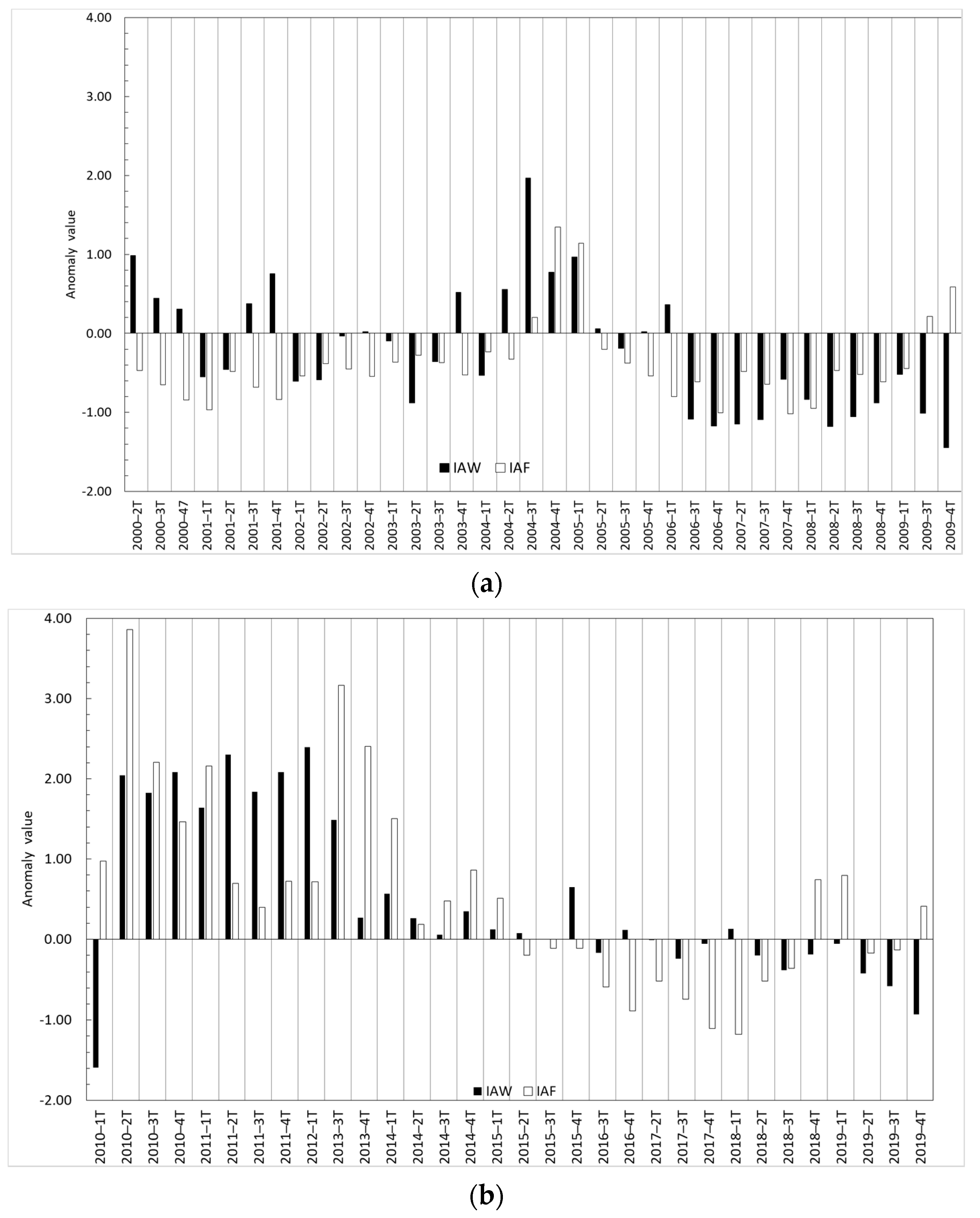
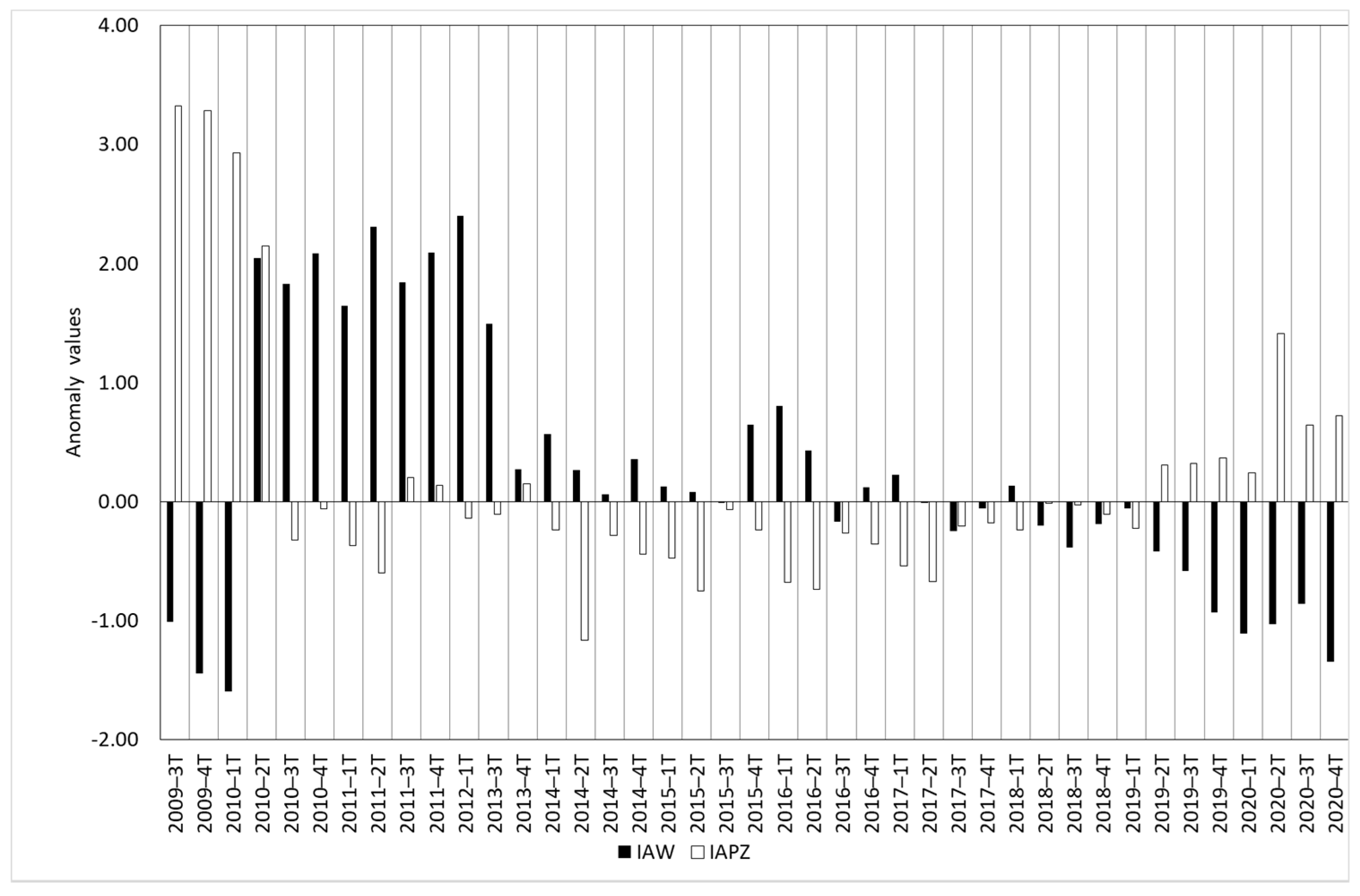


| IAW | IAF | IAF | ||||
|---|---|---|---|---|---|---|
| Spearman Coefficient | p-Value | Spearman Coefficient | p-Value | Spearman Coefficient | p-Value | |
| IAP | −0.049 | 0.677 | ||||
| IAF | 0.369 | 0.003 | ||||
| IAPZ | −0.406 | 0.009 | 0.109 | 0.544 | ||
| IAP | 0.087 | 0.488 | ||||
Disclaimer/Publisher’s Note: The statements, opinions and data contained in all publications are solely those of the individual author(s) and contributor(s) and not of MDPI and/or the editor(s). MDPI and/or the editor(s) disclaim responsibility for any injury to people or property resulting from any ideas, methods, instructions or products referred to in the content. |
© 2023 by the authors. Licensee MDPI, Basel, Switzerland. This article is an open access article distributed under the terms and conditions of the Creative Commons Attribution (CC BY) license (https://creativecommons.org/licenses/by/4.0/).
Share and Cite
Pena-Regueiro, J.; Estornell, J.; Aguilar-Maldonado, J.; Sebastiá-Frasquet, M.-T. Remote Sensing Temporal Reconstruction of the Flooded Area in “Tablas de Daimiel” Inland Wetland 2000–2021. Sensors 2023, 23, 4096. https://doi.org/10.3390/s23084096
Pena-Regueiro J, Estornell J, Aguilar-Maldonado J, Sebastiá-Frasquet M-T. Remote Sensing Temporal Reconstruction of the Flooded Area in “Tablas de Daimiel” Inland Wetland 2000–2021. Sensors. 2023; 23(8):4096. https://doi.org/10.3390/s23084096
Chicago/Turabian StylePena-Regueiro, Jesús, Javier Estornell, Jesús Aguilar-Maldonado, and Maria-Teresa Sebastiá-Frasquet. 2023. "Remote Sensing Temporal Reconstruction of the Flooded Area in “Tablas de Daimiel” Inland Wetland 2000–2021" Sensors 23, no. 8: 4096. https://doi.org/10.3390/s23084096
APA StylePena-Regueiro, J., Estornell, J., Aguilar-Maldonado, J., & Sebastiá-Frasquet, M.-T. (2023). Remote Sensing Temporal Reconstruction of the Flooded Area in “Tablas de Daimiel” Inland Wetland 2000–2021. Sensors, 23(8), 4096. https://doi.org/10.3390/s23084096


