A Quantitative Study of a Directional Heat Island in Hefei, China Based on Multi-Source Data
Abstract
1. Introduction
2. Materials and Methods
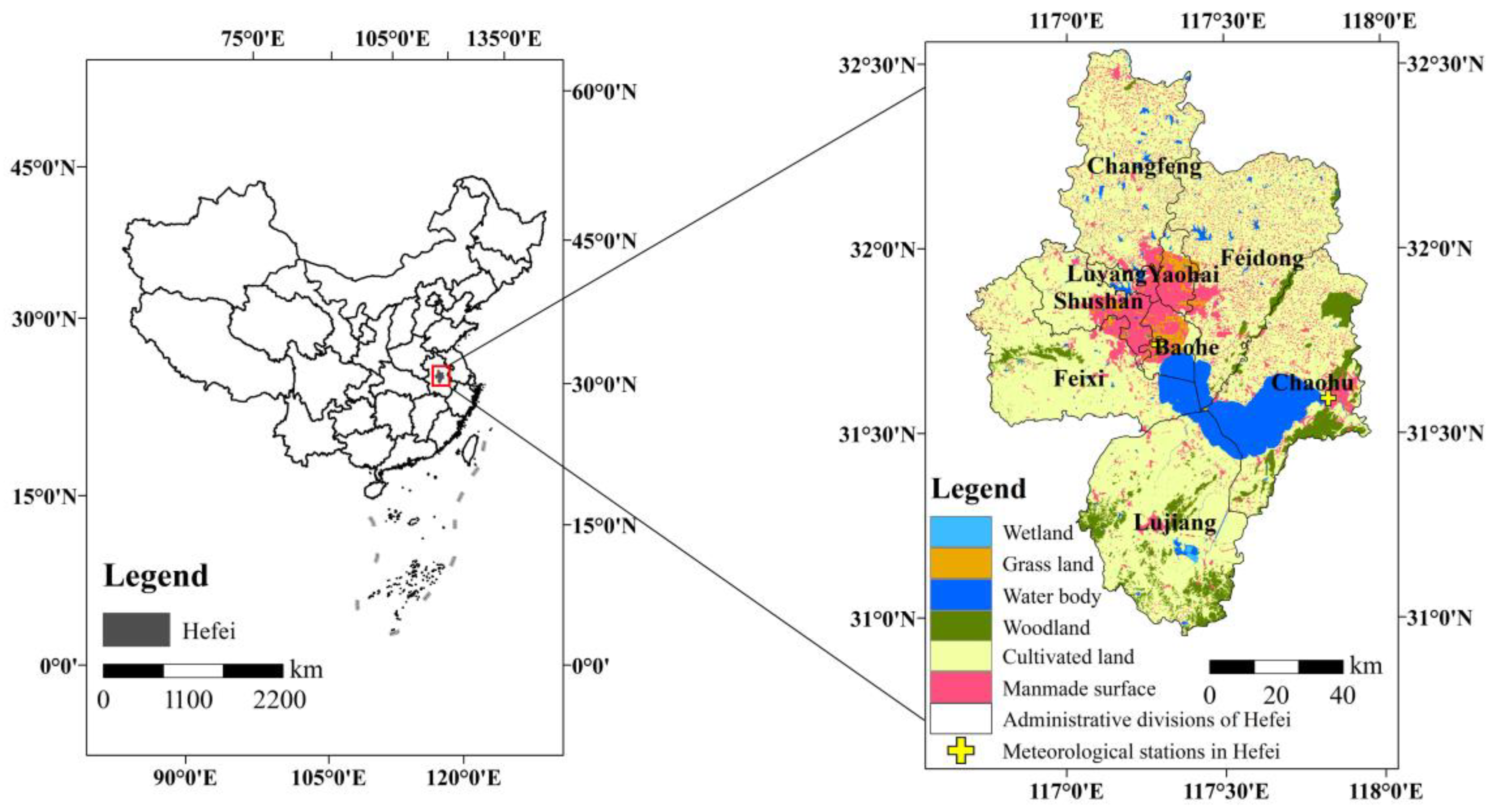
2.1. Study Area
2.2. Data
2.3. Methodology
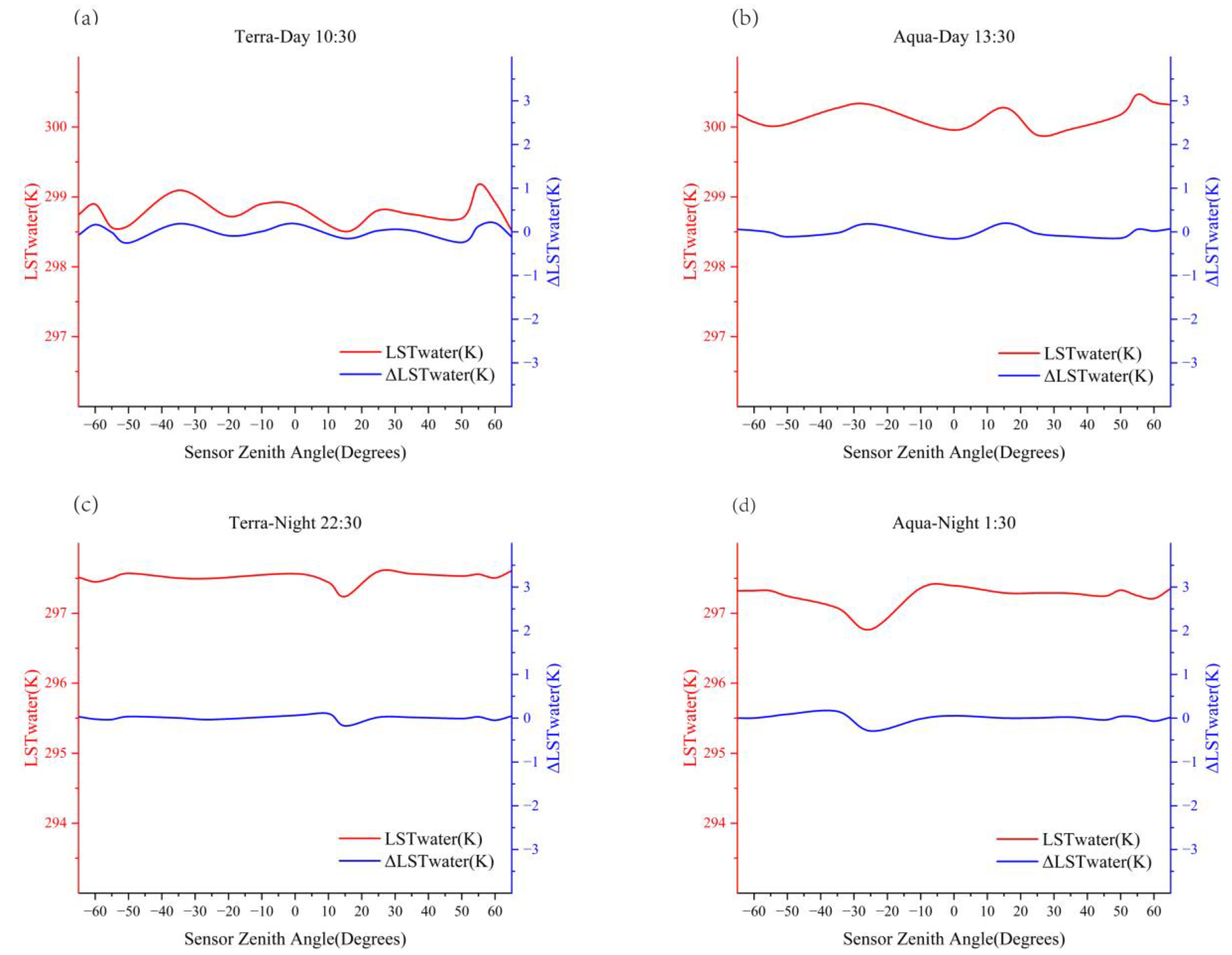
2.3.1. Separating the Angular Effect of Atmospheric Attenuation
2.3.2. Separating the Effect of Daily Weather Variations
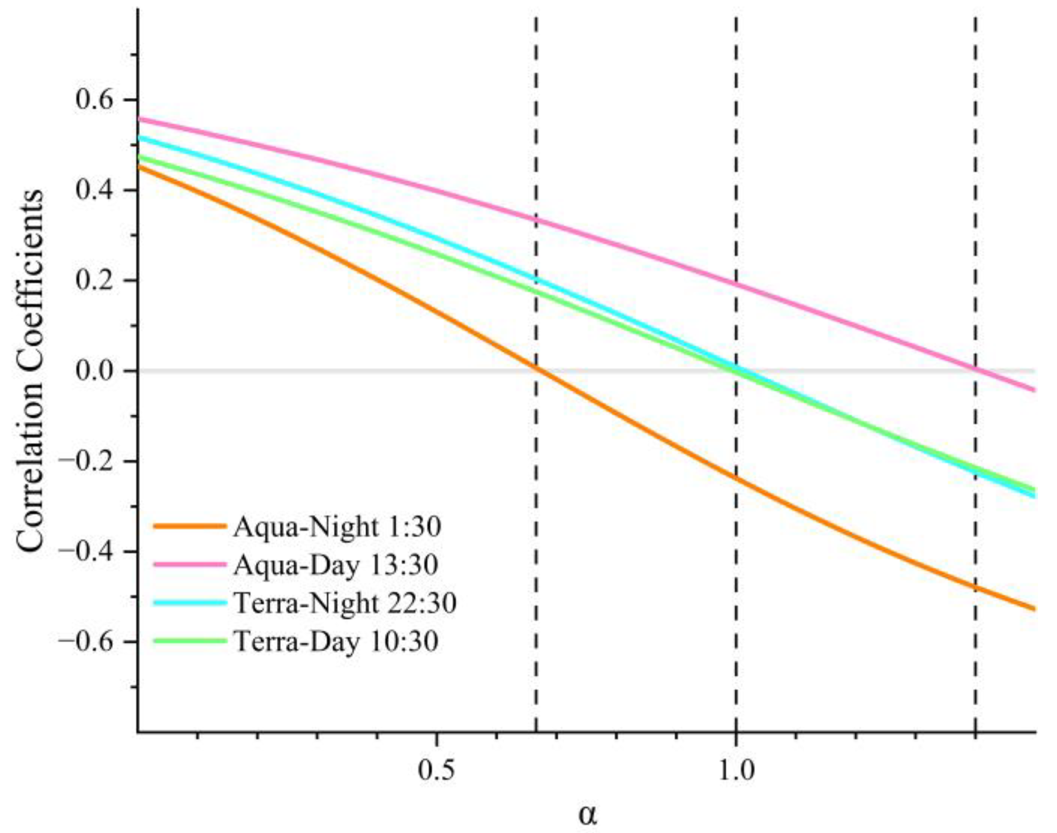
2.3.3. Relationship between SUHI Intensity and TRD
3. Results
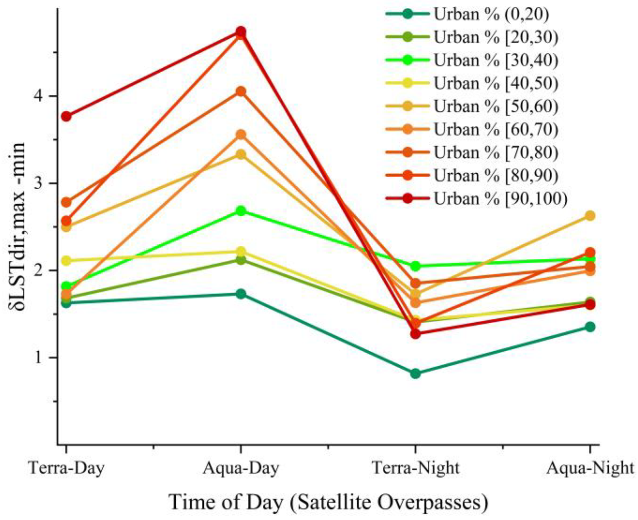
3.1. Spatial and Temporal Distribution Characteristics of TRD
3.2. Influence of TRD on SUHI Quantification
4. Discussion
5. Conclusions
Author Contributions
Funding
Institutional Review Board Statement
Informed Consent Statement
Data Availability Statement
Acknowledgments
Conflicts of Interest
References
- Li, Z.L.; Tang, B.H.; Wu, H.; Ren, H.Z.; Yan, G.J.; Wan, Z.M.; Trigo, I.F.; Sobrino, J.A. Satellite-derived land surface temperature: Current status and perspectives. Remote Sens. Environ. 2013, 131, 14–37. [Google Scholar] [CrossRef]
- Sobrino, J.A.; Jimenez-Munoz, J.C. Minimum configuration of thermal infrared bands for land surface temperature and emissivity estimation in the context of potential future missions. Remote Sens. Environ. 2014, 148, 158–167. [Google Scholar] [CrossRef]
- Urbanski, J.A.; Wochna, A.; Bubak, I.; Grzybowski, W.; Lukawska-Matuszewska, K.; Lacka, M.; Sliwinska, S.; Wojtasiewicz, B.; Zajaczkowski, M. Application of Landsat 8 imagery to regional-scale assessment of lake water quality. Int. J. Appl. Earth Obs. 2016, 51, 28–36. [Google Scholar]
- Voogt, J.A.; Oke, T.R. Thermal remote sensing of urban climates. Remote Sens. Environ. 2003, 86, 370–384. [Google Scholar] [CrossRef]
- Duan, S.B.; Li, Z.L.; Leng, P. A framework for the retrieval of all-weather land surface temperature at a high spatial resolution from polar-orbiting thermal infrared and passive microwave data. Remote Sens. Environ. 2017, 195, 107–117. [Google Scholar] [CrossRef]
- Jiang, Y.; Lin, W.P. A Comparative Analysis of Retrieval Algorithms of Land Surface Temperature from Landsat-8 Data: A Case Study of Shanghai, China. Int. J. Environ. Res. Public Health 2021, 18, 5659. [Google Scholar] [CrossRef] [PubMed]
- Ye, X.; Ren, H.Z.; Zhu, J.S.; Fan, W.J.; Qin, Q.M. Split-Window Algorithm for Land Surface Temperature Retrieval from Landsat-9 Remote Sensing Images. IEEE Geosci. Remote Sens. Lett. 2022, 19, 1–5. [Google Scholar] [CrossRef]
- Zheng, X.P.; Li, Z.L.; Wang, T.X.; Huang, H.B.; Nerry, F. Determination of global land surface temperature using data from only five selected thermal infrared channels: Method extension and accuracy assessment. Remote Sens. Environ. 2022, 268, 112774. [Google Scholar] [CrossRef]
- Ma, Y.F.; Liu, S.M.; Song, L.S.; Xu, Z.W.; Liu, Y.L.; Xu, T.R.; Zhu, Z.L. Estimation of daily evapotranspiration and irrigation water efficiency at a Landsat-like scale for an arid irrigation area using multi-source remote sensing data. Remote Sens. Environ. 2018, 216, 715–734. [Google Scholar] [CrossRef]
- Lai, J.; Zhan, W.; Quan, J.; Liu, Z.; Li, L.; Huang, F.; Hong, F.; Liao, W. Reconciling Debates on the Controls on Surface Urban Heat Island Intensity: Effects of Scale and Sampling. Geophys. Res. Lett. 2021, 48, e2021GL094485. [Google Scholar] [CrossRef]
- Liu, Z.; Zhan, W.; Lai, J.; Bechtel, B.; Lee, X.; Hong, F.; Li, L.; Huang, F.; Li, J. Taxonomy of seasonal and diurnal clear-sky climatology of surface urban heat island dynamics across global cities. ISPRS J. Photogramm. Remote Sens. 2022, 187, 14–33. [Google Scholar] [CrossRef]
- Zhan, W.; Ju, W.; Hai, S.; Ferguson, G.; Quan, J.; Tang, C.; Guo, Z.; Kong, F. Satellite-Derived Subsurface Urban Heat Island. Environ. Sci. Technol. 2014, 48, 12134–12140. [Google Scholar] [CrossRef] [PubMed]
- Zhan, W.; Liu, Z.; Bechtel, B.; Li, J.; Lai, J.; Fu, H.; Li, L.; Huang, F.; Wang, C.; Chen, Y. Urban-Rural Gradient in Urban Heat Island Variations Responsive to Large-scale Human Activity Changes during Chinese New Year Holiday. Geophys. Res. Lett. 2022, 49, e2022GL100689. [Google Scholar] [CrossRef]
- Sekertekin, A.; Arslan, N. Monitoring thermal anomaly and radiative heat flux using thermal infrared satellite imagery—A case study at Tuzla geothermal region. Geothermics 2019, 78, 243–254. [Google Scholar] [CrossRef]
- Alvarez-Mendoza, C.I.; Teodoro, A.; Ramirez-Cando, L. Spatial estimation of surface ozone concentrations in Quito Ecuador with remote sensing data, air pollution measurements and meteorological variables. Environ. Monit. Assess. 2019, 191, 155. [Google Scholar] [CrossRef]
- Liu, Y.; Fang, X.Y.; Zhang, S.; Luan, Q.; Quan, W.J. Research on quantitative evaluations of heat islands for the Beijing-Tianjin-Hebei Urban Agglomeration. Shengtai Xuebao/Acta Ecol. Sin. 2017, 37, 5818–5835. [Google Scholar]
- Xue, X.; He, T.; Xu, L.; Tong, C.; Ye, Y.; Liu, H.; Xu, D.; Zheng, X. Quantifying the spatial pattern of urban heat islands and the associated cooling effect of blue–green landscapes using multisource remote sensing data. Sci. Total Environ. 2022, 843, 156829. [Google Scholar] [CrossRef] [PubMed]
- Zhang, Y.T.; Li, D.L.; Liu, L.B.; Liang, Z.; Shen, J.S.; Wei, F.L.; Li, S.C. Spatiotemporal Characteristics of the Surface Urban Heat Island and Its Driving Factors Based on Local Climate Zones and Population in Beijing, China. Atmosphere 2021, 12, 1271. [Google Scholar] [CrossRef]
- Hu, J.; Yang, Y.; Zhou, Y.; Zhang, T.; Ma, Z.; Meng, X. Spatial patterns and temporal variations of footprint and intensity of surface urban heat island in 141 China cities. Sustain. Cities Soc. 2021, 77, 103585. [Google Scholar] [CrossRef]
- Ejiagha, I.R.; Ahmed, M.R.; Dewan, A.; Gupta, A.; Rangelova, E.; Hassan, Q.K. Urban Warming of the Two Most Populated Cities in the Canadian Province of Alberta, and Its Influencing Factors. Sensors 2022, 22, 2894. [Google Scholar] [CrossRef] [PubMed]
- Mohammad, P.; Goswami, A.; Bonafoni, S. The Impact of the Land Cover Dynamics on Surface Urban Heat Island Variations in Semi-Arid Cities: A Case Study in Ahmedabad City, India, Using Multi-Sensor/Source Data. Sensors 2019, 19, 3701. [Google Scholar] [CrossRef]
- Bokaie, M.; Zarkesh, M.K.; Arasteh, P.D.; Hosseini, A. Assessment of Urban Heat Island based on the relationship between land surface temperature and Land Use/Land Cover in Tehran. Sustain. Cities Soc. 2016, 23, 94–104. [Google Scholar] [CrossRef]
- Cai, Y.; Zhang, H.; Zheng, P.; Pan, W. Quantifying the Impact of Land use/Land Cover Changes on the Urban Heat Island: A Case Study of the Natural Wetlands Distribution Area of Fuzhou City, China. Wetlands 2016, 36, 285–298. [Google Scholar] [CrossRef]
- Su, Y.-F.; Foody, G.M.; Cheng, K.-S. Spatial non-stationarity in the relationships between land cover and surface temperature in an urban heat island and its impacts on thermally sensitive populations. Landsc. Urban Plan. 2012, 107, 172–180. [Google Scholar] [CrossRef]
- Abulibdeh, A. Analysis of urban heat island characteristics and mitigation strategies for eight arid and semi-arid gulf region cities. Environ. Earth Sci. 2021, 80, 259. [Google Scholar] [CrossRef]
- Amir Siddique, M.; Wang, Y.; Xu, N.; Ullah, N.; Zeng, P. The Spatiotemporal Implications of Urbanization for Urban Heat Islands in Beijing: A Predictive Approach Based on CA–Markov Modeling (2004–2050). Remote Sens. 2021, 13, 4697. [Google Scholar] [CrossRef]
- Han, J.; Zhao, X.; Zhang, H.; Liu, Y. Analyzing the Spatial Heterogeneity of the Built Environment and Its Impact on the Urban Thermal Environment—Case Study of Downtown Shanghai. Sustainability 2021, 13, 11302. [Google Scholar] [CrossRef]
- Liu, F.; Hou, H.; Murayama, Y. Spatial Interconnections of Land Surface Temperatures with Land Cover/Use: A Case Study of Tokyo. Remote Sens. 2021, 13, 610. [Google Scholar] [CrossRef]
- Sidiqui, P.; Tariq, M.A.; Ng, A.W.M. An Investigation to Identify the Effectiveness of Socioeconomic, Demographic, and Buildings’ Characteristics on Surface Urban Heat Island Patterns. Sustainability 2022, 14, 2777. [Google Scholar]
- Erdem Okumus, D.; Terzi, F. Evaluating the role of urban fabric on surface urban heat island: The case of Istanbul. Sustain. Cities Soc. 2021, 73, 103128. [Google Scholar] [CrossRef]
- Shi, L.; Ling, F.; Foody, G.M.; Yang, Z.; Liu, X.; Du, Y. Seasonal SUHI Analysis Using Local Climate Zone Classification: A Case Study of Wuhan, China. Int. J. Environ. Res. Public Health 2021, 18, 7242. [Google Scholar] [CrossRef] [PubMed]
- Shi, Y.; Xiang, Y.; Zhang, Y. Urban Design Factors Influencing Surface Urban Heat Island in the High-Density City of Guangzhou Based on the Local Climate Zone. Sensors 2019, 19, 3459. [Google Scholar] [CrossRef] [PubMed]
- Johnson, D.P. Population-Based Disparities in U.S. Urban Heat Exposure from 2003 to 2018. Int. J. Environ. Res. Public Health 2022, 19, 12314. [Google Scholar] [CrossRef]
- Wu, Y.; Hou, H.; Wang, R.; Murayama, Y.; Wang, L.; Hu, T. Effects of landscape patterns on the morphological evolution of surface urban heat island in Hangzhou during 2000–2020. Sustain. Cities Soc. 2022, 79, 103717. [Google Scholar] [CrossRef]
- Lagouarde, J.P.; Henon, A.; Irvine, M.; Voogt, J.; Pigeon, G.; Moreau, P.; Masson, V.; Mestayer, P. Experimental characterization and modelling of the nighttime directional anisotropy of thermal infrared measurements over an urban area: Case study of Toulouse (France). Remote Sens. Environ. 2012, 117, 19–33. [Google Scholar] [CrossRef]
- Monteith, J.L.; Szeicz, G. Radiative temperature in the heat balance of natural surfaces. Q. J. R. Meteorol. Soc. 1962, 88, 496–507. [Google Scholar] [CrossRef]
- Kimes, D.S. Remote Sensing of Temperature Profiles in Vegetation Canopies Using Multiple View Angles And Inversion Techniques. IEEE Trans. Geosci. Remote Sens. 1981, 2, 85–90. [Google Scholar] [CrossRef]
- Merlin, O.; Chehbouni, A. Different approaches in estimating heat flux using dual angle observations of radiative surface temperature. Int. J. Remote Sens. 2004, 25, 275–289. [Google Scholar] [CrossRef]
- Jun, L.; Hao, S.; Qinan, L.; Xuejia, C.; Chong, L.; Huaguo, H. Field observations of background thermal radiation directionality in natural forests. J. Remote Sens. 2017, 21, 365–374. [Google Scholar]
- Cao, B.; Guo, M.; Fan, W.; Xu, X.; Peng, J.; Ren, H.; Du, Y.; Li, H.; Bian, Z.; Hu, T.; et al. A New Directional Canopy Emissivity Model Based on Spectral Invariants. IEEE Trans. Geosci. Remote Sens. 2018, 56, 6911–6926. [Google Scholar] [CrossRef]
- Adderley, C.; Christen, A.; Voogt, J.A. The effect of radiometer placement and view on inferred directional and hemispheric radiometric temperatures of an urban canopy. Atmos. Meas. Technol. 2015, 8, 2699–2714. [Google Scholar] [CrossRef]
- Lagouarde, J.P.; Moreau, P.; Irvine, M.; Bonnefond, J.M.; Voogt, J.A.; Solliec, F. Airborne experimental measurements of the angular variations in surface temperature over urban areas: Case study of Marseille (France). Remote Sens. Environ. 2004, 93, 443–462. [Google Scholar] [CrossRef]
- Jiang, L.; Zhan, W.F.; Tu, L.L.; Dong, P.; Wang, S.S.; Li, L.; Wang, C.L.; Wang, C.G. Diurnal variations in directional brightness temperature over urban areas through a multi-angle UAV experiment. Build. Environ. 2022, 222, 109408. [Google Scholar] [CrossRef]
- Lagouarde, J.-P.; Irvine, M. Directional anisotropy in thermal infrared measurements over Toulouse city centre during the CAPITOUL measurement campaigns: First results. Meteorol. Atmos. Phys. 2008, 102, 173–185. [Google Scholar] [CrossRef]
- Hu, L.Q.; Monaghan, A.; Voogt, J.A.; Barlage, M. A first satellite-based observational assessment of urban thermal anisotropy. Remote Sens. Environ. 2016, 181, 111–121. [Google Scholar] [CrossRef]
- Wang, D.; Chen, Y.; Hu, L.; Voogt, J.A. Urban Thermal Anisotropy: A Comparison among Observational and Modeling Approaches at Different Time Scales. IEEE Trans. Geosci. Remote Sens. 2022, 60, 1–15. [Google Scholar] [CrossRef]
- Coll, C.; Galve, J.M.; Niclos, R.; Valor, E.; Barbera, M.J. Angular variations of brightness surface temperatures derived from dual-view measurements of the Advanced Along-Track Scanning Radiometer using a new single band atmospheric correction method. Remote Sens. Environ. 2019, 223, 274–290. [Google Scholar] [CrossRef]
- Chen, S.; Ren, H.; Ye, X.; Dong, J.; Zheng, Y. Geometry and adjacency effects in urban land surface temperature retrieval from high-spatial-resolution thermal infrared images. Remote Sens. Environ. 2021, 262, 112518. [Google Scholar] [CrossRef]
- Krayenhoff, E.S.; Voogt, J.A. Daytime Thermal Anisotropy of Urban Neighbourhoods: Morphological Causation. Remote Sens. 2016, 8, 108. [Google Scholar] [CrossRef]
- Ru, C.; Duan, S.B.; Jiang, X.G.; Li, Z.L.; Jiang, Y.; Ren, H.; Leng, P.; Gao, M. Land Surface Temperature Retrieval from Landsat 8 Thermal Infrared Data over Urban Areas Considering Geometry Effect: Method and Application. IEEE Trans. Geosci. Remote Sens. 2022, 60, 1–16. [Google Scholar] [CrossRef]
- Wang, D.; Chen, Y.; Hu, L.; Voogt, J.A.; Gastellu-Etchegorry, J.-P.; Krayenhoff, E.S. Modeling the angular effect of MODIS LST in urban areas: A case study of Toulouse, France. Remote Sens. Environ. 2021, 257, 112361. [Google Scholar] [CrossRef]
- Wang, D.D.; Chen, Y.H. A Geometric Model to Simulate Urban Thermal Anisotropy in Simplified Dense Neighborhoods (GUTA-Dense). IEEE Trans. Geosci. Remote Sens. 2019, 57, 6226–6239. [Google Scholar] [CrossRef]
- Christen, A.; Meier, F.; Scherer, D. High-frequency fluctuations of surface temperatures in an urban environment. Theor. Appl. Climatol. 2012, 108, 301–324. [Google Scholar] [CrossRef]
- Pasha, Y.S.; Afshari, A. Assessment and Improvement of the Accuracy of Radiation Heat Transfer Estimation in Simplified Urban Canopy Models. Energy Procedia 2017, 143, 532–539. [Google Scholar] [CrossRef]
- Hilland, R.V.J.; Voogt, J.A. The effect of sub-facet scale surface structure on wall brightness temperatures at multiple scales. Theor. Appl. Climatol. 2020, 140, 767–785. [Google Scholar] [CrossRef]
- Hu, L.; Wendel, J. Analysis of urban surface morphologic effects on diurnal thermal directional anisotropy. ISPRS J. Photogramm. Remote Sens. 2019, 148, 1–12. [Google Scholar] [CrossRef]
- Pinheiro, A.C.T.; Privette, J.L.; Mahoney, R.; Tucker, C.J. Directional effects in a daily AVHRR land surface temperature dataset over Africa. IEEE Trans. Geosci. Remote Sens. 2004, 42, 1941–1954. [Google Scholar] [CrossRef]
- Wu, X. Construction and application of urban geospatial infrastructure framework in Hefei. Urban Geotech. Investig. Surv. 2007, 22, 23–25. [Google Scholar]
- Yao, X.; Chen, Y.; Zhang, Q.; Mou, Z.; Yao, X.; Ou, C. Assessment of the Urban Expansion and Its Impact on the Eco-Environment—A Case Study of Hefei Municipal Area. Sustainability 2022, 14, 10613. [Google Scholar] [CrossRef]
- Chen, X.; Yang, X.; Dong, X.; Liu, E. Environmental changes in Chaohu Lake (southeast, China) since the mid 20th century: The interactive impacts of nutrients, hydrology and climate. Limnologica 2013, 43, 10–17. [Google Scholar] [CrossRef]
- Yang, L.; Lei, K.; Meng, W.; Fu, G.; Yan, W. Temporal and spatial changes in nutrients and chlorophyll-α in a shallow lake, Lake Chaohu, China: An 11-year investigation. J. Environ. Sci. 2013, 25, 1117–1123. [Google Scholar] [CrossRef]
- Ren, H.Z.; Yan, G.J.; Liu, R.Y.; Li, Z.L.; Qin, Q.M.; Nerry, F.; Liu, Q. Determination of Optimum Viewing Angles for the Angular Normalization of Land Surface Temperature over Vegetated Surface. Sensors 2015, 15, 7537–7570. [Google Scholar] [CrossRef]
- Niclos, R.; Caselles, V.; Coll, C.; Valor, E.; Rubio, E. Autonomous measurements of sea surface temperature using in situ thermal infrared data. J. Atmos. Ocean. Technol. 2004, 21, 683–692. [Google Scholar] [CrossRef]
- Niclos, R.; Valor, E.; Caselles, V.; Coll, C.; Sanchez, J.M. In situ angular measurements of thermal infrared sea surface emissivity—Validation of models. Remote Sens. Environ. 2005, 94, 83–93. [Google Scholar] [CrossRef]
- Wan, Z.; Dozier, J. A generalized split-window algorithm for retrieving land-surface temperature from space. IEEE Trans. Geosci. Remote Sens. 1996, 34, 892–905. [Google Scholar]
- Benali, A.; Carvalho, A.C.; Nunes, J.P.; Carvalhais, N.; Santos, A. Estimating air surface temperature in Portugal using MODIS LST data. Remote Sens. Environ. 2012, 124, 108–121. [Google Scholar] [CrossRef]
- Prihodko, L.; Goward, S.N. Estimation of air temperature from remotely sensed surface observations. Remote Sens. Environ. 1997, 60, 335–346. [Google Scholar] [CrossRef]
- Hu, L.Q.; Brunsell, N.A. A new perspective to assess the urban heat island through remotely sensed atmospheric profiles. Remote Sens. Environ. 2015, 158, 393–406. [Google Scholar] [CrossRef]
- Monaghan, A.J.; Hu, L.Q.; Brunsell, N.A.; Barlage, M.; Wilhelmi, O.V. Evaluating the impact of urban morphology configurations on the accuracy of urban canopy model temperature simulations with MODIS. J. Geophys. Res. Atmos. 2014, 119, 6376–6392. [Google Scholar] [CrossRef]
- Oke, T.R.; Johnson, G.T.; Steyn, D.G.; Watson, I.D. Simulation of surface urban heat islands under ‘ideal’ conditions at night part 2: Diagnosis of causation. Bound.-Layer Meteorol. 1991, 56, 339–358. [Google Scholar] [CrossRef]
- Voogt, J.A.; Oke, T.R. Effects of urban surface geometry on remotely-sensed surface temperature. Int. J. Remote Sens. 1998, 19, 895–920. [Google Scholar] [CrossRef]
- Roth, M.; Oke, T.R.; Emery, W.J. Satellite-derived urban heat islands from three coastal cities and the utilization of such data in urban climatology. Int. J. Remote Sens. 1989, 10, 1699–1720. [Google Scholar] [CrossRef]
- Hu, L.Q.; Brunsell, N.A.; Monaghan, A.J.; Barlage, M.; Wilhelmi, O.V. How can we use MODIS land surface temperature to validate long-term urban model simulations? J. Geophys. Res. Atmos. 2014, 119, 3185–3201. [Google Scholar] [CrossRef]


Disclaimer/Publisher’s Note: The statements, opinions and data contained in all publications are solely those of the individual author(s) and contributor(s) and not of MDPI and/or the editor(s). MDPI and/or the editor(s) disclaim responsibility for any injury to people or property resulting from any ideas, methods, instructions or products referred to in the content. |
© 2023 by the authors. Licensee MDPI, Basel, Switzerland. This article is an open access article distributed under the terms and conditions of the Creative Commons Attribution (CC BY) license (https://creativecommons.org/licenses/by/4.0/).
Share and Cite
Shi, B.; Tu, L.; Jiang, L.; Zhang, J.; Geng, J. A Quantitative Study of a Directional Heat Island in Hefei, China Based on Multi-Source Data. Sensors 2023, 23, 3041. https://doi.org/10.3390/s23063041
Shi B, Tu L, Jiang L, Zhang J, Geng J. A Quantitative Study of a Directional Heat Island in Hefei, China Based on Multi-Source Data. Sensors. 2023; 23(6):3041. https://doi.org/10.3390/s23063041
Chicago/Turabian StyleShi, Biao, Lili Tu, Lu Jiang, Jiyuan Zhang, and Jun Geng. 2023. "A Quantitative Study of a Directional Heat Island in Hefei, China Based on Multi-Source Data" Sensors 23, no. 6: 3041. https://doi.org/10.3390/s23063041
APA StyleShi, B., Tu, L., Jiang, L., Zhang, J., & Geng, J. (2023). A Quantitative Study of a Directional Heat Island in Hefei, China Based on Multi-Source Data. Sensors, 23(6), 3041. https://doi.org/10.3390/s23063041


