
GIS-Based Assessment of Hybrid Pumped Hydro Storage as a Potential Solution for the Clean Energy Transition: The Case of the Kardia Lignite Mine, Western Greece

 , ,
, ,  , ,
, ,  and
and
Abstract
1. Introduction
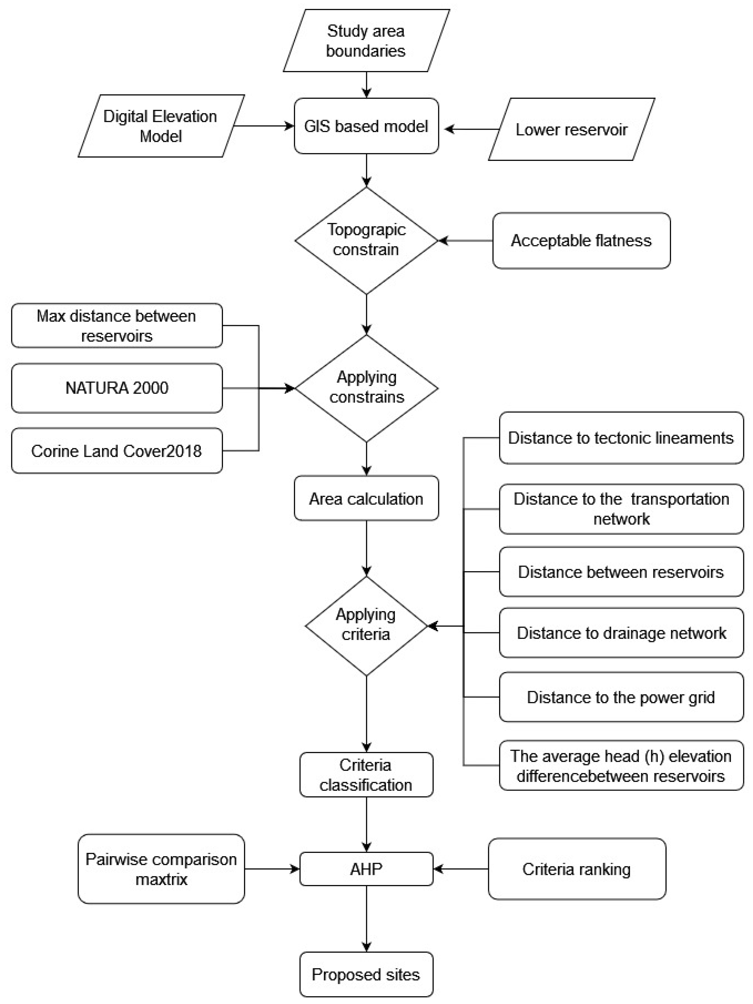
2. Materials and Methods
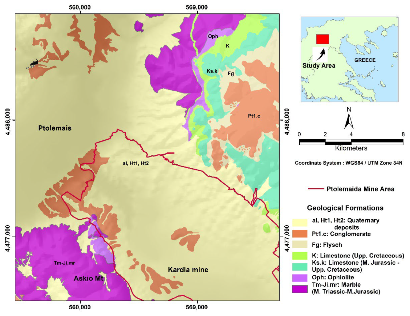
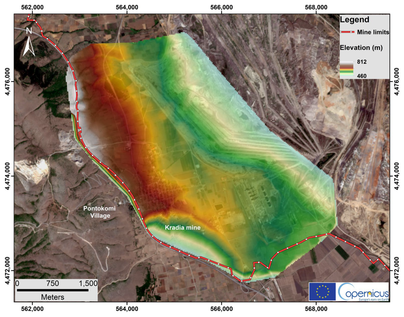
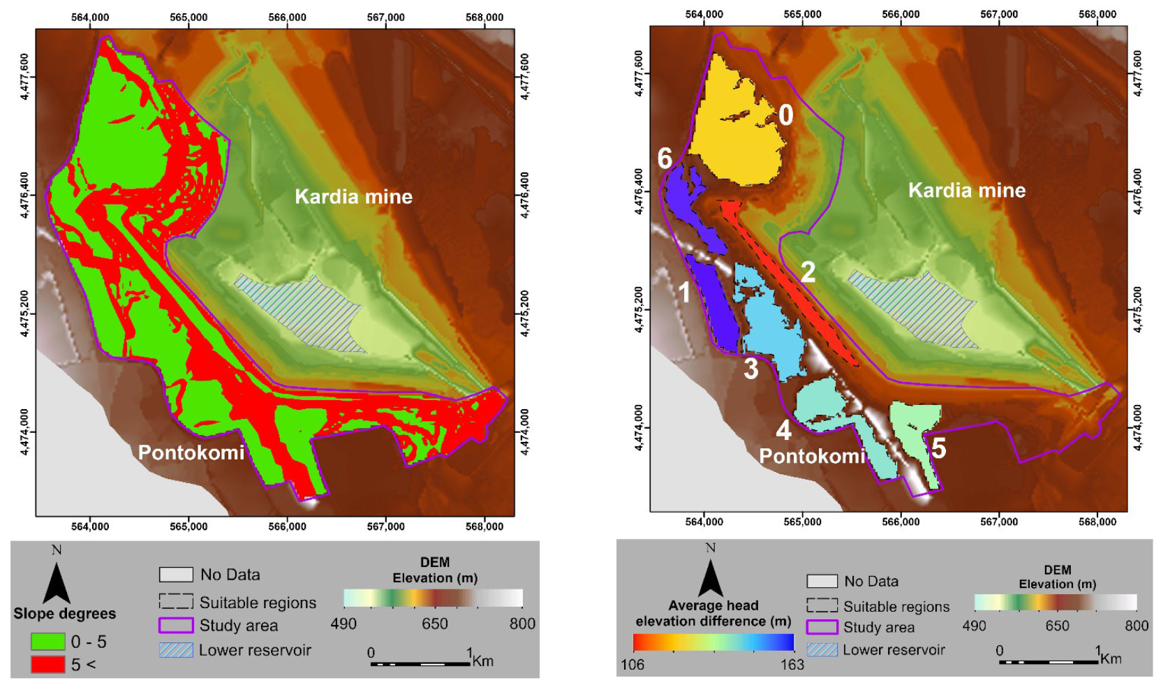
2.1. Study Area
2.2. Literature Review on Site Criteria Selection

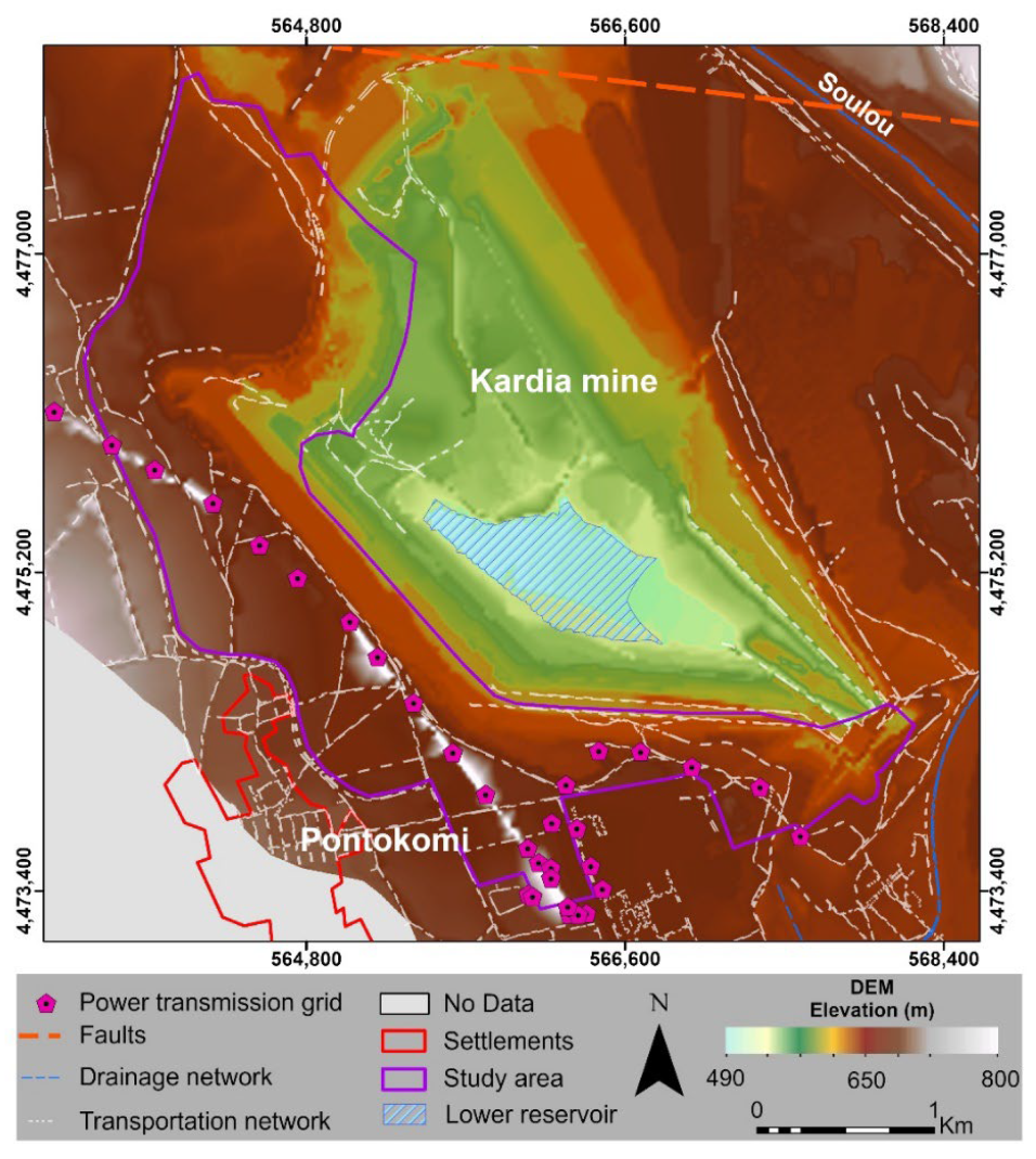
2.3. Data
2.4. Methodology
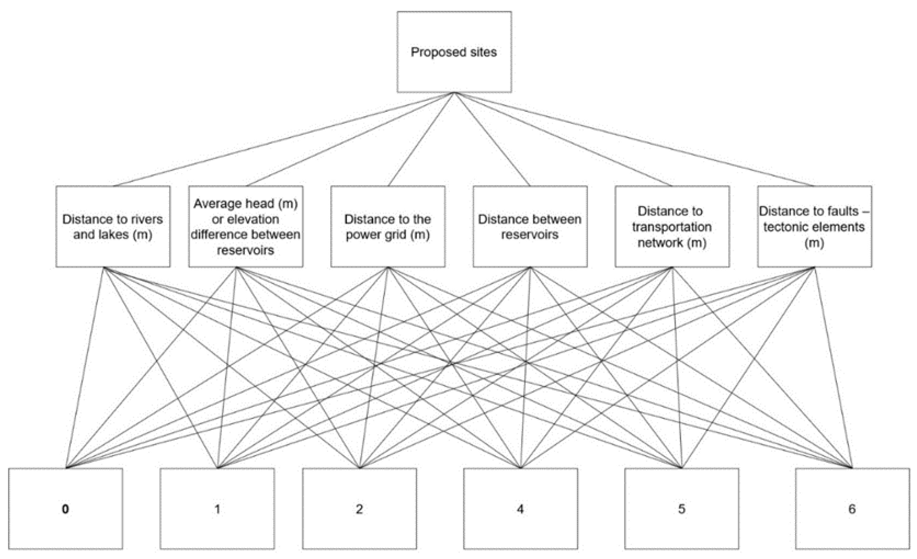
2.4.1. Criteria and Constrains
- 1.
- The existing location of the lower reservoir
- 2.
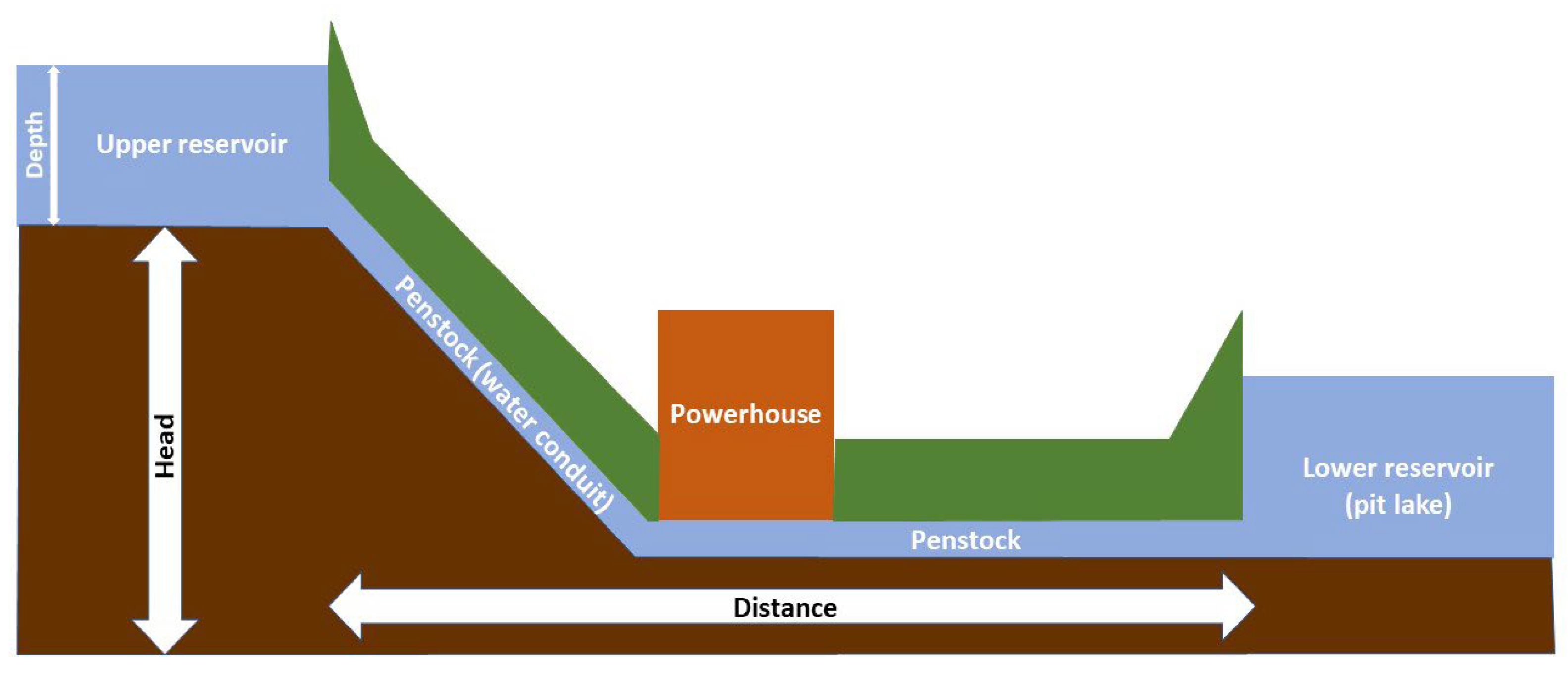
- Topography
- 3.
- Corine Land Cover
- 4.
- Natura 2000
- 5.
- Transportation network
- 6.
- Tectonic lineaments
- 7.
- Power transmission grid
- 8.
- Drainage network
2.4.2. Analytical Hierarchy Process (AHP)
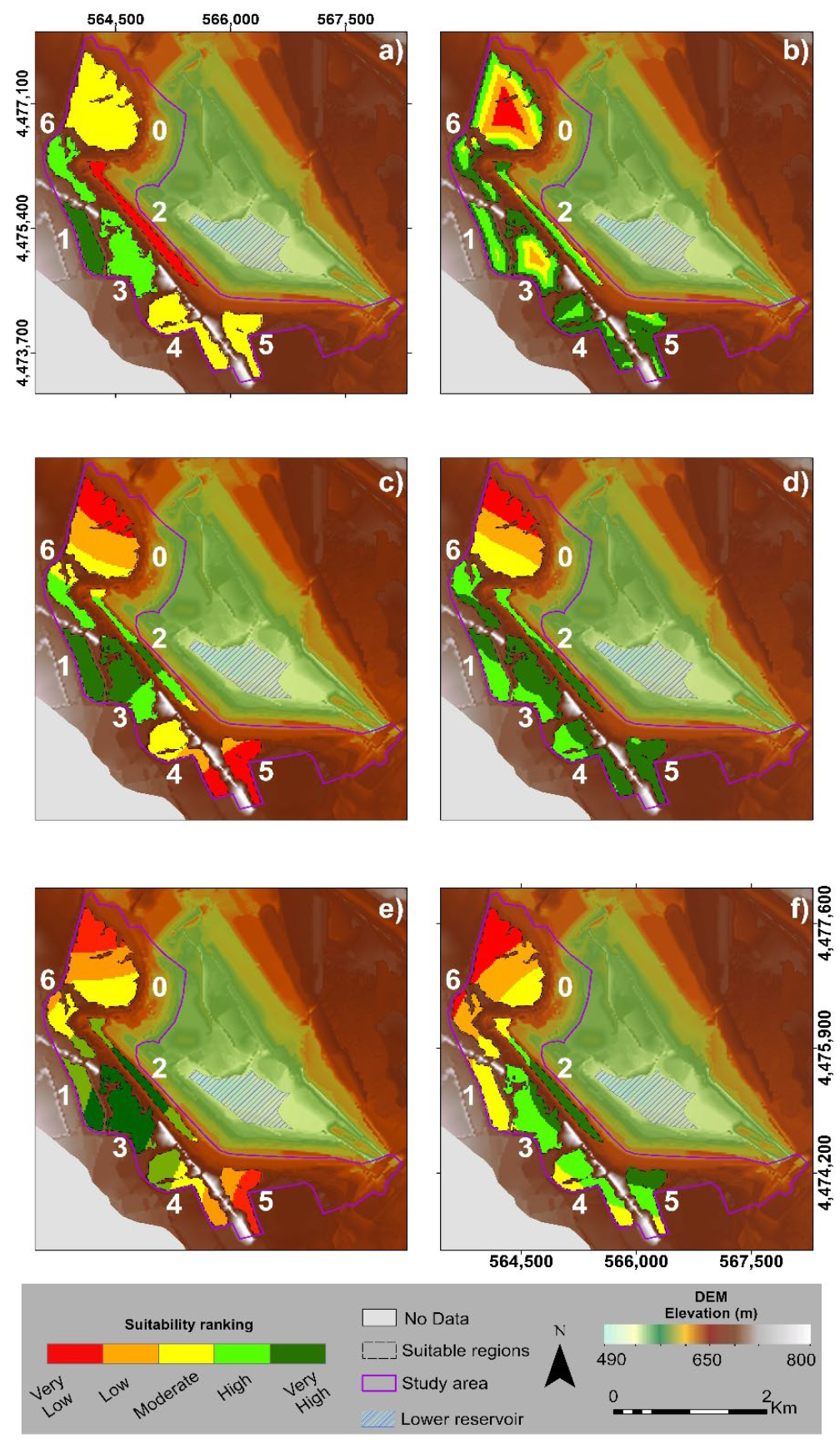
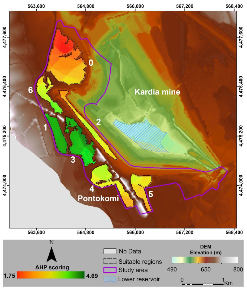
3. Results
3.1. Criteria Ranking
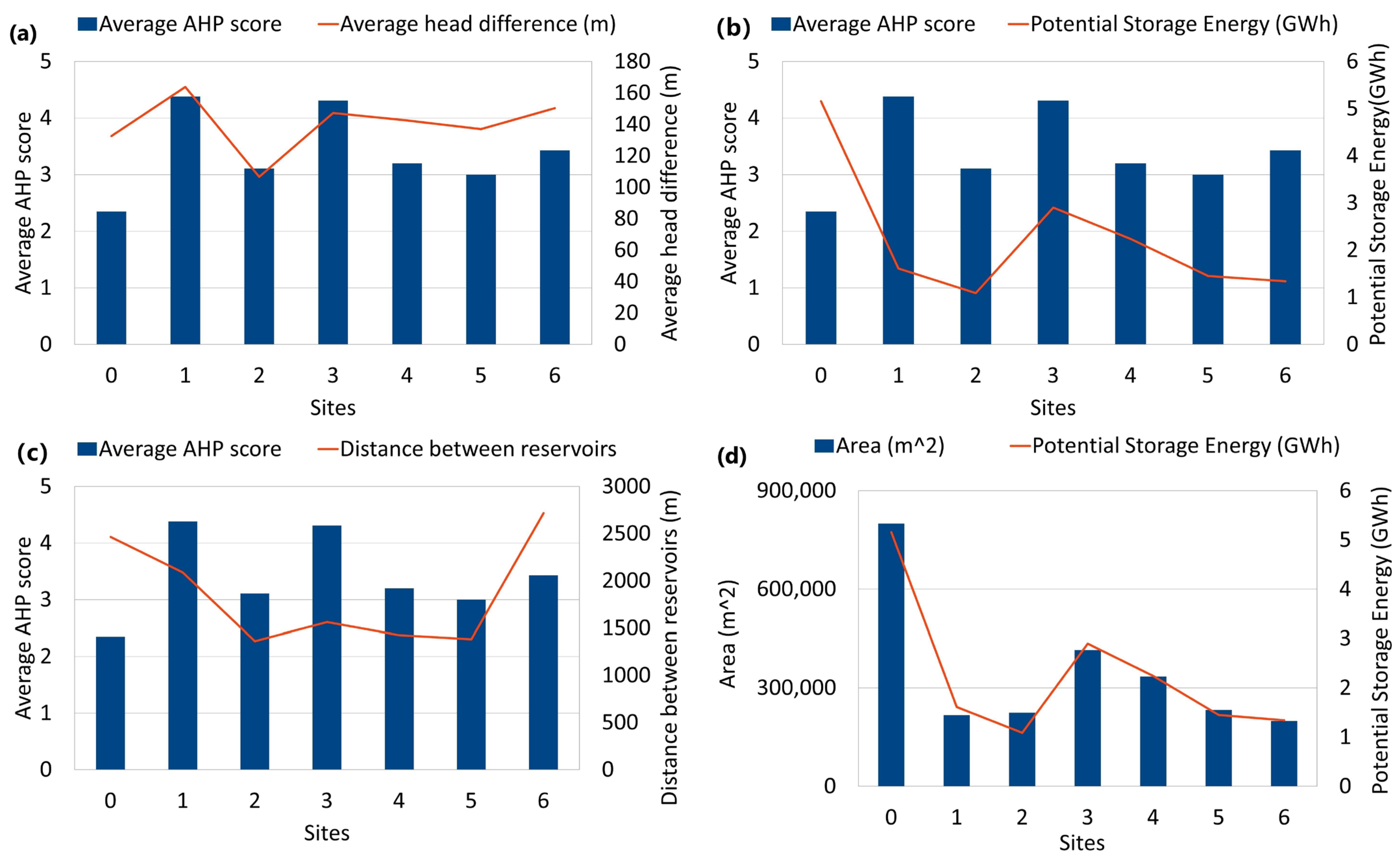
3.2. Storage Energy Capacity Estimation
3.3. Statistical Analysis of the Proposed Areas
4. Discussion
5. Conclusions
Author Contributions
Funding
Institutional Review Board Statement
Informed Consent Statement
Data Availability Statement
Acknowledgments
Conflicts of Interest
References
- UNFCCC. The Paris Agreement. In Proceedings of the Paris Climate Change Conference, Paris, France, 30 November 2015. [Google Scholar]
- Gilfillan, D.; Pittock, J. Pumped Storage Hydropower for Sustainable and Low-Carbon Electricity Grids in Pacific Rim Economies. Energies 2022, 15, 3139. [Google Scholar] [CrossRef]
- IEA. World Energy Outlook 2022; IEA: Paris, France, 2022. [Google Scholar]
- IEA. Energy Statistics Data Browser. Available online: https://www.iea.org/data-and-statistics/data-tools/energy-statistics-data-browser?country=WEOEUR&fuel=Energy%20supply&indicator=ElecGenByFuel (accessed on 10 November 2022).
- IHA. Annual Report 2022; IHA: Paris, France, 2022. [Google Scholar]
- Breeze, P. Chapter 10-Power System Energy Storage Technologies. In Power Generation Technologies, 3rd ed.; Breeze, P., Ed.; Newnes: London, UK, 2019; pp. 219–249. [Google Scholar] [CrossRef]
- Hunt, J.D.; Zakeri, B.; Lopes, R.; Barbosa, P.S.F.; Nascimento, A.; Castro, N.J.d.; Brandão, R.; Schneider, P.S.; Wada, Y. Existing and new arrangements of pumped-hydro storage plants. Renew. Sustain. Energy Rev. 2020, 129, 109914. [Google Scholar] [CrossRef]
- NHA. 2021 Pumped Storage Report; NHA: Washington, DC, USA, 2021; p. 36. [Google Scholar]
- Voith. 2020 Annual Report; Voith: Heidenheim, Germany, 2020. [Google Scholar]
- Javed, M.S.; Ma, T.; Jurasz, J.; Amin, M.Y. Solar and wind power generation systems with pumped hydro storage: Review and future perspectives. Renew. Energy 2020, 148, 176–192. [Google Scholar] [CrossRef]
- Alves Dias, P.; Kanellopoulos, K.; Medarac, H.; Kapetaki, Z.; Miranda-Barbosa, E.; Shortall, R.; Veronica, C.; Telsnig, T.; Cristina, V.-H.; Lacal Arantegui, R.; et al. Eu Coal Regions: Opportunities and Challenges Ahead; Publications Office of the European Union: Luxembourg, 2018. [Google Scholar] [CrossRef]
- European Commission. The European Green Deal; EC: Brussels, Belgium, 2019. [Google Scholar]
- IHA. Annual Report 2021; IHA: Lansing, MI, USA, 2021. [Google Scholar]
- Wessel, M.; Madlener, R.; Hilgers, C. Economic Feasibility of Semi-Underground Pumped Storage Hydropower Plants in Open-Pit Mines. Energies 2020, 13, 4178. [Google Scholar] [CrossRef]
- Vieira, F.; Ramos, H.M. Optimization of operational planning for wind/hydro hybrid water supply systems. Renew. Energy 2009, 34, 928–936. [Google Scholar] [CrossRef]
- Fitzgerald, N.; Lacal Arántegui, R.; McKeogh, E.; Leahy, P. A GIS-based model to calculate the potential for transforming conventional hydropower schemes and non-hydro reservoirs to pumped hydropower schemes. Energy 2012, 41, 483–490. [Google Scholar] [CrossRef]
- Lu, X.; Wang, S. A GIS-based assessment of Tibet’s potential for pumped hydropower energy storage. Renew. Sustain. Energy Rev. 2017, 69, 1045–1054. [Google Scholar] [CrossRef]
- Soha, T.; Munkácsy, B.; Harmat, Á.; Csontos, C.; Horváth, G.; Tamás, L.; Csüllög, G.; Daróczi, H.; Sáfián, F.; Szabó, M. GIS-based assessment of the opportunities for small-scale pumped hydro energy storage in middle-mountain areas focusing on artificial landscape features. Energy 2017, 141, 1363–1373. [Google Scholar] [CrossRef]
- Gimeno-Gutiérrez, M.; Lacal-Arántegui, R. Assessment of the European potential for pumped hydropower energy storage based on two existing reservoirs. Renew. Energy 2015, 75, 856–868. [Google Scholar] [CrossRef]
- Ghorbani, N.; Makian, H.; Breyer, C. A GIS-based method to identify potential sites for pumped hydro energy storage-Case of Iran. Energy 2019, 169, 854–867. [Google Scholar] [CrossRef]
- Nzotcha, U.; Kenfack, J.; Blanche Manjia, M. Integrated multi-criteria decision making methodology for pumped hydro-energy storage plant site selection from a sustainable development perspective with an application. Renew. Sustain. Energy Rev. 2019, 112, 930–947. [Google Scholar] [CrossRef]
- Delogkos, E.; Childs, C.; Manzocchi, T.; Walsh, J.J. The nature and origin of bed-parallel slip in Kardia Mine, Ptolemais Basin, Greece. J. Struct. Geol. 2018, 113, 115–133. [Google Scholar] [CrossRef]
- Krassakis, P.; Pyrgaki, K.; Gemeni, V.; Roumpos, C.; Louloudis, G.; Koukouzas, N. GIS-Based Subsurface Analysis and 3D Geological Modeling as a Tool for Combined Conventional Mining and In-Situ Coal Conversion: The Case of Kardia Lignite Mine, Western Greece. Mining 2022, 2, 297–314. [Google Scholar] [CrossRef]
- Koukouzas, N. Mineralogy and geochemistry of diatomite associated with lignite seams in the Komnina Lignite Basin, Ptolemais, Northern Greece. Int. J. Coal Geol. 2007, 71, 276–286. [Google Scholar] [CrossRef]
- Van Vugt, N.; Steenbrink, J.; Langereis, C.G.; Hilgen, F.J.; Meulenkamp, J.E. Magnetostratigraphy-based astronomical tuning of the early Pliocene lacustrine sediments of Ptolemais (NW Greece) and bed-to-bed correlation with the marine record. Earth Planet. Sci. Lett. 1998, 164, 535–551. [Google Scholar] [CrossRef]
- Steenbrink, J.; van Vugt, N.; Hilgen, F.J.; Wijbrans, J.R.; Meulenkamp, J.E. Sedimentary cycles and volcanic ash beds in the Lower Pliocene lacustrine succession of Ptolemais (NW Greece): Discrepancy between 40Ar/39Ar and astronomical ages. Palaeogeogr. Palaeoclimatol. Palaeoecol. 1999, 152, 283–303. [Google Scholar] [CrossRef]
- Koukouzas, N.; Ward, C.; Li, Z. Mineralogy of lignites and associated strata in the Mavropigi field of the Ptolemais Basin, northern Greece. Int. J. Coal Geol. 2010, 81, 182–190. [Google Scholar] [CrossRef]
- Roumpos, C.; Spanidis, P.-M.P.; Pavloudakis, F. Environmental Reclamation Planning of Continuous Surface Lignite Mines in Closure Phase: A Risk-Based Investigation. In Proceedings of the 14th International Symposium of Continuous Surface Mining, Thessaloniki, Greece, 20 December 2020. [Google Scholar]
- Koukouzas, N.; Krassakis, P.; Koutsovitis, P.; Karkalis, C. An integrated approach to the coal deposits in the Mesohellenic Trough, Greece. Bullet. Geol. Soc. Greece 2019, 54, 34–59. [Google Scholar] [CrossRef]
- Jacobsen, K. DEM Generation from Satellite Data. Available online: https://pdfs.semanticscholar.org/e066/f8a278f845bf2cb19c9b4e81ec4dde1e1131.pdf (accessed on 10 October 2022).
- Lacal Arántegui, R.; Leahy, P.; Fitzgerald, N.; Joint Research Centre; Institute for Energy and Transport. Pumped-Hydro Energy Storage: Potential for Transformation from Single Dams (Analysis of the Potential for Transformation of Non-Hydropower Dams and Reservoir Hydropower Schemes into Pumping Hydropower Schemes in Europe); Publications Office of the European Union: Luxembourg, 2012. [Google Scholar] [CrossRef]
- Kocaman, A.S.; Modi, V. Value of pumped hydro storage in a hybrid energy generation and allocation system. Appl. Energy 2017, 205, 1202–1215. [Google Scholar] [CrossRef]
- Petrakopoulou, F. On the economics of stand-alone renewable hybrid power plants in remote regions. Energy Convers. Manag. 2016, 118, 63–74. [Google Scholar] [CrossRef]
- E.ON. Pumped Hydro—Technical Concepts, Design Criteria An Current Development Options. 2014. Available online: https://kipdf.com/pumped-hydro-technical-concepts-design-criteria-an-current-development-options-g_5ac893bd1723ddcae10b8bc3.html (accessed on 10 October 2022).
- Kucukali, S. Finding the most suitable existing hydropower reservoirs for the development of pumped-storage schemes: An integrated approach. Renew. Sustain. Energy Rev. 2014, 37, 502–508. [Google Scholar] [CrossRef]
- Van de Vegte, H. Overview of Potential Locations for New Pumped Storage Plants in Eu 15, Switzerland And Norway; Deliverable 4.2 Final Report (project deliverable eSTORAGE 295367). 2015. [Google Scholar]
- EEA. Natura 2000 Data-The European Network of Protected Sites. Available online: https://www.eea.europa.eu/data-and-maps/data/natura-13 (accessed on 25 April 2022).
- OpenStreetMap. Available online: https://www.openstreetmap.org/#map=10/40.4448/21.6801 (accessed on 25 April 2022).
- Service, C.L.M. CORINE Land Cover; European Environment Agency: Copenhagen, Denmark, 2021; p. 129. [Google Scholar]
- James, G.; Witten, D.; Hastie, T.; Tibshirani, R. An Introduction to Statistical Learning; Springer: New York, NY, USA, 2013; Volume 112, p. 426. [Google Scholar]
- Krassakis, P.; Kazana, S.; Chen, F.; Koukouzas, N.; Parcharidis, I.; Lekkas, E. Detecting subsidence spatial risk distribution of ground deformation induced by urban hidden streams. Geocarto Int. 2021, 36, 622–639. [Google Scholar] [CrossRef]
- Nomikou, P.; Krassakis, P.; Kazana, S.; Papanikolaou, D.; Koukouzas, N. The Volcanic Relief within the Kos-Nisyros-Tilos Tectonic Graben at the Eastern Edge of the Aegean Volcanic Arc, Greece and Geohazard Implications. Geosciences 2021, 11, 231. [Google Scholar] [CrossRef]
- USGS. Digital Elevation-Shuttle Radar Topography Mission (SRTM) 1 Arc-Second Global. Available online: https://www.usgs.gov/centers/eros/science/usgs-eros-archive-digital-elevation-shuttle-radar-topography-mission-srtm-1#overview (accessed on 30 July 2018).
- GRAS, D. EU-DEM Statistical Validation; European Environment Agency (EEA): Copenhagen, Denmark, 2014. [Google Scholar]
- EEA. Air Quality In Europe—2015 Report; European Environment Agency: Copenhagen, Denmark, 2015. [Google Scholar]
- Jenks, G.F. The Data Model Concept in Statistical Mapping. Int. Yearbook Cartogr. 1967, 7, 186–190. [Google Scholar]
- Chen, J.; Yang, S.T.; Li, H.W.; Zhang, B.; Lv, J.R. Research on Geographical Environment Unit Division Based on the Method of Natural Breaks (Jenks). ISPRS Int. Archiv. Photogram. Remote Sens. Spatial Inf. Sci. 2013, XL4, 47–50. [Google Scholar] [CrossRef]
- Saaty, T.L. Modeling unstructured decision problems—the theory of analytical hierarchies. Mathem. Comput. Simul. 1978, 20, 147–158. [Google Scholar] [CrossRef]
- Vaidya, O.S.; Kumar, S. Analytic hierarchy process: An overview of applications. Eur. J. Oper. Res. 2006, 169, 29. [Google Scholar] [CrossRef]
- Saaty, T.L. Decision making with the analytic hierarchy process. Interna J. Serv. Sci. 2008, 1, 83–98. [Google Scholar] [CrossRef]
- Saaty, T.L. The Analytic Hierarchy Process: Planning, Priority Setting, Resource Allocation; McGraw-Hill: New York, NY, USA, 1980; p. 287. [Google Scholar]
- Saaty, R.W. The analytic hierarchy process—What it is and how it is used. Mathema. Model. 1987, 9, 161–176. [Google Scholar] [CrossRef]


| Dataset | Type | Source | Scale |
|---|---|---|---|
| Contour lines | Vector file/polyline | PPC | 1:25,000 |
| Elevation points | Vector file/points | 1:25,000 | |
| Land Cover/Land Use | Vector file/polygon | CORINE Land Cover 2018 | |
| Natura 2000 | Vector file/polygon | EEA | |
| Transportation Network | Vector file/polygon | Open Street Map | |
| Geological Faults | Vector file/polyline | Literature | 1:50,000 |
| Drainage network | Vector file/polyline | EEA | 1:100,000 |
| Factor | Type | Impact | Criterion Attribute |
|---|---|---|---|
| Location of the existing lower reservoir | Criterion/Constraint | Positive | Distance between reservoirs |
| Topography | Criterion/Constraint | Positive | The average head (h) elevation difference between reservoirs & Acceptable Flatness (degrees) |
| Natura 2000 | Constraint | - | Minimum distance to nature conservation, landscape protection areas, and natural habitats; minimum distance to populated areas |
| Land c/land use Corine 2018 (Settlements subcategory) | Constraint | - | |
| Transportation network | Criterion | Positive | Distance to the transportation network |
| Tectonic lineaments | Criterion | Negative | Distance to lineaments |
| Power grid | Criterion | Positive | Distance to the power grid |
| Drainage network | Criterion/Constraint | Negative | Distance to drainage network |
| Ranking Classes | 1 | 2 | 3 | 4 | 5 |
|---|---|---|---|---|---|
| Average head (h) or elevation difference between reservoirs (m) | 106 | 106–131 | 131–141 | 141–149 | 149–163 |
| Distance between reservoirs (m) | 2019–2621 | 1613–2019 | 1223–1613 | 867–1223 | 460–867 |
| Distance to the power grid (m) | 1432–1835 | 1115–1432 | 690–1115 | 309–690 | 0–309 |
| Distance to transportation network (m) | 325–475 | 230–325 | 150–230 | 78.23–150 | 0–78 |
| Distance to tectonic lineaments (m) | 371–1140 | 1140–1557 | 1557–2059 | 2059–2572 | 2572–3096 |
| Distance to rivers and lakes (m) | 1075–1951 | 1951–2727 | 2727–3252 | 3252–3703 | 3703.35–4266 |
| Intensity of Importance on an Absolute Scale | Definition | Explanation |
|---|---|---|
| 1 | Equal importance | Two factors contribute equally to the objective. |
| 3 | Moderate importance of one over another | Experience and judgment slightly favor one over the other. |
| 5 | Essential or strong importance | Experience and judgment strongly favor one over the other. |
| 7 | Very strong importance | Experience and judgment very strongly favor one over the other. Its importance is demonstrated in practice. |
| 9 | Extreme importance | The evidence favoring one over the other is of the highest possible validity. |
| 2, 4, 6, 8 | Intermediate values | When compromise is needed. |
| Average Head (m) | Distance between Reservoirs (m) | Distance to the Power Grid (m) | Distance to Existing Transportation Network (m) | Distance to Faults (m) | Distance to Rivers and Lakes (m) | Sum (Ui) | Weights | |
|---|---|---|---|---|---|---|---|---|
| Average head (m) | 1.00 | 2.00 | 7.00 | 7.00 | 3.00 | 5.00 | 2.2681 | 0.3780 |
| Distance between reservoirs (m) | 0.50 | 1.00 | 6.00 | 7.00 | 2.00 | 4.00 | 1.5476 | 0.2579 |
| Distance to the power grid (m) | 0.14 | 0.17 | 1.00 | 2.00 | 0.20 | 0.25 | 0.2686 | 0.0448 |
| Distance to transportation network (m) | 0.14 | 0.14 | 0.50 | 1.00 | 0.20 | 0.25 | 0.2030 | 0.0338 |
| Distance to faults (m) | 0.33 | 0.50 | 5.00 | 5.00 | 1.00 | 5.00 | 1.1461 | 0.1910 |
| Distance to rivers and lakes (m) | 0.20 | 0.25 | 4.00 | 4.00 | 0.20 | 1.00 | 0.5667 | 0.0945 |
| Site | Average AHP Score | Area (m2) | Volume (m3) | Average Head Difference (m) | Potential Storage Energy (GWh) | Distance between Reservoir (m) |
|---|---|---|---|---|---|---|
| 0 | 2.35 | 799,513 | 15,590,260 | 132.48 | 5.16 | 2465 |
| 1 | 4.38 | 217,171 | 3,943,420 | 163.82 | 1.61 | 2089 |
| 2 | 3.11 | 224,727 | 4,094,540 | 106.71 | 1.09 | 1363 |
| 3 | 4.31 | 415,196 | 7,903,920 | 147.19 | 2.90 | 1563 |
| 4 | 3.20 | 334,787 | 6,295,740 | 142.48 | 2.24 | 1425 |
| 5 | 3.00 | 232,247 | 4,244,940 | 137 | 1.45 | 1381 |
| 6 | 3.43 | 198,592 | 3,571,840 | 150.30 | 1.34 | 2717 |
Disclaimer/Publisher’s Note: The statements, opinions and data contained in all publications are solely those of the individual author(s) and contributor(s) and not of MDPI and/or the editor(s). MDPI and/or the editor(s) disclaim responsibility for any injury to people or property resulting from any ideas, methods, instructions or products referred to in the content. |
© 2023 by the authors. Licensee MDPI, Basel, Switzerland. This article is an open access article distributed under the terms and conditions of the Creative Commons Attribution (CC BY) license (https://creativecommons.org/licenses/by/4.0/).
Share and Cite
Krassakis, P.; Karavias, A.; Zygouri, E.; Roumpos, C.; Louloudis, G.; Pyrgaki, K.; Koukouzas, N.; Kempka, T.; Karapanos, D. GIS-Based Assessment of Hybrid Pumped Hydro Storage as a Potential Solution for the Clean Energy Transition: The Case of the Kardia Lignite Mine, Western Greece. Sensors 2023, 23, 593. https://doi.org/10.3390/s23020593
Krassakis P, Karavias A, Zygouri E, Roumpos C, Louloudis G, Pyrgaki K, Koukouzas N, Kempka T, Karapanos D. GIS-Based Assessment of Hybrid Pumped Hydro Storage as a Potential Solution for the Clean Energy Transition: The Case of the Kardia Lignite Mine, Western Greece. Sensors. 2023; 23(2):593. https://doi.org/10.3390/s23020593
Chicago/Turabian StyleKrassakis, Pavlos, Andreas Karavias, Evangelia Zygouri, Christos Roumpos, Georgios Louloudis, Konstantina Pyrgaki, Nikolaos Koukouzas, Thomas Kempka, and Dimitris Karapanos. 2023. "GIS-Based Assessment of Hybrid Pumped Hydro Storage as a Potential Solution for the Clean Energy Transition: The Case of the Kardia Lignite Mine, Western Greece" Sensors 23, no. 2: 593. https://doi.org/10.3390/s23020593
APA StyleKrassakis, P., Karavias, A., Zygouri, E., Roumpos, C., Louloudis, G., Pyrgaki, K., Koukouzas, N., Kempka, T., & Karapanos, D. (2023). GIS-Based Assessment of Hybrid Pumped Hydro Storage as a Potential Solution for the Clean Energy Transition: The Case of the Kardia Lignite Mine, Western Greece. Sensors, 23(2), 593. https://doi.org/10.3390/s23020593