
Demonstration of a Modular Prototype End-to-End Simulator for Aquatic Remote Sensing Applications

 , , , , ,
  and
and 
Abstract
:1. Introduction
2. Materials and Methods
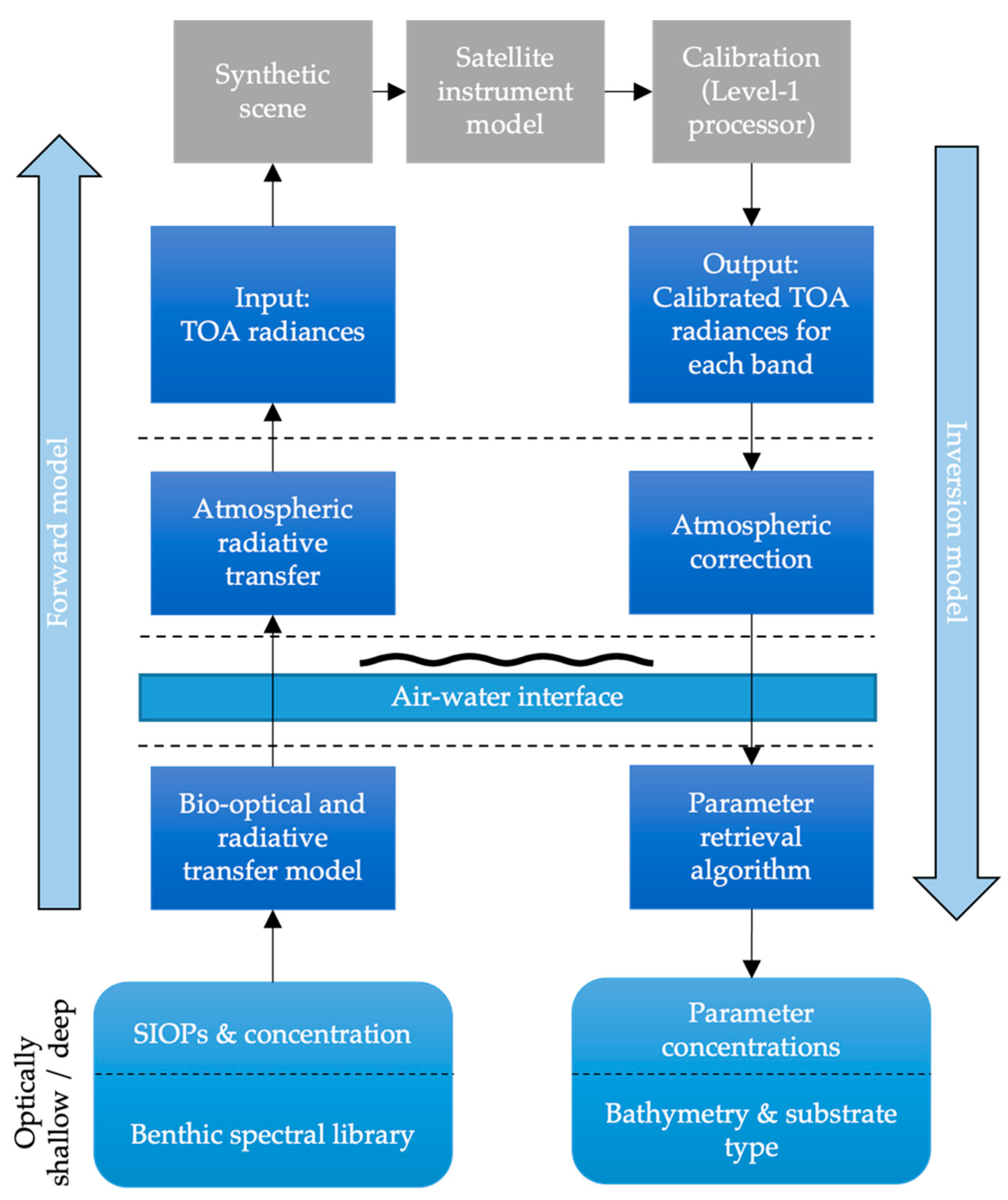
2.1. Simulator Description
2.1.1. Architecture and Scene Construction
2.1.2. Instrument Models and Calibration
2.2. Demonstration of the Simulator
2.2.1. Case Studies
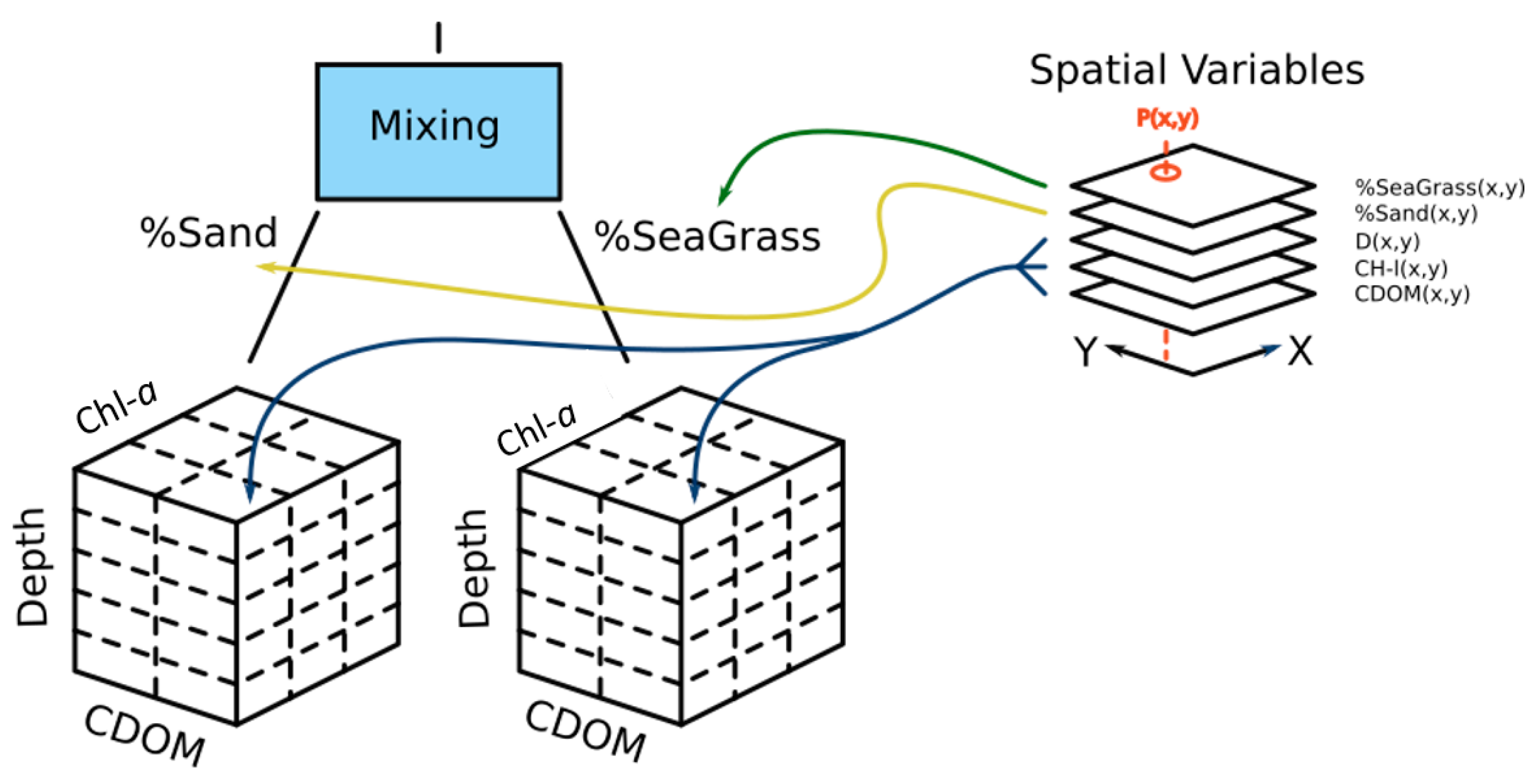
2.2.2. Input Datasets and Scene Generation
2.2.3. Hypothetical Satellite Instruments
- A “CubeSat” class instrument with a 60 mm, f#-2.75 telescope utilizing a small-pixel focal-plane array;
- A “SmallSat” class instrument with a 240 mm f#-1.80 telescope utilizing a large-pixel focal-plane array with an increased full-well capacity and gain.
2.2.4. Inversion and Validation
3. Results
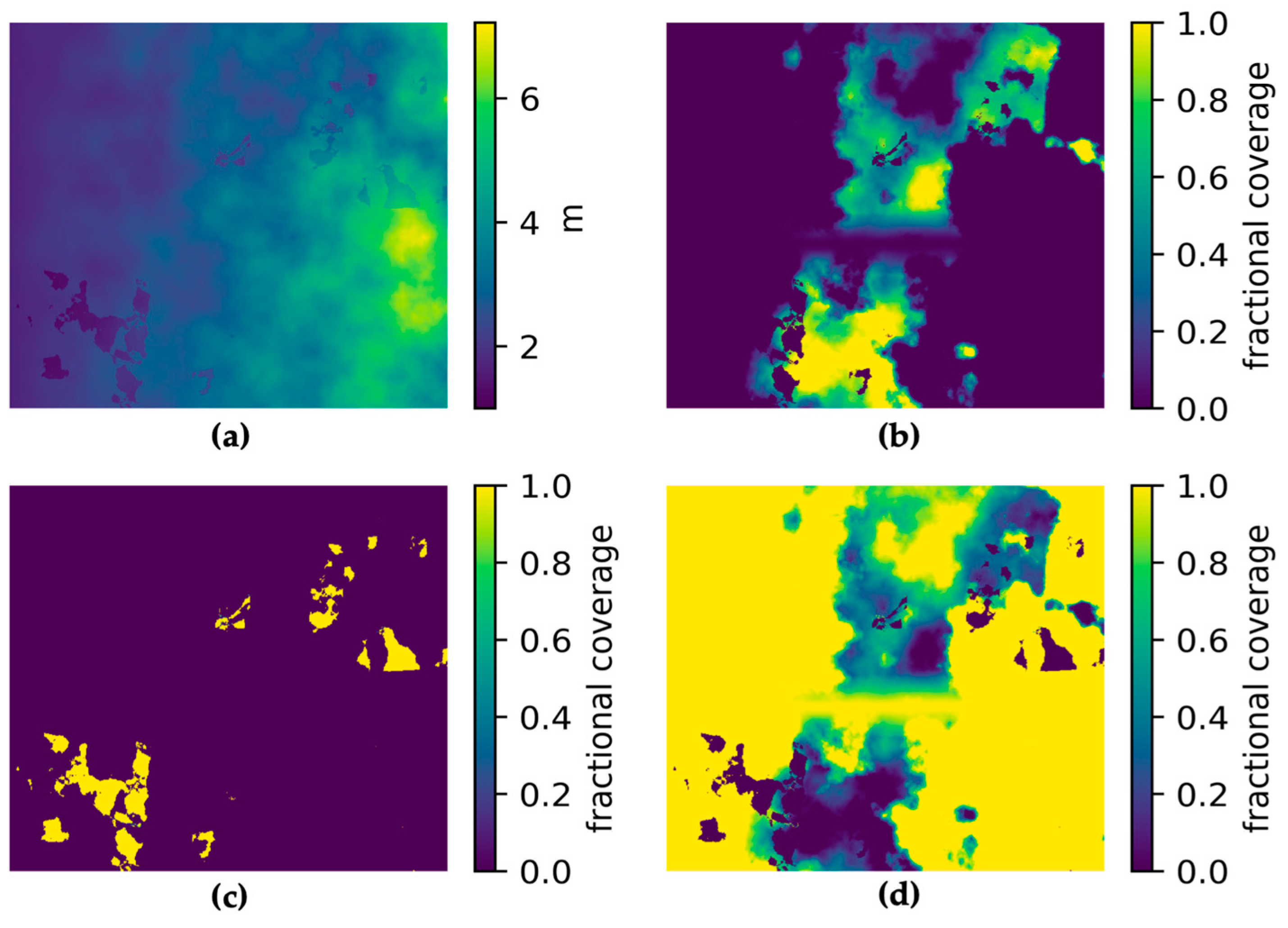
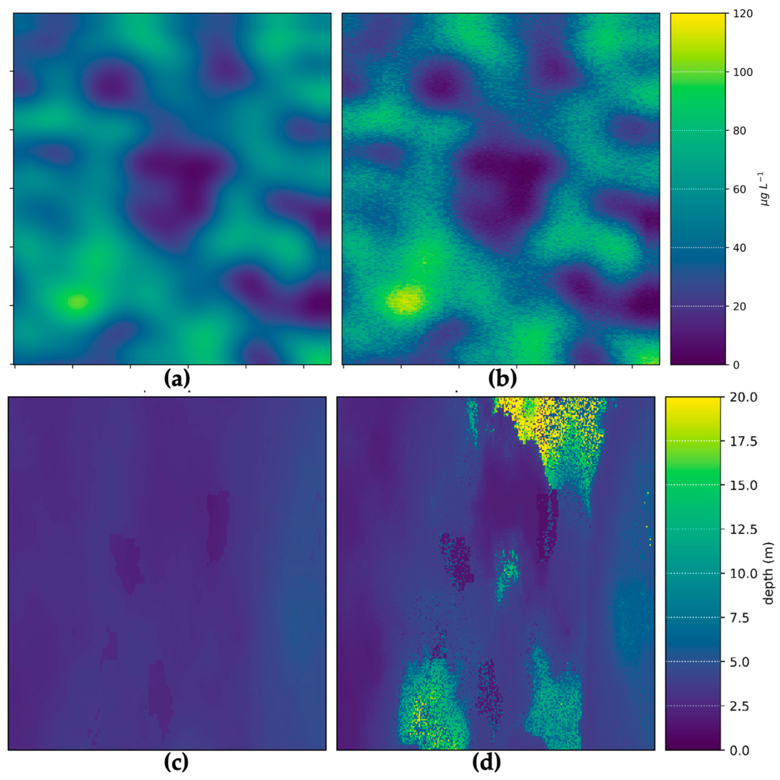
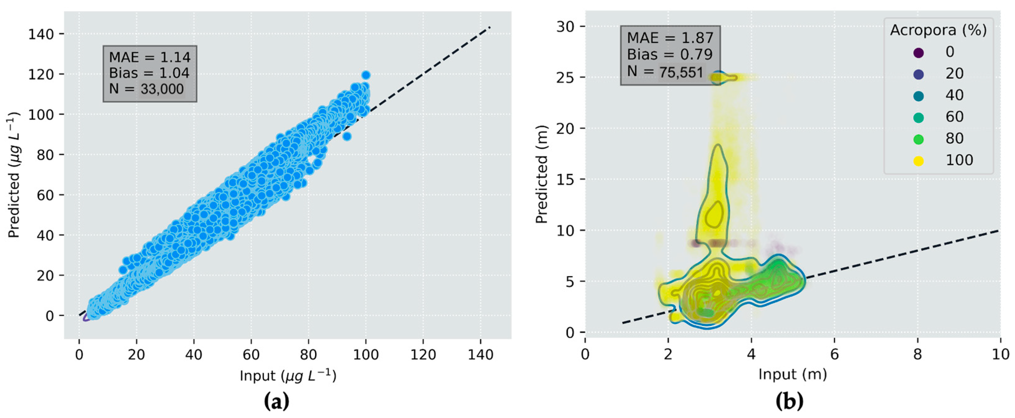
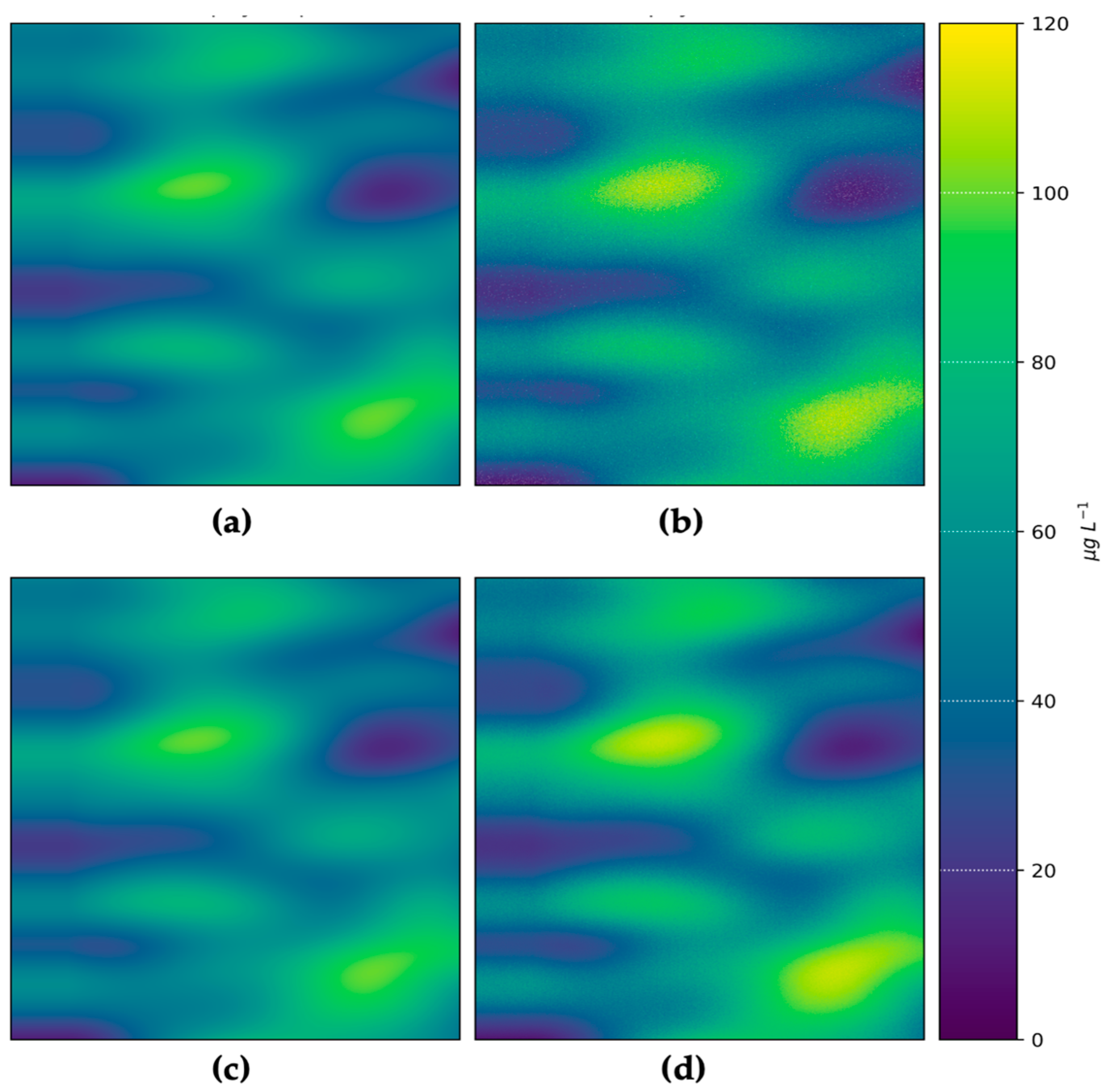
3.1. Water Depth and Chl-a Retrieval Applications
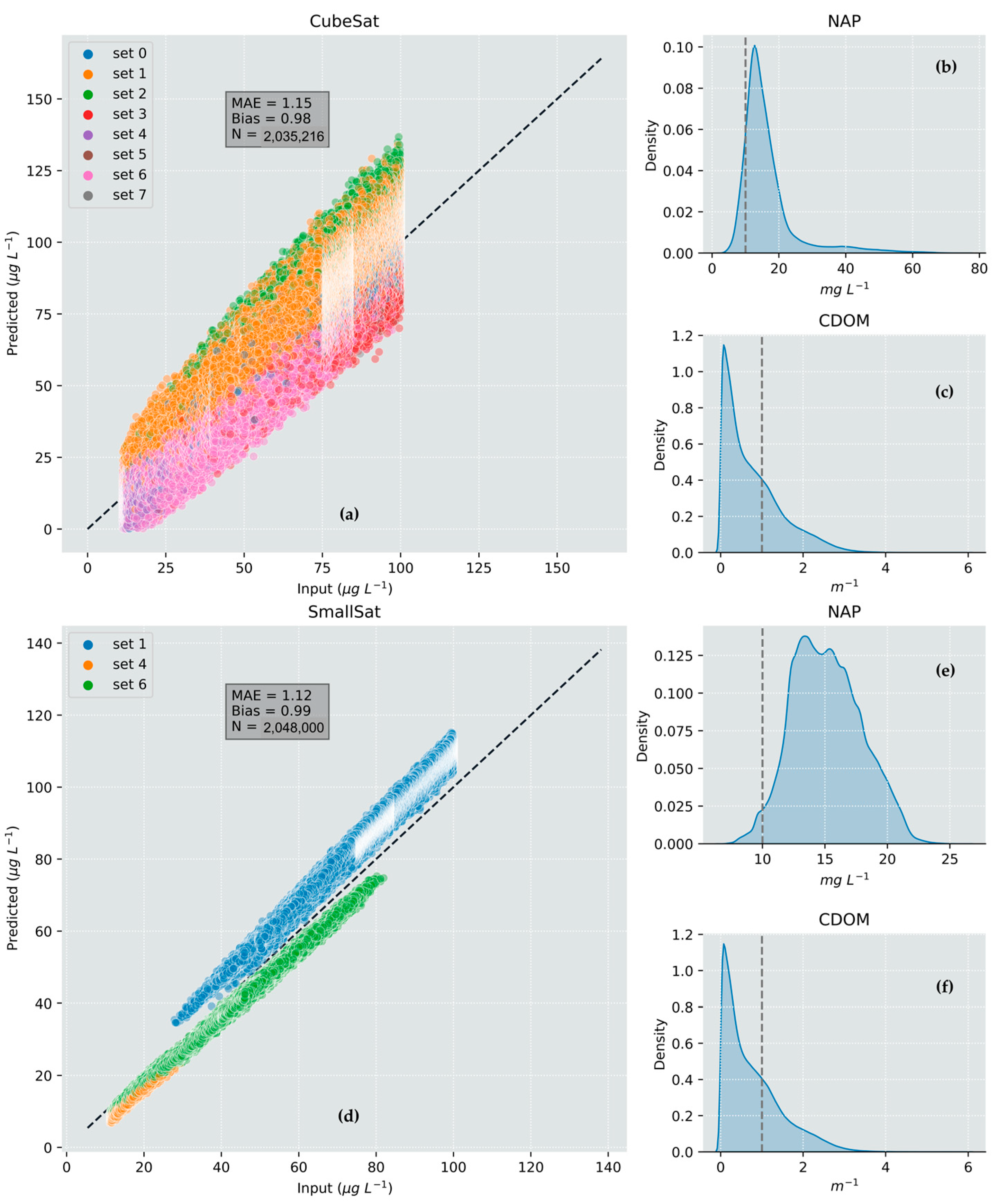
3.2. CubeSat versus SmallSat Trade-Off Demonstration
4. Discussion
Author Contributions
Funding
Institutional Review Board Statement
Informed Consent Statement
Data Availability Statement
Acknowledgments
Conflicts of Interest
Appendix A
- Twenty points in the scene were randomly sampled to obtain the sensor view angle (θ) and the sun-sensor azimuth difference (Φ).
- These values were then used to select the direction index and obtain water-leaving radiance (), surface irradiance (), , and upward atmospheric transmittance (). Note: obtained at this stage are the values that are input to the instrument model and are distinct from those output from the model.
- The path radiance () is then calculated as follows:
- The above equation is then rearranged to solve for (denoted ) and applied to the instrument model TOA radiance ():
- The remote sensing reflectance (), based on the water-leaving radiance normalized to the downwelling irradiance just above the water surface (), is then calculated as follows:
Appendix B

| Chl-a | 1, 30, 10, 30, 50, 100 µg/L | Horizontal visibility | 14 km |
| Non-algal particles | 10 mg/L | Relative humidity | 70% |
| aCDOM(440) | 1.0 m−1 | Cloud cover | 0% |
| Phytoplankton type | Cyanobacteria | Altitude | 0 m above sea level |
| NAP type | Generic | Gaseous absorption | Gas free atmosphere (not added) |
| Bathymetry | Optically deep | Date | 21 June |
| Vertical distribution | Homogeneous | Time | 11:00 a.m. |
| Phase function | Fournier-Forand | Sun zenith angle | 60° |
| Climatology | Cloud-free winter day | Spatial resolution | 1 pixel |
| Aerosol profile | Continental | Spectral resolution | 10 nm |
| Aerosol vertical profile | Standard profile | Polarization | Yes |
| Aerosol optical thickness at 550 nm | Measured mean | Angular resolution | 5° |
| Pressure | 1012 mb |
References
- SmartSat. Preliminary Concept Study for the Satellite Segment of AquaWatch Australia; SmartSat Aquawatch Technical Report no. 1; SmartSat: Adelaide, Australia, 2021. [Google Scholar]
- Committee on Earth Observation Satellites (CEOS). Feasibility Study for an Aquatic Ecosystem Earth Observing System; Dekker, A.G., Pinnel, N., Eds.; Commonwealth Scientific and Industrial Research Organisation: Canberra, Australia, 2018. [Google Scholar]
- Kerekes, J.P.; Landgrebe, D.A. Simulation of optical remote sensing systems. IEEE Trans. Geosci. Remote Sens. 1989, 27, 762–771. [Google Scholar] [CrossRef]
- Han, S.; Kerekes, J.P. Overview of Passive Optical Multispectral and Hyperspectral Image Simulation Techniques. IEEE J. Sel. Top. Appl. Earth Obs. Remote Sens. 2017, 10, 4794–4804. [Google Scholar] [CrossRef]
- Coppo, P.; Chiarantini, L.; Alparone, L. End-to-End Image Simulator for Optical Imaging Systems: Equations and Simulation Examples. Adv. Opt. Technol. 2013, 2013, 295950. [Google Scholar] [CrossRef]
- Verhoef, W.; Bach, H. Simulation of hyperspectral and directional radiance images using coupled biophysical and atmospheric radiative transfer models. Remote Sens. Environ. 2003, 87, 23–41. [Google Scholar] [CrossRef]
- Stratoulias, D.; Balzter, H.; Sykioti, O.; Zlinszky, A.; Tóth, V.R. Evaluating sentinel-2 for lakeshore habitat mapping based on airborne hyperspectral data. Sensors 2015, 15, 22956–22969. [Google Scholar] [CrossRef]
- Segl, K.; Guanter, L.; Rogass, C.; Kuester, T.; Roessner, S.; Kaufmann, H.; Sang, B.; Mogulsky, V.; Hofer, S. EeteS—The EnMAP end-to-end simulation tool. IEEE J. Sel. Top. Appl. Earth Obs. Remote Sens. 2012, 5, 522–530. [Google Scholar] [CrossRef]
- Vicent, J.; Sabater, N.; Tenjo, C.; Acarreta, J.R.; Manzano, M.; Rivera, J.P.; Jurado, P.; Franco, R.; Alonso, L.; Verrelst, J.; et al. FLEX end-to-end mission performance simulator. IEEE Trans. Geosci. Remote Sens. 2016, 54, 4215–4223. [Google Scholar] [CrossRef]
- Sgheri, L.; Belotti, C.; Ben-Yami, M.; Bianchini, G.; Carnicero Dominguez, B.; Cortesi, U.; Cossich, W.; Del Bianco, S.; Di Natale, G.; Guardabrazo, T.; et al. The FORUM end-to-end simulator project: Architecture and results. Atmos. Meas. Tech. 2022, 15, 573–604. [Google Scholar] [CrossRef]
- Guanter, L.; Segl, K.; Kaufmann, H. Simulation of Optical Remote-Sensing Scenes With Application to the EnMAP Hyperspectral Mission. IEEE Trans. Geosci. Remote Sens. 2009, 47, 2340–2351. [Google Scholar] [CrossRef]
- Verhoef, W.; Bach, H. Simulation of Sentinel-3 images by four-stream surface–atmosphere radiative transfer modeling in the optical and thermal domains. Remote Sens. Environ. 2012, 120, 197–207. [Google Scholar] [CrossRef]
- Gordon, H.R. Ocean color remote sensing systems: Radiometric requirements. In Proc. SPIE 0924, Recent Advances in Sensors, Radiometry, and Data Processing for Remote Sensing; SPIE: Bellingham, WA, USA, 1988; Volume 924, pp. 151–167. [Google Scholar]
- Wang, M.; Gordon, H.R. Sensor performance requirements for atmospheric correction of satellite ocean color remote sensing. Opt. Express 2018, 26, 7390–7403. [Google Scholar] [CrossRef] [PubMed]
- Grøtte, M.E.; Birkeland, R.; Honoré-Livermore, E.; Bakken, S.; Garrett, J.L.; Prentice, E.F.; Sigernes, F.; Orlandić, M.; Gravdahl, J.T.; Johansen, T.A. Ocean color hyperspectral remote sensing with high resolution and low latency—The HYPSO-1 CubeSat mission. IEEE Transact. Geosci. Remote Sens. 2021, 60, 1–19. [Google Scholar] [CrossRef]
- Rana, H.; Brewin, R.; Marais, E.; Hey, J.V.; Ghent, D.; Bird, R. A Passive Small Satellite Mission for Monitoring Ocean Health. IEEE Intl. Geosci. Remote Sens. Symp. 2022, 7351–7354. [Google Scholar]
- Morrison, J.M.; Jeffrey, H.; Gorter, H.; Anderson, P.; Clark, C.; Holmes, A.; Feldman, G.C.; Patt, F.S. SeaHawk: An advanced CubeSat mission for sustained ocean colour monitoring. In Proc. SPIE 10000, Sensors, Systems, and Next-Generation Satellites XX; SPIE: Bellingham, WA, USA, 2016; Volume 100001C, pp. 309–319. [Google Scholar]
- Matthews, M.W.; Kravitz, J.A.; Pease, J.; Gensemer, S. Determining the spectral requirements for cyanobacteria detection for the CyanoSat hyperspectral imager with machine learning. Sensors 2023, 23, 7800. [Google Scholar] [CrossRef]
- Drusch, M.; Del Bello, U.; Carlier, S.; Colin, O.; Fernandez, V.; Gascon, F.; Hoersch, B.; Isola, C.; Laberinti, P.; Martimort, P.; et al. Sentinel-2: ESA’s optical high-resolution mission for GMES operational services. Remote Sens. Environ. 2012, 120, 25–36. [Google Scholar] [CrossRef]
- Nieke, J.; Frerick, J.; Stroede, J.; Mavrocordatos, C.; Berruti, B. Status of the optical payload and processor development of ESA’s Sentinel 3 mission. IEEE Int. Geosci. Remote Sens. Symp. 2008, IV, 427–430. [Google Scholar]
- Oliver, R.L. Optical properties, of waters in the Murray-Darling Basin, South-eastern Australia. Mar. Freshw. Res. 1990, 41, 581–601. [Google Scholar] [CrossRef]
- Drayson, N.; Anstee, J.; Botha, H.; Kerrisk, G.; Ford, P.; Wojtasiewicz, B.; Clementson, L.; McLaughlin, J.; Hutton, M. Australian aquatic bio-optical dataset with applications for satellite calibration, algorithm development and validation. Data Br. 2022, 44, 108489. [Google Scholar] [CrossRef]
- Anstee, J.; Botha, H.; Cherukuru, N.; Clementson, L.; Oubelkheir, K.; Schroeder, T.; Blondeau-Patissier, D.; Ford, P.; Brando, V.; Dekker, A.G.; et al. Coastal Water Quality Laboratory and In Situ Measurements of SIOPs (Activity 2.1) and Substratum (Activity 2.2). v1; CSIRO: Canberra, Australia, 2020. [Google Scholar]
- Chami, M.; Lafrance, B.; Fougnie, B.; Chowdhary, J.; Harmel, T.; Waquet, F. OSOAA: A vector radiative transfer model of coupled atmosphere-ocean system for a rough sea surface application to the estimates of the directional variations of the water leaving reflectance to better process multi-angular satellite sensors data over the ocean. Opt. Exp. 2015, 23, 27829–27852. [Google Scholar]
- Shettle, E.P.; Fenn, R.W. Models for the Aerosols of the Lower Atmosphere and the Effects of Humidity Variations on Their Optical Properties (No. 676); Optical Physics Division, Air Force Geophysics Laboratory: Hanscomb AFB, MA, USA, 1979. [Google Scholar]
- Müller, S.; Schüler, L.; Zech, A.; Heße, F. GSTools v1.3: A toolbox for geostatistical modelling in Python. Geosci. Model Dev. 2022, 15, 3161–3182. [Google Scholar] [CrossRef]
- Brando, V.E.; Anstee, J.M.; Wettle, M.; Dekker, A.G.; Phinn, S.R.; Roelfsema, C. A physics based retrieval and quality assessment of bathymetry from suboptimal hyperspectral data. Remote Sens. Environ. 2009, 113, 755–770. [Google Scholar] [CrossRef]
- Brando, V.E.; Dekker, A.G.; Park, Y.J.; Schroeder, T. Adaptive semi-analytical inversion of ocean color radiometry in optically complex waters. Appl. Opt. 2012, 51, 2808–2833. [Google Scholar] [CrossRef] [PubMed]
- Seegers, B.N.; Stumpf, R.P.; Schaeffer, B.A.; Loftin, K.A.; Werdell, P.J. Performance metrics for the assessment of satellite data products: An ocean color case study. Opt. Exp. 2018, 26, 7404–7422. [Google Scholar] [CrossRef]
- Qi, J.; Xie, D.; Yin, T.; Yan, G.; Gastellu-Etchegorry, J.P.; Li, L.; Zhang, W.; Mu, X.; Norford, L.K. LESS: LargE-Scale remote sensing data and image simulation framework over heterogeneous 3D scenes. Remote Sens. Environ. 2019, 221, 695–706. [Google Scholar] [CrossRef]
- Lyu, Z.; Goossens, T.; Wandell, B.A.; Farrell, J. Validation of Physics-Based Image Systems Simulation With 3-D Scenes. IEEE Sens. J. 2022, 22, 19400–19410. [Google Scholar] [CrossRef]
- Auer, S.; Bamler, R.; Reinartz, P. RaySAR-3D SAR simulator: Now open source. IEEE Int. Geosci. Remote Sens. Symp. 2016, 6730–6733. [Google Scholar] [CrossRef]
- Matthews, M.W.; Bernard, S.; Evers-King, H.; Lain, L.R. Distinguishing cyanobacteria from algae in optically complex inland waters using a hyperspectral radiative transfer inversion algorithm. Remote Sens. Environ. 2020, 248, 111981. [Google Scholar] [CrossRef]


| Feature | Nominal | CubeSat | SmallSat | |
|---|---|---|---|---|
| Instrument geometry | Altitude (km) | 560 | 560 | 560 |
| Orbital heading azimuth | 0.0 | 0.0 | 0.0 | |
| Instrument Design | Polarimeter | None | None | None |
| Aperture size | 120 mm | 60 mm | 240 mm | |
| Pixel size | 5.5 µm | 5.86 µm | 15.5 µm | |
| Focal length | 165 mm | 165 mm | 432 mm | |
| Number of sensors | 1024 | 1024 | 1024 | |
| Exposure time | 0.0015 s | 0.0015 s | 0.0015 s | |
| Number of exposures | 1536 | 2000 | 2000 | |
| Forward tilt angle | 0 | 0 | 0 | |
| Read noise | 15.0 e | 15.0 e | 15.0 e | |
| Pixel well depth | 80,000 e | 80,000 e | 640,000 e | |
| Gain | 3.0 e/ADU | 3.0 e/ADU | 10 e/ADU | |
| Bias | 10.4 | 10.4 | 10.4 | |
| Bits | 16 | 16 | 16 | |
| Optical transmission | 0.885 | 0.885 | 0.885 | |
| Number of bands | 19 | 19 | 19 | |
| Centre wavelengths (nm) | 400, 411.8, 442.9, 490.5, 510.5, 560.5, 620.4, 665.3, 674, 681.6, 709.1, 754.2, 761.7, 764.8, 767.9, 779.2, 865.4, 884.3, 897.4 | |||
| Sampling resolution | 20 | |||
| Spectral response function | Sentinel 3A OLCI | |||
Disclaimer/Publisher’s Note: The statements, opinions and data contained in all publications are solely those of the individual author(s) and contributor(s) and not of MDPI and/or the editor(s). MDPI and/or the editor(s) disclaim responsibility for any injury to people or property resulting from any ideas, methods, instructions or products referred to in the content. |
© 2023 by the authors. Licensee MDPI, Basel, Switzerland. This article is an open access article distributed under the terms and conditions of the Creative Commons Attribution (CC BY) license (https://creativecommons.org/licenses/by/4.0/).
Share and Cite
Matthews, M.W.; Dekker, A.; Price, I.; Drayson, N.; Pease, J.; Antoine, D.; Anstee, J.; Sharp, R.; Woodgate, W.; Phinn, S.; et al. Demonstration of a Modular Prototype End-to-End Simulator for Aquatic Remote Sensing Applications. Sensors 2023, 23, 7824. https://doi.org/10.3390/s23187824
Matthews MW, Dekker A, Price I, Drayson N, Pease J, Antoine D, Anstee J, Sharp R, Woodgate W, Phinn S, et al. Demonstration of a Modular Prototype End-to-End Simulator for Aquatic Remote Sensing Applications. Sensors. 2023; 23(18):7824. https://doi.org/10.3390/s23187824
Chicago/Turabian StyleMatthews, Mark W., Arnold Dekker, Ian Price, Nathan Drayson, Joshua Pease, David Antoine, Janet Anstee, Robert Sharp, William Woodgate, Stuart Phinn, and et al. 2023. "Demonstration of a Modular Prototype End-to-End Simulator for Aquatic Remote Sensing Applications" Sensors 23, no. 18: 7824. https://doi.org/10.3390/s23187824
APA StyleMatthews, M. W., Dekker, A., Price, I., Drayson, N., Pease, J., Antoine, D., Anstee, J., Sharp, R., Woodgate, W., Phinn, S., & Gensemer, S. (2023). Demonstration of a Modular Prototype End-to-End Simulator for Aquatic Remote Sensing Applications. Sensors, 23(18), 7824. https://doi.org/10.3390/s23187824