
Geocorrection of Airborne Mid-Wave Infrared Imagery for Mapping Wildfires without GPS or IMU

 , , ,
, , , 
Abstract
1. Introduction
2. Data Collection
2.1. Field Campaign
2.2. FLIR Sensor
2.3. Twin Otter Survey Aircraft Hardware
3. Methods
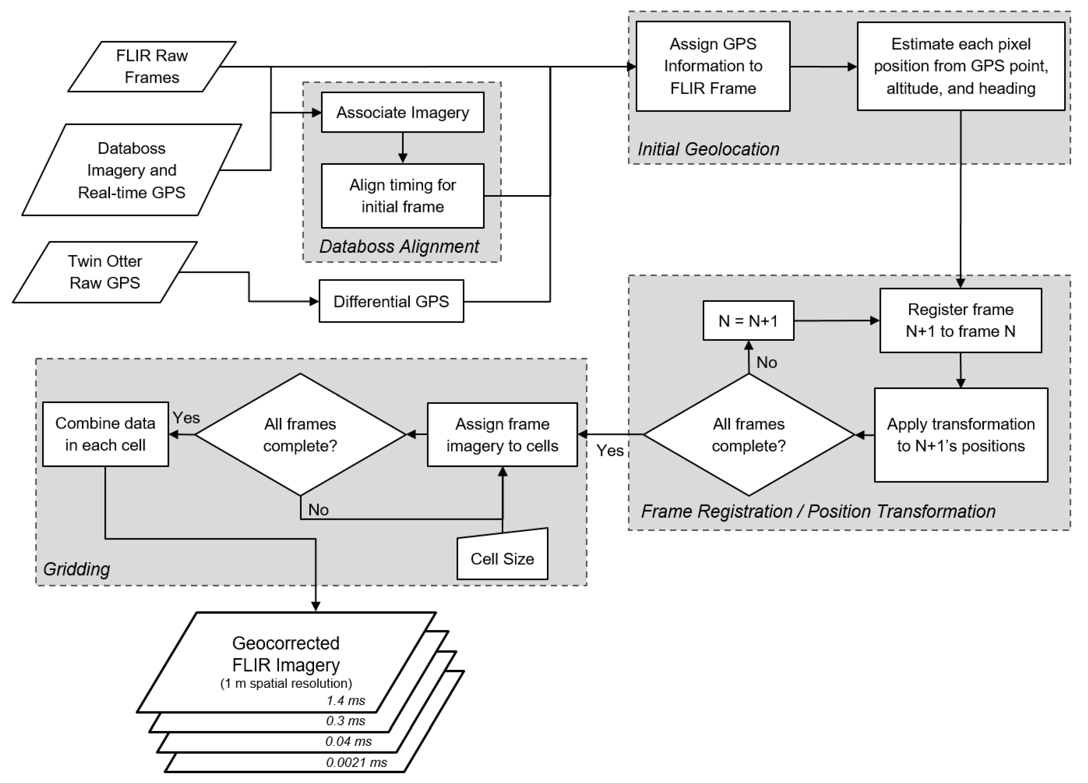
3.1. Geocorrection Process
3.1.1. Initial Imagery Setup and Databoss Alignment
3.1.2. Initial Geolocation
3.1.3. Frame Registration
3.1.4. Gridding
3.2. Georeferencing Process
3.3. Data Products
4. Results
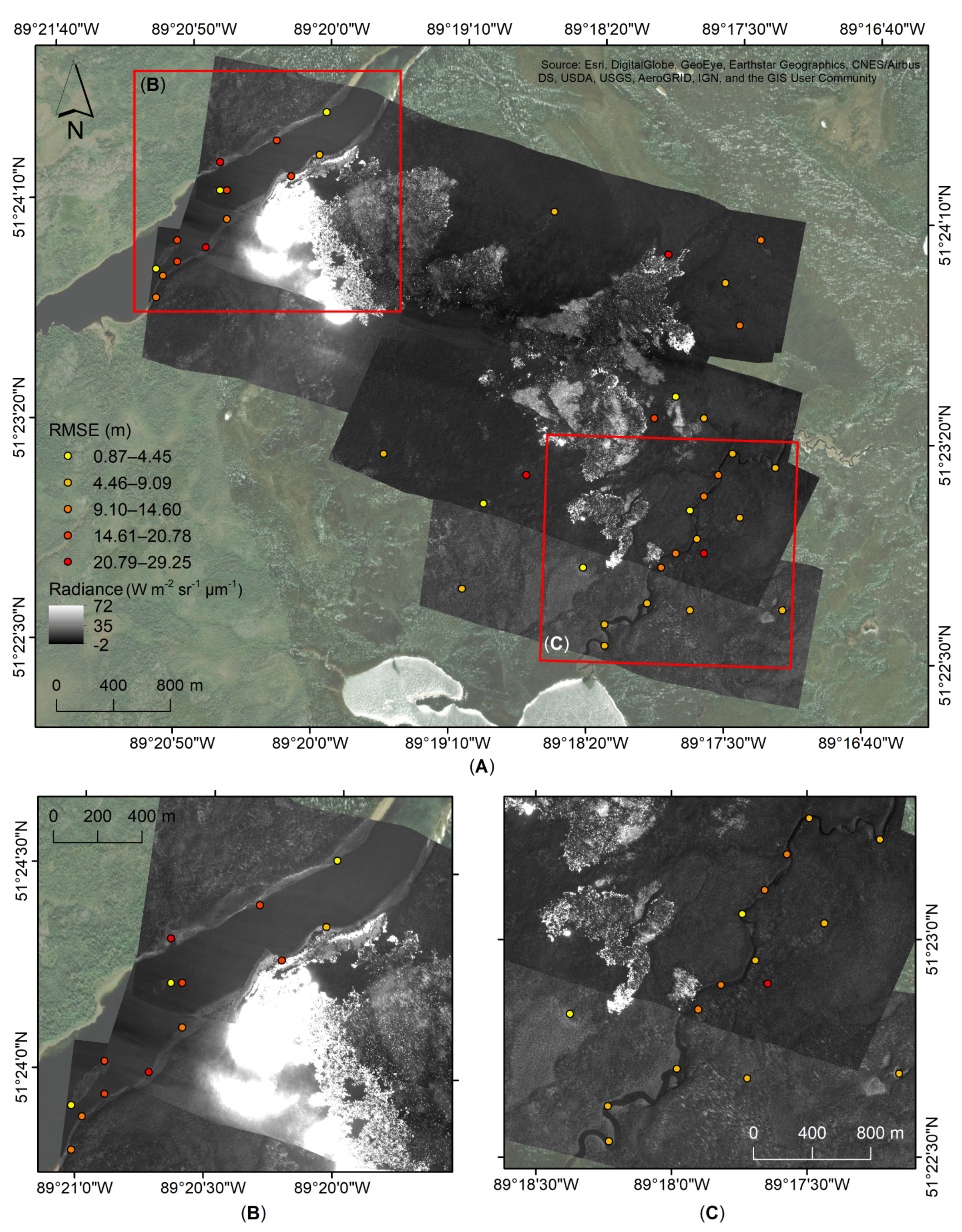
4.1. Geocorrection Assessment
4.2. Georeferencing Assessment
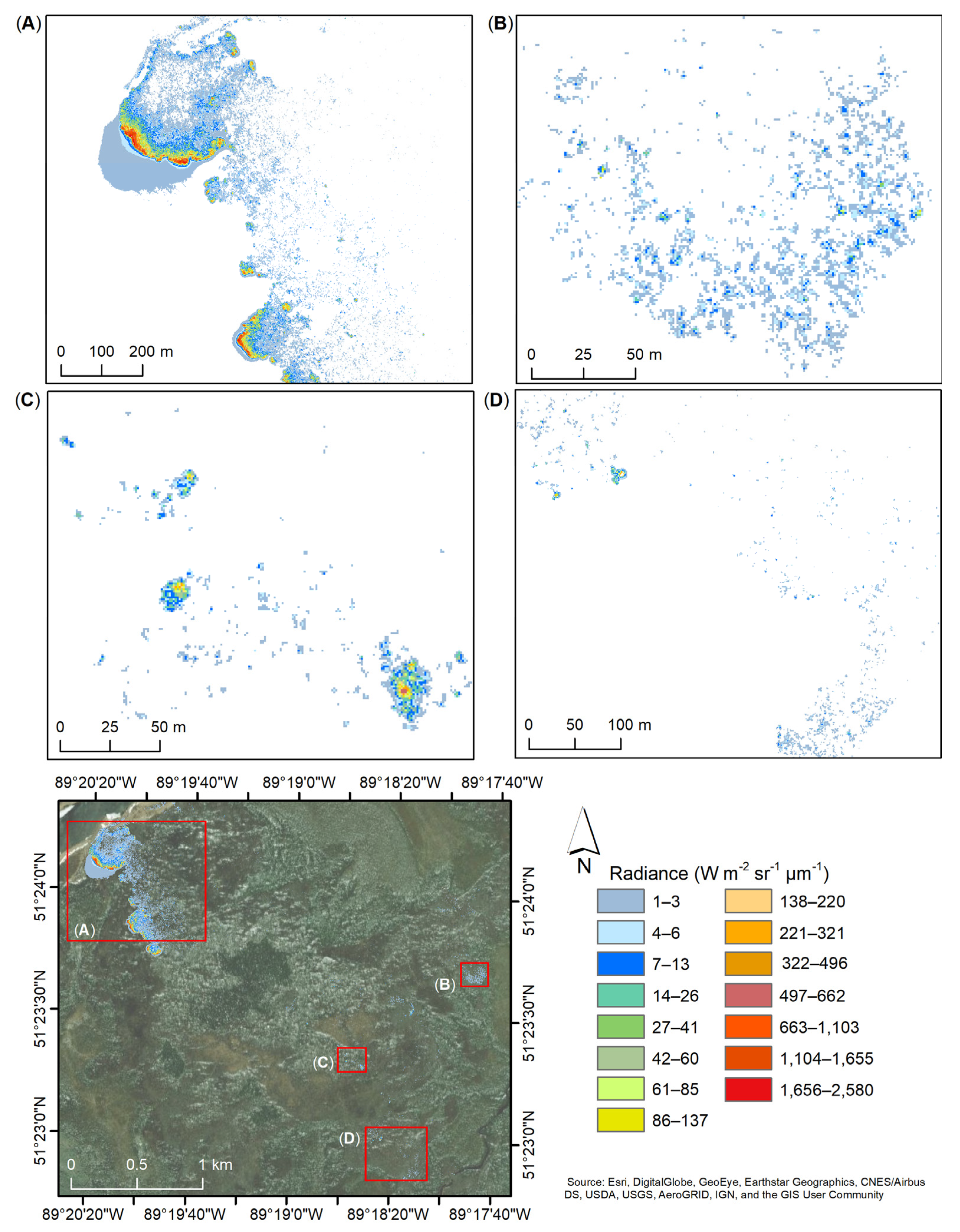
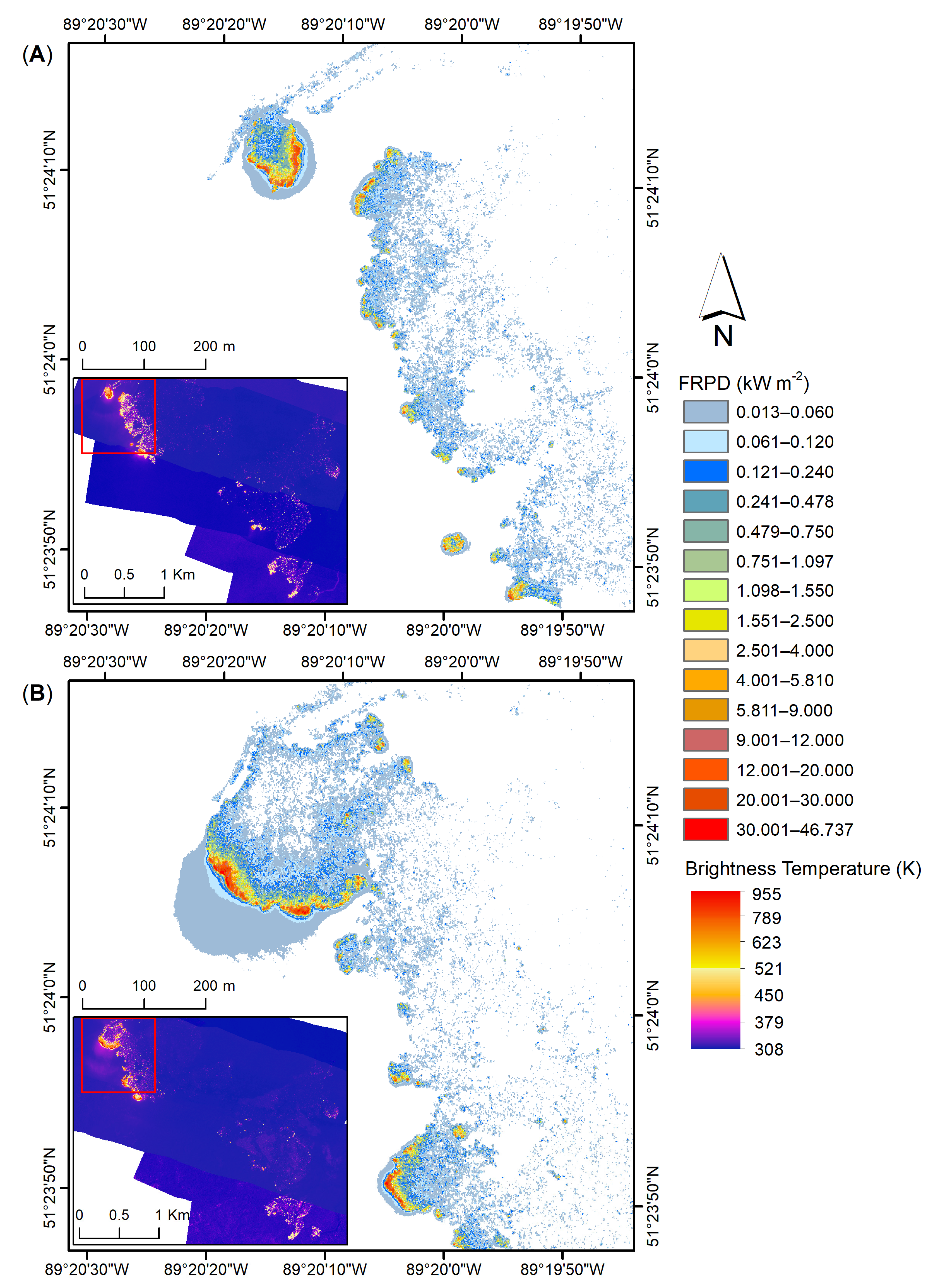
4.3. Data Products
5. Discussion
6. Conclusions
Author Contributions
Funding
Institutional Review Board Statement
Informed Consent Statement
Data Availability Statement
Acknowledgments
Conflicts of Interest
References
- Doerr, S.H.; Santín, C. Global trends in wildfire and its impacts: Perceptions versus realities in a changing world. Philos. Trans. R. Soc. Lond. B Biol. Sci. 2016, 371, 20150345. [Google Scholar] [CrossRef] [PubMed]
- Coogan, S.C.P.; Robinne, F.-N.; Jain, P.; Flannigan, M.D. Scientists’ warning on wildfire—A Canadian perspective. Can. J. For. Res. 2019, 49, 1015–1023. [Google Scholar] [CrossRef]
- Flannigan, M.D.; Krawchuk, M.A.; de Groot, W.J.; Wotton, B.M.; Gowman, L.M. Implications of changing climate for global wildland fire. Int. J. Wildland Fire 2009, 18, 483–507. [Google Scholar] [CrossRef]
- O’Neill, S.J.; Handmer, J. Responding to bushfire risk: The need for transformative adaptation. Environ. Res. Lett. 2012, 7, 014018. [Google Scholar] [CrossRef]
- Johnston, L.M.; Wang, X.; Erni, S.; Taylor, S.W.; McFayden, C.B.; Oliver, J.A.; Stockdale, C.; Christianson, A.; Boulanger, Y.; Gauthier, S.; et al. Wildland fire risk research in Canada. Environ. Rev. 2020, 28, 164–186. [Google Scholar] [CrossRef]
- Baldwin, C.; Ross, H. Beyond a tragic fire season: A window of opportunity to address climate change? Australas. J. Environ. Manag. 2020, 27, 1–5. [Google Scholar] [CrossRef]
- Schoennagel, T.; Nelson, C.R.; Theobald, D.M.; Carnwath, G.C.; Chapman, T.B. Implementation of National Fire Plan treatments near the wildland-urban interface in the western United States. Proc. Natl. Acad. Sci. USA 2009, 106, 10706–10711. [Google Scholar] [CrossRef]
- Schroeder, W.; Oliva, P.; Giglio, L.; Csiszar, I.A. The New VIIRS 375m active fire detection data product: Algorithm description and initial assessment. Remote Sens. Environ. 2014, 143, 85–96. [Google Scholar] [CrossRef]
- Paugam, R.; Wooster, M.J.; Roberts, G. Use of Handheld Thermal Imager Data for Airborne Mapping of Fire Radiative Power and Energy and Flame Front Rate of Spread. IEEE Trans. Geosci. Remote Sens. 2013, 51, 3385–3399. [Google Scholar] [CrossRef]
- Radke, L.F.; Clark, T.L.; Coen, J.L.; Walther, C.A.; Lockwood, R.N.; Riggan, P.J.; Brass, J.A.; Higgins, R.G. The WildFire Experiment (WiFE): Observations with Airborne Remote Sensors. Can. J. Remote Sens. 2000, 26, 406–417. [Google Scholar] [CrossRef]
- Wooster, M.J.; Roberts, G.; Perry, G.L.W.; Kaufman, Y.J. Retrieval of biomass combustion rates and totals from fire radiative power observations: FRP derivation and calibration relationships between biomass consumption and fire radiative energy release. J. Geophys. Res. Atmos. 2005, 110. [Google Scholar] [CrossRef]
- Wooster, M.J.; Xu, W.; Nightingale, T. Sentinel-3 SLSTR active fire detection and FRP product: Pre-launch algorithm development and performance evaluation using MODIS and ASTER datasets. Remote Sens. Environ. 2012, 120, 236–254. [Google Scholar] [CrossRef]
- Johnston, J.M.; Jackson, N.; McFayden, C.; Ngo Phong, L.; Lawrence, B.; Davignon, D.; Wooster, M.J.; van Mierlo, H.; Thompson, D.K.; Cantin, A.S.; et al. Development of the User Requirements for the Canadian WildFireSat Satellite Mission. Sensors 2020, 20, 5081. [Google Scholar] [CrossRef]
- Davis, K.T.; Dobrowski, S.Z.; Higuera, P.E.; Holden, Z.A.; Veblen, T.T.; Rother, M.T.; Parks, S.A.; Sala, A.; Maneta, M.P. Wildfires and climate change push low-elevation forests across a critical climate threshold for tree regeneration. Proc. Natl. Acad. Sci. USA 2019, 116, 6193–6198. [Google Scholar] [CrossRef]
- Williams, A.P.; Abatzoglou, J.T.; Gershunov, A.; Guzman-Morales, J.; Bishop, D.A.; Balch, J.K.; Lettenmaier, D.P. Observed Impacts of Anthropogenic Climate Change on Wildfire in California. Earth′s Future 2019, 7, 892–910. [Google Scholar] [CrossRef]
- Goss, M.; Swain, D.L.; Abatzoglou, J.T.; Sarhadi, A.; Kolden, C.A.; Williams, A.P.; Diffenbaugh, N.S. Climate change is increasing the likelihood of extreme autumn wildfire conditions across California. Environ. Res. Lett. 2020, 15, 094016. [Google Scholar] [CrossRef]
- Allison, R.; Johnston, J.; Craig, G.; Jennings, S. Airborne optical and thermal remote sensing for wildfire detection and monitoring. Sensors 2016, 16, 1310. [Google Scholar] [CrossRef] [PubMed]
- Giglio, L.; Csiszar, I.; Restás, Á.; Morisette, J.T.; Schroeder, W.; Morton, D.; Justice, C.O. Active fire detection and characterization with the advanced spaceborne thermal emission and reflection radiometer (ASTER). Remote Sens. Environ. 2008, 112, 3055–3063. [Google Scholar] [CrossRef]
- Yuan, C.; Zhang, Y.; Liu, Z. A survey on technologies for automatic forest fire monitoring, detection, and fighting using unmanned aerial vehicles and remote sensing techniques. Can. J. For. Res. 2015, 45, 783–792. [Google Scholar] [CrossRef]
- Castillo, M.; Plaza, Á.; Garfias, R. A recent review of fire behavior and fire effects on native vegetation in Central Chile. Glob. Ecol. Conserv. 2020, 24, e01210. [Google Scholar] [CrossRef]
- Ottmar, R.D. Wildland fire emissions, carbon, and climate: Modeling fuel consumption. For. Ecol. Manag. 2014, 317, 41–50. [Google Scholar] [CrossRef]
- Bento-Gonçalves, A.; Vieira, A. Wildfires in the wildland-urban interface: Key concepts and evaluation methodologies. Sci. Total Environ. 2020, 707, 135592. [Google Scholar] [CrossRef] [PubMed]
- Dickinson, M.B.; Hudak, A.T.; Zajkowski, T.; Loudermilk, E.L.; Schroeder, W.; Ellison, L.; Kremens, R.L.; Holley, W.; Martinez, O.; Paxton, A.; et al. Measuring radiant emissions from entire prescribed fires with ground, airborne and satellite sensors–RxCADRE 2012. Int. J. Wildland Fire 2016, 25, 48–61. [Google Scholar] [CrossRef]
- Stow, D.; Riggan, P.; Schag, G.; Brewer, W.; Tissell, R.; Coen, J.; Storey, E. Assessing uncertainty and demonstrating potential for estimating fire rate of spread at landscape scales based on time sequential airborne thermal infrared imaging. Int. J. Remote Sens. 2019, 40, 4876–4897. [Google Scholar] [CrossRef]
- He, X.; Yang, X.; Luo, Z.; Guan, T. Application of unmanned aerial vehicle (UAV) thermal infrared remote sensing to identify coal fires in the Huojitu coal mine in Shenmu city, China. Sci. Rep. 2020, 10, 13895. [Google Scholar] [CrossRef]
- Ciullo, V.; Rossi, L.; Pieri, A. Experimental Fire Measurement with UAV Multimodal Stereovision. Remote Sens. 2020, 12, 3546. [Google Scholar] [CrossRef]
- Freeborn, P.H.; Wooster, M.J.; Roy, D.P.; Cochrane, M.A. Quantification of MODIS fire radiative power (FRP) measurement uncertainty for use in satellite-based active fire characterization and biomass burning estimation. Geophys. Res. Lett. 2014, 41, 1988–1994. [Google Scholar] [CrossRef]
- Wan, Z.; Zhang, Y.; Ma, X.; King, M.D.; Myers, J.S.; Li, X. Vicarious calibration of the Moderate-Resolution Imaging Spectroradiometer Airborne Simulator thermal-infrared channels. Appl. Opt. 1999, 38, 6294–6306. [Google Scholar] [CrossRef]
- Hall, J.V.; Zhang, R.; Schroeder, W.; Huang, C.; Giglio, L. Validation of GOES-16 ABI and MSG SEVIRI active fire products. Int. J. Appl. Earth Obs. Geoinf. 2019, 83, 101928. [Google Scholar] [CrossRef]
- Johnston, J.M.; Wheatley, M.J.; Wooster, M.J.; Paugam, R.; Davies, G.M.; DeBoer, K.A. Flame-Front Rate of Spread Estimates for Moderate Scale Experimental Fires Are Strongly Influenced by Measurement Approach. Fire 2018, 1, 16. [Google Scholar] [CrossRef]
- Johnston, J.M.; Wooster, M.J.; Paugam, R.; Wang, X.; Lynham, T.J.; Johnston, L.M. Direct estimation of Byram’s fire intensity from infrared remote sensing imagery. Int. J. Wildland Fire 2017, 26, 668–684. [Google Scholar] [CrossRef]
- Müller, R.; Lehner, M.; Müller, R.; Reinartz, P.; Schroeder, M.; Vollmer, B. A program for direct georeferencing of airborne and spaceborne line scanner images. Int. Arch. Photogramm. Remote Sens. Spat. Inf. Sci. 2002, 34, 148–153. [Google Scholar]
- Stow, D.A.; Riggan, P.J.; Storey, E.J.; Coulter, L.L. Measuring fire spread rates from repeat pass airborne thermal infrared imagery. Remote Sens. Lett. 2014, 5, 803–812. [Google Scholar] [CrossRef]
- Kalacska, M.; Lucanus, O.; Arroyo-Mora, J.P.; Laliberté, É.; Elmer, K.; Leblanc, G.; Groves, A. Accuracy of 3D Landscape Reconstruction without Ground Control Points Using Different UAS Platforms. Drones 2020, 4, 13. [Google Scholar] [CrossRef]
- Wotton, B.M.; Gould, J.S.; McCaw, W.L.; Cheney, N.P.; Taylor, S.W. Flame temperature and residence time of fires in dry eucalypt forest. Int. J. Wildland Fire 2012, 21, 270–281. [Google Scholar] [CrossRef]
- Lee, M.; Ifimov, G.; Naprstek, T.; Arroyo-Mora, J.P.; Craig, G.; Leblanc, G. Canadian Wildland Fire Momitoring System (CWFMS): Calibration, Pre-Processing and Georeferencing of MWIR Airborne Data; LTR-FRL-2019-0114; National Research Council: Ottawa, ON, Canada, 2019. [Google Scholar]
- Paul, G. Principles of GNSS, Inertial, and Multisensor Integrated Navigation Systems, 2nd ed.; Artech: Norwood, MA, USA, 2013. [Google Scholar]
- Naprstek, T.; Arroyo-Mora, J.P.; Johnston, J.; Leblanc, G. ReSVA: A MATLAB method to co-register and mosaic airborne video-based remotely sensed data. Methods X Under Rev. 2021. [Google Scholar]
- Berk, A.; Conforti, P.; Kennett, R.; Perkins, T.; Hawes, F.; Van Den Bosch, J. MODTRAN® 6: A major upgrade of the MODTRAN® radiative transfer code. In Proceedings of the 2014 6th Workshop on Hyperspectral Image and Signal Processing: Evolution in Remote Sensing (WHISPERS), Lausanne, Switzerland, 24–27 June 2014; pp. 1–4. [Google Scholar]
- Ji, Y.; Xu, W.; Li, Y.; Ma, D. Research on the measurement of mid-wavelength infrared average atmospheric characteristics. In Proceedings of the 2013 2nd International Conference on Measurement, Information and Control, Harbin, China, 16–18 August 2013; pp. 115–118. [Google Scholar]
- Warren, M.A.; Taylor, B.H.; Grant, M.G.; Shutler, J.D. Data processing of remotely sensed airborne hyperspectral data using the Airborne Processing Library (APL): Geocorrection algorithm descriptions and spatial accuracy assessment. Comput. Geosci. 2014, 64, 24–34. [Google Scholar] [CrossRef]
- Coulter, L.L.; Stow, D.A.; Baer, S. A frame center matching technique for precise registration of multitemporal airborne frame imagery. IEEE Trans. Geosci. Remote Sens. 2003, 41, 2436–2444. [Google Scholar] [CrossRef]
- Coulter, L.L.; Stow, D.A. Assessment of the Spatial Co-registration of Multitemporal Imagery from Large Format Digital Cameras in the Context of Detailed Change Detection. Sensors 2008, 8, 2161–2173. [Google Scholar] [CrossRef] [PubMed]
- Aguilar, M.A.; Aguilar, F.J.; Mar Saldaña, M.d.; Fernández, I. Geopositioning Accuracy Assessment of GeoEye-1 Panchromatic and Multispectral Imagery. Photogramm. Eng. Remote Sens. 2012, 78, 247–257. [Google Scholar] [CrossRef]
- Wooster, M.J.; Roberts, G.; Smith, A.M.S.; Johnston, J.; Freeborn, P.; Amici, S.; Hudak, A.T. Thermal Remote Sensing of Active Vegetation Fires and Biomass Burning Events. In Thermal Infrared Remote Sensing: Sensors, Methods, Applications; Kuenzer, C., Dech, S., Eds.; Springer: Dordrecht, The Netherlands, 2013; pp. 347–390. [Google Scholar] [CrossRef]
- ESA; EUMETSAT. Sentinel-3 Mission Status: 7 September 2017. Available online: https://sentinel.esa.int/documents/247904/2802412/Sentinel-3-Mission-Status-Report-36-07-sep-2017.pdf (accessed on 19 April 2021).
- Penney, G.; Richardson, S. Modelling of the Radiant Heat Flux and Rate of Spread of Wildfire within the Urban Environment. Fire 2019, 2, 4. [Google Scholar] [CrossRef]


| Flt No. | Date | Time Period | No. of Lines | Start Time (EST) | End Time (EST) | Altitude (m MSL) | Ground Speed (Knots) |
|---|---|---|---|---|---|---|---|
| F-03 | August 2 a | Night | 16 b | 22:20 | 23:37 | 2888.2 | 92.5 |
| F-04 | August 3 | Day | 16 b | 10:26 | 11:41 | 2915.1 | 93.9 |
| Characteristic | Value |
|---|---|
| Spectral Range (µm) | 3.0–5.0 |
| Detector Pitch (µm) | 14 |
| Frame Rate (Hz) | Up to 125 |
| Resolution (pixels) | 1344 × 784 |
| Temperature Accuracy | ±2 or 2% |
| Standard Temperature Range (°C) | −20 to +350 |
| Operating Temperature Range (°C) | −40 to 50 |
| Weight without lens (kg) | 4.5 |
| Variable | Raw, All Frames | Geocorrected, Gridded | Change (%) |
|---|---|---|---|
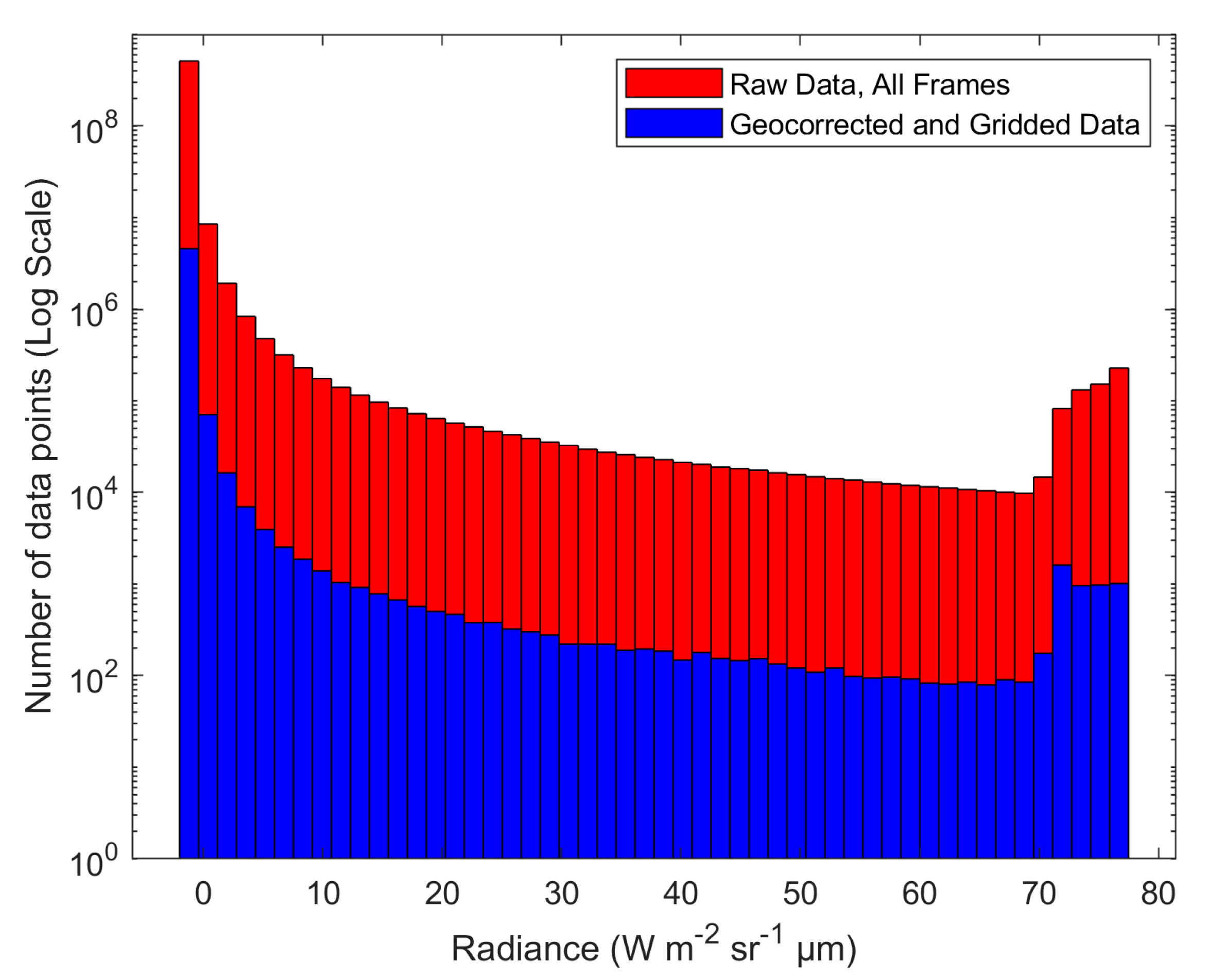
| Total Data Points | 527,901,696 | 4,701,690 | 99.11 |
| Mean | −1.18 | −1.20 | 1.70 |
| Median | −1.44 | −1.44 | 0.00 |
| Standard Deviation | 3.08 | 2.86 | 7.14 |
| Minimum | −1.66 | −1.64 | 1.21 |
| Maximum | 77.39 | 77.05 | 0.44 |
| Skewness | 21.18 | 22.50 | 6.23 |
| Kurtosis | 489.75 | 553.33 | 12.98 |
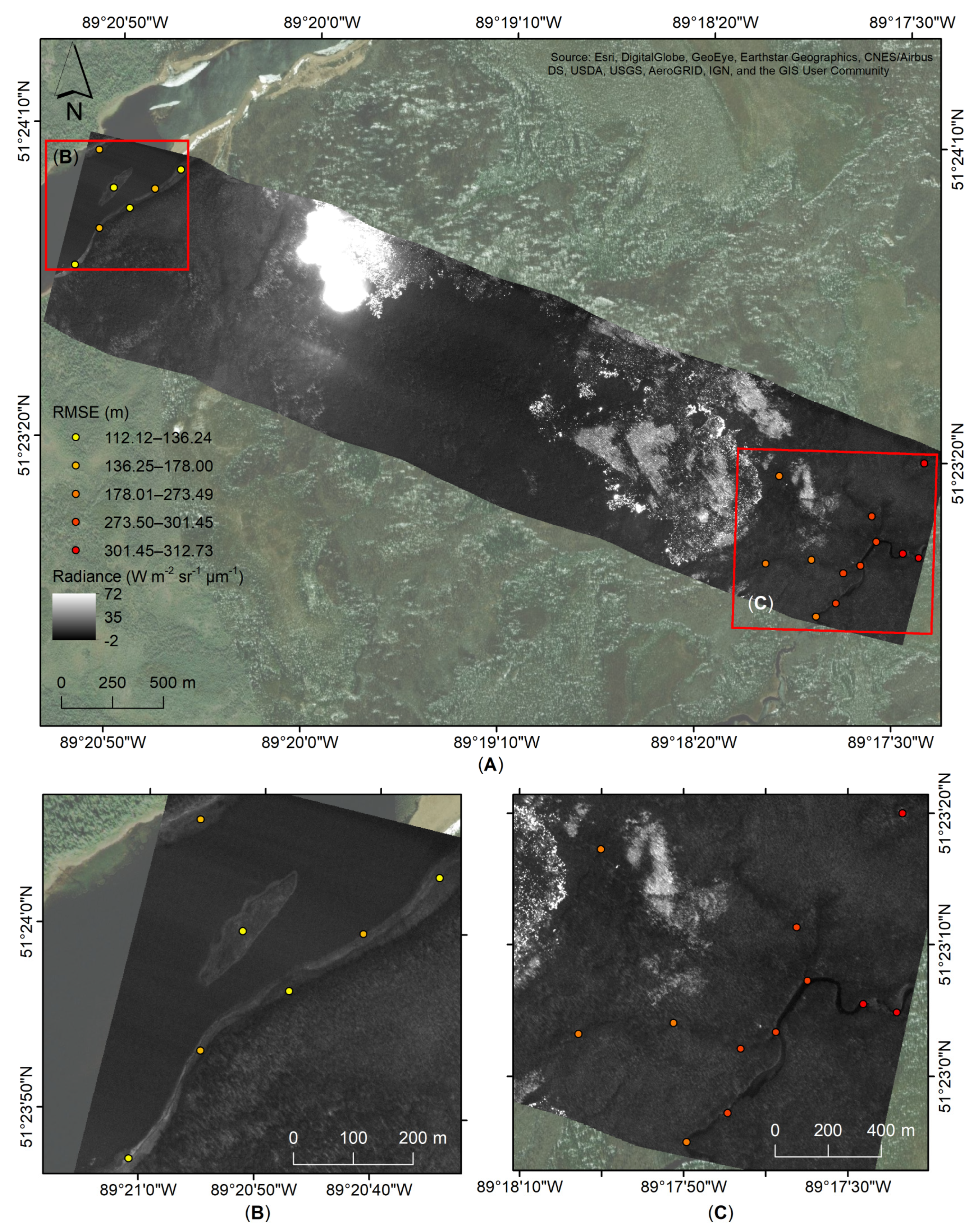
| Variable | Abs. Easting (m) | Abs. Northing (m) | Total RMSE (m) |
|---|---|---|---|
| Mean | 6.96 | 8.66 | 11.90 |
| Minimum | 0.30 | 0.25 | 0.87 |
| Maximum | 24.13 | 25.43 | 29.25 |
| Median | 5.30 | 7.46 | 10.75 |
| Standard deviation | 5.21 | 6.65 | 7.26 |
| Variable | Abs. Easting (m) | Abs. Northing (m) | Total RMSE (m) |
|---|---|---|---|
| Mean | 2.38 | 2.53 | 3.86 |
| Minimum | 0.01 | 0.04 | 0.17 |
| Maximum | 9.42 | 13.17 | 14.28 |
| Median | 2.02 | 1.55 | 3.21 |
| Standard deviation | 1.96 | 2.76 | 2.92 |
| Flight Line | Night Flight (August 2) | Day Flight (August 3) | |||
|---|---|---|---|---|---|
| IT (ms) | PGCPs | RMSE (m) | PGCPs | RMSE (m) | |
| FL-02 | 1.4 | 9 | 10.85 | 10 | 8.83 |
| 0.3 | 9 | 8.73 | 10 | 8.83 | |
| 0.04 | 9 | 9.67 | 9 | 9.71 | |
| FL-03 | 1.4 | 9 | 16.22 | 9 | 14.28 |
| 0.3 | 10 | 14.54 | 9 | 14.28 | |
| 0.04 | 10 | 14.54 | 9 | 14.93 | |
| FL-04 | 1.4 | 9 | 17.32 | 13 | 11.76 |
| 0.3 | 10 | 12.46 | 13 | 11.76 | |
| 0.04 | 9 | 13.36 | 12 | 12.58 | |
| 0.0021 | 9 | 13.36 | 12 | 12.39 | |
| FL-05 | 1.4 | 9 | 24.50 | 10 | 16.65 |
| 0.3 | 10 | 16.99 | 10 | 16.65 | |
| 0.04 | 9 | 18.21 | 12 | 17.44 | |
| 0.0021 | 9 | 18.21 | 12 | 17.33 | |
| FL-06 | 1.4 | 10 | 17.33 | 10 | 13.84 |
| 0.3 | 10 | 14.57 | 10 | 13.84 | |
| 0.04 | 9 | 15.58 | 12 | 14.64 | |
| 0.0021 | 9 | 15.58 | 12 | 14.62 | |
Publisher’s Note: MDPI stays neutral with regard to jurisdictional claims in published maps and institutional affiliations. |
© 2021 by the authors. Licensee MDPI, Basel, Switzerland. This article is an open access article distributed under the terms and conditions of the Creative Commons Attribution (CC BY) license (https://creativecommons.org/licenses/by/4.0/).
Share and Cite
Ifimov, G.; Naprstek, T.; Johnston, J.M.; Arroyo-Mora, J.P.; Leblanc, G.; Lee, M.D. Geocorrection of Airborne Mid-Wave Infrared Imagery for Mapping Wildfires without GPS or IMU. Sensors 2021, 21, 3047. https://doi.org/10.3390/s21093047
Ifimov G, Naprstek T, Johnston JM, Arroyo-Mora JP, Leblanc G, Lee MD. Geocorrection of Airborne Mid-Wave Infrared Imagery for Mapping Wildfires without GPS or IMU. Sensors. 2021; 21(9):3047. https://doi.org/10.3390/s21093047
Chicago/Turabian StyleIfimov, Gabriela, Tomas Naprstek, Joshua M. Johnston, Juan Pablo Arroyo-Mora, George Leblanc, and Madeline D. Lee. 2021. "Geocorrection of Airborne Mid-Wave Infrared Imagery for Mapping Wildfires without GPS or IMU" Sensors 21, no. 9: 3047. https://doi.org/10.3390/s21093047
APA StyleIfimov, G., Naprstek, T., Johnston, J. M., Arroyo-Mora, J. P., Leblanc, G., & Lee, M. D. (2021). Geocorrection of Airborne Mid-Wave Infrared Imagery for Mapping Wildfires without GPS or IMU. Sensors, 21(9), 3047. https://doi.org/10.3390/s21093047