
Application of Laser Scanning to Assess the Roughness of the Diaphragm Wall for the Estimation of Earth Pressure


Abstract
:1. Introduction
2. Materials and Methods
2.1. Terrestrial Laser Scanning
- the direct time of flight (pulsed time of flight the equivalent of mentioned pulse-based method),
- the indirect time of flight (amplitude-modulated continuous wave, frequency-modulated continuous wave, and polarization modulation).
2.2. Study Site
2.3. Geotechnical Conditions
2.4. Geodetic Measurements
2.5. Procedure for Determination of Surface Parameters
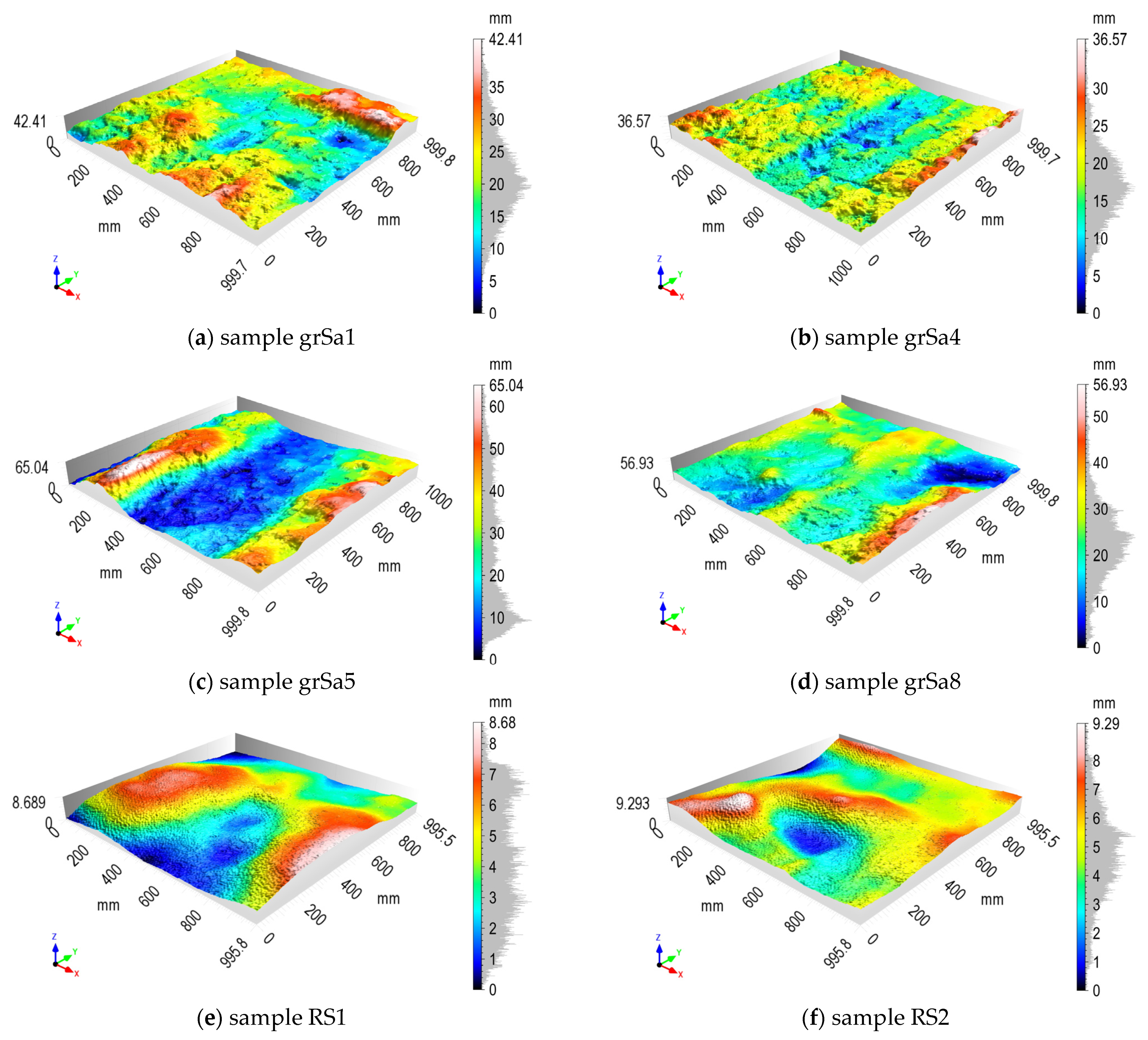
3. Results
4. Discussion
5. Conclusions
- determination of the values of significant parameters of surface roughness;
- separation of geotechnical layers with various roughness;
- estimation of the parameter δ (friction angle between the retaining wall surface and the soil), which is a function of the wall surface roughness and the angle of internal friction of the soil;
- more reliable calculation of earth pressure in separate geotechnical layers;
- obtainment of roughness parameters with practical significance for earth active and passive pressure calculation.
Author Contributions
Funding
Institutional Review Board Statement
Informed Consent Statement
Data Availability Statement
Acknowledgments
Conflicts of Interest
Appendix A
Appendix B


References
- Zaczek-Peplinska, J.; Podawca, K.; Karsznia, K. Reliability of geodetic control measurements of high dams as a guarantee of safety of the construction and the natural environment. Bull. Polish Acad. Sci. Tech. Sci. 2018, 66, 87–98. [Google Scholar]
- Zaczek-Peplinska, J.; Kowalska, M.E.; Łapiński, S.; Grzyb, M. Multi-temporal survey of diaphragm wall with terrestrial laser scanning method. Open Geosci. 2020, 12, 656–667. [Google Scholar] [CrossRef]
- Grzempowski, P.; Badura, J.; Milczarek, W.; Blachowski, J.; Głowacki, T.; Zając, M. Determination of the Long-Term Ground Surface Displacements Using a PSI Technique—Case Study on Wrocław. Appl. Sci. 2020, 10, 3343. [Google Scholar] [CrossRef]
- Wujanz, D.; Neitzel, F.; Hebel, H.P.; Linke, J.; Busch, W. Terrestrial radar and laser scanning for deformation monitoring: First steps towards assisted radar scanning. ISPRS Ann. Photogramm. Remote Sens. Spat. Inf. Sci. 2013, II-5/W2, 325–330. [Google Scholar] [CrossRef] [Green Version]
- Lee, C.N.; Oh, J.H. Measurement of Soil Deformation around the Tip of Model Pile by Close-Range Photogrammetry. J. Korean Soc. Surv. Geod. Photogramm. Cartogr. 2013, 31, 173–180. [Google Scholar] [CrossRef] [Green Version]
- Oats, R.; Escobar-Wolf, R.; Oommen, T. A Novel Application of Photogrammetry for Retaining Wall Assessment. Infrastructures 2017, 2, 10. [Google Scholar] [CrossRef] [Green Version]
- Gorska, K.; Muszyński, Z.; Rybak, J. Displacement Monitoring and Sensitivity Analysis in the Observational Method. Stud. Geotech. Mech. 2014, 35, 25–43. [Google Scholar] [CrossRef]
- Rybak, J.; Ivannikov, A.; Kulikova, E.; Żyrek, T. Deep excavation in urban areas—Defects of surrounding buildings at various stages of construction. MATEC Web Conf. 2018, 146, 2012. [Google Scholar] [CrossRef] [Green Version]
- Oskouie, P.; Becerik-Gerber, B.; Soibelman, L. Automated measurement of highway retaining wall displacements using terrestrial laser scanners. Autom. Constr. 2016, 65, 86–101. [Google Scholar] [CrossRef]
- Lindenbergh, R.; Pietrzyk, P. Change detection and deformation analysis using static and mobile laser scanning. Appl. Geomat. 2015, 7, 65–74. [Google Scholar] [CrossRef]
- Jaboyedoff, M.; Oppikofer, T.; Abellán, A.; Derron, M.-H.; Loye, A.; Metzger, R.; Pedrazzini, A. Use of LIDAR in landslide investigations: A review. Nat. Hazards 2012, 61, 5–28. [Google Scholar] [CrossRef] [Green Version]
- Mitew-Czajewska, M. Evaluation of deep excavation impact on surrounding structures—A case study. In Underground Infrastructure of Urban Areas 3; CRC Press: Boca Raton, FL, USA, 2014; pp. 161–172. ISBN 9781-138026520. [Google Scholar]
- Eling, D. Terrestrisches Laserscanning für die Bauwerksüberwachung; Deutsche Geodätische Kommission bei der Bayerischen Akademie der Wissenschaften, Reihe C: Munich, Germany, 2009. [Google Scholar]
- González-Aguilera, D.; Lagüela, S.; Rodríguez-Gonzálvez, P.; Hernández-López, D. Image-based thermographic modeling for assessing energy efficiency of buildings faç ades. Energy Build. 2013, 65, 29–36. [Google Scholar] [CrossRef]
- Milan, D.J. Terrestrial Laser Scan-derived Topographic and Roughness Data for Hydraulic Modelling of Gravel-bed Rivers. In Laser Scanning for the Environmental Sciences; Heritage, G.L., Large, A.R.G., Eds.; Wiley: Hoboken, NJ, USA, 2009; pp. 133–146. ISBN 9781405157179. [Google Scholar]
- Schabowicz, K. Non-destructive testing of materials in civil engineering. Materials 2019, 12, 3237. [Google Scholar] [CrossRef] [Green Version]
- Bond, A.; Harris, A. Decoding Eurocode 7; Taylor & Francis: London, UK, 2008; ISBN 97802-03937723. [Google Scholar]
- Kozubal, J.; Wróblewski, R.; Muszyński, Z.; Wyjadłowski, M.; Stróżyk, J. Non-Deterministic Assessment of Surface Roughness as Bond Strength Parameters between Concrete Layers Cast at Different Ages. Materials 2020, 13, 2542. [Google Scholar] [CrossRef] [PubMed]
- Li, Y.H.; Lv, M.F.; Guo, Y.C.; Huang, M.S. Effects of the soil water content and relative roughness on the shear strength of silt and steel plate interface. Measurement 2021, 174, 109003. [Google Scholar] [CrossRef]
- Kong, S.-M.; Lee, Y.-J. Application of close range photogrammetry to passive and active retaining wall model tests and numerical analysis. In Geotechnical Aspects of Underground Construction in Soft Ground; CRC Press: Boca Raton, FL, USA, 2014; pp. 309–314. ISBN 9781138027008. [Google Scholar]
- Plaxis, B.V. Plaxis 2D, Version 2012a; Windows 32-bit; Plaxis BV: Delft, The Netherlands, 2012. [Google Scholar]
- European Committee for Standardization, EN 1992-1-1:2004 Eurocode 2: Design of Concrete Structures—Part 1-1: General Rules and Rules for Buildings; European Committee for Standardization: Geneva, Switzerland, 2004.
- International Organization for Standardization. PN-EN ISO 25178-2:2012. Geometrical Product Specifications (GPS)—Surface Texture: Areal—Part 2: Terms, Definitions and Surface Texture Parameters (ISO 25178-2:2012); International Organization for Standardization: Geneva, Switzerland, 2012. [Google Scholar]
- Valsson, S.M. Earth Pressures against- and Stability of Retaining Structures; University of Iceland: Reykjavík, Iceland, 2011. [Google Scholar]
- Coulomb, C.A. Essai sur une application des regles de maximis et minimis a quelques problemes de statique relatifs a l’architecture (Essay on maximums and minimums of rules to some static problems relating to architecture). Acad. R. Des Sci. 1973, 7, 343–382. [Google Scholar]
- Rankine, W.J. On the Stability of Loose Earth. Philos. Trans. R. Soc. London 1857, 147, 9–27. [Google Scholar]
- Caquot, A.I.; Kérisel, J.L. Tables for the Calculation of Passive Pressure, Active Pressure and Bearing Capacity of Foundations; Gautier-Villars: Paris, France, 1948. [Google Scholar]
- Polish Committee for Standardization. PN-EN 1997-1:2008 Eurocode 7: Geotechnical Design—Part 1: General Rules; Polish Committee for Standardization: Warsaw, Poland, 2008. (In Polish)
- Orr, T.; Babatunde, O.A. Earth Pressures on Retaining Structures. Int. J. Sci. Eng. Res. 2017, 8, 715–723. [Google Scholar] [CrossRef]
- Grande, L.O. Samvirke Mellom pel og Jord; Norwegian Institute of Technology: Trondheim, Norway, 1976. [Google Scholar]
- Zogg, H.-M.M. Investigations of High Precision Terrestrial Laser Scanning with Emphasis on the Development of a Robust Close-Range 3D-Laser Scanning System; ETH: Zürich, Switzerland, 2008. [Google Scholar]
- Feng, Q. Advantages by phase-based 3D laser scanning techniques to underground construction. In Proceedings of the ISRM International Symposium—EUROCK 2012, Stockholm, Sweden, 28–30 May 2012. [Google Scholar]
- Pfeifer, N.; Briese, C. Laser scanning—Principles and applications. In Proceedings of the GeoSiberia 2007—International Exhibition and Scientific Congress; European Association of Geoscientists & Engineers, Novosibirsk, Russia, 25 April 2014. [Google Scholar]
- Frohlich, C.; Mettenleiter, M. Terrestrial laser scanning—New perspectives in 3D surveying. Int. Arch. Photogramm. Remote Sens. Spat. Inf. Sci. 2004, 36, 2. [Google Scholar]
- Van Genechten, B.; Santana Quintero, M.; Luis Lerma, J.L.; Heine, E.; Caner, H.; Hankar, M.; De Bruyne, M.; Poelman, R. Theory and Practice on Terrestrial Laser Scanning—Training Material Based on Practical Applications; Santana Quintero, M., Lerma, J.L., Heine, E., Van Genechten, B., Eds.; Universidad Politécnica de Valencia: Valencia, Spain, 2008; ISBN 97884-83633120. [Google Scholar]
- Donati, S. Electro-Optical Instrumentation: Sensing and Measuring with Lasers; Pearson Education: Upper Saddle River, NJ, USA, 2004; ISBN 97801-32597548. [Google Scholar]
- Kabała, C.; Bekier, J.; Bińczycki, T.; Bogacz, A.; Bojko, O.; Cuske, M.; Ćwieląg-Piasecka, I.; Dębicka, M.; Gałka, B.; Gersztyn, L.; et al. Soils of Lower Silesia: Origins, Diversity and Protection; Kabała, C., Ed.; Polish Society of Soil Science, Wrocław Branch, Polish Humic Substances Society: Wrocław, Poland, 2015; ISBN 978-83-934096-4-8. [Google Scholar]
- Mitew-Czajewska, M.; Siemińska-Lewandowska, A. Design of deep excavations according to Eurocode 7. Stud. Geotech. Mech. 2008, 30, 207–214. [Google Scholar]
- Gorska, K.; Brząkała, W. On safety of slurry-wall trenches. Stud. Geotech. Mech. 2008, 30, 198–206. [Google Scholar]
- RIEGL Laser Measurement Systems GmbH. RiSCAN PRO Operating & Processing Software, Version 2.9 (r9569); Windows 64-bit; RIEGL Laser Measurement Systems GmbH: Horn, Austria, 2019. [Google Scholar]
- Borana, L.; Yin, J.H.; Singh, D.N.; Shukla, S.K.; Pei, H.F. Influences of Initial Water Content and Roughness on Skin Friction of Piles Using FBG Technique. Int. J. Geomech. 2017, 17, 4016097. [Google Scholar] [CrossRef]
- Kishida, H.; Vesugi, M. Tests of the interface between sand and steel in the simple shear apparatus. Int. J. Rock Mech. Min. Sci. Geomech. Abstr. 1987, 24, 134. [Google Scholar] [CrossRef]
- Mathia, T.G.; Pawlus, P.; Wieczorowski, M. Recent trends in surface metrology. Wear 2011, 271, 494–508. [Google Scholar] [CrossRef]
- Deltombe, R.; Kubiak, K.J.; Bigerelle, M. How to select the most relevant 3D roughness parameters of a surface. Scanning 2014, 36, 150–160. [Google Scholar] [CrossRef] [PubMed] [Green Version]
- Pagani, L.; Qi, Q.; Jiang, X.; Scott, P.J. Towards a new definition of areal surface texture parameters on freeform surface. Measurement 2017, 109, 281–291. [Google Scholar] [CrossRef]
- Sadowski, Ł.; Czarnecki, S.; Hoła, J. Evaluation of the height 3D roughness parameters of concrete substrate and the adhesion to epoxy resin. Int. J. Adhes. Adhes. 2016, 67, 3–13. [Google Scholar] [CrossRef]
- Wieczorowski, M. Theoretical basis of spatial analysis of surface asperities (in Polish). Inżynieria Masz. 2013, 18, 7–34. [Google Scholar]
- Hoła, J.; Sadowski, Ł.; Reiner, J.; Stankiewicz, M. Concrete surface roughness testing using nondestructive three-dimensional optical method. NDE Saf. Defektosk. Sec. Czech Repub. 2012, 6, 101–105. [Google Scholar]
- Sadowski, Ł.; Hoła, J.; Czarnecki, L.; Mathia, T.G. New paradigm in the metrology of concrete surface morphology: Methods, parameters and applications. Measurement 2021, 169, 108497. [Google Scholar] [CrossRef]
- Muszyński, Z.; Wyjadłowski, M. Assessment of the Shear Strength of Pile-to-Soil Interfaces Based on Pile Surface Topography Using Laser Scanning. Sensors 2019, 19, 1012. [Google Scholar] [CrossRef] [PubMed] [Green Version]
- Surface Roughness Measurement—Parameters|Olympus. Available online: https://www.olympus-ims.com/en/metrology/surface-roughness-measurement-portal/parameters/#!cms[focus]=cmsContent14709 (accessed on 25 May 2021).
- Filtration Techniques—Surface Metrology Guide—Digital Surf. Available online: https://guide.digitalsurf.com/en/guide-filtration-techniques.html (accessed on 31 July 2021).
- Senin, N.; Blunt, L. Characterisation of individual areal features. In Characterisation of Areal Surface Texture; Springer: Berlin, Germany, 2013; Volume 9783642364, pp. 179–216. ISBN 97836-42364587. [Google Scholar]
- CloudCompare, Version 2.10.2 (Zephyrus) Stereo. Windows 64-bit; License: GNU GPL (General Public License). 2021. Available online: www.cloudcompare.org (accessed on 24 February 2019).
- Digital Surf. Mountains Map, Version 8.2; Windows 64-bit; Digital Surf: Besançon, France, 2021. [Google Scholar]
- Seo, H. Tilt mapping for zigzag-shaped concrete panel in retaining structure using terrestrial laser scanning. J. Civ. Struct. Health Monit. 2021, 11, 851–865. [Google Scholar] [CrossRef]
- International Organization for Standardization. EN ISO 14688-1:2018-05 Geotechnical Investigation and Testing—Identification and Classification of Soil—Part 1 Identification and Description; ISO: Geneva, Switzerland, 2018. [Google Scholar]
- Gorska, K.; Wyjadłowski, M. Analysis of displacement of excavation based on inclinometer measurements. Stud. Geotech. Mech. 2013, 34, 3–16. [Google Scholar] [CrossRef] [Green Version]
- Comité Euro-International du Béton. Secretariat Permanent. CEB-FIB MODEL CODE 2010. First Complete Draft—Volume 1; Comité Euro-International du Béton: Lausanne, Switzerland, 2010. [Google Scholar]
- Comité Euro-International du Béton. Secretariat Permanent. CEB-FIB MODEL CODE 2010. First Complete Draft—Volume 2; Comité Euro-International du Béton: Lausanne, Switzerland, 2010. [Google Scholar]


| Name of Parameter | Definition |
|---|---|
| Height parameters | |
| Root-mean-square height | |
| Skewness | |
| Kurtosis | |
| Maximum height | |
| Arithmetic mean height | |
| Hybrid parameters | |
| Developed interfacial area ratio | |
| Functional Volume Parameters | |
| Peak material volume | |
| Core material volume | |
| Core void volume | |
| Dale void volume | |
| Surface | φ | δ | Ka δ = 0.00 | Kp δ = 0.00 |
|---|---|---|---|---|
| [°] | [°] | [–] | [–] | |
| concrete/Mg | 29 | 0 | 0.36 | 3.0 |
| concrete/MSa | 33 | 0 | 0.33 | 3.2 |
| concrete/grSa | 38 | 0 | 0.24 | 3.5 |
| Surface | φ | δ | φ / δ | Ka δ/φ = 0.66 | Kp δ/φ = 0.66 |
|---|---|---|---|---|---|
| [°] | [°] | [–] | [–] | [–] | |
| concrete/Mg | 29 | 19.1 | 0.66 | 0.30 | 4.3 |
| concrete/MSa | 33 | 21.7 | 0.66 | 0.26 | 5.6 |
| concrete/grSa | 38 | 25.0 | 0.66 | 0.20 | 8.1 |
| Surface | Surface Parameter (Average) | Surface Type | δ | Ka | Kp | ||||
|---|---|---|---|---|---|---|---|---|---|
| Sa | Sz | Sdr | Vmp | Vvc | |||||
| [mm] | [mm] | [%] | [mL/m²] | [mL/m²] | [°] | [-] | [-] | ||
| reference concrete | 1.5 | 9.0 | 0.1 | 60 | 2198 | smooth/very smooth | 0 | - | - |
| concrete/Mg | 5.8 | 46.4 | 5.2 | 284 | 8587 | very rough | 23 | 0.29 | 4.5 |
| concrete/MSa | 3.5 | 35.0 | 1.6 | 426 | 5277 | rough/very rough | 27 | 0.22 | 6.0 |
| concrete/grSa | 7.7 | 52.0 | 2.6 | 436 | 12193 | very rough | 32 | 0.19 | 8.9 |
Publisher’s Note: MDPI stays neutral with regard to jurisdictional claims in published maps and institutional affiliations. |
© 2021 by the authors. Licensee MDPI, Basel, Switzerland. This article is an open access article distributed under the terms and conditions of the Creative Commons Attribution (CC BY) license (https://creativecommons.org/licenses/by/4.0/).
Share and Cite
Wyjadłowski, M.; Muszyński, Z.; Kujawa, P. Application of Laser Scanning to Assess the Roughness of the Diaphragm Wall for the Estimation of Earth Pressure. Sensors 2021, 21, 7275. https://doi.org/10.3390/s21217275
Wyjadłowski M, Muszyński Z, Kujawa P. Application of Laser Scanning to Assess the Roughness of the Diaphragm Wall for the Estimation of Earth Pressure. Sensors. 2021; 21(21):7275. https://doi.org/10.3390/s21217275
Chicago/Turabian StyleWyjadłowski, Marek, Zbigniew Muszyński, and Paulina Kujawa. 2021. "Application of Laser Scanning to Assess the Roughness of the Diaphragm Wall for the Estimation of Earth Pressure" Sensors 21, no. 21: 7275. https://doi.org/10.3390/s21217275
APA StyleWyjadłowski, M., Muszyński, Z., & Kujawa, P. (2021). Application of Laser Scanning to Assess the Roughness of the Diaphragm Wall for the Estimation of Earth Pressure. Sensors, 21(21), 7275. https://doi.org/10.3390/s21217275