The Influence of Surface Topography on the Weak Ground Shaking in Kathmandu Valley during the 2015 Gorkha Earthquake, Nepal

 ,
,  ,
,  , and
, and
Abstract
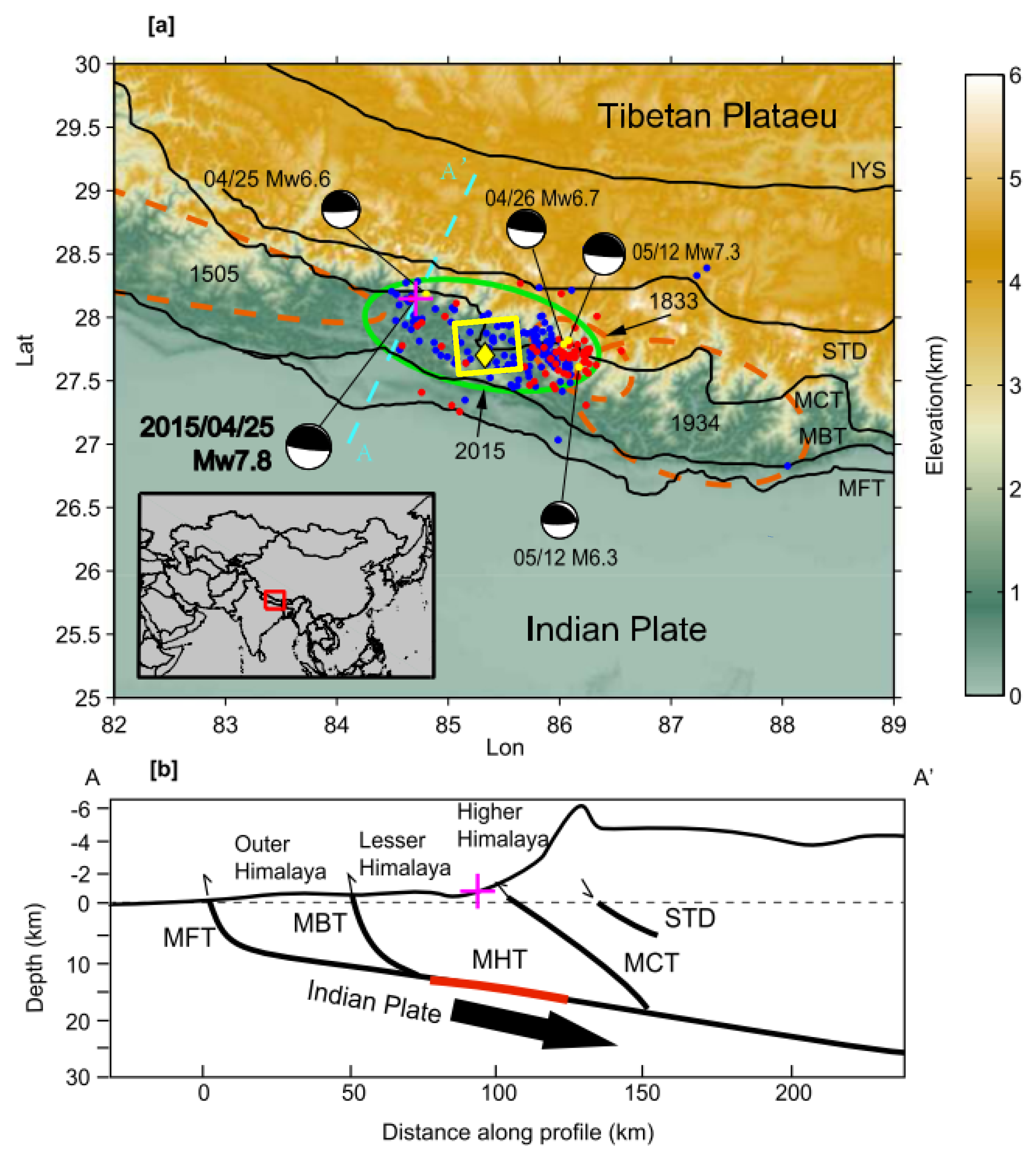
1. Introduction
2. Data and Methods
2.1. Satellite Based Topography
2.2. Model Construction
2.3. Earthquake Simulation
2.4. Simulation Output
2.5. Evaluation of Directional Effects
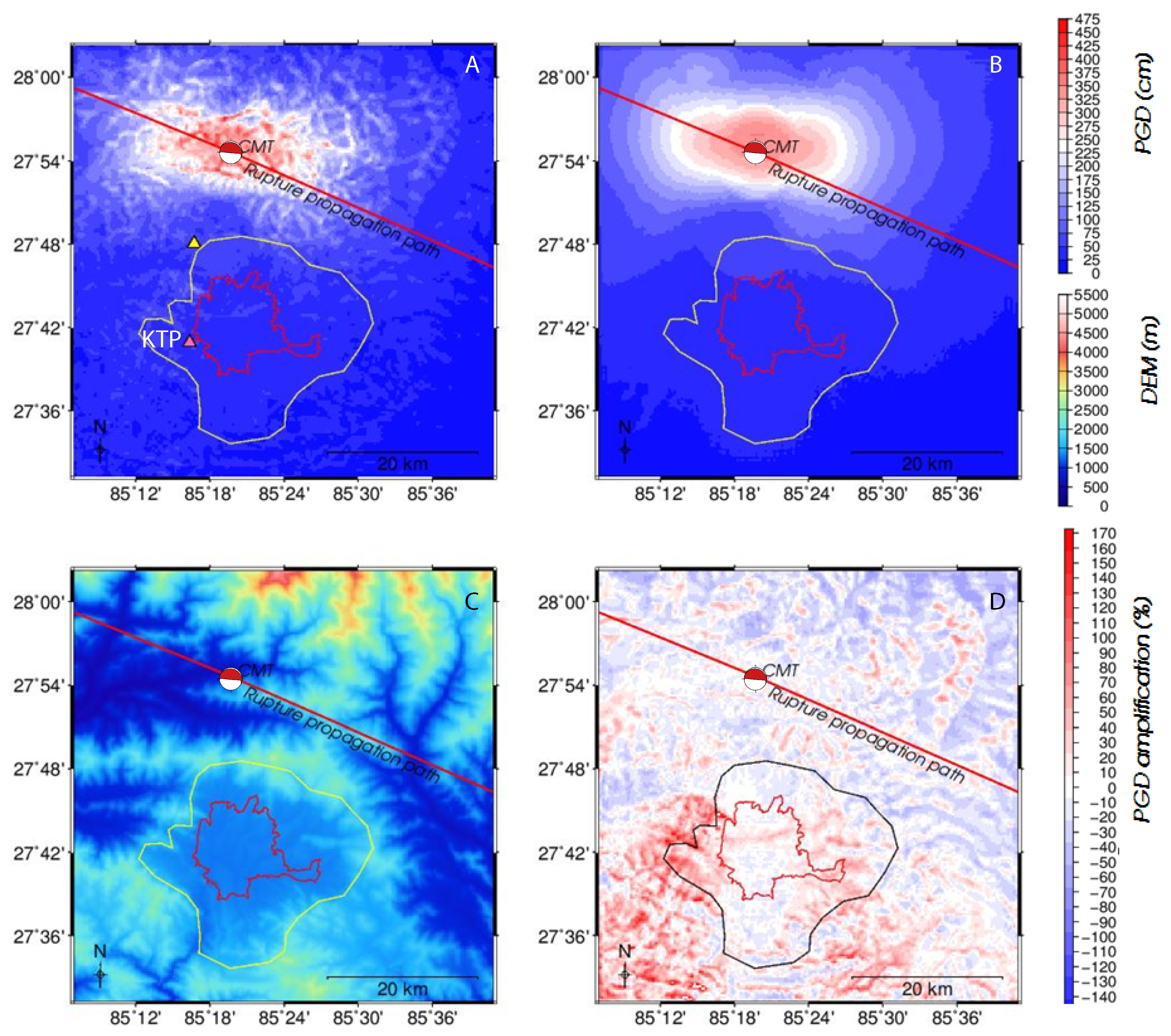
3. Results
3.1. Model Results
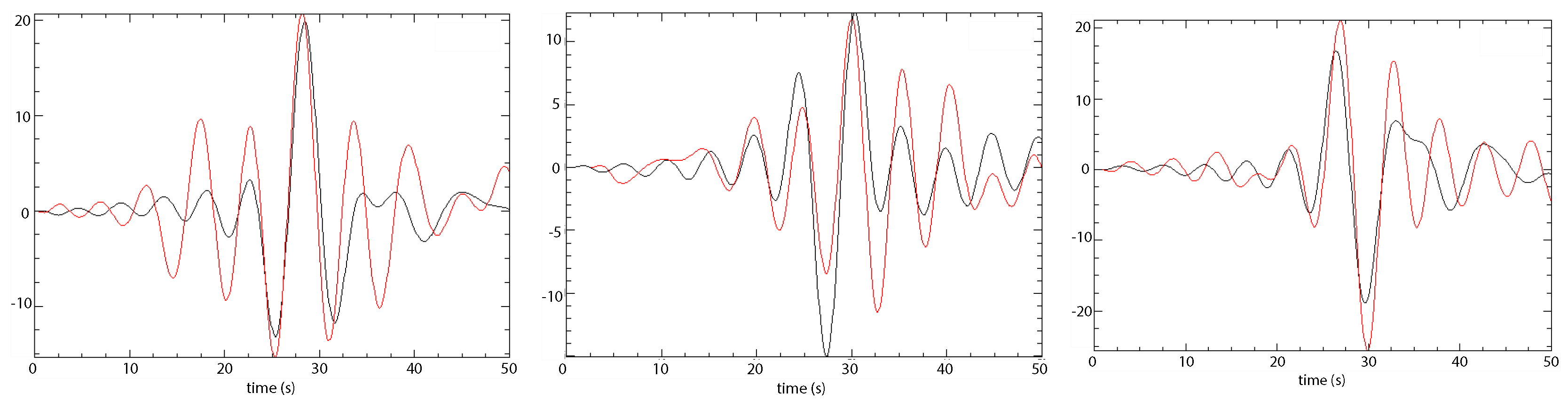
3.2. Model Validation
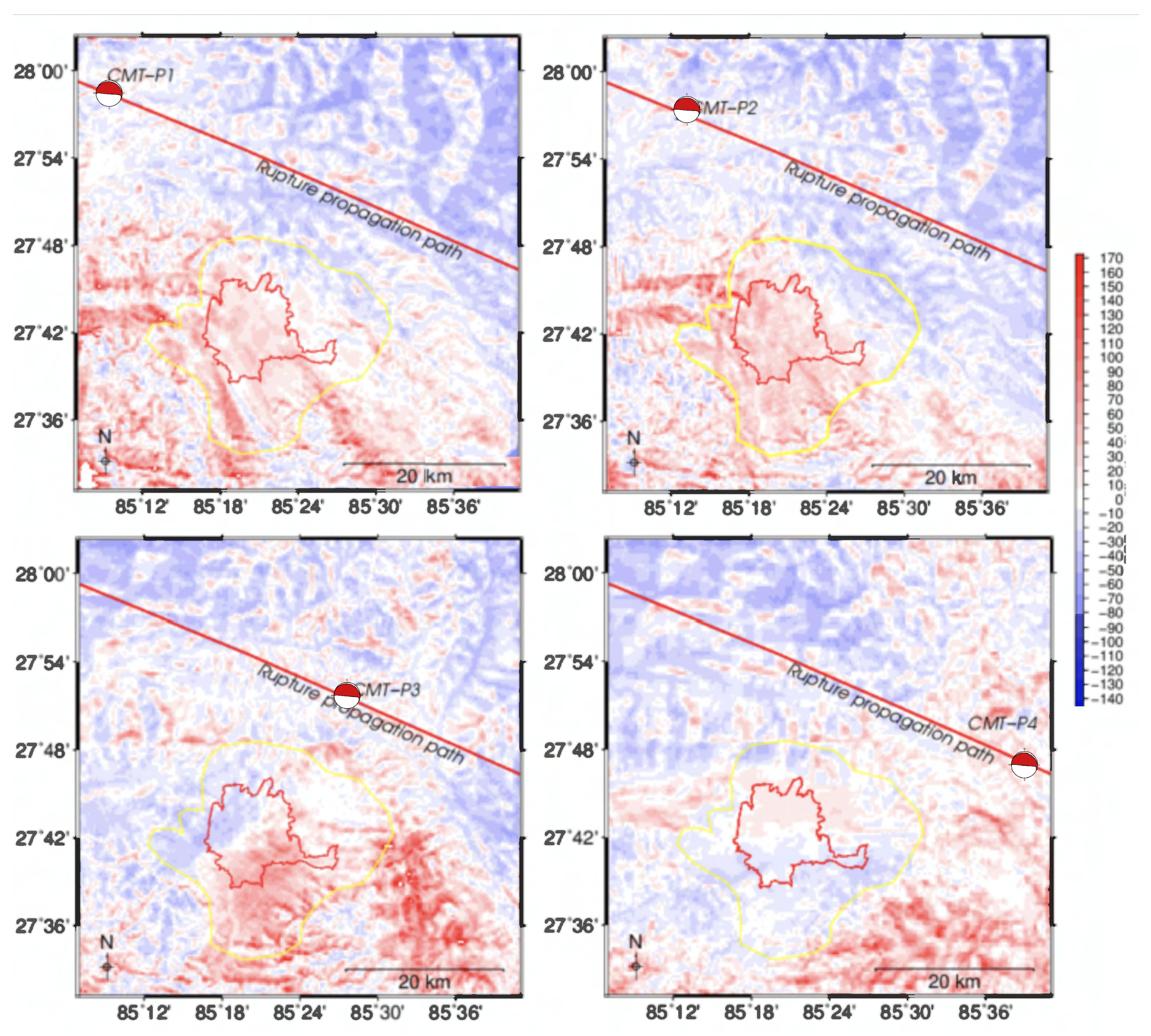
3.3. Evaluation of Directional Effects
4. Discussion
5. Conclusions
Author Contributions
Funding
Acknowledgments
Conflicts of Interest
References
- Showstack, R. Weak shaking lessened Nepal earthquake impact. Eos 2015, 96. [Google Scholar] [CrossRef]
- Martin, S.S.; Hough, S.E.; Hung, C. Ground motions from the 2015 Mw 7.8 Gorkha, Nepal, earthquake constrained by a detailed assessment of macroseismic data. Seismol. Res. Lett. 2015, 86, 1524–1532. [Google Scholar] [CrossRef]
- Detweiler, S.; Reddy, P.R. The 2015 M7.8 Gorkha, Nepal, earthquake: Possible implications for Northeastern India. J. Ind. Geophys. Union 2016, 20, 291–294. [Google Scholar]
- Moss, R.E.S.; Thompson, E.M.; Kieffer, D.S.; Tiwari, B.; Hashash, Y.M.A.; Acharya, I.; Adhikari, B.R.; Asimaki, D.; Clahan, K.B.; Collins, B.D.; et al. Geotechnical effects of the 2015 magnitude 7.8 Gorkha, Nepal, earthquake and aftershocks. Seismol. Res. Lett. 2015, 86, 1514–1523. [Google Scholar] [CrossRef]
- Grunthal, G. The European Macroseismic Scale EMS-98. In Cahiers du Centre Europeen de Geodynamique et de Seismologie 15; Centre Europeen de Geodynamique et de Seismologie: Luxembourg, 1998; pp. 99–100. [Google Scholar]
- USGS. One Year after the M7.8 Nepal Earthquake. Technical Report; 2016. Available online: https://www.usgs.gov/news/one-year-after-m78-nepal-earthquake (accessed on 18 October 2019).
- The Government of Nepal and Disaster Preparedness Network-Nepal. Nepal disaster report 2015. 2015. Available online: http://www.drrportal.gov.np/uploads/document/329.pdf (accessed on 18 October 2019).
- Dixit, M.; Yatabe, R.; Dahal, R.K.; Bhandary, N.P. Public School Earthquake Safety Program in Nepal. Geomatics Nat. Hazards Risks 2014, 5, 293–319. [Google Scholar] [CrossRef]
- Wei, S.; Chen, M.; Wang, X.; Graves, R.; Lindsey, E.; Wang, T.; Karakaş, Ç.; Helmberger, D. The 2015 Gorkha (Nepal) earthquake sequence: I. Source modeling and deterministic 3D ground shaking. Tectonophysics 2018. [Google Scholar] [CrossRef]
- Hough, S.E. Introduction to the focus section on the 2015 Gorkha, Nepal, earthquake. Seismol. Res. Lett. 2015, 86, 1502–1505. [Google Scholar] [CrossRef]
- Hashash, Y.M.A.; Tiwari, B.; Moss, R.E.S.; Asimaki, D.; Clahan, K.B.; Kieffer, D.S.; Dreger, D.S.; Macdonald, A.; Madugo, C.M.; Mason, H.B.; et al. Geotechnical Field Reconnaissance: Gorkha (Nepal) Earthquake of April 25 and Related Shaking Sequence. 2015. Available online: https://digitalcommons.calpoly.edu/cgi/viewcontent.cgi?article=1314&context=cenv_fac (accessed on 21 January 2020).
- Galetzka, J.; Melgar, D.; Genrich, J.F.; Geng, J.; Owen, S.; Lindsey, E.O.; Xu, X.; Bock, Y.; Avouac, J.P.; Adhikari, L.B.; et al. Slip pulse and resonance of the Kathmandu basin during the 2015 Gorkha earthquake, Nepal. Science 2015, 349, 1091–1095. [Google Scholar] [CrossRef]
- Lindsey, E.O.; Natsuaki, R.; Xu, X.; Shimada, M.; Hashimoto, M.; Melgar, D.; Sandwell, D.T. Line-of-sight displacement from ALOS-2 interferometry: Mw 7.8 Gorkha earthquake and Mw 7.3 aftershock. Geophys. Res. Lett. 2015, 42, 6655–6661. [Google Scholar] [CrossRef]
- Avouac, J.P.; Meng, L.; Wei, S.; Wang, T.; Ampuero, J.P. Lower edge of locked Main Himalayan Thrust unzipped by the 2015 Gorkha earthquake. Nat. Geosci. 2015, 8, 708–711. [Google Scholar] [CrossRef]
- Grandin, R.; Vallee, M.; Satriano, C.; Lacassin, R.; Klinger, Y.; Simoes, M.; Bollinger, L. Rupture process of the Mw = 7.9 2015 Gorkha earthquake (Nepal): Insights into Himalayan megathrust segmentation. Geophys. Res. Lett. 2015, 42, 8373–8382. [Google Scholar] [CrossRef]
- Chen, M.; Wei, S. The 2015 Gorkha, Nepal, earthquake sequence: II. broadband simulation of ground motion in Kathmandu. Bull. Seismol. Soc. Am. 2019, 109, 672–687. [Google Scholar] [CrossRef]
- Yang, Y.; Chen, Q.; Xu, Q.; Liu, G.; Hu, J.C. Source model and Coulomb stress change of the 2015 Mw 7.8 Gorkha earthquake determined from improved inversion of geodetic surface deformation observations. J. Geod. 2019, 93, 333–351. [Google Scholar] [CrossRef]
- Shen, W.; Li, Y.; Zhang, J. Hybrid stochastic ground motion modeling of the Mw 7.8 Gorkha, Nepal earthquake of 2015 based on InSAR inversion. J. Asian Earth Sci. 2017, 141, 268–278. [Google Scholar] [CrossRef]
- Rajaure, S.; Asimaki, D.; Thompson, E.M.; Hough, S.; Martin, S.; Ampuero, J.P.; Dhital, M.R.; Inbal, A.; Takai, N.; Shigefuji, M.; et al. Characterizing the Kathmandu Valley sediment response through strong motion recordings of the 2015 Gorkha earthquake sequence. Tectonophysics 2017. [Google Scholar] [CrossRef]
- Varum, H.; Furtado, A.; Rodrigues, H.; Dias-Oliveira, J.; Vila-Pouca, N.; Arêde, A. Seismic performance of the infill masonry walls and ambient vibration tests after the Ghorka 2015, Nepal earthquake. Bull. Earthq. Eng. 2017, 15, 1185–1212. [Google Scholar] [CrossRef]
- Dhakal, Y.P.; Kubo, H.; Suzuki, W.; Kunugi, T.; Aoi, S.; Fujiwara, H. Analysis of strong ground motions and site effects at Kantipath, Kathmandu, from 2015 Mw 7.8 Gorkha, Nepal, earthquake and its aftershocks. Earth Planets Space 2016, 68. [Google Scholar] [CrossRef]
- Bhattarai, M.; Adhikari, L.B.; Gautam, U.P.; Laurendeau, A.; Labonne, C.; Hoste-Colomer, R.; Sèbe, O.; Hernandez, B. Overview of the large 25 April 2015 Gorkha, Nepal, Earthquake from accelerometric perspectives. Seismol. Res. Lett. 2015, 86, 1540–1548. [Google Scholar] [CrossRef]
- Takai, N.; Shigefuji, M.; Rajaure, S.; Bijukchhen, S.; Ichiyanagi, M.; Dhital, M.R.; Sasatani, T. Strong ground motion in the Kathmandu Valley during the 2015 Gorkha, Nepal, earthquake. Earth Planets Space 2016, 68. [Google Scholar] [CrossRef]
- Kurashimo, E.; Sato, H.; Sakai, S.; Hirata, N.; Gajurel, A.; Adhikari, D.; Subedi, K.; Yagi, H.; Upreti, B. The 2015 Gorkha earthquake: Earthquake reflection imaging of the source fault and connecting seismic structure with fault slip behavior. Geophys. Res. Lett. 2019, 46, 3206–3215. [Google Scholar] [CrossRef]
- USGS. M 7.8—36km E of Khudi, Nepal. Technical Report; 2015. Available online: https://earthquake.usgs.gov/earthquakes/eventpage/us20002926#finite-fault (accessed on 18 October 2019).
- Khan, S.; van der Meijde, M.; van der Werff, H.; Shafique, M. The impact of mesh and DEM resolution in SEM simulation of 3D seismic response. Bull. Seismol. Soc. Am. 2017, 107, 2151–2159. [Google Scholar] [CrossRef]
- Qin, W.; Yao, H. Characteristics of subevents and three-stage rupture processes of the 2015 Mw 7.8 Gorkha Nepal earthquake from multiple-array back projection. J. Asian Earth Sci. 2017, 133, 72–79. [Google Scholar] [CrossRef]
- Komatitsch, D.; Tsuboi, S.; Tromp, J. The spectral-element method in seismology. In Seismic Earth: Array Analysis of Broadband Seismograms; Levander, A., Nolet, G., Eds.; American Geophysical Union: Washington, DC, USA, 2005; pp. 205–227. [Google Scholar]
- Tromp, J.; Komatitsch, D.; Liu, Q. Spectral-element and adjoint methods in seismology. Commun. Comput. Phys. 2008, 3, 1–32. [Google Scholar]
- Shafique, M.; van der Meijde, M.; Kerle, N.; van der Meer, F. Impact of DEM source and resolution on topographic seismic amplification. Int. J. Appl. Earth Obs. Geoinf. 2011, 13, 420–427. [Google Scholar] [CrossRef]
- Sandia National Laboratories. The CUBIT Geometry and Mesh Generation Toolkit. Technical Report; 2015. Available online: https://cubit.sandia.gov/ (accessed on 18 October 2019).
- Casarotti, E.; Stupazzini, M.; Lee, S.J.; Komatitsch, D.; Piersanti, A.; Tromp, J. CUBIT and seismic wave propagation based upon the spectral-element method: An advanced unstructured mesher for complex 3D geological media. In Proceedings of the 16th International Meshing Roundtable, Seattle, WA, USA, 14–17 October 2007; pp. 579–597. [Google Scholar] [CrossRef]
- Cupillard, P.; Delavaud, E.; Burgos, G.; Festa, G.; Vilotte, Y.C.; Montagner, J.P. RegSEM: A versatile code based on the spectral element method to compute seismic wave propagation at the regional scale. Geophys. J. Int. 2012, 188, 1203–1220. [Google Scholar] [CrossRef]
- Computational Infrastructure for Geodynamics. Specfem3d Cartesian. Technical Report. 2017. Available online: https://geodynamics.org/cig/software/specfem3d/ (accessed on 18 October 2019).
- Ichiyanagi, M.; Takai, N.; Shigefuji, M.; Bijukchhen, S.; Sasatani, T.; Rajaure, S.; Dhital, M.R.; Takahashi, H. Aftershock activity of the 2015 Gorkha, Nepal, earthquake determined using the Kathmandu strong motion seismographic array. Earth Planets Space 2016, 68. [Google Scholar] [CrossRef]
- Monsalve, G.; Sheehan, A.; Schulte-Pelkum, V.; Rajaure, S.; Pandey, M.R.; Wu, F. Seismicity and one-dimensional velocity structure of the Himalayan collision zone: Earthquakes in the crust and upper mantle. J. Geophys. Res. 2006, 111. [Google Scholar] [CrossRef]
- Mahesh, P.; Rai, S.S.; Sivaram, K.; Paul, A.; Gupta, S.; Sarma, R.; Gaur, V.K. One- dimensional reference velocity model and precise location of earthquake hypocenter in the Kumaon-Garhawal Himalaya. Bull. Seismol. Soc. Am. 2013, 103, 328–339. [Google Scholar] [CrossRef]
- Ekstrom, G.; Nettles, M.; Dziewonski, A.M. The global CMT project 2004-2010: Centroid-moment tensors for 13,017 earthquakes. Phys. Earth Planet. Inter. 2012, 200–201, 1–9. [Google Scholar] [CrossRef]
- Kramer, S.L. Geotechnical Earthquake Engineering; Prentice-Hall: Upper Saddle River, NJ, USA, 1996; pp. 55–75. [Google Scholar]
- Dhanya, J.; Gade, M.; Raghukanth, S.T.G. Ground motion estimation during 25th April 2015 Nepal earthquake. Acta Geodaetica et Geophysica 2015, 52, 69–93. [Google Scholar] [CrossRef]
- Lee, S.J.; Chen, H.W.; Liu, Q.; Komatitsch, D.; Huang, B.S.; Tromp, J. Three-Dimensional simulations of seismic wave propagation in the Taipei Basin with realistic topography based upon the spectral-element method. Bull. Seismol. Soc. Am. 2008, 98, 253–264. [Google Scholar] [CrossRef]
- Fan, W.; Shearer, P.M. Detailed rupture imaging of the 25 April 2015 Nepal earthquake using teleseismic P waves. Geophys. Res. Lett. 2015, 42, 5744–5752. [Google Scholar] [CrossRef]


| Model Parameters and Simulation Process | Mesh (with Topo) | Mesh (without Topo) |
|---|---|---|
| Mesh dimension (km) | 56.5 * 57.9 * 57 | 56.5 * 57.9 * 57 |
| Total number of elements (million) | 0.855 | 0.842 |
| Average GLL distance at surface (m) | 61.25 | 60.5 |
| Number of grid points (million) | 56.3 | 55.2 |
| Number of degrees of freedom (million) | 168.9 | 165.6 |
| Mesh slices (number of processors) | 16 | 16 |
| Simulation time (seconds) | 90 | 90 |
| Number of time steps | 300,000 | 300,000 |
| Step (seconds) | 0.0003 | 0.0003 |
© 2020 by the authors. Licensee MDPI, Basel, Switzerland. This article is an open access article distributed under the terms and conditions of the Creative Commons Attribution (CC BY) license (http://creativecommons.org/licenses/by/4.0/).
Share and Cite
van der Meijde, M.; Ashrafuzzaman, M.; Kerle, N.; Khan, S.; van der Werff, H. The Influence of Surface Topography on the Weak Ground Shaking in Kathmandu Valley during the 2015 Gorkha Earthquake, Nepal. Sensors 2020, 20, 678. https://doi.org/10.3390/s20030678
van der Meijde M, Ashrafuzzaman M, Kerle N, Khan S, van der Werff H. The Influence of Surface Topography on the Weak Ground Shaking in Kathmandu Valley during the 2015 Gorkha Earthquake, Nepal. Sensors. 2020; 20(3):678. https://doi.org/10.3390/s20030678
Chicago/Turabian Stylevan der Meijde, Mark, Md Ashrafuzzaman, Norman Kerle, Saad Khan, and Harald van der Werff. 2020. "The Influence of Surface Topography on the Weak Ground Shaking in Kathmandu Valley during the 2015 Gorkha Earthquake, Nepal" Sensors 20, no. 3: 678. https://doi.org/10.3390/s20030678
APA Stylevan der Meijde, M., Ashrafuzzaman, M., Kerle, N., Khan, S., & van der Werff, H. (2020). The Influence of Surface Topography on the Weak Ground Shaking in Kathmandu Valley during the 2015 Gorkha Earthquake, Nepal. Sensors, 20(3), 678. https://doi.org/10.3390/s20030678